


Consultants Volume 22, Number 1 | 2022 WATER, WATER, EVERYWHERE Stream and Wetland Restoration in North Texas
News from SWCA Environmental


WATER, WATER, EVERYWHERE Stream and Wetland Restoration in North Texas 4 EPHEMERAL BUT NOT FORGOTTEN SWCA Works to Protect Playas on the Ogallala Aquifer 20 THE LOST BARN SWCA Helps Preserve History at Emily Dickinson Museum 10 WHAT A DOG’S NOSE KNOWS Developing a Canine Detection Service at SWCA 22 UNDER THE SHADE THEY FLOURISH Beginning a 10-Year Turtle Study in Belize 12 A TALE OF TWO RIVERS How Comprehensive Management Planning Can Benefit Ecosystems 26 CONTENTS SUMMER 2022
FOCUS: A Time of Renewal

We’ve made it through two solid years of a global pandemic and we’re emerging stronger than ever. As we each become more confident in our safety and the safety of others, we can make more space for new ideas, fresh energy, and excitement about the impact we create every day.
In this issue of The Wire, we’re featuring several articles that focus on how we are partnering with our clients to protect the planet’s most valuable resource – water. In our cover story, we dive into the details of restoring, creating, and enhancing nearly 69 miles of streams and 8,500 acres of wetlands in northern Texas. We have a great team of SWCA experts and partners on the ground literally transforming former cattle pastures and agricultural fields into a thriving ecosystem to support growing communities in the area. If you want to learn more about Priority 1 stream restoration, this one is for you (“Water, Water Everywhere: Stream and Wetland Restoration in North Texas”, page 4 ). Learn about how our team developed an assessment method and prioritization standards for playas to create a GIS-based hotspot map to preserve these vital geological features across the Great Plains (“Ephemeral But Not Forgotten: SWCA Works to Protect Playas on the Ogallala Aquifer”, page 20). And see how the development of comprehensive management plans for segments of two of the West’s most important rivers—the Green and the Colorado—can benefit ecosystems and communities while encouraging agency collaboration (“A Tale of Two Rivers”, page 26 ).

Digging into literary history, we also share how our Cultural Resources specialists uncovered nearly 2,000 artifacts for the Emily Dickinson Museum as it looks to continue enhancing the Museum’s experience for visitors who come from around the world to learn about the author’s legacy (“The Lost Barn: SWCA Helps Preserve History at Emily Dickinson Museum”, page 10).
Every day our people tap into their passion and use research to bring sound science and creative solutions forward. Check out a photo collection from our SWCA scientists, led by Eric Munscher, who traveled to Belize to break ground on the first-ever population survey for turtles in the area (“Under the Shade They Flourish: Beginning A 10-Year Turtle Study in Belize”, page 12). You can also meet Moxie, a lovable and energetic springer spaniel who sniffs out bird and bat fatalities at wind farms, trained by staff biologist Allison Locatell, who has spent years developing a canine detection service at SWCA in hopes of providing a more accurate and efficient method to find rare or cryptic wildlife (“What a Dog’s Nose Knows”, page 22).
Simply reading these stories again inspires me and I look forward to continuing to bring this renewed sense of energy and excitement to all the work we do. For more information, please contact Joseph J. Fluder, III, CEO


TOC
in North Texas
An afternoon thunderstorm rolls across the plains of northern Texas and on the banks of the Red River, the former cattle pastures and agricultural fields at Riverby Ranch slowly begin to fill with water. But there is no cause for concern; in fact, everything is going according to plan. As the North Texas Municipal Water District (NTMWD) creates the area’s first major reservoir in nearly 30 years only a few miles from the Ranch, SWCA’s stream and wetland restoration plans will offset habitat lost to the new lake’s rising waters with a flood of its own—creating protected waterways and wetlands where cattle once grazed.

BOIS D’ARC LAKE

About seven miles upstream of the Ranch, Bois d’Arc Lake is taking shape. Once filled, the 16,641-acre lake will provide a critical supply of drinking water for two million people in north Texas, helping meet the demands of the area’s growing population.

In addition to the much-needed drinking water, Bois d’Arc Lake will also provide a variety of recreational opportunities for residents and visitors flocking to the area. Fannin County expects to see hundreds of millions of dollars in new economic activity each year between the construction of waterfront homes and associated property taxes, hotel occupancy taxes, visitor spending, and 2,400 new long-term jobs in the area. As one can expect for something of this scale, this new lake has been a long time coming. Planning and permitting for the project began in 2003. Riverby Ranch, the 15,000-acre mitigation area and location of SWCA-designed streams and wetlands, was purchased in 2010. Construction of the dam on Bois d’Arc Creek and water treatment plant began in 2018, followed by boat ramps, recreational facilities, and six miles of new road, including a 1.3-mile bridge bisecting the lake. New pipelines were also needed to move raw water to the treatment plant in nearby Leonard, Texas, and treated water further southwest to McKinney, Texas, where it will connect to NTMWD’s 610+ mile water supply network that serves two million people in about 80 communities across 10 Texas counties.

WATER, WATER, EVERYWHERE Stream and Wetland Restoration
The new 16,641-acre Bois d’Arc reservoir and lake will provide a critical supply of drinking water for 2 million people in north Texas
to fill enough
TOC
Map credit: North Texas Municipal Water District Bois d'Arc Lake – It could take up to two years for the reservoir
to
open for recreation. Image credit: North Texas Municipal Water District
MITIGATION AT RIVERBY RANCH

Under Section 404 of the Clean Water Act, the U.S. Army Corps of Engineers (USACE) led an Environmental Impact Statement (EIS) for this project and approved a mitigation plan to address any unavoidable environmental impacts. For example, during construction, some areas of timber were left at the lake site to become submerged aquatic habitat while other portions were removed. NTMWD needed to mitigate, or offset, impacts like this habitat loss by creating new habitat or improving existing environments in another location. Freese and Nichols, Inc., provided an original mitigation plan in January 2017, which NTMWD was required to implement.
NTMWD purchased Riverby Ranch and the Upper Bois d’Arc Creek Mitigation Site upstream of Bois d’Arc Lake to mitigate the unavoidable impacts associated with the lake. The mitigation plan includes planting more than five million trees and restoring or enhancing 8,500 acres of wetlands and


69 miles of stream channels. Once completed, this will be one of the largest approved mitigation efforts in the U.S. for a single permitted project.
Resource Environmental Solutions (RES), the nation’s largest ecological restoration company and turn-key providers for the mitigation project, brought SWCA on board to design the stream and wetland restoration components of the comprehensive Permittee Responsible Mitigation (PRM) project. SWCA also worked with several subconsultants on the design plan, including Five Smooth Stones Restoration, Tailwater Limited, Green Water Restoration, and Simple Design Solutions, LLC. It can often take decades for the environmental improvements at a mitigation site to become self-sustaining, so RES will monitor and maintain the site for the next 20 years or until all the regulatory mitigation requirements are met, whichever comes first.
5 million trees being planted 8,500 acres of wetland and 69 miles of stream channels restored or enhanced Once completed, this will be one of the largest approved mitigation efforts in the U.S. for a single permitted project Vegetation planted beside the channel helps stabilize the banks and prevent future erosion TOC
STREAM CHANNEL DESIGN
From the 1800s, farmers and ranchers in the area straightened, channelized, or relocated many of the stream channels at Riverby Ranch to improve drainage. Farmers dug ditches to drain some of the naturally occurring wetlands to create more suitable farmland on the property. This human intervention resulted in much shorter streams that became disconnected from their historic floodplains over time and downcut, where erosion cuts a deeper and narrower path into the stream’s active channel, often causing stream banks to fail.
To improve the condition of approximately 70 miles of stream channels on the property, SWCA’s restoration designs focused on two main options as required by NTMWD’s mitigation plan: 1) enhance and protect existing stream channels that were still in manageable condition, or 2) restore highly degraded streams and their connection to adjacent floodplains and wetlands, with particular focus on the streams’ cross-sectional dimensions, aerial patterns, and longitudinal profiles.
Stream Enhancement

Of the two options, enhancing existing streams is a relatively straightforward process. Planting native grasses and trees along the banks help stabilize and protect the streams from

further erosion. Dense vegetation in the riparian zone can slow down rushing waters during a runoff event. Plant roots help lock the soil into place, keeping it from eroding into the water and washing downstream. Vegetation also regulates stream water temperature, which is important for fish and aquatic habitats.
Stream Restoration
Stream restoration, on the other hand, is more complex. The dimension, pattern, and profile of any particular stream, known as its form, is a result of all streams’ natural tendency to move water and sediments that enter the system most efficiently. The most efficient form always includes a connection of the stream channel to a nominally wide floodplain at the bankfull discharge, which is also known as the channel-forming, effective, or dominant discharge. Stable streams have a form that neither degrades nor aggrades and is in dynamic equilibrium with the contributing watershed water and sediment loads.
Once a stream or its watershed is altered, the dynamic equilibrium is disturbed and the channel will enter a channel evolution process to establish a new stable form at a lower elevation, including the development of a new, entrenched geomorphic floodplain connected to the new, lower channel

Human intervention of existing stream at Riverby Ranch resulted in shorter streams disconnected from historic floodplain and eroded, narrower paths that caused stream banks to fail.
Once construction is complete water flow is diverted into the new channel. Crews fill in old stream.
 Existing Condition with Downcut Banks (Jan. 2019) During Construction (June 2020)
After Construction (September 2020)
Willow Branch Creek stream enhancement and restoration
Existing Condition with Downcut Banks (Jan. 2019) During Construction (June 2020)
After Construction (September 2020)
Willow Branch Creek stream enhancement and restoration
TOC
Newly designed stream is constructed adjacent to original stream with proper dimension, pattern, profile and connection to the original upper floodplain.
at bankfull discharge. Although this channel evolution process results in a new stable channel, the downcutting process results in a disconnection from the original floodplain and a lowering of the groundwater table. Both results have a significant negative impact on the historic wetlands that were part of the original floodplain.
As such, when restoring an ecosystem at watershed-scale, including streams, floodplains, and wetlands, the preferred stream restoration approach is to raise the degraded, downcut stream back up to the original floodplain. This is done by designing and constructing a new stream adjacent to the original stream that has the proper dimension, pattern, profile, and connection to the original upper floodplain. This is referred to as Priority I stream restoration.


If a stream on Riverby Ranch was too degraded to prevent the channel evolution process or was already downcut from the original floodplain, SWCA designed a Priority I stream restoration plan. Once construction is complete, water flow is diverted into the new channel and crews fill in the old stream with excavated dirt or section it off into small oxbow ponds to store excess water and recharge groundwater in drier months.
The gradual slope and stream structures of new channels slow down water flow, which decelerates the degradation process and promotes growth of vegetation.

Willow Branch, the largest designed channel on the property, is an excellent example. As seen in the aerial photo, the newly constructed channel lies to the left of the degraded channel. The team turned the degraded channel into a series of open-water ponds by installing multiple plugs; these ponds now serve as additional aquatic habitat next to the newly restored channel. This restoration will provide frequent floodwaters and a very shallow groundwater table to help restore the wetlands on the floodplain. Since the restored stream is stable and in dynamic equilibrium, it will not degrade or aggrade. Therefore, SWCA, along with RES and Wright Contracting, LLC, crews, was able to restore in-channel aquatic habitat features consisting of riffles and pools, woody debris, and aquatic and bankside vegetation without the fear that they will be destroyed in the channel evolution process.
 Before (February 2019)
During Construction (March 2019) After (September 2020)
Before (February 2019)
During Construction (March 2019) After (September 2020)
TOC
Ragsdale Creek enhancement and restoration
WETLAND DESIGN

Creating wetlands is another important mitigation technique at work at Riverby Ranch. SWCA’s design plan for this area consisted of forested wetlands and emergent wetlands. Here, forested wetlands use terraced berms to collect and trap rainfall in areas growing mostly with trees. One way to create emergent wetlands is for crews to construct large depressions in the ground to collect rainfall as well as water flowing down nearby slopes or from natural springs. Emergent wetlands typically have herbaceous plants like grasses or reeds that live near the water’s edge.
On average, areas of north Texas receive about 36 inches of rainfall each year. So, rain is not the issue—the water simply needs a little gentle persuasion about where to go once it lands. The berms RES has constructed are ridges up to two feet tall and made of fill dirt, with strategically placed outlet structures that help restrict drainage. By building them to cross slopes on the topography, precipitation falling upslope of the berm is slowed down as it flows across the landscape. This helps water infiltrate into the soil and native vegetation establish and grow, restoring the former pastures of Riverby Ranch back to wetlands. The team also restored the historic topographic landscape of these wetland areas by constructing hundreds of shallow macro depressions that fill like a puddle in a backyard, retaining water for wildlife for longer periods during the dry season.


 Erosion control matting to stabilize the newly constructed stream channel
Newly constructed stream channel
Priority 1 Stream Restoration – Hunt Bottom Branch after construction
A new channel is constructed next to old channel. The new channel provides frequent floodwaters and a very shallow groundwater table to help restore the wetlands on the floodplain.
Erosion control matting to stabilize the newly constructed stream channel
Newly constructed stream channel
Priority 1 Stream Restoration – Hunt Bottom Branch after construction
A new channel is constructed next to old channel. The new channel provides frequent floodwaters and a very shallow groundwater table to help restore the wetlands on the floodplain.
TOC
Old channel
A LEGACY FOR FUTURE GENERATIONS


From the first permanent settlements of hunter-gatherers to the megacities they later spawned, humans have always shaped our world to meet our growing needs, and projects like this are no exception. Only in our recent history, however, have we had the forethought, and legislative encouragement, to offset our environmental impacts with watershed-scale ecological restoration projects. Where one tree is removed, another puts down roots. Where a stream is dammed and a grassland or forest inundated, thousands of acres of new habitat are carefully constructed, maintained, and permanently protected in its stead. Future generations will have the opportunity to enjoy these natural landscapes and healthy ecosystems, and thanks to this forward-thinking balancing act between NTMWD’s Bois d’Arc Lake and Mitigation Project, millions of people in north Texas will be able to put down their own roots and have the water they need to grow. For more information, please contact


 Joseph Zhang and Lee Forbes
Vegetation along the banks regulates stream water temperature, which is important for fish and aquatic habitats
Wetland berm holding water (October 2019)
The next generation of environmental stewards is already enjoying Riverby Ranch. Image credit: Resource Environmental Solutions
Emergent wetlands are created by constructing large depressions to collect rainfall and water flowing from nearby slopes.
Joseph Zhang and Lee Forbes
Vegetation along the banks regulates stream water temperature, which is important for fish and aquatic habitats
Wetland berm holding water (October 2019)
The next generation of environmental stewards is already enjoying Riverby Ranch. Image credit: Resource Environmental Solutions
Emergent wetlands are created by constructing large depressions to collect rainfall and water flowing from nearby slopes.
TOC
Stream enhancement included planting native grasses and trees along the banks to help stabilize and protect the streams from further erosion.
THE LOST BARN
SWCA Helps Preserve History at the Emily Dickinson Museum


Though mostly unknown during her reclusive and eccentric life, Emily Dickinson’s vast collection of poems published after her death established her legacy as one of America’s most influential poets. Her home, built in the early 1800s, is preserved and open to the public as part of the Emily Dickinson Museum in Amherst, Massachusetts. People come from around the world to be transported into a different time through touring the property and learning about the author’s legacy.
Any renovation done on the property is regulated by preservation restrictions under the National Register Property to ensure nothing disturbs the historic nature of the site. The Director of the Emily Dickinson Museum approached SWCA in early 2021 to help them stay in accordance with these preservation restrictions during an upcoming maintenance renovation. The museum planned to install HVAC systems on-site with utility lines running across the backyard to an adjacent street.
Thanks to investigations done by the University of Massachusetts (UMass) over the past 20 years, the museum learned that, in addition to the two established historic sites on the property, the home of Emily Dickinson and her neighboring brother, there was also a barn that had been knocked down in the early 20th century.
Interested in building a historic replica of the backyard barn, the museum needed to know its exact location in order to not run utility lines through the original foundation or unintentionally destroy any artifacts during construction.
After receiving a permit from the Massachusetts Historic Commission, SWCA’s cultural resources team performed an archaeological survey in the fall of 2021 to look for remnants of the barn and determine the exact whereabouts of the barn foundation. The crew included Nadia Waski, Zachary Nason, Brian Deshler, Darrell Geisler, and Austin Escott.
The Emily Dickinson Museum
We turn not older with years, but newer every day.
– Emily Dickinson
We are pleased to work with the Emily Dickinson Museum on this project. This is a great opportunity to help preserve the legacy of one of America’s treasured authors.
TOC
– Chris Donta, Project Manager and Cultural Resources Team Lead
Using location projections provided by UMass, the team spent a week surveying three sites in the back of the property. They used shovels and trowels to dig trenches and skim dirt through sifting screens, uncovering nearly 2,000 artifacts in total, including brick fragments and nails from the barn, a penny from the 1800s, pottery pieces, remnants of the structure, and more. All of the artifacts will be added to the museum’s collection.

“We dig a lot of holes, so it’s fun when we actually dig some things up,” said Chris Donta, Project Manager and Cultural Resources Team Lead. "Each place has a unique history. After 25 years, it’s still exciting; you never know what you’re going to find."


SWCA determined the location of the east wall of the barn foundation, but due to later developments on top of the site, were not able to locate the west wall.

The team sent a summary of their findings to museum staff, including an artifact catalog and a full report write-up with a recommendation on where to place the utility lines in order to not interfere with the barn foundation.

Construction of a replica barn is still a ways off, but the museum has asked SWCA to return to monitor the installation of utility lines in early 2022.
“Niagara Falls from the American side”, a flow blue transfer print serving platter from Enoch Wood & Sons, ca. 1829 to 1846

“We are pleased to work with the Emily Dickinson Museum on this project,” Donta said. “This is a great opportunity to help preserve the legacy of one of America’s treasured authors.” For more information, please contact Chris Donta
 SWCA crew performing archaeological excavation on-site
Refit of whiteware dish with maker’s mark, excavated from Test Unit 1, Feature 1, ca. 1851 to 1882 by James Edwards & Son Dalehall
Stacked dry-laid stone wall remnants of the east barn foundation wall
SWCA crew performing archaeological excavation on-site
Refit of whiteware dish with maker’s mark, excavated from Test Unit 1, Feature 1, ca. 1851 to 1882 by James Edwards & Son Dalehall
Stacked dry-laid stone wall remnants of the east barn foundation wall
TOC
Test Unit 1, Feature 1, refit of flow blue whiteware platter with a Chinese-style motif, ca. late 18th to early 19th century
UNDER THE SHADE THEY FLOURISH
Beginning a 10-Year Turtle Study in Belize

A team of SWCA scientists spent years planning a research trip to an understudied part of the world to build the first turtle population baseline for a decade-long study. It culminated in 10 days spent in the dense rainforest of Belize catching as many turtles as possible. Check out the highlights from the trip in this photo essay and read the full story on SWCA.com.

Sub Umbra Floreo, “Under The Shade I Flourish” – Belize National Motto
TOC
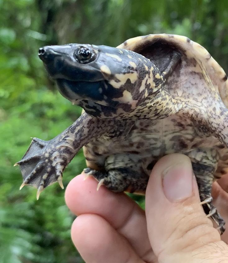
Juvenile Giant Mexican Musk Turtle


TOC
Meso American Snapping Turtle
The nonprofits Turtle Survival Alliance and the Belize Foundation for Research and Environmental Education (BFREE) led and funded the study, performed within BFREE’s 1,153-acre parcel of owned rainforest for conservation and research.

SWCA Herpetologist Eric Munscher, Natural Resources Project Manager Arron Tuggle, and the crew caught as many turtles as possible during their study window to provide the most robust population baseline they could. They marked each turtle found and microchipped the adults. Future study crews will gather information from the chips and compare statistics to gain insight into population growth or decline, ages of turtles, and their apparent health. "Depending on capture success it could take seven to 10 years of data to build a solid population model," said Eric.
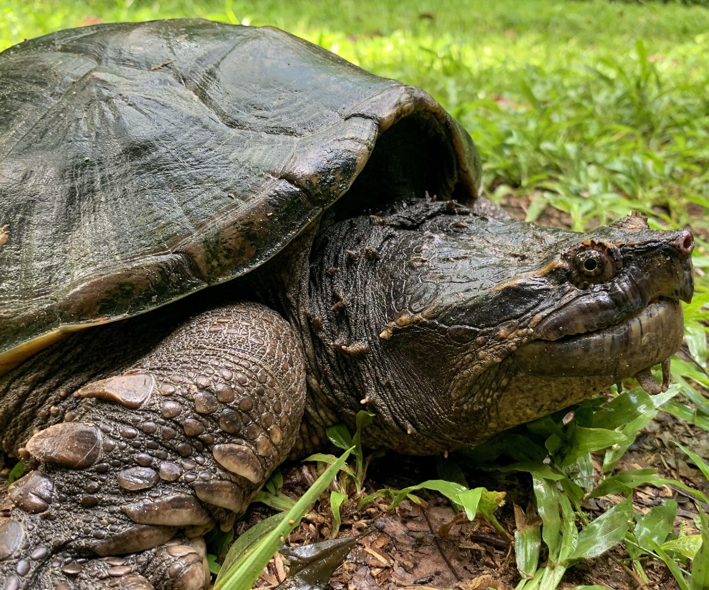 Meso American Snapping Turtle
TOC
Eric Munscher, who led the initial kick-off of this multi-year study, holds a juvenile Hicatee, a highly endangered species of turtle in Belize that is bred at BFREE (a species not included in this study).
Swampy pools of water where the team of scientists laid traps to capture a variety of mud and snapping turtles.

 Eric Munscher and a BFREE Wildlife Fellow/University of Florida Graduate Student observe a Meso American Snapping Turtle.
TOC


TOC
Giant Mexican Musk Turtle
Giant Mexican Musk Turtles have been experiencing habitat loss and poaching throughout their range. A full-size Giant Mexican Musk turtle can weigh approximately 30 lbs. Researchers will use the study findings for a range of applications, including annual reports to the Belizean fisheries department as well as peer-reviewed publications.


“When Arron and our team planned this study, we had high expectations to see lots of turtles and most of the species,” said Eric Munscher. “Once we arrived, we were amazed by the number of turtles we caught. We were able to catch-mark-and-release 272 turtles within the study’s duration and see seven of the eight species we were hoping to see.”
 Giant Mexican Musk Turtle
Studies like these will help us understand not just what’s on our property, but also what’s in the south of Belize and what would be compromised through unsustainable development.
– BFREE Deputy Director Heather Barrett
TOC
Arron Tuggle holds two Giant Mexican Musk Turtles.
Information from the study will provide currently undocumented information to herpetologists, such as confirming—or correcting—suspected ranges of some species.
For example, on this first trip, the team found 53 Tabasco Mud Turtles in an area that proved a roughly 50-mile range extension of where the species was previously known to exist. Relatively little is known about the Tabasco Mud Turtle, in large part because it can be difficult to find.


“The Tabasco Mud Turtle is really neat because they only come out after it rains and you can find them in puddles and these little ephemeral pools,” said Arron Tuggle. “But nobody really knows what they do when those ephemeral pools dry up. Do they go into the leaf litter? Do they burrow down into the substrate?” The team, though, will have to wait until another leg of the multi-year study to see if it can uncover the answers to those questions.

Development is not the only risk to Belize turtles. While none of the species in the area are classified as protected, turtle advocates are concerned that numbers are dwindling, in part because turtles are a traditional meal for holidays and celebrations.

Do the population numbers in Belize look to be healthy? According to Eric Munscher, it is too early to tell, but the numbers for some species look promising. Findings to the other end of the spectrum, though, could lead toward further study into whether certain species are at risk.
Teams of scientists will regularly visit the site – Eric Munscher plans to return to southern Belize annually to join upcoming survey rounds – over the next several years to build a solid population model and provide valuable scientific information about turtles in this area. Learn more on how to get involved with the Turtle Survival Alliance and BFREE . Read the full story on SWCA.com. For more information, please contact Eric Munscher White-Lipped Mud Turtle
TOC
Tabasco Mud Turtle


TOC
EPHEMERAL BUT NOT FORGOTTEN
SWCA Works to Protect Playas on the Ogallala Aquifer
playas
Playas are shallow, depressional, and ephemeral wetlands that provide important ecological benefits to the landscape, such as flood water retention and water filtration, as well as critical habitat for wildlife. There are over 80,000 playas in the Great Plains region alone, making them the most numerous type of wetland in the region. Serving as the primary water level recharge points for the underlaying Ogallala Aquifer, the main water source for the public and for irrigation within the Great Plains, the presence of these playas is essential.
Unfortunately, these playas are under threat from sedimentation from surrounding croplands. Soil runoff from the croplands affects the playas’ natural hydrology and size. The sediment accumulation reduces the playas’ potential water capacity, causing an increased rate of evaporation and limiting the ability for the water to drain into the aquifer below.

As the Great Plains region increasingly struggles with drought and declining aquifers, the protection of these playas is paramount to the survival of the region and its inhabitants.
“It has been widely recognized that these playas are critical for wildlife at local and landscape levels, but they are also crucial for clean water for the region,” said Willow Malone, biologist in SWCA’s Denver office. “We recognize that land management and working with landowners and energy developers is key to protecting these playas.”
A CALL TO ACTION
According to the federal government, playas are considered ephemeral as they are depressions that hold water but are not always saturated. Because of these transitory properties, playas are not considered “waters of the United States” and are not legally protected by the Clean Water Act by the U.S. Environmental Protection Agency and U.S. Army Corps of Engineers. This poses problems for the future of playas as a clean water resource and important habitat and stopover point for birds.
Luckily, there has been a concerted effort by landowners, conservation groups, and energy companies to take a proactive approach toward mitigating impacts. To assist with protection efforts, Willow, along with a large, companywide team at SWCA, worked to develop a standardized assessment method and prioritization standards for playas to create a GIS “hotspot map”. The hotspot map prioritizes individual and clusters of playas based on their current ecological quality to target the playas most in need of conservation and avoidance of developmental impacts.
“Our clients actively strive to avoid these playa clusters,” Willow said. “This map helps them in these efforts.”
GIS MAPPING AND BEYOND
SWCA’s team developed this standardized hotspot model with the help of Playa Lakes Joint Venture’s (PLJV’s) most recent Probable Playa Version 5 dataset, peer-reviewed literature, and the PLJV playa quality standards.
Eight criteria were considered for the avoidance ranking model: dominant land cover, playa size, playa connectivity, health status of the playa, oil and gas infrastructure presence, evidence of farming, presence of hydrological modifications, and road and railroad presence.
The hotspot map encourages developers to coordinate with landowners, federal and state agencies, and wildlife conservation groups to update the project layout and avoid sensitive areas. These local conservation efforts cascade to the landscape level, benefiting the industry, wildlife, and public on a large scale.
With the creation of this GIS ranking model, SWCA is assisting developers in protecting unique and critical habitats throughout the Great Plains. For more information, please contact Willow Malone.
 Scattered across the western Great Plains is an unprotected, yet vital geological feature:
TOC


PLAYA AVOIDANCE RANKING MODEL Eight criteria were considered when developing the avoidance ranking model for hotspot mapping: Snapshot of playa locations and avoidance priority status as assessed by SWCA for an undisclosed location Map of the Ogallala Aquifer and its playas; there are over 80,000 playas in the Great Plains region alone. Image provided by PLJV Dominant land COVER 1 Playa SIZE 2 Playa CONNECTIVITY 3 HEALTH status of the playa 4 Evidence of FARMING 6 OIL and GAS infrastructure presence 5 Presence of HYDROLOGICAL MODIFICATIONS 7 ROAD and RAILROAD presence 8 TOC
WHAT A DOG’S NOSE KNOWS
That’s Moxie, a 3-year-old springer spaniel who sniffs out bird and bat fatalities on wind farms. Moxie loves her job and she is very good at it.


A dog’s sense of smell is estimated to be 10,000 to 100,000 times better than a human’s, meaning a dog’s nose knows better how to find by smell what human eyes often miss. Since the 1990s, dogs have been making their way into environmental field work, detecting things like underground oil contamination, and endangered and invasive species of plants and animals.
Human-led field surveys for particular species can be tedious and expensive, sometimes coming up empty-handed altogether. With their powerful noses able to locate odors over large distances, dogs are much better suited to locating species in difficult survey conditions. Allison Locatell, a staff biologist in SWCA’s Arlington, Texas, office, was convinced there was a way around our natural limitations.
She found what she was looking for at the 2017 Wildlife Society Conference in Reno, Nevada, during a presentation of results from an avian and bat fatality monitoring study that used detection dogs. Allison had more than seven years of dog training experience in her personal life, training dogs for obedience competitions, Canine Good Citizen evaluations, therapy work, and service work. She was instantly intrigued and began collaborating with the biologists who gave the presentation, as well as several groups of dog trainers, to learn all she could about environmental detection dogs. Six months later, on her first avian and bat fatality monitoring survey for SWCA, she saw firsthand why dogs would be better in challenging conditions.
“As the surveyor, I was supposed to visually find fatalities as small as a mouse in a field of chest-high vegetation where I couldn’t even see my own feet,” Allison said. ”Knowing there was
Allison and Moxie on-site at an SWCA client's wind farm
TOC
Imagine having a coworker who is innately talented at a particular task, finishes in a fraction of the time it would take you, and does it all with unwavering determination and endless enthusiasm.
a better solution and wanting the best results for our clients, I asked others at SWCA about using dogs. When I was given the go-ahead to investigate it further, I ran with it.”
“This was a great example of a creative solution we strive to find for our clients,” said Josh Perry, Director of SWCA’s Arlington office, about Allison’s suggestion to use dogs in field studies. "Taking on a project like this speaks volumes to the creativity and entrepreneurial spirit of so many of SWCA’s technical staff.”
Allison began detection training in 2018 and adopted Moxie in 2020. While working with Moxie and developing her own training and fieldwork strategy, Allison was collaborating with other SWCA offices to design a searcher efficiency trial that gained the attention of two SWCA clients. In May 2021, the clients each allowed SWCA to use one of their wind farms as test sites to compare human surveyor and canine searcher efficiency.
The trials were held within a single season in three vegetation levels commonly found on wind farms. Trial Site #1 had bare ground agricultural fields, and Trial Site #2 had medium coverage (ankle height vegetation) and difficult coverage (knee height). Surveys for bat and quail carcasses compared the canine-handler team and a human surveyor on the same days, each searching for the same sample carcasses. To avoid the possibility of scent contamination, another SWCA teammate walked to randomly generated points within each turbine plot and tossed the carcass 10 to 15 feet. Each turbine was searched by the canine-handler team first, then by the human so the canine would not follow a teammate’s scent to each carcass.
The end results of the trials were exactly what Allison and SWCA had expected: Moxie greatly outperformed the human surveyor. The canine-handler team performed 73% better than the human surveyor on Site #1 and 147% better on Site #2 with more difficult vegetation cover. Not only did the canine-handler team find more
carcasses, but they also finished an average of 10 to 16 minutes faster per turbine, even accounting for playtime with Moxie’s favorite toy after each find. Toy time is key for Moxie—it is her reward for successful fatality detection. "High energy and other qualities are important in a detection dog, but a toy obsession is the most necessary characteristic," Allison said. That obsession for the reward is why Moxie is willing to work so hard.
Since the trials were performed on active wind farms, finding real-world bird and bat fatalities was a known possibility. Both survey teams found incidental fatalities in addition to the sample carcasses. However, the most challenging and impressive of these finds were made only by Moxie, who was able to find a
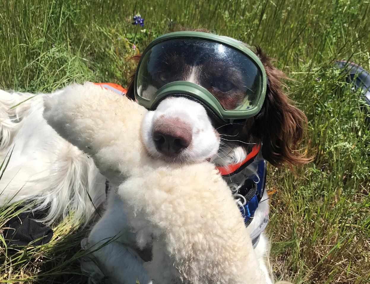
 Goggles protect Moxie’s eyes from irritants and impacts when moving quickly through dense vegetation. Playtime with a sheepskin toy is her reward after each find.
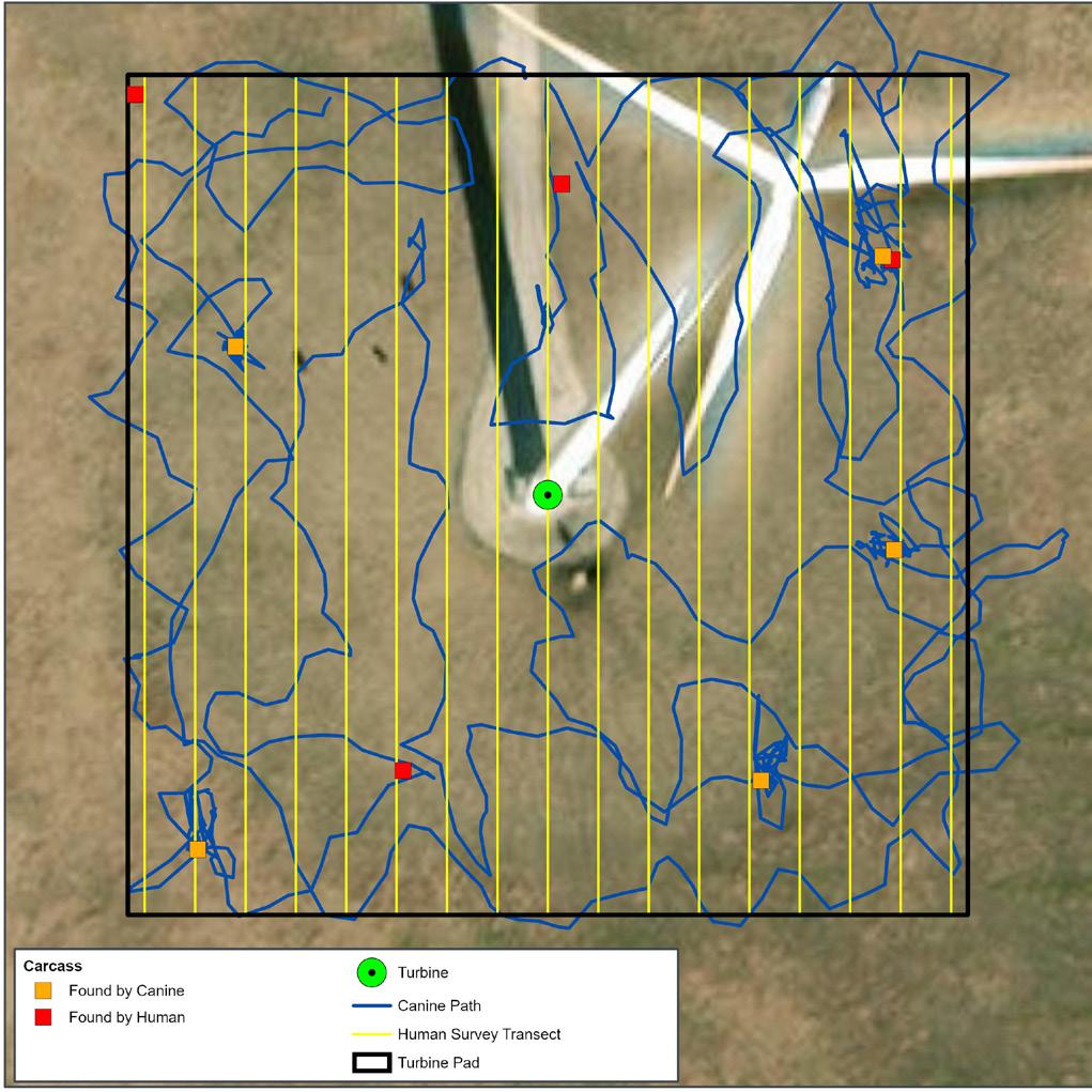
Searching by smell rather than sight alone allows Moxie (blue) to cover the same area more quickly than the human surveyor’s transect paths (yellow) evenly spaced across the survey plot. Moxie completed this search 20 minutes faster than the human surveyor.
Goggles protect Moxie’s eyes from irritants and impacts when moving quickly through dense vegetation. Playtime with a sheepskin toy is her reward after each find.
Searching by smell rather than sight alone allows Moxie (blue) to cover the same area more quickly than the human surveyor’s transect paths (yellow) evenly spaced across the survey plot. Moxie completed this search 20 minutes faster than the human surveyor.
TOC
To alert Allison of a find, Moxie sits facing the carcass until she is released and rewarded.
fatality that was almost completely buried by a previous ant infestation as well as a piece of bat wing and tuft of fur smaller than a pinky.

Allison’s trials clearly demonstrated significant advantages of canine-handler survey teams over their human counterparts, echoing other studies and papers published in recent years. Because of the efficiency and efficacy improvements, a caninehandler team also provides a cost-effective solution for clients.
“SWCA has been using canine-searcher teams very effectively on our projects in Hawaii, where they are up to six times more efficient than humans alone in difficult-to-search volcanic environments,” said Ann Widmer, an ecologist in SWCA’s Denver office. “However, SWCA hasn’t had this capability in the mainland U.S. until now. Many of our wind energy clients are interested in preserving existing land uses beneath the turbines, but it is sometimes necessary to mow the vegetation grown for crops or grown to support livestock in order to make the area searchable by humans. With a well-trained dog on the team, mowing may not be necessary. Likewise, many of our clients are required to monitor large areas for eagle fatalities. Dogs are perfect for this task—covering more area in less time and locating targets with an exceptionally high degree of precision. We’re continually identifying new applications where dogs may be a real asset.”


Avian and bat fatality monitoring is not the only type of environmental survey where detection dogs could be of use to SWCA’s clients. Allison says environmental detection canine teams have been conducting surveys all over the world to prevent the spread of invasive species and to protect threatened and endangered species like the Wyoming toad, giant garter snake, black-footed ferret, ornate box turtles, Pacific pocket mouse, and Kemp’s ridley sea turtle nests.
Elsewhere in the U.S., dogs have been used to find Oregon silverspot butterfly larvae that are smaller than a grain of rice and have not been detected in the past 40 years of humanconducted surveys. They have also recently been used to find floating scat samples (which only float for a short period of time) of declining Southern resident orca whale populations by sniffing from the bow of a boat.
Detection dogs are already making a difference in environmental research and conservation in amazing and unexpected ways. With support from SWCA, Allison is planning additional canine studies, using sound science to find creative solutions to better protect threatened and endangered species, eradicate invasive species, and mitigate negative impacts to clients’ projects and bottom line. For more information, please contact Allison Locatell .
efficiency efficiency %84.6 % 48.7
MOXIE 17 of 19 bats found 16 of 20 quail found 20 minutes average per turbine HUMAN 9 of 19 bats found 10 of 20 quail found 30 minutes average per turbine efficiency efficiency % 53.2 % 21.5
MOXIE 18 of 39 bats found 24 of 40 quail found 26 minutes average per turbine HUMAN 6 of 39 bats found 11 of 40 quail found 42 minutes average per turbine TOC
Moxie’s most difficult finds included a previously buried bird carcass and small pieces of bat wing Moxie helping out
TRIAL SITE 1
TRIAL SITE 2
-Ann Widmer, an ecologist at SWCA


SWCA has been using canine-searcher teams very effectively on our projects in Hawaii, where they are up to six times more efficient than humans alone in difficult-to-search volcanic environments.
TOC
Moxie wears a GPS collar to record her search path at each turbine, allowing Allison to monitor survey coverage in real time
A TALE OF TWO RIVERS
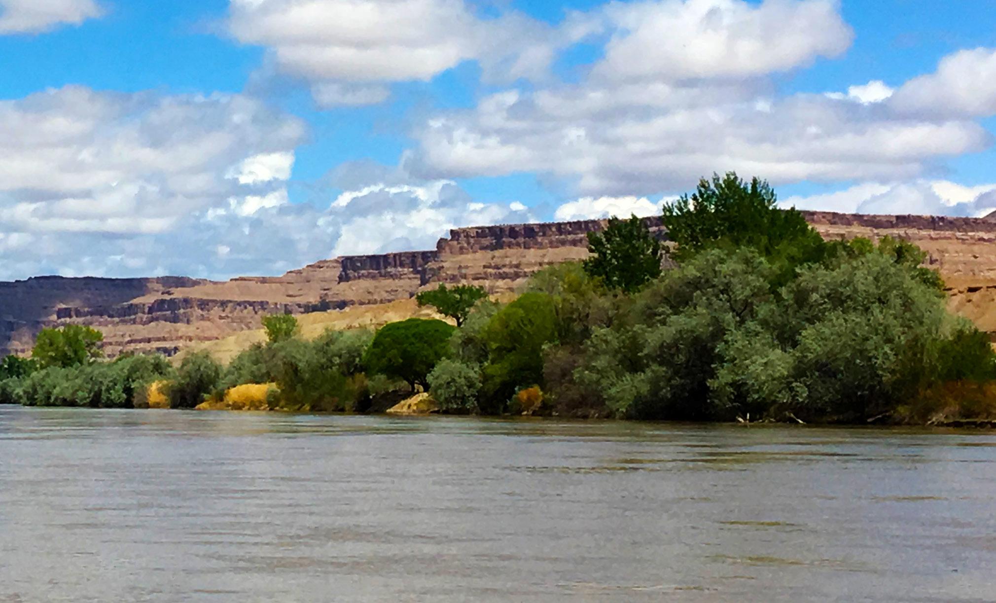
Rivers are the arteries of our earth’s landscape. Nothing matches a river’s abilities to connect our places and spaces and sustain life in, alongside, and even miles away from its course. A river will travel along the path of least resistance, beginning at a high point known as the headwater and ending at its mouth. Depending on its elevation, age, geology, and other factors, a river can make a mad dash through the landscape, leaving behind canyons and waterfalls, or it may saunter across the land creating wide floodplains and marshes along its edges.
The world’s inhabitants gravitate toward rivers and use them to serve their needs. Humans have established communities on their banks; traveled on them; harvested food from them; dammed them for


hydropower; and altered their courses and changed their natural flows to support agriculture, urban development, and other needs. Humankind has had an enormous effect on rivers, but we can move forward, lessons learned, to ensure that rivers remain flourishing, productive, and inspiring places for generations to come.
How do we manage rivers as functioning, sustainable ecosystems while still supporting human needs? It is a complicated question without easy answers. One approach is to develop comprehensive management plans (CMPs) that guide land managers and the public. SWCA recently had the opportunity to develop CMPs for segments of two of the West’s most important rivers—the Green and the Colorado.
Comprehensive management planning can benefit ecosystems and communities while encouraging agency collaboration.
TOC
The Colorado River
The Put-In
The Utah Division of Forestry, Fire & State Lands (FFSL) approached SWCA with a challenge: How could FFSL balance the protection of Public Trust resources (navigation, fish and wildlife habitat, aquatic beauty, public recreation, and water quality) with the proposed human uses of the Green and Colorado Rivers?
To address this challenge, FFSL trusted SWCA to develop Utah’s first-ever CMPs for sovereign land segments of these two essential waterways. The CMPs would describe the existing condition of the rivers’ resources and provide a management framework to help the agency fulfill its responsibilities. In addition, the CMPs would provide consistent, clear permitting processes and requirements and outline best management practices for implementing any authorized projects. Developing the CMPs required an extensive outreach process that involved five stakeholder groups: counties, the public, federal agencies, tribes, and specific organizations or people representing, for example, recreation and agriculture. These stakeholders’ decisions and actions, both large and small, influence land management and the resource issues at the heart of the plans. Multiple meetings with these groups ensured broad input and buy-in.
FIRST OF THEIR KIND
Background

The Utah State Legislature has designated FFSL as the executive authority for the management of sovereign lands in Utah, including the beds and banks of the Green and Colorado Rivers. Learn more about the history and approach of FFSL in the full version online.

The Green and Colorado Rivers CMPs represent a few firsts, both regionally and nationally. Their development has increased the Utah public’s awareness of FFSL’s jurisdiction and management authority and, because many of the plans’ goals and objectives are geared toward cooperative efforts, they have improved coordination among the many agencies responsible for the rivers and their resources. The plans—especially the Colorado River CMP— are significant nationally because the Colorado River system supplies water for agriculture, industry, and municipalities throughout the Western United States. The Colorado River generates hydropower; supports a diversity of fish, wildlife, and other habitats; and offers recreation for locals and tourists from around the world. Because it is one of the most legislated, debated, and litigated rivers in the world, cooperative and coordinated management along the entire water course, including Utah, is essential for maintaining its health.

TOC
Main Stem
The CMPs present existing information, current scientific studies, available land use data, and management goals and objectives in reader-friendly text and illustrations. FFSL classifies sovereign lands based on use classes provided in Utah Administrative Code R652-70-200. SWCA worked closely with FFSL to review each river and assign use classes to help guide decision-making. Use class maps can be viewed in more detail in a GIS data viewer.
A proposed action matrix shows common activities that require FFSL authorization and in which use class those activities are allowable, potentially allowable, or not allowable.
Tributaries
The complete CMP package includes interactive Esri Story Maps and an innovative GIS data viewer for the public. Many of today’s readers prefer not to page through a plan, even one with navigation links. These readers can see and explore each river via an interactive Esri Story Map organized with tabs that align with the CMPs’ content, sidebars with text and graphics depicting resource information and management goals and objectives, and related data layers. Users can turn certain data layers on and off and see the resources that matter to them. A municipality, for example, can combine authorization locations with river use classes to plan a utility crossing. Boaters can layer access locations and navigational hazards to prepare for a float trip. Researchers can select wildlife and habitat layers to understand the river’s ecology.
Looking Downriver
The CMPs are essential resources for FFSL and river stakeholders in daily operations, decision-making, and future planning. Each CMP provides a onestop shop for accessing current resource information, viewing river classifications and allowable uses, referencing management goals and objectives, and reviewing best management practices. In addition, the CMPs provide a clear picture of FFSL’s jurisdiction and authority and how the agency’s role relates to the roles of other agencies managing the river.


Perhaps the most beneficial achievement of the CMPs has been the strengthening of partnerships with other managing agencies and entities. Because multiple agencies and entities have jurisdiction over the rivers and their resources, holistic management has


The Green River TOC
always been a challenge. At the outset of the CMP development process, FFSL established a planning team of state agencies to provide data, technical information, insight into management and jurisdictional roles, and oversight of CMP content throughout the process. In addition, the public outreach process included multiple meetings with counties, federal agencies, and tribes. By working with the planning team and other managing partners, opportunities for holistic management were identified and included as goals and objectives, and FFSL’s role on the Green and Colorado Rivers was elevated.
The CMPs’ many other benefits are as follows:
The public now has an enhanced understanding of the rivers’ current conditions and FFSL’s direction, responsibilities, and goals for managing sovereign lands. Recreationists can more easily identify recreation opportunities and access points.


Potential permittees better understand FFSL’s management authority, permit requirements, and processes; the need for appropriate project designs that align with management goals; and best management practices. The types of projects allowed and areas where projects can be implemented are outlined in the CMPs.
Adjacent landowners are more aware of their potential to positively or negatively affect the river and can better work with FFSL to protect it.

Local communities’ concerns were heard, and potential solutions to issues were developed through management goals and objectives in the CMPs. This has led to enhanced trust and communication with this important stakeholder group.
Future recreation users will experience fewer conflicts on the rivers because the CMPs identify the need for a recreation resource management plan in heavily used river segments of both rivers. For more information, please contact Gretchen Semerad and Linda Tucker Burfitt
Deep Connections
SWCA’s desire to contribute to the success of the Green and Colorado Rivers CMPs runs deep. We have strong personal connections to these majestic rivers. Learn more about how the roots of SWCA connect in the full version online.
Green River Plans
Click these links for more information on the CMPs, Esri Story Maps, and GIS data viewers Colorado River Plans TOC
PARTING SHOT
Ragsdale Creek (after restoration construction) with stream structures to slow down water flow and native grasses and trees planted along the banks to help stabilize the stream. Read more in “Water, Water Everywhere Stream and Wetland Restoration in North Texas”, page 4.
The Wire is published by SWCA, Incorporated. For editorial comments or questions: email us at thewire@swca.com; or write to SWCA Environmental Consultants, 20 E. Thomas Rd., Suite 1700, Phoenix, AZ 85012

TOC
