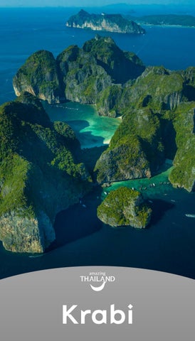

Krabi
Krabi
Krabi, the liveable city, friendly people
Krabi was established around 1872 during the reign of King Rama V the Great, who graciously raised its status to be “Mueang Pakasai”, which means the source of swords and bestowed the name “Mueang Krabi”.
When it was announced as a city, a government office was established at Tambon Krabi Yai (Ban Talat Kao). Then, in 1875, the King graciously separated the city of Krabi from the administration of Nakhon Si Thammarat to be a city directly under Bangkok. In 1900, the city was moved to Tambon Pak Nam. Near the mouth of the bay is a deep trench, so large ships could easily dock, which is where the city hall has been located until now.
Krabi is a province located on the Andaman Sea, rich in natural tourism resources, and ancient cultural heritage. There is an integration of the lives of the people of different nationalities, religions, and beliefs that are harmoniously different. There are also mountains, mangrove forests, waterfalls, marine national parks that are world-famous tourist attractions, including various forms of tourism activities to respond to tourists of all age groups.
Krabi Map
Plai Phraya
Khao Phanom
Lam Thap
Khlong Thom
Ko Lanta
Nuea Khlong
Mueang Krabi
Ko Ngai
เKo Lanta Yai
Ko Phi Phi Le
Ko Phi Phi Don
Ko Jum
Ko Si Bo Ya
Ko Lanta Noi
Ko Rok Nok
Ko Rok Nai
Ao Luek

Khao Khanap Nam Mueang, Krabi


Khao Khanap Nam
Mueang, Krabi
The symbol of Krabi town, are two hills towering in front of the city and are about 100 metres high flanking the Krabi River. Around Khao Khanap Nam, there is a staircase leading up to a cave, which inside, there are stalagmites and stalactites. Many ancient human skeletons were also discovered. They are thought to be the skeletons of a group of people who settled there but died in sudden flooding. There is also a corner replicating the Japanese soldiers’ shelters of the past. Tourists can visit by renting a long-tail boat at the Chao Fa Pier (black crab sculpture area) that takes about 15 minutes per trip.

Ko Klang community
Mueang, Krabi

Ko Klang community
Mueang, Krabi
Ko Klang community is a small island in the middle of the Krabi River surrounded by fertile mangrove forest at the mouth of the river. It is full of charm of the simple community way of life and still maintains the local identity. The villagers on the island are Muslims; therefore, it is forbidden to bring pigs and dogs onto the island.
Tourism activities on Ko Klang include exploring the atmosphere and lifestyle of the villagers around the island (walking, cycling, renting a motorcycle and driving, or using a tricycle with a sidecar for touring), see demonstrations from different groups of professions, the organic farming group, Sangyod rice farming, demonstration group for making model boats, batik making group, etc. There is accommodation in both resorts and homestays, as well as local seafood restaurants with reasonable prices. Tourists can take a boat across to the island both in the morning, evening, and can stay overnight.
Getting there: Tourists can take a long-tail boat across from Krabi town. Board the boat at Chao Fa Pier to Tha Hin Pier (Ko Klang), which takes about 15 minutes, or take a boat from Tara Park Pier to the Tha Le Pier (Ko Klang) that takes about 10 minutes. Both ports have boats available from morning to evening.


Ao Nang Mueang, Krabi


Ao Nang
Mueang, Krabi
Located to the southern part of the Hat Noppharat Thara National Park Headquarters. It is the most popular beach in Krabi, and a source of a variety of amenities including accommodation, restaurants, souvenir shops, tour companies, and a long-tail boat service point to Railay Beach and other islands in Krabi.
The distinctive identity of Ao Nang is in the southern part of the beach. There is a rocky mountain line between Ao Nang and Tonsai Bay, which has beautiful scenery, especially in the evening. This is another stunning sunset viewpoint in Krabi.

Railay Beach
Mueang, Krabi

Railay Beach
Mueang, Krabi
Railay Beach is an outstanding beach with beautiful features with limestone cliffs. The beach is divided into 3 parts: Railay Beach Westthat is surrounded by limestone cliffs, where it is possible to swim and also a point to watch the sunset. Railay Beach East has a famous activity that is popular with foreign tourists, which is rock climbing. This is because at the end of the beach, there is a limestone cliff with a height suitable for rock climbing. Phra Nang Cave Beach, which is the location of Phra Nang Cave. Inside there is a shrine of Phra Nang that sailors in this area respect and worship. When entering the cave and looking out, tourists will see the mouth of the cave with stalactites descending to form an attractive chandelier, and it is also another beautiful sunset viewpoint.
Getting there: Take a passenger boat (Hua Tong boat) at Ao Nang and Noppharat Thara Beaches. The fare is 100 Baht/ person/trip, and the journey takes about 20 minutes. Boats are available all day morning-evening.

Ko Poda Mueang, Krabi


Ko Poda
Mueang, Krabi
Ko Poda is to the south of Ao Nang 8 kilometres from the coast. It is unique in that it has a small island. The island looks like a sailboat located in front of the beach. Ko Poda is surrounded by beaches on 3 sides except the west side, which is the side that receives windy waves and is a high rocky cliff. There are white sandy beaches around the island and clear water that is suitable for swimming. The island’s coastline has a variety of intact coral reefs. Therefore, it is an attraction for tourists to visit almost all-year round.
Getting there: A Hua Tong boat can be rented from the Ao Nang area, or buy a day or half-day tour package from a travel agency in Krabi, which often organises tour programmes for 4 islands on the same route: Ko Poda, Thale Waek (Ko Kai, Ko Thap, and Ko Mo), and Railay Beach. It takes about 30 minutes from Ao Nang.
For further details contact, the Ao Nang Boat Service Co-operative Tel. 0 7566 1131


Thale Waek Mueang, Krabi

Thale Waek
Mueang, Krabi
Thale Waek is near Ko Poda. It is a natural phenomenon that occurs when the sea level is at the lowest each day. It is like the sea has split open until it has become a white sand dune, and it connects 3 islands: Ko Kai, Ko Thap, and Ko Mo. The time that tourists have the opportunity to see Thale Waek will be a period of 5 days before and after the 15th day of the waxing moon. The tourist season is November-early May of every year.
Getting there: A Hua Tong boat can be rented from the Ao Nang area, or buy a day or half-day tour package from a travel agency in Krabi, which often organises tour programmes for 4 islands on the same route: Ko Poda, Thale Waek (Ko Kai, Ko Thap, and Ko Mo), and Railay Beach. It takes about 30 minutes from Ao Nang.
For further details contact, the Ao Nang Boat Service Co-operative Tel. 0 7566 1131

Ko
Phi Phi Don Mueang, Krabi

Ko Phi Phi Don
Mueang, Krabi
Located in the Hat Noppharat Thara-Muko Phi Phi National Park. The highlight of the island is the twin bays of Tonsai Beach and Loh Dalum Beach that look like the letter C facing each other. It is the most beautiful beach in the world. Tonsai Bay is the location of the island’s main port and is also the hub for accommodation, restaurants, and various amenities. From Tonsai Bay, there is a path to Loh Dalum Bay, which is a beautiful cove with clear water suitable for swimming. There are also other interesting points on Ko Phi Phi Don, e.g., Ko Phi Phi Don Viewpoint, Loh Ba Kao Bay, Rantee Bay, Wang Long Bay, and Laem Tong.
Because it is located in the Hat Noppharat Thara-Muko Phi Phi National Park, there is a fee to enter the Park. adults 400 Baht; children 200 Baht. It is recommended to keep the Park entrance ticket with you because there may be an inspection by the Park officials in both the Phi Phi Don and Phi Phi Le areas.
For further details contact, Tel. 0 7566 1145 or www.dnp.go.th
Getting there: There is a speedboat service to and from Ko Phi Phi Don, or boats depart from Khlong Jilad Pier and Krabi Marina Pier in Krabi town. The trip takes about 1 hour, and the fare is 450-500 Baht/seat. There is a passenger boat leaving Rassada Pier, Phuket province to Phi Phi Don as well.


Ko Phi Phi Le Mueang, Krabi

Ko Phi Phi Le
Mueang, Krabi
Located in the Hat Noppharat Thara-Muko Phi Phi National Park about 2 kilometres from Ko Phi Phi Don. It has an area covering 6.6 square kilometres. The island’s features are a limestone mountain with a steep cliff perpendicular to the sea, as well as beautiful and world-famous coves, e.g.:
Pi Leh Bay or Lagoon is a large cove with a gorge at the entrance. It is surrounded by limestone hills that resemble emerald green sea halls.
Loh Samah Bay is one of the most beautiful diving spots of Ko Phi Phi Le. There is a pile of coral reefs, colourful anemones, including a large number of fish.
Maya Bay is a famous bay of Ko Phi Phi Le. It is surroudne by mountains and has a white sandy beach and emerald green sea.
Viking Cave: Inside the cave, historical paintings were found of an elephant and different kinds of boats. It was assumed that these paintings were done by sailors. This is because this was a navigation route or a point where ships could stop for shelter from the monsoon winds, unload goods, or repair ships. At preent, it is now a bird’s nest concession area.
Getting there: Tourists can charter a Hua Tong boat from Ko Phi Phi Don, or buy a day tour package from Krabi and Phuket. The fee to enter the Park: adults 400 Baht; children 200 Baht. It is recommended to keep the Park entrance ticket with you because there may be an inspection by the Park officials in both the Phi Phi Don and Phi Phi Le areas.
For further details contact, Tel. 0 7566 1145 or www.dnp.go.th


Nong Thale Mueang, Krabi

Nong Thale
Mueang, Krabi
Located at Ban Nong Thale, Tambon Nong Thale. It is large freshwater swamp surrounded by limestone mountains. Within the swamp, there is an island in the middle of the water and a variety of local plants to study. The recommended time to visit is early in the morning at sunrise. This is because the sunlight falling on the mist that floats above the water’s surface in the morning is a beautiful sight. Tourists can take a boat cruise of the Nong Thale community or take a kayak to see the surrounding nature.
During March to April, there will be red club flowers falling on the rocks along the marsh making the scenery of Nong Thale even more beautiful. As such, it is a popular spot for taking photos.
For further details contact, the Ban Nong Thale Tourism Community Tel. 06 1280 1014
Khlong Nam Sai and Khlong Rut Mueang, Krabi

Khlong Nam Sai and Khlong Rut
Mueang, Krabi
Located in the area of Ban Laem Son, Tambon Nong Thale. Khlong Nam Sai is a small freshwater canal. The water source is caused by natural springs beneath the soil surface in the midst of a quiet community forest. The water in the canal is very clear, especially when the sunlight is reflected, the water will be emerald green. At some points, the sand can be clearly seen under the water, and it is also possible to swim at some points.
The downstream of Khlong Nam Sai connects to Khlong Rut, which is another popular spot for tourists and locals to swim. To visit and go swimming at Khlong Nam Sai and Khlong Rut, the most convenient and enjoyable way is to kayak to the point of the watershed. As such, there are several kayak rental points in the Ban Laem Som area.

Wat Tham Suea
Mueang, Krabi

Wat Tham Suea
Mueang, Krabi
Located on Khao Kaeo, Tambon Krabi Noi. Originally, it was “Na Ching Monastery”, a place for practicing Dharma and meditation. Later it was renamed Wat Tham Suea, and the reason for being named this was because tigers used to live in the cave in that area, and inside the cave there is a natural stone in the shape of a tiger’s paw. The general natural condition is a forest and many small caves.
The highlight of the temple is the Phrathat chedi, replica of the Buddha’s Footprint, and a large Buddha image in the posture of meditation, which is enshrined on the top of Khao Kaeo that is about 600 metres above sea level in height. There is a stairway with 1,237 steps for walking up to worship. In addition, at the top of Khao Kaeo, visitors can see a 360-degree view of Krabi town, which is surrounded by beautiful, strangely shaped mountains. It is also a point to watch the sunrise. During the months of September-January, there is a chance to see the sea of mist in the morning as well.

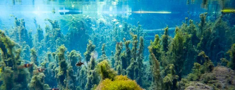
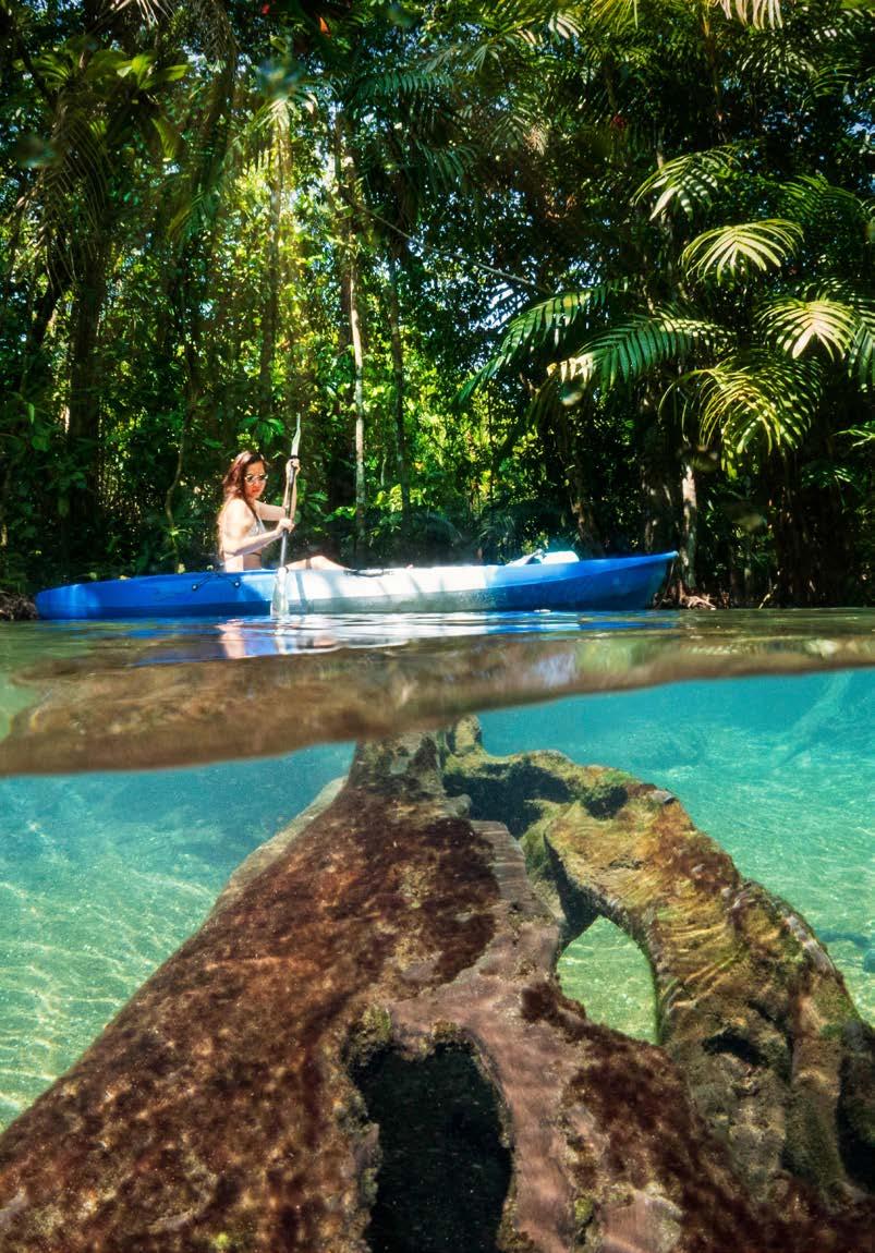
Tha Pom, Khlong Song Nam
Mueang, Krabi
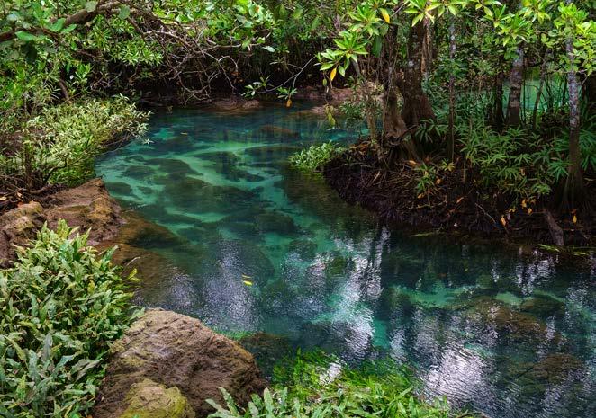
Tha Pom, Khlong Song Nam
Mueang, Krabi
Located in Tambon Khao Khram. Khlong Tha Pom has its source from the swamp forest on Khao Chong Phra Kaeo. The end of the water in the canal flows into the Andaman Sea. It is a canal with special characteristics. When the sea level rises, the water in the canal is brackish and has a somewhat cloudy blue colour, but when the sea water recedes, the water in the canal becomes fresh water and has a beautiful clear turquoise colour. Hence, it was called Khlong Song Nam (two-coloured water canal). There is also a walkway with a 700-metre-long wooden bridge to study the nature. On both sides of the path is moist evergreen forest, swamp, and mangrove forest. In some spots, it is possible to swim, and canoeing services are available to paddle around in the canals.
Open everyday between from 08:00- 17:30 Hrs.
Entrance fee: Adults 100 Baht; children 50 Baht. For further details contact, the Khao Khram Subdistrict Administrative Organisation Tel. 0 7569 4165, 0 7569 4198


Ko Hong (Ko Laopilae) and
Ko Hong Lagoon (Thale Nai)
Ao Luek, Krabi

Ko Hong (Ko Laopilae) and Ko Hong Lagoon (Thale Nai)
Ao Luek, Krabi
Ko Hong (Ko Laopilae) and Ko Hong Lagoon (Thale Nai) are a part of Muko Hong, Than Bok Khorani National Park. The island’s feature is a limestone mountain. In front of the island is a curved sandy beach that looks like a flying bird with fine white sand and emerald green water, which is very beautiful and clear. At one end of the beach, there is a walkway with 419 iron stairs and from the top of the mountain, there is a 360-degree panorama. The beach of Ko Hong can be seen below, including various islands in the waters of Krabi and Phang-nga provinces.
The other side of Ko Hong has some interesting sites, e.g., Ko Hong Lagoon (Thale Nai), which looks like a wide hall in the middle of the sea surrounded by high cliffs like a volcanic crater. Inside the lagoon, there is emerald green water. It is possible to moor boats and go swimming, Boats can enter and exit only one channel when the sea level rises.
Getting there: A one-day tour package can be purchased from Krabi town, Ao Nang, or from Phang-nga (because the maritime territories are connected), or hire a Hua Tong boat from Ao Nang or Noppharat Thara Beach that takes about 45 minutes-1 hour.
The fee to enter the Park: Adults 300 Baht; children 100 Baht. The beach area of Ko Hong has a visitor centre, welfare shop, and restrooms.

Ko Lao Lading and Ko Phak Bia

Ko Lao Lading and Ko Phak Bia
Ao Luek, Krabi
Ko Lao Lading and Ko Phak Bia are a part of Muko Hong, Than Bok Khorani National Park. Ko Lao Lading: In front of the island is a beautiful curved beach with clear water where it is possible to swim. It is also a mooring point for tourist boats. When standing on the island and looking out onto the beach, a beautiful view of the beach with boats lined up and surrounded by rock cliffs can be seen. It is also a popular spot that tourists like to take photos.
Ko Phak Bia has a distinctive identity. When the sea water recedes, a sandbar will appear similar to the sea being separated that visitors canwalk across to a small island on the other side, which is also called Ko Phak Bia.
Getting there: A one-day tour package can be purchased from Krabi town, Ao Nang, or from Phang-nga (because the maritime territories are connected), or hire a Hua Tong boat from Ao Nang or Noppharat Thara Beach that takes about 45 minutes-1 hour.

Ban Laem Sak Tourism Community Ao Luek, Krabi

Ban Laem Sak Tourism Community
Ao Luek, Krabi
Located in Tambon Laem Sak and is a community that combines 3 cultures: Buddhist, Chinese, and Muslim. It is outstanding in terms of atural attractions. The sea that surrounds Laem Sak is called “Thale Nai” because there are mountains in the middle of the sea that surround another long line to protect the monsoon and windy waves on all sides. This allows visitors to come to Ban Laem Sak all-year round.
Interesting tourism activities include experiencing the way of life of the villagers, local fishing, watching fish farming in the cages, lobster farming, cultivation of grape algae, walking through the mangrove forest at Khao Chang Mop, taking a boat trip to Chao Le Cave and different islands, trying shrimp paste fried rice that is the famous food of the community, and supporting and trying on the Baba Yaya costume that is the local dress of the villagers. There are both resort and homestay accommodation on the island for tourists. For further details contact, Tel. 089 997 8915

Khlong Thom Waterfall
Khlong Thom, Krabi
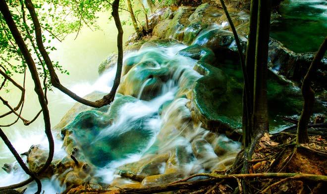
Khlong Thom Waterfall
Khlong Thom, Krabi
Located at Ban Bang Khram, Tambon Khlong Thom. It is one of the many hot springs scattered throughout the area. The temperature of the waterfall is about 40-50 degrees Celsius. It is hot water that seeps up from the soil surface, which is covered with shady forest. The stream flows together along the slope of the area. Some periods are smoky and thick layers of natural limestone are covered, thus creating strangely beautiful scenery. In particular, in the area where the hot water stream flows into Khlong Thom, the level is reduced to look like a small waterfall. Nearby there is also a hot spring where tourists can soak in mineral water.
Opens everyday between 08:30-18:00 Hrs.
Entrance fee: Adults 160 Baht; children 80 Baht.

Sa Morakot (Emerald Pool)
Khlong Thom, Krabi


Sa Morakot
(Emerald Pool)
Khlong Thom, Krabi
Located in the area of the Khao Phra-Bang Khram Wildlife Sanctuary, Tambon Khlong Thom Nuea. There is a nature study path for a distance of 1,400 metres. The pool’s origin comes from warm water streams in the lowland forests of the South. The features comprise 3 pools: Sa Kaeo is a pool that flows from the Emerald Pool. The water is clear but cannot swim here. Sa Morakot looks like an emerald green pool that comes from warm water. The temperature is about 30-50 degrees Celsius. The surrounding area is a shady forest where it is possible to swim. Sa Namphut is the origin of the Emerald Pool. It has a beautiful, clear blue appearance and is 600 metres from the Emerald Pool. It is also the habitat of the black-bellied tarot, a rare and endangered wildlife species in Thailand.
Opens everyday between 08:30-17:00 Hrs.
Entrance fee: Adults 200 Baht; children 100 Baht.


Ko Lanta
Ko Lanta, Krabi


Ko Lanta
Ko Lanta, Krabi
Ko Lanta is divided into Ko Lanta Noi and Ko Lanta Yai. The island’s business centre is at Saladan Pier on Ko Lanta Yai. The Sriraya community on the east side of the island is an old community. The western side of Ko Lanta Yai is lined with beaches, e.g., Kho Kwang Beach, Loh Bara Beach, Phra Ae Beach, Khlong Khong Beach, Khlong Nin Beach, and Ba Kantiang Beach. Also, Siri Lanta Bridge connects Ko Lanta Yai and Ko Lanta Noi. In addition, there is Laem Tanot, a promontory protruding south of Ko Lanta Yai, which is the location of a lighthouse and a beautiful sunset viewpoint. At the end of the cape is Ko Mo, a deep-water diving spot.
Getting there: Tourists can take a car onto the ferry at the Ban Hua Hin-Ban Khlong Mak Car Ferry Terminal (Ko Lanta Noi). Then, use the Siri Lanta Bridge to cross to Ko Lanta Yai. The car ferry is open for service 06.00 - 22.00 Hrs. Fare: 20 Baht/person; vehicle: 100 Baht.


Ko Lanta, Krabi
Ko Ngai

Ko Lanta, Krabi
Located in the area between Krabi and Trang provinces and in Muko Lanta National Park. On the east side of the island, there is a long white sandy beach. There is some private accommodation available but notmuch. As such, it is recommended to reserve in advance of the travel date.
On the western side of the island is a high mountain range, and in the south of the island is the location of the National Park Protection Unit. Around the island there are beautiful coral reefs suitable for diving.
Getting there: It is possible to travel day, night, and overnight. The most convenient way is to purchase a day tour package with the route of Ko Ngai, Ko Chuak, Ko Ma, Morakot Cave, or rent a boat from Pak Meng Pier, Trang province, which is the most convenient and closest port for travelling to Ko Ngai.
Ko Ngai

Ko Rok
Ko Lanta, Krabi


Ko Rok
Ko Lanta, Krabi
Located in the area between Krabi and Trang provinces and in Muko Lanta National Park. It is divided into Ko Rok Nai and Ko Rok Nok. The sides facing each other are a sandy beach separated by shallow sea trenches. The distance between the two islands is about 250 metres. In front of Ko Rok Nok, there is a fine white sandy beach stretching from the head to the end of the island.
The highlight of Ko Rok is the coral reefs around the island and the canals that are still intact. As such, it is a paradise for divers of both deep and shallow water. The main dive sites of Ko Rok are at the beach
in front of Ko Rok Nok and in the trench area between Ko Yao all the way to the sea in front of the shrine. There are also the Hin Muang and Hin Daeng Mounds, where whale sharks are frequently reported in the area. This is another popular scuba diving spot on the Andaman side.
Getting there: It is possible to travel day, night, and stay overnight. The most convenient way is to purchase a one-day tour package from Ko Lanta Yai, which offers tours to Ko Rok every day. Tourists can also buy a day tour package or rent a boat from Pak Meng Pier, Trang Province. It takes about 1 hour to get to Ko Rok.
The fee to enter the Park. Adults 400 Baht; children 200 Baht. There is a camping site for tourists.
For further details contact, Tel. 0 7565 6576 or www.dnp.go.th

TAT CONTACT CENTER
TOURISM AUTHORITY OF THAILAND (HEADQUARTERS)
1600 New Phetchaburi Road, Makkasan, Ratchathewi, Bangkok 10400
Tel. 1672 and 0 2250 5500
Fax. 0 2253 7440
Website: www.tourismthailand.org
E-mail: info@tat.or.th
Open every day from 08.30 to 16.30 Hrs.
Suvarnabhumi Airport
Gate 3, Level 2, Arrivals Hall
Tel. 0 2134 0040
Open 24 hours daily
Don Mueang International Airport
Gate 2, Level 1, Arrivals Hall (Terminal 1)
Tel. 0 2504 4301
Open 24 hours daily.
TAT Krabi Office
292 Maharat Road, Amphoe Mueang, Krabi 81000
Tel. 0 7562 2163; 0 7561 2811-2
Fax. 0 7562 2164
Email: tatkrabi@tat.or.th
Responsible for tourism in Krabi only