5 minute read
The Future of Emergency Response: Merging


Laser Rangefinder Technology, Drone Innovation, and the Accuracy of what3words
DroneControl is Empowering Emergency Response and Synergising Drone Technology with Laser Rangefinders and what3words Geolocation System
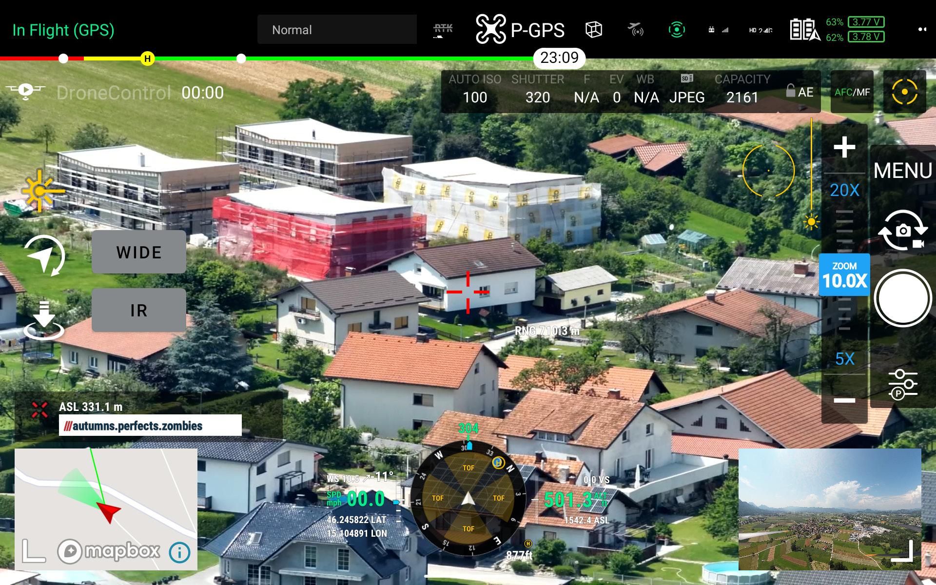
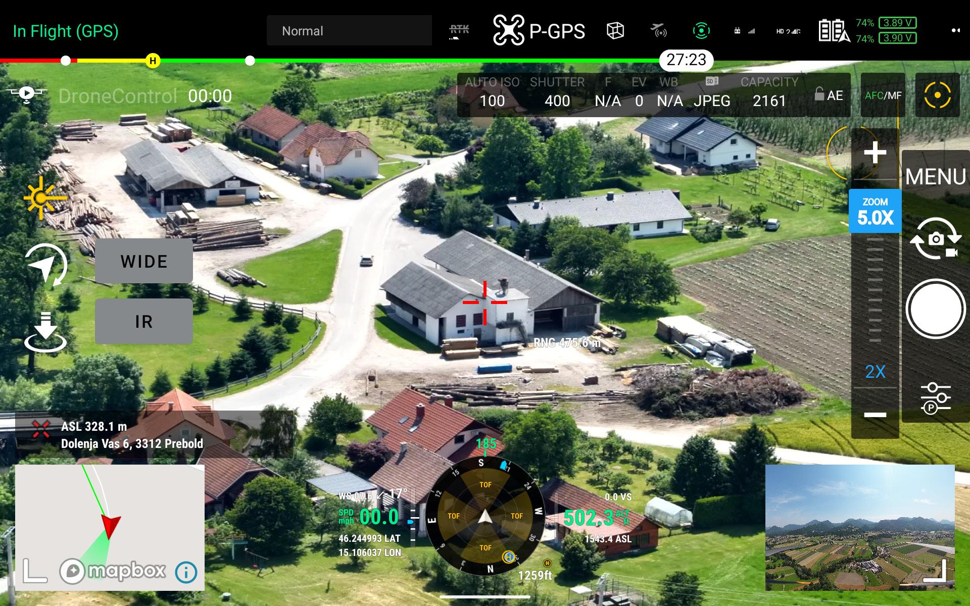
DroneControl FirstResponder utilizes the laser range finder to pinpoint the what3words location from up to 1.2km away.
In the dynamic and critically important world of emergency services, the difference between success and failurelife and death - often hinges on one critical factor: location. Traditional methods of conveying geographical coordinates have been subject to human error, inherent communication delays, and interpretation inconsistencies. The advent of advanced technologies, however, is set to redefine this landscape. The ingenious integration of drone technology, laser rangefinders, and the groundbreaking geolocation system, what3words, has created a powerful synergy that promises to revolutionise emergency response.
Before delving into the specifics of this innovative convergence, it's essential to understand what3words. This remarkable global addressing system has effectively divided the world into a grid of 3m x 3m squares, each assigned a unique combination of three simple, memorable words. It's as accurate as GPS coordinates, but significantly easier to share and comprehend, which makes it an invaluable tool for emergency services.
So how does drone technology fit into this picture? Drones equipped with laser rangefinder technology have the capability to ascertain the exact distance between the drone and the target location.
By merging this technology with the pinpoint accuracy of what3words and Mapbox's postal address systems, DroneControl's pioneering software is able to deliver real-time, highly precise location data to emergency service teams. This groundbreaking feature ensures that every second counts when lives are at stake, potentially minimising response times and enhancing rescue operations.
Patrick Arbuthnott
-
Head of Technology
Partnerships -
what3words
, emphasises the transformative impact of this integration:
"Emergency services across the UK use what3words everyday to share and communicate precise locations for a wide range of incidents. Our integration within DroneControl's FirstResponder means what3words addresses can be displayed live on screen, helping to improve the way teams identify exact locations in timecritical moments. The ability to pass a location to the accuracy of a 3m x 3m square using just three words over radio or text, enables an effective multi-agency response on the ground to the exact same point, smoothly and quickly."
To fully grasp the power of this innovation, imagine a scenario where emergency responders receive exact location coordinates in just a few seconds, without any ambiguity or delays, even from distances of up to 1,200 meters. The DroneControl software eliminates the requirement for lengthy communication exchanges and minimises the risk of misinterpretation that can occur when coordinates are relayed verbally.
Ben Shirley, Training Development Manager at Heliguy, is particularly enthusiastic about this innovative step:
"The coordination and transmission of critical information between first responders can vastly influence the efficiency of a response. DCFR seamlessly integrates W3W location data to enable the swift and precise positioning of the drone and coordination between ground responders, shifting the paradigm from converting less precise forms of location data. This has been a longstanding and widely requested function, so we're excited to see this appear in the comprehensive functionality of DCFR".
But the customisation of DroneControl FirstResponder for the emergency services doesn't stop with laser rangefinder integration. It also offers real-time, secure streaming and audio feeds, remote flight and camera control, an app layout that mirrors DJI Pilot 2, and the enhancement of situational awareness. These features collectively improve incident response and crew safety. The potential applications of this technology extend beyond emergency services to other sectors such as Architecture, Engineering, Construction (AEC), and security.
Secure live streaming and remote control can play a pivotal role in drone-based emergency response.
In emergency situations, information is key, and the speed and accuracy of its relay can drastically impact the outcome. Secure live streaming allows incident command centres to view the situation in real-time, offering a comprehensive understanding of the scene that would be impossible from ground level alone. This bird's-eye view can inform strategic decisions, making the response more efficient and effective. Remote control, on the other hand, allows experienced personnel to navigate the drone, adapting flight patterns to changing circumstances, and ensuring the best vantage points for assessing the situation. This control can happen from a distance with needing to verbal give instructions to the pilot, keeping human responders safe while they gather necessary information.
Tony Liparoti, Drone Lead at London Search and Rescue who has extensively worked with DroneControl FirstResponder reinforces the impact the software can have
"The 'golden hour' of the initial deployment phase is crucial to saving lives in missing person incidents. DroneControl FirstResponder enables the aerial overview of the search area to be quickly transmitted back to the Incident what3words is also calibrated to the drone's position - so even models without a laser range finder can take advantage of the solution.
Control Unit, to help search managers to strategically deploy search technicians on the ground in key areas more efficiently. This is also critical to supporting the health and safety of the search teams on the ground and support them by scouting areas that might be challenging to access. With the use of DroneControl FirstResponder, London Search and Rescue has an additional capability which adds value to their drone fleet in the contribution of supporting effective searches."
Moreover, secure streaming is critical for maintaining the privacy and integrity of the operation. Any interception of the drone's feed could lead to information leakage, which can have serious implications in certain scenarios.
Hence, a secure feed ensures that sensitive data is accessible only to authorised personnel.
These combined capabilities make drones an invaluable tool in the arsenal of emergency services, aiding in everything from search and rescue missions to fire management, accident scene management, and more. Through real-time, secure information sharing, drones equipped with live-streaming and remote-control features truly exemplify the power of technology in enhancing emergency response.
Thomas Ingold, CEO of DroneControl, is justifiably proud of the potential of their product: "Our objective was to build a tool that not only supports the invaluable work of emergency services but can also be adapted for various other industries. The combination of laser rangefinder technology and geolocation services like what3words and Mapbox ensures that our software is a vital ally in any critical situation."
Even drones not equipped with a laser rangefinder can benefit from this innovative software. By using the drone's GPS coordinates, the software can still offer precise location data to the drone's position. This ensures that all drones, regardless of their specific technology, can contribute effectively to emergency scenarios.
The marriage of cutting-edge drone technology, laser rangefinders, and what3words is a notable breakthrough in the field of emergency response. It promises to set a new standard for accuracy and efficiency and to ensure that, when time is of the essence, every second is utilised to the utmost. The possibilities of enhancing our ability to respond effectively to emergencies are exciting and virtually limitless as technology continues to advance. As a Europe-based software company, DroneControl is firmly rooted in a region renowned for its robust and comprehensive data protection regulations. The General Data Protection Regulation (GDPR), enforced across the European Union, mandates stringent data security and privacy practices, ensuring our software meets the highest standards for data security.
DroneControl's software, while already offering a suite of powerful features, is not a one-size-fits-all solution. We understand that each emergency service has its own unique requirements, and thus, we have designed our software to be highly customisable to meet these specific needs. This adaptability extends from user interfaces, data reporting and analysis features, to integrations with other essential platforms.

Excitingly there is a significant development pipeline with numerous enhancements and new features on the horizon. DroneControl's dedicated team of developers and engineers are constantly pushing boundaries, working tirelessly to ensure that thier software remains at the forefront of technology. The ultimate goal is to continuously evolve and improve their offerings to empower emergency services in their critical work.
Email: Info@dronecontrol.co
Website: https://www.dronecontrol.co/ heliguy™ (UK)
Email: info@heliguy.com
Tel: + 44 (0) 191 296 1024
GlobeFlight (DE/AU)
Email: info@globe-flight.de
Tel: +49 9401 949 88-88
Alltron (CH)
Email: mail@alltron.ch


