7 minute read
Drone use for forensic Recovery


Mike Parsons, an expert in aerial necrosearch gives insight in how drones can be used to recover bodies from unmarked grave sites
Not a day goes by without seeing an article or news report on the use of drones in modern society, sadly, most stories are on the misuse of drones; either interrupting football matches, flying in areas they shouldn't be, or engaging in criminal activity, however, these are often exceptional circumstances, and most drones are actually used for beneficial purposes, such as surveying, mapping, crime prevention and medical deliveries. Often they are flown by pilots with specialist training.
Specialist operators are constantly demanding state of the art technology to keep up with the demands of their roles, with one specialist operator breaking ground, quite literally, with their use of drones and technology. Mike Parsons is a forensic scientist and CAA qualified drone pilot from North Wales, who, for the last 5 years, has been pushing the boundaries of what drones can be used for in the search for human remains. Mike is researching the use of Aerial Multispectral Imagery in the detection of clandestine burials; a multiyear research project spanning from his undergraduate degree in Forensic Science into his PhD and, hopefully, beyond. His initial findings already published in the National Police Library, Mike hopes that his research will have long lasting benefits to both law enforcement and search & rescue (SAR) teams.
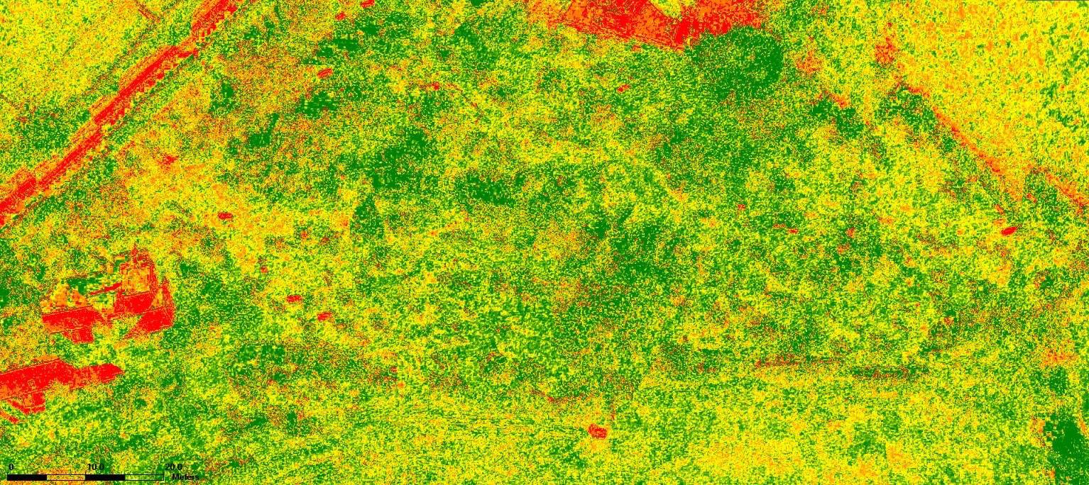
Mike explains that multispectral imaging examines both visible and invisible light frequencies; from the full set of colours to near-infrared and red-edge. The sensor records images in colour (RGB), nearinfrared (NIR) and red-edge (NDRE) and these can be observed in different layers, each of which shows a detail that isn't visible in the others. The RGB are like Hi-Res photos which can show details not observable at ground level, the NIR images can highlight changes in the reflectivity of soil compaction and NDRE examines the overall health of vegetation...but how does this help identify a grave?
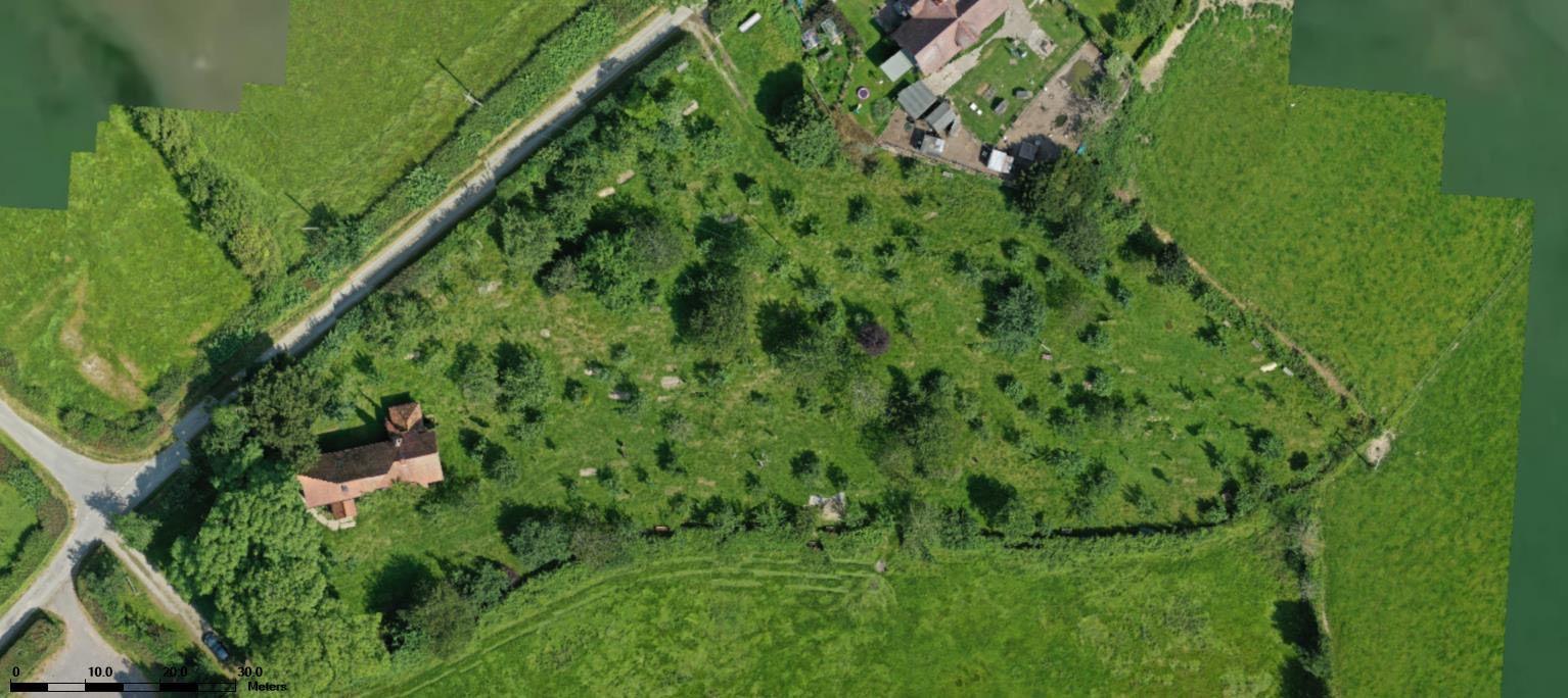
Anyone involved with forensics, cadaver search teams or law enforcement have a degree of training on fieldcraft; identifiable markers that could distinguish a burial site from any other piece of land.
These markers could be identification based, with trees, rocks or other local markers near to a grave, or the use of triangulation between landmarks. Other elements of fieldcraft include practical elements, such as convenience of carrying a body from a vehicle to the grave, so access routes are a must. Concealment from view whilst digging a grave can often rule out some locations; it takes considerable time to dig a grave and privacy is essential to not being caught. This is also true with types of soil, with softer soil easier to dig, so graves tend not to be in heavy clay soil. When a body is buried, either the grave is totally refilled, leaving a lump in the ground, (as the body is taking up space in the grave) which is easy to distinguish, or only some of the soil is returned in order to will leave a spoil heap nearby; a spoil heap is the leftover earth left from the grave.
Changes in the topography of the area, spoil heaps and identifiable grave cuts in the soil are the key factors that are looked at using the RGB imaging.
The NIR imaging examines a number of unseen elements, all of which could be crucial to understanding burial locations. Firstly the sensor can detect changes in the direction of vegetation, for instance, if someone has walked through a field of grass, the direction the grass is pushed is different from the grass around it and these trails could be indication of the route tend not to be in heavy clay soil. When a body is buried, either the grave is totally refilled, leaving a lump in the ground, (as the body is taking up space in the grave) which is easy to distinguish, or only some of the soil is returned in order to will leave a spoil heap nearby; a spoil heap is the leftover earth left from the grave.
Changes in the topography of the area, spoil heaps and identifiable grave cuts in the soil are the key factors that are looked at using the RGB imaging.
The NIR imaging examines a number of unseen elements, all of which could be crucial to understanding burial locations. Firstly the sensor can detect changes in the direction of vegetation, for instance, if someone has walked through a field of grass, the direction the grass is pushed is different from the grass around it and these trails could be indication of the route the murderer took to the grave; these areas could provide valuable forensic evidence as well as building part of chain of events. More importantly, the NIR sensor detects a change in reflectance between compacted soil and turned over soil. As a grave is dug, the compacted soil breaks apart and allows air and moisture between the finer particles and, even when squeezed back down, these air gaps and moisture saturation remain, showing a distinctive pattern when observed next to soil that has been compacted for hundreds or thousands of years.


It is widely accepted that the vegetation above a grave is fundamentally altered, due to the decomposition of the body below, due to the chemical changes in the soil, primarily the nature of the microbial activity within it.
When a body starts to decompose, one of the chemicals it releases in ammonia, which ordinarily would be converted by bacteria into nitrites and then into nitrates and is a valuable source of food used by plants for photosynthesis, however, around a decomposing body the ammonia stays as it is or is halted in the conversion process to nitrites, both of which are toxic to plant life; this results in the plants not being able to grow and start to die off.
The damages area around a grave site is referred to as a cadaver decomposition island (CDI) and this is where the red-edge (NDRE) sensor comes into play. Originally designed as an agricultural sensor, the NDRE unit examines the amount of available chlorophyll in plant leaves and identifies areas of poor health as a series of red pixels and healthy vegetation as green pixels. Combining the 3 layers of images allows a unique perspective into the locations of anomalous areas that could be potential grave sites.
Mike's fascinating look into the unseen side of clandestine graves has been made possible with the support of several scientists, professors, institutions, search teams, law enforcement professionals, and drone pilots, as well as agricultural specialists; this meeting of disciplines has enabled Mike to undertake hundreds of experimental flights using both "human analogue" graves and natural (human) burial grounds to collect the data he is now sharing with the world. These experiments have also allowed Mike to be involved with several search & rescue operations and his dedication has now been recognised as he takes his place alongside experts in their field at Kenyon International Emergency Services, adding to their 115 years of crisis management and disaster incident response. Mike explained "I feel that I am at the age where I need to do something to give back to this world and Kenyon allows me to use my skill set to do that very thing. With recent events like the earthquake in Syria and Turkey or the conflict in Ukraine, the world needs people who can make a difference, to make a difference".
In 2022, a landmark team of disaster victim identification (DVI) experts were assembled to address the ongoing situation in the Ukraine; specifically, how international standards of practice could assist and, possibly, improve the capability and procedures of the underpressure, Ministry of Justice of Ukraine. The experts ranged from pathologists to lawyers, odontologists to family liaison, crime scene imaging to CBRN (Chemical, Biological, Radioactive, Nuclear) and antiterrorist police officers; all with decades of experience in DVI. Mike was asked to become a member of the team at ETAFDVI; the European Training Center of Active Forensic Sciences & Disaster Victim Identification, journeying to Hungary, to join the Hungarian Federal Police and ETAFDVI, to host and train delegates of the Kyiv Scientific Research Institute of Forensic Sciences in the use of drones in the detection of single and mass clandestine graves.
Speaking about this momentous event, Mike said "It was a hugely humbling experience. To be around people with such vast experience was inspiring, but the stories we heard from our Ukrainian counterparts were horrifying; made even worse, when, two days after they returned to Kyiv, the first of the drone strikes hit the city. We were sent live videos they recorded of the explosions outside their facility, shared messages of support and concern as they waited for evacuation during the bombardment...suddenly, everything we heard about became so very real. Fortunately, they were safe and, as a testament to their resolve, went back to work the following day, recovering the bodies of their fallen countrymen. Its those type of people who we aim to emulate in our own actions".
The interview concluded with the question of what brought Mike into this field of research, he elaborated "having visited a number of UAV trade shows and reading numerous research journals, it became very obvious that the types of detection methods were unavailable to most police forces, due to the huge costs involved. I wanted to develop a low cost, portable system that was using currently available technology and that could be retro-fitted to existing drone fleets; that way, a high quality multispectral sensor could be purchased for the same cost as a dive team or helicopter would cost them for the day. The more accessible this technology is, the cheaper it becomes and the wider the usage. Drones are used often in search & rescue operations but not so much in forensic searches and that is something I would like to see change in the future".
Mike's research can be found at: https:// library.college.police.uk/docs/theses/ PARSONS-Drones-Detection-HumanRemains-2020.pdf

Mike Parsons
Aerial Necrosearch Specialist. PhD Researcher. Kenyon International Team Member. ETAF DVI Trainer
Email: mikeparsons1974@gmail. com


