
18 minute read
RESEARCH NOTICES
Maritime Endangered Archaeology Project
Andreou, G.M., H.O. Huigens, R. Ortiz-Vazquez, J. Nikolaus, K. Westley, C. Safadi, C. Breen and L. Blue
Advertisement
Maritime cultural heritage is exceptionally vulnerable to natural processes such as shifting coastal geomorphology, sea-level rise, tropical cyclones and erosion, many of which are associated with climate change as explored in scholarly literature. This is also due to the nature and location of coastal, nearshore and underwater features, as well as the higher population density of coastal locales and associated demographic pressures, which often result in increasing building, industrial and touristic development. These are issues known both to governments and the academic community with a growing corpus of published coastal assessment methodologies implementing shoreline change models, terrestrial and UAV surveys, remote sensing, and community-engagement approaches. The remarkable range of tested methodologies on coastal monitoring in archaeology combined with the long history of archaeological research in the Middle East and North Africa (MENA) offer an excellent opportunity for the assessment and monitoring of the rich maritime cultural heritage of this region.
Research into the maritime cultural heritage of the MENA is largely undertaken by non-local professionals, including important attempts to build capacity (Blue and Breen 2019; Demesticha et al. 2019). At a local level oftentimes the lack of infrastructure, expertise and often financial resources can inhibit long-term monitoring and management of maritime cultural heritage. Above all, the development of effective management and mitigation strategies for the loss of maritime cultural heritage is frequently hindered by a lack of baseline data relating to cultural heritage (e.g. site location) and potential threats (natural and anthropogenic).
The Maritime Endangered Archaeology (MarEA) Project aims to address some of these challenges and highlight the maritime cultural heritage of this region and its historic importance. MarEA is a 5-year collaborative project (20192024) based at the University of Southampton and Ulster University and funded by the Arcadia fund, a charitable fund of Lisbet Rausing and Peter Baldwin. MarEA aims to enhance the understanding of maritime cultural heritage and its environmental setting by documenting site locations and monitoring any disturbances and threats visible to maritime archaeological sites in the MENA region. One of the key aims of the project is to liaise with local government agencies and in-country partners to collaborate in achieving these goals and assist in the development of training programmes and tools designed to engage with local communities and enhance the efficiency of existing heritage management strategies. The initial focus of the project is to rapidly create a digital inventory of sites and features, with emphasis on associated information on disturbances and threats using existing literature and remote sensing analysis (aerial photographs, satellite imagery), supplemented, where possible, with geophysical data and field observations (Figure 1). These observations are stored in an online database (database. eamena.org) and form the basis of subsequent monitoring of sites, and in-depth research on specific phenomena that are impacting these sites such as flooding, coastal erosion and anthropogenic alterations (Figures 2-3).
Figure 1: Ongoing documentation of pre-1960s shipwrecks in Oman (based on existing databases such as www.wrecksite.eu).
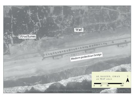

Figure 2: Flooding after Depression ARB1 cyclone event in Salalah, Oman. Close-up to Al Baleed (Imagery acquired and used with permission from Maxar Technologies; image analysis on ArcGIS Pro)
With its long and extensively documented maritime history, the Arabian Peninsula lends itself exceptionally well to the study of maritime archaeological landscapes, offering an extensive range of case studies from prehistoric cave sites and shell middens to historic fishing villages and ports. The region’s geological, environmental, political and socioeconomic diversity allows a more widely encompassing consideration of threats and disturbances to maritime cultural heritage, offering important examples for effective monitoring and management strategies.
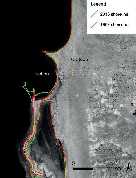
Figure 3: Shoreline development around the historic port town of
Mokha, southwest Yemen between 1967 and 2016 (Corona imagery basemap acquired and used with permission of USGS; image analysis on ArcGIS Pro).
Updates of MarEA’s activities are posted in the format of tweets (@MarEA_project) or blogs on the project’s website (marea.soton.ac.uk) with a wide array of subjects including maritime archaeology and climate change, the heritage dimension of marine protected areas and the ethics of media representation of cultural heritage.
References
Andreou, G., L. Blue, C. Breen, C. El Safadi, H. Huigens, J. Nikolaus, R. Ortiz-Vasquez and K. Westley 2020. Maritime endangered archaeology of the Middle East and North Africa: The MarEA project. Antiquity 94(378), E36. doi:10.15184/aqy.2020.196
Blue, L. and C. Breen 2019. Maritime Archaeology and Capacity Development in the Global South. Journal of Maritime Archaeology 14. Springer US: 321–32. https://doi. org/10.1007/s11457-019-09244-x. https://doi.org/10.1007/ s11457-019-09244-x. Demesticha, S., L. Semaan and Z. Morsy 2019. Capacity Building in Maritime Archaeology: The Case of the Eastern Mediterranean (Cyprus, Lebanon and Egypt). Journal of Maritime Archaeology 14. Springer US: 369–89. https:// doi.org/10.1007/s11457-019-09243-y. https://doi.org/10.1007/ s11457-019-09243-y.
Remote Survey of Desert Kites in Northern Arabia
Michael Fradley and Francesca Simi
The past decade has seen a renewed interest in the form, function and spread of desert kites across the Middle East and beyond, in part led by the increasing availability of high-resolution satellite imagery on which the low, extensive form of the structures is easily observed (Kennedy et al. 2015). New remote-sensing survey by the Arcadia-funded Endangered Archaeology in the Middle East and North Africa (EAMENA) project at the University of Oxford has furthered this research through the documentation of a new distribution of desert kites across northern Saudi Arabia and in to southern Iraq.
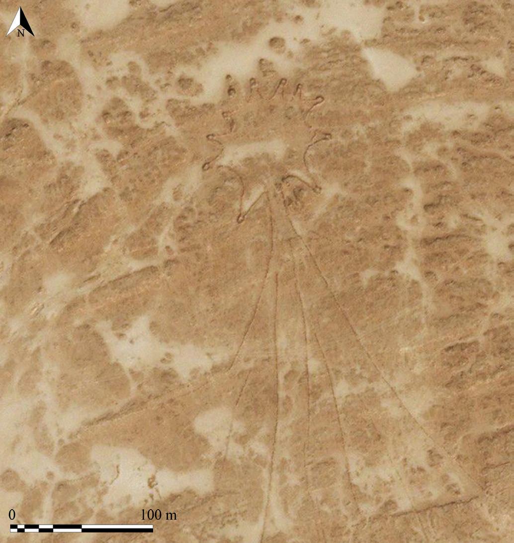
Figure 1. An example of a kite documented by EAMENA in southern Iraq (Source: Bing Maps)
Over 300 new desert kite sites have been documented, potentially forming a continuation of the known distributions running through Syria and eastern Jordan, through to the Jowf region of Saudi Arabia. This new data represents a significant increase in terms of the known number of desert kites in Saudi Arabia, and an important advance in our geographical understanding of their spread across the region. In addition to documenting desert kites, this survey has recorded a range of other site types, largely consisting of different cairn forms such as pendant and bullseye forms. In addition, a small number of ‘meandering walls’ were recorded, comparable to those identified in Jordan
and elsewhere in Saudi Arabia, and suggested as a possible precursor to the developed desert kite form (Betts and Burke 2015, 81-2).
The results of this new survey will be published shortly. The full dataset for the survey, including the kites and other recorded site types, will be uploaded on to the EAMENA online database once it is re-launched, and external users will be able to apply for access. The project can be followed via social media or its website (www.eamena.arch.ox.ac.uk).
References
Betts, A. and Burke, D. 2015. ‘Desert Kites in Jordan: a new appraisal’. Arabian Archaeology and Epigraphy 26, 74-94.
Kennedy, D. L., Banks, R. and Dalton, M. 2015. ‘Kites in Saudi Arabia’. Arabian Archaeology and Epigraphy 26
Analysis of Early Islamic Burials in Syria point to direct link with Arabia
Andrew Petersen
For more than a decade a multi-national, interdisciplinary team have been studying the ritual Neotlithic (PPNB) funerary area at Tell Qarassa in southern Syria (Santana et al 2015). Tell Qarassa lies at the southern edge of the Leja, a forbidding basalt covered region located between the ancient cities of Damascus and Bosra. Although the village of Qarassa appears to be a relatively recent settlement there is evidence of Roman, Byzantine and Medieval occupation both in the immediate area and in the wider region.
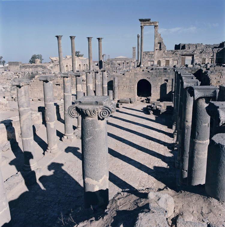
Roman street in the southern Syrian city of Bosra. The city had had frequent trade with the Hijaz both in pre-Islamic and early Islamic times.
Archaeological survey work in the region indicates that there was a substantial population during the Roman, Byzantine and early Islamic periods with a significant break at the end of the Umayyad period (circa 750). Large scale occupation of the area appears to have resumed in the eleventh and twelfth centuries and continued into the early Ottoman period (Guérin 2008, 268-272). Sixteenth century Ottoman tax registers indicate that the Leja region was occupied both by villages and nomadic groups including Turcoman and various Arab Bedouin tribes (Guérin 2002). The first Druze populations arrived in the region in the seventeenth century fleeing persecution in Mount Lebanon.
In addition to the ninth century BC cemetery the site of Tell Qarassa North also includes Neolithic houses and is located on the shores of a dried up lake. During excavation of the cemetery two graves were found in the upper levels which were thought to be of a later date. Both of the graves were set within stone lined rectangular pits aligned East-West with the head turned south in conformity with traditional Muslim burial practice. The fact that these were the only later burials at the site suggest that they were related in some way. Carbon dating of the remains revealed that both individuals died within ten years of each other sometime in the early 700’s and as such were of considerable importance in understanding early Islamic society.
Given the potential significance of the graves a range of bio-archaeological analyses were subsequently carried out on the burials providing a fascinating insight into the identity of the individuals. At present there are no examples of DNA studies from the region which relate to this period and worldwide the only DNA analysis which relates to early Islamic burials is the study of two individuals from the south of France (Gleize et al 2016).
The full results of this research will be published in the journal Nature Communications (Srigyan et al. in press): however in the meantime a brief summary of the results will provide some idea of their potential significance. One of the most interesting findings of the Genomic analysis is that the individuals showed closer affinities to Arabia and in particular Bedouin groups rather than to Levantine groups as one might expect to find in Syria. The fact that the individuals were also Muslim provides a tantalising snapshot of population movement in the first century of Islam.
This finding can be linked to what we know of this region during the Late Antique and early Islamic times. There had been direct connections between southern Syria and the Hijaz for centuries (Sartre 1985, 129-131). In pre-Islamic times these connections are in the form of direct trade between Mecca and the Hauran. We know for example that one of Muhammad’s ancestors Hāshīm organized a bi-annual caravan carrying grain from the Hauran to Mecca and that as a young man Muhammad travelled to Bosra as a merchant (Ṭabarī cited in Sartre 1985, 230 n.261 and 262). The direct connection between Mecca and the Hauran was continued in Islamic times with the annual pilgrimage or Hajj. In addition to the passage of pilgrims the Hauran continued to send supplies of food and camels to Mecca.
Gleize, Y.,F Mendisco, M-H.Permonge, C. Hubert, A.Groppi, B Houix, M-F.Deguilloux and J-Y Breuil (2016) Early Medieval Muslim Graves in France: First Archaeological, Anthropological and Palaeogenic Evidence. https://journals. plos.org/plosone/article?id=10.1371/journal.pone.0148583
Guérin, A. (2002) Interprétation d’une register fiscal Ottoman: les territoires de la Syrie Méridonale en 1005/159797 in Journal of Near Eastern Studies Vol. 66/1 pp. 229-278.
Guérin, A. (2008) Le village de Mseikeh et le Léjà à la période islamique (viiᵉ-xvᵉ siècle). Archéologie du peuplement et historire des territoires pp 261-273 in P. Clauss -Balty ed. Hauran III L’Habitat dans les Campaigns de Syrie du Sud aux Époque classique et médiévale CNRS Beirut.
Santana, J, J. Velasco, A.Balbo, E. Iriarte, L.Zapata, L. Teira, C. Nicolle, F. Braemer, J.J. Ibáňez (2015) "Interpreting a ritual funerary area at the Early Neolithic site of Tell Qarassa North (South Syria, late 9th millennium BC)" Journal of Anthropological Archaeology 37 (2015) 112-127. Sartre, M (1985) Bostra. Des origins à l’Islam BAH 117, Paris.
Megha Srigyan, Héctor Bolívar, Irene Ureña, Jonathan Santana, Andrew Petersen, Eneko Iriarte, Emrah Kırdök, Nora Bergfeldt, Alice Mora, Mattias Jakobsson, Colin Smith, Juan José Ibañez, Anders Götherström, Torsten Günther, Cristina Valdiosera “Bioarchaeological evidence of one of the earliest Islamic burials in the Levant” Nature Communications 2020 (in press).
Gulf Institute of Gemology: An archaeometry analytical facility available “on– site”
Maya Musa GIG – Gulf Institute of Gemology, Research Department - Bait Al Reem, 3rd Floor, Thaqafah St, Al Khuwair 133, Muscat - Sultanate of Oman
Although it might seem unlikely that a gemological institute can be of assistance to the world of archaeology, this article explains why such an institute is a valuable ally for archaeological research.
The GIG Institute
The Gulf Institute of Gemology (GIG) is an Omani paragovernment institution recently (2019) founded with the purpose to assist in the regulation, transparency and ethical business conduct in the gemstone and jewelry industry in Oman and the GCC region.
To achieve this, GIG has acquired a strong international character, as proven by its human resources -a heterogeneous group of experienced professionals- as well as with the application of the highest standards for gem material analysis. In fact, GIG is part of an elite of ten International Gemological Institutes (CIBJO recognized), in part, because of its high-tech analytical equipment. Indeed, one of the main tasks performed by a Gemological Institute is to identify Gem materials. To do that in a more modern acceptation of “scientific gemology”, the application of advanced analytical techniques (i.e. spectroscopies or chemistry analyses) are required, but analyzing the sample without any preparation is mandatory. This is the reason why GIG is equipped with three different spectroscopy lines (UV-Vis/NIR, FTIR and micro-ATR, micro-Raman spectroscopy), two chemical analyses (ED-XRF and LA-ICP-MS) and several imaging systems (i.e. optical microscopes, UV fluorescence imaging, optical gauge, etc.). All of those non-destructive techniques can be applied on the same sample in a complementary way, thanks to their specific accessories.
Similarly cultural heritage, archaeological samples and objets d’art require the same analytical attention and they cannot be analyzed by destructive techniques. For this reason, the High-Tech instruments available at GIG institute are suitable also for the archaeometry studies (Fig.1). In the next section some application examples are reported.
GIGArt Division and Archaeological Collaborations
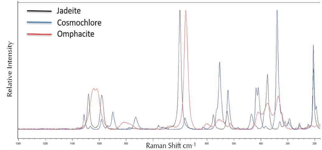
Starting from a vocation for studying antique jewellery, in the recent years the GIG team has been involved in several international collaborations for cultural heritage. An example is “The Chiaravalle Cross” where a multidisciplinary approach has been applied for a complete characterization of this medieval masterpiece [Di Martino, et al. 2019]. Consequently, a division of the GIG Research department has been dedicated to cultural heritage, archaeological and objets d’art research projects, the GIGArt division. Starting from the end of 2019, GIGArt division has been involved in several international collaborations –e.g. the French Archaeological Mission "Archéologie des rivages de la mer d'Arabie", having the chance to analyse several archaeological samples found during the 2019 excavation campaign. A deep micro-Raman characterization, including Raman mapping, combined with ED-XRF analyses on
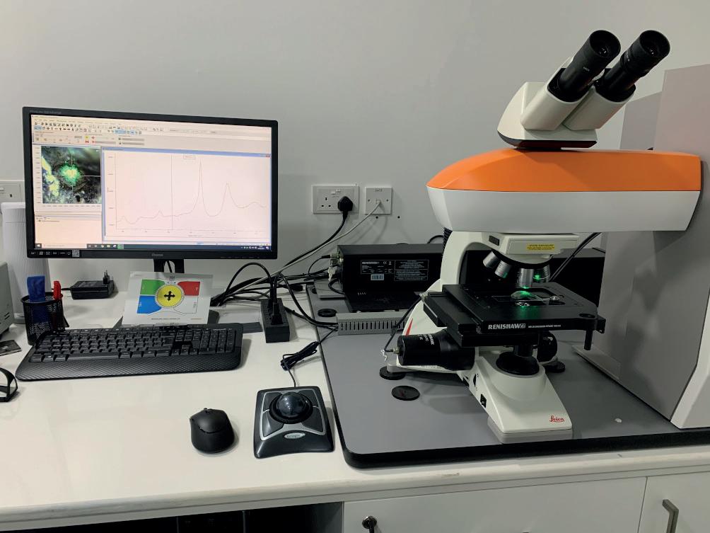
Neolithic axes have been carried out [Al-Kindi, et al., 2021 submitted]. The micro-Raman spectroscopy is a very useful non-destructive technique capable of characterizing the samples. Actually, this technique finds its application in many sectors, due to its versatility (i.e. cultural heritage, minerals, pigments, organic chemistry, etc). In a typical Raman experiment, monochromatic radiation (the laser source) is used to excite the sample. The Raman scattered photons present differences in the energy corresponding to the specific vibrational modes of the sample and characterizing the material like a fingerprint (Fig. 2) [Schubnel, 1992]. The latest generation of micro-Raman spectrophotometers are also able to create maps, on the
basis of the sample’s Raman scattering. This application's results are particularly suitable i.e. for polyphasic samples, where the composition, the mineral’s distribution or the mineral’s crystallinity are uneven. Indeed, the Spectrophotometer is coupled in a confocal way with an optical microscope and the analyses are spatially solved.
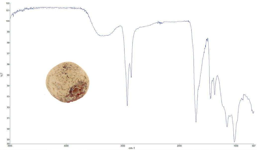
GIGArt has also been involved in collaboration with the Peretti Museum Foundation, in a project aimed to increase the knowledge of amber, especially for geographic origin determination, where an innovative methodology based on the application of the micro-ATR technique coupled with UV Fluorescence Imaging has been carried out [Musa, et al., 2021]. This methodology's results are particularly suitable for the archaeological amber beads and their identification (Fig. 3).
Conclusion
GIG Research Department is also available for high-tech courses and, as soon as the restrictions due to the COVID-19 will be lifted, it will be possible for Masters' degree or PhD. students to perform their analyses at the GIG facility. In the meantime, we are organizing virtual tours as well as ondemand courses.
In conclusion, as “an archaeometry analytical facility available on-site” GIGArt division’s goal is to assist the archaeological teams working in the Arabian Peninsula with high-tech analytical support.
References
Al-Kindi M., Charpentier V., Maiorano M.P., Musa M., Pavan A., Heward A., Vosges J., Marchand G., Pickford M., (2021 Submitted), Evidence of Neolithic long-distance exchange in Southern Arabia: The road of the Jade axes, Journal of Archaeological Science: Reports.
Di Martino D., et al., (2019) The Chiaravalle Cross: Results of a Multidisciplinary Study, Heritage 2, 2555–2572; doi:10.3390/heritage2030157.
Musa M., Kaye T.G., Bieri W., Peretti A., 2021, Burmese Amber Compared Using Micro-Attenuated Total Reflection Infrared Spectroscopy and Ultraviolet Imaging, Applied Spectroscopy, doi: 10.1177/0003702820986880.
Schubnel H.J., 1992. Une méthode modern d’identification et d’authentification des gemmes. La Microsonde Raman en Gemmologie, 5-10.
WORK IN PROGRESS
A historical perspective on Arabia’s marine life: call for collaborators
Dr. Alec Moore
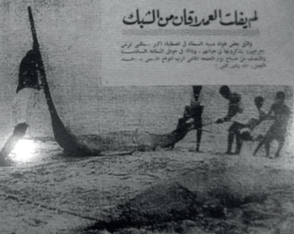
On arrival at Aden in the 1870s, the boat on which the German naturalist Ernst Haeckel was travelling was “… surrounded by Arab boats, whose…passengers clambered on board to offer [for sale] … huge saws from the sawfish…”. Sawfish – huge, shark-like rays, are now essentially extinct in the Arabian region. It is only by piecing together evidence like Haeckel’s diary note that allows us to understand how incomplete our modern perception of what is ‘normal’, based on a few decades of recent scientific data, can be of a degraded ecosystem. This ‘shifting baseline syndrome’
is one of the key areas that the growing field of marine historical ecology hopes to address. By documenting the former status of marine animal populations, we are better informed to set ambitious targets for their restoration that will benefit biodiversity, fisheries, and those who depend on them.
I am a marine biologist, and much of my previous research has been on sharks and rays in the Arabian region. While much of this has been more ‘conventional’ marine biology, I am increasingly interested in multidisciplinary approaches using a variety of less conventional data sources that mention marine animals or their products – such as historical documents (e.g. navigational pilots, charts, ship’s logs, expedition narratives/journals, old photos), trade archives (e.g. for shark’s fins, ambergris), art, archaeology and interviews with fishing, pearl diving and maritime communities. My aim is to use these to document the former distribution, abundance and diversity of marine animals in Arabian seas (such as sharks, rays, whales and dolphins, turtles, fish). However, the vast expanse of potentially useful material is bewildering, especially to someone lacking formal research experience in these disciplines.
Are any IASA members working in these – or related – disciplines aware of potentially useful sources on marine animals? If so, I would be really grateful to hear from you to discuss potential collaborations. Many thanks in advance,
Dr. Alec Moore a.moore@bangor.ac.uk School of Ocean Sciences, Bangor University IUCN Shark Specialist Group (Indian Ocean Region)
The Gulf as a Forgotten WWII Operational Theatre
Dr. Saif Albedwawi
For quite some years I have been searching for information on the role of the Arab Gulf States during WWII. It seems that it has been forgotten by researchers as a theatre of war and is not even to be found in the literature of military historians, with the exception of a few short papers written by local residents1 .
There are five main contributors in this arena: first, the massive role of the RAF that kept all the German, Italian, and Japanese movements under surveillance. Second, the US Air force deployment to Sharjah that lasted for almost two years not recognized by any writer2. Third, the role of the Iraqi Levies in protecting the only active airfield on the Trucial coast at Al Mahattah, Sharjah. Of these Iraqi soldiers, originally recruited to be part of the Habbaniya air field in Iraq during WWII, one squadron was sent to Sharjah almost every six months to guard the RAF aircraft whilst they were performing their missions in supporting Allied warfare. A fourth source of information is related to the Number 26, 2021 air crashes in the Emirates of both US and British aircrafts during the war. These crashes were not the result of combat but rather of mechanical failure. Ali Iqbal a local researcher, has located some 19 aircraft that crashed at various sites within the present day UAE.
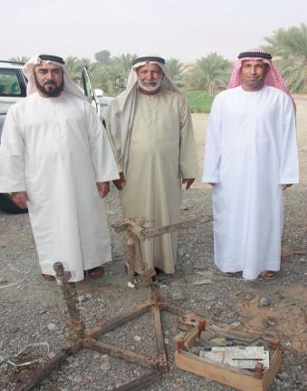
The fifth source is rather rare and almost unbelievable. There are two known submarines that were sunk in the Gulf area. These boats are still sitting on the bottom of the sea without any work on them. For example, the German submarine sunk by RAF in 1943, found and located close to Fujairah’s coast3 .
In summary, there is a need to carry out in-depth research to recognise this “Forgotten Theatre of War” in the Arabian Desert of today’s UAE and to produce a work that records the activities of the various forces that were stationed in the Trucial Coast during WWII, and their role in defeating the German-Italian Axis.
References
1. Ali Iqbal, Peter Hellyer and Laurence Garey, The UAE in World War Two: A forgotten fatal air crash in Sharjah. Tribulus Vol. 25 – 2017, P., 25-32. 2. Nicholas Stanley-Price,(2012), Imperial Outpost in the Gulf. 3. IOR/L/PS/12/1986, Coll 5/34 ‘Meteorological Stations in Persian Gulf: Bahrain & Sharjah’, 1934-1948.
Dr. Saif Albedwawi Historian from UAE. Saif4933@hotmail.com


