BLUE SENSE RESIDENCE
ARCHITECTURE PROJECT thynguyenkt@gmail.com – ( 84 ) 909069472

PROFESSIONAL COMPETITION | TEAMWORK | 2022
PTW VIETNAM LTD. | HCMC | VIETNAM
Swan Island - Central Business District Concept Design CompetitionFirst Prize
Project Location | Swan Island, Dong Nai Province, Vietnam Project Manager | Ly Vinh Nhi (M.Arch-Senior Architect)
Other Members | Dinh Thanh Tung, Hoang Tung Cuong, Trinh Tien Vinh My Duty | Architecture Concept Design, Sustainability Strategies Study, Concept Presentation Submission & Visualization Controlling Quality.
This Masterplan Concept Design is a competition offering the proposal for the Central Business District (CBD) of Swan Island. The Masterplan Concept Design needs to follow the previous 1/500 susmission to the authority with given functional zones and parameters. Given the densed setting of the CBD, the design strategy is to explore and take advantages of all built spaces to creat a breathing community for future residences.
The project, which functions as Central Business District of Swan Island, is located between the existing international airport and the future Long Thanh International Airport. Taking avantages of the future highway connection between these two transport hub and the , the site functions as high-end residences and luxurious business zones in order to build up the priority economic value of the whole island.

The site can be accessed through Long Thanh Dau Giay highway and Road 51 Interchage. Marina River Hub will be constructed in the future, facilitating the water connection with Ho Chi Minh city on the opposite side of the river.


Located in separated island, the inner system is already constructed with developed residences zones in the southern part. However, the currently only accessed through the northeast bridge.


separated roads already fully residences southern site is accessed northeast

Diverse ecosystem with maintaining existing greenery as much as possible is the key factor of the development of the site.

Given the 1/2000 Master Plan submission to authority, the Plot is clearly divided into 2 separated zones along the internal road: highrise mixed-use and low-rise apartments.


The rearrangement of buillding clocks is to take advantages of prevailing wind and develope further solar protection for South West side.
The pattern uses the difference of function to refine the plot segmentation. Blocks are divided to allow pedestrian access and enhance micro-climate
Inspired by the site’s inherent riverscape, the project aims to generate a sustainable and tropical urban neighborhood by evoking an underlying Blue Sense theme with the intergration of water bodies into the site.

Existing Cross-Island Road Site Boundary Road
Existing Island Internal Road
Previous Proposed Internal Road


The site is divided into conventional functions by internal roads. A vehicle-centered neighborhood could be seen.
Pedestrian Route Protected Intersection
The project aims to enhance the environment to support sustainability by maintain and enhance the current high coverage of blue and green spaces.
The isolation of the site urges the planners to create a selfsufficient community: housing, commercial, agriculture and energy independence, etc. at its highest level
New proposal aims to foster the pedestrian-based community, where vehicular roads around the site, whereas internal crossing designed with slow-traffic elements. The that become pedestrian avenue is the the site.
Located in an isolated island that is surrounded by river, creating a resilent urban areas is one of the most pivotal principles, focusing on adaption to climate change and allowing the whole area to function well in the long run.

Implementing a mixed-use and fully-functional urban area, we reaarange the master plan in order to provide the new community accessibility to their essential needs within 15 minutes of walking, cycling & public transportation.
Waterfront corridor Ecological Buffer corridor Interconnected Open corridor
The key corridor space structure is the pedestrian-based waterway to connect functional areas. Green belts corridors zone for CBD area . Pendicular open enhance connections with surrounded


Local Vehicle Movements
Transient Vehicle Movements
Main access is through the North-West Bridge. Boundary Roads reinforce the split of the site from other neighborhood areas of the island. Internal Roads split in inner parts of the site and leave no characteristics of the neighborhood.
The roads prevent connection and communities being formed in the site neighborhood.
500m
Activated neighborhood edges
Neighborhood center: Island Scale Neighborhood center: CBD Scale Neighborhood center: Block Scale
Sense of community is formed by various scale of neighborhood gathering: island-scale plaza for islandy community, CBD-scale open plaza for people on site, block-scale served residents inside blocks


conventional plots with vehicle-centered pedestrian-based are located crossing roads are The spinal road key feature of the centered connect various act as buffer open corridors surrounded greenery.
Neighborhood gathering Housing Apartment Mixed use Education Commercial
Centered area of the site is potentially the most accessible, therefore, neighborhood gathering spots are established along this centerline, allowing a walkable community where residents could easily and safely access to sufficient amenities.
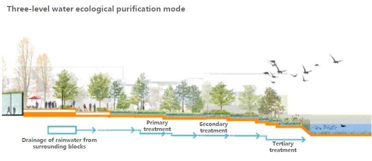
The planning ensures that the water body maintains good water landscape through elastic water surface design, and scattered green spaces can be used as flooded areas to ensure that the site is not flooded. The central canal of the site and the multi-stage slope along the coastline are constructed together in order to meet the flood control, and the surrounding surface is purified by the wetland system.

The key corridor space structure is the centered pedestrian-based waterway to connect various functional areas. Green belts corridors act as buffer zone for CBD area . Pendicular open corridors enhance connections with surrounded greenery.


The safely walkable environment is formed by 1. All vehicular access are located in the boundary 2. The spine internal road is transformed into 3. The existing pendicular roads are designed both accessibility to the site and the safe envronment
1
Waterfront corridor
Ecological Buffer corridor Interconnected Open corridor
Pedestrian-based avenue, which is located at the heart of the site, aims to bring residents from both sides of the canal together to enjoy waterfront amenities.


4 1 2 3 4
2 3
Lotus Island scale: Central Plaza
CBD scale: Innovative Park Building scale: Courtyard, Green roof Unit scale: Balcony

Vehicle Route
Slow-Traffic Route Bike Route Pedestrian Route Drop-off location
by the following strategies: boundary roads.
pedestrian-based network along the canal. with slow-traffic features in order to ensure envronment for cyclists & pedestrians

Concept revolves around creating a dynamic and varied experience along the length of the canal - the spine of Ecology, Cultures & Community of the whole site. To achieve this, various unique activities could be proposed along the main pedestrian walkway.
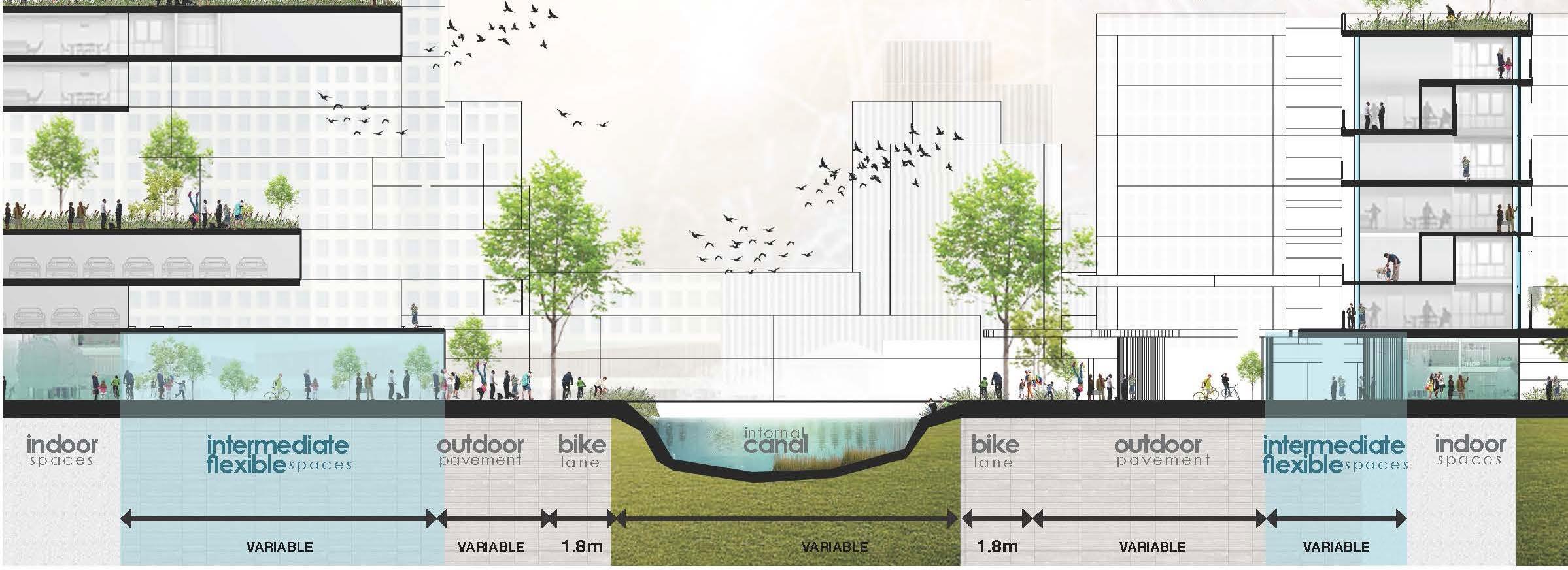


Intermediate spaces act as a shading transition from air-conditioned indoor areas into outdoor spaces. They are the key tranformation of the urban area, creating the sense of place and offering further opportunities to create the diversity of activities along the Luminous Avenue (commercial, F&B, culture events,etc.)

Master plan phases are divided based on demand. Self-sufficient module, which ensures its own facilities regardless of other adjacent areas, includes high-rise mixed-use, low-rise residences and basic infrastructure.


Form & function
sky communal garden
Basic Infrastructure Self-sufficient module Based on demand/ developer’s project stages
maximized retail frontage
private rooftop
podium rooftop sky walkway pedestrian-friendly central area intermediate spaces

car-free private courtyard open& accessible ground floor


