
2 minute read
The Project Site


The site and its context As mentioned above, the class focused on a mauka to makai transect through Waikīkī, reaching from the northern bank of the Ala Wai Canal to the ocean—including the federal lands surrounding Fort DeRussy. Pre-development, the studio project area (also see page 3 above) was part of a drainage basin characterized by springs, streams, such as Pi’inaio Stream, and swamp land. Pre-Western contact, the ‘Ewa end of Waikīkī was part of the Hawaiian community of Kalia. It was characterized by numerous traditional fishponds (loko i’a) surrounded and residences owned by native Hawaiian royalty. In 1908 the U.S. military acquired, occupied, drained, and filled a large parcel of land for the subsequent construction of Fort DeRussy.
The project area included the mauka and makai banks of the Ala Wai, part of the canal itself, the residential and commercial areas to the north and south of Kalakaua Ave, Waikīkī Gateway Park, and a variety of facilities located on a 72-acre plat of federal land (2066 Kalia Rd), including the Asia-Pacific Center for Security Studies, the US Post Office, Ainahau Triangle, the Kalia Road parking area, the various Hale Koa Hotel amenities (military personnel and dependents only), the U.S. Army Museum of Hawai’i, as well as Fort DeRussy park, boardwalk and beach, and the near-shore portion of the Pacific Ocean.
Advertisement
THREE FEET OF SEA LEVEL RISE
Our Site Within Waikīkī SIX FEET OF SEA LEVEL RISE
Our Site Within Waikīkī
Emily Sobolewski Knight & Eric Teeples | ARCH 743 | Prof. Judith Stilgenbauer
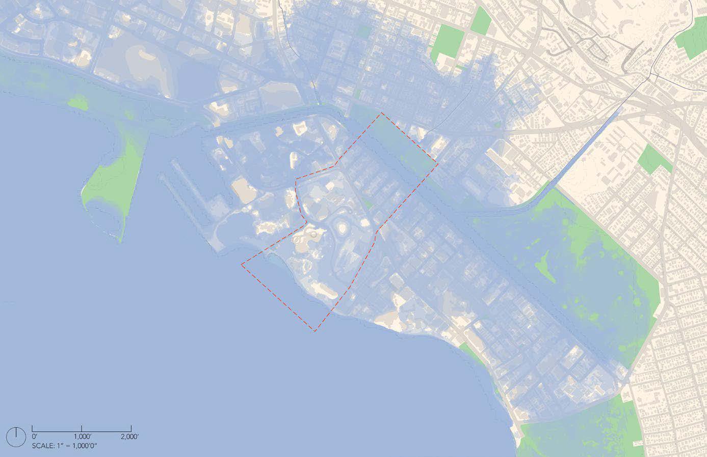
3-ft SLR impact; image: Emily Sobolewski Knight and Eric Teeples
Emily Sobolewski Knight & Eric Teeples | ARCH 743 | Prof. Judith Stilgenbauer
6-ft SLR impact; image: Emily Sobolewski Knight and Eric Teeples
General project goals and land use parameters explored by students: Climate-crisis and SLR anticipation and preparedness Enhancing coastal resilience through adaptive, urban ecological design and nature-based solutions Adaptation strategies for existing urban infrastructure (transportation, sewer, water, energy facilities, etc.) Large-scale coastal green infrastructure/ living shorelines and open space networks Water-sensitive low-impact development Ecosystem performance, water quality, habitat, biodiversity Adaptive multi-purpose infrastructural systems Carbon neutrality, clean energy Mixed use development, including affordable housing Waterfront amenities, public access Recreational and water-based activities Pedestrian, transit, water, and bicycle connectivity; walkability Alternate, clean forms of transportation connecting to rail and TOD Urban placemaking, livability Productive landscape elements; urban agriculture; resource management Modern interpretations of traditional Hawaiian bio-cultural land-water practices and applications Cultural sensitivity and history of place; decolonization Green jobs and eco tourism Beaches of the future Public works initiatives Environmental and social equity and justice; jobs; social services Etc.
Flooding and inundation vulnerabilities of coastal area that students were asked to consider: Saltwater inundation (SLR, increased wave overtopping, hurricane/ storm surges, tsunami) Salt intrusion/potable water contamination (freshwater changes/water table rise, effect on low-lying agriculture and aquatic ecosystems) Erosion of shorelines and beaches Ground water inundation resulting from SLR Habitat shifts (coral reefs, wetlands, etc.) Ecological impacts Stormwater management (storm sewers), increased flooding in low-lying areas, drainage problems, streets becoming impassable, etc. Release and leaching of pollutants at contaminated sites, landfills, etc. Sewers, cesspools, storm sewers, energy facilities, transportation systems, and other critical urban infrastructure Existing building stock and critical building systems Public access to shoreline and non-automobile connectivity Vulnerable populations, public health impacts Etc.


