
4 minute read
Day Hikes


A Walk in the Park
BRYCE CANYON Queen’s Garden
Advertisement
1.8 miles Descending from the famed Sunrise Point, wide open vistas and scenic views of Bryce Canyon’s hoodoos define the Queen’s Garden trail. Out and back, this short hike is the easiest available in the national park. Descending below the canyon rim, hikers can choose to loop back up to the rim or combine it with Navajo Loop for a longer, more strenuous hiking experience.
LAKE POWELLGRAND STAIRCASE Devils Garden
1 mile There’s no better introduction to hiking the arid, trail-less slickrock landscape typical of Grand Staircase-Escalante National Monument than Devils Garden, a 1-square-mile collection of sandstone hoodoos, arches, and toadstool rocks formed over the last 166 million years by erosion and weathering. None of the trails here are marked, and that’s part of what makes hiking here so interesting. Bonus points for packing a picnic—a picnic area here has tables, fire pits, and elevated grills.
ACADIA Cadillac Mountain, North Ridge
4 miles round-trip At 1,529 feet in elevation, Cadillac Mountain is the highest point in the park and on the U.S.’s eastern seaboard. You can drive to the top (where there’s a half-mile paved pathway loop), but the effort of walking the 2 miles and 1,150 vertical feet up the mountain’s North Ridge Trail is worth it for the views along the way—Eagle Lake, Dorr Mountain, and Bar Harbor.
MOAB Delicate Arch

3 miles round-trip Delicate Arch is a bucket-list sight. How close you get will depend on your group’s hiking chops. Walk the entire length of the Delicate Arch Trail (mostly uphill on the way to the arch) and you’ll be rewarded with a close-up view of the arch, and pass a wall of ancient Ute Indian petroglyphs. the warnings when high water closes the trail.
ZION The Narrows
3-4+ miles round-trip Zion is known for its magnificent slot canyons, and on the Narrows Trail, you’ll walk through one in the ankle- or knee-deep water of the gently flowing Virgin River. That’s right: The trail is a river. You can hike as far in as you have the stamina for—most people cover 3 or 4 miles of the trail. Just heed
Grotto Falls, Great Smoky Mountains The Narrows, Zion
YELLOWSTONE Upper Geyser Basin Trail

5 miles round-trip Start at the Old Faithful Inn, in front of the Old Faithful Geyser, and you are situated within 2 square miles of a quarter of all the geysers in the world. From Old Faithful, take the paved path toward Castle Geyser (0.2 miles). From there, take the boardwalk across the Firehole River to the Sawmill Geyser. To complete the hike, follow the north trail to Grand Geyser, Beauty Pool, Oblong Geyser, and Giant Geyser before the trail joins again with the Upper Geyser Trail.
MOUNT RUSHMORE Presidential Trail
0.6 miles round-trip The paved trail is hilly (you’ll have to climb some stairs), but it’s short enough that even the youngest hikers should
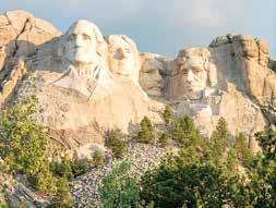
Presidential Trail, Mount Rushmore Grinnell Lake, Glacier

have no trouble traversing the 0.6-mile loop. The prize? A clear view of the sculpted faces of Presidents Washington, Jefferson, Roosevelt, and Lincoln carved into Mount Rushmore.
GLACIER Grinnell Lake
3 miles round-trip Catch the ferries across Swiftcurrent and Josephine Lakes with Glacier Park Boat Company. Once you hop off, you’ll hike around 1.3 miles up to the turquoise waters of Grinnell Lake, filled with meltwater from the Grinnell Glacier above. Bonus: It’s all downhill back to the ferry. Boat reservations made prior to visiting recommended.
GREAT SMOKY MOUNTAINS Grotto Falls
2.5 miles round-trip On a hot day, park at the Trillium Gap Trail parking lot and hike to Grotto Falls. The trek comes with a unique payoff: the chance to cool down behind the cascade of Grotto Falls, the only waterfall in the park you can walk behind. Once you cool down—from the misting water or from plunging into the swimming hole created by the falls—you can either hike back to the trailhead or continue on up the trail that eventually hits the summit of 6,593-foothigh Mount Le Conte.

GRAND CANYON South Kaibab Trailhead
3 miles round-trip From the South Rim, the Grand Canyon looks vast, but until you get down into it, you can’t grasp the scale of it. The Kaibab Trail will deliver. The steep but well-trod path drops 1,110 feet in 1.5 miles to your turnaround point at Cedar Ridge, where you’ll find toilet facilities, space to spread out for a snack, and an awestruck understanding of the geological forces that formed the canyon. You will not find any water, though. Give yourself twice as much time to make the climb back up. If you’re lucky, you’ll pass the park’s mule train heading up or down the trail, delivering supplies and people to Phantom Ranch at the bottom of the canyon.
Grand Canyon


