
26 minute read
Mobility Framework


Existing Pedestrian Circulation
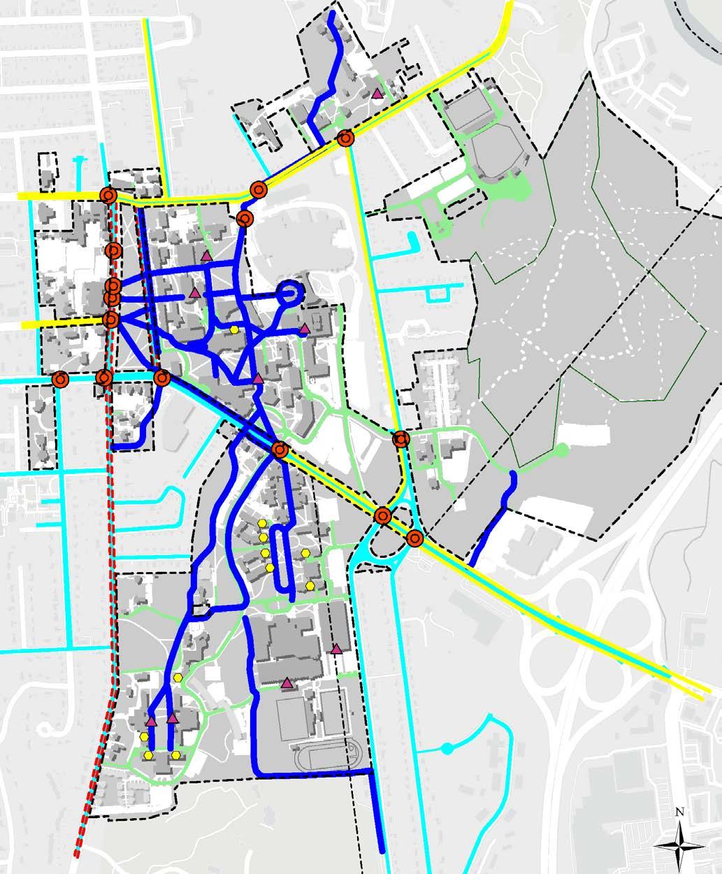
Primary Circulation Path Informal Gathering Area Secondary Circulation Path Tertiary Circulation Path UVM Property Boundary
Advertisement
Map data © OpenStreetMap contributors, Microsoft, Esri Community Maps contributors, Map layer by Esri
The University of Vermont has a well-established network of existing paths that make non-motorized transportation a viable way to move around campus. The campus must function as a pedestrian environment throughout the year including the winter months, which can be challenging. Walking and biking are the primary means of travel around campus, although the efficient shuttle system is a popular alternative, especially from the farther reaches of campus.
There have been many improvements and additional plans since the 2006 CMP. This plan reflected a desire to improve the campus landscape through better pedestrian amenities and landscaping improvements. In particular, in 2011, the Landscape Advisory Subcommittee compiled recommendations for open space and walkway improvements, which have since been mostly implemented. In 2017, UVM adopted the UVMoves Active Transportation Plan which was developed with the goal to increase rates of non-motorized mobility through improving walking and biking conditions in the campus environment. In 2020, UVM also completed the Transportation Master Plan which included key recommendations to develop parking program goals and priorities, improve transit connections, and expand active transportation and TDM opportunities. Since the adoption of these plans, several pathways have been improved to better reflect the desire lines and travel patterns. For example, several “cow paths”, (eroded paths in the lawn areas), have been paved since these reveal legitimate travel connections. Also, some of the redundant pathways have been removed to reduce impervious cover. Currently, there are still a number of issues associated with the campus pedestrian and bicycle circulation network. Surfacing, signage, and pathway widths are inconsistent. Conflicts continue to exist among walkers, skateboarders, bicyclists, and vehicles. As the density of campus development has increased and the emphasis on pedestrian and bicycle circulation continues, it is imperative for the institution to improve the safety, flow, and function of its pedestrian and bicycle facilities and circulation system. . Existing Pedestrian Circulation Map Primary circulation paths encompass circulation between residential areas of campus and the academic core. They are analogous to commuter roads in the city. Primary circulation routes are likely to be longer than other pathways taken on campus, cross major roads, and have points of conflict with vehicular traffic. They need to accommodate peak crowds throughout the day, in addition to cyclists and other mobility modes. An example of a primary circulation path is the Green Mountain Pathway (existing Redstone Walkway and Green Mountain Walkway).
Secondary pedestrian paths encompass circulation within a given district. They are shorter journeys between major buildings. Secondary paths often accommodate large numbers of students, particularly at peak moments during the school day. These are trips between classes and to dining areas. Their use tends to taper off at the end of the school day.
Tertiary pedestrian routes include paths at the periphery of campus. These routes are generally serving members traveling to campus or cover trips between smaller facilities. Tertiary paths are most likely to be city pavements or even informal paths cutting across lawns.
Informal gathering points are key to the success of a good campus. They generally occur at intersection points on well-traveled pathways and at the entrances to major campus buildings, at spots with good exposure to sunlight and shelter in inclement weather. They are the setting for the random encounters that make for a rich, spontaneous, and vibrant university life.
Existing Bicycle Circulation
Indoor Bike Storage Outdoor Covered Bike Parking Conflict Area Striped Bike Lane Shared-Use Path Conflicts Along Road Public Roads Limited Access Campus Road UVM Property Boundary
Existing Bicycle Circulation Map Bicycling continues to be a popular form of both recreational and functional travel to, from, and within the University of Vermont campus. UVM is currently a Goldlevel Bicycle Friendly University, designated by the League of American Bicyclists, in recognition of the institution’s achievements in promoting and enabling safe, accessible bicycling on campus. The current state of bicycle travel in and around the campus has several areas that need attention, including: 1. Lack of definition between walking and bicycling routes 2. Inadequate widths of circulation routes to support multimodal travel 3. No identification of bicycle routes 4. Confusion as to where the university system and routes connect with designated city and regional routes 5. Conflicts between bicyclists and pedestrians at certain locations within the campus 6. Inadequate road capacities for bicycling and inconsistent lane delineation along streets such as Main
Street
Greater Burlington has benefited from the growth of bicycling and bicycle facilities through the efforts of groups such as Local Motion, The Burlington Walk/Bike Council, the Chittenden County Regional Planning Commission (CCRPC), and the local municipalities. The city of Burlington has been a designated Bike Friendly Community since 2005. Chittenden Area Transportation Management Association (CATMA) has also been extensively involved in developing bicycling initiatives working cooperatively with each of these groups. Recently, strides have been made to critical bike routes around campus, including the Pearl Street/Colchester Avenue corridor which now has bike lanes heading east and west from campus.
In April 2018, UVM partnered with three municipalities, UVMMC, CATMA, CCRPC, and Champlain College to bring the bikeshare system to campus. This bikeshare was upgraded in 2020, swapping out the 125 pedal bikes for 200 e-assist bikes. There are eight stations on campus and UVM students and employees are eligible for discounted memberships. Also, the student-run UVM Bike Co-Op provides free bike fixes and low-cost rentals to the UVM community. While it is unrealistic to expect that bicyclists will and can limit themselves to designated routes for bicycle travel, it is clear that there are a number of primary patterns within the campus; these typically mirror the north-south and east-west travel patterns on campus. At the campus perimeter, there is limited connectivity with regional routes and bicycling to destinations such as South Campus District properties, downtown Burlington, Winooski, and Williston Road/ Dorset Street businesses.

Campus and Surrounding Mobility Conflict Areas
UVM Mobility Areas Needing Improvement Municipal Mobility Areas Needing Improvement GMP - Primary Bike Route GMP - Primary Walking Route UVM Property Boundary
South Prospect Street/ Colchester Avenue University Place/ Colchester Avenue
Main Street/ South Prospect Street
Main Street/ University Place
Green Mountain Pathway (GMP) Green Mountain Pathway (GMP)
East Avenue/ Colchester Avenue
East Avenue Corridor
Aiken Stairs
Main Street/ University
Sidewalk Along Main Street
Jughandle
Spear Street Corridor
Connection to South Burlington Rec Path Exit 14 Interchange
Pedestrian/Bicycle Bridge Over I-89
There are several major points of conflict where pedestrian and bicycle paths cross heavily trafficked roads. Students traveling to and from the Main Campus cross fast-moving traffic on Colchester Avenue, Main Street, East Avenue, Spear Street, and South Prospect Street daily. Long waits for lights obstruct the flow between campus districts and the sense of a cohesive pedestrian circulation system. Many of these conflict areas are owned and controlled by the municipalities (Burlington and South Burlington).
Main Street/Williston Road Main Street, a major arterial and route to downtown Burlington that bisects the campus, provides the primary east-west corridor for all modes of traffic. The pedestrian underpass at the intersection of a the Green Mountain Pathway (former Redstone Walkway) and Main Street creates a grade separation between pedestrians and traffic and connects to the Dudley H. Davis Center. However, the majority of students cross Main Street at the intersection of University Heights Road, which has heavy pedestrian volume during class changes, without adequate infrastructure to address the periodic high volume of pedestrians, bicycles, and vehicles.
The corner of Main Street and South Prospect Street, an expansive and busy 3-legged intersection, is also a highvolume area for vehicles, pedestrians, and bicycles. There are not adequate bicycle and pedestrian facilities at this intersection.
The jug handle intersection of Main Street and Spear Street/East Avenue is a high traffic volume area and can be challenging to navigate for pedestrians, bicyclists, and vehicles. In 2015, the university installed a UVM Gateway sign to define the southeasterly entrance to campus in a difficult area. Also, the Main Street/Williston Road corridor leading to and from campus includes several transitions of bicycle facilities, going from off-road, on-road, and off-road again, within a short road span. This introduces conflicts and is not very accommodating or safe for pedestrians and bicycles. The city of South Burlington recently installed a sidewalk near East Terrace and has plans to construct a pedestrian and bicycle bridge south of Exit 14 of the I-89/ Williston Road intersection to provide a safe and protected way to travel between South Burlington and Burlington. Spear Street Spear Street is a critical corridor for the campus and surrounding community and lacks basic infrastructure such as sidewalks and bike lanes, creating a barrier for those unable or choose not to drive to campus.
East Avenue East Avenue is also a critical north-south corridor for the campus community and lacks a northbound bike lane.
Colchester Avenue The difficulty of crossing heavy traffic on Colchester Avenue to get from the Central District to the Trinity District has a strong impact on the overall perception of isolation felt by Trinity residents. The lack of connectivity and accessibility has recently been improved with the installation of a midblock crossing at Fletcher Place and the replacement and widening of the existing side path on the south side of Colchester Avenue between South Prospect Street and East Avenue. Also, UVM and UVMMC completed the Green Mountain Pathway segment from the Central Campus Residence Hall to Colchester Avenue. There are also plans for the city of Burlington to improve safety, parking, and bicycling along Colchester Avenue to include separated bike lanes and the realignment of the East Avenue intersection and the Prospect Street/Pearl Street intersection. Pedestrian and bicycle circulation must become a priority in the ongoing efforts to improve safety and connectivity to the Trinity District.
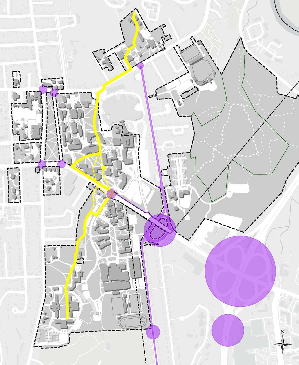
Mobility Priority Areas
University Place (Under Construction)
Covered Bike Parking (In-Design)
Enhance Connection Across Main Street

Parking Improvements at Interfaith Center/ Catholic Center
Green Mountain Pathway (GMP) Improvements Covered Bike Parking
Green Mountain Pathway (GMP) Improvements
Green Mountain Pathway (GMP) Improvements
Covered Bike Parking (In-Design) Mobility Priority Areas UVM Property Boundary
The overall goal for the future bicycle and pedestrian network on the campus is to provide the safest, most logical, and engaging circulation system for pedestrians and bicyclists, and to sustain a seamless connection with all modes of travel including the CATS shuttle system, as well as external vehicular access and parking.
University Place The University of Vermont, in partnership with the city of Burlington, is in the process of constructing street improvements for the University Place public street and associated right of way. The project will improve safety on the street for pedestrians, bicyclists, and other active transportation users. Physical changes to the street will include limiting vehicle traffic to one-way northbound, eliminating most on-street parking, adding bike lanes and additional/improved sidewalks, creating space for food trucks on the south side of the street near Main Street, and improving and focusing on crosswalks in one central area. This was one of the priority landscape design projects in the 2006 CMP and is a signature project recommendation in the UVMoves Active Transportation Plan.
Enhance Connection across Main Street The crossing at Main Street and University Heights is the heaviest and most critical crossing location for nonmotorized users on campus. At this intersection, Main Street is also U.S. Route 2, a state route, increasing the complexity to coordinate improvements. There is not enough space in the existing crosswalk or time allotted to accommodate the high volume of users during class changes. As a result, many users navigate this intersection improperly. Infrastructure improvements and retiming of lights can better designate spaces for different modes and therefore allow more efficient crossings of the intersection. With the availability of new federal and state funding, the university can coordinate with the city of Burlington to explore more significant improvements. The current tunnel provides access to the Davis Center which is not along the route of many destinations. The pathways leading to the Davis Center tunnel could be improved to increase non-motorized use through enhancements such as covered walkways, lighting, seating, signage, or visual interest such as murals, etc.
Green Mountain Pathway Improvements The Green Mountain Pathway (GMP) is a campus-wide proposed north-south active mobility corridor intended to improve connectivity and contribute to the cohesiveness of the outdoor experience. This can be accomplished with the merging of the Green Mountain Walkway and Redstone Walkway and continuing the pathway into the Trinity District. Its design expression should promote continuity while amplifying the unique characteristics of each area of campus through which it passes. Because the route of the GMP spans the full elevation change within the campus, it can be seen as a microcosm of the larger Vermont landscape, which is characterized by its dramatic topography. The GMP should promote all forms of nonmotorized mobility and have signage and policies that promote safety and a sense of shared experience. While the best configuration for the various use zones of the pathway should be determined through additional study, it is recommended to include a separation where higherspeed modes such as bikes and electric scooters may come in conflict with slower-speed modes such as pedestrians and those needing assistance. The UVM campus already consists of a palette of elements including pavement types, planting, and signage that could be drawn from for the GMP. Other elements such as lighting and site furnishings might depart from the existing palette and contribute instead to the uniqueness of this linear landscape route. A robust stormwater management strategy that is expressed through bioswales or other best practices is also recommended.
Covered Bike Parking Covered bike parking helps to protect bicycles from the elements, such as snow and rain, a benefit that is especially important given Burlington’s harsh winters. Covered bike parking is recommended across campus and shelters should serve both popular origins and destinations. Key areas of focus are those not adequately served by indoor bike rooms, including Trinity District, Central District (Davis Center), Redstone District, and the Athletic District (Harris/ Millis). Two covered bike parking structures near the Davis Center and Harris/Millis are currently in planning/ construction. These areas would enable many bicyclists to park their bicycles in a visible, covered location, and then walk to their final destination. Providing visible, secure, and convenient covered parking not only makes bicycling a year-round option, but properly sited structures can also promote bicyclists to park and walk in more heavily congested areas where conflict with pedestrians may be higher.
The Pedestrian Campus
Pedestrian and Bicycle Circulation
The implementation of a truly pedestrian campus is a key vision and continues to be one of the primary goals of the University of Vermont Campus Plan. A range of interrelated initiatives are proposed to accomplish this goal. These include multi-modal pathway networks to reinforce the north-south circulation spine of the campus, design enhancements and amenities for pedestrian and bicycle travel, further improvements to the popular and successful Campus Area Transportation System (CATS) shuttle service, and an emphasis on serving the majority of the parking needs in peripheral lots located at the perimeter of the campus. However, as parking lots are redeveloped for building sites, this affects Transportation and Parking Services’ revenue. Assessment of these revenue implications should be considered for any redevelopment. UVM Main Campus serves approximately 16,000 people and currently manages approximately 5,000 parking spaces. This presents an opportunity for sustainable transportation initiatives, including transportation demand management. The Campus Plan also identifies priority landscape projects to significantly improve the open space network by building and/or connecting components of the outdoor experience across campus (refer to the Open Space and Landscape Framework).
The university has developed a hierarchical system of pathway designations for the future delineation of vehicular, bicycle, and pedestrian routes on campus. This approach will guide the implementation of new pathways as well as the reconfiguration and rehabilitation of existing pathways. The proposed pathway network includes:
Multi-Use Paths – 15’ to 24’ in width to accommodate shuttle, service, and emergency vehicles such as the Green Mountain Pathway and the pathways through the Andrew Harris Commons. In some cases, multi-use pathways will be shared roads assigned to accommodate limited-service vehicle and shuttle traffic. Surfacing will be primarily asphalt, but textured or otherwise defined lanes for bicycle and pedestrian travel on one or both sides of the vehicular travel way should be considered as a design option.
Primary Pathways – 8’ to 15’ in width and should support bikes and pedestrians with limited-service vehicular use for access to utilities. At utility access points extra coverage should be built in to prevent vehicle damage to lawn areas. These paths would comprise part of the bicycle network so logically they should connect with each other across campus.
Secondary Walkways – 5’ to 8’ and primarily for pedestrian use only. These are typically city and limiteduse sidewalks. These are almost always of concrete construction and where they follow or relate to the municipal networks, the surfacing should remain concrete. Note that all pedestrian and bicycle facilities will be designed in accordance with American Association of State and Highway Officials (AASHTO) standards and builtin conformance with Vermont Agency of Transportation (VTrans) construction specifications.
Entry Areas and Plazas – These will also continue to be an integral part of the pedestrian campus when located as part of a building entry or to provide outdoor gathering spaces. These areas will be constructed of similar materials already being used around campus, including concrete pavers, native stone, or patterned concrete. Brick should be used as an accent element rather than as the primary surfacing material. Accessible entryways and seating will be another important consideration in the design of these plazas and building arrival areas.
Interior Circulation - Where possible, new construction will consider circulation routes and their connectivity. The goal is to create alternative options to other buildings within the interior of buildings for pedestrian use during the winter months and inclement weather.
Several additional considerations and initiatives will further support the goal of creating a complete pedestrian campus. For example, future routing of pathways will serve land bank areas as they are developed. “Trunk routes,” the primary circulation network through the campus will be consistently signed and surfaced to better accommodate skateboarders, bicyclists, and pedestrians together on
one route, such as the Green Mountain Pathway. Future or refined bicycle routes will need to be reviewed by the appropriate municipalities and organizations. Overall accessibility for pedestrians will also be an important consideration in pathway location and design.
Transition and conflict areas must be dealt with consistently via the use of signage, appropriate infrastructure, and policies. Bike lanes and routes might also employ color treatments as an approach to better “signing” the routes. However, maintenance must be considered with regard to the surface coloring. Service and shuttle roads can also accommodate bicyclists, and shuttle stop pullovers may be necessary to avoid conflicts inflow, particularly with increased shuttle headways over time. Bicycle routes from peripheral lots need to be reinforced and added as peripheral lot expansion occurs. Bike racks should be appropriately located at all buildings and meet Association of Pedestrian and Bicycle Professionals (APBP) standards. Current bike rack locations and conditions should be continuously assessed and improved over time. Bicycle amenities such as route maps, improved signage, covered storage and a commuter bike facility with lockers/tools/ showers are to be considered as improvements in the future.
Accessibility Planning
The university continues to improve accessibility in facilities, including buildings and the physical landscape. Accessibility and Flexibility are one of the overall guiding principles for the Campus Plan. As part of this principle, it is important to apply the seven principles of universal design to guide decision making: • Equitable Use - The design is useful and marketable to people with diverse abilities. • Flexibility in Use - The design accommodates a wide range of individual preferences and abilities. • Simple and Intuitive Use - Use of the design is easy to understand, regardless of the user’s experience, knowledge, language skills, or current concentration level. • Perceptible Information - The design communicates necessary information effectively to the user, regardless of ambient conditions or the user’s sensory abilities. • Tolerance for Error - The design minimizes hazards and the adverse consequences of accidental or unintended actions. • Low Physical Effort - The design can be used efficiently and comfortably and with a minimum of fatigue. • Consider Size and Space for Approach and Use -
Appropriate size and space is provided for approach, reach, manipulation, and use regardless of user’s body size, posture, or mobility. The university is conducting a self-assessment in an effort to identify barriers in the physical environment. As part of this work, UVM will create a transition plan to guide future planning and implementation of accessibility improvements.
It is the policy of UVM to comply with all U.S. laws and regulations relating to the provision of equal access to those with disabilities, and to provide reasonable and effective accommodations that enable qualified UVM students, employees and, where applicable, members of the public with disabilities, equal access to its programs, services, activities, and information. Specifically, UVM is required to adhere to Section 504 of the Rehabilitation Act of 1973, 29 U.S.C. 794 (Section 504), the Americans with Disabilities Act of 1990, 42 U.S.C. 12131 (the ADA), as amended by the Americans with Disabilities Act Amendments Act of 2008, (the ADAAA), and applicable Vermont law.
Vehicular and Campus Shuttle Circulation
contributors, Map layer by Esri Map data © OpenStreetMap contributors, Microsoft, Esri Community Maps Ü

Bus Stops CATS Shuttle - Redstone Express CATS Shuttle - On Campus Parking - Faculty/Staff Parking - Faculty/Staff/Student Parking - Paid Visitor Parking - UVM Medical Center UVM Property Boundary
Ü
Map data © OpenStreetMap contributors, Microsoft, Esri Community Maps contributors, Map layer by Esri
Vehicular circulation is a necessary component of the campus circulation network at the University of Vermont. Vehicular circulation on roads and pathways is necessary to allow access for service vehicles, visitor and handicapped parking, and a minimum of proximate or short-term parking for faculty and staff. Currently, on campus, there are several shared-use roadways or pathways that serve the multiple modes of transportation that the university community relies on to get to and around the campus.
The existing network of paths and roads within the campus lacks consistent widths and is not well delineated or designed to readily accommodate the flow of shuttle and truck traffic. These routes are shared by all campus travelers including vendors, bicyclists, and pedestrians. In some locations and instances, there are safety concerns and conflicts between users. There is a range of conditions of the roads and pathways across campus. There are many locations where service and vendor vehicles have used access paths that are too narrow or lack sufficient subbase to support these vehicles with the consequent impact to the surface and adjacent landscaped or lawn areas. Additionally, it may not be necessary for vendor and service vehicles to access some of the multi-use pathways, such as the area around Andrew Harris Commons, and efforts have been made to minimize this including signage and staff education.
The Campus Area Transportation System (CATS) will continue to be the backbone of the university’s transportation system. UVM has ten shuttle buses on three static routes as well as the CATSRide on-demand service to transport users to non-shuttle route areas of campus and off-campus to UVM owned properties within the metro area. This type of transportation is critical for a campus that spans well over 1.5 miles from the Redstone District to the Trinity District. The CATS buses are integral to a pedestrian campus. The shuttle bus system allows commuters, faculty, and staff to park at the campus perimeter in the peripheral lots and travel safely, comfortably, and promptly to their university destinations. Furthermore, in a move towards a more sustainable environmental operation, on-campus buses will be hybrid, electric, or powered by Renewable Natural Gas (RNG) whenever possible, and route locations will serve the expanded pathway system and peripheral lots, as well as efficiently link up with the local and regional bus routes. The CATS network will continue to be based on ridership needs and thus have a certain level of adaptability in terms of routing and stops designed to serve the campus districts and the land bank areas as they are developed. Thus, shuttle routes need to be flexible and adaptable over time and will continue to serve the key campus destinations. Co-location of internal shuttle routes and service roads currently exists and will continue where possible. These routes will continue to serve bicyclists as well, reinforcing the internal shared roadway network. This network should be continually redeveloped over time so that roadways reflect consistent widths, surfacing, signing, and are designed with alignments that are more fluid to better accommodate traffic flows amongst a diversity of users. Another need with regard to enhancing the shuttle system will be to improve and/or upgrade shuttle stops to provide better protection from inclement weather. Students currently wait in or under the cover of adjacent buildings until the shuttle arrives. This practice should continue where appropriate. In locations where this opportunity does not exist, the university should build shuttle stops with coverage and amenities so that students can wait safely and comfortably.
Funding for shuttle system improvements could be obtained through new development projects which result in the need for changes to the system. It is envisioned that the CATS shuttle system will connect effectively with the evolving regional transit system as well, to promote commuting via public transit. If new peripheral parking lots or satellite parking lots are added, then the CATS shuttle system or other shuttles may be used to serve users as needed.
The shuttle bus system will continue to be integrated with the other university circulation systems, i.e., pedestrian, bicycle, and vehicular to ensure that movement around the university campus is a seamless experience.
The CATS shuttle service has continued to evolve as a reliable and important piece of the comprehensive oncampus transportation network. It provides linkages with downtown, the airport, Amtrak, and the waterfront via buses operated by Green Mountain Transit (GMT). GMT serves as an important partner connecting commuters with their home and/or an expansive network of park and ride lots. As of fall 2022, GMT fares are free for all users and UVM makes financial contributions to assist in this initiative.
Vehicular and Campus Shuttle Circulation
Transportation Demand Management
Parking at the university is managed by UVM Transportation and Parking Services. The provision of parking on campus is a dynamic process, shifting as needed to accommodate new demands, new buildings, and relocation of existing parking spaces. Parking policies are also adapted to reflect an increased focus on TDM, increased telework options, accessibility requirements, as well as land use changes resulting from new construction. As parking lots are redeveloped for building sites, this affects Transportation and Parking Services’ revenue. Assessment of these revenue implications should be considered for any redevelopment.
Electric Vehicle Infrastructure UVM installed its first electric vehicle charging station in 2016 and has rapidly expanded to 18 charging ports by 2020. These ports are primarily Level 2 (240V), except two stations in Gutterson Garage that are Level 1 (120V). UVM has seen an increase in demand for these stations and intends to create a charging station master plan to help focus on intentional expansion and serving the needs of all campus community members, including supporting residential students and assisting the university fleet transition to electric. This also contributes to UVM’s overall reduction of its carbon footprint. There is also potential for on-demand compact EV vehicles that would be intended to provide transportation for short trips in the immediate area.
Transportation Demand Management, known more simply as TDM, consists of specialized policies, targeted programs, innovative mobility services, and products that encourage people to use sustainable modes of transportation, rather than driving alone, or make fewer trips by car. TDM programs attempt to counterbalance the incentives to drive that are so prevalent in subsidies of parking and roads.
Burlington Ordinance Article 8 Section 8.1.16 defines the goals of TDM to reduce parking demand, reduce car ownership, reduce vehicle miles traveled (VMT) and congestion, and increase transit use and non-motorized travel. (Excerpted from CATMA’s JIPMP Update, 2022.)
At UVM, TDM goals include reducing the need for parking on campus, the need to build additional parking facilities, and the university’s carbon footprint. The university, in collaboration with CATMA, has an extensive array of TDM options that are detailed in the most recent Joint Institutional Parking Management Plan (JIPMP) and its yearly updates. These options include: • Free public transit service • CATMA Bike/Walk Rewards Program • Bikeshare System Access/Member Discounts • Carpool/Vanpool Services • CarShare Vermont System Access/Campus Discounts • Guaranteed Ride Home • Education, Outreach, and Awareness In addition, UVM provides: • On-campus CATS shuttle buses • A shuttle tracking system for on-campus buses: TransLoc
Real-Time Shuttle App • On-campus academic year bike rentals and bike fixes through the UVM Bikes! Co-op • A learning module that explains all the university TDM options, mandatory for anyone who requests a parking pass on campus • UVM Telework Policy that allows staff members to submit requests for a telework schedule • Parking policies that give various incentives to use cars as little as possible: o Employee permits within the core campus are more expensive than peripheral areas. o The cost of employee permits is progressive, i.e., higher paid employees pay more for their parking permit (up to a certain point). o Zoned lots create a “park once” campus. o All on-campus students are discouraged from bringing cars to campus. o First-year students are prohibited from bringing cars to campus unless the student can prove a special need. o Resident student permits are priced higher than commuter student permits. o Only students living farther than a half-mile of CATS shuttle stops are eligible for a commuter
permit. o Off-campus students within a half-mile of CATS shuttle stops may be eligible for an evening commuter permit. o Preferential parking for carpools. o As of Fall 2021, UVM added daily parking permits, reducing incentives to daily driving. All of the measures listed above contribute to a lower rate of UVM affiliates using their cars to drive to and from, and on-campus on a daily basis. The university will continue to develop further measures to encourage active and sustainable modes of transportation and discourage single occupancy of vehicles.
CATS shuttle bus


Electrical vehicle (EV) charging stations UVM Bikes! a student run bicycle co-op repairing bikes


