
8 minute read
Trinity District


Located northeast of the Central District, and north of the main arterial of Colchester Avenue, the Trinity District was added to the UVM campus in 2002 upon the closure of Trinity College and UVM’s subsequent purchase of the campus. Due to the location being somewhat separated from the Central District and a smaller amount of housing and academic uses on the Trinity District, it has tended to be a quieter campus and has the potential for development that may enliven the district and make it a more desirable destination for students, faculty, and staff.
Boundaries The Trinity District is comprised of approximately 21.4 acres and the boundary is defined as the area north of Colchester Avenue, east of Fletcher Place, west of and including the Cottages, and south of the ravine leading down to Riverside Avenue.
Advertisement
Description of Existing The Sisters of Mercy established Trinity College in 1925 as a college for young Catholic women. The early classes met nearby in the Mount St. Mary’s Academy building on Mansfield Avenue. The principal college building, Mann Hall, an imposing brick, flat roof building just west of the Villa, opened in 1940, and its simple Modern style form and flat wall planes foretold the later construction of numerous significant International Style buildings on the campus built between the 1950s and 1970s. In 2002, the University of Vermont purchased the Trinity College campus. The Trinity District contains 18 UVM-owned buildings and has a diverse collection of architecture that includes academic and office buildings and small residence halls. The buildings have a range of materials: Mann Hall built in 1939, has red brick and limestone trim in a late Art Deco Style; McAuley and Mercy Halls were built in 1958 and 1962, and have metal and glass in an International Style; and Delehanty Hall and the “Back Five residence halls (Hunt, Ready, Sichel, Richardson, and McCann), built between 1966 and 1973, have brown brick with slate panels. The roofs are typically flat although the Farrell Building, built in 1985, has a prominent sloping metal roof.
The network of walkways in the Trinity District juxtaposes a formal structure derived from the Trinity grid and the layout of its existing buildings, and a more sinuous series of braided walkways that cuts through the grid on the diagonal
and connects the north edge of Trinity to the rest of the campus. Tree plantings in the Trinity District consist of linear allées blending into alternate side plantings on the braided paths. While the Trinity walkways are narrower than the Green Mountain Pathway, their curvilinear form and similar palette of plant and paving materials will give these paths a unified and coherent appearance. New sidewalks and a bike lane currently exist along Colchester Avenue. A new protected bike lane has been planned by the city of Burlington. This is a main thoroughfare in and out of the city of Burlington and the city of Winooski.
Architectural Features, Styles, and Materials


Goals The majority of new development or redevelopment at UVM in the next ten years will most likely occur in the Trinity District. This allows development to remain within campus boundaries, thereby protecting residential adjacencies and maintaining university presence in Burlington.
There is an opportunity to activate and enliven the Trinity District with the addition of undergraduate and graduate student housing through redevelopment, renovation of existing housing, and/or construction of new housing. There is also an opportunity to foster interdisciplinary work and support research growth through adaptive reuse of buildings such as Farrell Hall, Delehanty Hall, and Mann Hall. Mercy and McAuley Halls also need to be renovated.
Trinity District
Goals In order to meet the housing and development goals, the zoning regulations will need to be updated for this area of campus to add additional development potential within the existing Trinity Campus Institutional Core Campus zoning overlay with increased lot coverage, a standard setback through elimination of the transitional boundary, and the addition of a height overlay on the north side of the campus.
Along Colchester Avenue, the goal is to create a more activated and livelier streetscape for pedestrians and active transportation users. Mixed-use, residential scale buildings could allow for retail opportunities as well as other uses. Other goals include adding seating and programmable space between buildings and within the streetscape. Also, avoid large blank walls and locating structures, parking lots, or other large areas of impervious surface along the streetscape.
The landscape goals are to increase recreational use, remediate stormwater runoff, and provide space for an outdoor amphitheater to take advantage of the existing grading conditions.
Architectural Guidelines Although there are currently no buildings in the Trinity District on the National Register of Historic Places, the potential for any properties in this campus area to be eligible for listing on the state and National Register of Historic Places should be considered. For buildings and features eligible for listing on the Vermont or National Register of Historic Places, all repairs, additions, and modifications should comply with the Secretary of Interior Standards for Rehabilitation in the introduction of this chapter and be coordinated with VDHP.
New buildings in the Trinity District should respect the architectural characteristics of the district in terms of height, mass, scale, and proportions. Exterior walls should be of brick, glass, or stone in a color which is sympathetic to the district. For example, the use of slate (or similar) panels that reference the adjacent buildings would be encouraged. Windows should also fit in with the scale and rhythm of fenestration in adjacent buildings. Depending on the location of new development/ redevelopment, additional materials such as wood or metal may be incorporated to allow for flexibility in the style of architecture. Roofs may be sloped or flat. Landscape Guidelines The Trinity District’s intimate sense of scale, its mixed-use program, and its situation at the edge of a heavily wooded ravine are reflected in a landscape that is more intimate in scale than that of the rest of the campus. The existing fabric of the Trinity District is structured by a grid derived from its neighborhood context that is distinct from those of the rest of the university. The existing character of the landscape has been set by a zoned setback from the road that was put in place around 2001. While this setback may change, future buildings on the Trinity District should maintain some distance from the road to preserve the character of the surrounding neighborhood.
This area of campus is ideal for stormwater management because it is one of the few places on campus with sandy soils that have percolation rates conducive to infiltration and permeation. This part of campus could allow for more Tier 1 and Tier 2 stormwater treatment practices such as bioretention, disconnection, dry swales, infiltration basins, gravel wetlands, etc. to meet state regulations in accordance with the Vermont Stormwater Management Manual.
Low seating/retaining walls in existing topography or terraced areas can create informal seating and gathering as well as provide opportunities to showcase low impact stormwater treatments. Seating can be placed at the edges of walkways, along with trees, to encourage utilization of the outdoor campus landscape. This area is ideal for an outdoor natural amphitheater nestled into the slope(s) as proposed in Chapter 3: Key Ideas. Improvements to the Green Mountain Pathway, a primary north-south mobility corridor, should also continue through the Trinity District, incorporating hardscape, seating, signage, and lighting to be consistent with the linear landscape. See Chapter 3: Key Ideas.
Development Potential There are several land banks in this district. With the potential to increase the lot coverage, add a height overlay, and decrease the setback, there are possibilities for development and/or redevelopment.
There is a residential land bank in the underutilized open space, over the Villa and Boiler House, and over the five residential halls in the northeast corner of this district. This
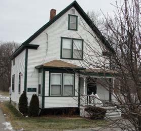
space could be used for additional housing managed by UVM or a third party as well as landscape enhancements. The Villa, originally a c. 1860 farmhouse on the north side of Colchester Avenue, has been moved and modified significantly. It served as a residence for elderly women during the early 1900s and in 1919 the Sisters of Mercy bought the building and soon after moved it back from Colchester Avenue to its existing site, raised the roof, and added the porches and other elements that converted the structure into a dormitory for the college.
There is a general campus use land bank along the Colchester Avenue streetscape. There is potential for mixed-use development and active green space including stormwater management practices, if the setback is decreased. The creation of a lively streetscape can increase perception of safety as well as be an attractive improvement to the neighborhood. There are also academic land banks in between Mann Hall and the Villa and in front of Farrell Hall. The area in front of Farrell Hall may be a possible location for a maker space to help promote community and collaboration.
Considerations Plans and supplemental information related to the planning, design, and approval of a typical building and/or landscape architecture campus project: • 2011 Housing Master Plan • 2018-2019 Housing Master Plan Market Study • UVMoves Active Transportation Plan • Facilities Sustainability Plan • The Villa: Significance and Condition of the building, Liz
Pritchett Associates • VT State Register of Historic Places
Land Banks - Trinity District

Trinity District Boundary Academic Residential
General Campus Use


