Wagga LouisPrecinctWaggaPlanBroadfield PLAN4002/UDES0002 2022 Louis Broadfield Wagga Wagga Urban Design Framework


1.3.a. Regional Context As the largest inland city within New South Wales, Wagga Wagga caters to a large regional population. State significant roadways cross through and encircle the urban areanotably the Sturt Highway and Olympic Highway, forming the primary arteries to Albury, Narrandera, Tumut and Cootamundra. The existing railway line provides twice-daily service to Melbourne and Sydney.
Existing Train Station Primary Structuring Road Secondary School Park Rail Alignment Church Tertiary Education Open Space River Special School Childcare Commercial Area Major Metropolitan Road Primary School Recreation 1:40,000 A3 0 2.5km Wagga Wagga Botanic Gardens, Visit NSW 2022 PLAN4002/UDES0002 2022 Louis Broadfield Wagga Wagga Urban Design Framework City Centre Botanic Gardens Base Hospital Showgrounds TAFE Racecourse Wagga Beach
The urban history of Wagga Wagga can be viewed through its street grid. Older sections near the commercial core are supported by an arrangement of small blocks, responding to the Murrumbidgee River and the Wollundry Lagoon. Much of the urban area - including new developments - are aligned to a north-south offset, achieve optimal solar access. The central business district is located in the north of the urban area, focused upon the axis of Baylis and Fitzmaruice Streets. This precinct is the city’s primary commercial destination, supported by supplementary shopping centres in outer Greenareas.space within the city is plentiful, and leverages topography and waterways to great effect - the Murrumbidgee is home to Wagga Beach, Wilks Park and Wiradjuri Reserve, and Willians Hill provides a dramatic backdrop for the Wagga Wagga Botanic Gardens and Zoo.


PLAN4002/UDES0002 2022 Louis Broadfield Wagga Wagga Urban Design Framework 2.1. Opportunities Mapping Existing Train Station Cross-corridor connection Green grid connection Existing cycleways Rail Alignment Proposed new street Activity corridor Proposed River Proposed active frontages Heritage Open Space Key vista Flooding 1 Provide a new pedestrian and active transport connection over the railway line 2 Opportunity to increase housing density and choice within walking distance to station 3 Opportunity to provide greater choice in green space within the city centre, linking disparate sections of the green grid 4 Retain key view corridors from public domain 5 Interface with heritage items as centrepices of civic space 6 Extend commercial activity to surrounding streets 7 Provide for mid-block connections to increase walkability 8 Create a new, central active transport connection across the rail corridor, increasing north-south permeability 9 Emphasise and extend the existing civic corridor of Baylis Street 1 2 8 2 3 4 5 6 9 6 5 3 7 1:10,000 A3 0 250 500m MurrumbidgeeRiver 10min wal 5minwalk


1 2 3 1:40:000 A3 0 250 500m
Permeability across the rail corridor is currently poor, and particularly so for pedestrians and cyclists. Narrow footpaths and high speed limits present an unpleasant experience for these forms of transport. A new connection between Edward Street and Railway Parade will act as a modal filter for pedestrians and cyclists - encouraging modal shift in the southern residential precinct and creating a critical link in the wider cycling network. Furthermore, public space at each end will be
PLAN4002/UDES0002 2022 Louis Broadfield Wagga Wagga Urban Design Framework
Given that Wagga Wagga will become a gateway to southern New South Wales on the proposed highspeed rail network, the public space that greets passengers should be of an appropriate standard. A public plaza at the station entrance will welcome visitors and residents alike, leveraging the significant built and indigenous heritage of Wagga Wagga in a public art and events space.
3b. Urban Design Principles
Create and preserve iconic views Provide a mixed-use gathering space for the region Create a modal filter connection across the rail corridor Retain and enhance the view corridor along Baylis Street, providing a built form that accentuates Wagga Wagga Train Station as a key landmark. Ensure the civic plaza supports the landmark status of the station by framing the station building at an appropriate scale, graduating building height to meet a new civic space. Conversely, to the southeast, Willians Hill is an iconic topographical feature of Wagga Wagga and requires the same sensitivity.


1:40:000 A3 0 250 500m 4
Increase housing choice and density Activate Edward Street/Sturt Highway
PLAN4002/UDES0002 2022 Louis Broadfield Wagga Wagga Urban Design Framework 3b. Urban Design Principles
Currently, options for higher density living are limited in Wagga Wagga. Among the developments already in place many are located in the north of the urban area, leaving little choice near the future high speed rail station. In increase in density will attract activity to the southern end of Baylis Street and justify the presence of a large and vibrant transport hub. Edward Street and the Sturt Highway are trafficheavy arteries hostile to pedestrian activity and devoid of retail. Recent mixed use development has aided this somewhat, though improved public domain, active transport links and active frontages can revitalise this stretch of road.
Visitors and residents arriving at the new gateway station must cross Edward Street to enter the legacy town centre, hence rendering the artery (and particularly its intersection with Baylis Street) as critical to the success of high speed rail in Wagga Wagga. 5


PLAN4002/UDES0002 2022 Louis Broadfield Wagga Wagga Urban Design Framework
The preferred option merges options 1 and 2, combining development in the station precinct with uplift in the central business district. Alongside the existing civic spine of Baylis Street, a new east-west green boulevard connects disparate green space and supports mixed-use developments and tertiary Vieweducation.corridors are both retained and created with Baylis Street and the green boulevard respectively. These axes host mixed-use development and tertiary Crosseducation.corridor connectivity is enhanced significantly. An elevated alignment allows for active transport connections within green space, encouraging modal shift and bridging the north-south divide created by the rail corridor. A greater intensity of development produces greater activity within the street environment. Uplift and new commerial developments encourage activity to the south of the central business district, supplemented by increased residential density in the northwest.
3.4. Precinct Plan - Preferred Option 4
1:5,000 A3 0 125 250mRail Alignment Library Moderate Commercial Uplift University Proposed Station Arts & Culture High Commercial Uplift School Green Space (Existing) Indoor Recreation Medium Density Residential Cycleway Green Space (Proposed) Mixed Use High Density Residential Plaza Bolton Park MurrumbidgeeRiver Edward Street Sturt Highway MorganTompsonStreetStreet BaylisStreet FitzhardingStreet BerryStreet BlakeStreet 43211 1 2 3 3 3 4 4 2 5 min walk 10 min walk


PLAN4002/UDES0002 2022 Louis Broadfield Wagga Wagga Urban Design Framework
Medium-rise shop-top apartments then frame Baylis Street to embellish a strong visual axis. In providing a new, mixed use destination for the growing city the precinct also seeks to improve choice in housing - including the provision for garden apartments, terrace houses and high-rise tower living.
0 100mResidential Tower Park Mixed use podium Public buildings Civic square Shop top residential Employment Cycle lane Maranouchi Central Plaza, Tokyo, Japan Times 2018
1:2,000 A3
The illustrative master plan seeks to redefine the station precinct, providing ample opportunity for recreation and employment within a dense urban environment. The masterplan responds to inactivity in southern Wagga Wagga by reinforcing the interfaces of Edward Street/Sturt Highway and Baylis Street. Retaining the street width to the north, Baylis Street is narrowed south of the highway to create a sense of enclosure for pedestrians and minimise the impact of motor vehicles. Baylis Street opens to a civic plaza that serves as a forecourt for the new elevated station, in a manner similar to Maranouchi Central Plaza in Tokyo (see below figure).
4.1. Illustrative Master Plan


On- and off-street cycle paths cross the site north-south and east-west, creating a launchpad for a future city-wide active transport network.
Parks and civic spaces are woven throughout the study area and provide shaded respite. When leaving the train station, passengers are greeted with an inviting civic plazaencouraging movement to Baylis Street, the principal active corridor through the site.
Urban plazas near the edge of the study area serve surrounding high-density residential, and provide ample places to relax, congregate and dine, leveraging retail and food and beverage options akin to Federation Square in Melbourne and Parramatta Square in Sydney. Permeability through buildings creates several opportunities for throughsite connections.
The public domain provides attractive recreation spaces for residents and visitors alike
PLAN4002/UDES0002 2022 Louis Broadfield Wagga Wagga Urban Design Framework 4.2 Public Domain Plan 1:2,000 A3 0 100mLane Primary Road Cycle Route Local Road Civic Plaza Through-Site Link High Street Park Major Metropolitan Road Federation Square, Melbourne, Brady Hotels 2020


PLAN4002/UDES0002 2022 Louis Broadfield Wagga Wagga Urban Design Framework 4.3. Built Form Plan 1:2,500 A3 0 125mResidential tower Library Residential flat building (RFB) Arts and cultural centre RFB above retail Mixed-use podium Terrace housing Food and beverage Garage top housing
A range of uses are proposed to create a new urban community in the station precinct. To promote the activation of both Edward Street/Stuart Highway and Baylis Street, retail frontages are proposed along these key axes. Both streets present an opportunity to increase residential density, hence shop-top residential is proposed throughout. Th East End development in Newcastle (see figure) demonstrates the ideal scale of built form. Density graduates from towers to terraces and garage-top homes away from the focal intersection of the precinct - contributing to a diverse housing stock. A civic precinct hosts a large library to replace the existing facility to the north. A new arts and cultural centre celebrating the region stands opposite. Locating these facilities at the southern extreme of Baylis Street - and hence centrally within the urban area - leads to a significant increase in accessibility.


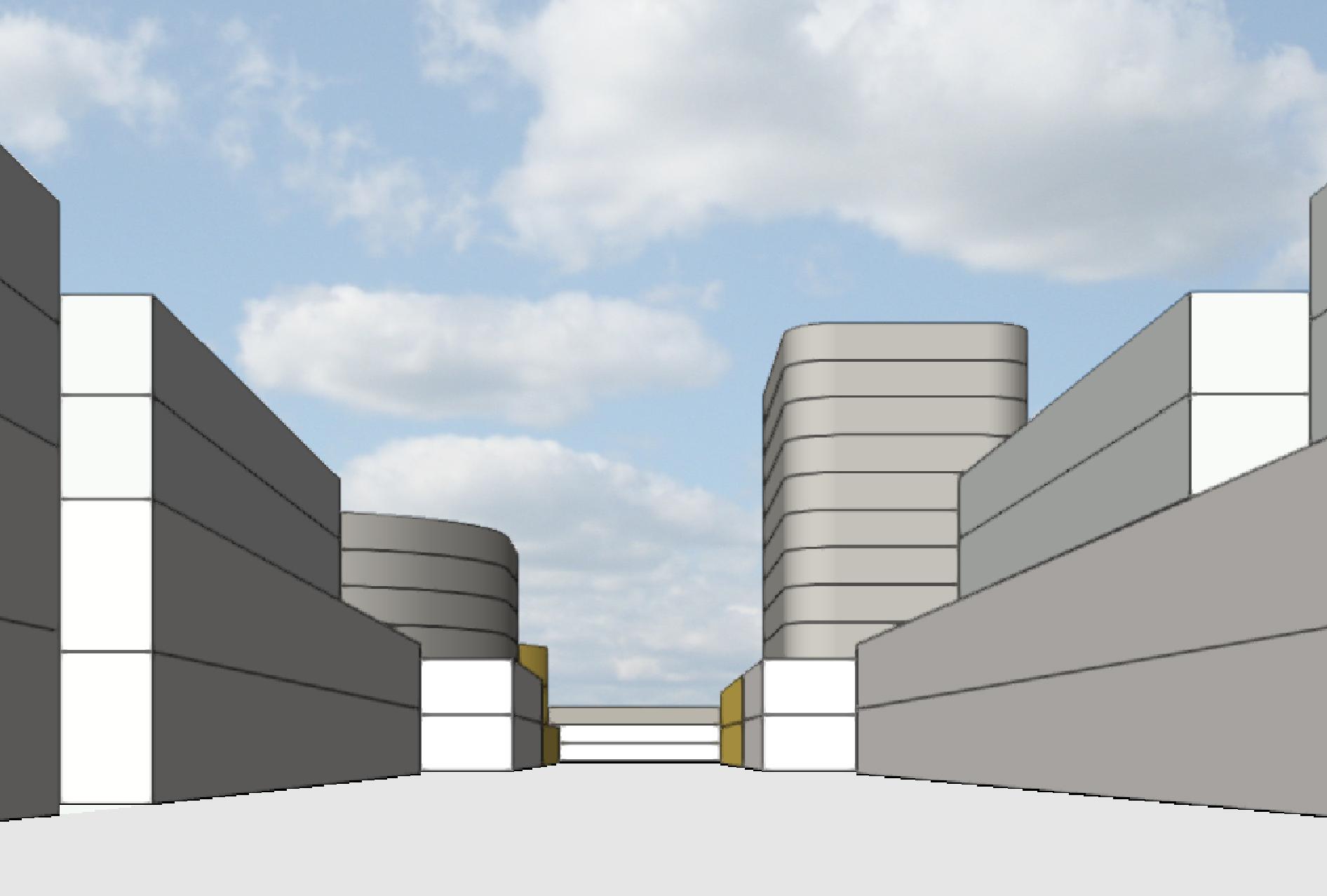
PLAN4002/UDES0002 2022 Louis Broadfield Wagga Wagga Urban Design Framework 4.5. Key Views Compact and Sympathetic Skyline Built form coalesces around the intersection of Baylis Street and Sturt Highway, tapering to meet existing buildings in surrounding residential areas. The interfaces of Baylis Street promote a strong north-south view corridor, drawing in pedestrians to the legacy city centre. View south on Baylis Street View north from Baylis Street from station