12 minute read
In the Footsteps of Timothy O’Sullivan: Rephotographing the 1869 King Survey in the Headwaters of the Bear River, Uinta Mountains


In the Footsteps of Timothy O’Sullivan: Rephotographing the 1869 King Survey in the Headwaters of the Bear River, Uinta Mountains
By JEFFREY S. MUNROE
Many students of nineteenth century exploration of the West are familiar with the Geologic Exploration of the 40th Parallel, which surveyed the route of the Transcontinental Railroad under the direction of Clarence King. Between 1867 and 1870 the King Survey examined the Comstock silver mine in Nevada, spent two months surveying the Great Salt Lake, and added greatly to our knowledge of the geology of the northern Great Basin. It is less widely known, however, that the King Survey also conducted a reconnaissance of the north slope of the Uinta Mountains. During this investigation, the immensely talented photographer for the King Survey, Timothy O’Sullivan, captured more than a dozen photographs of the High Uintas landscape in the headwaters of the Bear River. Today these photographs provide a unique perspective on what these pioneering explorers saw with their own eyes.

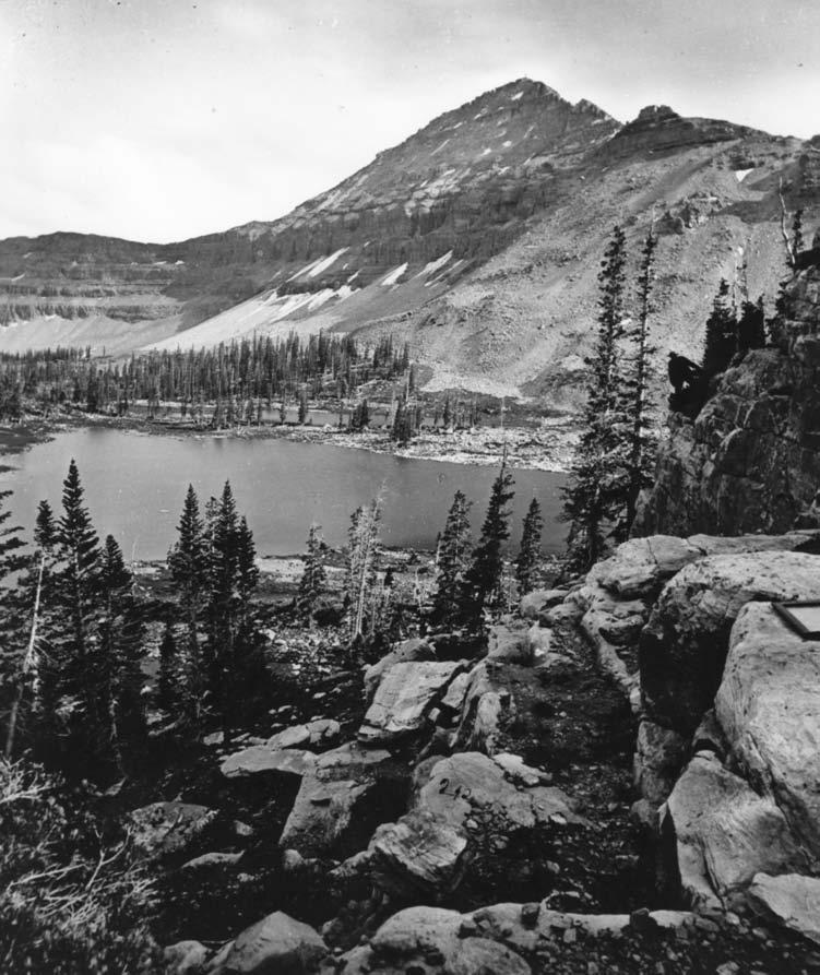
Lake Lal and Mount Agassiz, Uinta Mountains, Utah. Timothy O’Sullivan, 1869. (National Archives NWDNS-77-KW-212 ARC 519650).
The King Survey visited the Uintas in August 1869 near the end of their third year of fieldwork. From the vicinity of Evanston, Wyoming, they traveled south, ascending the Bear River towards its source in the jagged peaks east of the modern Mirror Lake Highway. A few miles south of the Utah-Wyoming line, they followed the Stillwater Fork of the Bear River away from the Hayden Fork, passing through Christmas Meadow and up into the Middle Basin. They eventually made camp at Ryder Lake, which they called “Lake Lal,” and commenced a multi-day exploration of the Middle Basin, including the area around McPheters Lake, which they named “Lake Jan.”

Mt. Agassiz over Ryder Lake. Jeffrey S. Munroe, August 16, 2004. This photopoint is near the top of the prominent quartzite ledges rising from the western shore of Ryder Lake. The ledges are considerably more forested now, with trees blocking much of the original view. This photograph was taken near the spot of the original, but with a slight shift to allow sighting around some of the new trees. Trees are also growing thicker on the opposite side of the lake. Note the field case lying on the rock (right side of the original photograph), and the figure on the cliff (in both photographs).
King was fascinated by the glaciated landscape of the High Uintas, and after months of working at lower, drier, elevations across the Great Basin, it is easy to understand why. His letters contain lucid descriptions of the scenery merged with geologic interpretation including: “The view from one of the upper summits is varied by open, green, Alpine pastures, varied by innumerable lakes of transparent water which occupy erosion-hollows of the old glacier beds.” 1 He also presents astute observations of the evidence for former glaciation of the Uintas in his final report, concluding that “…the Uinta [glacier complex] was therefore comparable with the present Alpine system, but decidedly grander in its accumulation of snow and ice.” 2
While the Survey studied the geology of the Middle Basin and cataloged evidence of the ancient glaciers, O’Sullivan documented the subalpine and alpine landscape around Ryder and McPheters Lakes. O’Sullivan first rose to prominence as a photographer during the Civil War, working with the preeminent photographer of the period, Matthew Brady. After the war, King hired him as the official photographer of the U.S. Geological Exploration of the 40th Parallel. Working with fragile glass plates and a complicated wet-collodion process, he produced spectacular landscape photographs and detailed views of scenes throughout the Great Basin. Many of his images have become icons of the West, famous for the stark manner in which they present a raw landscape, often appearing devoid of human influence. 3
In the Middle Basin, O’Sullivan’s eye was particularly drawn to the relationship between the lakes and the surrounding mountains. The majority of the photographs O’Sullivan made there show Mount Agassiz, Hayden Peak, or the ridgeline between them, along with some portion of the surface of Ryder or McPheters Lakes. 4 In many of his pictures, rocky peaks are reflected in a smooth water surface, producing a dramatic mirroring effect. As O’Sullivan circumnavigated Ryder Lake he also photographed panoramic views to the northeast across the headwaters of the Basin, including the profiles of Spread Eagle and Ostler Peaks.
O’Sullivan’s photographs from the Middle Basin are notable in that they capture the same scenic climaxes photographed by myriad visitors to the area over the ensuing decades. As the expedition’s official photographer, O’Sullivan was charged with documenting all aspects of the Survey’s observations and discoveries. Yet under the influence of such spectacular scenery he chose to record the dramatic sweep of the landscape instead of focusing on details of its geology. One could certainly argue that the two are inextricably intertwined, especially in the case of a landscape affected by alpine-style glaciation. But it remains striking how obvious the subjects of his compositions are when visiting the Middle Basin today.
Because the features O’Sullivan photographed are so recognizable, this collection provides a tremendous opportunity to envision changes in the subalpine environment over centennial timescales through “rephotography.” Specifically, by locating the positions from which O’Sullivan aimed his camera and rephotographing the scenes he captured, landscape changes can be identified over an interval of time that is long by human standards. This technique has been widely employed using photographs taken as part of the early western surveys. For instance, members of the Rephotographic Survey Project replicated dozens of O’Sullivan photographs (including at least four from the Middle Basin) in the 1970s. More recently, many O’Sullivan photographs were replicated for a second time by the Third View Project, along with a more complete documentation of the spatial and cultural context of the photopoints.5 To apply this approach in the Middle Basin, I acquired copies of fifteen O’Sullivan photographs from the National Archives and Records Administration and from the George Eastman House. These were rephotographed in July 2001, and in August 2003 and 2004, yielding fifteen photo-pairs, which are presented here, that document change and stasis in the Middle Basin landscape over more than 130 years. 6
Comparison of O’Sullivan’s photographs and the modern rephotographs allows two broad generalizations. First, although the composition of the subalpine fir and Engelmann spruce forest has remained constant, there are notably more trees on the landscape today. Almost all of the rephotographs illustrate that the forest is denser, with trees growing closer together. Krummholz, such as that seen along the shoreline of Ryder Lake in 1869, has also grown into upright mature trees over the years. In many instances, this new growth obscures the view from the former photopoint. Finally, many individual trees that feature prominently in the 1869 photographs are still alive, and tree growth has even expanded in seemingly less hospitable locations such as the ledges west of Ryder Lake and near McPheters Lake. Overall these results match those revealed by a similar rephotographic study from approximately twenty miles away in the north-central Uintas using photographs from the 1870 Hayden Survey. 7
On a local scale, forest health is influenced by numerous factors, including insects, disease, fire, and management decisions, and all of these have undoubtedly affected the subalpine forest of the Middle Basin in the past. However, the similarity of the changes noted in this study, and those revealed by rephotography of the Hayden Survey images, suggests that an agent capable of more widespread synchronous impacts is responsible. In the case of high-elevation forests, the upper limit of tree growth is ontrolled primarily by growing season temperature, and therefore climate change is the most likely candidate behind the differences noted in the rephotographs. Considered this way, the denser forest growing at higher elevations in the modern images suggests that summers have become warmer, allowing trees that were established in 1869 to persist, trees in formerly marginal settings to flourish, and new trees to germinate in previously inhospitable sites. The modern forest also contains fewer dead trees, suggesting that overall growing conditions are less rigorous today. These changes are understandable when one considers that O’Sullivan visited the Uintas not long after the culmination of the Little Ice Age, an interval of climatic cooling that led to glacier expansion and treeline depression nearly worldwide.8 Thus, at least some of the forest changes can be attributed to the natural warming that followed the Little Ice Age maximum ca. 1850. The abundance of young trees in some of the rephotographs, however, indicates that the climatic amelioration has accelerated in recent decades, likely in response to the accumulation of anthropogenic greenhouse gases in the atmosphere. 9
In contrast to the dramatic changes in the forest of the Middle Basin, physical aspects of the landscape around Ryder and McPheters Lakes have remained strikingly constant. Snowbanks appear in the same places, and several rephotographs reveal that conspicuous boulders remain in similar positions on the talus despite the passage of more than a century.At first this seems an unexpected result because a visit to the Middle Basin can easily yield the impression that this is a fairly active landscape; minor rockfall events are heard frequently during the summer, and the impressive amounts of snow that accumulate on the higher slopes encourage avalanching that could be expected to effectively modify the piles of scree. Upon reflection the message of this apparent contradiction becomes clear: even when the evidence is obvious, geologic changes remain difficult to grasp in the context of a human timeframe. Rocks steadily erode through processes that act too slowly for their effects to be appreciated in decades or centuries. Mount Agassiz and the other mountains surrounding the Middle Basin may be lower today than in 1869, and blocks on the talus may have shifted ever so slightly in response to minor rockfall.Yet most landscape changes occur through dramatic, infrequent events, and the more efficacious events are those that occur less frequently. Such events may still be encompassed within a uniformatarian framework if the time scale is long enough, but if one of these events occurs in a human lifetime it is considered “catastrophic” or “unprecedented,” with our choice of words revealing how tightly our comprehension of natural events is bound to our restricted human time frame. Rephotography offers a unique opportunity to transcend this limitation and to expand our appreciation of both time and rates of landscape change.

Map of the Middle Basin of the Stillwater Fork Bear River showing the locations of Ryder and McPheters Lakes and the O’Sullivan photopoints (identified by negative number). Selected topographic contours are shown, and the ridgeline enclosing the Basin is identified by the dashed line. The surface elevation of Ryder Lake is 10,640 ft, while McPheters Lake is at 10,843 ft.

Lake Lal, Summit of Uinta Mountains, Utah. Timothy O’Sullivan, 1869. (National Archives NWDNS-77-KN-166 ARC 519522).

Ridgeline and Ryder Lake. Jeffrey S. Munroe, June 24, 2001. This pair of photographs was taken along the north shore of Ryder Lake just west of the lake outlet. The width-of-field of the modern photograph is narrower than the original, so the extreme right side was not captured. Trees are growing in thicker clumps on the far side of the lake, but there is still considerable unvegetated talus. There is also a prominent area extending upward from the far shoreline between the two denser tree clumps that appears to contain less vegetation. Despite the different timing of the two photographs, the topographic control that encourages snowbanks to form in the same locations each year is obvious.

Lake Lal, Uinta Mountains, Utah. Timothy O’Sullivan, 1869. (National Archives NWDNS-77-KW- 219 ARC 519654).

Ryder Lake outlet. Jeffrey S. Munroe, August 16, 2004. This pair of photographs was taken at the northeast corner of Ryder Lake, where the Stillwater Fork of the Bear River begins. The low krummholz visible just to the right of the outlet in 1869 has grown dramatically upward, blocking much of the view from the original photopoint. To compensate, the modern photograph was taken a few feet to the south. Trees have also grown up on the far side of the stream. More emergent vegetation is present in the stream, and a new island has formed. Rocks on the stream bottom appear to be in the same positions. Note the two figures that appear to be fishing in the original photograph.

Lake Lal, Uinta Mountains, Utah. Timothy O’Sullivan, 1869. (National Archives NWDNS-77-KW- 222 ARC 519656).

Ridgeline and small lake south of Ryder Lake. Jeffrey S. Munroe, August 16, 2004. This photograph was taken from the east side of the small lake immediately south of Ryder Lake. Trees are growing thicker on the far right side, and smaller tree clumps appear more numerous in the background. The foreground shoreline has changed slightly, with more emergent vegetation, and erosion has uncovered part of a rock that was hidden in 1869.

Lake Lal, Uinta Mountains, Utah. Timothy O’Sullivan, 1869. (National Archives NWDNS-77-KW- 220 ARC 519655).

Looking north across Ryder Lake. Jeffrey S. Munroe, August 12, 2003. The section of shoreline along the southeast side of Ryder Lake has changed considerably. The rock the figure is sitting on in 1869 is still visible at the shoreline (center), but the leaning tree to the left of the figure has grown dramatically upward, and other trees have greatly obscured the original view necessitating a slight shift in the perspective of the modern photograph. The prominent staircase of cliffs in the distant ridgeline is still obvious, while the diagonal white rock in foreground of the original photograph is partially hidden by litter layer. The trees on the background ledges have also grown larger.

Mount Agassiz, Uinta Mountains. Timothy O’Sullivan, 1869. (GEH NEG: 9290 81:1888:0037) Courtesy George Eastman House.

North face of Mt. Agassiz. Jeffrey S. Munroe, August 12, 2003. This photograph was taken from the western end of the narrow ridge separating Ryder Lake from the small lake immediately to the south. Once again trees block the original photopoint, necessitating a slight shift in the position of the modern photograph. The foreground landscape has been greatly disturbed by treetip and the prominent tree in the right foreground in 1869 has fallen and rotted. More trees are visible on the far shoreline. The largest rocks on the talus appear in the same position.

Near Lakes Lal and Jan, Uinta Mountains, Utah. Timothy O’Sullivan, 1869. (National Archives NWDNS-77- KW-224 ARC 519658).

Ledges and Spread Eagle Peak. Jeffrey S. Munroe, August 16, 2004. This scene was photographed along the narrow outlet of the small pond south of Ryder Lake, which flows into the lake in the distance. More vegetation is visible overhanging the cliff, and trees are more numerous and more robust. Many loose rocks along the ledges are in identical positions, although some have disappeared.

View in Uinta Mountains. Timothy O’Sullivan, 1869. (GEH NEG: 50622 81:1888:0004) Courtesy George Eastman House.

The Middle Stillwater Basin. Jeffrey S. Munroe, August 12, 2003. This panoramic view looks northeastward over the headwaters of the Stillwater Fork Bear River from a position on the talus rising above the south side of the Basin. The lack of immediate foreground features made it difficult to locate the exact 1869 photopoint, however the perspective here is quite similar. The small pond south of Ryder Lake is visible at the extreme left of the 1869 photograph, while the ledges shown in the previous photograph are partially visible near the center. Trees are growing much thicker everywhere. Rocks at the foot of the talus in the foreground are in similar positions. Dead and downed trees in the foreground of the 1869 photograph are represented by linear concentrations of rotting wood (not obvious in the photograph).

View in Uinta Mountains. Timothy O’Sullivan, 1869. (GEH NEG: 33175 81:1888:0005) Courtesy George Eastman House.

View northeastward over Ryder Lake. Jeffrey S. Munroe, August 12, 2003. In this view from the ledges southwest of Ryder Lake, Spread Eagle Peak (12,540 ft) is visible on the right while Ostler Peak (12,718 ft) is visible in the background center. A new tree completely blocks the original photopoint so this photo was taken a few feet to the northeast; branches of the new tree are visible along the left margin of the modern photograph. The large downed tree visible in the lower left of the 1869 photograph (note figure for scale) is still present and notably intact in 2003. The tree appears larger due to the shift in photopoint. A photograph from a nearby point was taken by the Rephotographic Survey Project in 1979.

Uinta Mountains. Timothy O’Sullivan, 1869. (GEH NEG: 19427 81:1888:0017) Courtesy George Eastman House.

Ridgeline southwest of Ryder Lake. Jeffrey S. Munroe, August 12, 2003. This view looks westward from the ledges southwest of Ryder Lake at the dramatic ridgeline forming the wall of the Middle Basin. The prominent tree in the center of the 1869 photograph is still recognizable, and many other trees appear to have survived and grown during the intervening 134 years. Note that the large rocks visible near the top of the right talus cone are in the same positions.

Mount Agassiz, Uinta Mountains. Timothy O’Sullivan, 1869. (GEH NEG: 9293 81:1888:0010) Courtesy George Eastman House.

Mt. Agassiz over Ryder Lake. Jeffrey S. Munroe, August 12, 2003. The first of two similar scenes captured from the northwestern shore of Ryder Lake, looking southeast at Mt. Agassiz (12,428 ft). The forest along the far shore is considerably denser, and appears healthier with fewer standing snags. A photograph from a nearby point was taken by the Rephotographic Survey Project in 1979.

Uinta Mountains. Timothy O’Sullivan, 1869. (GEH NEG: 9288 81:1888:0002) Courtesy George Eastman House.

Mt. Agassiz over Ryder Lake. Jeffrey S. Munroe, August 12, 2003. The second scene captured from the northwestern shore of Ryder Lake. Again the forest along the far shoreline is denser and healthier. The prominent leaning tree in the 1869 photograph is obvious in 2003. A new tree has also grown up to block part of the extreme left-hand side of the modern photograph. Note the large white rock along the shoreline in the center of both photographs, which was useful in locating the photopoint.

Lake Lal, Uinta Mountains, Utah. Timothy O’Sullivan, 1869. (National Archives NWDNS-77-KW-215 ARC 519651).

Ryder Lake. Jeffrey S. Munroe, August 12, 2003. New trees almost completely block the view from this photopoint located to the west of the Ryder Lake outlet. These trees may be greatly enlarged versions of the krummholz that appears along the shoreline in the 1869 photograph. The striped (labeled) rock visible in the original photograph was hidden under branches in 2003.

Uinta Mountains. Timothy O’Sullivan, 1869. (GEH NEG: 46908 81:1888:0027) Courtesy George Eastman House.

Spread Eagle Peak over McPheters Lake. Jeffrey S. Munroe, August 12, 2003. This photograph was made from the extreme western end of McPheters Lake, located half a mile north of Ryder Lake. Spread Eagle Peak is visible in the background. The water level was lower in 2003, and other rocks are visible around the taller rock that was emergent in the 1869 photograph. Trees are growing denser on the ledges forming the far shoreline. A photograph from a nearby point was taken by the Rephotographic Survey Project in 1979.

Uintah Mountains.Timothy O’Sullivan, 1869. (GEH NEG: 50621 81:1888:0020) Courtesy George Eastman House.

Spread Eagle and Ostler Peaks over McPheters Lake. Jeffrey S. Munroe, August 12, 2003. This scene encompasses the length of McPheters Lake from a vantage point above the western shore. Spread Eagle (right) and Ostler (center) Peaks are visible in the background.The exact photopoint was difficult to locate, but this is a reasonable approximation. A small spring is present at this site, which may have provided a source of water for O’Sullivan to use in washing the exposed plates in 1869.Trees are more numerous on the ledges at left, and a new tree along the shoreline at lower right obscures the rock(s) in the water in the previous photograph. A photograph from a nearby point was taken by the Rephotographic Survey Project in 1979.
NOTES
Jeffrey S. Munroe is professor of geology at Middlebury College, Middlebury, Vermont.
1 R.A Bartlett, Great Surveys of the American West (Norman:University of Oklahoma Press,1962),178.
2 C.King,Systematic Geology,Vol.I in the Report of the Geological Exploration of the 40th Parallel (Washington D.C.:U.S.Government Printing Office,1878).
3 An excellent critique of O’Sullivan’s photography is provided by Joel Snyder “Aesthetics and documentation:remarks concerning critical approaches to the photographs of Timothy H.O’Sullivan”in Peter Walch and Thomas Barrow ed., Perspectives on Photography (Albuquerque:University of New Mexico Press, 1986).For further discussion of O’Sullivan’s photography see William L.Fox, View Finder:Mark Klett, Photography,and the Reinvention of Landscape (Albuquerque:University of New Mexico Press,2001).
4 Louis Agassiz was a Swiss geologist who compiled evidence from the Alps for his theory of Ice Ages proposed in his masterwork Etudes sur les glaciers,published in 1840.In 1847 he accepted a professorship at Harvard University.Ferdinand Vandeveer Hayden led the Hayden Survey that explored the Western United States (including the northern Uintas) throughout the 1870s.
5 M. Klett, E. Manchester, J. Verburg, G. Bushaw, and R. Dingus, Second View: The Rephotographic Survey Project (Albuquerque: The University of New Mexico Press,1979).M. Klett, K. Bajakian, W.L. Fox, M. Marshall, T. Ueshina, and B. Wolfe Third Views, Second Sights: A Rephotographic Survey of the American West (Santa Fe: Museum of New Mexico Press,2004).
6 To facilitate comparison between the paired photographs,I obtained 300 dpi .jpg files of photographs from the George Eastman House [www.eastmanhouse.org/] and scanned copies of the National Archives photographs (printed at 8x10 in) on a flatbed scanner.For the modern photographs,I used either a) digital images taken with a wide-angle lens (for photographs with a portrait orientation),b) scanned negatives (with scratches and dust removed manually in Corel PhotoPaint),or c) scanned negatives combined into a panorama view with Panorama-Maker (for photographs with an extremely wide field-ofview).All of the digital image files were scaled to publication size and resampled to 400 dpi.Financial support from Middlebury College and the American Alpine Club and field assistance from D.Berkman,E. Carson,and C.Rodgers are greatly appreciated.
7 J.S.Munroe,“Estimates of Little Ice Age climate inferred through historical rephotography,northern Uinta Mountains,U.S.A,” Arctic,Antarctic and Alpine Research 35 (2003):489-98.
8 A thorough discussion of the Little Ice Age is provided by Grove,Jean M., The Little Ice Age (New York:Routledge,1990).
9 Intergovernmental Panel on Climate Change Fourth Assessment Report,2007.


