56 minute read
Home Rule: The Struggle to Create Duchesne County and Its County Seat


Home Rule: The Struggle to Create Duchesne County and Its County Seat
BY CRAIG FULLER
During the later stages of struggle between residents of Heber Valley and recent homesteaders on the former Uintah Indian Reservation to carve out a new county from the eastern portion of Wasatch County, Heber City’s Wasatch Wave editorialized in 1914 in support of the creation of Duchesne County: “Counties are created for the convenience of the people residing within their territorial boundaries in the transaction of civil business and to facilitate local self-government.” 1 The creation of Duchesne County and the location of its county seat would take years of meetings and discussions among Heber Valley residents, Uinta Basin homesteaders, local leaders, Wasatch and Uintah County officials, and involve several legislative enactments and state-wide plebiscites. Several important issues brought Utah’s attorney general, state engineers, county surveyors, and others, to help broker compromise among interested parties. Mixed in were cultural differences among the homesteaders on the former Indian reservation and a power struggle to control the county through the location of This paper will review the county seat. background and reasons why Uinta Basin residents sought to establish a county of their own, and the issues and problems they faced in the creation of Duchesne County. 2 Wasatch County, the mother county for both Uintah and Duchesne counties, was created in 1862, and included most of the expansive Uintah and Uncompahgre Indian Reservations. Following the settlement of Ashley Valley, the territorial legislature in 1880 created Uintah County from the extreme east end of Wasatch County and designated the 110th Meridian as the Wasatch-Uintah county boundary. 3 Twenty-five years later in August 1905, following the federal government’s policy of converting Indian reservations into individual Indian farmsteads and opening the balance of the land to white homesteaders, Utahns and others participated in the largest land grab in the state’s history.Thousands of would-be homesteaders rushed to takeup land on the former Uintah Indian Reservation. 4

Main Street, Myton, Utah. Former sub-Indian agency contends for the county seat.
USED BY PERMISSION, UINTAH COUNTY LIBRARY REGIONAL HISTORY CENTER, ALL RIGHTS RESERVED
Within months, following the opening of the Uintah Indian Reservation, homesteaders began clamoring for “home rule.” In January 1906, George W. Emerson and forty-two other homesteaders petitioned the Wasatch County Commission for a schoolhouse in Myton. The commissioners acted quickly and instructed the county attorney to prepare an ordinance for a new school district to “embrace all that part of the county formerly embraced within the Uintah Indian Reservation.” 5 The operation of the new school district, serving grades one through eight, brought heavy financial demands for the homesteaders in the Basin as well as on the other residents of the county.

Homesteaders take up land on the former Uintah Indian Reservation, circa 1906.
UINTAH COUNTY LIBRARY REGIONAL HISTORY CENTER, ALL RIGHTS RESERVED
High schools by state law were limited to the several large cities in the state but in 1909 the state legislature expanded the establishment of high school districts throughout the state with several restrictions, one of which was a minimum population of five hundred students. Wasatch County had the minimum number of students and soon the Wasatch County commissioners created the countywide Wasatch High School District with the building located in Heber City. 6 The establishment of a high school district in Wasatch County failed, however, to resolve east-end parents’ desires for education for their older children. Distance and poor roads, especially during much of the school year, prevented older students from attending the high school. One option for Basin parents was to board their children in Heber City during the school year. However, for most east-end families this added to an existing financially encumbered family condition. For settlers already faced with establishing their homesteads and the financial panic of 1907, boarding their older children in Heber City meant the loss of critical labor, very much needed on Basin farms. The east-enders heavy financial burdens were so desperate that Governor John C. Cutler requested an exceptional appropriation from the state legislature in 1907 to assist Uinta Basin homesteaders. 7
The homesteaders’ financial woes continued with a poor fall harvest in1908, followed by an extremely hard winter.“[I]t is reported that there is great suffering among the settlers from hunger and cold, and that hundreds of people there are on the verge of actual starvation,” warned John Moffitt, a member of the Wasatch County Commission.“[V]ery little was raised last season on the newly made farms…. Hundreds of people there have no money with which to buy food and clothing…and unless aid is extended to the settlers in some way the results are going to be serious.” The county commission received another $7,500 in relief funds from the state legislature to aid the needy east-end homesteaders. 8

Wood bridge across Duchesne River at Myton, 1907. East enders requested additional funds for road and bridge improvements.
USED BY PERMISSION, UINTAH COUNTY LIBRARY REGIONAL HISTORY CENTER, ALL RIGHTS RESERVED
Determined to educate their older children and facing continued financial hardship, east-end parents petitioned the county commission for a second high school district to serve their end of the county. The county commission, acting on recommendations from county school superintendent David A. Broadbent, recommended that a second high school district be created with its boundaries to include all of the territory between the county’s eastern boundary and “God [’s] established line”—the Wasatch Mountain Range. 9 A countywide vote was necessary for the new high school district to be created and William Buys, editor of the west-end Wasatch Wave newspaper, urged property owners to cast their votes favorably for the new high school district.There would be no additional taxes for residents living in the west end of the county, the burden to build the high school and pay the teachers rested on the shoulders of the citizens in the east end of the county. Citizens gave their approval for the high school district and a second election, limited to residents of the second high school district, was held to select the location for the second high school. Campaigning for the high school building was intense between the two leading communities of Roosevelt and Myton. Religious persuasion and moral standards were important issues as Myton and Roosevelt town folks campaigned to win the approval of the voters for the new high school building. Even more was at stake, as the town that secured the high school would be favored to become the county seat if an attempt was made to create a new county out of eastern Wasatch County.

New steel bridge across Duchesne River at Myton, 1910.
USED BY PERMISSION, UINTAH COUNTY LIBRARY REGIONAL HISTORY CENTER, ALL RIGHTS RESERVED
Myton, a former Indian sub-agency community with an existing non- Mormon population, had a thriving commercial base and accommodations for the thirsty, hungry and tired travelers on the Nine-Mile Road between Price and Vernal. William B. Smart, president of the newly formed LDS Duchesne Stake, was opposed to locating the high school in Myton as were members of the Roosevelt Commercial Club who cautioned, “that owing to local conditions at Myton it would be unwise for the school to go there,” adding it would be our “duty to work for it here [in Roosevelt] in our cleaner moral government.” 10
By a slim seven-vote margin, east-enders selected Roosevelt for their new high school building. 11 To insure a victory for Roosevelt, William Smart earlier agreed to sell a choice parcel of land to the high school district for the high school. Securing the high school was an important step for Smart and others to make Roosevelt the center of commerce and education. 12 The vigorous campaign for the high school building portended an equally energetic struggle among residents over county boundaries and the location for local government.
Good roads, like education were an important factor for the region’s economic vitality.The lack of good roads and bridges was another problem between east- and west-enders. The first roads on the former reservation were built by the U. S. Army to connect Fort Duchesne with the newly established railhead at Price. A second but less traveled road especially during winter months was through Strawberry Valley—the Daniels Canyon road. 13 East-enders who used the Fort Duchesne to Price road to travel to Heber City to conduct county business required several days travel each way by wagon, horseback or stage to the railhead at Price, then by rail to Provo and a transfer to the Heber City rail line.
Travel to Heber City was time consuming and costly and frequently the complaints from the east-enders were that the county had not adequately funded for road and bridge improvements on the former reservation especially through Strawberry and Daniels Canyon. Limited financially, the county commission appealed to the state legislature for assistance and in 1907 the county received a special sixteen thousand dollar appropriation for roads and bridges on the former reservation. Even with this special appropriation, loud howls from east-enders continued as they felt the county had not shared the funds as the legislature intended. Disturbed from the continued crying from the east end of the county, the Wave defended the commission’s actions: “There ought not to be any petty sectional jealousies among the people of this county; they cannot afford it.” The newspaper added that the east-enders had received more than their fair share of county funds for roads, bridges and other expenses. 14 East end residents remained dissatisfied and the state legislature funded another special appropriation in 1908 of eleven thousand dollars for roads and bridges for the east end of the county. 15 While road improvements were being made, the real underlying issue that festered among the east-enders was their geographical isolation from the seat of power.

Theodore (Duchesne), Utah, 1910, contends for county seat.
USED BY PERMISSION, UINTAH COUNTY LIBRARY REGIONAL HISTORY CENTER, ALL RIGHTS RESERVED
Changes made by LDS church leaders in Salt Lake City to ecclesiastical administration on the former Indian reservation contributed to the widening breach between the two ends of the county. In 1906 a dozen newly organized LDS wards and branches were separated from the Wasatch Stake and placed in the Uintah Stake headquartered in Vernal. 16 William Smart was released as president of the Wasatch Stake and installed as the stake president of the enlarged Uintah Stake. Four years later, Smart recommended to LDS church president Joseph F. Smith that a new stake of wards and branches located on the former Indian reservation be organized. Apparently following the recommendation of Smart, the church created Duchesne Stake in 1910. Smart was released as stake president of the Uintah Stake and sustained as president of the new Duchesne Stake with its headquarters in Roosevelt. 17 (The new stake’s boundaries, uncertain as they were, would be a factor when it came to locating Duchesne County’s boundaries.) For Smart and others, selecting Roosevelt as the religious center was yet another reason to locate the local civil government in Roosevelt. 18

Main Street, Vernal, 1910, county seat of Uintah County.
USED BY PERMISSION, UINTAH COUNTY LIBRARY REGIONAL HISTORY CENTER, ALL RIGHTS RESERVED
Even as the LDS stake headquarters and the high school were being located in Roosevelt, Smart and other east-end community leaders were laying plans for the temporal affairs for the former Indian reservation. Smart envisioned the eastern portion of Wasatch County divided into four civil districts, each with two representatives to aid in governing the Uinta Basin portion of Wasatch County. 19 Smart believed that each of these districts would eventually be transformed into counties, dominated by Mormon church members. (It is unclear whether Smart intended to include Uintah County in his multi-county plan.)
Developments for the creation of new county in the Uinta Basin were moving on another front. Representative John T. Giles from Heber City introduced a bill in the state legislature in 1907 to permit the creation of new counties. 20 His bill failed in committee but a substitute bill, House Joint Resolution 10, passed, which would have given the legislature the “power to enact laws creating new counties out of territory taken from one or more of the existing counties” and would have defined the “duties and obligations of any such new county between itself and any county from which territory is taken.” The legislature, somewhat cautious about granting itself too much power without the support of the voters and without including in the county making process the will of county residents, voted against this bill as well. A third resolution, Senate Joint Resolution 4, to authorize the state legislature to create new counties, was placed before the voters on the November 1908 ballot for their ratification. Here was the first opportunity for Basin residents to secure home-rule.
As the statewide campaign began, the Uintah Chieftain (Myton) urged voters to approve the amendment. It pointed out that it would give the residents of eastern Wasatch County “something to say regarding the management of public affairs in Wasatch County.” And, it re-emphasized the long complaint that it often took from “four to ten days” and distance from “100 to 300 miles over very bad roads” to travel to Heber City to conduct business. For the Myton newspaper editor the choice was clear—create a new county or relocate the county seat to the Uinta Basin. 21 The Wasatch Wave responded angrily to the Myton newspaper’s apparent threat that “If anyone from this end of the county [Heber Valley] has been abusing them [east-enders], he should be called to account at once.” And then it added that the east end of the county was “prov[ing] to be rather an expensive luxury…” for the rest of the county. 22
To build local support for home rule and approval of the constitutional amendment, a political meeting was convened in Myton to urge voters to support the amendment and “to take some action that would result in giving the reservation its just proportion of political power” in the county. 23 West-enders increasingly were growing weary of the snipping and threats that they dominated Wasatch County politically. “We west-enders,” wrote the Wasatch Wave, “are now more than willing to help the pioneers of the Uintah Basin in every way possible…. [We] do not appreciate the threat to take control of the affairs of the county, financially and politically and tax this end of the county to build up the reservation end, without even asking their permission” 24
Concerned with a growing “diversity of opinion[s],” about the upcoming election and how the new county should be organized following passage of the constitutional amendment, Smart was anxious to gain support from all local church leaders in the Basin. 25 At a meeting with the Uintah Stake high council, all but two of its members supported the amendment and the idea of creating a new county. Smart, along with Joseph R. Murdock, Reuben S. Collett, Edward Clyde, Alva M. Murdock, Dan Lambert, and Harden Bennion, also met with church president Joseph F. Smith and other church leaders to encourage their approval for the amendment and their efforts to create a new county. Smith “heartily endorsed” their efforts and presumably the constitutional amendment as well. 26
As the November election drew nearer, the proposed amendment generated much discussion in the county and elsewhere in the state. William Buys, editor of the Wasatch Wave cautioned county voters not to give too much power to the legislature in such matters.
The larger Salt Lake City daily, the Deseret News, urged voters to support amendment three: “the new Uintah Settlements [should] enjoy a county government of their own.” 28 The Salt Lake Herald, however, opposed the amendment. It, like the Heber City newspaper, feared that too much power would be placed in the hands of the state legislature and clearly identified what would happen if the legislature had sole authority to create new counties. “The proposed amendment is objectionable because it would pave the way for `gerrymandering’ in the future. [And] of political manipulations of boundaries is so strong that the constitutional provision now existing should be retained and the proposed amendment voted down.” 29 Weighing in on the amendment, one eastern Utah citizen penned:“I think it would be well to remember that the people should rule and where the majority of the people living in a particular territory are opposed to the slicing up of counties no legislature should have the right to override their wishes.” 30 The Salt Lake Tribune joined the chorus and urged voters to vote “No on the proposed constitutional amendments.” 31
Statewide, the amendment failed by a wide margin: 16,222 to 9,770, but Wasatch County voters approved the amendment by a narrow six vote margin: 420 to 414. However, Heber Valley voters, apparently heeding the cautionary voice of William Buys authorizing the state legislature the sole power to create new counties, opposed the amendment, 386 to 162 votes. East-enders, on the other hand, overwhelming supported the amendment with a count of 258 for and 28 against. 32
East-enders faced a significant setback as a result of the state voters rejecting the amendment. Leaders in the Basin remained determined, and set to work organizing new committees including a committee in Heber Valley to formulate a new proposal to secure the legal means to divide the county. During the 1911 session of the state legislature a delegation of commercial clubs from the Basin met with some of the legislators to convince them that a new county was wanted and needed in eastern Utah. 33 Strong support for their plans came particularly from Uintah County representative Byron D. Nebeker. Nebeker understood any power to create new counties must be derived from the state’s constitution. “That a new county should be made is a fact that none can reasonably dispute…and I feel certain that it will be done even though an amendment to the constitution is necessary.” 34
Responding to Nebeker’s suggestion, Representative James B. Wilson from Midway was successful in getting passed a proposed constitutional amendment, which would be placed before the voters again. This time there were several provisions in the amendment, which were not included in the previous constitutional amendment: the new county residents would remain proportionally responsible for existing county debts of the older county, and the new county would have to be approved by two-thirds of the qualified property owners in the new and old counties. Here, then, the residents of the proposed new and existing counties would have to approve the creation of a new county. The constitutional amendment was placed on the November 1912 ballot.

Altonah commercial district, contends for county seat.
USED BY PERMISSION, UINTAH COUNTY LIBRARY REGIONAL HISTORY CENTER, ALL RIGHTS RESERVED
For the next months residents of both sections of Wasatch County faced numerous difficult tasks, including establishing the boundaries for their new county and selecting a county seat. For some the county lines matter was simple: the new county lines should mirror the boundaries of the newly established Duchesne Stake. However, when the stake was established its boundaries were ill defined and uncertain. To clarify these ecclesiastical boundaries, Smart met with Don B. Colton, president of the Uintah Stake to discuss their mutual stake boundaries and both agreed that the common boundary line between the two stakes should be “three miles east of the Uintah special meridian or the first section line west of the west boundary of the Fort Duchesne Military Post.” 35 Smart, however, wanted confirmation of the stake boundaries from church headquarters. The opportunity for clarification came in September 1911 when the quarterly stake conference of the Duchesne Stake was held with visiting church official, apostle Francis Lyman, officiating. Lyman clearly outlined Duchesne Stake boundaries. 36
The Uintah County Commission, learning of the plans of Smart and others to use the ecclesiastical boundaries for the county’s boundaries, opposed the plan. They insisted that Uintah County’s western boundary should include the territory known as “The Strip,” which was rich in gilsonite as well as some of the better-irrigated land along the Uinta and White Rocks rivers. Some such as Charles B. Bartlett, a resident in the west end of Uintah County, had their own ideas of where the Uintah-Duchesne County line should be located. He suggested that the Duchesne County line be located as far east as the Asphalt Ridge,“where the Creator intended it should be.” 37
As the statewide elections drew nearer the issues of the location of the county lines and the location for the county seat remained unresolved. Elsewhere in the state, there was growing concern about the amendments. The Deseret News urged voters to cast their votes against the amendment as well as the other three amendments on the ballot. Since, “some of …the opinions of those fully qualified to judge are divided, and therefore furnish no guide to the laity. We believe the general impression is that it is safest under the circumstances to vote `No’ this time.” The Heber City newspaper urged its readers to vote for the amendment. “[I]t will mean much to Wasatch County, for…both ends of the county will be benefited in many ways by the division.” 38 The Salt Lake Herald- Republican ran a paid political ad supported by both state political parties, which supportedthe amendment. 39 The amendment appeared to be a sure thing, but statewide voters soundly defeated the amendment by a rather substantial margin: 22,132 to 12,966. Wasatch County voters, however, overwhelmingly supported the amendment, 1,827 for and only 59 against it. 40

William Henry Smart, civic, religious leader and promoter of the Uinta Basin.
UTAH STATE HISTORICAL SOCIETY
Disappointed once again with the outcome, east-enders resumed their efforts to secure home rule. Early in 1913 as the state legislature met for its biennial session, Smart met with Governor William Spry, and members of the First Presidency of the LDS church, and “some of the ablest attorneys in the state” to drum up support for another constitutional amendment. From these meetings Smart learned that an amendment to the constitution was not necessary, but a well-written law was all that was needed. However, LDS church attorney F. S. Richards cautioned Smart that such a law would likely be tested in court. 41
With this advice carried back to the Uinta Basin, voters this time requested Representative William L. Van Wagoner from Midway and Senator L. B.Wight from Park City to draft a law to create new counties. Their bill, “Manner of Creating a New County out of an Existing County,” required 25 percent of registered voters from the proposed new and existing county to petition the county commission to hold a special election in July 1913 for the purpose to divide Wasatch County. Unlike earlier legislative efforts, this bill required that the new county’s boundaries had to be agreed upon by a majority of citizens of the new and existing counties before the special election. Further, the bill outlined that all obligations and indebtedness which had been incurred prior to the division of a county or counties, would be shared with the new county. And the bill stated that expenses incurred for holding special elections and recording necessary records would be paid for from the state’s general funds, and that all existing sub-divisions and boundaries within the new county would remain unaltered.
As the various boundary proposals were put forth for discussion, all proposals ignored the legal line established by the territorial legislature in 1880, the110th Meridian surveyed by federal land surveyor Charles DuBois in 1875. Further, there was some question about the location of the 110th Meridian.
Years earlier in 1907, at the behest of the Wasatch County Commission, Ed F. Harmston, a surveyor, was asked to examine the DuBois 1875 calculations. Harmston determined that the DuBois survey line was 2.2 miles shy of the 110th Meridian or at 109 degrees, 57 minutes, 30 seconds west longitude. The re-examination of Harmston’s 1907 calculations and that of the DuBois survey raised another question: Was Roosevelt actually in the proposed new county?
The location of Roosevelt and its residents’ desire for it to be the county seat added to the problem of locating the county’s eastern boundary as well as the would-be county’s western boundary.
The two leading contending communities for the county seat location were Myton and Roosevelt neither centrally located geographically, a highly desirable factor many Basin residents reasoned. Even though Roosevelt had secured for itself the high school and the LDS church’s stake headquarters, the Myton Commercial Club contended that Myton was the town of commerce and businesses, had served as an Indian sub-agency on the former Uintah Indian Reservation, and now with the new steel bridge across the Duchesne River in place Myton was accessible from all parts of the Basin. 42
Smart was strongly opposed to Myton and viewed H. C. Means, head of the Myton Commercial Club and many of the club’s members as being highly “intoxicated with a desire to rule.” Reflecting the growing cleavage between Mormon homesteaders and others, Smart wrote about Means and members of the Myton Commercial Club as “not Utah men. [M]y soul is…against this new section of Utah being un-righteously governed and controlled by them, and God being my help it shall not be so.” 43
For a brief time, the cleavage between “Utah men” and non-Utah men was set aside as the county line issue became more pressing. For years west-end farmers and ranchers had been grazing as many as two hundred thousand head of sheep and hundreds of head of cattle in Strawberry Valley and the nearby mountains. Irrigators from Heber Valley had for three decades diverted water from the Strawberry River to their thirsty farms in the Lake Creek area. 44 Water and grazing land were important resources for many Heber Valley farmers and ranchers and it was their desire to maintain control of these and other resources.

Birdseye view, Duchesne, county seat of Duchesne County.
USED BY PERMISSION, UINTAH COUNTY LIBRARY REGIONAL HISTORY CENTER, ALL RIGHTS RESERVED
To hammer out the Wasatch-Duchesne County line, committees from Heber City and the Uinta Basin were organized. Dr. H. R. Hatch, Chase Hatch, J. R. Murdock, and George Barzee, members of the Heber Development League, represented the interests of the west-enders. The east-end committee included William Smart, Alva M. Murdock, and John A. Fortie with H. C. Means of Myton serving as the chair of the joint committee meetings. Among the several east-end proposals presented to the joint boundary committee was that the Wasatch- Duchesne county line be located nine miles west of present-day Fruitland. A second east-end proposal located the boundary even further west to what many called the “snow barrier”—the summit of the Wasatch Mountains. The west-end committee, following the instructions from the Heber Development League, flatly refused the second proposal. The west-end committee was adamant that it would, “not … take less than the territory embraced within the boundaries of the Wasatch County High School District No. 1.” 45
Fearing that no agreement would be reached and that an impasse would preclude holding the approaching election to divide the county, Smart once again met with Mormon church president Smith, apostle F. M. Lyman, and church patriarch Hyrum G. Smith and asked them to take the matter “before the Lord.” 46 Meanwhile, the west-end committee met with Wasatch Stake president Joseph R. Murdock and others. Murdock proposed a compromise line which would divide the disputed territory equally and that a compromise county line would be drawn down the center of Range 9 West of the Uinta Special Meridian. His proposal would ensure that the west-enders would remain in control of large deposits of coal, that livestock men would remain in control of much of the summer grazing land in the Strawberry Valley and surrounding mountains, and that farmers on the east side of Heber Valley would remain in control of diverting water from the upper Strawberry River to their thirsty land.
The joint boundary committee agreed to Murdock’s proposal. The Duchesne-Uintah County boundary seemed also settled as stated earlier by the 1880 territorial legislature, which was the 110th Meridian. A petition was then circulated to place the issue of creating Duchesne County on the special July 1913 ballot. 47 The editor of the Wasatch Wave expressed the prevailing sentiments of the voters of Heber Valley: “Let the matter be decided peaceably and when decided let it stand as the will of the people no matter which way it goes. We await the verdict of the people.” The Vernal Express urged the east-enders to “Vote in favor of the new county it is a necessity.” 48
The outcome of the vote, however, was far different than what was expected. West-end voters rejected the proposal: 721 votes against and 474 votes for division. East end voters overwhelmingly supported the division and the compromise boundary line by a plurality of 518 votes (651 to 133). Of the thirteen voting precincts in the east end of the county, voters in three east end precincts voted against the proposal—Stockmore precinct 14 for and 20 against, Fruitland 6 for and 8 against, and Myton 62 for and 67 against. 49
East-end community leaders were at a loss to explain the rejection by most west-enders as well as from some of their own. The Vernal newspaper proffered a possible answer, at least for the Myton voters. 50 Myton residents feared that they would not likely secure the county seat, which was being hotly contested by Roosevelt and themselves. The few Fruitland farmers and ranchers in the district were opposed to the possibilities of owning land in two counties and wanted to protect their interests. One unidentified Fruitland resident gloated: “Isn’t it surprising that Fruitland should all at once be so valuable? Long have the sheep men kept the value of our precinct in the dark but now that they are ready to bring it to the light. If you want to know what those values are call around ‘seeing is believing.’” A government report supported Fruitland’s claim. “[T]he Uinta Forest this season has had the best grazing range. At the time sheep enter forest grazing land, the feed in some parts is so rank that it covers the backs [of sheep] and they are so hidden by the grass and weeds upon which they feed that it is impossible to get a photograph of them.” 51 Other government reports estimated eight million tons of coal near Fruitland, and potentially four thousand acres of irrigable land—all taxable.

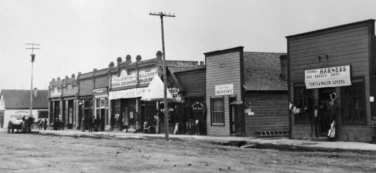
Roosevelt’s Main Street, important commercial and religious town on former Uintah Indian Reservation, 1910. Contends for county seat.
USED BY PERMISSION, UINTAH COUNTY LIBRARY REGIONAL HISTORY CENTER, ALL RIGHTS RESERVED
For most Heber Valley voters their reason for rejection was wanting to maintain control of as much of the Strawberry Valley and territory as far east as possible. However, voters in the two Midway voting precincts, dominated by dairy farmers, were less concerned with Strawberry Valley and more concerned with preserving their claims to water from Snake Creek. 52
Some west-enders believed that the division of the county would diminish state appropriations to their county. However, in the case of road funds, Charles J.Wahlquist revealed otherwise. Using appropriations from the state to the counties for road and bridge construction and maintenance for 1913, he calculated that Wasatch County and every other county in the state would have received $3,600 from the state legislature. Divided equally between the two ends of the county, each would have received only $1,800 for roads. However, if Duchesne County were in existence in 1913, each county would have received $3,471, or nearly doubling the road appropriation to both counties. He also pointed out that the proposal was the best that could be achieved and if the division did not occur now it would be much more difficult for the county to be divided in the future. 53
There was also some misunderstanding at both ends of Wasatch County that neither it nor the new county would have adequate taxes to operate their respective counties. However, the Heber City newspaper reported that the probable property taxes to be collected after the division would be at least $1,899,000 for Wasatch County, and in excess of $1,284,000 for the new county, adequate for each county. 54
Of more concern for east-enders than the lingering questions over taxes, boundary lines, and the struggle for power in the east end, was that the legislature might repeal the law authorizing the creation of new counties. To be successful, east-enders came to the conclusion that it was best to “Unite to Divide.” 55
By spring of 1914 there was evidence from the west end of the county that voters there were willing to accept a compromise line. 56 Once again a petition was submitted to the county commission to place the creation of Duchesne County on a special election for July 1914.This time the results were what the east end wanted: the east end overwhelmingly supported the proposition by an 8 to 1 margin—783 to 98 votes—and the west end supported the division with a narrower 2 to 1 margin—851 to 425 votes.
There remained yet one more important task for the residents of Duchesne County—the selection of a county seat. In September representatives from the county’s nine voting precincts met to hold a straw poll to select their county seat. Prior to the meeting, William Zowe, Myton’s chairman of the campaign committee to win support for Myton, suggested that, “It would be fatal for the county [to] have a county seat not located in the county.” 57 Zowe’s message was that Roosevelt was not in the county but that the Duchesne/Uintah county line was just west of Roosevelt. Roosevelt residents were dismayed and charged Zowe and others with a political “trick [to] win votes for Myton” for the county seat. 58
Zowe’s argument rested on the DuBois survey. To counter Zowe’s argument surveyor Ed F. Harmston at the request of the Wasatch County Commission in 1907 re-calculated the DuBois survey. He discovered that DuBois’s survey line was about 2.2 miles shy of the 110th Meridian and both the Uintah and Wasatch county commissions approved Harmston’s calculations, which placed Roosevelt just within the new county. 59
Through a series of straw ballots Lakefork, Banner, Bluemesa, and Altonah were eliminated leaving Myton and Duchesne in the running.The community of Duchesne was chosen to be the county seat by those holding the straw vote. 60
H. G. Clarke of Myton following the outcome of the meeting requested Heber City attorney Charles J. Wahlquest for his legal opinion about the location of the Duchesne/Uintah boundary. Wahlquist in-turn asked state engineer W. D. Beers for his opinion. Beers’ response was that the state engineer’s office recognized Harmston’s survey of the then Wasatch/Uintah line to be accurate, as did the state legislature in 1907 when it confirmed the Wasatch/Uintah county line to be the 110th Meridian. 61
The debate in Duchesne County of whether Roosevelt was or was not in Duchesne County and which line was the Duchesne/Uintah county boundary drew in residents from Uintah County. Some Uintah County residents feared that they would be annexed to Duchesne County. We are “not interested in the county seat fight…neither [do we] care which town is successful in securing the county seat but we are opposed to having a ten mile strip cut off the western side of Uintah County….” 62
As the election to select the county seat drew nearer, rhetoric over the location of the county seat grew heated. The Roosevelt newspaper charged that neither “malicious rumors” nor “political attacks” from the people of Myton or from any other “government” town would deter Roosevelt from being selected as the new seat of county government. Campaign literature urged, “A vote for Roosevelt…means a vote for economic and immediate good county government.” 63
Returns indicated that county voters had selected Roosevelt as their county seat. However, Duchesne town resident Rock Pope was dissatisfied with the tally and requested the Heber City judge to order the Wasatch County Commission to conduct a recount. Pope believed that many of the ballots from his town of Duchesne had not been counted. Pope’s suspicion was confirmed and the recount of all of the ballots overturned Roosevelt’s victory in favor of the community Duchesne City. 64
All now seemed to be in order for the legislature to designate Duchesne County as Utah’s newest county and the county seat to be the community of Duchesne. However, the question over the location of the Duchesne/Uintah boundary lingered. Early in January 1915 the Vernal Express received a report that Uintah County surveyor Nile Hughel had been at work resurveying the new Duchesne/Uintah line. His survey indicated that the county line was one mile further west than where it was supposed to have been. If his survey proved to be accurate, this would mean a loss of tax revenue to the new county, which it could ill afford to lose.
To resolve the boundary question, newly elected representative from Duchesne County,William O’Neil introduced a bill in the 1915 legislature to “fix the line so that Roosevelt will be definitely within the lines of [Duchesne] county.” His bill not only placed the county line further east and went in the opposite direction than Hughel’s survey, but it placed the boundary on the Sand Ridge, which added thousands of taxable acres to Duchesne County and deprived Uintah County by the same amount. His bill was defeated. 65 The boundary question delayed further action by the state legislature to establish the Uintah/Duchesne boundary. In the meantime, landowners residing in the disputed strip of land were concerned which county they should pay their property taxes. Since the tax levy was less in Uintah County they chose to pay their property taxes to Uintah County. 66 To resolve the tax question and the boundary the Uintah County Commission ordered its county surveyor to work with the Duchesne County surveyor Craig Harmston, to resurvey the disputed line. The two surveyors concluded that much of the disputed territory was in Uintah County.
Concerned with the possible loss of school funds, Duchesne County school district clerk Ed Harmston asked attorney general A. R. Barnes for a legal clarification of the statute identifying the 110th Meridian as the county line. Barnes confirmed that the Uintah-Duchesne county line was what the legislature said it was in 1907 and that regardless what any county or state surveyor says it might be, only the state legislature had the legal authority to establish county boundaries. 67 Barnes’ letters failed to mollify the concerns of those residing along the disputed county line or the Uintah County Commission.
Late in October the two county surveyors Nile Hughel and Craig Harmston met with the state attorney general and state engineer to settle the location of the disputed county line. The meeting failed to satisfy Hughel who remained adamant that the county line was west of Roosevelt. 68 Seeing the issue being unresolved, Governor William Spry called for “what you might call a practical decision” for the county line to be located east of Roosevelt. He reminded all that Duchesne County had issued bonds and to have the county line “adhere to the 110th meridian … would not [have] left enough taxable property,” to meet expenses of Duchesne County. 69
Uncertainty was in the minds of the voters. The disputed strip accounted for more than $460,000, slightly more than 8 percent of the total assessed valuation for Duchesne County. If the strip of land remained in Uintah County, it would deprive Duchesne County of much needed revenue and according to the state board of equalization would leave the county with insufficient revenue to operate for the upcoming year. 70
The Uintah County Commission remained dissatisfied with the governor’s solution. The county commission turned to its attorney Charles DeMoisey for his opinion about Spry’s solution and the uncertainty of the county line. His response was that state engineer Beers earlier in his recognition of the Uintah/Duchesne county line had failed to follow the provisions in the 1907 law, which outlined the procedures to be followed when there was a boundary dispute between counties. 71
George Madden, a property owner on the disputed Roosevelt Strip, reminded the Uintah County Commission “that it is a long, long way to Duchesne,” the new county seat, longer than it was to Vernal. Further, he and others living on the disputed strip favored paying taxes to Uintah County, as the levy was much lower than in Duchesne County. He suggested that the best solution for him and the others in the disputed territory was to hold a plebiscite of those living on the disputed territory including voters in Uintah County. 72
R. S Collett a prominent church and civic leader in Uintah County favored Madden’s suggestion. However, others countered that the best solution would be in a court of law. Collett and those wanting a public vote argued that a court case would be too costly and lengthy; neither county commission seemed anxious to initiate a legal case. 73
The Roosevelt Chamber of Commerce concluded that a vote on the matter was the best solution and felt confident that a majority of landowners on the disputed territory favored being part of Duchesne County. The chamber began circulating a petition to put the question on the November ballot. 74 However, Duchesne County Attorney Ray E. Dillman argued that such a vote was not in the best interest of Duchesne County, and further the names of the twelve petitioners that been collected were not legitimate property owners.
Concerned with the legality of the petition, the Uintah County Commission requested an opinion from state attorney Barnes who reported that the petition was legal but noted that property owners in Uintah County as well as those on the disputed land and in Duchesne County should vote on the annexation question. 75 The annexation question was placed on the November 1916 ballot.
The Duchesne Record published in Duchesne just before ballots were to be cast “Advised Against Annexation.” The newspaper argued that the description of the changed county line would take “a good slice” of Duchesne County and put it in Uintah County. 76 Uintah County voters overwhelmingly opposed the proposal, 864 against and only 198 for annexation. Duchesne County voters, however, supported annexation by a margin of slightly more than a two to one margin, 1,080 to 462. 77 The voters in both counties had spoken but the problem remained.
Unable to resolve the boundary dispute locally, newly elected state representative G. V. Billings from Duchesne County introduced a bill in the 1917 legislature that would authorize the state legislature to clarify the 1880 legislation establishing the 110th Meridian as the Uintah-Wasatch county line as well as subsequent state law identifying the Duchesne- Uintah county line. 78 Billings’ bill placed Duchesne County’s eastern line one and a quarter miles east of the 110th Meridian and two and one fifth miles west of the Uintah Special Meridian placing most of the disputed “Roosevelt Strip” in Duchesne County. Billings’ county line proposal was substantially the same line as that of Ed Harmston’s 1907 survey.
For nearly all concerned the problems that faced the creation of Duchesne County were finally resolved, or so it appeared. For a number of years Roosevelt Realty had paid to Duchesne County property tax on property located on the disputed Roosevelt Strip, which it maintained was in Uintah County. (The property tax assessment for the Roosevelt Realty property in question was $7.64.) The realty company took its tax case to the Fourth District Court in Provo. The realty company’s attorney argued that the law creating Duchesne County was flawed, that no “official survey” had been conducted in 1880 to ascertain the location of the Uintah-Wasatch County line, and the county line established by the state legislature had ignored the “well known” and “well defined” existing boundary, and that the legislature had acted without the residents voting on the location of the county line.
The plaintiff ’s attorney Ernest H. Burgess argued that if the county boundary as established by the legislature was allowed to stand, as many as eighty-two square miles would be sliced from Uintah County and would add a great deal of wealth to Duchesne County while the state legislature had “wholly disregard[ed] the statutory provisions…defining [the] line.” Further, the Harmston survey line conducted in 1907 was “wholly contrary to law and did not conform to the true boundary line as described in the statute.” 79
After two years of filings, amended complaints and responses, motions and amended responses, Judge Elias Hansen on January 25, 1924,“ordered, adjudged and decreed” that the line “running north and south at a distance of 2.2 miles (2 miles and 64 rods) west from the intersection of the Uintah Special meridian with the Base Line, being the line calculated and determined by Ed F. Harmston, in 1907, as the location of the 110th Meridian of west longitude, is the common boundary line between Uintah County, Utah, and Duchesne County, Utah.” He further ruled that the property owned by the realty company was in Duchesne County and therefore subject to taxes levied by Duchesne County. 80
The judge’s decision upheld Ed Harmston’s 1907 calculated line, which both Uintah and Wasatch counties had confirmed as their common boundary and which the territorial legislature had established in 1880 and the state constitution identified as the Uintah-Wasatch county line. This decision along with Billings’ bill, which was affirmed by the state attorney general to be constitutional, ended the long and difficult struggle by citizens on the former Uintah Indian Reservation to secure home-rule. Creating new counties, altering or modifying county boundaries or any legally established boundaries such as school district boundaries proved to be much more difficult in twentieth century Utah than in the previous century. Economic interests, local political interests, payment of property taxes, and social concerns came into play in wanting to create Duchesne County and in the selection of Duchesne City as the county seat. The creation of Duchesne County was easier said than done as the residents on the former Uintah Indian reservation learned. Today, those interests wanting to create new public entities with commonly held assets and boundaries might well learn from the difficulties Duchesne County residents faced nearly a century ago.
NOTES
Craig Fuller is associate editor of the Utah Historical Quarterly.
1 Wasatch Wave, June 26, 1914. In the late summer of 1905 the federal government opened thousands of acres on the former Indian reservations in the Uinta Basin in northeastern Utah to would-be homesteaders. Much of the former Uintah Indian Reservation and a small section of the former Uncompahgre Indian Reservation were part of Wasatch County with the seat of county government in Heber City. For more on the opening of these two Indian reservations to white settlement see Craig Woods Fuller, “Land Rush in Zion:The Opening of the Uncompahgre and Uintah Indian Reservations” (Ph. D. diss., Brigham Young University, 1990).
2 For a discussion of earlier counties and their boundaries see James B. Allen, “The Evolution of County Boundaries in Utah,” Utah Historical Quarterly 23 (1955): 261-78. Territorial boundary changes were the prerogatives of Utah’s territorial governors and legislature. However, when Congress made changes to the size and shape of the Utah territory, county boundaries and their configurations were dramatically altered. For a discussion of changes made to the Utah boundaries see William P. MacKinnon, “`Like Splitting a Man up His Backbone’: The Territorial Dismemberment of Utah, 1850-1896,” Utah Historical Quarterly 71 (Spring 2003): 100-125. Following statehood, citizens in other counties also wanted to establish their own counties or alter the existing county boundaries. Citizens in western Juab County, for example, in 1908 demanded “Tintic for the Tinticits,” and those living in western Millard County wanted their own county and suggested various names for their new county. See Edward Leo Lyman and Linda King Newell, A History of Millard County (Salt Lake City: Utah State Historical Society and Millard County Commission, 1999), 226-28. Only one other group, however, were successful in obtaining selfgovernment and that was Daggett County. See Michael W. Johnson, Robert E. Parson, and Daniel A. Stebbins, A History of Daggett County (Salt Lake City: Utah State Historical Society and Daggett County Commission, 1998), 154-58.
3 In 1875, federal government surveyor Charles DuBois surveyed parts of the eastern boundary of the Uintah Indian Reservation. See Charles L. DuBois, Survey Field Notes of the Survey of the Base Line and Uintah Special Meridian of the Uinta Basin in the Territory of Utah, contract no. 64, August 30, 1875, T1N, R1W, Uinta Special Meridian, microfiche, Bureau of Land Management library, Salt Lake City.
4 For a discussion about the Uintah and Uncompahgre Indian reservation and white settlement, see Gustive O. Larson, “Uintah Dream: The Ute Treaty, Spanish Fork, 1865,” BYU Studies 14 (Spring 1974): 361-81; Floyd A. O’Neil, “A History of the Ute Indians of Utah until 1890” (Ph. D. diss., University of Utah, 1973); and Fuller, “Land Rush in Zion.” In the space of ten years, Wasatch County’s population increased from 4,736 to 8,920 people, a number of these homesteaders were non-Mormon and from other parts of the country.
5 Wasatch County Commission minutes, January 15, 1906, Utah State Archives, series 83875 microfilm reel 2. George Emerson’s petition set in motion the eventual organization of more than a dozen school districts in eastern Wasatch County. Between 1902 and 1909, the school population in Wasatch County nearly doubled, from 1,539 to 2,809 students. See “Fourth Report of the Superintendent of Education,” 1902, Salt Lake City, 439.
6 For Wasatch County’s efforts to create a high school in Heber City see Jesse Embry, A History of Wasatch County, (Salt Lake City: Utah State Historical Society and Wasatch County Commission, 1996), 104-105.
7 Utah, House Journal, 7th Session of the Legislature, 1907, 43. Nationwide, there was economic uncertainty in 1907, which restricted credit to rural America and greatly increased financial difficulties for homesteaders in the Uinta Basin.
8 Wasatch Wave, March 12, 1909; John D. Barton, A History of Duchesne County, (Salt Lake City: Utah State Historical Society and Duchesne County Commission, 1998), 175-76.
9 Duchesne Record, January 27, 1911;Wasatch County Commission Minutes, May 3, June 7, 1911, Utah State Archives, series 83875, microfilm roll 2. The so-called “God’s established line” would prove to be a difficult issue when it came to determining later the Wasatch-Duchesne County line.
10 William Smart Diary, volume 23, October 4, 1911.William Smart diaries are in Special Collections, Marriott Library, University of Utah, and in the Family and Church History Department, The Church of Jesus Christ of Latter-day Saints.
11 Voters favored Roosevelt with 198 votes, Myton received 191 votes, followed by Duchesne with 90, and Boneta 84 votes. The results of the votes cast were unclear since Roosevelt received only a plurality rather than a majority of votes cast, as required by state law. State attorney general A. R. Barnes when asked his opinion of the validity of the vote wrote: “I am of the opinion that a plurality vote be sufficient… It might be impossible to have a majority of the electors determine upon the particular place.” Wasatch Wave, December 15, 1911.
12 For more on the role of William H. Smart in the development of the former Indian reservation see Kristen Smart Rogers, “William Henry Smart: Uinta Basin Pioneer Leader,” Utah Historical Quarterly 45 (Winter 1977): 61-74.
13 For a discussion of roads see Barton, A History of Duchesne County, 131-34; Edward A. Geary, “Nine Mile: Eastern Utah’s Forgotten Road,” Utah Historical Quarterly 49 (Winter 1981): 42-55.
14 Wasatch Wave, August 21, 1908. The newspaper reported for the previous year east-enders had paid $1,171 in taxes but had received $3,130 for roads and bridges in the east end of the county as well as funds for health and quarantine service in Theodore (Duchesne), and for legal services.
15 East-enders continued complaining that the special legislative appropriation of eleven thousand dollars for roads and bridges was used inappropriately. The Wasatch Wave in October 2, 1908, responded that all but thirty dollars of the appropriation was used for roads and bridges on the former reservation.
16 Generally, LDS stake boundaries in Utah were closely aligned with county boundaries at the turn of the twentieth century. For more on LDS stake and ward organization see William G. Hartley, “The Priesthood Reorganization Act of 1877: Brigham Young’s Last Achievement,” BYU Studies 20 (Fall 1995): 3-36.
17 Smart diary 20, p. 156. William Smart understood the boundary line between the Uintah and Duchesne Stakes were the “bad lands” (often identified as Asphalt Ridge) with the former Indian reservation boundaries marking the rest of the Duchesne Stake. When Smart was searching for a suitable location for headquarters of the new stake, Myton resident, non-Mormon and editor of the Duchesne Record Fred Watrous suggested Myton but Smart politely declined the offer. “I told him that when such is done [when the selection is made] the invitation will be treated with due respect and will be given the careful consideration that it deserves.” See Smart diary volume 21, 69. Years later Bill Peatross, son of William Stewart Peatross, who was involved with the Myton Free Press remembered the invitation differently. Watrous’s offer was opposed by non-Mormons in Myton who “fiercely shouted Mormon leader [Smart] down telling him that if he even tried to establish the stake in Myton they would tar and feather him and ride him out of town on a rail.” See Uintah Basin Standard (Roosevelt), April 30, 1996, quoted in Barton, A History of Duchesne County,162.
18 William Smart following a church meeting wrote: “I walked west …[and] felt that it [Roosevelt] would be a leading governmental city of the saints in this basin…and may have a co. house…” See Smart diary, 18, pp. 89-91.
19 Ibid., 17, pp. 14-15.
20 The Utah State Constitution did not include legal provisions for the creation of new counties. It did, however, provide for voters to separate themselves from one or more existing counties and join another existing county. The state constitution also included a provision that voters by a two-thirds majority vote could relocate their county seat within their existing county. Of some interest, neighboring state constitutions did provide provisions for the creation of new counties but under certain criteria such as size of new and old counties, minimum population for both new and old counties, and a minimum tax base for old and new counties.
21 Article from the Uintah Chieftain quoted in the Wasatch Wave, June 26, 1908. Some labeled the Uintah Chieftain as a paper full of “clique socialistic agitators.”
22 Wasatch Wave, June 26, 1908.
23 The Uintah Chieftain quoted in the Wasatch Wave, September 11, 1908.
24 Wasatch Wave, September 18, 1908.
25 Smart diary, 18, p. 40.
26 Smart diary, 18, p. 64.
27 Wasatch Wave, October 2, 9, 1908.
28 Deseret News, October 27, 1908.
29 Salt Lake Herald, November 1, 1908.
30 Emery County Progress, October 31, 1908.
31 Salt Lake Tribune, November 3, 1908.
32 Secretary of State Election Papers, 1908, Series 00364, microfilm roll 34, Utah State Archives.There were two other amendments on the ballot that permitted taxation of mines and mining property, and fixing the rate of taxes for state purposes.Voters approved the first and defeated the second amendment.
33 Representatives from the several commercial clubs included: Alva M. Murdock, John A. Fortie, John Moffitt, Oscar Wilkins, Charles W. Smith, Dan Lambert, Clarence Johnston, Ed Harmston, John Merkley, David Bennion, Nelson Merkley, Enos Bennion, Wallace Calder, L. W. Curry, John K. Bullick, Edward Samuels, James Shaffer, Byron O. Kalton Jr., Charles DeMoisy, John Glenn, Joseph McKee, R. S. Collett, and Fred L. Watrous. William Smart continued to cultivate support from the church leaders in Salt Lake City.
34 Salt Lake Herald, January 7, 8, 1911.
35 Smart diary, 21, p. 146.
36 According to Smart’s recollection the ecclesiastical boundary began “on the west boundary line of Uintah County, at a point where the northeast corner of Wasatch County intersects the same reaches the Whiterocks creek; thence following the main channel of the Whiterocks Creek to its junction with the Uintah River; thence down the main channel of the Uintah River to the southern boundary of the Fort Duchesne military reservation; thence on the section line south between sections 34 and 35 township 2 and 3 south range 1 east, U. S. M., to the Duchesne River; thence following the Duchesne River to the Green River; thence following the Green River south to the boundary line of Uintah and Carbon Counties. See Smart diary,Vol. 23, p. 9-10, and William H. Smart to President Joseph F. Smith, November 20, 1911, photostatic copy, Joseph F. Smith Stake Correspondence, Family and Church History Department, The Church of Jesus Christ of Latter-day Saints. Hereinafter cited as LDS Church History Department.
37 Vernal Express, February 10, 1911.
38 Deseret News, November 2, 1912, Wasatch Wave, September 5, 1912.
39 Salt Lake Herald Republican, November 3, 1912.
40 Deseret News, November 28, 1912; Secretary of State Election Papers, series 000364, microfilm reel 34, Utah State Archives.
41 Smart diary, 25, pp. 112-13; Vernal Express, January 17, 1913.
42 For further discussion about Myton, see Barton, A History of Duchesne County, 157-60.
43 Smart Diary, 22, p. 185.
44 Craig W. Fuller,“Development of Irrigation in Wasatch County” (M.S.Thesis, Utah State University,1973), 112-15.
45 Wasatch Wave, April 18, 1913.
46 William Smart to Joseph F. Smith, F. M. Lyman and Patriarch Hyrum G. Smith in Smart diary25, p. 173.
47 Utah, Secretary of State Election Papers, series 00364, microfilm reel 34.
48 Wasatch Wave, June 23, 1913; Vernal Express, June 27, 1913. Duchesne County’s western boundary began “due North of the center line between the East and West range lines of Range nine West of the Uintah Special Meridian; thence South intersecting and thence follow the said center line of said Range nine West of Uintah Special Meridian to a point where it intersects with the second standard Parallel South, Salt Lake Base and Meridian Survey….” Duchesne County’s eastern boundary was identified as the 110th Meridian of West Longitude. For the entire description of Duchesne County see State Archives, “Calling Special Election,” Secretary of State Election Papers, series 00364 microfilm reel 33.
49 Utah, Secretary of State Election Papers, series 00364, microfilm reel 34, Utah State Archives; Wasatch Wave, July 4, 11, 1913. Myton residents were opposed to the proposal even before ballots were cast. Only fourteen voters signed the petition to place the proposition on the ballot.
50 Vernal Express, July 18, 1913.There continued to be lingering friction in the Basin over the location of the new high school. Residents in the county did not approve issuing construction bonds until a year later with strong opposition coming from residents of Myton, Duchesne, and Boneta.
51 Wasatch Wave, July 25, September 26, 1913,April 10, 1914; Vernal Express, March 13, 1914.
52 Midway farmers were more concerned with holding on to their water rights from interlopers from Utah Valley than squabbling over water from the Strawberry River drainage. See Craig Fuller, “Development of Irrigation in Wasatch County,” 92-107 for Midway farmers’ fights over water with Utah Valley water users.
53 Wasatch Wave, June 26, 1914.
54 Wasatch Wave, June 19, 1914. Neither the state constitution nor subsequent acts passed by state legislatures regarding the annexation of territory from one county to another addressed the important criteria of insuring an adequate property tax base for existing counties following territorial separation (or in the case of creating a new county).
55 Vernal Express, March 13, 1914.
56 Wasatch County Commission Minutes, July 20, 1914, series 83875 microfilm reel 3, Utah State Archives.The compromise line commenced “at the intersection of the one hundred and tenth Meridian of West Longitude with the summit of the Uintah Range; thence Southwesterly along the summit of said range to a point due North of the center line between the East and West lines of range nine West of the Uinta Special Meridian; thence south intersecting and thence following the said center line of said Range nine west of Uintah Special meridian to a point where it intersects with the second standard Parallel South, Salt Lake Base and Meridian Survey (which point is also an extension East from the Salt Lake Base Line of the line between Township ten and eleven South of Salt Lake Meridian); thence East to the line between Range nine and ten East of Salt Lake Meridian, thence South to the Township line between Townships eleven and twelve South of Salt Lake Meridian; thence East along said Township line to the one hundred and tenth Meridian of West Longitude; thence North to the place of beginning.”
57 Duchesne Record, October 9, 1914.Two other prominent citizens—H. G. Clarke of Myton and Judge L. A. Hollenbeck—also raised the same issue. See Roosevelt Standard, September 28, 1914, and Duchesne Record, October 23, 1914.
58 Roosevelt Standard, October 24, 1914. William Zowe and his committee also pointed out that if the residents of Roosevelt, which made up the Roosevelt voting precinct, were indeed in Uintah County then all previous elections were invalid.
59 For a detailed explanation of Ed Harmston’s calculations see the Vernal Express, September 11, 1914. Some questioned his calculations. In a response Harmston challenged,“any other competent civil engineer or professor of mathematics to check [my]…statement and calculations…Let the truth prevail.” Ed F. Harmston was a resident of Roosevelt when people from Myton and elsewhere raised the question about the location of Roosevelt.To add to the confusion, E. M. Douglas, a Washington D.C. geographer, provided yet another federal map that placed the 110th Meridian “one half mile west of the center of the town of Roosevelt.” See Vernal Express, October 30, 1914.
60 In the first straw ballot, Myton received thirteen votes followed by Duchesne with twelve votes; Altonah ten votes; Lakefork three; and Banner, Midview and Bluemesa receiving one vote each. The second ballot the results were: Myton sixteen votes, Duchesne thirteen votes, Altonah ten votes, Lakefork and Banner each with one vote apiece. The third straw ballot resulted in Myton receiving thirteen votes, Duchesne twenty-two votes, Altonah three, Lakefork two, and Banner one vote. Duchesne Record, September 25, 1914.
61 Roosevelt Standard, October 19, 1914. For a complete description of Uintah County at the time of its creation in 1880, see Laws of the Territory of Utah, 1880, Chapter X,“Creating Uintah County.”
62 Vernal Express, September 28, 1914.
63 Roosevelt Standard, October 19, November 2, 1914.
64 Vernal Express, November 20, 1914. The tally was 1,067 votes for Duchesne followed by Roosevelt with 812 votes, Myton with 381 votes, and Lakefork with 163 votes. See Wasatch County Commission Minutes (County Board of Canvassing Election Returns), November 9 and 19, 1914, series 83875, microfilm reel #3, Utah State Archives; and Barton, A History of Duchesne County, 201. Barton used the Vernal Express report which showed Duchesne receiving five fewer votes, Roosevelt receiving five more votes, and Myton receiving fifty fewer votes.
65 Vernal Express, February 12, 1915.
66 Roosevelt Standard, September 3, 1915.The tax levy in Duchesne County was sixty-three mills while the mill levy in Uintah County was nearly half that or thirty-three mills. In the event that the disputed territory was in Duchesne County, the state auditor insured Duchesne County that he would make good the taxes paid to Uintah County.
67 Roosevelt Standard, September 15, 1915, and Roosevelt Standard, January 26, 1916.
68 Vernal Express, October 29, 1915, Roosevelt Standard, October 27, 1915.
69 Duchesne Record, January 19, 1916, quoting from the Herald-Republican.
70 Duchesne Record, July 22, and November 4, 1916.
71 Charles DeMoisy, county attorney, to the Honorable Board of County Commissions, January 24, 1916, in Vernal Express, January 28, 1916; and in the Roosevelt Standard, February 2, 1916. To add to the confusion, DeMoisey in early November 1915 received a telegram from assistant state engineer C. J. Ulrich stating that state engineer Beers was of the opinion that the issue of the county line would have to be settled in a court of law. See Deseret News, November 4, 1915; Roosevelt Standard, November 10, 1915.
72 Vernal Express, February 4, 1916.
73 Vernal Express, April 14, and 21, 1916.
74 The petition outlined the county boundaries as follows:“The line as at present contemplated will be the section line running north and south between sections 2 and 3 of the Uintah special survey, thru townships one west of the Uintah Special Meridian. The Uintah Special Meridian does not tie exactly with the Salt Lake Meridian, so that when the south boundary of the reservation is reached the line will have to drop back west about a quarter of a mile in order to follow the section line thru the portion of the county of the Salt Lake Meridian. Thus thru the reservation portion of the county Uintah county would be yielding 62 rods of territory to Duchesne county while thru that portion of the territory south of the reservation line Duchesne county will be yielding about the same amount of territory to Uintah so that on the whole, with the line following the section between sections two and three of range one west thru the reservation country and the line between sections two and three of range 17 east of the Salt Lake survey thru the reservation country from the line established by Mr. Harmston will just about be returned by Duchesne in following the section line last named thru the balance of the county following the Salt Lake Meridian.” See the Duchesne County Commission, Minutes, June 10, 1916, Utah State Archives, series 10216, reel 1. L. A. Hollenbeck and others initiated a counter petition, which protested Roosevelt Chamber of Commerce’s petition.The county commission rejected Hollenbeck’s petition.
75 Vernal Express, August 18, 1916.
76 Duchesne Record, November 4, 1916.
77 The Vernal Express, November 17, 1916; Duchesne County Commission Minutes, November 14, 1916, Series 10216, microfilm reel #1, Utah State Archives.
78 G.V. Billings sought legal advice from the new state attorney general, Dan B. Shields about the constitutionality of his bill. Shields indicated that according to a recent state Supreme Court decision regarding the constitutionality of a law passed by the state legislature in 1913 fixing the boundary between Juab and Sanpete counties, Billings’ bill would be constitutional. See Roosevelt Standard, February 7, 1917. Shields’ opinion rested on a state supreme court decision in Barton v. Sanpete County, (1916) that the legislature has “the sole power to define and determine the boundary lines between counties….”
79 For a full discourse of this case see , Civil Case 726, Fourth Judicial District (1924), District Court Civil Cases, microfilm, Series, 06620, Utah State Archives.
80 Ibid.


