


! A ! A ! A ! A ! A JUAB COUNTY TOOELE COUNTY UTAH COUNTY Eureka RobinsonCanyon Iron Canyon Van Wagoner Canyon BlackCanyon Draft Zone A Base Level Engineering (BLE) Results Utah Division of Emergency Management NATIONAL FLOOD INSURANCE PROGRAM GREATER SEVIER PROJECT AREA GARFIELD, JUAB, KANE, MILLARD, PIUTE, SANPETE, AND SEVIER COUNTIES, UTAH RISK MAP PROJECT RELEASE DATE 9/22/2023 BLE HYDRAULICS WORK MAP Nevada Colorado Wyoming Arizona TOOELE SAN JUAN MILLARD KANE JUAB IRON EMERY UINTAH BOX ELDER GARFIELD GRAND UTAH WAYNE BEAVER SEVIER SUMMIT WASHINGTON CARBON DAVIS DUCHESNE RICH SANPETE CACHE PIUTE WASATCH WEBER SALT LAKE DAGGETT MORGAN STUDY LOCATOR JUAB JUAB SANPETE MILLARD Mona Wales Manti Delta Levan Nephi Scipio Moroni Eureka Lynndyl Ephraim Hinckley Fairview Santaquin Leamington Rocky Ridge Spring City Fountain Green 2 4 1 7 3 5 8 6 9 11 10 12 13 14 15 16 17 18 19 UTAH TOOELE EMERY CARBON WASATCH COUNTY MAP LOCATOR All base information on this map sourced from public data, including the Utah Geospatial Resource Center (UGRC), FEMA, ESRI, and USGS. Note: This map is not an official Flood Insurance Rate Map and the data presented on this map is for draft information only, to be used as best available data where applicable. ***Draft 2023 hydraulic analysis using new LiDAR topography (no ground survey conducted, Tribal Lands excluded). Floodplain delineations are draft and subject to change. * Streams with a drainage area greater than 1 square mile NOTES TO USERS 0 690,000 1,380,000 345,000 Feet I MAP SYMBOLOGY Draft BLE Zone A*** LiDAR Acquisition Area (2014-2019)Project Area Municipalities Counties Alluvial Fan Study Streams* ! A Letters of Map Amendment (LOMA) ! Stream Gauges DRAFT BLM and Other Federal Land State Land National Park Service Private Tribal US Forest Service Land Ownership No Color Effective NFIP Floodplains Effective Zone AE (1%-annual-chance flood) Effective Zone A (1%-annual-chance flood) Effective Floodway (1%-annual-chance flood) Effective Zone AO (1%-annual-chance flood) !!!!!!! Effective 0.2%-annual-chance flood Proposed Detailed Study Area (TBD) Study Streams Outside Initial Refinement Area** ** Floodplain cleanup and refinement within unincorporated areas to occur after Discovery. These areas mainly constitute state and federal land ownership. Juab County - Unincorporated Areas 1 Map


! A ! A ! A ! A ! A JUAB COUNTY TOOELE COUNTY UTAH COUNTY Eureka Tanner Creek Robinson Canyon DiamondGulch JennyLindCanyon CopperopolisCreek Black Canyon North Diamond Gulch Tributary Tanner Creek Bluebird South CreekCopperopolis Tributary Robinson Canyon Tributary CreekCopperopolis Tributary North Tanner Creek Tributary Silver Pass Tributary South Diamond Gulch Tributary Eureka Creek Tributary Black Canyon Tributary BoulterSummit Eureka Creek Tanner Creek Tributary SouthSilver PassTributary DragonCanyon North Eureka Creek Tributary MammothGulch Van Wagoner Canyon GulchCentralDiamond Tributary SunriseCanyon Diamond Gulch South Eureka CreekTributary Iron Canyon Silver Pass CherryCreek Draft Zone A Base Level Engineering (BLE) Results Utah Division of Emergency Management NATIONAL FLOOD INSURANCE PROGRAM GREATER SEVIER PROJECT AREA GARFIELD, JUAB, KANE, MILLARD, PIUTE, SANPETE, AND SEVIER COUNTIES, UTAH RISK MAP PROJECT RELEASE DATE 9/22/2023 BLE HYDRAULICS WORK MAP Nevada Colorado Wyoming Arizona TOOELE SAN JUAN MILLARD KANE JUAB IRON EMERY UINTAH BOX ELDER GARFIELD GRAND UTAH WAYNE BEAVER SEVIER SUMMIT WASHINGTON CARBON DAVIS DUCHESNE RICH SANPETE CACHE PIUTE WASATCH WEBER SALT LAKE DAGGETT MORGAN STUDY LOCATOR JUAB JUAB SANPETE MILLARD Mona Wales Manti Delta Levan Nephi Scipio Moroni Eureka Lynndyl Ephraim Hinckley Fairview Santaquin Leamington Rocky Ridge Spring City Fountain Green 2 4 1 7 3 5 8 6 9 11 10 12 13 14 15 16 17 18 19 UTAH TOOELE EMERY CARBON WASATCH COUNTY MAP LOCATOR All base information on this map sourced from public data, including the Utah Geospatial Resource Center (UGRC), FEMA, ESRI, and USGS. Note: This map is not an official Flood Insurance Rate Map and the data presented on this map is for draft information only, to be used as best available data where applicable. ***Draft 2023 hydraulic analysis using new LiDAR topography (no ground survey conducted, Tribal Lands excluded). Floodplain delineations are draft and subject to change. * Streams with a drainage area greater than 1 square mile NOTES TO USERS 0 690,000 1,380,000 345,000 Feet I MAP SYMBOLOGY Draft BLE Zone A*** LiDAR Acquisition Area (2014-2019)Project Area Municipalities Counties Alluvial Fan Study Streams* ! A Letters of Map Amendment (LOMA) ! Stream Gauges DRAFT BLM and Other Federal Land State Land National Park Service Private Tribal US Forest Service Land Ownership No Color Effective NFIP Floodplains Effective Zone AE (1%-annual-chance flood) Effective Zone A (1%-annual-chance flood) Effective Floodway (1%-annual-chance flood) Effective Zone AO (1%-annual-chance flood) !!!!!!! Effective 0.2%-annual-chance flood Proposed Detailed Study Area (TBD) Study Streams Outside Initial Refinement Area** ** Floodplain cleanup and refinement within unincorporated areas to occur after Discovery. These areas mainly constitute state and federal land ownership. Juab County - Unincorporated Areas 2 Map


JUAB COUNTY UTAH COUNTY Mona Goshen Rocky Ridge Genola Santaquin Santaquin Currant Creek Mendenhall Creek MinesPassCanyon Currant Canyon Long Ridge Tributary WashCanyon Crooked Canyon Bear Canyon Mona Draw South Branch JuabValleyWash Mona Creek Mendenhall Creek North Branch CreekMendenhall BranchSouth LongRidgeCanyon NorthCreek Mine Pass Canyon Mona Draw Wash Canyon North Branch RightForkOldCanyon Goshen Canyon Road Spring Canyon RightForkOldCanyon Lower North Creek Draft Zone A Base Level Engineering (BLE) Results Utah Division of Emergency Management NATIONAL FLOOD INSURANCE PROGRAM GREATER SEVIER PROJECT AREA GARFIELD, JUAB, KANE, MILLARD, PIUTE, SANPETE, AND SEVIER COUNTIES, UTAH RISK MAP PROJECT RELEASE DATE 9/22/2023 BLE HYDRAULICS WORK MAP Nevada Colorado Wyoming Arizona TOOELE SAN JUAN MILLARD KANE JUAB IRON EMERY UINTAH BOX ELDER GARFIELD GRAND UTAH WAYNE BEAVER SEVIER SUMMIT WASHINGTON CARBON DAVIS DUCHESNE RICH SANPETE CACHE PIUTE WASATCH WEBER SALT LAKE DAGGETT MORGAN STUDY LOCATOR JUAB JUAB SANPETE MILLARD Mona Wales Manti Delta Levan Nephi Scipio Moroni Eureka Lynndyl Ephraim Hinckley Fairview Santaquin Leamington Rocky Ridge Spring City Fountain Green 2 4 1 7 3 5 8 6 9 11 10 12 13 14 15 16 17 18 19 UTAH TOOELE EMERY CARBON WASATCH COUNTY MAP LOCATOR All base information on this map sourced from public data, including the Utah Geospatial Resource Center (UGRC), FEMA, ESRI, and USGS. Note: This map is not an official Flood Insurance Rate Map and the data presented on this map is for draft information only, to be used as best available data where applicable. ***Draft 2023 hydraulic analysis using new LiDAR topography (no ground survey conducted, Tribal Lands excluded). Floodplain delineations are draft and subject to change. * Streams with a drainage area greater than 1 square mile NOTES TO USERS 0 690,000 1,380,000 345,000 Feet I MAP SYMBOLOGY Draft BLE Zone A*** LiDAR Acquisition Area (2014-2019)Project Area Municipalities Counties Alluvial Fan Study Streams* ! A Letters of Map Amendment (LOMA) ! Stream Gauges DRAFT BLM and Other Federal Land State Land National Park Service Private Tribal US Forest Service Land Ownership No Color Effective NFIP Floodplains Effective Zone AE (1%-annual-chance flood) Effective Zone A (1%-annual-chance flood) Effective Floodway (1%-annual-chance flood) Effective Zone AO (1%-annual-chance flood) !!!!!!! Effective 0.2%-annual-chance flood Proposed Detailed Study Area (TBD) Study Streams Outside Initial Refinement Area** ** Floodplain cleanup and refinement within unincorporated areas to occur after Discovery. These areas mainly constitute state and federal land ownership. Juab County - Unincorporated Areas 3 Map


! A JUAB COUNTY UTAH COUNTY Birch Canyon Deer Cove HopCreek RoadCanyon Draft Zone A Base Level Engineering (BLE) Results Utah Division of Emergency Management NATIONAL FLOOD INSURANCE PROGRAM GREATER SEVIER PROJECT AREA GARFIELD, JUAB, KANE, MILLARD, PIUTE, SANPETE, AND SEVIER COUNTIES, UTAH RISK MAP PROJECT RELEASE DATE 9/22/2023 BLE HYDRAULICS WORK MAP Nevada Colorado Wyoming Arizona TOOELE SAN JUAN MILLARD KANE JUAB IRON EMERY UINTAH BOX ELDER GARFIELD GRAND UTAH WAYNE BEAVER SEVIER SUMMIT WASHINGTON CARBON DAVIS DUCHESNE RICH SANPETE CACHE PIUTE WASATCH WEBER SALT LAKE DAGGETT MORGAN STUDY LOCATOR JUAB JUAB SANPETE MILLARD Mona Wales Manti Delta Levan Nephi Scipio Moroni Eureka Lynndyl Ephraim Hinckley Fairview Santaquin Leamington Rocky Ridge Spring City Fountain Green 2 4 1 7 3 5 8 6 9 11 10 12 13 14 15 16 17 18 19 UTAH TOOELE EMERY CARBON WASATCH COUNTY MAP LOCATOR All base information on this map sourced from public data, including the Utah Geospatial Resource Center (UGRC), FEMA, ESRI, and USGS. Note: This map is not an official Flood Insurance Rate Map and the data presented on this map is for draft information only, to be used as best available data where applicable. ***Draft 2023 hydraulic analysis using new LiDAR topography (no ground survey conducted, Tribal Lands excluded). Floodplain delineations are draft and subject to change. * Streams with a drainage area greater than 1 square mile NOTES TO USERS 0 690,000 1,380,000 345,000 Feet I MAP SYMBOLOGY Draft BLE Zone A*** LiDAR Acquisition Area (2014-2019)Project Area Municipalities Counties Alluvial Fan Study Streams* ! A Letters of Map Amendment (LOMA) ! Stream Gauges DRAFT BLM and Other Federal Land State Land National Park Service Private Tribal US Forest Service Land Ownership No Color Effective NFIP Floodplains Effective Zone AE (1%-annual-chance flood) Effective Zone A (1%-annual-chance flood) Effective Floodway (1%-annual-chance flood) Effective Zone AO (1%-annual-chance flood) !!!!!!! Effective 0.2%-annual-chance flood Proposed Detailed Study Area (TBD) Study Streams Outside Initial Refinement Area** ** Floodplain cleanup and refinement within unincorporated areas to occur after Discovery. These areas mainly constitute state and federal land ownership. Juab County - Unincorporated Areas 4 Map


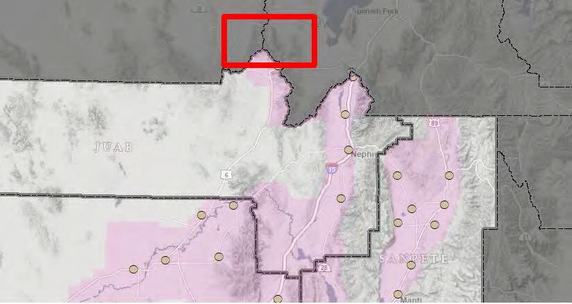
JUAB COUNTY SANPETE COUNTY UTAH COUNTY Nephi Mona Fourmile Creek Gardners Fork 132Highway Draw BiglowsCanyon ColdCanyonValley West Creek ValleyLittle BiglowsCanyon Highway 41 Big Hollow SouthSpringCanyon BurristonPondsTributary CreekBirchLittle CedarPoint North Canyon Quaking Aspen Canyon Juab Highschool Draw CanyonAspenQuaking Silver Creek Salt Creek West Creek Springs Nephi Airport Cedar Ridge Valley I-32WaterHollow BroadCanyon Gardner Creek Cazier Canyon Lower Water Hollow Burriston Ponds Biglows Canyon Tributary Right Fork Old Canyon Miller Canyon Spring Canyon Birch Creek Government Canyon Currant Creek Old Canyon Valley Long Ridge WillowCreek LongRidgeSouthBranch Serviceberry Hollow Water Hollow Salt Creek Draft Zone A Base Level Engineering (BLE) Results Utah Division of Emergency Management NATIONAL FLOOD INSURANCE PROGRAM GREATER SEVIER PROJECT AREA GARFIELD, JUAB, KANE, MILLARD, PIUTE, SANPETE, AND SEVIER COUNTIES, UTAH RISK MAP PROJECT RELEASE DATE 9/22/2023 BLE HYDRAULICS WORK MAP Nevada Colorado Wyoming Arizona TOOELE SAN JUAN MILLARD KANE JUAB IRON EMERY UINTAH BOX ELDER GARFIELD GRAND UTAH WAYNE BEAVER SEVIER SUMMIT WASHINGTON CARBON DAVIS DUCHESNE RICH SANPETE CACHE PIUTE WASATCH WEBER SALT LAKE DAGGETT MORGAN STUDY LOCATOR JUAB JUAB SANPETE MILLARD Mona Wales Manti Delta Levan Nephi Scipio Moroni Eureka Lynndyl Ephraim Hinckley Fairview Santaquin Leamington Rocky Ridge Spring City Fountain Green 2 4 1 7 3 5 8 6 9 11 10 12 13 14 15 16 17 18 19 UTAH TOOELE EMERY CARBON WASATCH COUNTY MAP LOCATOR All base information on this map sourced from public data, including the Utah Geospatial Resource Center (UGRC), FEMA, ESRI, and USGS. Note: This map is not an official Flood Insurance Rate Map and the data presented on this map is for draft information only, to be used as best available data where applicable. ***Draft 2023 hydraulic analysis using new LiDAR topography (no ground survey conducted, Tribal Lands excluded). Floodplain delineations are draft and subject to change. * Streams with a drainage area greater than 1 square mile NOTES TO USERS 0 690,000 1,380,000 345,000 Feet I MAP SYMBOLOGY Draft BLE Zone A*** LiDAR Acquisition Area (2014-2019)Project Area Municipalities Counties Alluvial Fan Study Streams* ! A Letters of Map Amendment (LOMA) ! Stream Gauges DRAFT BLM and Other Federal Land State Land National Park Service Private Tribal US Forest Service Land Ownership No Color Effective NFIP Floodplains Effective Zone AE (1%-annual-chance flood) Effective Zone A (1%-annual-chance flood) Effective Floodway (1%-annual-chance flood) Effective Zone AO (1%-annual-chance flood) !!!!!!! Effective 0.2%-annual-chance flood Proposed Detailed Study Area (TBD) Study Streams Outside Initial Refinement Area** ** Floodplain cleanup and refinement within unincorporated areas to occur after Discovery. These areas mainly constitute state and federal land ownership. Juab and Sanpete County - Unincorporated Areas 5 Map


MILLARD COUNTY JUAB COUNTY Leamington Wild Horse Peak Short Trail Creek SevierRiver NorthGilsonWash Middle ForkSage Valley Spring Canyon Wash RiverSevier South Little Sage Valley Middle Fork Sage Valley Trib McintyreDraw South Little Sage Valley Trib West Fork Sage Valley West Fork Sage Valley Tributary EastForkSage BranchValleyWest Trib LeamingtonDraw McintyreWash LittleWringerDraw Upper Little SageTributaryValley WringerCanyon Union Wash UnionDraw WoodCanyon CanyonMountainValleyDraw Gilson Wash DrawUisco Dog TributaryWashValley NorthCanyon MountainValleyDraw Little Sage Valley TankCanyon Wild Horse Peak EastForkSageValley Boweler Draw Middle Fork Sage Valley Sevier River Little Sage Valley Mack Draw Lower Little SageTributaryValley CanyonMountainDraw Long Trail Creek EastFork SageValley WestBranch LeamingtonWash UpperEastForkSageValley DogValleyWash WildHorsePeak Draft Zone A Base Level Engineering (BLE) Results Utah Division of Emergency Management NATIONAL FLOOD INSURANCE PROGRAM GREATER SEVIER PROJECT AREA GARFIELD, JUAB, KANE, MILLARD, PIUTE, SANPETE, AND SEVIER COUNTIES, UTAH RISK MAP PROJECT RELEASE DATE 9/22/2023 BLE HYDRAULICS WORK MAP Nevada Colorado Wyoming Arizona TOOELE SAN JUAN MILLARD KANE JUAB IRON EMERY UINTAH BOX ELDER GARFIELD GRAND UTAH WAYNE BEAVER SEVIER SUMMIT WASHINGTON CARBON DAVIS DUCHESNE RICH SANPETE CACHE PIUTE WASATCH WEBER SALT LAKE DAGGETT MORGAN STUDY LOCATOR JUAB JUAB SANPETE MILLARD Mona Wales Manti Delta Levan Nephi Scipio Moroni Eureka Lynndyl Ephraim Hinckley Fairview Santaquin Leamington Rocky Ridge Spring City Fountain Green 2 4 1 7 3 5 8 6 9 11 10 12 13 14 15 16 17 18 19 UTAH TOOELE EMERY CARBON WASATCH COUNTY MAP LOCATOR All base information on this map sourced from public data, including the Utah Geospatial Resource Center (UGRC), FEMA, ESRI, and USGS. Note: This map is not an official Flood Insurance Rate Map and the data presented on this map is for draft information only, to be used as best available data where applicable. ***Draft 2023 hydraulic analysis using new LiDAR topography (no ground survey conducted, Tribal Lands excluded). Floodplain delineations are draft and subject to change. * Streams with a drainage area greater than 1 square mile NOTES TO USERS 0 690,000 1,380,000 345,000 Feet I MAP SYMBOLOGY Draft BLE Zone A*** LiDAR Acquisition Area (2014-2019)Project Area Municipalities Counties Alluvial Fan Study Streams* ! A Letters of Map Amendment (LOMA) ! Stream Gauges DRAFT BLM and Other Federal Land State Land National Park Service Private Tribal US Forest Service Land Ownership No Color Effective NFIP Floodplains Effective Zone AE (1%-annual-chance flood) Effective Zone A (1%-annual-chance flood) Effective Floodway (1%-annual-chance flood) Effective Zone AO (1%-annual-chance flood) !!!!!!! Effective 0.2%-annual-chance flood Proposed Detailed Study Area (TBD) Study Streams Outside Initial Refinement Area** ** Floodplain cleanup and refinement within unincorporated areas to occur after Discovery. These areas mainly constitute state and federal land ownership. Juab and Millard County - Unincorporated Areas 7 Map

! A ! A!A ! A ! A ! A ! A ! A ! A ! A ! A JUAB COUNTY SANPETE COUNTY Fountain Green Levan Cedar Point North Wide Canyon SageValley PassNorth Branch NorthLevan Ridge Tributary Pole Canyon Birch Creek Gardners Fork HartleysCanyon Suttons Canyon NorthLevanRidge PigeonCreek ChickenCreek Tidds Canyon Wood Hollow Tributary HollowServiceberry HillsNorthWest Wash HartleysCanyon NorthBranch TributaryDevilsGate Basin Canyon Creek Prospects Mine WoodHollowTributary OldPinery Springs Silver Creek SpringHollow West Hills South Branch Pigeon Creek Tributary Holman CanyonHollow GammettCreek Jerusalem Wash Devils Gate Creek WestHills RockHollow IndianHollow SouthGardnersFork Branch Harleys Canyon South Sage Valley DistributaryPass SaltLakeMeridianDraw PassSageValley BranchSouth LampsonCanyon EastChickenSlough LevanDraw LevanRidgeDraw Maple Canyon Deep Creek Old Pinery Canyon Sage Valley Pass FourmileCreek SnowSpring Big Hollow FountainGreenCreek Draft Zone A Base Level Engineering (BLE) Results Utah Division of Emergency Management NATIONAL FLOOD INSURANCE PROGRAM GREATER SEVIER PROJECT AREA GARFIELD, JUAB, KANE, MILLARD, PIUTE, SANPETE, AND SEVIER COUNTIES, UTAH RISK MAP PROJECT RELEASE DATE 9/22/2023 BLE HYDRAULICS WORK MAP Nevada Colorado Wyoming Arizona TOOELE SAN JUAN MILLARD KANE JUAB IRON EMERY UINTAH BOX ELDER GARFIELD GRAND UTAH WAYNE BEAVER SEVIER SUMMIT WASHINGTON CARBON DAVIS DUCHESNE RICH SANPETE CACHE PIUTE WASATCH WEBER SALT LAKE DAGGETT MORGAN STUDY LOCATOR JUAB JUAB SANPETE MILLARD Mona Wales Manti Delta Levan Nephi Scipio Moroni Eureka Lynndyl Ephraim Hinckley Fairview Santaquin Leamington Rocky Ridge Spring City Fountain Green 2 4 1 7 3 5 8 6 9 11 10 12 13 14 15 16 17 18 19 UTAH TOOELE EMERY CARBON WASATCH COUNTY MAP LOCATOR All base information on this map sourced from public data, including the Utah Geospatial Resource Center (UGRC), FEMA, ESRI, and USGS. Note: This map is not an official Flood Insurance Rate Map and the data presented on this map is for draft information only, to be used as best available data where applicable. ***Draft 2023 hydraulic analysis using new LiDAR topography (no ground survey conducted, Tribal Lands excluded). Floodplain delineations are draft and subject to change. * Streams with a drainage area greater than 1 square mile NOTES TO USERS 0 690,000 1,380,000 345,000 Feet I MAP SYMBOLOGY Draft BLE Zone A*** LiDAR Acquisition Area (2014-2019)Project Area Municipalities Counties Alluvial Fan Study Streams* ! A Letters of Map Amendment (LOMA) ! Stream Gauges DRAFT BLM and Other Federal Land State Land National Park Service Private Tribal US Forest Service Land Ownership No Color Effective NFIP Floodplains Effective Zone AE (1%-annual-chance flood) Effective Zone A (1%-annual-chance flood) Effective Floodway (1%-annual-chance flood) Effective Zone AO (1%-annual-chance flood) !!!!!!! Effective 0.2%-annual-chance flood Proposed Detailed Study Area (TBD) Study Streams Outside Initial Refinement Area** ** Floodplain cleanup and refinement within unincorporated areas to occur after Discovery. These areas mainly constitute state and federal land ownership. Juab and Sanpete County - Unincorporated Areas 8 Map


MILLARD COUNTY JUAB COUNTY CowCanyon The Cove Skinner Wash WringerCanyonTributary Wide Canon Tributary 2 Wide TributaryCanon 1 Little OakCreek Low Hills NorthWringer CanyonTributary Veterans Memorial Highway Sevier River WildHorsePeak Wide CanyonValley TrailTrib Union Draw ShallowDraw Yuba Wash MiddleDraw WestSlopeDraw Middle Fork Sage Valley Lower Cow Canyon VeteransMemorialHighway SevierRiver WideCanyon Spring Distributary Ditch Draw Skinner Wash Flat Wash LowerDitchDraw Wide Canyon Valley Trail Chicken Creek Trail Wash CanyonLowerCow BranchNorth Wringer Canyon LowerCow CanyonSouth Branch WideCanyonValley Wild Horse Peak South Hills Flat Canyon CowCanyon ChrissCreek WideCanyon Wide Canyon Spring Draft Zone A Base Level Engineering (BLE) Results Utah Division of Emergency Management NATIONAL FLOOD INSURANCE PROGRAM GREATER SEVIER PROJECT AREA GARFIELD, JUAB, KANE, MILLARD, PIUTE, SANPETE, AND SEVIER COUNTIES, UTAH RISK MAP PROJECT RELEASE DATE 9/22/2023 BLE HYDRAULICS WORK MAP Nevada Colorado Wyoming Arizona TOOELE SAN JUAN MILLARD KANE JUAB IRON EMERY UINTAH BOX ELDER GARFIELD GRAND UTAH WAYNE BEAVER SEVIER SUMMIT WASHINGTON CARBON DAVIS DUCHESNE RICH SANPETE CACHE PIUTE WASATCH WEBER SALT LAKE DAGGETT MORGAN STUDY LOCATOR JUAB JUAB SANPETE MILLARD Mona Wales Manti Delta Levan Nephi Scipio Moroni Eureka Lynndyl Ephraim Hinckley Fairview Santaquin Leamington Rocky Ridge Spring City Fountain Green 2 4 1 7 3 5 8 6 9 11 10 12 13 14 15 16 17 18 19 UTAH TOOELE EMERY CARBON WASATCH COUNTY MAP LOCATOR All base information on this map sourced from public data, including the Utah Geospatial Resource Center (UGRC), FEMA, ESRI, and USGS. Note: This map is not an official Flood Insurance Rate Map and the data presented on this map is for draft information only, to be used as best available data where applicable. ***Draft 2023 hydraulic analysis using new LiDAR topography (no ground survey conducted, Tribal Lands excluded). Floodplain delineations are draft and subject to change. * Streams with a drainage area greater than 1 square mile NOTES TO USERS 0 690,000 1,380,000 345,000 Feet I MAP SYMBOLOGY Draft BLE Zone A*** LiDAR Acquisition Area (2014-2019)Project Area Municipalities Counties Alluvial Fan Study Streams* ! A Letters of Map Amendment (LOMA) ! Stream Gauges DRAFT BLM and Other Federal Land State Land National Park Service Private Tribal US Forest Service Land Ownership No Color Effective NFIP Floodplains Effective Zone AE (1%-annual-chance flood) Effective Zone A (1%-annual-chance flood) Effective Floodway (1%-annual-chance flood) Effective Zone AO (1%-annual-chance flood) !!!!!!! Effective 0.2%-annual-chance flood Proposed Detailed Study Area (TBD) Study Streams Outside Initial Refinement Area** ** Floodplain cleanup and refinement within unincorporated areas to occur after Discovery. These areas mainly constitute state and federal land ownership. Juab and Millard County - Unincorporated Areas 12 Map


! A ! A ! A JUAB COUNTY SANPETE COUNTY Wales Pigeon Creek San Pitch River LittleSalt GravelPit OakCreek Spring Hollow GravelWash Spring Hollow South Branch Tributary ProspectorDraw SpringHollow Bugle Hollow CreekSaltLittle Rock Canyon Creek Dry Canyon Creek PetesCanyon CreekTributary TributaryHollowBugle Skinner Wash South LittleSaltCreek DeepCreek SouthSpringHollow Branch CoalCanyon Draw Botham Wash PigeonCreek Spring Hollow Gravel Pit Draw MapleCreek Petes Canyon Creek EphraimCreekLower Maple Creek Tributary HorseMountainDraw Chicken Creek East Chicken Slough Coal Canyon Creek Big Mountain Draw AxhandleCanyonCreek ChrissCreek SpringQuarryDraw EphraimCreek Little Salt South Hill Deep Creek Chriss Canyon Spring Wales Canyon Creek Skinner Wash SkinnerPeaks FlatCanyon Creek Draft Zone A Base Level Engineering (BLE) Results Utah Division of Emergency Management NATIONAL FLOOD INSURANCE PROGRAM GREATER SEVIER PROJECT AREA GARFIELD, JUAB, KANE, MILLARD, PIUTE, SANPETE, AND SEVIER COUNTIES, UTAH RISK MAP PROJECT RELEASE DATE 9/22/2023 BLE HYDRAULICS WORK MAP Nevada Colorado Wyoming Arizona TOOELE SAN JUAN MILLARD KANE JUAB IRON EMERY UINTAH BOX ELDER GARFIELD GRAND UTAH WAYNE BEAVER SEVIER SUMMIT WASHINGTON CARBON DAVIS DUCHESNE RICH SANPETE CACHE PIUTE WASATCH WEBER SALT LAKE DAGGETT MORGAN STUDY LOCATOR JUAB JUAB SANPETE MILLARD Mona Wales Manti Delta Levan Nephi Scipio Moroni Eureka Lynndyl Ephraim Hinckley Fairview Santaquin Leamington Rocky Ridge Spring City Fountain Green 2 4 1 7 3 5 8 6 9 11 10 12 13 14 15 16 17 18 19 UTAH TOOELE EMERY CARBON WASATCH COUNTY MAP LOCATOR All base information on this map sourced from public data, including the Utah Geospatial Resource Center (UGRC), FEMA, ESRI, and USGS. Note: This map is not an official Flood Insurance Rate Map and the data presented on this map is for draft information only, to be used as best available data where applicable. ***Draft 2023 hydraulic analysis using new LiDAR topography (no ground survey conducted, Tribal Lands excluded). Floodplain delineations are draft and subject to change. * Streams with a drainage area greater than 1 square mile NOTES TO USERS 0 690,000 1,380,000 345,000 Feet I MAP SYMBOLOGY Draft BLE Zone A*** LiDAR Acquisition Area (2014-2019)Project Area Municipalities Counties Alluvial Fan Study Streams* ! A Letters of Map Amendment (LOMA) ! Stream Gauges DRAFT BLM and Other Federal Land State Land National Park Service Private Tribal US Forest Service Land Ownership No Color Effective NFIP Floodplains Effective Zone AE (1%-annual-chance flood) Effective Zone A (1%-annual-chance flood) Effective Floodway (1%-annual-chance flood) Effective Zone AO (1%-annual-chance flood) !!!!!!! Effective 0.2%-annual-chance flood Proposed Detailed Study Area (TBD) Study Streams Outside Initial Refinement Area** ** Floodplain cleanup and refinement within unincorporated areas to occur after Discovery. These areas mainly constitute state and federal land ownership. Juab and Sanpete County - Unincorporated Areas 13 Map

MILLARD COUNTY JUAB COUNTY SANPETE COUNTY Scipio Hardscrabble Canyon Low Hills Windmill Tributary Painted RockCanyon WashTrib2 PaintedRightFork RockCanyonWash CanyonLowrys Hardscrabble Canyon Tributary DoverDraw The TributaryCove SevierRiver Little Oak Creek Chriss Hollow Low Hills Hardscrabble CanyonNorth Branch Little Oak Creek South Branch PaintedRock CanyonWash Little Oak CreekBranchNorth Low Hills Trail Draw Faye Draw Red Canyon The Cove Yuba Wash Dick and Dalton Draw TriCountyWash Draft Zone A Base Level Engineering (BLE) Results Utah Division of Emergency Management NATIONAL FLOOD INSURANCE PROGRAM GREATER SEVIER PROJECT AREA GARFIELD, JUAB, KANE, MILLARD, PIUTE, SANPETE, AND SEVIER COUNTIES, UTAH RISK MAP PROJECT RELEASE DATE 9/22/2023 BLE HYDRAULICS WORK MAP Nevada Colorado Wyoming Arizona TOOELE SAN JUAN MILLARD KANE JUAB IRON EMERY UINTAH BOX ELDER GARFIELD GRAND UTAH WAYNE BEAVER SEVIER SUMMIT WASHINGTON CARBON DAVIS DUCHESNE RICH SANPETE CACHE PIUTE WASATCH WEBER SALT LAKE DAGGETT MORGAN STUDY LOCATOR JUAB JUAB SANPETE MILLARD Mona Wales Manti Delta Levan Nephi Scipio Moroni Eureka Lynndyl Ephraim Hinckley Fairview Santaquin Leamington Rocky Ridge Spring City Fountain Green 2 4 1 7 3 5 8 6 9 11 10 12 13 14 15 16 17 18 19 UTAH TOOELE EMERY CARBON WASATCH COUNTY MAP LOCATOR All base information on this map sourced from public data, including the Utah Geospatial Resource Center (UGRC), FEMA, ESRI, and USGS. Note: This map is not an official Flood Insurance Rate Map and the data presented on this map is for draft information only, to be used as best available data where applicable. ***Draft 2023 hydraulic analysis using new LiDAR topography (no ground survey conducted, Tribal Lands excluded). Floodplain delineations are draft and subject to change. * Streams with a drainage area greater than 1 square mile NOTES TO USERS 0 690,000 1,380,000 345,000 Feet I MAP SYMBOLOGY Draft BLE Zone A*** LiDAR Acquisition Area (2014-2019)Project Area Municipalities Counties Alluvial Fan Study Streams* ! A Letters of Map Amendment (LOMA) ! Stream Gauges DRAFT BLM and Other Federal Land State Land National Park Service Private Tribal US Forest Service Land Ownership No Color Effective NFIP Floodplains Effective Zone AE (1%-annual-chance flood) Effective Zone A (1%-annual-chance flood) Effective Floodway (1%-annual-chance flood) Effective Zone AO (1%-annual-chance flood) !!!!!!! Effective 0.2%-annual-chance flood Proposed Detailed Study Area (TBD) Study Streams Outside Initial Refinement Area** ** Floodplain cleanup and refinement within unincorporated areas to occur after Discovery. These areas mainly constitute state and federal land ownership. Millard and Sanpete County - Unincorporated Areas 17 Map