A Report on the Role of Design Thinking in Zoning Reform
January 2025
Tim Love
Amy Dain
Sam Naylor
Camille Wimpe
The authors would like to thank the many planners, planning board chairs, public officials, advocates, and experts who have shared their time, attention, insights, and ideas to contribute to this report. We would also like to thank the members of planning boards and other zoning committees in Framingham, Ipswich, and Canton for listening to our ideas and offering feedback. We are grateful to the staff in the Provost’s Office and the Dean’s Office in the College of Arts, Media and Design at Northeastern University for advising us and supporting this project, including Liz Allen, Amy Carroll, Wendy Friedman, and Olivia Saucier. We are also thankful to Kelly Kramer for copyediting the final report. Finally, we would like to thank the students from Tim Love’s Spring 2024 Northeastern University design studio, “MBTA Communities Housing Law: Designing Zoning for Intentional Urban Design Outcomes” (ARCH 5115), for sharing their original ideas about zoning with us. Those are Lee Anderson, William Blanchette, Celita Cadet, Xuanzhi Chen, Michael Collazo, George Danison, Gabrielle Danitz, Evan Diaz, Lucas Di Cugno, Eleanor Garner, Kiet Ho, Etan Khlevnoy, and Kaman Leung.
Support and Advice From
Andrea Bates, Josh Fiala, Chris Herbert, Tom Hopper, Kristina Johnson, Chris Kluchman, Patricia McDermott, Sarkis Sarkisian, and TJ Torres.
Funded by Northeastern University’s Impact Engine Grant
Impact Engines galvanize and organize interdisciplinary learning, research, and partnerships around solving a challenge or set of challenges, with the goal of maximum impact. Impact Engines span disciplines, colleges, campuses, and industry sectors, connecting diverse communities of problem-solvers around creating measurable change. They are a key pillar of the university’s new academic plan and a means for Northeastern to claim leadership as an institution with a broad societal impact. impactengines.northeastern.edu
Tim Love, FAIA Director of Research
Tim Love is the founding principal of Utile and leads the firm’s urban design and planning practice. He is also a tenured associate professor at Northeastern University’s School of Architecture, where he teaches design studios and seminars that focus on the intersection of urban design, policy, and real estate development. Love’s expertise ranges from innovative zoning approaches and a comprehensive understanding of market-driven building types to the strategic layout of streets, blocks, and parcels and the design of Complete Streets and the larger public realm. Love’s clients include municipalities, state authorities and agencies, and national developers. In addition to his academic position at Northeastern, Love is a lecturer in real estate at the Harvard Graduate School of Design and has taught at Yale and the University of Toronto. He was also the 2014 president of the Boston Society of Architects and currently serves on the Dean’s Advisory Board at the University of Virginia School of Architecture.
Amy Dain Project Manager
Amy Dain is an independent consultant in public policy research and writing. She focuses on urban and suburban planning, housing policy, and zoning and frequently presents at conferences and events.
Her career has been a tour of Massachusettsbased think tanks. She has worked in-house or as a consultant on projects for Collins Center for Public Management, Pioneer Institute for Public Policy Research, Rappaport Institute for Greater Boston, MassINC, Lincoln Institute of Land Policy, Massachusetts Smart Growth Alliance, Jewish Community Relations Council of Greater Boston, and other organizations.
Sam Naylor, AIA Lead Designer
Sam Naylor is an architect, educator, and researcher of housing in the US. Currently, he is an associate at Utile, where he focuses on multifamily housing in and around New England. Recently, he completed the Harvard Druker Traveling Fellowship, where he investigated cooperative housing design around the world; in parallel, he has been putting theory into practice by decarbonizing and renovating a cooperatively owned triple-decker with friends in Jamaica Plain. He is an author of the recently released report “Legalizing Mid-Rise Single-Stair Housing in Massachusetts,” as well as a co-editor of The State of Housing Design 2023, a book about national design trends—both published by The Harvard Joint Center for Housing Studies. He believes everyone has a right to a dignified, affordable, and delightful dwelling and is in pursuit of more expansive and imaginative designs for housing—from the block to the bedroom.
Camille Wimpe Research Assistant
Camille Wimpe is pursuing a master’s degree in architecture at Northeastern University, where she recently received a B.S. in architecture. She has worked at multiple design firms in Boston, with a particular focus on housing projects at multiple scales. She has worked as a teaching assistant in several undergraduate-level studios and history courses. Her research interests include the de-commodification of housing and land, as well as the impact of policy and economics on the urban realm.
Introduction
For more than a century, Massachusetts municipalities have used zoning to influence neighborhood aesthetics, among many other things. Zoning reformers have adopted maps, dimensional standards, use requirements, diagrams, design guidelines, and discretionary permit approval processes to improve the design of buildings and districts, especially as experienced from the public realm of streets and sidewalks, as well as from neighboring properties. However, zoning has had a poor record of success with design, especially for multifamily housing development. Zoning has over-restricted multifamily housing and sent it to the edges of municipalities and regions. Zoning has predominantly favored car access above other
design purposes. On net, zoning has been a drag on development of vibrant, walkable, fine-grained, mixed-use districts.
Over the decades, reformers have tried different approaches to remedy the shortcomings of conventional zoning with regard to design. The original zoning codes included transparent district designations and straightforward dimensional standards, such as minimum lot sizes, maximum building heights, and minimum setbacks of buildings from property lines. Transparency is critical, but the blunt tools were wielded to limit development and protect singlefamily districts from all other uses, more than to shape it. The remedies to original zoning’s shortcomings have included A) discretionary
decision-making for permit approvals, B) design guidelines, C) mixed-use zoning requirements, and D) form-based zoning.
The remedies all represent important and potentially useful tools in the zoning toolkit. They can all be effective, when implemented well. The remedies have had their own shortcomings, though. The toolkit has proven insufficient, and the politics have not favored wise use of the zoning tools. In particular, there has been a hole in the toolkit for allowing small- and mediumscale infill multifamily housing to be built predictably and transparently in existing neighborhoods and centers.
Discretionary decision-making has added cost and time to residential
development and is too often used to downsize or block projects, instead of to leverage projects for public benefit. Design guidelines are often aspirational but difficult to enforce, or they can be the basis for long public discussion and delay. Design guidelines can cause unwarranted cost escalations. Mixed-use requirements, which some municipalities have used to mandate first-floor commercial space in all new multifamily projects, can be a barrier to building, or a cost driver, where the market for commercial space is weak. Form-based zoning is sometimes too complicated for property owners and public officials to use with ease.
This report presents a set of easyto-understand zoning tools that may have a better success rate at improving the design of multifamily housing development, while making room for more housing than current regulations do. The tools can be called “design-based” or “form-based lite.” They constitute a streamlined version of formbased codes. The tools presented here are specifically geared for regulating, and encouraging, smalland medium-scale infill multifamily housing development in existing walkable, transit-connected, mixeduse neighborhoods. The report’s reforms thus support “gentle density,” also called “the missing middle” of housing options that come between single-family-home development and big multifamily
projects. The big-picture policy aim is to move beyond car-dominant, highway-oriented development toward growth patterns that bolster multimodal transportation choices—and to make room for more people to live in nice places.
The first step toward achieving good design is figuring out where multifamily housing belongs. For decades, Greater Boston has been prioritizing, or defaulting to, municipal edges, especially parcels hidden between highways and waterways, for apartments and condos. These areas have been somewhat disconnected from Greater Boston’s beloved traditional walkable neighborhoods. This report makes recommendations for allowing multifamily housing in areas that are, or could be, amenityrich, transit-served, and walkable.
The second step of regulating for good design involves establishing standards for building form and placement. The “design-based” zoning tools presented in this report are measurable, nondiscretionary standards that can be included in zoning reforms that allow multifamily housing as of right (meaning without the need for discretionary approvals). The tools include
• maximum building footprints,
• maximum number of stories and the half-story,
• facade build-out ratio,
• maximum facade length,
• minimum usable open space,
• parking standards, and
• frontage-zone requirements.
Finally, the report also presents a methodology for designing locally tailored regulations.
This report is not meant as the final word on design regulations but as an opening conversation, to spark new thinking on a tough issue. Other standards could be added to this list of tools.
One other takeaway of this initiative is that it can be helpful to involve architects in the development and promotion of new zoning codes.
Audience for the Report Regulation versus Production of Good Design
This report is about public regulation of private residential development; the primary audience for the report is zoning policymakers, which can include municipal planning board members, city councillors, town meeting members, housing advocates and activists, regional and municipal planners, state legislators, planning consultants, and many others. The secondary audience includes those who interact with zoning laws, such as architects, developers, and property owners.
Since zoning has been implemented primarily at the municipal level, most of the report addresses municipal authorities as primary decisionmakers. However, the authority to zone comes from state power; Massachusetts delegates authority to its municipalities. The state can, and should, play a larger role in planning and zoning for multifamily housing in walkable, transitconnected, mixed-use areas, so these tools should be of interest to both municipal and state leaders.
The report looks at zoning policy in Boston’s suburbs as a case study, but the findings should be relevant to zoning reform efforts across the country. Greater Boston boasts hundreds of traditional walkable connected centers that could benefit from the zoning tools proposed in this report.
This report is not a presentation of best practices in residential design generally. The report specifically addresses regulatory tools that governments can use to influence design. These tools are necessarily limited. Ultimately, good design relies on the training, tastes, priorities, and benevolence of architects, property owners, developers, engineers, and contractors, as well as on
the preferences of buyers. Costs of materials and labor influence design outcomes, too. Building codes, both well-conceived and misguided ones, also substantially impact design outcomes. Zoning regulations set parameters, but they are not the same thing as architectural and site plans for properties and neighborhoods. The best zoning rules may prevent the worst design outcomes, but they
may simultaneously prevent some superior designs. It is difficult to balance predictability and clarity of rules with flexibility for designers to create unique solutions for complicated challenges, although this report does aim to bring a balance into view.
Underlying the report’s recommendations, there are assumptions about good design for new building added to walkable, historic neighborhoods:
• Most historic centers boast fine-grained urbanism, meaning there are many varied buildings, entrances, walkways, windows, trees, plants—frequent changes in texture and use of structures and land—to be seen by pedestrians walking the length of sidewalk. Buildings can be short or towering, but they are not monolithic; districts are not characterized by blocklength walls, one after another. Buildings that fit into the patterns of fine-grained urbanism will generally not detract from the existing design.
• For historic centers, variation in style and form of architecture, including roofs and balconies, is generally a positive feature, superior to a monoculture of plain-box buildings, although plain boxes fit into the diversity.
• The layout of whole neighborhoods is more important than the design of individual
buildings. Capacious, continuous sidewalks, street trees, and bus shelters, for example, can add more to the pedestrian experience of a Main Street than the aesthetics of any given building facade.
• The addition of housing to historic centers is important not only for the new residents of the housing, but also to bolster the vitality of neighborhoods, the viability of shops and mass transit, and the social capital of places. In this way, density of housing improves the viability of good district-level design.
• Diverse setups for private open space, including balconies, porches, patios, lawns, stoops, gardens, walkways, etc., generally enhance the look and function of a neighborhood.
• The accommodation of parking for new housing development is one of the greatest challenges of urban design today. Parking lots are not attractive features, and structured parking makes for bulky buildings. Underground parking is better for design but is often prohibitively expensive. Car access often interrupts pedestrian walkways. In general, it is very difficult to optimize layout for both cars and pedestrians. From a design perspective, it is better for municipalities to manage off-site parking, such as on the street and in public lots or garages,
than to require onsite parking for every property. The excellent neighborhood layouts of historic centers were designed before cars dominated mobility; modern development can follow the historic patterns, if parking is managed well at the district level.
About the Research
This report is a project of Northeastern University’s Impact Engine program, which supports interdisciplinary research and collaboration to address real-world problems. Members of the research team have been thinking about and working on issues of residential design, zoning regulation, and municipal land use planning in different ways, with different expertise, and with different clients and employers. The research team came together to combine their skillsets, share their past work, and study the zoning of three municipalities, as case studies, to make recommendations for best practices in zoning for improved design of multifamily residential buildings.
The three municipalities used as case studies were Canton, Framingham, and Ipswich. Each municipality has been under a new state mandate to reform its zoning to allow more multifamily housing, as of right, near its train stations. The state law, called MBTA Communities zoning law, adopted in 2021, requires cities and towns served by the MBTA (regional transit authority) to zone for multifamily housing near transit stations. The research study was designed not only to yield generalized recommendations for zoning reformers in any community with a historic, walkable, transitserved center, but also to make implementable recommendations directly to specific communities
grappling with zoning reform right now. Canton adopted new multifamily zoning at the end of the engagement process but did not integrate recommendations from this research project into its zoning. Ipswich and Framingham have not yet (as of December 2024) adopted multifamily zoning to comply with the MBTA Communities zoning law.
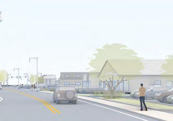
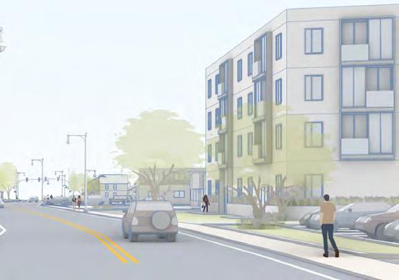
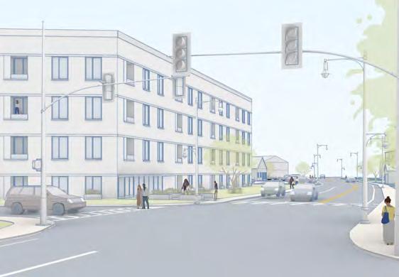
In studying the zoning for three municipalities, the team sketched visuals of potential development of sample properties under current zoning and under different potential zoning reforms that would be consistent with the MBTA Communities zoning law and the state’s implementation guidelines for the law. The team visited Canton, Framingham, and Ipswich and met with their municipal planners and other public officials. The research team acted as advisors, offering suggestions and responding to the clients’ feedback about preferences for locations of zoning districts and specifics of zoning requirements. The research team attended, via Zoom, meetings of planning boards for all three municipalities, hearing input from the board, gleaning insights from public hearings, and presenting draft visuals that the team created, along with recommendations.
Many of these visuals are presented in this report. The research team based its finding for this report not only on lessons learned from the three case studies, but also
on insights and experiences from their work with other municipalities, as well as literature reviews and other research conducted by team members.
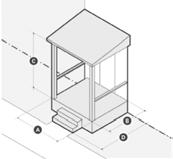
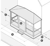
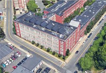
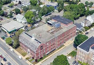
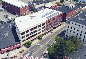
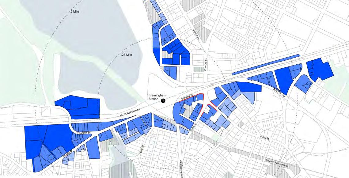
A map illustrating the location of the municipalities the research team worked with
Ipswich
Framingham
Canton
History of Zoning for Design
Good design of neighborhoods and districts has always been a goal of zoning, which got its start, in Massachusetts, in the 1920s. In 1921, planning consultants made a pitch for zoning adoption in The Boston Globe, arguing that zoning will “protect eyes from offensive sights.”1 The idea of zoning was not only to keep ugly, noxious factories away from residential districts, but also to keep homes far enough apart from each other and from the street to create a park-like setting for residences. From the beginning, zoning set aside the larger parts of municipalities for single-family housing only; it highly restricted multifamily development with basic restrictions on height and setbacks and requirements for minimum parcel sizes and minimum land area per dwelling unit. Zoning was the code for sprawl development, suited for auto-mobility.
A 1921 annual report of Somerville’s planning board explained: “The old motto ‘A place for everything and everything in its place’ should be made to apply to buildings erected within the city limits.”2 This motto underscored the concept of zoning, but zoning never made enough place for multifamily housing. Many critics of zoning for decades have decried zoning’s separation of different uses into different districts, but even more important, zoning simply did not establish enough room for diverse housing types. Zoning has also relegated multifamily housing to
less desirable locations.
Zoning reformers of the early zoning era aimed to craft transparent regulations that would reduce corruption in local government’s management of real estate development. Conventional zoning included maps of districts, tables of allowed uses (such as residences, retail, and factories) for each district, and tables of allowed dimensional requirements for buildings located in each district. Common dimensional requirements included minimum lot sizes, maximum number of dwelling units per acre, maximum height and maximum stories of buildings, minimum frontage (the length of the property line along the public way), and minimum setbacks of buildings from property lines. Conventional zoning also included requirements for onsite parking spaces. Municipal decisions about whether to grant permits for building projects were mostly nondiscretionary; projects that met the measurable requirements would be approved. This became known as as-of-right or by-right permitting. As of right means it is the property owner’s right to build when the requirements are met.
A primary function of original zoning codes was to separate perceived incompatible uses into different geographic areas so that, for example, a homeowner would not end up with a noxious factory as a next-door neighbor. Thus, zoning
codes did not allow factories in residential districts or multifamily housing in single-family-only neighborhoods. Many early zoning codes designated separate districts for each category of use: residential single-family, residential multifamily (often called general residence), commercial, and industrial.
Other early zoning codes created a pyramid of use designations, so that all “less intensive” uses would be allowed within a given district. Under pyramid zoning, nothing is “less intensive” than single-family homes (other than open space), so in single-family districts, only single-family homes would be allowed. In multifamily districts, single-family homes would be allowed. In commercial districts, single-family homes and multifamily homes would be allowed. In industrial districts, all uses would be allowed. So, contrary to some zoning discourse, not all early zoning completely precluded mixes of uses, across all municipalities—except in neighborhoods designated for single-family homes. (Note, though, that this report’s researchers did not survey early zoning codes in Massachusetts to determine the extent of full separation versus pyramid separation. Also note that municipalities cannot zone districts of privately owned unrestricted land for open space only, prohibiting all other uses and all types of buildings. Such blanket prohibitions would be considered an
unconstitutional government taking of property without compensation.)
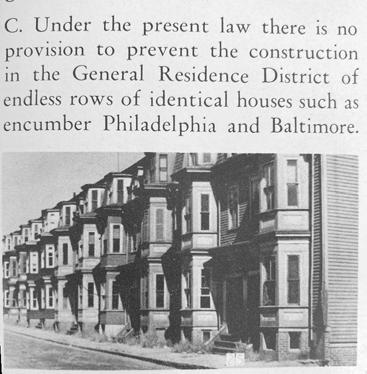
The 1930s and early 1940s did not see as much action in zoning adoption and reform, as the Depression and World War II distracted resources from private real estate development. But attention soon returned to zoning. Arthur and Sidney Shurcliff, leaders in land use planning, explained in Dedham’s 1947 Master Plan that Dedham’s current zoning had no provision to prevent construction in the General Residence District “of endless rows of identical houses such as encumber Philadelphia and Baltimore.”3 They proposed that multifamily dwellings should not exceed three stories and not cover more than 30 percent of the lot, with a front setback of at least 25
feet and a rear setback of 35 feet. These proposed requirements, they argued, would permit the building of “attractive garden-apartmenttype developments favored by real estate and insurance companies.” They concluded: “These garden apartments often make a most attractive appearance and a better neighborhood than closely spaced and cheaply built single-family houses.” (Row houses at the time were considered by planners to be “single-family attached” houses.)
Today the term “garden apartments” is sometimes used to describe townhouses or first-floor nanny flats, but in the postwar era, “garden apartments” was the term used to describe boxshaped apartment buildings, featuring stacked apartments,
often surrounded by parking lots. Row houses or townhouses had gone out of fashion, as they did not offer much room for parking or for the expected suburban airiness between buildings. Some of the people writing the rules in the 1940s and 1950s had gained first impressions of row houses when they were first built, before the street trees grew to make blocks more graceful; their second impression of row houses came during the Depression and World War II, when owners lacked resources for maintenance. Row houses became associated with the congested cities away from which many people with resources were moving. “Garden apartments” were presented as a modern improvement, and the regulations reflected their priority status.
Images from the Town of Dedham’s 1947 Master Plan
Image from a page in Salem’s 1962 Comprehensive Plan
More municipalities in eastern Massachusetts adopted zoning for the first time in the 1950s than in any other decade. Many of the municipalities that had adopted zoning in earlier decades updated their zoning in the 1950s, in response to tremendous growth pressure. Although a few affluent municipalities, such as Weston and Dover, at the time were banning multifamily housing altogether, most zoning ordinances and bylaws included provisions for garden apartments, with ample parking.
At the time, there was a lot of handwringing about the lack of parking in urban areas, including suburban centers; engineers got busy shoehorning in parking lots and garages. The thrust of many zoning regulations was to avoid this issue in new development; there had to be ample onsite parking. It became common to require two parking spaces per dwelling unit in garden apartments. This translated into a lot of pavement, which often looked like gashes, or jarring disruptions to the urban fabric. The solution to a design problem caused a design problem. But also, prohibitions on multifamily housing development in walkable historic centers became part of the parking solution. Sprawl is good for parking but bad for civilization.
Special Permits and Discretionary Decision-Making
Dissatisfaction with large-scale development, both single-family subdivisions and multifamily projects, was widespread. The 1964 Master Plan of Hudson, Massachusetts, for example, explained: “The quantity market [for housing] is a business proposition; it lacks the individuality or the feeling that would go into a place in which the designer intended to live.4 To some extent, it is the job of the Planning Board to protect the future residents by using their legal powers over subdivision […] in an imaginative way, so that attractive rather than merely adequate development results.” The flexibility of special permits was seen as the method for the imaginative involvement of planning boards in development.
By the mid-century era, zoning reformers promoted flexible zoning under the names cluster zoning, planned unit development, and planned residential development, with the idea that regulations would dictate how many dwelling units are allowed on a parcel; the landowner would have flexibility in laying out the site plan, which would then be subject to a discretionary vote of a municipal board tasked with oversight. Discretionary zoning was promoted as a flexible tool for achieving better designs than would result from rigid, one-sizefits-all standards.The flexible zoning provisions generally required applicants to receive special permits. The Town of Weston’s
1965 Master Plan explains the idea of cluster zoning as follows: “The basic objectives of cluster development are to provide a more esthetically-pleasing and economic solution for residential land development.”5 Developers could build a conventional subdivision as of right or apply for a special permit to cluster the houses on part of the parcel and preserve open space on part of it.
In practice, the “flexible” zoning got gummed up with pages of dimensional requirements, and the discretionary processes added cost and time to the development process, without consistent gains in design outcomes, especially for smaller projects. The discretionary processes are time-consuming, risky, and costly for property owners. This category of regulation not only drives up the cost of development and favors largescale development undertaken by large-scale development firms, but it also discourages many property owners from even bothering with multifamily development.
In theory, the negotiated, discretionary approvals would lead to better designs than standardized dimensional standards, but in practice, the approval processes were used to downsize projects more than to improve looks. Special permit review processes were also used to leverage the value created by development to fund infrastructure improvements,
affordable housing set-asides, and other public benefits. The elected or appointed officials sitting on planning boards, boards of appeals, or other bodies often lacked training in design. They were often not well positioned to negotiate projects for design upgrades, or they leveraged their control to achieve arbitrary design goals.
In the early 1970s came the Big Downzone, where most of Boston suburbs tightened their zoning significantly, largely to ban multifamily housing, or to make the regulations so burdensome that hardly any multifamily housing could feasibly be built under the zoning. After the early 1970s pivot, the vast majority of multifamily housing needed discretionary approval, either through rezoning of parcels or with special permits. Municipalities were not zoning whole districts that cross multiple properties for multifamily housing. Planning boards were not rolling up their sleeves and picking sections of the map to allow it. Instead, developers might apply for a special permit to include townhouses in a cluster subdivision, trading density on part of a large parcel for open-space preservation on part. These projects would be scattered. Also, when a school or church or factory or major commercial operation closed, the municipality would consider options for dense zoning on such properties, on a case-by-case basis. The 1970s saw the launch of the era of
housing shortage and home price escalations that far outpace inflation.
At the same time that zoning got tightened, and favored sprawl, a counter movement in the 1970s began to promote dense development in areas already well served by infrastructure. Over the decades, such development has come under different names, such
as smart growth, new urbanism, 15-minute cities, transit-oriented development, walkable urbanism, and compact development. In 1977, the Massachusetts Office of State Planning published a report, “City and Town Centers: A Program for Growth,”6 recommending increased investment and growth in urban areas (including suburban centers), along with protection of open space.
A map of current zoning for multifamily housing (data from MAPC’s Zoning Atlas, as of 2024)
The vast majority of multifamily housing built in Greater Boston in recent decades has been approved through discretionary zoning approval processes, either involving special permits or a rezoning approved by town meeting or city council.
Zoning’s Separation of Uses and Mixed Uses
The issue of so-called mixed-use regulations has animated zoning reformers for decades, at least back to 1961, when Jane Jacobs published her famous The Death and Life of Great American Cities, concluding,
“American downtowns are not declining mysteriously because they are anachronisms, not because their users have been drained away by automobiles. They are being witlessly murdered, in good part by the deliberate policies of sorting out leisure uses from work uses, under the misapprehension that this is orderly city planning…. Residential districts lacking mixture with work do not fare well in cities.”7
The Town of Hudson’s 1978 Downtown Plan played an optimistic riff on Jacobs’s indictment: “With proper planning and civic energy cohesive
downtowns in small cities and towns have been able to withstand the competition of suburban malls and have attracted specialty shops, services and offices, and in some instances a return of housing to the upper floors. This too can happen in Hudson.”8 The authors of that plan were not conceiving of new buildings combining housing and retail as much as conversion of upstairs space in historic brick
buildings to be used as residences, not left vacant or as underused office or storage space.
In the decades that followed, there was a surge of zoning reform for mixed use within buildings. Almost every suburb of Boston, excluding those that most adamantly opposed multifamily development, revised its zoning to allow for mixed-use buildings—first-floor
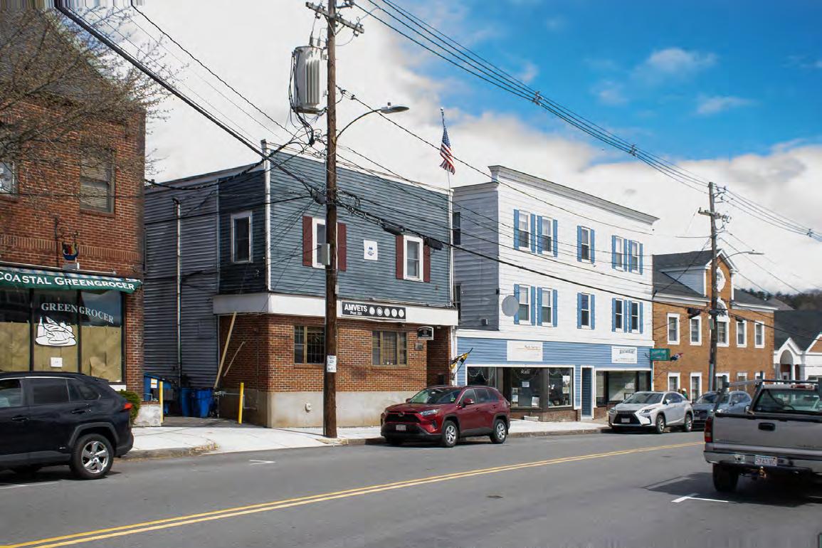
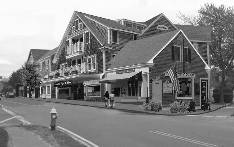
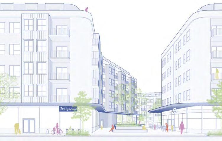
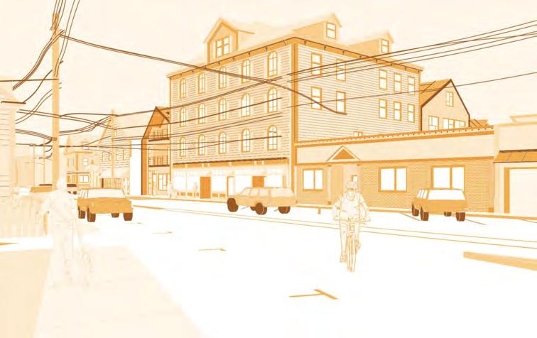
Mixed use in downtown Framingham (image by Lee Anderson)
commercial, below residential. The push for “mixed uses” was not a return to a pre-zoning, market-driven intermingling of uses, and it was not about bringing commercial spaces—or new multifamily housing—to alreadybuilt residential neighborhoods. Mixed-use zoning became a tool for allowing multifamily housing to be developed, only in combination with other uses, in historic commercial hubs, along car-oriented commercial corridors and in redevelopments of industrial and office parks. An unrestrained market would have delivered more single-use residential buildings, and fewer mixed-use buildings, than received permits in the past few decades. The idea of new firstfloor amenities, like restaurants
and cafés, and of commercial tax revenues, motivated local voters to support rezonings for mixeduse buildings. It would have been harder to mobilize voters to support zoning for standalone multifamily residential buildings.
Mixed-use buildings were successfully developed in most of Boston’s suburbs, following the zoning. Many did add welcome amenities to Main Streets and other areas. The new residents supported the retail, and the new retail drew more existing residents to old retail establishments. At the same time, some new retail sat vacant, and some created local surpluses of retail space. Also, where retail revenues are not expected to cover the cost of construction,
the requirement of first-floor retail can add to the cost of residential development, which effectively subsidizes the retail; and the retail requirement can make some projects infeasible.
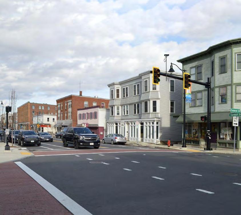
Mixed use in downtown Ipswich (image by Evan Diaz)
Adoption of Design Guidelines
By the 1980s and 1990s, and into the new millennium, some municipalities began adopting design guidelines to educate both property owners and municipal boards about best practices in design, especially for their Main Street corridors. The guidelines have highlighted important design lessons and included useful requirements, as well as some vague language and debatable standards. The guidelines serve to inform project reviews by municipal boards—reviews that can last long and add costs and risk to projects.
Winchester
The Town of Winchester’s Design Review Guidelines state in the zoning bylaw: “The Town seeks new buildings that are timeless and subtle. This will be achieved in part through the design of properly scaled windows, masonry articulation, setbacks, animated silhouettes, and use of materials that are warm, inviting, and supportive of other proposed buildings.”9 Winchester’s guidelines include a lot of general language meant to inspire better design. For example:
“Development in the public and private realms should be integrated in as positive, secure, and elegant a manner as possible. Any part of the perimeter of new development that fronts on an existing street or public open space should be designed to complement and harmonize with adjacent land uses (planned or
existing) with respect to use, scale, density, set-back, bulk, height, landscaping, and screening. Finally, each individual project should be carefully conceived and executed to the mutual benefit of its immediate neighbors.”
Language like this prompts builders and members of special permit-granting authorities to
ask if proposed building designs harmonize with neighboring properties, but of course there will be differences of opinion on such things.
existing cornice line
front wall plane
Visualizing design guidelines in Beverly (image by Google Earth, 2024)
Beverly
Beverly’s 2003 downtown design guidelines include the following recommendations, to be “considered”:
• “Make new construction a product of its own time and not a copy of an older architectural style.
• Maintain the existing front wall plane of the street facade in the design of a new building.
• Maintain the cornice line of existing buildings in the design of new buildings; and consider entire blocks as a single facade— materials, colors, rhythm of elements, and common details should be recognized and incorporated into any new development.
• Newer buildings on the street that contribute little to the architectural character of the street are candidates for new awnings that will establish a more consistent street edge. In this way newer buildings can contribute to the general quality of the street by being unobtrusive background to noteworthy landmark buildings.”10
Watertown
Some design guidelines present ideas that have potential to inspire changes to development plans as they make their way through discretionary approval. For example, Watertown’s design guidelines suggest that:
“Where possible, public art and other cultural considerations should be incorporated into a development. This can range from dedicated community gathering and gallery space, to showcasing local artists’ work in lobbies and other publicly accessible spaces, to exterior pieces of sculpture, murals, and a number of other mediums. This serves to bolster local artists, enrich the public contribution the building makes, better engage the surrounding community, and enhance the passing pedestrian’s experience.”11
Image from Watertown’s design guidelines (by Gamble Associates)
Quincy
Quincy’s guidelines, included in the zoning ordinance, are shorter and relatively straightforward, but still vague in some ways. Quincy’s guidelines are geared specifically to residential structures, while many of the other design guidelines, adopted by other communities, focused on Main Streets.12
“Existing residential structures. All new construction, or construction of any addition where the gross floor area of an existing residential structure is increased by no less than 50%, shall be subject to and in conformance with the following guidelines:
1. The structure shall be oriented to the main street.
2. Primary massing of building should be located along the street facade.
3. The structure shall not have any blank exterior walls.
4. Wherever possible, garage doors shall be oriented away from the main street.
5. Window and door treatments shall be rhythmic in design.
6. Roofs shall not be excessively pitched.
7. Wherever possible, parking areas shall be located to the rear and side of the structure.
8. Parking areas and HVAC equipment shall be appropriately screened.
9. Materials shall be subject to the review of the Director of Inspectional Services and compatible with the general character of the neighborhood and subject to any design guidelines subsequently adopted by the Quincy City Council and approved
by the Mayor, in effect at the time of the filing of an application for a building permit.”
1. structure oriented to the main street / 2. primary massing is along the street
5. windows are rhythmic in design
7. parking is located to the rear of the building
143 Newbury Ave., built in 2019, in relation to Quincy’s design guidelines (image by Google Earth, 2023)
Design guidelines are meant to inform the decisions of planning boards and other deliberative bodies, but the recommendations are open to interpretation. The rights conveyed by by-right zoning trump the aesthetic preferences articulated in design guidelines. However, when permits are discretionary, the permitting board has significant leverage to enforce design guidelines, per its own preferences.
On the other hand, some design guidelines read more as required standards than as vague recommendations. For example, Dennisport’s Village Center Site and Architectural Design Guidelines, adopted in 2005, require that “roof pitch… must be between 6:12 and 12:12, except that
roof pitches towards Route 28 shall be between 8:12 and 12:12.”13
In any case, the critique of design guidelines has been that they can fuel long debates in public meetings, where people without significant design experience add time and cost to housing development. Some design guidelines, meant to correct past egregious architectural errors, lead builders to new ways to build ugly structures. These are anecdotal critiques; a deeper study of the breadth and implementation of design guidelines could shed more light.
Design guidelines are typically paired with design review by the planning board or another municipal board, staffed by the
municipal planning department. In bigger cities, planning staff have capacity to manage the review and make clear recommendations to the decision-makers. Many small towns lack the staff capacity to manage design review effectively; some boards will be better aligned to self-manage the design review than other boards. Without implementation capacity, some design guidelines might just live on the proverbial shelf.
Image included in Dennisport’s design guidelines to demonstrate their effectiveness, compared with existing conditions, at right (images by Offshoots)
Form-Based Codes
Reformers dissatisfied with modern sprawl design and the burdens of discretionary approval processes developed a new approach to zoning known as form-based codes. The idea is to support walkable, transit-oriented, mixeduse development with a new kind of predictable, transparent zoning that allows the densities and uses needed for vibrancy while regulating the shapes of buildings to fit traditional patterns. The national Form-Based Codes Institute, which has merged with Smart Growth America, defines form-based codes like this:
“A form-based code is a land development regulation that fosters predictable built results and high quality public realm by using physical form (rather than separation of uses) as the organizing principle for the code. A form-based code is a regulation, not a mere guideline, adopted into city, town, or county law. A form-based code offers a powerful alternative to conventional zoning.”14
The definition of form-based codes can be difficult to understand. In a way, form-based codes are an alternative to conventional zoning, as the definition states. But they are also a module consistent with as-of-right conventional zoning; form-based codes typically employ dimensional standards, use regulations, and mapped districts like conventional zoning does. The
definition raises the question of what conventional zoning is. In this case, conventional zoning refers, first of all, to the original as-of-right codes that promoted separation of uses, sprawl, and high-cost housing. Second, conventional zoning refers to discretionary permitting processes and design reviews that add time and money to development and disincentivize development. The form-based approach harnesses traditional as-of-right zoning for the purpose of supporting traditional, walkable, mixed-use urban development patterns, as opposed to cardominated sprawl patterns.
Form-based codes include some innovations to the technical aspects of zoning. One innovation is the implementation of new dimensional standards. For example, the codes might specify dimensional requirements related to roof form, porches, bay windows, and other architectural features. Formbased codes give attention to limiting or hiding onsite parking. Another innovation of form-based codes is the inclusion of diagrams that illustrate the dimensional standards. Some form-based codes identify a set of allowed “building types,” such as singlefamily home, townhouse, tripledecker, small apartment/condo building, and mixed-use building. Each building type then has associated dimensional standards and associated architectural components, including porches,
bay windows, roof form, and dormers; the regulations specify the dimensions of these components. Property owners can look up which building types are allowed on their property and what the allowed dimensions are. Like Mr. Potato Head, the building types serve as chassis for additive elements that are limited in their dimensions, design characteristics, and placement options. The codes can aim for a high level of architectural specificity.
Although form-based codes can be consistent with traditional zoning requirements for use and dimensions, the adoption of form-based codes usually is accompanied by a reevaluation and revision of existing standard requirements; some traditional requirements typically get eliminated or reduced in the process.
Form-based codes can be oversold as shaping the public realm of streets and sidewalks. In Massachusetts’ historic walkable neighborhoods, the streets and sidewalks are primarily managed by the public sector and are not subject to zoning requirements per se. In general, in Massachusetts, standards for design of new roads and sidewalks are adopted in subdivision regulations, not in zoning. Still, both discretionary approval processes and formbased codes can be used to leverage development for
improvements to public ways, as well as to the quasi-public (privately owned) spaces that offer transitions from the street to the structure.
Proponents of form-based codes suggest that the organizing principle of the codes is form rather than separation of uses. Conventional zoning also regulates form somewhat, in terms of building height, setbacks, minimum lot sizes, and lot shape requirements, but form-based codes go into more detail, offering diagrams of the dimensions and including some other measure, such as maximum footprint or maximum building width. Conventional zoning codes also allow many different uses in downtown districts, Main Streets, and commercial corridors, such that the separation of uses in those
areas is not necessarily a constraint in need of a solution. The bigger constraint is the discretionary approval process, or the restrictions on multifamily homebuilding generally. Proponents of formbased codes might argue that retail should be allowed in all districts, but there is not a lot of political support for allowing retail in most existing residential-only neighborhoods, and there is not a strong need in most of Boston’s suburbs for significant expansion of shopping areas. Form-based codes can be applied in residential-only districts, where the conventional table of uses is still in force.
Where the idea of form versus use is most important in existing residential districts is not about retail, but about multifamily
housing. Across Greater Boston, there are many districts that allow single-family homes and duplexes only within walking distance of Main Streets; in these areas, it would be better to regulate the form and scale of buildings than the number of dwelling units to be contained within them. In any district, formbased codes can free development from conventional measures of density, such as dwelling units per building or dwelling units per acre; here form-based codes regulate the bulk of the structure but not the number of units.
With as-of-right zoning, the municipality does not have the opportunity to negotiate the design of each project through the approval process; the municipality does that design work up front
Images from the City of Somerville’s form-based zoning ordinance
with form-based codes. Municipal decision-makers get tasked with thinking through what they would like to see before projects get proposed and not at the time that projects are proposed. It is worth noting, though, that form-based codes could be implemented with requirements for special permit approval. The proponents have pushed to use form-based codes with by-right zoning, overall, but the same technical requirements could be paired with discretionary permitting.
To be clear, form-based codes do represent a different approach to zoning than what has been common practice for many decades. Where conventional zoning prohibited multifamily housing development on Main Streets and surrounding neighborhoods, form-based codes allow multifamily housing. Where conventional zoning regulated multifamily housing through discretionary zoning and sometimes the use of design guidelines, form-based codes usually create predictable, nondiscretionary rules for multifamily housing development.
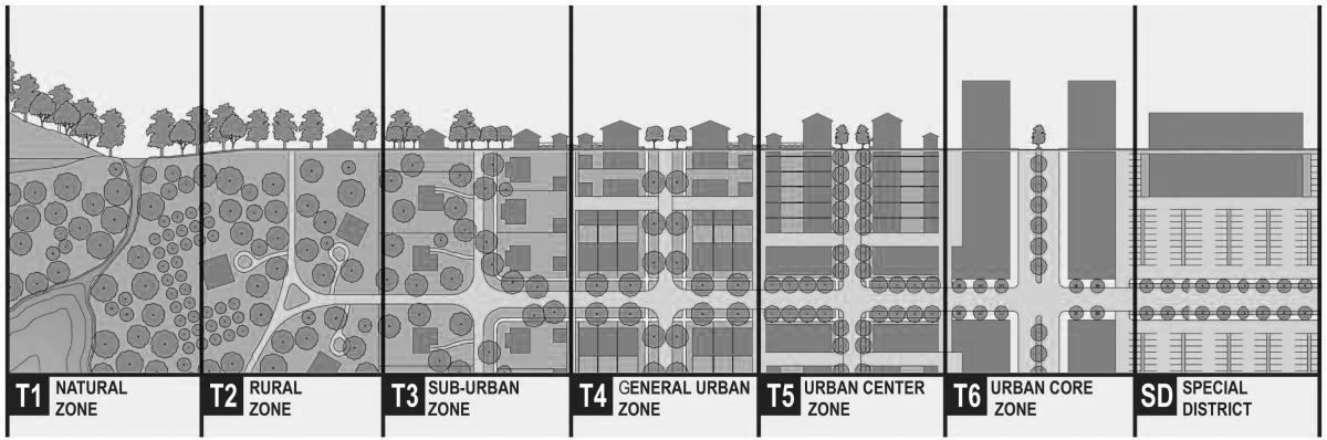
A foundational concept for formbased codes is called the transect, which is a representation of urban densities across a distance.
Traditional transects, as they appeared in the early twentieth century in Massachusetts, centered on a dense, tall urban
core, surrounded by mediumdensity urbanity, surrounded by lower-density urbanity, surrounded by suburban-scale residential build-out, surrounded by rural densities, surrounded by natural landscapes. The transect could be conceptualized for the metro region, or for individual villages, cities, or towns of the region, which typically were settled densely around transit, meeting houses, churches, town halls, post offices, retail, etc.—with the density stepping down away from the center. Current-day transects are a combination of the traditional patterns overlaid with “edge city” that had placed dense development surrounded by parking lots outside of traditional centers, on the edge of town. Proponents of form-based codes support zoning that enables dense development in walkable, transit-served centers, with allowed densities stepping down outside of the centers.
For decades, zoning bylaws and ordinances have significantly outlawed the traditional middlescale densities that would gradually fill in village centers and downtown areas. Form-based codes are used to re-allow these kinds of developments, including twofamily houses, townhouses, small apartment/condo buildings in various formations, etc.
The concept of form-based codes was first proposed by leaders of the New Urbanist movement in
the 1980s. New Urbanists support development of walkable, mixeduse neighborhoods that function and look like traditional urban neighborhoods and downtowns. In the 1990s, some municipal jurisdictions began adopting form-based codes, but not yet in Massachusetts.
In 2005, Abington, Rockland, and Weymouth jointly approved form-based codes to guide the redevelopment of the South Weymouth Naval Air Base into traditional-scale, walkable, mixeduse neighborhoods. The codes were promoted as an exciting new approach to zoning that would bring about old-time, human-scale charm in from-scratch, neighborhoodsized, modern development. The redevelopment has been complicated by many factors, such as those related to water capacity and changing market conditions, and has not been realized as originally promoted by the authors of the zoning code. Later, the redevelopment authority adopted a zoning overlay that would offer more flexibility than the underlying form-based codes. This redevelopment is still a work in progress but never became a significant proving ground for formbased codes per se.
In 2019, Somerville adopted formbased codes. Then Northampton adopted form-based codes for its downtown. Littleton adopted them for its Village Common area, as
well as another district. Several communities, such as Brookline, Newton, Belmont, Watertown, and Bridgewater, have followed their lead, especially passing form-based codes while rezoning to come into compliance with the state’s MBTA Communities zoning law.
This report does not offer a deep evaluation of form-based codes adopted in Massachusetts—neither a comparison of codes themselves nor an analysis of structures and properties built under the codes. Informal critiques of some of the codes have raised common themes. Some of the formbased codes are overly complex and difficult to understand. The complexity can make it challenging for property owners and builders to learn the rules. When the codes are long, it can be tedious to sift through them and figure out what is allowed. This can make the
nonprofessional feel powerless and adds risk to the design process. Some form-based codes have conflicting provisions. The codes can be difficult to administer, especially if no architects and design experts are on staff. At a minimum, building commissioners need training in their administration.
The codes can also be limiting for architects, who might see the codes as overly prescriptive, narrowing their range of allowed building types and architectural features. The codes sometimes are not flexible enough for varied development situations—for example, varied parcel sizes and shapes and locations. Some writers of formbased codes are better equipped than others to understand the design and cost implications of the rules they write.
The many new details of the codes can slow momentum
during the political process, as decision-makers deliberate about each nuanced requirement and alternative variations. The level of detail required for more comprehensive form-based zoning codes makes them more difficult to get approved, given the large number of architectural components that are defined by specific dimensions and accompanying diagrams. A reluctant planning board has that many more decisions to question. On the other hand, adoption of detailed design limits can give local civic leaders comfort in allowing development as of right. Welldesigned projects coming to fruition can help sway decision-makers to allow more projects, rather than cancel zoning for multifamily housing.
“The Transect” (image by the Congress of New Urbanism)
Chapter 40R and MBTA Communities Law
Since the Big Downzone of the 1970s, housing advocates have been working to persuade cities and towns to zone for more multifamily housing as of right. Persuasion alone failed to generate significant local reform.
In 2004, the state adopted a law called Chapter 40R, the Smart Growth Zoning Overlay District Act, to incentivize municipalities to zone for multifamily housing at a density of at least 12 units per acre as of right. The incentives were financial, tied to the amount of housing allowed and built in the new districts. Few municipalities created significant 40R districts to cross many parcels and allow for build-out over time; instead, more municipalities created 40R districts to permit specific proposed projects.15 More housing—in walkable, mixed-use, transitconnected locations—probably made it through permitting with the help of this law than would have otherwise. Overall, however, the law did not lead municipalities to open up their zoning enough to address the housing shortage or change the overall dynamics of the system.
In 2021, the state adopted the MBTA Communities zoning law, requiring cities and towns served by the MBTA (outside of Boston) to zone a district “of reasonable size” for multifamily housing of a gross density of at least 15 units per acre near MBTA stations, where practical. In 2022, the state issued
“implementation guidelines” that defined minimum compliant district size in terms of two parameters, land area and zoning capacity, which is a measure of multifamily units that are theoretically allowed by zoning if every parcel were fully built out to the limits set by the zoning. The guidelines also set implementation deadlines of 2023, 2024, and 2025 for different municipalities. By the end of 2024, more than a hundred municipalities had adopted zoning to come into compliance, some by creating meaningful reform and others by adopting paper districts that would not yield much housing. Approximately 30 municipalities were out of compliance, based on the guidelines, by the 2024 deadline. Some municipalities were waiting for the decision from the Massachusetts Supreme Judicial Court (SJC) about the enforceability of the state law and associated implementation guidelines. In January 2025, the SJC issued a decision confirming that the law is constitutional, mandatory, and enforceable but that the associated guidelines had been adopted without meeting all of the requirements for regulatory promulgation.
The Political Context: A History of Exclusion
Zoning, on the one hand, is full of technical rules, such as permissible dimensions for gable or mansard roofs. But zoning policy is highly political, an arena of passions where people debate into late hours, week after week, whether that extra story of livable space, under the proposed roof dimensions, should be allowed.
Concern about aesthetics is one of many things that animate debates about zoning. At zoning hearings, people often raise concerns about potential impacts on traffic, parking, water quality, mature trees, flooding, schools, privacy, and taxes, among other things. In the history of zoning, fears about loss of socioeconomic status of the whole municipality have sometimes been stated; sometimes such fears are present only as subtext. Classism, xenophobia, nativism, and racism have threaded their ways through zoning decisions over the decades. The state of zoning for design of multifamily housing must be understood in light of concerns about all of these issues; design does not stand on its own, transcendent.
Compliant
“Interim Compliance”
Non-compliant
Compliance map of MBTA Communities law prior to the Supreme Judicial Court ruling (data from the Upzone Update, as of January 2, 2025) [Note that this map is based on the specifications of the “implementation guidelines” that the SJC determined to be legally ineffective.]
Design-Based Zoning
At the root of many of zoning’s shortcomings has been a widespread desire by people writing the zoning to limit residential density, promote car mobility, keep new development far from existing residential neighborhoods, and maintain municipal leverage to negotiate the design of individual projects. In this way, the problem of zoning design is not the technical details of the zoning as much as the politics of zoning adoption. That said, there are approaches to the technical design of zoning that A) are better for the aesthetics of neighborhoods than past approaches, B) make permitting more straightforward, and C) might also capture the imaginations of policymakers more than past approaches have. This is where the proposals of this report come in.
This report builds on the tradition of form-based codes. Indeed, many zoning practitioners would call this report’s recommendations form-based codes. This report calls them “design-based.” The recommendations are a simplified version of form-based codes, so they are sometimes called “formbased lite.” The main difference is that design-based codes do not include “building types” within the requirements. Design-based codes also include fewer diagrams. This report’s recommendations aim to avoid the issues of complexity and the straight-jacketing of design in overprescribed rules. The “formbased codes” recently adopted by
Newton, Belmont, and Watertown, as presented in the short history above, actually fall in this category of form-based lite, or design-based.
The analysis of zoning history shows a need for predictable, as-ofright zoning for small- and mediumscale multifamily housing. Special permits and legislative rezonings have their place in zoning practice. For small- and medium-scale infill projects on many properties in historic suburban centers, though, as-of-right requirements are superior. Design-based zoning lets the zoning reformers shape projects up front, before the projects are even proposed.
As mentioned, the outcome of zoning politics, empirically, is one of exclusion and housing shortage. Municipalities have a long history of using zoning regulations to keep new multifamily housing out of their municipalities, and particularly far away from existing residentialonly neighborhoods. As a warning, regulations aimed at improving the aesthetics and design of multifamily projects can be used to undermine development and raise the price of homes developed—for example, by limiting economies of scale or requiring things that are expensive to build. Zoning regulations often add to the cost of development and make some projects infeasible. Design-based regulations might also function in this way, either on purpose or not.
However, the proposed “added” design regulations of this report would generally not be a new layer of regulation on top of existing restrictions. The new design regulations would accompany rezoning to allow multifamily housing development where it had been banned or had been allowed only through unpredictable and costly discretionary decisionmaking processes. Moreover, it should be the goal to create regulations that are consistent with financially and technically feasible development.
The recommendations of this report are made in the context of a housing shortage and affordability, environmental, and traffic crises. There is an urgent mandate to build more housing in areas where walking, biking, and public transportation can get people to places they want to go. Better design is an end in itself, but it is also a means to gaining political support for more housing. The hope is for improved design controls to help zoning reforms reach the finish line of democratic adoption. Thus, embedded in this report’s recommendations is an understanding of the political context of municipal zoning adoption.
Making a District
The first step of regulating design of neighborhoods via zoning is figuring out where development should be allowed. The idea of this report is not only for by-right requirements to improve the look/ design of approved projects, but also for zoning to yield more project approvals in places where the district design is already excellent.
Massachusetts, in particular, is blessed with hundreds of historic, walkable, mixed-use, transit-served centers. The historic centers typically boast a mix of singlefamily homes, duplexes, multifamily buildings, restaurants, shops, pharmacies, libraries, schools, and civic halls. These areas are generally well connected with relatively continuous sidewalks, and most are served by public transportation. Many are organized around public greens and offer nearby access to public greenspace and sports fields. Many are crossed by rail trails. Mature street trees grace these corridors, offering shade and pleasing cover for less attractive structures. These places are amenable to design upgrades, such as for bike infrastructure, bus shelters, wider sidewalks, and shorter crosswalks. In sum, historic centers are already well designed for a high quality of life, multimodal mobility, walkability, social mobility, and social capital. The historic centers, by their design, are well suited for growth and change.
The region’s historic centers have been built out and rebuilt gradually across at least a couple of centuries. Many are graced with Greek Revival homes and churches dating from the 1830s and other buildings dating from most decades since then. The existing diversity means new multifamily buildings can fit right in with the mix. New buildings will not ruin the character; incremental change and diversity are the character.
Zoning for good design in these places is not generally a task of large-scale redevelopment of whole blocks. The assignment is typically to allow incremental infill. In some cases, block-size redevelopment of certain parcels is appropriate and beneficial, a complement to smaller-scale redevelopment.
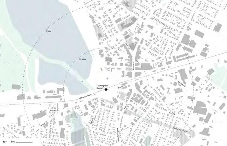
Rezoning for multifamily development should focus on areas in a 10- to 20-minute realistic walk
Framingham map showing actual walksheds versus simple radii from the MBTA station
to rapid transit services (“T” stops, bus routes, rail service, micromobility access, bike infrastructure, and more) and commercial and civic hubs.
In the balance of politics and design, municipalities can tailor subdistricts, each with its own standards, to fit different parcels categorized by various criteria. Some properties within the traditional suburban center are best for by-right zoning for multifamily housing, while some parcels are a better fit for special permits. Some parcels are good for tall buildings, some for low-rise, some for medium-rise. Some parcels should be zoned for first-floor retail (required); some for first-floor retail (optional). In some areas, it makes sense to prohibit retail.
The tools appropriate for the Main Street retail core may be different from the tools best suited for residential neighborhoods adjacent to the core, or for a currently car-oriented, strip-mall corridor that radiates out from Main Street. Within the downtown area, there also may be some unique properties that call for unique zoning. For example, a large industrial property tucked in between tracks, an arterial road, and a river might be a good pick for taller buildings than the municipality would allow on other properties.
This report does not sketch out model zoning requirements for
standardized zoning subdistricts that could be applied across municipalities for, say, “downtown core” (the heart of a Main Street retail area), “medium-density transition” (areas generally adjacent to the downtown core), “smallscale multifamily residential” (infill in residential neighborhoods near the downtown core), and “redevelopment incentive” (properties where a municipality allows high-density housing as an incentive to realize redevelopment of decaying, dated structures or where larger-scale development is especially appropriate).
Development of standardized model zoning would be a next step, to follow this report. It would be helpful for municipal public officials to have model zoning for different categories of parcels; then the task of rezoning would focus on categorizing parcels for those subdistricts, more than on designing unique dimensional requirements and writing unique standards. In any case, these tools should ideally be put in place ahead of development proposals, for predictability, and to bolster capacity for multifamily development. In the absence of model codes and model criteria for applying them, this report offers a methodology for developing local dimensional requirements that fit unique areas.
Not every parcel within walking distance of a center/downtown needs to be treated the same by the
zoning. Politically, a tailored zoning plan may be better supported than one that bluntly treats all properties the same. The idea is not to use every possible reason to reduce allowed densities but to identify, in good faith, those properties where higher densities are most appropriate, both in terms of design and politics.
Zones tier down to smaller-scale, single-family neighborhoods.
Denser zones come with allowances for larger footprints and taller buildings.
ZONE 1
ZONE 1
ZONE 2 EXISTING NEIGHBORHOOD
New zones should be designed so that the buildings are consistent on both sides of the street.
ZONE 2 EXISTING NEIGHBORHOOD
Key Considerations
The following sketches out considerations for sorting specific parcels within the walkshed of commercial-civic-transit hubs into different subdistricts that would have differing requirements for buildings:
1. Location on the transect.
Closer to the heart of a neighborhood, where transit, retail stores and restaurants, civic buildings, and parks are located, the zoning can allow for the greatest density, then taper to lower density farther from the center. This tapering is not a hard rule; sometimes there are good reasons for lower-density requirements right on Main Street, with higher-density allowances a quarter-mile walk from transit and stores, for example.
2. First-floor retail.
Zoning reformers should consider if a parcel must have first-floor retail space or if it should be allowed to have first-floor retail space. In general, it is most important to require mixed use on blocks that currently have active retail, like in the core commercial area of a historic Main Street.
3. Proximity to residential neighborhoods.
Zoning reformers should consider the location of parcels relative to existing residential neighborhoods. There is nothing wrong with diverse housing densities (like single-family homes, duplexes, and apartment/ condo buildings of varying heights and bulkiness interspersed), from a design perspective, within any given neighborhood. However, residents of existing neighborhoods often react negatively to greater densities rising within their existing neighborhood. It is okay to balance this concern of constituents with the benefits of upzoning.
4. Quality and historic relevance of existing structures.
Zoning reformers may consider the historic and aesthetic character of existing buildings. Zoning for density encourages redevelopment of properties. If the municipality would like to retain certain structures, it is appropriate to leave them out of upzoning or to allow dense development on them by special permit. There are also tools in zoning to encourage developers to maintain original structures or original facades, by including density bonuses in the zoning (more units) in exchange for preservation. While identifying properties to favor for preservation, it is worth also identifying properties that are particularly ready for redevelopment, perhaps containing poorly designed, poorly built, and poorly maintained structures.
5. Visibility of location.
Zoning reformers should identify properties uniquely situated or sized where taller buildings would be inconspicuous, and where new shadows will not be cast on existing neighbors. There is nothing inherently bad, from a design perspective, about tall buildings in and around historic centers; indeed, these are excellent areas for tall buildings. However, the politics of allowing tall buildings are challenging. Fortunately, historic centers contain many properties where tall buildings can be somewhat hidden from view. Also, wider streets may better accommodate their heights.
6. Size of parcel and potential for public access of parcel.
Zoning reformers may consider the size of parcels and whether there will be a need for a given parcel for the municipality to negotiate public access for a parcel. In some cases, for large parcels or parcels that could use a public cut-through or benefit from
a public-access plaza, density should be allowed with a special permit, to give the municipality the opportunity to put conditions on the permit. Alternatively, as-of-right zoning for such parcels could be written with detailed instructions for the infrastructure and open space; this would take a lot of up-front planning, which might be worthwhile for parcels likely to be redeveloped in the near term.
7. Existing retail on the parcel. Zoning reformers often evaluate the vitality of current retail in considering zoning requirements. For example, on a block with thriving and cherished businesses, the municipality might not want to encourage near-term redevelopment by allowing six stories of residential; a four-story limit might encourage owners of failing businesses to redevelop, while those with thriving businesses might not find redevelopment for four stories worthwhile. Proposals to rezone blocks of thriving businesses for high density
could engender opposition to rezoning. On the other hand, in areas where retail buildings are decaying and vacancies are common, the municipality can incentivize redevelopment by allowing significant density. Many municipalities have a block of small, one-story, brick-and-concrete retail stores. In some cases, such blocks are ideal for dense redevelopment, especially where there are many vacancies. In other cases, the small retail spaces, which often have low rents (mortgages on the properties long ago paid off and little money spent on building maintenance), serve an important function in supporting locally owned businesses; redevelopment will likely bring fewer, larger retail spaces that go for higher rents (low rents for small shops usually will not cover the cost of construction). It is appropriate to consider these alternatives when rewriting the zoning requirements.
Design Tools
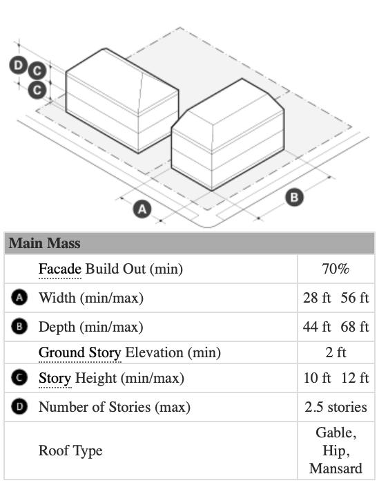
Maximum Footprints
Overview How It Works
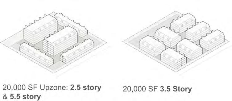
Most zoning bylaws do not address the bulkiness of a building. Developers often bulk out the buildings within the requisite setbacks from property lines. Regulating by units per acre could encourage developers to merge multiple adjacent properties, to build to scale. Setting a maximum footprint for buildings, perhaps to the size of the neighborhood’s larger historic buildings, can protect the “fine-grained urbanism” that is the legacy of historic downtowns.
Also, rather than fixed typologies (specification of “building types”) in the zoning code (which preclude design/development experimentation), a maximum footprint establishes similar bulk limits within a more flexible code. In combination with height limits— rather than limits on the number of dwelling units—maximum footprints give builders more flexibility to respond to market signals. Builders can determine the number of dwelling units within the allowed building envelope, based on market considerations rather than fixed assumptions. So, in some cases, a greater number of smaller units will maximize profits; in other cases, a smaller number of bigger units will maximize profits.
The maximum footprint per zoning subdistrict would be in the zoning code and defined in square feet. Party-wall buildings would count as multiple footprints as long as their definition by the building code is as separate structures (this allows point access blocks or row houses in sequence).
Sample Definition:
Area of the largest above-grade floor of the building, as measured to the exterior faces of the walls.
Steps:
1. Decide what square footage(s) makes sense for the district(s) being worked on.
2. Add this number to existing zoning tables or into existing zoning text.
3. Decide how much space should be left between buildings.
Additional Considerations
Of all the design-oriented regulations proposed in this report, the maximum footprint may be particularly burdensome, undermining the ability of builders to achieve economies of scale. Each building may need its own staircases and elevators, adding cost to each dwelling unit. This tool should be used with consideration of those market realities to other building-code or financing thresholds. But footprint regulations can respect both what can pencil out and what feels best for the neighborhood.
Make sure multiple buildings are allowed on a single parcel; otherwise, the code will penalize large parcels.
18’ Max. Height
11’ Typical Height
11’ Typical Height
11’ Typical Height
15’ Max. Height
RIGHTOFWAY
One method of further refining the building separation distance to accommodate multiple scenarios would be to proportionally tie its minimum width to the heights of adjacent buildings—that is, requiring a wider width when the buildings are taller and a more narrow spacing when they are shorter. When buildings are of different heights, the average between them can be used.
12’ Max. Height
11’ Typical Height
11’ Typical Height
11’ Typical Height
15’ Max. Height
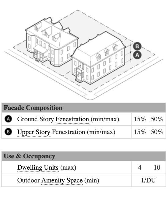
Design Tools
Maximum Building Height and the Half-Story
Overview How It Works Additional
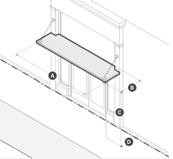
Setting the maximum height of a zone (as defined by stories) pairs with maximum footprint to be the primary means of density control, under the design-based approach.
The design-based code addresses the height of buildings in a few ways. First, it sets height in feet and stories. Second, it creates requirements for the top story and lowest story (ground story, or first story). These requirements work together to make the building perform better architecturally and urbanistically.
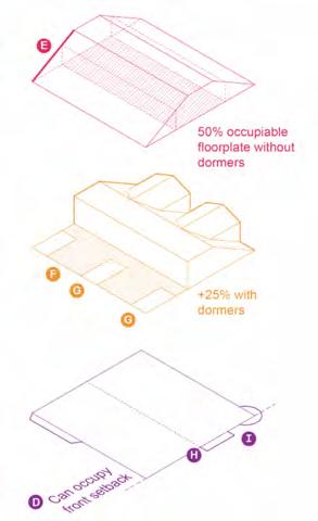
At the top, zoning allowances for “half-stories” or “plus-stories” can make for interesting and varied rooflines, encouraging designs beyond the basic flat roof. These requirements allow for a top partial story of livable space under a gable roof, mansard roof, or setback from the front facade. The partial story makes height less conspicuous, especially from the adjacent sidewalk. Some public officials/ constituents who are wary of building height may be more easily persuaded to allow an additional partial story than to allow another whole story.
The maximum stories are defined by number and in feet.
The half-story is defined through text and a visual diagram to explain the options of either setting back to allow for a terrace (six feet is a commonly accepted minimally usable space) or setting back for a sloped roof (but not a mansard roof or one with a greater slope than the definition).
Sample Definitions: For pitched roofs: At least two opposite roof planes are pitched toward each other. The slope of any pitch must be no greater than 14:12 (49.4 degrees); otherwise, this story is counted as a full story.
For setback top stories: A recess of an upper-story facade a set distance behind the facade of the story below.
Considerations
Further setbacks to adjacent districts could be embedded here, such as requiring buildings to step down a full story when they are within a certain distance of an existing residential zone.
In combination with the pitchedroof requirements, dormers should be allowed to increase the amount of livable space on the top story.
At the ground floor, requiring a minimum floor height for retail (such as 15 feet) is crucial to laying the groundwork for future mixed-use activation (even if it is not part of the initial build-out).
RIGHTOFWAY
Additional height restrictions can be added for parcels that abut residential zones.
If implementing maximum heights in stories and feet, make sure that the maximum allowable height in feet aligns with generous floor-to-floor heights.
Design Tools
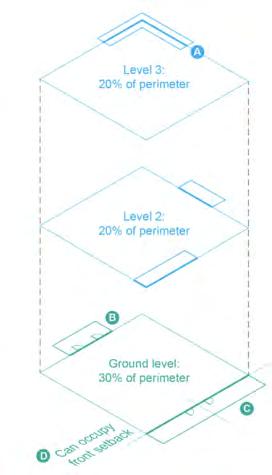
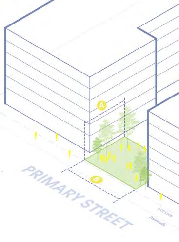
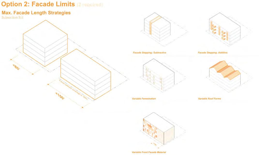
Facade Build-Out Ratio
Overview How It Works
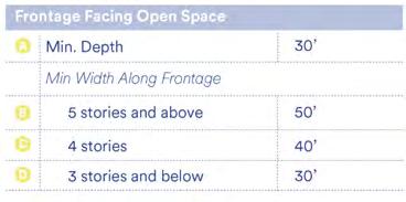
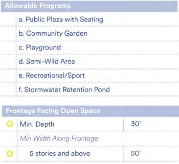
The minimum facade build-out ratio requires buildings to be sited so that they are facing primary streets, contributing to downtown streetscapes.
Typically, the facade build-out is set as a percentage of the length of the front lot line, requiring a certain amount of the lot line to be taken up by a building facade, rather than parking or green space. This rule can be used in conjunction with mandatory ground-floor commercial zoning to revitalize downtown commercial districts.
The width of the front elevation must be built out to a percentage of the lot width, as specified by the facade build-out ratio.
Sample Definition:
The ratio of the width of the entire front elevation to the lot width along the right of way.
Steps:
1. Decide what ratio(s) makes sense for the district(s) being worked on.
2. Add this number to existing zoning tables or into existing zoning text.
Additional Considerations
Different types of streets might warrant different amounts of facade build-out.
If you are setting a high percentage of facade build-out, to ensure that all parcels are buildable, you should also allow coverage of the “width of the lot between side setbacks minus 15 feet.”
If your code limits the footprint size of buildings, make sure the facade build-out ratio can be met by multiple buildings.
On secondary streets, a lower facade build-out ratio can be used to establish a hierarchy.
Design Tools
Maximum Facade Lengths
Overview
For zones that allow greater building footprints, constraining the maximum continuous facade length can ensure that even larger structures are broken up to fit better contextually in a community.
Typically, the length is set by looking at the neighborhood’s longer historic facades. The requirement would specify that after that length is reached, the building’s designer can select from several prescribed options for stretching a building longer. The first option is to create a notch, of a certain dimension, in the wall or to set back the whole next section of the facade a certain dimension.
How It Works
Set a maximum length of a flat facade in feet and establish dimensions for a minimum break in the facade by width and depth.
Sample Language:
The facade of any building greater than 100 feet in width must be divided vertically by a recess with a minimum area of 96 feet and a minimum depth of eight feet, or a facade offset with a minimum depth of eight feet for the full height of the building, excluding:
• The half-story
• Balconies and awnings that may be located within the recess or adjacent to the offset
Additional Considerations
The setback or break dimension could be further tied to standard balcony sizes or defined as a way to align with a ground-floor, openspace use.
In some cases, material changes on the facade can be counted as a break in the facade. This is something that could be considered if varied facade materials are desired.
JOG
RIGHTOFWAY
INDENT
Define dimensional standards for breaks in the facade.
Design Tools
Minimum Usable Open Space
Overview
Although typical zoning codes have an open-space metric as a way to limit density, this is not necessary with the footprint and maximum building height measures. Minimum usable open space instead works to ensure the project provides adequate private open space for residents themselves.
This can be defined in square feet per unit. Projects can achieve this code by collecting all open space in a shared space or separating it out to private spaces, such as balconies. Often there would be a list of predefined options for the open space; there cannot just be an unusable strip of landscaping along the building’s required setback. The open space can be private or public; shared by all households or private for individual households. Parking and driveways are not included in the calculation.
How It Works
Define usable open space and provide a list of acceptable uses. For example: balconies, terraces, stoops, dooryards, courtyards, dog runs, plazas, gardens, roof decks, and pools.
Determine how much usable open space you would like. This could be based on a certain square footage per unit. For example, if each unit had a six-foot-by-six-foot balcony, that would equal 36 square feet per unit.
Sample Definition:
Exterior space open to the sky (shading devices, structures, and plantings allowed), which is designed and maintained for the use of residential tenants. It is designed to be programmed and used by active or semi-active uses and not as an inaccessible landscape or passive area.
Additional Considerations
Allowing usable open space in site setbacks can make it easier for developers to achieve the metric. It can also incentivize more active and thoughtful design and programming of these often forgotten buffer spaces.
Allow usable open space to be in a mix of private and shared spaces.
SharedDeck SharedDeck
Allow usable open space in the required site setbacks.
Courts
DogRuns
Garden
Pool
Balconies
Upper-Level Patios
Door Yards
Design Tools
Parking Standards
Overview
High parking ratios pose challenges for design, as well as housing abundance. The recommendation of this report is for municipalities to manage parking well at the district level and to not require onsite parking for new development. If parking needs to be accommodated onsite, the real goal is uncoupled parking, such that it is most efficiently used. It either should be sold/rented at market rate—specifically separate from a unit’s cost. Parking ratios should be per unit (and not per bedroom), and a maximum parking ratio may be appropriate to prevent over-parking a project.
Zoning can also be used to limit where parking can go on a site, as well as where driveways can go. Requirements should specify that parking be situated in the rear of buildings, or to the side, but not in the front. Requirements should also provide guidelines for the distance between parking and the edges of the parcel (buffer zones), as well as how the parking is screened.
How It Works
Sample Definition: SCREENING
A visual barrier that may be
• A masonry wall, brick veneer, tiltwall concrete, poured-in-place concrete, with a minimum height of six feet
• A five-feet-high and five-feetwide evergreen landscaping strip
• A landscaped earthen berm at least five feet in height
• A wood fence with permanent slats, at least six feet in height
• A combination of the above
Steps:
1. Decide on a parking ratio or, better yet, leave it out.
2. Establish where parking is allowable onsite and how it should be screened from neighbors.
3. Establish curb-cut dimensions and location requirements.
Additional Considerations
Consider adding bicycle parking to your zoning code as well, such as the requirement for one space per unit and some visitor spaces onsite. Incentives or guidelines can define this parking as in-building or protected from the elements in order to encourage its use.
Although the code can set out these standards and provide commentary, it is usually through site plan review that the parking can come into compliance with feedback from the zoning review team.
Consider requiring a break every 10 parking spaces.
PRIMARYRIGHTOFWAY
Consider requiring a buffer zone at the lot line and between the building and any parking spaces.
SECONDARYRIGHTOFWAY BUILDINGFOOTPRINT
Design Tools
Frontage Zones
Overview How It Works
An active ground floor is key to walkable urbanism. Frontage requirements can ensure the ground floor is spatially set up to accommodate both successful retail and residential uses.
Frontage zones are used to define the transition between the public and private realm where the building is set back from the street edge. Requiring developers to decide on a frontage type encourages them to give more thought to the interaction between their building and the public realm.
To further activate the street edge, zoning can be used to require building or unit entries at specified intervals along the facade. More entries helps ensure the ground floor is active and prioritizes pedestrian access from multiple sides.
Define the frontage zone in your code and provide a list of parameters for various types of frontages that should be allowed. These frontage types can then be integrated into a zoning table.
Sample Definition:
The area of a lot between the building facade(s) and any front lot line(s), extending fully to each side lot line(s).
Steps:
1. Establish allowable frontage depths; these will typically vary, depending on the use of the first floor. Typically, residential uses require a deeper setback (six to 12 feet) than active or commercial uses (zero to 12 feet).
2. Establish allowable frontage types; these also will vary, depending on the use of the first floor. For residential uses, some allowable types could be dooryards, stoops, and porches. For active uses, zero lot lines, plazas, gardens, and dining patios could be allowed.
Additional Considerations
For areas where downtowns have narrow sidewalks, zoning can require sidewalks to be widened into the parcel. Codes should define the setback from curb edge instead of lot line to ensure the public realm is consistent across parcels.
Sample Language:
Where a developed lot is abutting a sidewalk that is less than 10 feet wide, buildings must be set back an additional distance so that the sidewalk is at least 10 feet and maximum front setbacks are increased accordingly.
Frontagezone0-12’deep RETAIL+ACTIVEUSES
Consider requiring different fenestration percentages for ground-floor active uses.
Frontagezone6-12’deep
DiningPatio
Garden
Dooryards
Stoops RESIDENTIAL
Porches
Methodology
These tools are open to adaptation for each municipality, as well as for each zoning district or subdistrict in the municipality. Zoning proposals are often written by planning consultants or municipal planners. The research team for this report developed a methodology for architects, in particular, to collaborate in the zoning craft, to tailor the zoning requirements for each municipality, and to help local decision-makers understand the design implications of proposed and existing rules. The architects on the research team tested the methodology in the three municipalities: Canton, Framingham, and Ipswich.
The basic methodology for developing a design-based zoning proposal involves three steps:
1. Analyzing existing conditions, including current zoning and built forms
2. Iteratively running design tests of proposed zoning
3. Writing and diagramming the code
These are steps that architects and planning consultants take to develop a zoning proposal for the planning board and municipal officials to consider. It would be excellent if municipal planners themselves were also trained in the design skills needed to implement this methodology.
1. Analyzing Existing Conditions
Analysis of existing conditions includes A) an analysis of the existing zoning regulations that apply to the area targeted for rezoning and B) an analysis of the existing urban form of that area. These analyses get combined in “development test fits,” which are sketches of what might get built, under the current zoning, on a few sample parcels. The sketches illustrate the look of new potential buildings in the context of the existing streetscapes, including neighboring buildings.
Analysis of existing zoning regulations. The planning consultant will scan the zoning bylaw or ordinance to learn which districts cover the area targeted for rezoning; which uses are allowed by right and by special permit; and which dimensional standards are included for any multifamily buildings that would be allowed by right or by special permit.
Union House / 45,000 SF (Excluding Garage) Bancroft Lofts / 26,000 SF (Excluding Garage)
54 Union Ave / 12,000 SF Graphics used to communicate the typical footprint sizes of new buildings in Framingham (images by Google Earth, 2024)
Analysis of the existing built form. The analysis of the built form should distinguish between prewar development patterns and postwar suburban auto-centric built form, with the larger goal of identifying prevalent building types that can serve as the basis for future design standards. Communities might also analyze the built form in other communities that might serve as a model for future zoning, especially if the area being targeted for rezoning provides little evidence of a coherent built pattern because of postwar redevelopment. Ideally, nonlocal examples are from other communities in the same region to ensure that the building vernacular is culturally relevant.
Development test fits. An architect takes the existing zoning code for a “test drive” by doing development test fits on three or four representative parcels in the study area. The goal of these test fits is not to generate the most contextually or aesthetically
pleasing massing, while following the code, but instead to uncover the unintended design outcomes of the current rule set. The sketches should show buildings constructed to the maximum height allowed and maximum bulk, situated in ways that might not seem ideal but that are allowed under the existing rules. The parking should also be shown in the way it might be built, by the rules. The sketched scenarios will highlight the disconnect between appropriate or desired urban form and what the market might deliver under the existing regulations. In addition, the scenarios demonstrate how existing parking regulations—including minimum parking requirements and the lack of specificity about where parking can and cannot be located—have an outsized and often negative influence on design results. Since pre-existing zoning typically allows multifamily housing primarily by special permit, the test fits will typically model what is allowed by special permit.
These studies not only help to generate ideas for reforms to the zoning, but they also should be used to inform key stakeholders and the general public about the role of the existing zoning in the perpetuation of unintended or undesirable land use patterns. Sharing this upfront analysis with a broad range of stakeholders, including planning boards, city council members, local real estate developers, and the general public, can help smooth the way for discussions about potential new zoning regulations.
1 Grant St / 205 ft
141 Union Ave / 201 ft
46 Irving St / 175 ft
Graphics used to communicate the typical length of historic facades in Framingham (images by Google Earth, 2024)
2. Iterative Design Tests of Proposed Zoning
After the existing conditions analysis is complete and stakeholders have been informed of the issues and weighed in, the design outcomes of alternative zoning rules can be tested using the same parcels that were used to develop design scenarios under the existing zoning. Like the tests of the existing zoning, test fits should attempt to “break the code” by pushing up against the rules in an attempt to maximize development density. This part of the test-fit process can help stakeholders understand what proposed zoning requirements actually allow.
The zoning consultant will draft proposed zoning code to accommodate the desired maximum heights, building sizes (footprints), roof forms, and maximum facade lengths, along with building setbacks. Then the consultant/architect will test the new requirements for compatibility with the existing context. The goal of the rezoning effort is not to create zoning for buildings to perfectly match the dimensional characteristics of existing built fabric, especially if one purpose of rezoning is to increase multifamily housing production.
With these parameters in mind, it is important to write zoning requirements for construction of buildings that are viable enough from a real estate development
standpoint in terms of floorplate sizes and configurations and building heights. Balancing feasibility considerations with the goal of contextual compatibility may mean that the draft zoning allows for buildings that are slightly larger than the historical models and/ or include design standards that require breaking down the building mass into smaller components.
This can be done by establishing maximum facade lengths and/or roof form rules that make larger buildings look smaller. See the “Design Tools” section of the report for these and other suggestions for breaking down the mass of buildings to make them more compatible with the existing urban fabric.
Proctor St.
Proctor St.
FranklinSt.
3. Writing and Diagramming the Code
After the iterative test-fitting process results in a preferred set of rules, the rules should be converted to simple-to-read tables of dimensional standards. Unlike typical form-based codes, which aim to convert all rules to graphic diagrams, a design-based zoning framework should limit the graphic depiction of rules to regulations that are difficult to capture in
textual descriptions with simple dimensions. These include roof form rules, dormers that make a shaped roof habitable, parking and landscape standards, and other rule sets that include more than one dimensional variable or spatial complexity. When committing a final set of rules to fixed code, it is important to still consider and avoid potential loopholes that developers, builders, and their architects might discover. As a result, it can be
helpful to ask a few architects to do test fits that follow the draft code and try to break the code during the process.
Zoning tables from a draft of Framingham’s proposed rezoning to comply with the MBTA Communities law
Testing It on the Ground
The methodology described above was developed and honed by studying different approaches to design-based zoning in targeted areas in Canton, Framingham, and Ipswich. In 2024, municipal planners and planning boards in all three communities were engaged in figuring out options to come into compliance with the MBTA Communities zoning law, which required them to allow multifamily housing as of right. Canton adopted compliant zoning in the spring of 2024, early on during this study. Canton’s new zoning does not include designbased requirements, but it does allow multifamily housing in close proximity to and within walking distance of a train station. By the end of the year, Framingham City Council was still working on a proposal to comply and will likely adopt new zoning in 2025. In the fall of 2024, Ipswich Town Meeting voted to postpone the vote on the zoning proposal until the Supreme Judicial Court issued its decision on the Milton case.
The research team was incredibly grateful to all of the local leaders who listened to their presentations and provided feedback. Local leaders were under time pressure to manage a politically challenging and unprecedented rezoning process. In this stressful setting, leaders welcomed the team and participated in multiple meetings with the researchers. Researchers watched hearings
and political deliberations in all three communities. Both the research project and the rezoning efforts were novel, so there was no preexisting playbook about how to approach the collaborations. The research involved a lot of improvisation and experimentation.
The research team found the graphic comparisons between what could be built under existing zoning versus proposed zoning on specific sites especially helpful. These comparative drawings were the visual tool that best communicated the advantages of a design-based zoning approach to municipal decision-makers. The images also help decision-makers understand what structures the code allows. Most people have a hard time translating text requirements into mental images of potential structures in their context.
Some participants in the planning processes expressed fear of showing visuals of what might be built under current zoning and proposed zoning lest the images motivate opposition to rezoning. There was also concern about when in the process such visuals are shared. For example, if visuals are shared before local stakeholders have reached a consensus on a proposal, there might be suspicions that the planners and outside consultants are trying to advance a pre-established agenda; on the other hand, visuals shared early on can help stakeholders better
understand the options.
With quickly shifting sentiments about the best rezoning approach, it can be difficult to keep up with visuals that reflect the latest ideas; once the people deliberating about options discard an idea that has been visually represented, the old image can serve to confuse, unless it is also either updated or discarded. It might be best to wait until there appears to be some level of consensus from a key portion of local leaders before creating the visuals. Planning boards often start the process of rezoning, but once they have a proposal, other leaders take it from there, and they can react to original proposals with a desire for significant changes.
In each community, the research team tweaked the zoning proposals to best fit the scale of the town. For example, in Ipswich, the team proposed maximum footprints that were smaller than in Framingham, where the existing fabric and historic reference buildings are of a larger scale. In each town, the research team proposed zoning districts in proximity to transit and amenities, stepping down the proposed scale to adjacent residential-only neighborhoods.
Throughout political deliberations, various stakeholders who supported rezoning in Ipswich and Framingham pointed to the design controls as a benefit of potential rezoning. At the same time, many
Canton
Framingham
Ipswich
other constituents expressed a lack of interest in the design controls, while articulating preferences for traditional controls of density. Test-fitting on real lots offered visual casemaking for maximum footprint as an alternative density metric to dwelling units per acre. In practice, though, some neighbors expressed greater concern about the number of units and corresponding households and potential automobiles than the size of the footprint of buildings. Some constituents were concerned that without limits on the number of units, a builder could put in a very large number of micro-studios. Some constituents appreciated the half-story approach, and others advocated for lowering height allowances, dropping the half-story, and decreasing the total allowed story count.
It can be difficult to find local political consensus to rezone historic, walkable, amenity-rich downtowns. There can be more support for finding areas that are both isolated from existing residences and near transit and amenities, or for scattering rezoning sites across a municipality so that one neighborhood does not feel burdened. The flip side of scattering districts is that more neighbors are then engaged to weigh in. In Canton, there were industrial and commercial properties developed with large areas of pavement near a train station—these fit the bill for being isolated yet
offered potential for amenity and infrastructure upgrades. Ipswich considered some areas of the historic downtown, but also an area discreetly outside of downtown. And Framingham explored an approach that included some land downtown, some in two other historic village centers, and some near Route 9.
One tenet of New Urbanism that is generally supported by writers of form- and designbased codes is that fine-grained development, on small parcels, is generally better for walkable, mixed-use neighborhoods than block-scaled development. The recommendation is to do away with minimum parcel sizes. In Canton, the zoning adopted included minimum parcel sizes so that the smaller parcels in the district would need to be merged in order to see development. At one point, Framingham’s proposal also included a minimum parcel size that would leave some existing small parcels out of development opportunities unless combined.
Design-based codes can strengthen stakeholders’ confidence that the zoning will yield development of certain forms and visual scales. This can be politically helpful in getting as-of-right zoning approved. At the same time, each additional component of a zoning proposal can spark fresh debate and potential doubt in the initiative. In Canton, there was strong political
support for the proposed rezoning using traditional dimensional/ density standards, and probably an apprehension about slowing the process to add additional layers of requirements. The zoning Canton adopted allowed greater flexibility and development potential than the design-based standards would have, so this is not a bad outcome. In Framingham, the greater controversy was over what areas to rezone and for what kinds of potential build-out and height; the design standards were discussed positively overall but did not animate participation as much as the mapping of districts did.
Making a District in Framingham
The proposed zoning maps, as shown below, represented a tiered zoning approach. The most dense zones—those that allow taller buildings and larger building footprints—are located in areas that were already built with relatively high density or that have been primarily industrial. The design team used lower-density zoning to transition away from these highdensity parcels (lighter blues), stepping down to the less dense surrounding neighborhoods. The analytical map to the right was used to inform the design team’s proposed zoning map.
4,355 units 50 acres
The research team’s proposed zoning map for Framingham
Mapping existing neighborhoods around the Framingham commuter rail station
Iterative Test Fits in Ipswich
Existing Conditions
0 units
0 dwelling units per acre
0 gross square feet
76 parking spaces
One of the sites chosen to test-fit is 10 Topsfield Rd., a 40,000-squarefoot parcel, currently being used as a parking lot. It is located a fiveminute walk from the train station.
Existing Zoning
18 units
20 dwelling units per acre
24,375 gross square feet
18 parking spaces
Per the existing zoning for Ipswich’s central business district, the building envelope is limited by a 20-unit-per-acre maximum (allowed by special permit only) and the three-story height maximum.
Proposed Zoning
30 units
32 dwelling units per acre
34,400 gross square feet
30 parking spaces
The build-out scheme is limited by the space required for the parking lot at the area and the standard dimensions for residential units. It is also limited by the three-and-a-halfstory height maximum.
Topsfield Rd.
MBTA Commuter Rail
Topsfield Rd.
MBTA Commuter Rail
Topsfield Rd.
MBTA Commuter Rail
Visualizing Test Fits in Canton
Existing Context / Site 1
Existing Context / Site 2
Proposed Zoning Maximums / Site 1
Proposed Zoning Maximums / Site 2
Conclusion
The research team established several conclusions based on its study of zoning reform in Canton, Framingham, and Ipswich.
Less is more.
Although more control and transparency can be achieved by adopting multiple standards for building form, the effort can be self-defeating if not kept in check. Codes must be of a reasonable length and complexity to be understood by the general public and design professionals alike. Inputting too many codes and standards at once could have unintended consequences for their interrelation and, at worst, could prevent projects from happening without variances.
Visualization is key.
Although the zoning code primarily lives in maps and texts, it is difficult for the public to understand the implications of it all. Explanatory diagrams, both two- and threedimensional, reveal the intent behind the text. Realistic test fits of existing zoning and proposed zoning show what can happen or, more specifically, what the worst case might be. Importantly, the test fits should be drawn in such a way that the architectural style is not presupposed and so that viewers can imagine their own reality into the image. Taking views of these from above and at eye level with realistic context drawn in helps assure a level of transparency that can dispel the notoriety that often clouds rezoning.
Work collaboratively.
Buy-in is the name of the zoning game. It is critical for local public officials, planning board members, and civic leaders to feel as if the zoning tools are theirs to use. They must understand how they actually work and feel that they can tweak them in the future. If they do not understand the tools, they might be more likely to revert to the methods they are used to, especially special permit review or limits on dwelling units per acre.
Make the case for design. It is important for proponents of design-based codes to be active cheerleaders for implementation. Proactive leadership from a municipal planner or a wellrespected member of the planning board is essential. It helps to be open and collaborative, but not shy about the need to achieve certain policy goals, such as equity, affordability, walkability, and attractive and appropriately scaled design.
Appendix
Northeastern University Urban Design Studio Course
Overview
Concurrent with the research project, a fourth-year undergraduate design studio was conceived and taught by report coauthor and Associate Professor Tim Love in the School of Architecture at Northeastern University. Entitled “MBTA Communities Housing Law: Designing Zoning for Intentional Urban Design Outcomes” (ARCH 5115), the course assigned teams of students to the same three communities as the research project—Canton, Framingham, and Ipswich—and asked them to come up with innovative, design-based zoning approaches that would meet the requirements of the MBTA Communities Housing Law.
The course helped inform and accelerate the research process in two ways. The first was to provide an opportunity to explore and experiment with a wide range of design-based zoning tools outside of the specific political context of each community, including several unprecedented coding approaches. The course also benefited the research project, because the first point of contact between the planners in the three communities and the research team occurred during student field trips and on-campus reviews of the student work. By reviewing and discussing the students’ creative and nonbinding approaches, the municipal representatives were able to learn about the advantages of design-based zoning
approaches and understand how the methodology explored in the studio might be deployed in their community when on-the-ground decisions were being made.
Course Syllabus
In 2022, the Massachusetts State Legislature passed the MBTA Communities law. It requires all municipalities served by MBTA transit and commuter rail (and communities that border these communities) to adjust their zoning to allow multifamily housing by right at a density of at least 15 units per acre in zoning districts that are at least 50 acres and within a half mile of a transit stop. The law, proposed and enacted during the Baker administration, is a thoughtful and strategic response to the regional housing crisis and is meant to force all municipalities to do their fair share to increase housing production. To say that the policy is controversial in some suburban towns is an understatement.
Although the law is already impacting policy, what is less clear is how the new zoning will affect the urban form of communities that do not have historical models to rely on or where stakeholders champion the status quo because of fear of the unknown. Motivations for NIMBY (not-in-my-backyard) opposition range from concerns about the impact of multifamily housing on property values and the impact of the children who live in apartment buildings on
school populations to barely suppressed racism. The law has been especially controversial in affluent communities, where multifamily housing is fully outlawed or allowed only through labyrinthian permitting processes that favor well-connected and deep-pocketed developers.
The state is already providing some assistance to municipalities to help pass compliant zoning, but not enough to understand the on-theground design opportunities made possible by the law.
One of the chief aims of this study is to demonstrate that important connections can and should be made between urban design approaches and land use policy. Regulatory tools, like zoning and design guidelines, are the primary way that the government controls what can be built on private property. Typical zoning codes control the height and density of buildings, how close they can come to the property lines, and the permitted uses. Although zoning is typically the purview of planners, architects must understand that zoning is a comprehensive rule set that can predict, at least in some ways, a neighborhood’s future urban form and social composition. As a result, the design of zoning codes should be a core disciplinary skill and a more common focus of architectural practice.
Beyond the rules themselves, the vicissitudes of the real estate market have an outsized impact on the ultimate build-out of an urban district. When projects “pencil out” because of favorable market conditions, developers will almost always build the maximum allowable floor area under zoning regulations. Zoning rules should be designed to anticipate that creative developers and their architects will leverage loopholes in the code to maximize their return on their initial investment (cost of land, a consultant team, and debt financing). As a result, architects and planners need to “stress-test” draft codes to ensure that there are no unintended consequences. This desire to “max-out density” can also be used to incentivize the use of architectural components that add more area (and value) above
and beyond the allowable density. In form-based codes, bay windows, dormers, and porches often fall into this category.
Writing a zoning code is no different conceptually from designing a game that others will play, in this case over a protracted time period. One of the important issues to consider is the balance between the intended consistency of urban form on the one hand—as shaped by the code—and the desire for some level of messy vitality on the other—as shaped by the decisions of individual development teams. Some codes, like the design guidelines that shaped the initial build-out of University Park in Cambridge and Battery Park City in New York, aimed for a matchy-matchy consistency. Others are much looser. One
notable example is the code that shaped the single-exposure row houses in the Borneo Sporenburg district of Amsterdam. West 8’s code stipulated only minimum requirements for fenestration areas that combined both windows and skylights. Since each parcel was designed by a different architect, each aiming to create a unique work of architecture, a rich variety of facades were built. The resulting urban street walls (some on canals) have a grain and texture that approximates the messy vitality of urban districts that have been built out over much longer time periods. The West 8 team must have had this aesthetic vision in mind when they wrote the code and knew that an emerging generation of younger architects would find unique solutions in order to advance their own careers.
Tim Love and students meeting with Andrea Bates in Ipswich
Tim Love and students meeting with Sarkis Sarkisian and others in Framingham
Student Work
The 13 students in the class were organized into pairs and assigned one of the three partner municipalities, resulting in two student pairs assigned to each community. Each group researched and diagrammed the existing zoning regulations within the commuter-rail walkshed and then proposed its own compliant MBTA district. The students were encouraged to experiment with zoning tools of their own making, designed especially for the context of each case-study municipality. The zoning codes that resulted incorporated novel dimensional standards and incentives to achieve each student team’s vision of a just framework for multifamily development. The pages that follow feature four projects, one to represent each of the commuter rail stations the students focused on.
Canton Central
Etan Khlevnoy and Lucas Di Cugno
Etan and Luqui proposed a zoning district around Canton Central Station, one of two train stations in Canton. They devised a carefully calibrated tool that allowed higher buildings in the center of the site, if the buildings around the edges were shorter. This tool responds to the shorter buildings that are typical of Downtown Canton’s walkable commercial streets.
George and Michael focused on the areas surrounding Canton Junction, the other station in town. They were interested in incentivizing certain architectural features that promote social interaction and cohesion. To achieve this, they required a certain number of buildings to be wrapped with balconies on upper floors and porches on the ground floor.
Canton Junction
George Danison and Michael Collazo
Framingham
Gabrielle Danitz and Eleanor Garner
In Framingham, the much denser context and opportunities for revitalizing Waverly Street led Gabi and Ellie to propose a tool that required a public open space along the front of any parcel with a frontage wider than 215 feet. This public open space is proportional in width to the height of the adjacent buildings and works with the maximum footprint tool to carefully control the pedestrian experience along Waverly Street.
Ipswich
Evan Diaz and William Blanchette
Lastly, because of the highly varied context in Ipswich, Evan and Billy experimented with “zoning menus,” some of which required certain design elements; in other cases, elements in exchange for extra building height could be added. These flexible “menus” hope to preserve the character of Ipswich, continuing to encourage the varied building typologies that already exist in town.
Citations
1. “Planning Board’s Zones for Cambridge,” Boston Globe, November 20, 1921.
5. Charles Downe, Weston’s Master Plan (1965), https://www.westonma.gov/DocumentCenter/ View/10140/1965-Town-Plan-PDF&sa=D&source =docs&ust=1736215708622082&usg=AOvVaw3 WqMSl3P_bxGdHHjyvDg06.
6. City and Town Centers: A Program for Growth, The Massachusetts Growth Policy Report (The Massachusetts Office of State Planning, 1977), https://www.mhp.net/assets/resources/ documents/massachusetts_growth_policy_ report_-_1977.pdf.
7. Jane Jacobs, The Death and Life of Great American Cities (Random House, 1961).
8. Town of Hudson’s Downtown Plan (1978).
9. Zoning Bylaw of the Town of Winchester Massachusetts, Section 7.3.17 Design Review Guidelines (Winchester Planning Board, 2018), https://www.winchester. us/DocumentCenter/View/3544/ WinchesterZoningBylaw-2018-Springpdf.