We are EXTENTS - a student run creative collective in the landscape architecture department. The collective was formed in 2017 with the goal of celebrating the diverse work of students in the department through an annual print publication. There were 4 publications produced and then there was a pause. A pause not only for the EXTENTS collective, but for the whole world. In fall 2022, some students (us) were sad that there was no collective anymore so we said cool let’s start it again. We created our own vision with the hope to bring more types of creative work to the table and to bring more people together to make rad things. We admit it has been challenging but we are hopeful for what is to come.
We hope you enjoy this small yet mighty edition of the publication. We will see you again next fall.
Nat Gregorius
Chris Copeland
Sarah Chu
Kathy Summers
Erin Wiseman
4 3 EXTENTS LETTITORSPRING 2023 LETTITOR (letter from the Editors) 3 TRANSITIONS / EDGES SUBMISSIONS Ellee Ruder 5 Chris Copeland 7 Seyyada Burney 9 Sarah Chu 11 Lu He, Bing Wan, Jessie Lin 13 Joseph Yates Minsky 15 Justin Sze 17 Kathy Summers 19 Jessika Gill 21 Nat Gregorius 23 EDITORIALS Desk Portraits 25 Big Shape Space Club 27
Decomposition Conceptualization


 Ellee Ruder
This project discusses a fictitious landscape inspired by an excerpt from Italo Calvino's book Invisible Cities as well as a series of com fluid and hair follicles perforating the surface. The work acts as a conversation about burial practices, with ties to the Body Farm phenomenon that's spread across 7 locations in the US as well as the Bleeding Fairy Cap Fungus. Pods found under the ground are a proposal for a burial practice that would allow bodies to decompose naturally and reintegrate back into the landscape. The play in scale is both a reference to invisible Cities and a suggestion of the landscape itself as a singular being.

EXTENTS 6 5
These are drawings, made independently of each other, make new meanings together. They are both about large spaces and infrastructures connected to physicality on a bodily scale.


Milk is apparently so valuable to humans that it keeps the cow suspended in a world-wide economic system. A new ecology emerges,for better and worse. “Economic Ecologies” visualizes values through machinery and spatial relationships.


Some computers can disembody us by mediating our experiences through virtual space. But really, they are very physical tools that we use across all scales. Tractors that work the land are guided by GPS, and our bodies can even be sustained by breathing machines.


“Physical Computing” is meant to embody a contradiction within the power of computing. Their ability to help us organize and coordinate on massive and minute scales is matched by their ability to help us make a really big mess.

EXTENTS 7 8
Chris Copeland
Physical Computing (2020) 30x22” Graphite on paper
Economic Ecologies (2020) 22x30” Graphite on paper
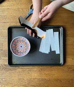
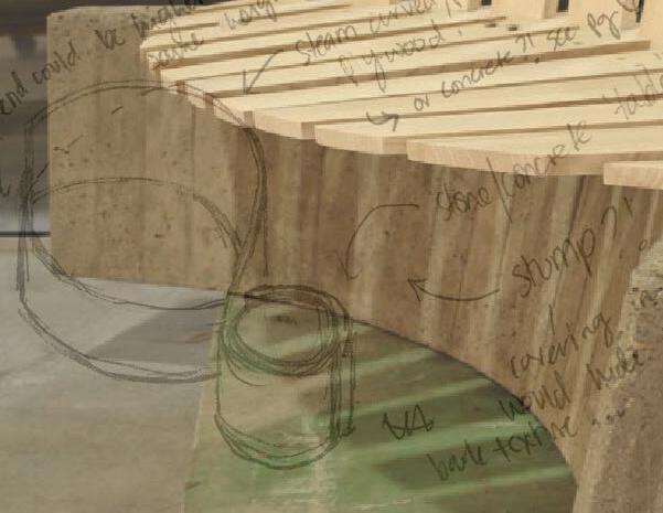
This bench is an exploration of curves and materials. It takes inspiration from a curving path in a residential garden, and is designed around the tectonic assembly of boardform concrete and ash. Iterations on the original curve are represented through process sketches and conceptual and scale models. Material details were resolved through 2D and 3D modeling. Fabrication was completed in 4 weeks.


Media: Cardboard, Papier mache, AutoCAD, Rhino, Concrete + Ash


EXTENTS 10 9
Seyyada Burney FURNISHING THE LANDSCAPE
18-8 Round-head, hex drive steel screws
18-8 Steel washer
18-8 Flat-head hex drive screws threaded through pre-drilled holes and attached to coupling bolt in concrete base
Stack 18-8 Steel washers as spacers between wood seat and concrete base
OCCUPYING SITE: INTERPRETING


SHARED SPACE THROUGH MATERIAL PROGRAMMING


 Sarah Chu
4 To occupy is to...play

At a point in time, an empty dirt construction site became a playfield. Children came and took sticks from the ground and drew lines in the dust, indentations that connected three bases made cardboard and a home plate. The dirt lot was the plane onto which they connected dots (stone, cardboard, pieces of metal) and lines (sticks, wire). Imagination filled in gaps and details and created improvised recreation. On top of years of compacted layers of dirt, there was then large swatches of asphalt, fake turf and gravel. Surfaces were hardened. No longer soft, people came with rollerblades and skateboards and tennis shoes, they pounded the ground, they occupied it through interpretation and expression.
To occupy is to...watch

Eventually other people came, and they watched. The site of dirt became an observational space. Participatory viewing through means of cheering, booing, or silently thinking in the stands. People walking by, stopping to see what the commotion on the site was, the logic of the recreation that was happening. A gathering created.
To occupy is to...share
The site soon accommodated other people and processes. Space occupied different planes and served different communities. Both tension and connection existed. People came and they voiced their opinions, their beliefs and their hopes. Layered on top of the activities of improvisation and observation was sharing and listening. They talked about the people they represented and exchanged stories.
EXTENTS 12 11
existing grade (polluted) prepared subgrade gravel asphalt polished concrete 1”-0” = 10’ ISOMETRIC
DETAIL
LIFT THE GREEN
Lu He, Bing Wan, Jessie Lin


LIFT THE GREEN


The U District is a very vibrant community where many people work, study and live. However, there is not enough green space on University Ave to meet the needs of the people in the community and the existing green space is too far or too small from Ave, resulting in low utilization of the surrounding green space. In addition, as more and more towers are built, the available space on the ground becomes even less.


Therefore, this project proposes to lift the green to the roof, use upper space to create more green factors for the community, provide green views to the U district as well and reduce the urban heat island effect.


EXTENTS 14 13
daily 1-2 days/wk 4-5 days/wk ACTIVE FLOOR FAMILY OFFICE USER WORKERS ACTIVE FLOOR ACTIVE FLOOR PRESENCE AT UD PRESENCE AT UD PRESENCE AT UD ACTIVE FLOOR 5-6 days/wk PROFESSIONALS PRESENCE AT UD STUDENTS 13.2% 31.6% 24.7% 26.4% 18.3% ROOF 98.2% Not used 1.8% Green Roof GREEN p 94.1% Ground Green Space 5.9% Green Roof TOP4 Christie Park TOP2 Ravenna Park TOP1 UW Campus TOP3 Fritz Hedges Waterway Park TOP4 Bulldog News Parklet Bus RouteCampus Area Link RouteResidential Area Mix-used Area Commercial Area Ground Green Space Popular Green Spaces Rooftop Green Space SITE
DESIGN INTERVENTIONPROJECT DESCRIPTION TRANSPORTATION LANDUSE USER GROUP BOOKSTORE RECREATION PLAZA ROOFTOP READING CORNER URBAN VIEW DECK ROOFTOP FOOD COURT COMMUNITY INTERACTION FARMLAND FLOWER RESTAURANT & BAR U DISTRICT STATION POCKET PARK The U District is a very vibrant community where many people work, study and live. However, there is not enough green space on University Ave to meet the needs of the people in the community and the existing green space is too far or too small from Ave, resulting in low utilization of the surrounding green space. In addition, as more and more towers are built, the available space on the ground becomes even less. Therefore, this project proposes to lift the green to the roof, use upper space to create more green factors for the community, provide green views to the U district as well and CURRENTPROPOSEDFUTURE RECREATIONAL TERRACED LAWN U DISTRICT STATION PLAZA APART Phase 1Phase 2Phase 3 GREEN SPACE SITE ANALYSIS Rooftop Usage Rate in UDGreen Space Distribution in UD MobilityCommunity DensityTransit Node Topography Analysis Multi-funtion
0 1020 100ft 1 1 2 2 A B C D E 2 3 3 4 4 4 5 5 6 6 7 7 8 8 9 9 10 10 11 11 12 12 13 13 14 14 U District Station Pocket Park A A' B' B Overlooking the Lounge U District Station Plaza Bookstore Festival Plaza Air Corridor Community Interaction Farming Rooftop Reading Corner Food Court Private Socializing Flower Restaurant & Bar Mobile Vending Areas Recreation Terraced Lawn
MASTER PLAN
Land Down Under
Edges are things that I think of as something to build to, a goal. Work all the way up to the edges. I want to include everything I need all the way up to the edge of the site.


When working on this piece I was imagining a lost land in a sub equatorial jungle that had been swallowed centuries ago. I was imagining that it had been recently discovered and seeing what happens when eco tourists come into the picture. Seeing how different natural elements would interact with more than human occupants and the eco tourists exploring the world.


16 15 EXTENTS
Present day minus 400 yearsPresent day minus 300 yearsPresent day minus 200 years Sacred structure completion Sacred structure building Sacred structure destruction More than human leaving More than human More than human Present day Scale 1/4”=1’0” Tourists More than humans Natural resources Ruins of sacred structure Humand and more than humanPathways Plant Pathways Water Pathways Scale 1/8”=1’0” Scale 1/8”=1’0” Scale 1/8”=1’0” Rain pathway to lower waterway Water eroding structures Plants covering access Hiding structures Hiding view of structures Animal tracks Gathering point Water pass Mountian pass Overall Iscometric Scale 1/8”=1’0”
Joseph Yates Minsky
Latent Changes in Seattle
Historic Chinatown
Justin Sze
Seattle Chinatown is filled with rich cultural history and heritage. It draws people from all over with some of the best Chinese food as well as Uwajimaya, a staple Asian supermarket and one of the largest in the Pacific Northwest. While Covid-19 has forced changes in recent years, the face of Chinatown remains true to its historical past, exemplified in landmarks like the Louisa Hotel, the Freedman Building, and the Panama Hotel. Today, Chinatown is a space under immense pressure from new developments and transit stations. This is not the first time Chinatown has been displaced and this development will only further the division for the community. Most of these changes are visible, however there even more changes concealed behind the buildings.
This project began as a mapping investigation to discover the changes of Chinatown’s urban fabric, behind the facade. Mapping was chosen as the methodology for exploring this narrative because of its abilities to understand the intangible qualities of the built environment. Mapping can help reveal specific characteristics of the built environment –intangible qualities that are beyond scientific data and relate to the cultural life of inhabitants and the spaces they occupy that can best be uncovered in a graphic form. For this investigation, I examined seven blocks in Chinatown and began by researching ownerships history through King’s County parcel viewer. After synthesizing the history, I then cross examined it with Seattle’s history with the hope of finding relationships between major events and trends in changing ownership of the buildings in this range. What I found was astonishing: most of the buildings in Seattle Chinatown were constructed in the 1910s, after the Great Seattle Fire of 1899. continued on next page

EXTENTS 18 17
The Shape of Migration
This composite image explores the shape that’s left behind as a result of migration. I had read about coral reefs migrating north towards cooler waters as a way to escape climate change. They are perceived as stone walls, yet they migrate just as humans do. I wanted to explore what happens in the absence of coral reefs and in the absence of human beings as they transition towards being present in another place.
 what happens in their presence?
20 19 EXTENTS
person
Kathy loss of familiarity, community, friends, family erosion, exposure, pollution
Summers ecosystem altered, culture changes
coral reefgroup of people new ways of living, new relationships survival, growth, maturitynew ways of living, adapting to culture and change
what happens in their absence?
Furthermore, early waves of Chinese immigrants established lasting institutions in the community through benevolent associations, many of which still exist today, such as the Chong Wa Benevolent Association and the Soo Yuen Benevolent Association. These institutions still own some of these buildings in that region today. Another fascinating discovery was that most of the original owners, whether those be associations or individuals, held on to their property for decades, up until the 1990s when there was major economic volatility. In comparison, buildings in Nihonmachi (Japantown) are predominantly not owned by Japanese people, most likely due to Executive order 9066 where Japanese American were forcibly sent off to internment camps.
Bog Bridge
Jessika Gill
The Shoalwater Bay tribe is located along one of the most rapidly eroding shorelines on the Pacific Coast. As a part of the Coastal Adaptations studio this fall, our class collaborated with the tribe on their vision for upland expansion as a way of proactively engaging in disaster preparation as well as community wellness.
Although much of the focus of the studio was on the recently purchased upland property, we felt it was important to maintain connections to the lowlands where the tribe has been active since time immemorial. This cartoon of a bog bridge was presented to the tribe as a ‘kit of parts’ option for pathways that would allow passage in both flooded and dry conditions as the shoreline of Shoalwater Bay shifts closer to the bluffs due to sea level rise, erosion, and/or earthquake activity.


22 21 EXTENTS
Seattle is a part of the larger Western Interconnection utility grid and is largely dependent on energy resources, both extractive and renewable, from other parts of the state, the western region of the country, and across national borders into Canadataking incredibly long journeys from their source to destination. Utilizing energy in Seattle has impacts to landscapes and communities hundreds of miles due to our centralized, majority privately owned energy utility grid. These maps were created to understand and spatialize this energy infrastructure as it is so often obscure to us. This research and visualization is essential to understand the system in order to move towards ways to subvert it via decentralizing, redistributing and localizing ownership of energy to communities, most importantly those on the Frontline of climate change.


24 23 EXTENTS
Canadian Natural *There are many more companies and outside investors/banks fund companies and profit too *Not all of the electricity generating energy projects that Seattle City Light uses is shown *Not to Scale (exists as a representational mapping) *Ownership is bolded & italicized NOTES Suncor Energy ExxonMobil Cenovus Energy Husky Energy MEG Energy Imperial Oil China Offshore Oil Corp. Total China National Petroleum Corp. Corridor Pipeline Inter Pipeline Polaris Pipeline Inter Pipeline Trans Mountain Pipeline Govn’t of Canada Olympic Oil Pipeline BP Northwest Pipeline Williams Company Cherry Point Refinery BP Anacortes Refinery Marathon & HF Sinclair Edmonton Terminal Trans Mountain Athabasca Tar Sands Natural gas extracted via well drilling or fracking in Alberta and British Columbia Natural gas extracted via well drilling or fracking in the Rocky Mountain Region Renewable natural gas from landfill biogas Underground natural gas storage at Jackson Prairie Sumas Terminal Trans Mountain Ross Dam Seattle City Light Diablo Dam Seattle City Light Gorge Dam Seattle City Light Duwamish Substation Seattle City Light Covington Substation US D.O.E. Columbia Ridge Landfill Waste Management Summer Falls Columbia Basin Hydropower Main Canal Columbia Basin Hydropower Stateline Wind Project NextEra Energy Harbor Island, Seattle Kinder Morgan, Shell, Petrocard, Maxum Renton Natural Gas Distribution Pipeline Transfer Puget Sound Energy Seattle Residents Grand Rapids Pipeline TC Energy AOSPL Pipeline Pembina CANADA WASHINGTON Electri city R e finedOil-fuel,he ating Na tura l G asheating,cookin g Ferndale Refinery Phillips 66 Top 10 Companies of 2021 by Barrel Reserve Amount* Buy energy from private companies (Puget Sound Energy and oil distributers) and public not for profit companies (Seattle City Light) Seattle Anacortes Bellingham Sumas to Edmonton, Alberta Olympia Vancouver to Portland, OR to Southern OR to Rocky Mtn Region Richland Spokane Tacoma Natural Gas Storage Crude Oil Pipeline Nuclear Energy Refined Oil Pipeline SCL Hydropower Natural Gas Pipeline Contract Hydropower Contract Renewables Oil Refinery
Tracking Energy Nat Gregorius


26 25 EXTENTS Desk Portraits Sarah Chu
The Big Shape Space Club
Over this past weekend I decided to visit a Seattle art oddity; Untitled Earthwork (Johnson Pit #30). At one point it was a leftover gravel mine, and sat that way for decades. In the 70’s, as part of a land art initiative by King County, minimalist sculptor, Robert Morris, was commissioned to sculpt the space into something new. He razed the site anew and created an enormous terraced bowl space.

There is a lot to say about Morris’ work here as an abandoned gravel mine turned earthwork sculpture, publicly funded no less! But whether this is good art or not isn’t the point here. It’s a striking space, and made me realize that I need to go out and experience what my imagined designs from the studio might actually feel like in person.
It is not very often that such dramatic spaces occur in the city. If they do, the effect can be muted by another gargantuan structure nearby such as I-5 or a new towering development. But nonetheless, the relevance to us as designers is real. We should all spend more time in strangely shaped spaces. I was delighted to hear that a club already exists for this exact reason! The Big Shape Space Club meets once a month, and takes a field trip to a space where the shape dominates the experience. Recent outings have been to Robert Morris’ gravel pit in Kent, the Ballard Locks (when the locks are empty!), and the upcoming trip is headed to the Mima Mounds outside of Olympia, WA.
Formal design dominated our field’s thought at one point, and thankfully there is a strong contemporary movement focused on process. However, we still need to talk about shapes. Shapes can hurt, exclude, hide, and lie. But they can also be part of really smart design. Maybe you think this land art sculpture is the dumbest thing you have ever seen, that’s great! This club is a forum for discussing the merits and problems of big formal design. Throughout our time in the MLA program, we are dealing with space. We all think about form differently, site to site, person to person. But whether you have a light touch or a heavy hand, we are all shaping space in one way or another. I hope to see you at the next meeting of The Big Shape Space Club.
EXTENTS 28 27
Chris Copeland
photo: Chris Copeland
For more information about Morris’ gravel pit, see Kirsten Swenson’s recent essay in Art News titled “From Gravel Pits to Sculpture Parks”