

EXISTING CONDITIONS REPORT 2024

Drafted by: Village of Buffalo Grove Staff
Acknowledgements
Steering Committee
Trustee Andrew Stein
Village Board
Trustee David Wedenfeld
Village Board
Mitchell Winestein
Chair of Planning & Zoning Commission
Neil Worlikar
Planning & Zoning Commissioner
Sujat Saxena
Planning & Zoning Commissioner
Florin Coles
Resident, President of the Resident Board for Cambridge on the Lake
Kyle Olson
Resident Aaron B. Zarkowsky
Resident, Vice President of the Chamber's Executive Board
Sangeetha Subramanian
Resident
Nicholas D. Panarese
Vice President, Van Vlissigen, Corporate Gove Office/Industrial Park
Village Board
President Eric Smith
Clerk Janet Sirabian
Trustee Lester Ottenheimer
Planning & Zoning Commission
Mitchell Weinstein - Chair
Kevin Richards - Vice-Chair
Marc Spunt
James J Sayegh
Principal, Elmdale Partners
Stacey Bachar
Asst Supt for Business Svc - School District 102
Tim Beechick
Hamilton Partners
Pete Panayiotou
Business Owner - Continental Restaurant
Erika Strojinc
Executive Director, Buffalo Grove Park District
Michael Rodriguez
Deputy Chief of Police, Buffalo Grove
Brian Spolar
Deputy Chief of Police, Buffalo Grove
Mike Baker
Fire Chief, Buffalo Grove
Tyler Grace
Management Analyst, Buffalo Grove Fire Dept
Kevin Carrier
Director of Planning and Programming, LCDOT
Trustee Andrew Stein
Trustee David Weidenfeld
Trustee Joanne Johnson
Dane Bragg
Village Manager, Buffalo Grove
Chris Stilling
Deputy Village Manager, Buffalo Gove
Mike Skibbe
Deputy Village Manager, Buffalo Gove
Evan Michel
Assistant to the Village Manager, Buffalo Grove
Nicole Woods
Community Development Director, Buffalo Grove
Kelly Purvis
Community Development Deputy Director, Buffalo Grove
Andrew Binder
Associate Planner, Buffalo Grove
Maya Belorusskiy
Resident, Community Development Intern
Kyle Johnson
Deputy Public Works Director/Village Engineer
Ted Sianis
Assistant Village Engineer
Trustee Frank Cesario
Trustee Denice Bocek
Adam Moodhe
Amy Au
Neil Worlikar
Jason Davis
Sujat Saxen
History, Character and Regional Context 21 Community Outreach
T a b l e o f C o n t e n t s 13
25 Demographics and Housing
39 Land Use and Development
57 Economic Development
65 Transportation
75 Infrastructure and Natural Resources
85 Dundee Road and Milwaukee Avenue Corridors
Looking Forward

Introduction
The Village of Buffalo Grove is a thriving community in the Chicagoland region Its nationally recognized school system and wide variety of amenities elevate the quality of life of families and professionals living in Buffalo Grove. This is partly due to the Village’s undertaking multiple planning efforts in the past to explore its challenges and create solutions to capitalize on its opportunities. To further enhance its success and coordinate the recommendations from past plans, the Village of Buffalo Grove is updating its 2009 Comprehensive Plan with a new plan that will outline the community’s desired development vision for its future as well as actions needed to accomplish that vision. Having an accurate understanding of existing issues and opportunities within the Village is the first step toward developing an appropriate and effective plan that outlines Buffalo Grove’s vision of its desired physical environment and the process for realizing that vision.


Introduction
The Purpose of the Existing Conditions Report
This report on Existing Conditions is a result of extensive research, analysis, and public outreach activities It offers an overview of the current situation in the Buffalo Grove community and is intended to serve as a starting point for developing a shared vision. The report is divided into various sections for easy understanding and organization.
Introduction
Section 1: History, Character, and Regional Context
Section 2: Community Outreach
Section 3: Demographics and Housing
Section 4: Land Use and Development
Section 5: Economic Development
Section 6: Transportation
Section 7: Infrastructure and Natural Resources
Section 8: Dundee Road and Milwaukee Avenue Corridors
Section 9: Looking Forward
Why Does Buffalo Grove Need a Comprehensive Plan?
The current Village Comprehensive Plan was formulated back in 2009 and has become outdated As a result, it can no longer be relied upon as a guiding document for the Village's staff and elected or appointed officials Therefore, a new Comprehensive Plan is needed, that can help the Village take advantage of upcoming development opportunities in a more effective and efficient manner

What is a Comprehensive Plan?
A Comprehensive Plan outlines a community’s vision of its desired physical environment and the process for realizing that vision In addition to providing a well-defined framework for the community’s development and investment goals, the Plan seeks to explore changing community trends, identify emerging challenges, and promote new opportunities
A Comprehensive Plan is a long-term document that outlines a community's vision and provides guidance for achieving that vision over 15 to 20 years. However, the plan should also be used on a daily basis to assist in land use and development decisions. It is important to note that the comprehensive plan should be flexible and adaptable to change. A municipality can update its comprehensive plan at any time to meet local needs, interests, or opportunities. It is recommended that a municipality update its comprehensive plan every five years to ensure its accuracy.
Elements of a Comprehensive Plan
A comprehensive plan is composed of a series of distinct yet interrelated elements defined by the Illinois Local Planning Assistance Act (Public Act 92-0768) This statute will serve as the basis for the Village of Buffalo Grove Comprehensive Plan, primary elements of which will include:
Land Use
Economic Development
Housing
Parks and Open Space
Transportation and Circulation
Corridors
Implementation
Under the Illinois Municipal Code (65 ILCS) 5/11-12-5(1)), a municipal plan commission is responsible for preparing and recommending a “comprehensive plan for the present and future development or redevelopment of the municipality ” The code continues to say “that the plan may include reasonable requirements with reference to streets, alleys, public grounds, and other improvements ”

Planning Process
The planning process to create the Village of Buffalo Grove’s Comprehensive Plan includes multiple steps The process has been crafted by Village staff and designed to include input from residents, property owners, and business owners thro, and other stakeholders throughout

Late Spring 2024
Project Pause and Reboot
The plan was originally kicked-off with a consultant, who started and lead the project Since March 2020, the project was put on pause due to the Covid-19 Pandemic, changing market dynamics, and new developments.
The project was resumed in late Summer of 2023, however much of the information associated with the plan was considered out-of-date. As a result, staff restarted the project almost entirely anew and conducted it in-house This Existing Conditions Report, which was completed in Spring 2024, was drafted by staff and included new projects, reflected the current direction of the Village, as well as included the key information from previous efforts prior to Covid.

Next Steps
Building upon the work that has been completed in the Existing Conditions Report, Village Staff will begin to create a shared vision for the future of the community The key elements of this vision, including recommendations, will be shared with the Village Board and Steering Committee for feedback before proceeding on to the draft plan

Moving BG Forward
Kicking off in 2023, Buffalo Grove embarked on a journey to envision the future of the Village with three major interrelated initiatives - the strategic plan, comprehensive plan and community branding. The key opportunities for synergy among the three projects revolve around outreach activities and initiatives, joint marketing and branding, and information sharing. Through this initiative, the community reached out to 500 unique individuals through our collective and traditional outreach efforts to date. In addition, there was a total of 1,000 campaign engagements and link clicks. Information and data gathered from these efforts have been multilaterally shared and incorporated into each project’s process. Outreach results from the Moving BG Forward Initiative are further discussed in the Outreach Section.

Previous Plans
To ensure compatibility with other local and regional initiatives and optimize the opportunity for future partnerships, the Comprehensive Plan will build off of the relevant goals and recommendations from related Village, county, and regional plans as shown below

CMAP On To 2050 Comprehensive Regional Plan (2018; Updated 2022)
A road map for regional priorities on transportation, development, the environment, the economy, and other key issues such as:
o Inclusive Growth
o Resilience
o Prioritized Investment

Cook County’s Planning for Progress (2015)
A strategic plan to gather additional resources, marshal existing funds, and facilitate partnerships for future housing, community, and economic development needs

Economic Development Strategic Plan (2016)
The plan aims to position the community for economic development opportunities now and in the future and revolves around themes of economic growth, land use, development, and quality of life.
Regional Local
County

A countywide comprehensive plan for managing land use, directing growth, and protecting the natural environment. Lake County Framework Plan (2004)

Annexation Strategy and Plan (2016) And Annexation Strategies Action Plan (2017)
The plans identify and prioritize the several hundred acres of unincorporated land distributed throughout the Village and provides recommendations for future development

Lake-Cook Road Corridor Market Study and Plan (2018)
Outlines a vision for the corridor to enhance the Village's identity, vitality, and fiscal sustainability Utilizing a unique scaled approach, which balances opportunities with market demands, the Plan was approved as a component and update to the Comprehensive Plan!

Prairie View Metra Station Area Plan (2019)
This plan provided a long-term vision for property in and around the Prairie View Metra Station It was approved as a component and update to the Comprehensive Plan

Village of Buffalo Grove Multi-Use Path Plan (2023)
Provides an overview of recommendations for multi-use path maintenance and phasing of future connectivity.

Buffalo Grove 2024-2028 Strategic Plan (2023)
Outlines vision, mission, values & goals for:
Maintaining an Effective Government
Enhancing Neighborhoods
Strengthening Community Identity & Pride
A Vibrant & Innovative Community
A More Livable Community
Local

Buffalo Grove Sustainability Report (2023)
The Sustainability Report is based upon the Greenest Region Compact 2 (GRC2) framework and has specific environmental goals and objectives set by the Village The report outlines how the Village plans to achieve these goals

Village of Buffalo Grove Branding Strategy (2024)
Buffalo Grove’s new brand highlights the village's excellence balanced with a caring, community focus


Section 1: History, Character & Regional Context
This section provides a brief history of the Village of Buffalo Grove and explores the Character of the Village and how Buffalo Grove fits into the larger Chicago region, providing a context for the existing conditions and future vision of the Village.

History
In the 1840s, Buffalo Grove was a dairy farming community, supplying fresh dairy products to the Chicagoland area Many of the early settlers, mainly Roman Catholics, donated money and/or land to build the Saint Mary’s Church in 1852 Although arsonists destroyed the church a few years after it was constructed, the church was rebuilt in 1899. Saint Mary’s Church remains an important landmark in the community today.
In the early 1900s, the railroad lines connecting Chicago and Buffalo Grove were already established Many farmers at that time either took their milk to the J B Weidner’s cheese factory or the train stations at Prairie View or Wheeling to transport their milk to Chicago. These train stations eventually became the present-day Metra stations on Metra’s North Central Service (NCS) line, transporting commuters between Chicago, Buffalo Grove, and the Chicagoland region. In the 1930s, Dundee Road became the first state concrete road in northern Illinois, improving automobile access and creating development along the Dundee Corridor


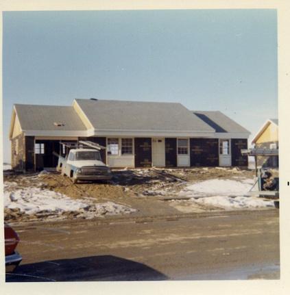
The Buffalo Grove area experienced significant growth during the 1950s as many farmers sold their land to developers who built residential subdivisions. Young families who moved in were returning from World War II and relied on Veterans’ Affairs loans to secure housing. This rapid growth and need for governance of shared utilities and other services led to Buffalo Grove’s incorporation in 1958 Following the Village’s incorporation, the Village grew in population from 164 to 1,492 within two years
Buffalo Grove continued to experience significant growth through large residential subdivision developments between 1970 and 1990, when 24,628 residents moved into the community Most of these developments were traditional single-family homes and included developments such as the Woodlands at Fiore, Windfield, and Old Farm The next wave of residential development occurred in late 1990s into present day, which focused on neo-traditional housing and mixed-use housing developments such as Waterbury, Link Crossing, and The Clove.
Looking South on BG Road (1909).
Buffalo Grove’s demographics have shifted and diversified over the years. The first residents of Buffalo Grove were German settlers. During the boom years, particularly in the 1970s, the community saw an influx ofJewishfamilies.TheJewishcommunityhasbeenan importantpartofthecommunity’shistoricalfabricwith the several synagogues serving the community The 1990s through the 2010s saw another shift and diversification of the population as Asians and AsianAmericansbegantocometothecommunity.TheAsian population currently makes up approximately 20% of the Village’s population, which is significantly higher than other suburban communities in the Chicagoland region.
Buffalo Growth also experienced strong growth in its business community and industrial areas over the past severaldecades TheBuffaloGroveCommerceCenter,a light industrial park, was developed in 1981 with approximately 50 acres of land at Lake-Cook Road and the SOO Line railroad tracks. This area continued to expandeast,west,andnorththroughoutthemid-1980s and 1990s. Today Buffalo Grove’s industrial corridor is regarded as a premier research, development, and advanced manufacturing center in the Chicago region. With national leaders such as Siemens Industry, Inc., Flex, Business IT Source (BITS), and Thermflo, Buffalo Grove has developed a reputation for being home to high-technology and innovative companies and an employmentbaseofover20,000workers.

Inadditiontoindustrialareas,BuffaloGrovehasseveral commercialcentersthathavebeendevelopedoverthe past decades including Town Center, Cambridge Commons,ChasePlazaandPlazaVerde.Althoughthese centers served the Village well for years by providing key shopping and dining for residents and visitors, many centers have been redeveloped or are in the process of redeveloping to provide new modern retail and commercial experiences Such redevelopment projects include NCH, The Clove, and the Bison Crossing/Teslaredevelopmentsite.
Today, Buffalo Grove continues to evolve, as it strengthens its position in the Chicagoland region. In leveraging its strengths, it looks forward towards the next several decades by embracing its new brand tagline: Smart.Withheart.

Character
As part of the 2023/2024 Branding Initiative, a brand narrative was produced that best exemplifies the overall character of the village Below is an expanded version of the Brand Narrative:
Nestled in the northwest Chicago suburbs, the vibrant village of Buffalo Grove perfectly blends a commitment to knowledge with a focus on creating the best life for all of its residents This thoughtful approach pervades across the community and can best be described as Smart With Heart

One of the town’s most cherished features is an extensive network of walkable trails that connect parks and green spaces. Residents revel in the opportunity to explore the natural beauty of Buffalo Grove. Whether it’s a leisurely stroll, an organized sports league, or some fun with the family dog, there are outdoor pursuits for all styles, ages, and abilities. Local golf enthusiasts enjoy Buffalo Grove’s well-maintained golf courses, offering year-round amenities such as the Golf Dome and WF Golf at The Arboretum Club These trails and activities not only promote a healthy lifestyle but also serve as a communal space for residents to connect
The neighborhoods of Buffalo Grove embody the qualities of a tranquil haven quiet, safe, and peaceful Families thrive in this nurturing environment, where the community’s well-being is a top priority The local government’s commitment to safety and efficiency ensures that Buffalo Grove remains a place where residents can enjoy a high quality of life
Speaking of government efficiency, Buffalo Grove is a place that gets things done. From responsive public services to forward-thinking urban planning, the local government takes pride in its ability to address the needs of the community promptly, effectively, and most importantly, with heart.
At the center of Buffalo Grove's educational prowess stand school districts that are a beacon of academic excellence They consistently produce students who excel academically but are also equipped with a sense of community and global awareness Schools across the districts thoughtfully nurture young minds, fostering a culture of learning that is both focused and compassionate
Excellence and innovation are also at the heart of the local economy. Known for its advanced manufacturing and technology centers, Buffalo Grove has become one of the premier industrial and high technology areas in the Chicagoland region and are key drives of local employment and revenue.
Charming bison sculptures are scattered throughout the town, adding a touch of creativity to Buffalo Grove's landscape and serving as cultural landmarks. The Raupp Museum and Community Arts Center inspire and foster the creativity of residents and visitors alike, making Buffalo Grove a place with not only a smart mindset but also a vibrant, artistic heart
Buffalo Grove's tapestry is woven with diverse ethnic threads Throughout the years, the village has evolved into a melting pot of cultures This cultural mosaic fosters a community that celebrates diversity and inclusivity
Excitement brews with the upcoming opening of the Clove development, promising further growth and innovation for Buffalo Grove. This development represents the Village’s dedication to progress, ensuring that Buffalo Grove remains a smart, forward-thinking community with a heart that beats in harmony with the needs and aspirations of its residents.
Buffalo Grove is a shining example of a community that seamlessly blends intelligence with compassion. From its exceptional schools and green spaces to its accessibility and commitment to progress, Buffalo Grove invites you to experience the best that life has to offer, where smart decisions and heartfelt connections thrive in unison. Where every decision and every day is


Regional Context
The Village of Buffalo Grove is located in both Cook County and Lake County The community is approximately 9 5 square miles and is boarded by Long Grove, Vernon Hills, and Lincolnshire to the north; Riverwoods to the east; and Wheeling and Arlington Heights to the south There is also unincorporated land east of the Village as well as smaller sections of unincorporated land that the Village surrounds toward the center of the Village
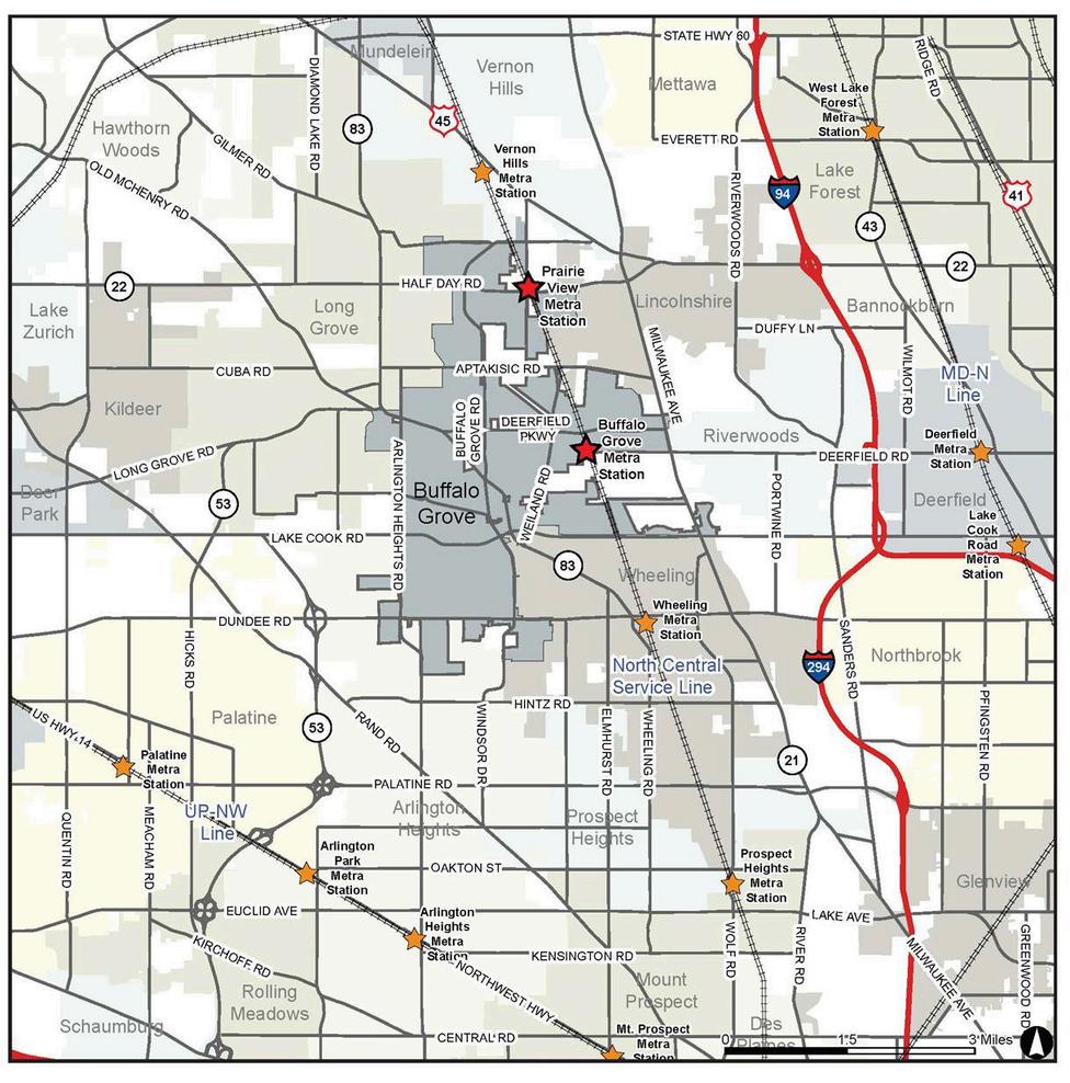
Nearby Transportation Options and Points of Interest
Distances listed are estimated from the intersection of Buffalo Grove Road and Deerfield Parkway (Center of the Village):
Major Interstates:
Interstate 94 – 4 67 miles
Interstate 294 – 4 58 miles
Illinois Route 53 – 3 00 miles
Regional Public Transit:
Buffalo Grove Metra Station, North Central Service (NCS) – 1 23 miles
Prairie View Metra Station, North Central Service (NCS) – 1 88 miles
Wheeling Metra Station, North Central Service (NCS) – 3 09 miles
Arlington Park Metra Station, Union Pacific Northwest (UP-NW) – 5 77 miles
Deerfield Metra Station, Milwaukee District North (MD- N) – 5 91 miles
Lake Cook Road Metra Station, Milwaukee District North (MD- N) – 6 51 miles
International Airports:
O’Hare International Airport – 13.7 miles
Midway International Airport – 29 miles
Regional Airports:
Chicago Executive Airport – 4.55 miles
Other Destinations:
City of Chicago, Downtown – 27 miles


Section 2: Community Outreach
Community engagement is a critical part of the comprehensive planning process. Village staff formulated public outreach strategies that included gathering data from residents, businesses, seniors, youth, and other community stakeholders. Multiple methods for collecting the data were used: surveys, meetings with committees and commissions, focus groups, workshops, etc. Staff also took advantage of the outreach efforts conducted for the Community Branding and Strategic Planning initiatives, which included a wide range of stakeholders at several meetings, focus groups, and one-on-one interviews, as well as an additional community survey. The combined input expressed by these stakeholders will help inform the vision, goals, and recommendations of the final Comprehensive Plan. A summary of each outreach activity is provided in the following pages, and key findings from the outreach efforts are below
Key Findings
Stakeholders desire focal gathering points or centers that are walkable with shops, restaurants and entertainment
Stakeholders expressed a need for more housing types at a range of price points
Art, additional bike lanes/trails and enhanced public transportation are important to BG residents
Residents value diversity, youth and seniors and there is an overall interest in fostering an inclusive community
Stakeholders are encouraged by the development occurring in the Village and hope that it will continue for the remaining underutilized properties
Stakeholders are forward-thinking and value emerging technologies, modern planning, principles, and sustainability measures, all of which include: EV charging stations, solar panels, advanced manufacturing districts, and the integration of green space in development
Outreach

Nov 13, 2019
Public Workshop 1
Sept 12, 2019
Steering Committee
Steering Committee was introduced to the project and asked to identify BG’s Strengths, Weaknesses, Opportunities, and Threats
A public workshop at Aptakisic Jr High School was held to collect ideas regarding the concerns, thoughts, and visons for the future of BG Approximately 46 participants attended including residents, stakeholders, local officials, and business leaders
Aug 23, 2019
Project Kick Off
The Village and consultant met to discuss the project logistics, scope, and engagement
Oct 24, 2019
Listening Sessions/Focus Group Interviews
Various groups of stakeholders were gathered to express issues and opportunities facing the Village. The groups included:
Advanced manufacturing business owners
Business owners and residents along Dundee Rd and Milwaukee Ave
Civic groups and organizations
Local developers and realtors
BG High School’s administration, students, and parents
The Online Platform was set up as a virtual way for stakeholders to provide input into the planning process Participants voiced interest in topics of sustainability, pedestrian and bicycle connectivity, redevelopment, housing diversity.
June 21, 2023
Planning & Zoning Commission Meeting
Staff presented an overview of the Comprehensive Plan process. The PZC provided their perspectives related to land use, development, transportation and other elements as well as Milwaukee and Dundee Corridors
Aug 31 - Sept 4, 2023
Vision & Big Idea Boards BG Days
Interactive boards were displayed at BG days for participants to write down their vision for the future, pinpoint assets and areas for improvements and other big ideas

Spring 2023 - 2025 Moving BG Forward Initiative
The Initiative collectively conducted over 1,100 outreach activities, which included workshops, surveys, focus groups, and meetings to determine BG's identity and future direction.
June 1, 2023
Steering Committee Meeting 2
The meeting reengaged the Steering Committee by reviewing preliminary findings, key changes since the pandemic, and the path forward. Discussion included Buffalo Grove’s strengths, pressing issues facing the community, a vision for the future.
Summer 2023 - Fall 2023
Comp Plan Community Survey
Staff received 655 responses to the Survey, which was promoted through the Village’s communication channels The survey posed key questions including quality of life, future ideas for development, housing and transportation, as well as visions for Milwaukee and Dundee Corridors.
Sept 28, 2023
Youth Survey Civics Forum
Staff engaged 15 local high school students to participate in a Comprehensive Plan Youth Survey, which focused on how and where students like to spend their time, preferred mode of transportation, how to improve BG, and ideas for the future of the community


Section 3: Demographics and Housing
Thissectionprovidesanoverviewofthedemographics,socio-economictrends,andhousingtrendsinBuffaloGrove usingdatafromtheU.S.CensusBureau,theAmericanCommunitySurvey,CMAP,andinformationgatheredfrom thecommunity.
Key Findings
BuffaloGrove’scurrentpopulationis43,000.Itisexpectedtoincreaseby24%by2050. TheVillageisbecomingmorediverse.Whilethemajorityofresidentsarewhite(64%),the Asian population has nearly tripled in the last 20 years. Currently, nearly a quarter of BuffaloGrove’sresidentsareofAsiandecent.
Buffalo Grove has a higher median age (41.2) than Lake and Cook Counties and the Region.NearlyhalfofVillageresidentsarebetween35-64yearsold.
Residentsmaintainhighlevelsofeducationalattainmentasnearly67%haveabachelor’s degreeorhigher. Atthesametime,theVillagehasahighmedianhouseholdincomesof $121,000
Nearly half of all land within the Village is used for housing, with single-family detached housingaccountingforoverhalfofthetotalhousingstock
Buffalo Grove has a high median home value compared to Lake and Cook Counties and theRegionasawhole.
Population
As of the 2020 U.S. Census, Buffalo Grove’s population is approximately 43,212, with an average of 2.6 persons per household. The Village’s 2020 population is a 4% increase over the 2010 population of 41,496. In contrast, Cook County, Lake County and the Chicago region have seen smaller population increases, each at around 2% As noted, the average household size in Buffalo Grove is 2 6 persons per household, which is comparable to Cook County, Lake County, and the Region


The Village of Buffalo Grove has experienced significant growth over the past 50 years and this growth is expected to continue The community’s population is projected to increase by 27% to 54,754 by 2050. Cook and Lake Counties and the Region are expected to grow significantly as well (14%, 16%, and 24% respectively) but at a lesser rate than the Village. These models are based CMAP’s 2050 forecast for the Chicago Region, which is based on market conditions, economic analysis, and plan recommendations.
Current population:
43,000

2050 population projection:
55,000

Source: CMAP Demographic Forecast, On To 2050
Race and Ethnicity
Buffalo Grove is continuing to become more diverse. Although the majority of Buffalo Grove residents are white, the Village has a comparatively large Asian population (approximately 24%). In contrast, the Asian population represents approximately 8% of the population in Lake County, 8% in Cook County, and 7% in the CMAP Region Most of the growth in the Asian population in Buffalo Grove occurred over the past 20 years, as this segment of the population has tripled during that time.
Additionally, 7% of Buffalo Grove residents are Hispanic or Latino, and 3% are Black. This is comparatively less than the percentage of Hispanic or Latino and Black residents in Lake County (22%, 7%); Cook County (26%, 23%), and the region 23%, 16%)

Distribution of Race & Ethnicity in BG 2010 vs 2020
Race & Ethnicity Across Geographies, 2020

Sources: 2010 Census, 2017-2021 American Community Survey

Sources: CMAP, 2017-2021 American Community Survey Five-Year Estimates
2010
2020
Age
The distribution of age in Buffalo Grove contrasts that of surrounding counties and the region Notably, it has a smaller proportion of residents (15%) between the ages of 20-34 years old than Lake County (18%), Cook County (22%), and the CMAP Region (21%) At the same time, it has a slightly greater percentage of residents (23%) that are between the ages of 35-49 years old than the surrounding counties and region (19%-20%).
Buffalo Grove’s underrepresentation of younger adults and overrepresentation of middle-aged residents contributes to the community’s median age of 41 2 , This is higher than the surrounding counties and the region which have median ages between 37 and 38 5
Moreover, it creates a strong concentration (45%) of middle to older adults who are between the ages of 35 and 64, which is larger than the surrounding counties and region, which range from 39%-40%.
Overall, the age distribution in Buffalo Grove has not drastically changed since 2010

Age Distribution Across Geographies, 2020

Sources: CMAP, 2017-2021 American Community Survey Five-Year Estimates
45% of BG Residents are between 35-64 yrs


Over two-thirds (67%) of the adult population in Buffalo Grove holds a bachelor’s degree or higher, which is higher than Lake County (51%), Cook County (41%) and the Chicago region (41%). This high level of educational attainment along with the excellent schools in Buffalo Grove contribute to its community character. Residents of Buffalo Grove highly value education.
Distribution of Age Across Geographies, 2020

Sources: CMAP, 2017-2021 American Community Survey Five-Year Estimates
Educational Attainment Employment


Less than 3.1% of Buffalo Grove residents in the labor force were unemployed as of 2021. This is relatively lower than both Cook and Lake County and the Chicago Region, which had unemployment rates of 7.3%, 5.3%, and 6.4% respectively.
Buffalo Grove residents work in a variety of industries The highest share of employment among Buffalo Grove workers consists of jobs within the Professional, Scientific, and Technical Services fields, which employ 13.2% of residents. The next largest employment industries are Health Care and Social Assistance, employing 10.9% of residents, and Manufacturing employing 10.2% of Village residents.

Household Income
Buffalo Grove has a higher household income than the rest of the surrounding counties and region. The Village also has a higher share of households with median household incomes of greater than $100,000.
Buffalo Grove’s median household income is $121,212, which is significantly higher than Cook County ($72k), Lake County ($97k), and the Chicagoland region ($81k)

Income Distribution Across Geographies, 2020

Sources: CMAP, 2017-2021 American Community Survey Five-Year Estimates

Sources: CMAP, 2017-2021 American Community Survey Five-Year Estimates

Housing Occupancy, Tenure & Value
Buffalo Grove has a lower housing vacancy rate than Lake County, Cook County, or the Region with 96.9% of all housing units being occupied. A high percentage are owner occupied (80.6%) versus renter occupied, similar to Lake County (73.8%), but significantly more than Cook County (57.5%) and the Region (64.4%). At the same time, Buffalo Grove has maintained a much higher median home value of $353,100 compared to Lake County ($288,600), Cook County ($278,000) and the Region ($266,600). The median home value in Buffalo Grove has increased by 3.55% since 2011.

Housing Occupancy & Tenure Across Geographies, 2020

Sources: CMAP, 2017-2021 American Community Survey FiveYear Estimates
Sources: CMAP, 2017-2021 American Community Survey Five-Year Estimates

Housing Typology
The Village’s housing developments (single-family and attached) can be organized into six primary typologies, shown below These typologies present a cohesive and comprehensive cross-section of Post-War suburban residential development in the Midwestern United States
The Post-War Building Boom (1940s-1970s)
The Late 20th Century Single-Family Home (1980s – 2000s)
The 21st Century Paired Home (1990s-2000s)
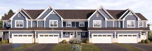
The New Urbanist Townhome (2010s)
Pre-2000s Multi-Family
Contemporary Multi-Family
As shown on the Housing Typologies Map, most of the Village’s existing housing stock is Post-War Building Boom and Late 20th Century Single-Family homes. The Pre-2000s Multifamily is concentrated south of Lake Cook Road and near the Village’s borders. The Village’s newest housing developments (Link Crossing and the Clove) represent the New Urbanist Townhomes and Contemporary Multi-family typologies
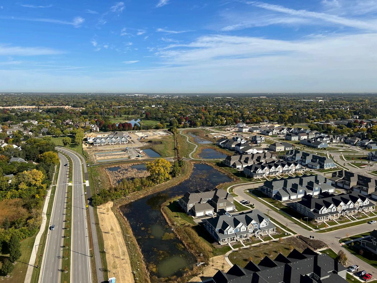
An aerial image of the Link Crossing development nearing completion of construction.
Post-war Building Boom
The suburban building boom following World War II established the ranch-style house, and its variants the Raised Ranch and Split-Level as the dominant housing styles of the latter half of the 20th century.
Its long, low profile reflected American desires for wideopen spaces, with an open layout that embraces a more informal living style. The “model home” design method allowed for rapid construction to suit soaring demand.
Years Constructed: circa 1940s - 1970s
Construction Type: Wood Framed
Exterior Materials: Limited Brick, Wood or Aluminum Siding
Use: Single Family Residential
Height: One Story, One-and-a Half Stories
Parking: One-Two Cars, Attached, in Front / Detached, in Rear

Special Features: Raised Ranch / Split Level allowed for large windows into basement levels, Bay Windows, Picture Windows

Late 20th Century Single Family Home
Towards the end of the 20th century and into the 21st century, residential construction turned toward a contemporary version of American Revivalism known as Neo-Eclecticism. These homes combine a wide array of decorative techniques from an assortment of traditional styles, resulting in a more complex aesthetic than the simple post-war residence.
Much of the revivalist elements are exclusively decorative, while the informal, casual interiors and construction methods of the American Ranch remain. Highly pitched, complex roofs often combine a variety of styles and features including gables, hips, dormers, and special accents.
Years Constructed: circa 1980s - 2000s
Construction Type: Wood Framed
Exterior Materials: Brick, Stone, Vinyl Siding, EIFS
Use: Single Family Residential
Height: One - Two Stories
Parking: Two-Three Cars, Attached, Front or Side
Special Features: Complex Rooflines, Dormers, Prominent Entrance


21st Century Paired Home
The 21st Century has seen a revision on the Neo-Eclectic Single Family Home that focuses on smaller living and reduced maintenance, popular with both “Empty Nest”ers and young families with fewer children
Many of the styles and features of the larger sibling remain, but with two units combined into a single structure, separated by a party wall Smaller lot sizes over increased density and walkability, with less lawn area to maintain Often part of a larger planned development, greater aesthetic harmony exists across several homes
Years Constructed: circa 2000s
Construction Type: Wood Framed
Exterior Materials: Brick, Stone, Vinyl Siding, EIFS
Use: Single-Family Attached Residential
Height: One - Two Stories
Parking: Four Cars, Attached, Front (2 per unit)
Special Features: Complex Rooflines, Dormers, Prominent Entrance
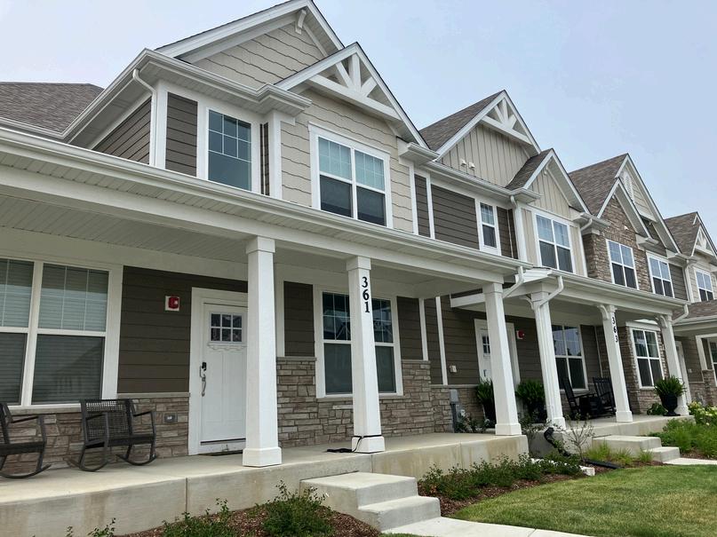
New Urbanist Townhome
Continuing the trend towards denser living and less emphasis on the automobile, this model crafts a next iteration of the 21st century duplex, combining 5-6 units into a single structure Parking is moved to the rear of the house, offering a more traditional curb appear less dominated by the car
Arranged to emphasize walkability, the houses are sited closer to the street, and consistent aesthetics across entire neighborhoods offers a picturesque, traditional scene.
Years Constructed: circa 2010s
Construction Type: Wood Framed
Exterior Materials: Brick, Stone, Vinyl Siding, EIFS
Use: Multi-Family Residential
Height: One -Two Stories
Parking: Two Cars, Attached, Rear
Special Features: Rear patio framed by attached garages visual consistency


Pre-2000s Multi-Family
Pre-2000 multi-family apartments are usually situated within subdivisions of similar-looking apartments The architectural and site design style for this model typically involves generous amounts of green space around each multi-family apartment building They are also usually located within subdivisions, which disconnects them from the surrounding area and activities.
A portion of them feature gabled roofs, which represents an architectural style from that decade. Parking is typically located in surface parking lots.
Years Constructed: circa 1970-2000
Construction Type: Brick and Stone
Exterior Materials: Brick, Stone, Vinyl Siding, EIFS
Use: Multi-Family Residential
Height: Two - Four Stories
Parking: Surface Parking Lot
Contemporary Multi-Family
This model features the densest form of residential uses. This model caters to empty-nesters and young professionals who are looking to live in relatively smaller living spaces than in townhomes or houses. This also includes contemporary senior housing facilities, which includes living spaces and a wide variety of amenities. Parking is typically heated and is located at the building’s basement.
Years Constructed: circa 2000s
Construction Type: Brick and Stone
Exterior Materials: Brick, Stone, EIFS
Use: Multi-Family Residential
Height: Five - Six Stories
Parking: Underground and heated parking lot
Special Features: Common areas may contain shared amenities, such as a gym.


Section 4: Land Use & Development
This section describes the existing land use and development conditions in the Village of Buffalo Grove, zoning practices and impacts, and commercial and neighborhood nodes. The information in this section has been obtained utilizing the Village’s Geographic Information System (GIS) database and CMAP information.
Key Findings
Residential uses are the largest land use in the Village (48%) followed by open space and parks (18%), and industrial (9%)
Buffalo Grove is a community that is organized around civic, commercial, and industrial nodes.
The community has three key commercial nodes, (Deerfield Parkway and Milwaukee Avenue, Buffalo Grove and Dundee Roads, and Route 83 and Arlington Heights Road) as well as a northern and a southern industrial node centered around the Canadian National (CN) Railroad.
Buffalo Grove also has civic nodes, which are key places of identity for the Village. The civic nodes include Dundee Rd & Arlington Heights Rd, Prairie View Metra Station Area, and the triad of civic nodes which include Mike Rylko Park area and the Lake Cook Corridor. This triad represents the heart of Buffalo Grove.

Land Use
LAND USE

Land use refers to the physical use of land, such as residential, commercial, industrial uses or open space
Residential
Residential uses consist of single-family attached, single-family detached, and multi-family residences and are the dominant land use in Buffalo Grove, comprising approximately 3,223 acres of land (53%) in the community. Most of the residential land is singlefamily (90% or 2,919 acres) while the remaining amount is multi-family (10% or 304 acres). The Housing Chapter of this Existing Conditions Report conducts a deeper dive into the residential developments in the community

Multi-Family
Multi-family residential areas include apartment buildings or condominium buildings where units share a common entrance or hallway Multifamily uses in Buffalo Grove are generally located along major corridors such as Dundee Road, Route 83, and Deerfield Parkway and north of Chevy Chase Country Club. Some examples of multi-family developments The Wheatlands, Town Place, Riverwalk North Apartments, and Villa Verde, Oak Creek, and Cambridge on the Lake. Multi-family buildings under construction (or soon to be) include The 225 building at The Clove and the residential building in the Bison Crossing Development
Single-Family Detached
Single-family detached homes are the single largest land use category in Buffalo Grove The homes are organized into neighborhoods or subdivisions that vary from less than 1 acre to over 330 acres in size. These subdivisions include Strathmore, Woodlands at Fiore, Old Farm Village, The Highlands, and many others. Singlefamily detached homes are distributed throughout the Village
Single-Family Attached
This land use consists of townhomes and duplexes The units are horizontally connected but have separate entrances from the public right-of-way and sidewalks. This land use is mostly concentrated in subdivisions that are accessible via some of the Village’s key corridors Buffalo Grove Road, Route 22, Deerfield Parkway, and Route 83. These subdivisions range in size from 1 acre to over 75 acres in size and include Hidden Lake, Chatham, Waterbury Place townhomes, and The Crossings


Link Crossing is one of the Village’s newest residential developments featuring attached and detached single family homes. Link Crossing
Land Use
The Shops at Buffalo Grove
One of the newest commercial centers in the Village, The Shops at Buffalo Grove features over 43,000 square feet of new retail and office space Some key tenants include Starbucks, T-Mobile, Mod Pizza, Chase Bank and Panera Bread.
Commercial

Commercial uses, which make up approximately 5% of the land in Buffalo Grove, include general retail, restaurants, and services that can be tailored to either the local or regional customer base. These uses can be situated within smaller and individual buildings, shopping malls, or other types of shopping center developments Commercial land uses are concentrated along Lake Cook Road, Dundee Road, and Milwaukee Avenue with smaller nodes of commercial activity at Arlington Heights Road and Route 83 and along Weiland Road Some of the major commercial centers are: Woodman’s grocery store site 242,000 square feet, Woodland Commons (171,000 square feet), Plaza Verde (157,000 square feet), the Plaza at Buffalo Grove (134,000 square feet) and the Grove (120,000 square feet).
Office
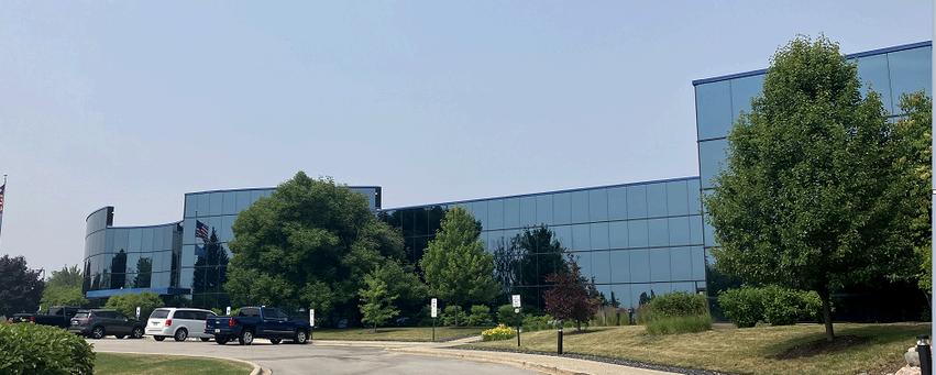
Office uses typically include professional services, employment offices, and medical offices. In Buffalo Grove, office represents approximately 3% of land use and includes standalone office and medical office buildings. Office uses are concentrated along Dundee Road, McHenry Road, and Milwaukee Avenue and include NCH, Riverwalk, Waterford Point, and Buffalo Grove Business Park
Industrial
Industrial land uses represent 9% of the Village’s land use and are generally located in industrial parks (Corporate Grove, Chevy Chase Business Park, Aptakisic Creek Corporate Park) on the eastern part of the Village. This land use includes storage, warehouse, research, light processing or assembly, and manufacturing.
Mixed Use
Mixed-Use refers to a compilation of blended land uses such as commercial, residential, office, open space that are intended to create a sense of place The Clove, which is approximately 22 acres, has a mix of commercial/office (113,000 sf), residential (297 units), and open space ( 8 acres)
St. Mary’s Church
One of the Village’s oldest and most recognized landmarks, St. Mary’s Church and School spans nearly 13 Acres.
Institutional
Institutional land uses represent around 5% of the community’s land use and include a broad range of public and semi-private facilities. These facilities are considered community amenities that define and contribute to Buffalo Grove’s quality of life and shared service delivery These amenities can include government buildings/facilities, religious institutions, and museums The largest of these institutional uses are Vernon Township (15 02 acres), St Mary’s Church and School (12.98 acres), and the Village of Buffalo Grove Clayton Municipal Campus (14.06 acres). This also includes the public and private educational institutions in Buffalo Grove. Buffalo Grove’s school system is nationally recognized and attracts many families to the Village.
Parks and Open Space
Open Space, the second highest land use category, accounts for almost 18% of the land area in the Village and consists of public parks, golf courses and other open spaces. The park system in Buffalo Grove is a highly regarded amenity among its residents. These spaces include a range of facilities such as multi-use trails, athletic fields, playgrounds, neighborhood parks. Also included in this section are the Village’s Buffalo Grove and Arboretum Golf Courses The “Infrastructure and Natural Resources” section provides more details on the parks and open spaces in Buffalo Grove

Utilities and Transportation
Utilities land use designation includes public transportation and utility facilities and makes up approximately 4% of land use. Utilities and transportation are necessary public infrastructure in the Village and are critical to its function. Examples of utilities/transportation uses include overhead utility lines, railroad rights-of-way, the Buffalo Grove and Prairie View Metra Stations
Vacant
Vacant land use includes currently vacant buildings and/or lots within Buffalo Grove and represents a very small percentage of the land within the Village (3%). The largest vacant site in the Village, The Land and Lakes property, is 66.3-acres in area and is located at Milwaukee Avenue and Busch Parkway.

Current Zoning
The Buffalo Grove Zoning Ordinance, which is Chapter 17 of Buffalo Grove’s Code of Ordinances, governs the uses, intensity, and character of land within the Village. It is intended to ensure the public’s safety, health, and welfare by reducing land use incompatibilities, reducing hazards, mitigating nuisances, protecting natural resources and features, and promoting a visually attractive environment within the Village
The Zoning Ordinance follows the traditional zoning standard of single-use districts, meaning that only one type of land use (residential, commercial/ business, or industrial) is generally permitted in each district. These districts include fourteen residential districts, five business districts, one industrial district, and one research and development district The zoning ordinance also has a mixed use planned unit development (PUD) district. PUDs are typically large, integrated developments that allow a mix of uses. Such developments are required to be approved by the Planning and Zoning Commission and Board of Trustees.
Accessibility Code


The Village is sensitive to accessibility issues and concerns. It currently enforces the 2018 Illinois Accessibility Code, which is the most updated accessibility code available. The Code is intended to establish minimum design requirements to ensure that the built environment is designed, constructed, and altered to be accessible to and usable by all, including individuals with disabilities

Potential Areas of Annexation
The Village’s 2016 Annexation Strategy and Plan and 2017 Annexation Strategy Action Plan identified a number of areas that can be potentially annexed into Buffalo Grove The existing land use map shows existing land use patterns in these areas Future annexation and redevelopment occurring in these areas should be sensitive to the surrounding areas ’ current character.


Nodes
Buffalo Grove is a community that is organized around civic, commercial and industrial nodes. Nodes refer to places of commerce, community, and/or identify. They often have more intense uses and or a mix of uses.
Commercial Nodes
Commercial nodes are largely a result of the evolution of the commercial and retail markets. When suburban communities such as Buffalo Grove developed in the 1970s and 1980s, commercial streets/corridors became significant places of commerce, community, and/or identity This ultimately created a linear development pattern. Decades later with the surge of e-commerce and fast casual dining, the need for commercial space dwindled. As a result, activity concentrated near intersections so to benefit from optimal visibility and accessibility. These intersections turned into commercial nodes, or areas of significant activity. Buffalo Grove has three key commercial nodes, Deerfield and Milwaukee (Woodman’s and Shoppes of Buffalo Grove), Buffalo Grove Road and Dundee (The Plaza at Buffalo Grove, Cambridge West, Cambridge Commons), and Route 83 and Arlington Heights Road (Spoerlein Commons and Strathmore Center).

Industrial Nodes
Complementing these commercial nodes are two industrial nodes in the eastern part of town. These industrial nodes are not specific to an intersection but are centered around the rail line and represent the cluster of industrial uses The northern industrial node includes Corporate Grove, Covington Corporate Center, and Arbor Creek Business Center, while the southern industrial node includes Chevy Chase Business Park, Aptakisic Creek Corporate Park).
Civic Nodes
Lastly, there are the civic nodes, which are places of identity for the Village These nodes normally have a mix of uses including a civic use (school, park, etc ) as well as other key landmarks The first civic node is at Dundee Rd and Arlington Heights Rd and is home to Buffalo Grove High School, Strathmore Square, Plaza Verde, and the New Bison Crossing Development. The second civic node is the Prairie View Metra Station Area civic node, which includes Prairie View Metra Station and the neighboring Prairie View neighborhood, Stevenson High School (serves the norther part of Buffalo Grove, but is technically in Lincolnshire), Woodlands Shopping Center, and the Arboretum Golf Club The Village adopted the Prairie View Metra Station Area Plan in 2019, which provides a long-term vision and guidance for this area
Lastly, is the triad of civic nodes, which include Mike Rylko Park area, the Lake Cook Corridor’s eastern edge (The Clove, The Grove, St. Mary’s, NCH), and the western edge (Chase Plaza, BG Golf). This triad represents the heart of Buffalo Grove, with a conflation of higher densities, taller buildings, a mix of uses, a connective greenway, and key BG landmarks/civic uses
The Prairie View Metra Station Area is one of three civic nodes in the Village.

New Development

The Clove, 100-268 McHenry Rd
Kensington Development broke ground in September 2022 to redevelop the 20-acre Town Center property. The new development, The Clove, will be a modern central entertainment and residential district anchored by a 43,000 square foot national grocery store, a 7-story, 297-unit luxury apartment building with 16,000 square feet of commercial space on the ground floor, 65,000 square feet of retail and restaurants scattered throughout the site and a 85 acre “Central Park” in the middle of the site Construction is ongoing with several of the commercial outlots and businesses open and operational The grocer and residential building are anticipated to be completed in 2024 and 2026, respectively

Link Crossing
The new Link Crossing development is located just northeast of the Aptakisic Road and Buffalo Grove Road intersection The development includes 68 clustered single-family detached homes and 119 two-story townhomes

Ricky Rockets - 700 E Lake Cook Rd
The Ricky Rockets commercial development was completed at 700 E Lake Cook Road The project includes a 5,000-square-foot multi-tenant retail building, a 9,000-square-foot gas station and a convenience store, and a car wash
Park Place Townhomes - 400 LaSalle Ln
Three 2-story townhome buildings with 4-units in each building (12 units total) were developd at 400 LaSalle Lane. Each unit is approximately 1,950 square feet in area and features 3 bedrooms, 2 ½ bathrooms and a 2-car garage.
Public Works - 1650 Leider Ln
Work is underway to retrofit the new public works facility, located at 1650 Leider Lane, a former warehouse space that had been vacant for over two years. The Village anticipates dedication and move-in to the new facility will occur fall 2024.


Tesla/Double Eagle Site, 915-945 Dundee Rd
The former Rohrman auto dealerships are redeveloping with a 50,000-square foot Tesla Dealership, 35,000-40,000 square feet of retail outlots and a 200- unit luxury residential building This project is located within the Village's Dundee Road TIF District The project broke ground in spring of 2023

Lazy Dog - 51 McHenry Rd
The former IHOP property is redeveloping into a Lazy Dog Restaurant at 51 McHenry Road The proposed one-story Lazy Dog restaurant will be approximately 7,400 square feet and includes a 1,300 square foot outdoor patio. This project is located within the Village's Lake Cook Corridor and Lake Cook Road TIF District. The project broke ground in spring of 2024.
Prairie Point Townhomes22771-22825 Prairie Road
A new 41-unit townhome community is being developed on an approximately 4.25-acre site on Prairie Road. This project is located within the Village's Prairie View Station Area Plan.

Mike Rylko Park951 McHenry Rd
The Village Board has approved a proposal for the enhancement of the 76acre Mike Rylko Community Park, a collaborative venture between Buffalo Grove Park District and the Village of Buffalo Grove. The Village is contributing $600,000 to the construction, which commenced in fall 2023. Planned improvements encompass the construction of a new amphitheater featuring open lawn seating, a covered pavilion for events, renovation and expansion of the Spray 'N Play facility, as well as the relocation and reconstruction of the existing playground


Self Storage, 105 Lexington Dr
The Village Board approved plans for Buffalo Grove Self-Storage to construct a 4-story, 112,268 square foot, climate-controlled, selfstorage facility at 105 Lexington Drive This site is the parcel north of the existing Ricky Rockets Gas Station Construction began in spring of 2024.
Driven Carwash, 301 Milwaukee Ave
In 2022, the Village Board approved a 5,000square-foot carwash facility at 301 N. Milwaukee. Construction is expected to start in 2024.


Section 5: Economic Development
This section will delve into the economic and market factors shaping Buffalo Grove. The analysis draws from various reliable data sources, including the Illinois Department of Security, U.S. Census Bureau Longitudinal Employment-Household Dynamics, Illinois Department of Revenue, CoStar data and other key data and information.
Key Findings
The Village's economic engine is powered by the manufacturing industry. With over 3,000 workers, the manufacturing industry is the highest share of employment in the Village. The industrial space in the Village is competitive, office space is struggling, while the retail market is stabilizing.
The Village continues to use economic development tools, including increment financing (TIF) to help spur economic development. The Village currently has two TIF districts: The Lake Cook Corridor TIF District and the Dundee Corridor TIF District, which have helped spur commercial developments such as The Clove in Town Center and Bison Crossing.
Overview
Economic Development is traditionally defined as the attraction, retention, and expansion of development and businesses. It requires the alignment of a willing property owner, viable businesses, and a proactive village. Since the adoption of the Economic Development Strategic Plan, the Village has looked to build upon its foundation and optimize its role as a proactive municipality The result is a strong economic development environment, which focuses on advanced manufacturing and mixed-use redevelopment
Employment
Employment estimates indicate that the Village’s 2021 employment base is approximately 17,000 workers. The primary industries that drive employment in Buffalo Grove are focused on five sectors:
Manufacturing; 1 Professional, Scientific, and Technical Services; 2 Wholesale Trade; 3 Retail Trade; 4. Educational Services 5.
These five industries make up roughly 60% of the total employment in Buffalo Grove, each contributing between 7% and 19%, with Manufacturing having the highest share at 19% or 3,120 workers
Driving Buffalo Grove’s manufacturing base and growth is the fairly high concentration of advanced manufacturing in the Village. Advanced manufacturing refers to the emergence of high-tech products and processes in the manufacturing industry. Unlike traditional low-skilled, labor-intensive manufacturing jobs and processes that are vulnerable to off-shoring or automation, advanced manufacturing relies on highly skilled workforce and complex techniques to create sophisticated products that are difficult to outsource
Almost 40% - 45% of manufacturing firms in Buffalo Grove are classified as pharmacy/medical supply, computer electronics, and machinery (including transportation, electrical, and commercial/industrial machinery), which are considered the top three subindustries in advanced manufacturing.
Commercial Development
Buffalo Grove currently has around 11.7 million square feet of commercial real estate Commercial real estate, in this market context encompasses all properties intended for revenue generation and is classified into three primary types: industrial, office, and retail
Industrial & Flex

The industrial sector dominates the commercial real estate market in the Village, accounting for over 7 million square feet, or 63% of the total commercial real estate area. As of 2023, the Village has a relatively low industrial vacancy rate at 6.4%, which is comparable to the North-Central Submarket at 6 5%
Percentage of Vacancy
JLL’s Outlook & Perspective
As noted from their 2023 reports and Board presentation:
Current: The industrial market is tight and demand is high.
Outlook: industrial market will remain strong given larger economic factors and Chicago’s regional status as an nationwide industrial powerhouse.
Buffalo Grove is in a good position in terms of its product, regional location, and reputation
Office


There is approximately 2 million square feet of office space in Buffalo Grove, most of the office space (55%) is Class B. The vacancy rate is around 41%, which is higher than the North-Central Submarket at 38%.
Vacancy Rates
JLL’s Outlook & Perspective
As noted from their 2023 reports and Board presentation:
Current: Demand is low and inventory is shrinking; currently demand is only for the top tier of office product, which represents about 15% of the market, none of which is in Buffalo Grove
Outlook: Current trend of reuses, shrinking, or redeveloping office space is likely to continue.
Buffalo Grove: As none of BG’s office space is within the top tier of the office product, office vacancy will continue to climb, with many buildings being reused and/or redeveloped.
Retail

There is approximately 2 million square feet of retail within Buffalo Grove. The retail vacancy rate is between 6-8%, which is close the vacancy rate within the submarket at approximately 5-8%.
JLL’s Outlook & Perspective
As noted from their 2023 reports and Board presentation
Current: Pre-pandemic trends have been exasperated Older commercial corridors are becoming obsolete and many are looking to redevelopment Sit-down restaurants are struggling, while quick service restaurants are strong.
Outlook: Experiential, niche, and/or convenience will continue to be key drivers of the retail market. Most redevelopment projects will include a mix of uses, particularly multi-family, to help finance projects
Buffalo Grove’s vacancy is slightly high but it is steady
Retail Sales


Buffalo Grove has total retail sales per capita of approximately $23,871, which is higher than Lake County, Cook County and the CMAP Region The biggest generators of Buffalo Grove’s total sales tax are grocery stores as well as building and electrical supplies retailers

Economic Development Incentives
Under the agreement and guidance of the 2016 Economic Development Strategic Plan, the Village continues to explore the use of incentive agreements when warranted, to fill potential financial gaps. These incentives have been in the form of shared sales tax agreements and include Connexion, Hines, BITS, and Woodman’s
In addition, the Village currently has two TIF Districts: Lake Cook Corridor TIF District and Dundee Corridor TIF District. The Lake Cook Corridor TIF, created in 2020, is bounded by Arlington Heights Road, Lake Cook Road, McHenry Road and Checker Drive. The district includes the Grove Shopping Center and Chase Plaza.

The Dundee Corridor TIF, created in 2023, is generally located around the intersection of Dundee Road and Arlington Heights Road and includes the Plaza Verde Shopping Centers, Strathmore Shopping Center, Buffalo Grove High School and the former car dealerships.
Redevelopment Agreements with the developer of Bison Crossing and the Clove were both structured drawing upon the TIFs and sales tax share agreements to fill potential financial gaps for the acquisition of land the development of the projects
All agreements that the Village has structured and implemented, have been structured in a way which did not put the Village at any financial risk or liability for funding a project/enterprise.

Lake Cook Corridor TIF District
Dundee Corridor TIF District


Section 6: Transportation
This section provides an in-depth look at the transportation system currently in place within the Village of Buffalo Grove, covering streets, freight, public transit, as well as pedestrian and bicycle infrastructure
Key Findings
Buffalo Grove has a well-established system of roadways that are extensively used and effectively connect residents within the village, neighboring communities, and the Chicago region
Traffic circulation and congestion mitigation in Buffalo Grove is continuing to improve
Buffalo Grove has convenient and accessible public transit, with Buffalo Grove and Prairie View Metra Stations being critical assets in connecting the Village to the surrounding region
Buffalo Grove has an extensive and well-connected network for bicycles and pedestrians, which is continually being enhanced.
LAND USE
Transportation
Roadway Network
Buffalo Grove boasts a varied network of roadways that efficiently cater to the needs of its residents and workers. IDOT classifies these roadways based on the type of service they are built to provide.
Major Arterials
Major arterials serve vehicles moving at higher speeds for regional trips The major arterials in the Village are generally four-lane roadways with a center median accommodating left-turn movements at intersections, although the eastern segment of Lake Cook Road and the southern segment of Milwaukee Avenue are sixlane roadways. IDOT controls all major arterials except for Lake Cook Road, which is under Cook County control. The major arterials carry traffic volumes ranging from 12,000 to 29,700 vehicles per day
Minor Arterials
Minor arterials serve moderate-to-highspeed travel for regional and local trips to and from residential neighborhoods, commercial areas, employment centers and recreational areas at the community level. The minor arterials are generally controlled by IDOT, Cook County, or Lake County, except for Prairie Road north of Half Day Road, which is under Village control The minor arterials carry traffic volumes ranging from 7,450 to 26,700 vehicles per day.
Collector Roads and Local Streets
The final classifications are collector roads and local streets. Collector roads serve to connect arterials to local streets. All the collectors in the Village have a small or moderate amount of traffic and are maintained by Buffalo Grove except for the portion of Buffalo Grove Road south of Dundee which Cook County controls. All other roads in Buffalo Grove are classified as local streets, which are designed for lower speed and local travel The local streets are also under the Village’s jurisdiction


Truck Routes & Freight Rail
Truck Routes
Truck routes are typically roadways that provide continuous regional travel and/or are designed to support heavy commercial traffic while avoiding residential areas IDOT has established a Designated State Truck Route System that consists of three classifications of roadways (Class I, II, and III), each with specific design standards and maximum legal vehicle dimensions and loaded weights. Buffalo Grove has three Class IIdesignated truck roadways: Dundee Road (IL 68), McHenry Road (IL 83), and Milwaukee Avenue (US 45/IL 21). In addition, the Village has a local truck route system that is concentrated in the Village’s industrial, research, and advanced manufacturing hub along Busch Parkway and Barclay Boulevard and connects private industry with the State truck route system
Freight Rail
The Canadian National (CN) Railway passes through Buffalo Grove and carries approximately 14 to 22 freight trains per day along the double-track railroad which extends in a northwest-southeast direction from north of Buffalo Grove Road to south of Lake Cook Road There are two rail spurs from the railway which lead into the industrial areas.

Public Transit
Residents, employees, and visitors of the Village of Buffalo Grove have access to various transportation options provided by Metra commuter rail, Pace Suburban bus, Wheeling Township, and Lake County on-call bus service.
Metra Commuter Rail
The Metra’s North Central Service (NCS) Line runs on the CN Railway connecting from Union Station in downtown Chicago through various stops including Prairie View and Buffalo Grove Metra stations to the final outbound stop in the Village of Antioch
The NCS line offers weekday service only, which was also the case prior to 2020. However, the service frequency has been reduced since the Covid-19 Pandemic. Before 2020, NCS offered 10 outbound and 9 inbound trains. During the height of the Pandemic, Metra reduced service on various train lines, including the NCS Since that time, some train lines have been restored to nearly the same pre-pandemic service levels At this time, the NCS line remains at a reduced service level of 7 inbound and 7 outbound trains offered on weekdays.
Buffalo Grove, along with other stakeholders and communities participated in the NCS Corridor Analysis and Implementation Study, which was kicked off in 2017 and concluded in spring of 2020. The study reviewed potential service improvements along the NCS line and the financial feasibility to fund the improvements The study identified three possible scenarios for potential service improvements including a range of additional weekend or weekday trains. However, given the dramatic change in transportation patterns and funding priorities, further study would be required to revisit the study’s assumptions, determine the current level of demand for expanded service, and funding priorities for various parties involved
Transportation
Pace Suburban Bus
Pace Suburban Bus provides four fixed bus routes through Buffalo Grove:
Route 234 Wheeling – Des Planes: Weekday service between the Buffalo Grove Metra Station and Des Plaines Metra Station
Route 272 Milwaukee Avenue North: Weekday and Saturday service between Hawthorn Mall in Vernon Hills and Golf Mills Shopping Center in Niles.
Route 604 Wheeling – Schaumburg: Weekday and Saturday service between Pace Northwest Transportation in Schaumburg and the intersection of Buffalo Grove Road/Hintz Road
Route 626 Skokie – Buffalo Grove Limited: Weekday directional rush hour service between the Lincolnshire Corporate Center and the DempsterSkokie CTA (Yellow Line) Station in Skokie
Route 634 did provide service along Lake Cook Road but had historically low ridership. This route was suspended by Pace in 2020.
Wheeling Township offers convenient door-to-door transportation for senior citizens and disabled residents with advance reservations and a fare collected for each round trip. Wheeling Township
Lake County
Lake County provides a reservation-based paratransit service program called, Ride Lake County that offers seniors age 60+ and people with disabilities transportation to any area of Lake County for work, shopping, medical appointments, and more.


Ride Lake County Bus Services
Photo Credit: RTA Chicago
Pedestrian & Bicycle Network
Pe
The net con land hav side unif visu and oth and All Villa side
Bi
Buf trai bicy and enh Gro Mun Tran The Gro
De
A 3 and extends nearly the entire length of Lake County from Russell Road in Wadsworth south to Lake Cook Road in Wheeling where it continues south another 22 1 miles through Cook County to River Grove The trail winds through 12 Lake County Forest preserves.

Buffalo Creek Forest Preserve Trail
A 4.8-mile gravel trail that extends through the Buffalo Creek Forest Preserve.

Buffalo Creek Forest Preserve Trail
BikeTrail
Legend
Bike Trail Map
Travel Patterns & Behavior
Mode of Travel
In accordance with the 2017-2021 ACS, a high proportion (68.8%) of Buffalo Grove residents drive alone to work and approximately 19% work from home. As these numbers were retrieved during the Pandemic years, it is likely that they have shifted but the majority of residents still drive alone to work and/or work from home The Village-wide survey conducted as part of the outreach efforts for the Comprehensive Plan indicates that 25% of the 642 survey respondents work from home and an additional 20% are hybrid (partially work from home, partially in the office).
Ridership on public transportation fell dramatically nationwide during the Covid-19 Pandemic. Some reports indicate that ridership on US public transit was at about 20% of pre-pandemic levels in April 2020 As of spring 2024, the American Public Transportation Association (APTA) were stating that ridership is around 77% of pre-pandemic levels
Pace and Metra’s current ridership are generally at 50% of pre-pandemic levels. In 2018/2019 the NCS line had a daily weekday ridership of approximately 134,600 with Buffalo Grove and Prairie View stations reporting to have the highest ridership of all the Metra stations along the NCS line The Buffalo Grove station had between 640 and 700 boardings and Prairie View had between 420 and 440 Reporting data show that in 2023/2024 daily weekday ridership along the NCS line is approximately 45,100, which is 33% of the prepandemic level.
Ridership along the four Pace bus routes that circulate the village (234, 272, 604, and 634) have fared better with weekday ridership averaging between 55% and 77% of pre-pandemic levels Route 634, was suspended in 2020 and historically had low ridership (approximately 34 average daily trips in 2018/2019)

Transportation Projects
There are several transportation projects within the Village of Buffalo Grove and adjoining communities that are either programmed (funded) for construction/implementation over the next five years or are planned (unfunded) by the Chicago Metropolitan Agency for Planning (CMAP), Cook County Department of Transportation and Highways, Lake County Division of Transportation, Metra and Pace These projects consist of roadway widening and reconstruction, roadway realignment and resurfacing, intersection capacity improvements, traffic signal installation, public transit service enhancements, and bicycle and pedestrian system expansion.
CMAP On To 2050 Comprehensive Regional Plan
There are no Regionally Significant Projects specific to Buffalo Grove that are included in the On To 2050 Comprehensive Regional Plan as priority (fiscally-constrained) projects eligible for Federal funding and Federal approvals There is one fiscally-unconstrained project that will require more study before being included within the fiscally-constrained portion of the plan
Regional Transportation Authority (RTA) Invest In Transit the 2018-2023 Regional Transit Strategic Plan
This plan was adopted in 2023 after two years of development. Priority projects include upgrades to the RTA’s system in general which would improve efficiencies and travel times along routes affecting Buffalo Grove and improve rider experience and information.
Regional Transportation Authority Community Planning Program
Mundelein-NCS Corridor Study – Study of service/ frequency enhancements to the North Central Service Line Part of the RTA’s 2018 Community Planning Program and jointly funded by the FTA, RTA and Village of Mundelein Three service improvement scenarios were identified and are intended to be explored further.
IDOT FY 2025-2029 Proposed Highway Improvement Program
Transportation releases a five-year transportation funding plan which is updated annually Items affecting the Buffalo Grove area and region within the plan include improvements at the intersection of Buffalo Grove Road, parts of Dundee Road and Half Day Road (Rt 22)
IDOT Strategic Regional Arterial Studies
IDOT's Strategic Regional Arterial Studies within Buffalo Grove are as follows:
Milwaukee Avenue (IL 21): proposed road widening to three lanes in each direction with a raised median and sidewalk, requiring reconstruction of the Aptakisic Creek bridge.
Lake Cook Road Raupp Boulevard to East: ultimate configuration is a six-lane roadway with dual left-turn lanes and extended Weiland Road
Lake Cook Road Raupp Boulevard to West: Phase I Engineering studies ongoing to determine if the roadway will require widening to six lanes
Half Day Road (IL 22): largely completed four-lane configuration, remaining intersection improvements at Main Street and Buffalo Grove intersections.
McHenry Road (IL 83): a four-lane roadway with a raised 18-foot median, capacity improvements not yet implemented.
Cook County Department of Transportation and Highways FY 2018-2023 Proposed Transportation Improvement Program
Lake Cook Road will undergo roadway rehabilitation and ADA improvements in 2023 between Arlington Heights Road and Raupp Boulevard. Phase I Engineering studies for Lake Cook Road west of Raupp are underway, yet there is no funding for Phase 2 Engineering or Construction.
Lake County Division of Transportation FY 2022- 2027 Proposed Highway Improvement Program
Aptakisic Road – Roadway widened to 5 lanes with new 8-foot bicycle path on north side and 6-foot sidewalk on south side. The stretch is 1.25 miles, running from IL 83 to Buffalo Grove Road.
Arlington Heights Road – Roadway reconstruction, new non-motorized accommodations; 1.4 miles from IL 83 to Lake Cook Road
Buffalo Grove Road – Roadway reconstruction, new non-motorized accommodations; 0 6 miles from IL 83 to Deerfield Parkway; and 1 5 miles from IL 22 to US 45
Deerfield Road – Roadway reconstruction and widening, new non-motorized accommodations; through Riverwoods from Milwaukee Avenue to Saunders Road.
Prairie Road – Roadway reconstruction, widening to four-lanes with median, intersection improvements, new non-motorized accommodations; 0.9 miles from Aptakisic Road to IL 22.
Lake County’s 2040 Transportation Plan
Lake County's 2040 Transportation Plan proposes several improvements, including widening Milwaukee Avenue, providing bus transit service on IL 22, and adding several bikeways. The bikeways include Lake Cook Road Bikeway, Arlington Heights Road Bikeway, Aptakisic Road Bikeway, Weiland Road Bikeway, Prairie Road Bikeway, ComEd ROW Bikeway, Deerfield Road Bikeway, and IL 22 Bikeway.
Village of Buffalo Grove Infrastructure Modernization Plan
Plans are in development for the next phase of the Infrastructure Modernization Plan
Bernard Drive – Roadway reconstruction for 1 4 miles with 8’ multi-use path on south and 5’ sidewalk on north Construction between 2024-2025
Buffalo Grove Road Utilities and Drainage Improvements Project – Upgrade water, sanitary and storm sewer infrastructure along Buffalo Grove Road from Lake Cook Road to Dundee Road.
Cambridge Court Lift Station Decommissioning Project - Abandon Cambridge Court lift station.
Lake Boulevard Sanitary Sewer Upsize Project – Replacing sewer along Lake Boulevard in the Cambridge on the Lakes Condominiums.
OTP / Raupp / Golfview Basin and Route 22 Lift Station Improvements - Abandon current Raupp and OTP lift stations, build new Raupp lift station with new sanitary line, modify Route 22 lift station, rehab Golfview lift station, construct new Golfview/Raupp basin overflow, replace current Raupp and OTP force mains
St. Mary’s / Marylu Area; White Pine Area; Mill Creek Area; Rolling Hills Area; Water Main & Street Improvements Project – Street resurfacing, storm sewer improvements and water main replacement Diane Drive; Dunham Lane; Weidner Road; and MacArthur Drive: Water Main & Street Improvements Projects – Street resurfacing, storm sewer improvements and water main replacement.


Section 7: Infrastructure & Natural Resources
This section provides information on the environmental features and systems in Buffalo Grove. This information was obtained from CMAP, the Illinois Environmental Protection Agency (IEPA), and other national, state, regional and local sources
Key Findings
Buffalo Grove is served by separate stormwater and sanitary sewer systems, that along with water lines, total to over 600 miles of infrastructure BG’s Infrastructure Modernization Program (IMP), looks to coordinate the replacement and rehabilitation of the Village’s first generation water and sanitary sewer infrastructure
Buffalo Grove has a symbiotic relationship with natural resources and green infrastructure and values them as key assets
The Village features: 5 watersheds, 162 acres of wetlands and 77 acres of floodplain, and approximately 1,100 acres of open space, which includes parks, naturalized areas, detention areas.
BG residents enjoy greater access to parkland than most residents in the surrounding counties and region.
Buffalo Grove is making strides in sustainability measures. BG residents and businesses produce less emissions than their counterparts in surrounding counties and the region. There are various initiatives taking place all over the Village to further enhance environmental sustainability.
Infrastructure
Water
Buffalo Grove receives Lake Michigan water through the Northwest Water Commission. The City of Evanston is the sole supplier of finished, treated water to the Commission.
The Commission purchases the finished water from the Evanston water plant and then transports it through a water transmission main to a 25-million-gallon reservoir at the main pumping station The Commission’s main pumping station, in turn, pumps the finished water out into the Commission’s distribution system to the Village of Buffalo Grove’s four receiving reservoirs.
Finished water is monitored at each of the four receiving stations before it is pumped into the Village’s distribution system Finally, the water reaches customers via 181 miles of water main Buffalo Grove owns and maintains the water mains that distribute water throughout the Village Like many municipalities, Buffalo Grove is required by the United States Environmental Protection Agency (USEPA) and the Safe Drinking Water Act to produce an annual water supply quality report. No violations have been reported on the Village water system in the last 5 years.
Sanitary
The Village straddles the Lake and Cook County boundaries. The 7.2 square miles of the Village north of the Lake-Cook boundary is served by approximately 97 miles of sanitary sewers. This area is part of the Lake County Southeast Sanitary Sewer Service Area. The 2.1 square miles south of the Lake-Cook boundary is served by approximately 40 miles of sanitary sewers, and drains to the Metropolitan Water Reclamation District of Greater Chicago (MWRDGC) sanitary sewer system All sanitary sewers within the Village range in size from 6 to 33-inches in diameter
Stormwater
The general drainage pattern of the watersheds within the Village is from west to east, ultimately to the Des Plaines River Buffalo Grove is served by separate stormwater and sanitary sewer systems. The Village’s internal drainage consists of primarily a closed system of storm sewers with curb and gutter, totaling over 260 miles of storm sewer mains. There are 152 stormwater outfall points that are maintained by various entities, including the Village, IDOT, Lake & Cook Counties, and private owners Milwaukee Avenue is owned and maintained by the Illinois Department of Transportation (IDOT) and Lake-Cook Road is owned and maintained by Cook County All drainage structures within the right-of-way limits are under the jurisdiction of these respective agencies.
Infrastructure Mondernization Program (IMP)
As the Village’s first-generation water and sanitary sewer infrastructure readies for replacement and rehabilitation, the Village has developed a strategic program, the Infrastructure Modernization Program (IMP), to ensure that infrastructure can be replaced in a timely manner. The IMP, which kicked-off in 2020, is the largest initiative in the Village’s history to replace and rehabilitate core infrastructure assets. The plan includes an investment of over $175 million in capital projects over a five-year period and focuses on project coordination, sequencing, and minimizing impact to property taxes In addition, the IMP seeks to ensure a high-level of customer service, to maintain property values, and to minimize disruption to residents throughout the project
Source: FEMA


Wetlands


Source: USDA
L e g e n d
Wetlands
Source: US Fish and Wildlife
AptakisicCreek
BuffaloCreek
DesPlainesRiver
IndianCreek
McDonaldCreek

Parks & Open Space
The Village’s abundance of parks and open space is a key characteristic for the community. Parks and open space cover approximately 1,100 acres of land in Buffalo Grove, making it the second highest land use Residents and visitors have recognized this feature as a core part of the community’s identity Buffalo Grove’s excellent accessibility to open space is best illustrated in examining the accessible amount of park acreage per 1,000 residents metric. Buffalo Grove enjoys an outstanding 9.89 acres per 1,000 residents, while Lake County, Cook County and the Region’s metrics are 9.49, 3.57, and 5.78 acres respectively.
Buffalo Grove Park District
The Buffalo Grove Park District maintains 9 04 square miles of open space/parkland serving approximately 40,800 residents. There are 50 park sites in the Village, which are comprised of mini parks, community parks, neighborhood parks, facilities, special use parks and detention/open spaces totaling over 417 acres. The Buffalo Grove Park District Master Plan provided recommendations for the existing parks within the Village that include a range of improvements from vegetation management, to increasing accessibility for citizens of all ages, to establishing a standard marquee sign for all parks.

Mike Rylko Park is one of the largest parks in the Village, it is centrally located and is host to many events throughout the year, including BG Days.
Mike Rylko Community Park, located northwest of the intersection of McHenry Road (IL Route 83) and Buffalo Grove Road, is the largest park in the District with an estimated 76.5 acres of land. Some of the unique features of this park include the Spray ‘N Play, Golf Dome, Fitness Center, skate park, and in-line hockey rink Recently approved park upgrades include a new amphitheater, an expanded Spray ’N Play and updated playground equipment, which will further make this park a key amenity and gathering space for the community

Willow Stream Park is connected to Rylko Park through a pedestrian bridge. Together, these parks provide significant recreational amenities in the center of the Village
The second largest community park in the Village is Willow Stream Park, which provides 54 acres of open space and recreational amenities Some of the unique features found at Willow Stream Park include a swimming pool, wildlife conservation, disc golf courses, an ice-skating rink and sand volleyball courts. Through the pedestrian bridge that crosses McHenry Road (IL Route 83), Mike Rylko and Willow Stream Park are connected and provide significant recreational opportunities in the center of the Village


Wheeling Park District
The Wheeling Park District serves a population of 42,828 residents living in the Village of Wheeling, and small portions of Prospect Heights, Buffalo Grove, and Arlington Heights. It encompasses an area of just over 8.5 square miles. The Park District manages 21 sites on approximately 350 acres, which include parks, recreation centers and fields, and the Chevy Chase Country Club
Golf
The Village operates two 18-hole municipal golf courses, the Arboretum Club and the Buffalo Grove Golf Course. The Arboretum Club in the northern part of the Village spans over 120 acres. Buffalo Grove Golf Course, in the southern part of the Village, includes a driving range and other practice areas and is approximately 122 acres.
The Villlage’s Arboretum Club Golf Course spans over 120 acres
Parks & Open Space
Natural Areas
Buffalo Grove residents benefit not only from a collection of local and centralized parks, but also from native landscapes throughout the community There are 112 acres of open space classified as natural areas owned and maintained by the Village. Many of these locations have been converted from traditionally mowed turf to native plant species. The replacement improves ground and surface waters, supports the local ecosystem, promotes the mental well-being of local users, and often costs less in long-term maintenance. Locations noted for their particularly high Floristic Quality Index (FQI is a measure of diversity and indicates overall vegetative quality of a site) include Buffalo Creek Nature Preserve, Farrington Ditch Natural Area, and the Village Hall detention basin
Regional Open Space
In addition to the parks and open space provided by the Park Districts and the Village, residents also have access to the open space systems provided by the Lake and Cook County Forest Preserve Districts Two of the main regional amenities in the vicinity of Buffalo Grove include the Buffalo Creek Nature Preserve and Des Plaines River Trail.
Buffalo Creek Nature Preserve
The 4 miles of trails at Buffalo Creek Nature Preserve run through open areas, crossing several creeks, skirting the reservoir, and traversing restored prairie. Pedestrian and bicycle access is available at the corner of Checker Road and Arlington Heights Road, on Checker Road west of Schaeffer Road, and at the corner of Lake Cook and Arlington Heights Roads.
The preserve is primarily intended for flood control of Buffalo Creek, but careful stewardship by MWRD, Lake County Forest Preserve District, and the Village of Buffalo Grove has resulted in thriving prairies and wetlands.
Buffalo Creek Nature Preserve

Des Plaines River Trail
The Des Plaines River Trail in Lake County extends 31 miles from just south of the Illinois-Wisconsin border to Lake Cook Road, where it connects to the Cook County Forest Preserve section. The trail is part of the Des Plaines River Greenway, a chain of 10 forest preserves along the river The Greenway protects land along 85 percent of the river in Lake County, providing wildlife habitat, natural flood protection, and outdoor recreation opportunities
The trail is accessible from Buffalo Grove east of Milwaukee Avenue, at Route 22/Half Day Road, at Estonian Lane (north of Busch Parkway), and east of the Riverwalk development (at North Riverwalk Drive). The trail in Lake County has bridges and underpasses to facilitate travel at road crossings
Energy & Sustainability
Geographies
Source: CMAP, 2019 Municipal Emissions Summary
In 2019, it was estimated that the Village emits approximately 443,000 metric tons of carbon dioxide. Approximately a third of the total emissions are from electric consumption, a third from natural gas consumption, and about a third from on-road transportation Approximately 3% is sourced from the waste sector This equates to approximately 10 25 metric tons per capita, which is less than Lake County (12 46), Cook County (10.54), and the CMAP Region (11.95).
At the same time, Buffalo Grove is looking to further enhance environmental sustainability. Along with over 100 other communities, the Village adopted the Greenest Region Compact 2 (GRC2) initiative in March of 2017 The GRC2 has provided the framework for the Village’s Sustainability Plan Details of the framework are organized into 10 categories: climate, economic development, energy, land, leadership, mobility, municipal operations, sustainable communities, waste & recycling, and water. Below is a list of some of the sustainability initiatives the Village has undertaken in recent years:
Prioritize redevelopment projects and infrastructure investment for transit-served locations
Upgrade streetlight equipment and integrate smart technologies
Enacting 2018 Illinois Energy Conservation Code
Encourage conservation design to protect natural resources in larger development projects such as Link Crossing
Manage public and private landscapes to optimize ecosystem services and support biodiversity
Maintain beautiful landscapes and streetscapes by planting trees and native flora in street medians
Identify gaps in pedestrian and bicycle networks
Reduce community water consumption per capita
Invest water revenues into sustaining water infrastructure

In addition to these initiatives, other sustainable measures are taking place all around the community. The Community Development Department has introduced its BG Permits and Inspection portal, which enables all permit transactions (applications, plans submission and inspections) to be paperless, thereby reducing paper and trips to Village Hall At the same time, there has been an uptick in the number of issued solar panel permits as the Village went from issuing 10 solar panel permits in 2021 to 89 in 2023.
The Farmers Market, which is recognized as one the top farmers markets in Illinois, continues to offer locally grown fruits, vegetables, and other goodies to the community during the warmer months Electric charging stations are popping up around town and are planned for newer developments such as the 250 Residential building in the Clove In May 2024, the Village celebrated a groundbreaking for the first plans for an electronic vehicle (Tesla) sales, service, and delivery center in Buffalo Grove. These initiatives and developments illustrate the community’s dedication to sustainability.


Buffalo Grove Farmers Market

Section 8: Dundee & Milwaukee Corridors
This section highlights two of the Village’s key corridors Both corridors hold historical significance, are autooriented with high traffic counts and offer both opportunities and challenges for redevelopment.
Key Findings
Both the Dundee Corridor and the Milwaukee Corridor boast high daily traffic counts, are auto-oriented corridors, and are under the jurisdiction of IDOT
In recent years, the Dundee corridor has transitioned to development centered around nodes or key intersections.
Through the establishment of the Dundee Road TIF District, the corridor is seeing investment with the new Bison Crossing mixed-use development. In addition, the Buffalo Grove High School has long-term plans to renovate athletic fields.
Woodman’s & The Shoppes of Buffalo Grove allowed the Village to stake a greater presence along the Milwaukee Corridor.
The Des Plaines River greatly influences the topography and hydrology of the land in and around the Milwaukee Corridor with most of the land lying within floodways, floodplains, and wetlands. This presents a large, and often expensive, challenge for developers interested in developing in the corridor
Dundee Corridor
Significance
The Dundee Corridor holds great historical, cultural, economic, and community significance for Buffalo Grove. Mostly built in the 1960s and 1970s, it was the first key corridor for the community and helped establish a linear development pattern that integrated commerce, community, and identity. Hornby’s and the Khol’s Food Store were some of the original developments in the area and became important staples for the community. In the 1970s, Buffalo Grove High School was built at the corner of Arlington Heights and Dundee Roads creating an important cultural and civic presence as well as a high daytime population of teachers and students
Today the Dundee Corridor, which stretches approximately two miles, has a mix of uses, which includes commercial, multifamily, institutional, open space, and some single family As noted in the Land Use and Development Section, the Corridor is centered around two key nodes:
Civic node: Dundee Rd and Arlington Heights Rd, which includes Buffalo Grove High School, Strathmore Square, Plaza Verde, and the new Bison Crossing Development.
Commercial Node: Buffalo Grove Rd and Dundee Rd, which includes Plaza at Buffalo Grove, Cambridge West, and Cambridge Commons
The Corridor also has a concentration of other notable characteristics First, it is home to some of the town’s notable independently-owned restaurants and business that have been a part of the community’s fabric for a long time Second, it is the one of the few areas in town that is well served by public transportation (mainly Pace Bus routes 604 and 234). Third, the corridor is home to a large distribution of Village’s residential rental products.

Today, Dundee Road (IL 68) is a major east-west corridor in northern Cook County and serves Buffalo Grove and the neighboring communities of Arlington Heights and Wheeling Designated as a Major Arterial by IDOT, the road carries an average traffic of 22,700 - 26,400 daily The Dundee Road Corridor stretches about two miles within the Village
Jurisdictional Challenges and Opportunities
Land within the larger Dundee Road Corridor is divided along jagged and patchy boundary lines between Buffalo Grove, Arlington Heights, Wheeling, and unincorporated Cook County. The multiple and differing municipal visons, plans, and zoning codes regulating portions of the Corridor create an uncoordinated development pattern In addition, each community is competing and facilitating tax-producing development along the highly visible Dundee Road, thereby creating further tension and fractured development.
Dundee Road (IL 68) is under the jurisdiction of IDOT. In this manner, all ideas and desires to modify and/or enhance the road and its access points come with the opportunities and challenges associated with IDOT funding, planning, partnerships, and implementation
The Dundee Corridor is also the only corridor in Buffalo Grove that is entirely within Cook County This can create economic barriers, such as Cook County’s comparatively high retail sales tax. It can also result in redevelopment barriers. For example, Buffalo Grove is a certified community that can administer the Lake County Watershed Development Ordinance (WDO) on behalf of the County. In Cook County Buffalo Grove, developers must seek approval from the Metropolitan Water Reclamation District (MWRD and these regulations are comparatively stricter than Lake County At the same time, Cook County has a lot of great strengths. Cook County generally has a denser development pattern, which is beneficial for those businesses and developments that want/need access to a high volume of households.
Auto-oriented Corridor
As noted, the Dundee Corridor was built and has been sustained as a traditional highway commercial corridor, and today Dundee Road is five-lanes wide. The Corridor’s land uses, development, setbacks, ROW, and access points are oriented around the automobile. As a result, it has comparatively high amounts of traffic and visibility (22,700-26,400 ADT), making it desirable for certain types of uses reliant on accessibility and visibility Pedestrian and bicycle infrastructure are present in the corridor, however, are not consistent in condition and connectivity
Modifying the corridor’s orientation would require full alignment and coordination with IDOT and the varying jurisdictions, which is difficult given each jurisdiction’s competing priorities.


A Corridor in Transition
The Dundee Corridor is currently evolving Like similar highway commercial corridors, Dundee Corridor helped establish a linear development pattern when it was first developed However, in recent years, the linear development pattern has transitioned to development focused around intersections or nodes.
This creates a challenging dynamic for the properties between the nodes. These properties tend to be midblock and although they are zoned for retail and commercial development, the retail prospects are challenging In this sense, alternative/additional land use possibilities should be considered for these areas
The Corridor is also undergoing substantial reinvestment. The Village established a Tax Increment Financing (TIF) District along the Dundee Road, which was key to redeveloping the Rohrman car dealerships into the new Bison Crossing development (915-945 Dundee Road). Bison Crossing is a new mixed-use development anchored by a Tesla Sales Service and Delivery Center, new luxury apartments, and commercial outlots
At the same time, Buffalo Grove High School is undergoing extensive improvements to their athletic fields, which will improve functionality, stormwater management, and accessibility Future areas for redevelopment include vacant and older, outdated shopping centers such as Cambridge Commons, Strathmore Square and Plaza Verde.

Spring, 2024 Demolition at the Bison Crossing Site
Milwaukee Corridor
Significance
Milwaukee Avenue may be the most unique corridor in Buffalo Grove It marks the eastern boundary of the Village and is an important north-south gateway that connects to east-west arterials and provides access to Interstates 94 and 294 Traffic along this corridor has grown over the years and certain parts of Milwaukee Ave currently have average daily traffic counts upwards of 33,000 cars per day. The Milwaukee Corridor has held great historical significance with known establishments, both in and out of the Village boundaries, that include the Cubby Bear, Hans Restaurant, the Riverwalk development, and the Land and Lake site that was formerly a landfill. Over time, there has been investment in the corridor with newer commercial developments such as Woodman’s Market, Shoppes of Buffalo Grove, and Lincolnshire’s City Park mixed-use development. These newer developments have reestablished its standing as a commercial corridor while maintaining its identity as an important gateway to the industrial parks both in Buffalo Grove and Lincolnshire An often overlooked yet critical element of the Corridor is its proximity to the Des Plaines River The Des Plaines River greatly influences the topography and hydrology of the land in and around this area In addition, the Des Plaines River Trail system offers 56 miles of regional trails through Lake and Cook County and serves as a recreational asset to the area
As noted in the Land Use and Development Section of this report, one of the Village’s three commercial nodes is located in the Milwaukee Corridor at the intersection of Milwaukee Avenue and Deerfield Parkway. Woodman’s is a strong economic anchor and draws customers from across the region in addition to serving the residents of Buffalo Grove and surrounding communities.

Milwaukee Avenue is owned and maintained by IDOT. It is designated as a Major Arterial which carries between 32,700 - 33,900 vehicles daily, and is perceived as primarily a car-oriented corridor
A Patchwork of Land Uses, Developments and Jurisdictions
The Milwaukee Corridor is best characterized as a patchwork of land uses and developments Jurisdiction of the corridor is established through jagged boundary lines between Buffalo Grove, Lincolnshire, Riverwoods, Wheeling, and unincorporated Lake County The unincorporated areas along Milwaukee Ave present areas of opportunity for redevelopment and create competition amongst adjacent municipalities. The current uses along the corridor vary and include industrial, commercial, open space, and office. At the same time, buildings range in heights, architectural styles and setbacks from the roadway. Like the Dundee Corridor, these styles are representative of the fractured jurisdictional pattern and competition for tax-producing development.
For Buffalo Grove specifically, the Milwaukee Corridor is narrowed to those properties within our boundaries and those unincorporated areas that can be annexed through contiguity or an identified path of land assembly leading to contiguity


Recent Development and Investment
Recent developments, namely the Woodman’s Market and the Shoppes of Buffalo Grove at Deerfield and Milwaukee have marked a new chapter for the Milwaukee Corridor The project, which included nearly 25-acres, expanded the Village’s eastern boundary at Deerfield Parkway out to Milwaukee Avenue. This allowed Buffalo Grove to stake a greater presence along the Milwaukee Corridor and has created additional opportunities for future annexation. Moreover, the project’s development implemented significant improvements at the Deerfield and Milwaukee intersection, which were formerly slated as a longer-term Lake County Department of Transportation project The improvements have helped facilitate the flow of growing traffic in the area.
In addition, the Woodman’s and Shoppes of Buffalo Grove project was symbolically and financially significant for the Village The community cheered to see the long-vacant parcel not only developed, but developed with a use that is stable, (grocery uses are known for stability in even the hardest markets), diverse (Woodman’s operations, pricing model, and format is unique to other grocers in the area) and is a regional draw. Today Woodman’s remains one of the key revenue generators for the Village and it has stimulated further development and development interest in the corridor

Spanning nearly 25-acres, the Woodman’s and Shoppes of Buffalo Grove developments have made Buffalo Grove a greater presence in the Milwaukee Corridor, and have helped to facilitate additional development interest

Environmental Constraints and Future Land Use and Development
A stone’s throw away from the hustle and bustle of traffic along Milwaukee Avenue is the longest river within the Chicago region that spans from Wisconsin to the Illinois Waterway south of Joliet, the Des Plaines River As noted, the river greatly influences the topography and hydrology of the land in and around the Milwaukee Corridor with most of the land lying within floodways, floodplains, and wetlands. This presents a large, and often expensive, challenge for developers interested in developing in the corridor
In addition, some of the larger remaining parcels such as Land and Lakes and the Flanagan parcels have additional challenges given their past use as landfills Although both properties appeared to have met regulatory requirements, indicating no further remediation is required, the topography and soils can be challenging in terms of supporting any kind of construction. All of these issues need to be considered when envisioning what types of development, if any, is best suited for these properties.

The Des Plaines River is the longest river in the Chicago region stretching from Wisconsin to south of Joliet


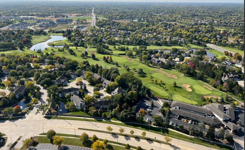
Section 9: Looking Forward
The Existing Conditions Report has identified several issues, strengths, weaknesses, and opportunities in Buffalo Grove. This information was gathered from initial meetings with the Steering Committee, key stakeholders, the general public, Village staff, and available records. The following section summarizes themes and outlines the roadmap to achieve the village's 2050 vision. These themes provide a basis for goals, actions, and strategies that will be further explored in the Comprehensive Plan.

unts, are d nodes vestment ove High presence d in and ains, and ested in
Vision for 2050
The vision for 2050 includes neotraditional planning principles: welcoming neighborhoods, walkability, open and green spaces, a mix of developments and uses, and central gathering places At the same time, the vision integrates modern and progressive principles that revolve around technology, aging-in-place, thoughtful redevelopment, adapting to market demands, infrastructure modernization and environmental sustainability. These dynamics collectively paint a picture of a community that is committed to being Smart. With Heart. so that Buffalo Grove will continue to be a leading community where families and businesses thrive


Roadmap to Achieve the Visoin Roadmap to the Vison
The following themes outline the roadmap to achieve the 2050 Vision. These themes provide a basis for goals, actions and strategies that will be further explored in in the Comprehensive Plan.
Nurture Our Assets
Buffalo Grove is an attractive and appealing community for both residents and businesses alike Its location and connections to the Chicago Region along with its key assets make it stand out as a prime community in the region. These assets include a strong housing market, excellent schools, parks and open spaces, safe neighborhoods, advanced manufacturing industrial corridors, as well as modern infrastructure. These assets should be embraced and nurtured through strong partnerships, zoning, regulations, and strategic planning
Facilitate Growth and/or Transition for Key Elements and Areas
Buffalo Grove should look to facilitate growth and transition for certain community elements and areas This includes the existing housing stock, which should be diversified to accommodate empty nesters, young professionals, and the aging population This could be facilitated both through renovation of existing homes and through new construction. At the same time, the Village should consider transitional uses for office market such as redevelopment or adaptive reuse.
Finally there are several key subareas within the Village that provide significant opportunities for growth and transition through development or redevelopment This includes the the Lake Cook Corridor, the Prairie View Metra Station Area, the Dundee Corridor, the Milwaukee Corridor and the Aptakisic Corridor.
Modernize Our Tools
Although some updates and progress has been made, the Village’s planning and development tools should be more holistically modernized This includes the zoning and building codes, appearance guidelines, and related planning tools such as PUDs and mixed use land use.
Monitor and Respond to Tech and Real Estate Market Trends
In order for the Village to fully achieve its vision, it will need to understand and respond to two elements that are always changing and evolving: technology and the real estate market Unlike other governmental entities that seemingly ignore advancements and changes in the real estate market, Buffalo Grove should seek to integrate them into their own operations and strategic planning as well as expectations for future development and growth.
