
3 minute read
Fuglafjørður Hellurnar 3


Fuglafjørður Hellurnar
A pleasant walk between the magnificent mountains of Fuglafjørður along the old village path to Hellurnar
The route begins at the football pitch at the top of the village. From the road on the west side of the football pitch is a path that goes upwards. The first part is paved. You then arrive at a gate leading to the field. Follow the path about 2-300 metres through meadow before you reach the gate to the outfield. From here, it can be difficult to see the path, but approximately 500 metres further to the right, the first cairn is visible. Above the lowest cairn is a ridge called Rossaryggur . Traces of the path are seen winding up it. Fuglafjørður is behind you and to the west, you can see Blábjørg, Jøklaskarð, Gjógvaráfjall and Niðan á Hús, where people from Fuglafjørður hid from pirates in the old days. Then comes Nón (where the sun hits at “nónbil” – at 3 p.m.), Breiðaskarð, Kambur, Trælavatnaskarð, Tyrlar and towards east Ritafjall, known as Leirvíksfjall to people from Fuglafjørður. The event Top Fuglafjørður is organised every September. It is a trip to the 10 mountains around Fuglafjørð. With its 18-20 kilometres, the trip is quite demanding, but uniquely beautiful. Further information can be found at the local information office.
The path from Fuglafjørður to Hellurnar is called Sjúrðargøta. There is a story about a giant from Suðuroy who went to Oyndafjørður to test his strength. No one dared fight him. The people from Oyndarfjørður urged Sjurður, the farmer, to challenge the giant. He wanted his youngest son, also named Sjúrdur, to try. They wrestled and Sjurður beat the giant. His father paid him well for his deed.
On the way up to Fuglafjarðarskarð you walk along Malunar Hav (Malan’s Rock). Legend tells about a milkmaid named Malan, who was pregnant and
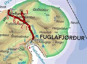
was teased by the other milkmaids for not keeping up with them. Malan picked up a 176 kg rock and challenged the others to do the same. They could not. 100 metres west of the path runs Neytakonukeldan. The milkmaid’s tankard, which people used to quench their thirst, lay here.
At the top of Skarðið, you see two large cairns. According to an old custom, each time you pass Skarðið, you throw three small stones at these cairns while saying: “In the Name of the Father, and of the Son and of the Holy Spirit”. This is meant to protect you from getting lost and to bless the trip. To the north from Skarðið, you can see the village of Oyndarfjørður and the mountains Tindur, Knúkur and Sandfelli. On the first Sunday in August, it is custom to hold a public meeting with speeches and songs on Skarðið in the open air.
From Skarðið, you can extend your walk by 40 minutes and walk up to Altarið on the top of Rustakambur. From here, there is a great view of the islands and the sea to the north.
Hulduheyggjar lies to the west when you walk down from Skarðið. Here, a Huldukona (Hidden Woman) (page 58) received help in childbirth from the midwife from Dalbøur in Fuglafjørður. The midwife received a good reward from Huldufólk (Hidden People).
Another story tells about a landownership struggle between the Oyndarfjørður farmer and Gullbrandur, a farmer in Fuglafjørður. Gullbrandur was killed and hidden in Gullbrandshellið and later buried in Gullbrandsleiði , which this path passes. Duration: Two hours (one way). 40 minutes extra up to Altarið
Distance: Six km
Difficulty: Moderate. Smooth slope up to Skarðið. It is steeper on the other side down to Hellurnar
Maximum height: 353 m (Altarið is at 483 m)
Children: The route is suitable for children, maybe with a helping hand the last stretch down to Hellurnar
Surface: Grass path and some places stones and rocks
Maps: 412 and 512
Approaching Hellur, you walk down Kliv and down Spreingisbrekka. It is a little steep, until you come to the outfield gate.
If you want to continue on a slightly longer trip, walk to Oyndarfjørður and follow the route by the old village path from Oyndarfjørður to Elduvík, which is also described in this booklet on page 18. Follow the paved road to the other side of the fjord and go into the centre of the village where the school and the shop are located.


