Mourne Mountains


The Mourne Mountains is a varied and beautiful area situated in the South East of Northern Ireland. It is a delightful blend of stunning natural beauty, traditional experiences, fascinating sites and endless ways to pass a memorable holiday. If you are looking for a day excursion or a long distance tour, the Mourne Mountains offer breathtaking scenery where rich heritage lies around every corner. Whatever your interests or age, you will find it a unique place to explore, discovering secrets and treasures for years of happy memories.
For groups looking for more energetic activities along the Mournes’ paths and bridleways, linear walks offer an ideal way to start and finish a walk at different locations. Use your pre-arranged transport to drop off and pick up, as required. For more information on suggested walks, events and coach itineraries in the Mourne Mountains visit visitmournemountains.co.uk or contact any of the Visitor Information Centres in the area.
Travelling around the Mournes by coach or minibus allows passengers to relax, unwind and enjoy the scenery of a peaceful and unspoilt environment. Whether you are planning a tour of adventure sports, walking, nature, or if your group simply wish to travel from one fine hostelry to the next – the Mourne Mountains has it all.
By travelling in a group, you are helping to reduce the numbers of vehicles and congestion on the Mournes’ roads. Please use the coach parks shown on the maps so that your vehicle does not cause access problems and congestion for local farm traffic and emergency vehicles.
This guide aims to help group organisers, tour planners and drivers to plan visits and excursions in the Mourne Mountains so that their clients get the maximum enjoyment from the area, whilst at the same time preserving the area’s special qualities.
Group organisers, tour planners and coach drivers can help to conserve the special qualities of the Mourne Mountains by following the advice given in this leaflet.
 Belfast Larne
Dublin Dun Laoghaire Holyhead Liverpool Fleetwood
troon Cairnryan stranraer
London
edinburgh Cardiff

• The scenic routes have been carefully chosen to maximise the scenic value of each and to embrace the rural nature of this part of Northern Ireland. As a result some of the roads used for the loops are minor country roads which may not be entirely suitable for some larger vehicles. Drivers and operators are advised to assess each scenic loop for suitability in an appropriate vehicle prior to using a larger vehicle and where necessary pre-plan alternative routes.
• Use the hierarchy of roads and advisory one way systems shown on the map to plan the best routes for your journey. This has been devised not only to prevent large vehicles meeting but also so that larger vehicles approach narrow bridges in the correct direction to allow them to cross with care. Note: some longer vehicles may find it impossible to cross these bridges if they approach in the wrong direction.
• Please park in designated parking areas or surfaced lay-bys only. Do not park in informal or designated passing places, or in locations which would cause problems for large vehicles.
• Avoid driving on roadside verges as these are often sensitive habitats for wild flowers and are important features in the landscape.
• Consider the use of smaller vehicles if your tour includes the narrower roads in the Mournes.
• Drive with extreme care on all roads within the Mourne Mountains; they are legitimately used by walkers and cyclists as well as vehicles. Farm animals and slow moving vehicles are also frequently encountered.
• Use lay-bys to allow traffic to pass when necessary.
• Visit Group Travel Information at visitmournemountains.co.uk for details of itineraries, accommodation and attractions.
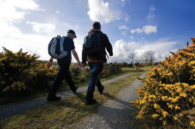
• Enjoy the countryside and respect its lifestyles, work, and customs. Support local skills, services, producers, and craftsmen.
• Wherever you go keep to public route and access areas.
• Leave all gates as you find them; open or closed.
• Use gates and stiles to cross dry stone walls, fences, and hedges.
• Avoid trampling meadow grass by walking in single file through meadows in summer.
• Protect wild animals, trees and other plants. In particular leave wild flowers for others to enjoy, and avoid disturbing birds and other animals.
• Keep your dog under control, preferably on a lead.
• Leave livestock and farm machinery alone. Beware of farmyard dangers.
• Take your litter with you.
• Guard against the risk of fire.
• Help to keep rivers, streams, and lakes clean.
• Wherever possible use public transport.
• Take special care on narrow roads.
• Park thoughtfully. Where available use official car parks and don’t park on grass verges or in passing places.
• Respect other peoples’ peace and quiet.
• Show consideration for those who use the countryside in other legitimate ways.

Kilkeel has a long, strong tradition of fishing and farming. it is the main fishing port on this coast, with one of the largest fishing fleets in northern ireland. the town is the seafood centre of the Mournes, and the ancient capital of the Kingdom of Mourne.
The Nautilus Centre is the first point of call for visitors, with its panoramic views of the harbour. The centre houses the Visitor Information Centre, Mourne Maritime Visitor Centre and Mourne Seafood
Cookery School. There is a new exhibition about tracing your roots in the Mournes, as well as a gift shop. The town’s walking/ heritage trail starts here. The Big Fish sculpture is a popular backdrop for visitors’ souvenir photographs.
Near the centre, the Seafarers’ Memorial is a monument to fishermen who lost their lives at sea. Mourne granite is now protected, so this is one of the last large pieces to be quarried in the area. The Kilkeel company that created the monument also made the Diana Memorial Fountain in London’s Hyde Park.
Award-winning Cranfield Beach is just outside the town, at the mouth of Carlingford Lough. The long, south-facing beach has excellent facilities (play park, nearby café and toilets) and the warmest waters in Northern Ireland!
The famous Percy French song, the Mountains of Mourne, was written when French stayed at the Temperance Hotel in Kilkeel.
Ask for advice in the Visitor Information Centre –Kilkeel has a range of local independent shops, as well as cafes, takeaways, and pubs
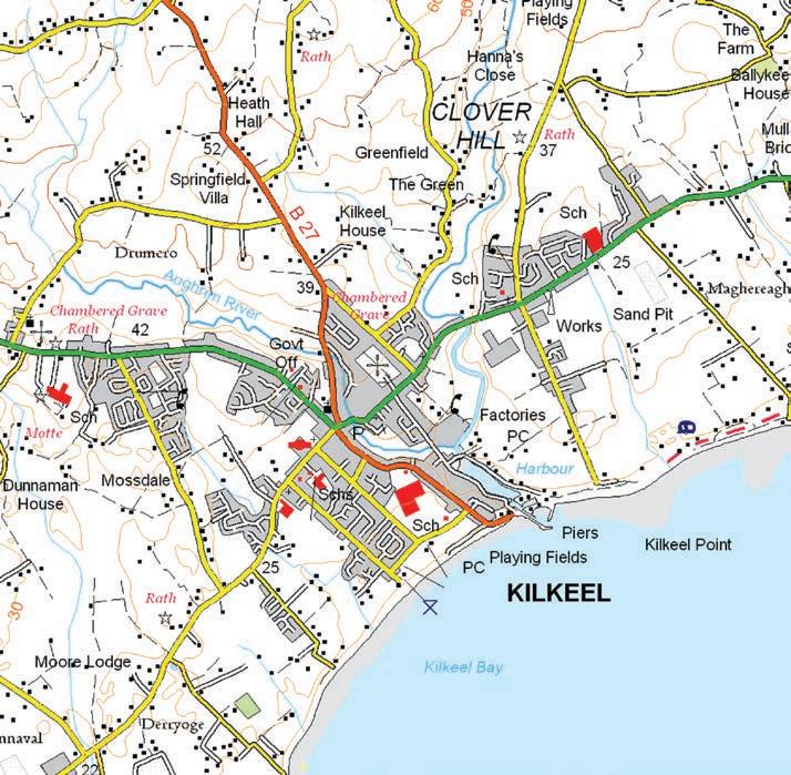
serving food. There are also a few restaurants in the town. The town’s heritage trail map (pick one up in the Visitor Information Centre) shows all the local services.
Public toilets in Nautilus Centre, Greencastle Street, Lower Square and Cranfield Beach.
Free parking behind the Nautilus Centre, on Mourne Esplanade near the play park and leisure centre, and several car parks in the town centre around Newry, Greencastle and Newcastle Streets.
Viewpoint
Shopping Public Toilets
Visitor Information Centre Coach Parking Coach Washing
newcastle is set in a stunning location on the irish sea and at the base of slieve Donard, the highest of the Mourne Mountains’ peaks. this seaside town has lots to do for all the family, with many activities nearby and an award winning promenade for walkers. the town is also famous for one of the world’s most celebrated links courses –royal County Down Golf Club, situated beside the luxurious slieve Donard resort and spa.
Murlough National Nature Reserve, stretching from Dundrum to Newcastle, borders one of Ireland’s most popular beaches. It’s perfect for walking and spotting wildlife – the network of boardwalks leads you through the reserve.

Tollymore Forest Park is one of Northern Ireland’s largest and most attractive forests, with walks along the scenic Shimna River.
Professional golfers regularly name Royal County Down as one of the world’s top golf courses. This links course runs
along Dundrum Bay beside the nature reserve, with stunning views of the Mourne Mountains.
The B/E Aerospace Festival of Flight takes place in Newcastle annually over a week in August, with many free events for all the family, including a programme of air displays with amazing jet aircrafts.
shopping & eating Newcastle Visitor Information Centre sells a range of traditional and contemporary crafts and local souvenirs for visitors. The centre can also advise on local listings for
places to eat, and where to shop in the town’s many independent boutiques. Newcastle is full of places to eat, catering for all tastes and budgets, and within walking distance of the town centre.
Public toilets are located next door to the Visitor Information Centre, Donard Park, Murlough Nature Reserve and Tollymore Forest Park.
Large public car parks on the Shimna Road, Donard Park, Murlough Nature Reserve and Tollymore Forest Park.
Viewpoint
Shopping Public Toilets
Visitor Information Centre
Coach Washing for Small Coaches
Coach Parking Free Wifi Available Golf Course
Warrenpoint lies on the shores of Carlingford Lough. the town was built on a grid system, with its square (one of the largest in ireland) at the centre. in the 1800s, Warrenpoint was one of the largest ports in the country and thousands of emigrants left ireland from here. it was also a fashionable seaside resort, with a stunning backdrop of the Cooley Mountains.
Narrow Water Tower House was built in the 1560s. Hugh de Lacy, first Earl of Ulster, built a keep on the site in 1212, to prevent attacks on Newry by river.
Across the road is a stately home – Narrow Water Castle – completed in 1836 in the Elizabethan Revival style and built of Mourne granite. Narrow Water is still a family home and popular wedding venue.
The statue of a giant elk near Narrow Water shows an animal that is now extinct,
but used to roam the local countryside.
The Town Hall has a theatre and exhibition space and houses the Visitor Information Centre. Warrenpoint Park has a play area, stunning flowers and greenery, as well as popular concerts in the summer in the Edwardian bandstand.
The Magennis Coronation Stone stands at Bridal Loanan, and is the stone of destiny of the Magennis clan. The clan’s chieftain was inaugurated by putting his foot and staff of power into slots in the stone.
Warrenpoint has a great reputation as a hub for eating out and festivals. The Visitor Information Centre can help you with local listings. A stroll through the town will lead you to the many cafes, bistros, pubs and restaurants.
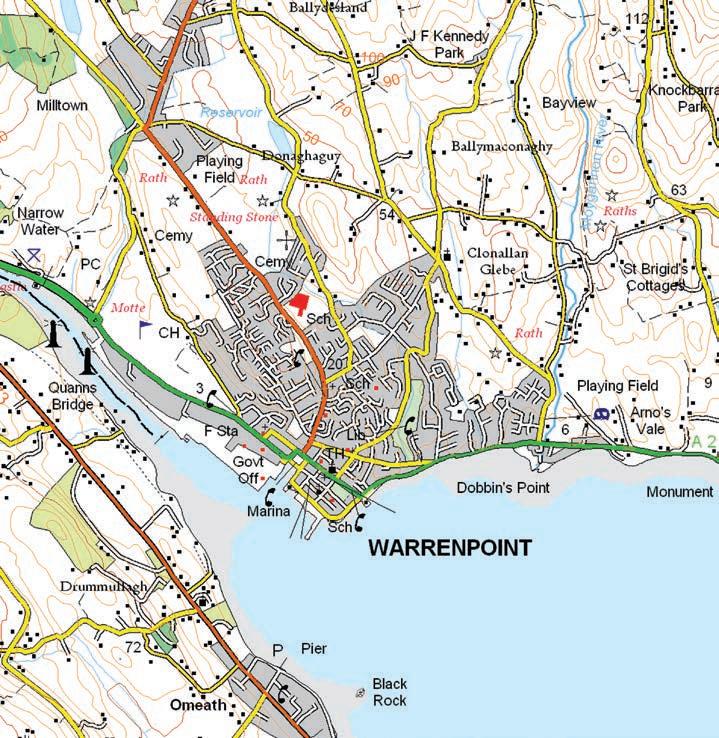
Toilets at the Town Hall, the park in Queen Street and the Square.
Free parking in The Square (Dock Street) and East Street.
Visitor Attraction
Viewpoint
Shopping Public Toilets
Visitor Information Centre
Coach Parking Coach Washing
newry is the main city on the Belfast to Dublin corridor, sitting on the border between Down and armagh. the river Clanrye, running through the city, forms the county border.
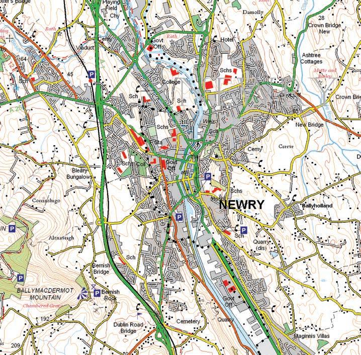
With a reputation as one of the best shopping areas in northern ireland, newry also has an ancient historical and cultural heritage.
Bagenal’s Castle is Newry’s oldest surviving building, built in the 16th Century and is part of the city’s heritage trail.
Newry Visitor Information Centre and Newry Museum
is here, as is the start of the city’s heritage trail. The centre has a craft and souvenir shop. The free museum features farming, fishing and folklore, history of the Gap of the North and robes of the order of Saint Patrick.
Newry Town Hall is on Bank Parade, and was built in the Classical style in 1893. The rivalry between Down and Armagh dictated its location on the county boundary of the Clanrye River. On the nearby bridge is a 19th Century Russian canon, given to recognise the Newry men who fought in the Crimean War.
The Albert Basin, in the canal
harbour, is in the heart of the shopping area. It has places to eat, a wildlife sanctuary and historic buildings.
The cathedral of Saint Patrick and Saint Colman is the most impressive building on Hill Street, built in local granite in 1829. It was the first cathedral opened after Catholic emancipation. Saint Patrick’s Church of Ireland was the first Protestant church built in Ireland after the Reformation. Dean Jonathan Swift (author of Gulliver’s Travels) preached here.
shopping
Both shopping centres (Buttercrane and The Quays) have the big high street
names. There is a good mix of independent boutiques in Hill and Monaghan Streets.
eating
Great choice of places to eat, from restaurants to takeaways – the Visitor Information Centre can help you choose.
Public toilets at the Visitor Information Centre/Newry Museum at Bagenal’s Castle, Town Hall, Newry Market and shopping centres.
Parking
Around 15 car parks in the city centre, including large number of spaces at the two shopping centres.
Visitor Attraction Viewpoint Shopping Public Toilets
The Slieve Roosley landscape could be described as the ‘hidden Mournes’ and has formed part of the inspiration for author C.S. Lewis, who spent boyhood holidays in Rostrevor, in his creation of the magical world of Narnia. It is an open landscape of windswept hilltops, more intimate valleys and foothills, interspersed with small villages and, along the glens, a mixture of homesteads and farms. Rostrevor oak wood
is one of the few remaining native oak woodlands in Ireland and, along with the more recently planted Rostrevor and Yellow Water forests, offers peaceful walks. Leitrim Lodge and Hen Mountain amenity areas are both beautiful sites for a riverside picnic.
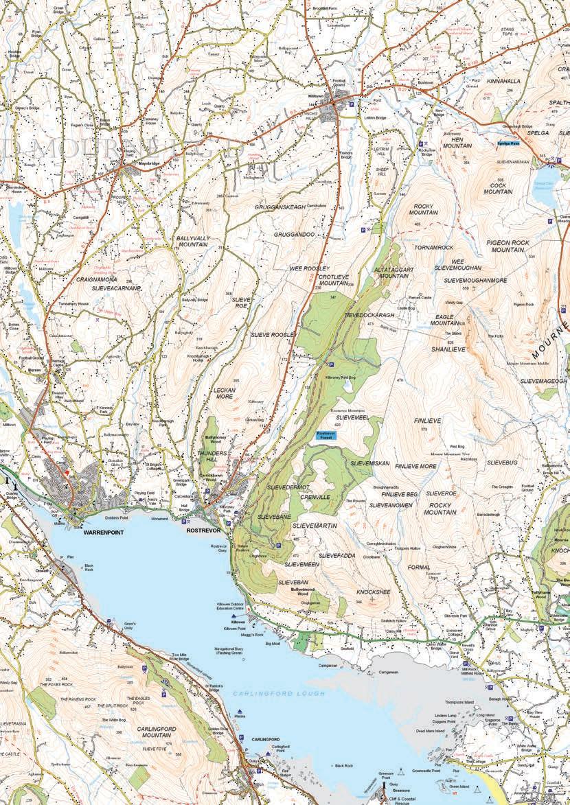
Hen Mountain is one of the smallest of the Mourne Mountains but its summit, with its distinctive granite tors, presents an almost
lunar landscape popular with rock climbers as well as walkers. Nearby Hilltown was the reputed destination of many of the 18th and 19th century smugglers who were said to have shared out their contraband here, having transported it across the mountains on ponies from the coast near Newcastle, via the ‘Brandy Pad’. It remains a good place for refreshment – now entirely legal of course!
Coyle’s Hill at the top of the Yellow River above Hilltown offers a truly spectacular view over Slieve Roosley and the high Mournes.
*drivers are advised to assess each scenic loop for suitability in an appropriate vehicle prior to using a large vehicle.
Coach Parking there are height restriction barriers in the picnic areas (Yellow Water, leitrim) but they could be opened if requested in advance. Contact the Newry Visitor Information Centre for more details.
scale 24mm : 1km n s
You are advised to start your journey at the Kilkeel end of the loop.
This route is named after the Whitewater River which flows from the lower slopes of the Mourne Mountains to the sea at Mill Bay on the main Mourne Coastal Route. As well as a site of world conservation importance for its sea birds, the latter is a location from which the first farmers in this area harvested seaweed to improve the thin acidic soils and produce the now productive farms that you see as you drive the route.
start
1km 2km 0 3km approx Drive time: 20 minutes (14km) W
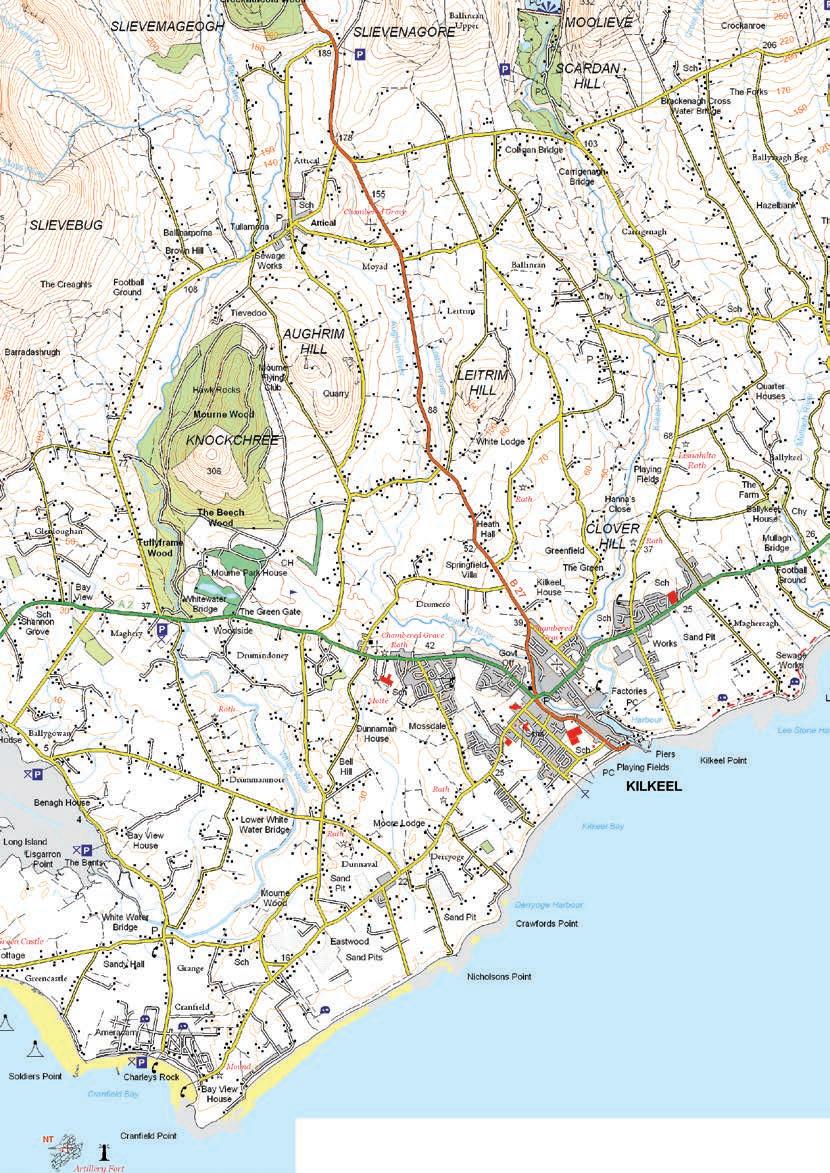
Attical is the highest village in the Mourne Mountains; a true mountain home where visitors are catered for in the community run hostel, “The Mourne Lodge”. Travelling the loop affords wonderful views of Slieve Binnian, one of the most distinctive of all the Mourne Mountains.
In Binnian’s shadow is the Silent Valley Mountain Park containing forest, riverside and mountain walks, an adventure play area and a visitor centre telling the story of the building of the dams. This massive engineering
project began in 1923 and included the construction of a temporary town, called Watertown, to house the workers and provide them with a hospital, a cinema and even their own policeman. Another feature of this loop is the opportunity to see up close the distinctive dry stone walls of the Mourne Plain built with granite boulders rounded by the ice sheets of the last glaciation. The large gaps between the stones can make the structures look precarious and cause some to wonder how these structures
stay up. But these gaps are actually a point of strength, allowing the often strong sea breezes to pass through, and also a thing of beauty when the early morning or late evening sun glints through. Are they works of engineering or art?
e Key
Visitor Attraction Viewpoint
Visitor Information Centre
Coach Parking Coach Washing Suitable for all sizes of vehicles
Not suitable for larger vehicles Finish
You are advised to start your journey at the newcastle end of the loop.
This loop delves into the very heart of the famous Mourne Mountains offering iconic views of Slieve Commedagh, Bernagh, Meelmore, Meelbeg and beyond. Below the summits, the charming village of Bryansford and Tollymore Forest Park are well worth a stop for walks along the Shimna River and among the wonderfully ornate and quirky stone bridges, gates and follies of this planted demesne. If you are lucky
you might catch a glimpse of a Red Squirrel or two. Where forest gives way to open heathland, Trassey Track leading to Hare’s Gap is one of the main walking access routes to the high Mournes. At Spelga Dam you are at the ‘junction’ of the Eastern and Western Mournes where people brought cattle for summer grazing on the high pastures of the Deer’s Meadow, living in turf built ‘booley huts’ for those months. The River Bann sets off from here on its journey to Lough Neagh
and beyond. The Silent Valley Mountain Park is home to two more reservoirs set against a stunning backdrop and offering amenities and a wealth of history to explore. Among the many feats of early engineering and human endeavour, look out for the cut granite Mourne Wall as it winds its way over the twelve highest peaks, seeming at times to defy gravity. Where this loop meets the Mourne Plain, Carrick Little provides access to the beautiful Annalong Valley and is also a perfect vantage point to
see the ‘patchwork quilt’ effect of the small fields bounded by dry stone walls, built as the hardy locals cleared the rocky ground to make their farms. Look also to the horizon where, in clear conditions, you can see the twin mountain peaks of the Isle of Man and, on occasion, the hills of Cumbria beyond.
*drivers are advised to assess each scenic loop for suitability in an appropriate vehicle prior to using a large vehicle.

You are advised to start your journey at the Castlewellan end of the loop.
The Slieve Croob scenic loop explores a truly ancient landscape, much older than the high Mournes. The craggy peaks and rolling valleys were formed when an ancient ocean closed about 400 million years ago. The legacy of man’s interaction with the landscape across millennia is very visible here.
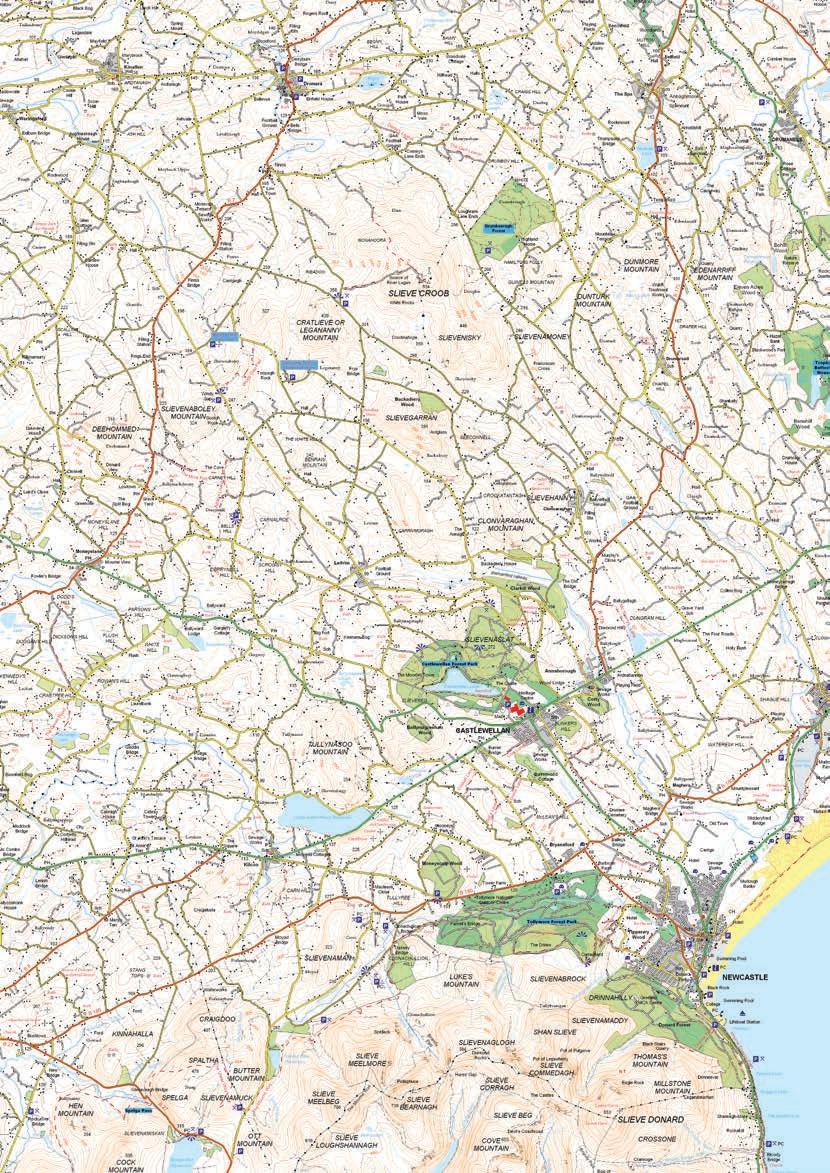
Legannany Dolmen is one of the most striking Bronze Age portal tombs in Ireland, with a huge granite capstone supported by three upright rocks. Nearby Binder’s Cove souterrain is an underground passage probably used for storage or shelter in times of strife. At Windy Gap the remnants of ‘lazy beds’, raised ridges used for the growing of potatoes in the times before the Great Famine, can be seen. The Slieve Croob
area also provides some of the best panoramic views to the Mourne Mountains, while sites like Windy Gap also offer views south to the Cooley Mountains in County Louth and the Ring of Gullion in County Armagh. And as if that is not enough, a walk from Dree Hill car park to the summit of Slieve Croob, which can be navigated via a paved road, will be rewarded on a clear day with vistas over the Lecale Coast and Ards
Peninsula to the Belfast Hills and the huge yellow cranes of Belfast Harbour. Did you know that the River Lagan, which flows to the sea at Titanic’s birthplace begins its journey on these very slopes?
*drivers are advised to assess each scenic loop for suitability in an appropriate vehicle prior to using a large vehicle.
