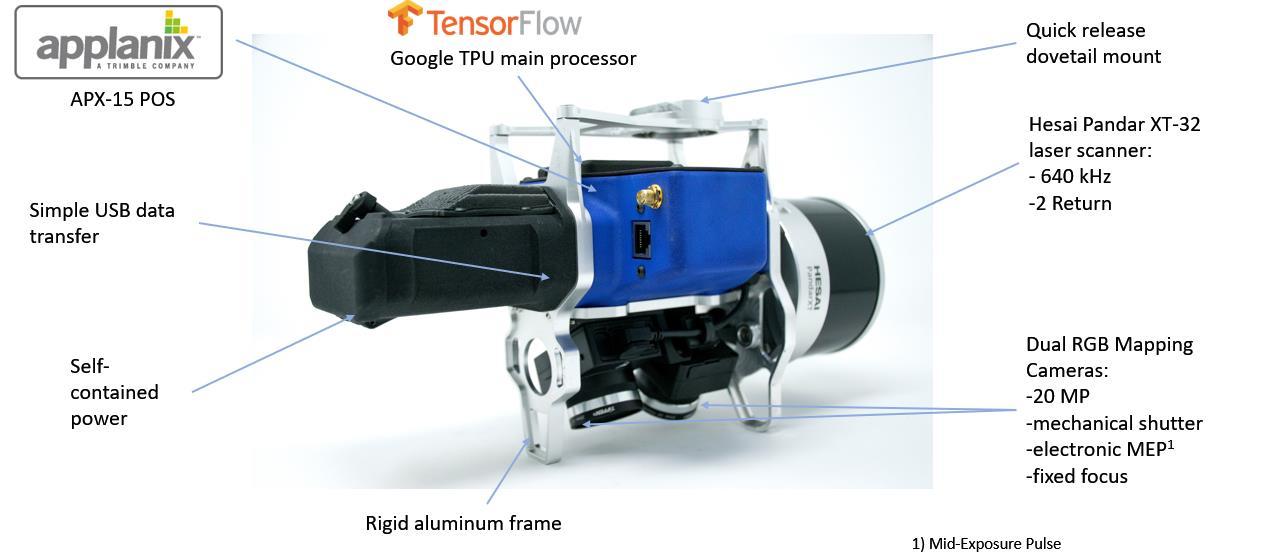
3D Imaging Sensor vs. Traditional LIDAR/Camera Combinations 1. What is a 3D imaging Sensor (3DIS)? A 3D Imaging Sensor (3DIS) is a definition coined by us (GeoCue Group Inc.) Basically, it is a system of hardware and software that can generate a true 3D colorized point cloud. A general 3DIS derives geometric information (X, Y, Z, time) and some target characteristic information (infrared reflectance, for example) from a laser scanner (or radar) and radiometric information from calibrated, synchronized photogrammetric cameras. The laser (or radar) points are “painted” from the synchronized images using a 7 degree of freedom (7 DOF – X, Y, Z, Pitch, Yaw, Roll, Time) ray tracing algorithm. The camera(s) must be synchronized to the Position and Orientation System POS) such that the full orientation for each image frame can be computed. This means the system must be encoding time-synchronized camera pitch, yaw and roll in addition to the X, Y, Z location of the camera focal point. These data tuples are called the full, time synchronized Exterior Orientation (EO) of the camera. Post-processing software must include ray tracing algorithms that trace each 3D LIDAR (or radar) point back to the appropriate source image (not a derived image such as an orthophoto). This process requires both the aforementioned camera EO as well as precise camera calibration.
2. What is the advantage of the 3D Imaging Sensor compared to a standard LIDAR system? Data from a standard LIDAR system can be used to generate a 3D monochromatic point cloud. Attributes of the point cloud typically include: • X, Y, Z position in an exploitation spatial reference system (SRS) • High resolution GPS time of pulse • Intensity of the laser return • Return number (if your LIDAR is multiple return capable) • Scan angle (angle of the beam relative to nadir when this point was detected) • Flight line (swath) ID Note that no color (or, in general, radiometric) information is contained in the above information. A 3D imaging sensor (3DIS) includes both a laser scanner and one or more GeoCue Group, Inc. 9668 Madison Blvd., Suite 202 Madison, AL 35758
Page 5 of 29
256-461-8289 (voice) 256-461-8249 (FAX) www.geocue.com