39 minute read
Prototype Sites
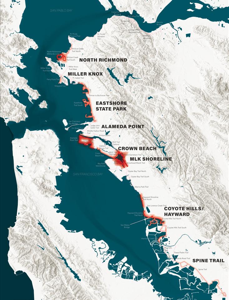
EIGHT PRIORITY BAY TRAIL SITES
See more details about the risk assessment and prioritization process in Chapter 2: What is at risk?.
From Eight Priority Sites to Three Prototypes
Three Bay Trail sites were selected after the risk assessment to demonstrate the potential pathways for shoreline adaptation in more detail. Those include Alameda Point, McLaughlin Eastshore State Park, and Martin Luther King Jr. Regional Shoreline.
This chapter illustrates a localized approach to nature-based adaptation solutions in areas that are at risk of sea level rise inundation in both the mid-century and end-of-century planning scenarios. In addition to the adaptation approach, each site also identifies next steps for continued conversations with stakeholders and the broader community.
Several of the areas identified as priority sites in the risk assessment within the study area are undergoing parallel planning efforts. Those include the Hayward Shoreline Master Plan effort led by HASPA, and North Richmond planning efforts. While this report fully supports the prioritization of those areas, they were not explored in more detail in this chapter.
Alameda Point
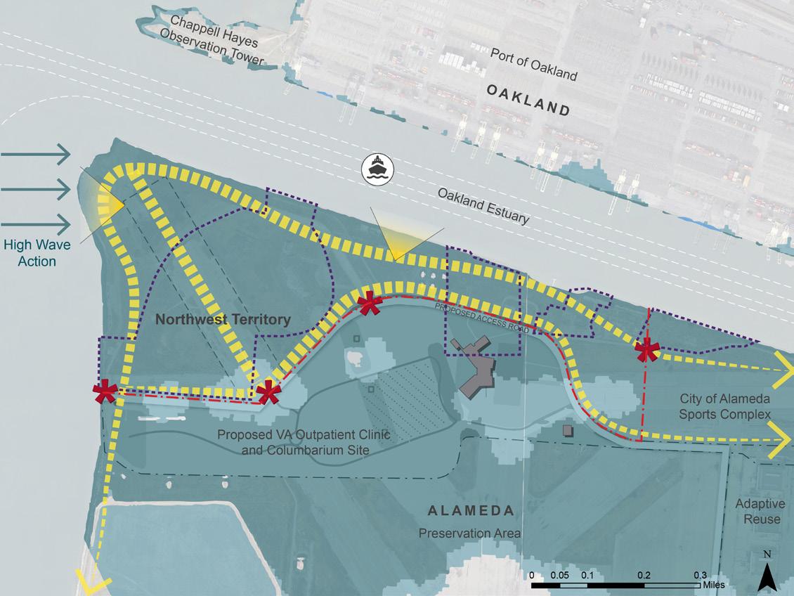
Alameda Point and more specifically, the Northwest Territory, is at risk in both the mid- and end-of-century planning scenarios explored in this study. The site is in the process of being planned as a new regional park with a Bay Trail extension to be managed by the Park District and is part of a larger master plan coordinating contamination mitigation, and ongoing planning processes with the Park District’s partners, including the City of Alameda, the US Navy, and the US Department of Veterans Affairs (VA). The recommended adaptation approaches vary based on the longterm decisions related to site cleanup, but both examples show the potential for the Bay Trail and the new regional park to adapt through the end-of century.
FIGURE 4-1: ALAMEDA POINT
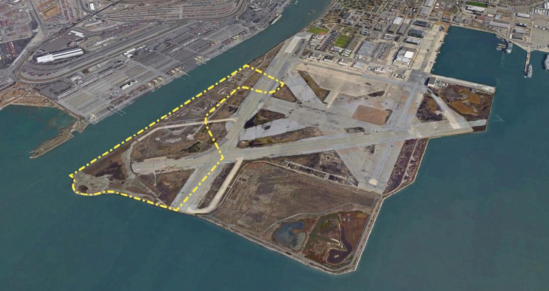

FIGURE 4-2: McLAUGHLIN EASTSHORE STATE PARK
McLaughlin Eastshore State Park
The Bay Trail segments along McLaughlin Eastshore State Park are managed by several different groups in addition to the Park District, including the City of Berkeley, Caltrans, and CA State Parks. While the main branch of the trail adjacent to the frontage road is not at high-risk within the park, the lengths of the Bay Trail that connect to César Chávez Park and the sensitive habitats within the Berkeley Meadow will see major changes in tidal inundation in the mid- and end-of-century planning scenarios. This adaptation example highlights the opportunities associated with planning for a longterm trail alignment and habitat migration and demonstrates use of coarse-grained beaches as an alternative to rip-rap along the East Bay shoreline.
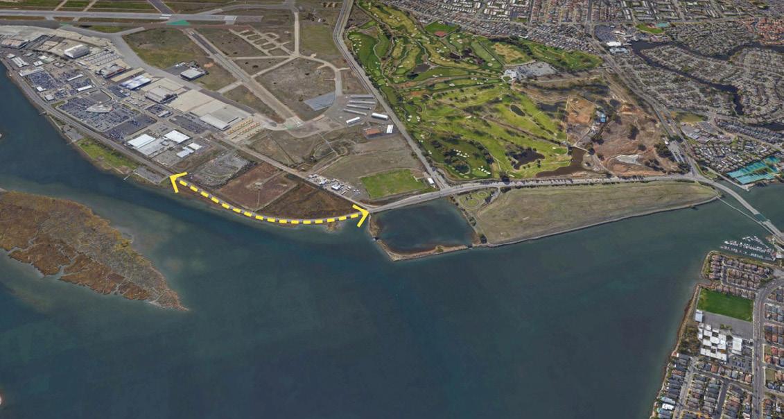
FIGURE 4-3: MARTIN LUTHER KING JR. REGIONAL SHORELINE
Martin Luther King Jr. Regional Shoreline
Finally, the Martin Luther King Jr. Regional Shoreline, specifically the Doolittle Drive segment along the south side of the San Leandro Estuary, was identified as an ongoing challenge for adaptation planning. Due to the high ecological value of Arrowhead Marsh and the adjacent shoreline areas around the estuary, the Park District has been challenged when considering potential trail elevation near these areas. Adaptation of the San Leandro Estuary will require integrated coordination across partners including Caltrans, City of Oakland, City of Alameda, and others. This guidance focuses on potential options for developing these partnerships which will be key to any future adaptation planning.

Planning Context and Key Stakeholders
The decommissioning of the Naval Air Station in Alameda created the opportunity for new uses to serve the city and region. Planning efforts for the site have included a vision which includes open space, trails, a veteran’s clinic and columbarium, in addition to mixed-use housing and commercial neighborhoods along the eastern edge. Many stakeholders are involved in the planning process, including the US Navy, the US Department of Veteran Affairs (VA), and the Park District. As part of the transition of the land to local control, the US Navy has an important responsibility to ensure that the site is safe and that any contamination on the site is remediated.
The vision proposes a regional park in the northwest corner, referred to as the Northwest Territory, and includes a Bay Trail connection around the full extent of the point. The Park District has been a partner in establishing the new public land for the regional park and Bay Trail in the Northwest Territory and developing and managing the park in the future.
Due to its low-lying elevation, it is critical to understand the impacts of climate change and sea level rise on the site. In recent years, some of the impacts of climate change and sea level rise have been incorporated into high-level guiding documents for the Naval Air Station Base Reuse Plan, e.g. in the Master Infrastructure Plan and its Amendment. However, the coordination of coastal protection and sea level rise adaptation planning for Alameda Point is still in early stages. The design of the Northwest Territory and Bay Trail will need to address unique site conditions that are unlike other areas on the island.
As part of this study, the design team and Park District organized stakeholder meetings with City of Alameda staff to discuss future park
design coordination efforts with all partners, including the US Navy and the VA.
First, the Park District and City of Alameda determined the need to coordinate with the VA specifically regarding their approach to sea level rise impacts in the area. Questions regarding the planned elevations for buildings and the access road were documented as potential areas for collaboration with the Park District.
Second, this conversation indicated that the contamination clean-up efforts managed by the US Navy as part of the transition of the property to the City of Alameda may not adequately address the impacts of sea level rise and may require extensive actions in the future to meet mitigation goals. The current lack of removal of existing contaminated soil establishes major constraints on the conceptual design including the creation of habitat and use of adaptive shoreline treatments that protect the area as sea levels rise through the next century.
In addition to coastal protection and inundation risks, groundwater emergence caused by sea level rise can cause unforeseen movement of buried and capped contaminants. Groundwater studies are ongoing in Alameda and may reveal that the approach to mitigating contamination in these areas may need to be more robust than originally planned.
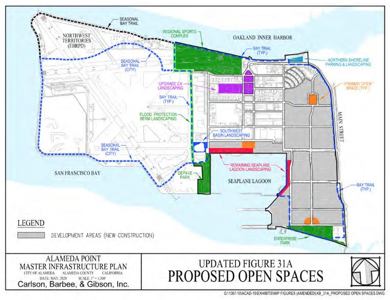
FIGURE 4-4: ALAMEDA POINT PROPOSED OPEN SPACES
Source: Master Infrastructure Plan Amendment, August 2020
Two Design Options
To both address the constraints of contamination and to advance multibenefit approaches to long term resiliency, two distinct approaches for the design of the regional park and Bay Trail alignment are proposed.
The first approach illustrates the potential for more extensive marsh habitat areas that could provide ecosystem benefits including coastal protection to the park and adjacent areas. This scheme relies on a more robust remediation of contaminated areas.
The second approach illustrates the more constrained marsh area and park amenities that would be limited if remediation of contaminants remainsas as proposed in the Record of Decision documents released by the US Navy. This also assumes that the shoreline protection designed to contain the contaminants on the site would be reinforced in place and monitored throughout the next century.
Opportunities & Constraints
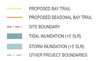
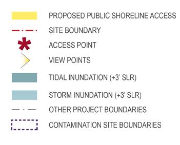
Based on existing elevations, the following maps show the extent of tidal and storm inundation across the site at mid-century and end-of century. The maps also show the locations of the cleanup areas being managed by the US Navy, and the proposed plans for the clinic and columbarium developed by the VA.
The Bay Trail extension around the point, with connections to the future City of Alameda Sports Complex and the future preservation area, are indicated below. Additional access points to the regional park along the proposed access road are also indicated.
FIGURE 4-5: ALAMEDA POINT MID CENTURY - 3FT SLR
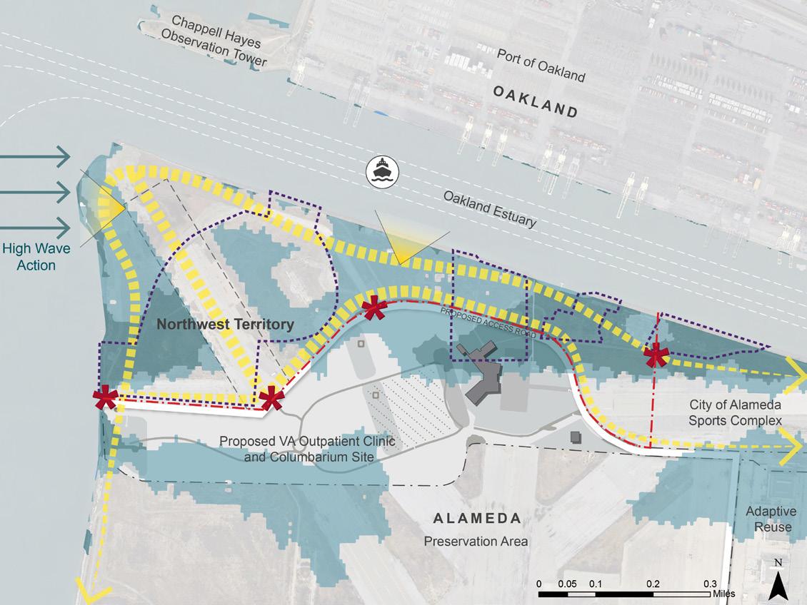
Key Considerations
• Views across the Bay towards
San Francisco and across the estuary to the Port of Oakland • High wave action from wind and
Port activity along the point and the estuary • Low elevations and inundation are risks to existing structures, but can be planned as a benefit for marsh and habitat creation
• Bay Trail segments along the shoreline could be designed to have seasonal access, if the access road remains accessible and resilient year-round and through century's end • Contamination sites must be monitored and maintained unless contaminants are removed
FIGURE 4-6: ALAMEDA POINT END OF CENTURY - 6FT SLR


OPTION 1 FULL POTENTIAL
FORTIFIED EDGE
PERCHED BEACH WITH ROCK TOE TIDAL MARSH

1
The conceptual design of the Northwest Territory in Option 1 proposes creation of significant wetland habitat to bring regionally and locally significant ecosystem benefits. Over a hundred acres of tidal marsh is created. The plan supports a range of ecological diversity from coastal uplands and dunes to tidal marshes and beaches that will provide important regional connectivity for species around the Bay Area. Nature-based adaptation strategies including ecotone slopes and coarse beaches provide buffer for erosion and address future sea level rise impacts. The western edge of the site requires special treatments to protect the site from high wind and wave impacts. The shoreline must resist forces of erosion as sea level rises to provide defense of the inland areas of soil contamination, wetlands, and public use areas. The coarse beach is a nature-based adaptation strategy that will shift with sea level rise. The shoreline at the Point will continue to require hardened armoring and is proposed to be build higher.
In addition to the robust habitat benefits and shoreline protection benefits, the concept plan offers public access to visitors throughout the end of century. The following figures illustrate the extent of inundation at mid-century and end-of-century. Note that this option assumes building the site and adjacent roads higher than water levels at end of century.
FIGURE 4-7: ALAMEDA POINT CONCEPT PLAN OPTION 1

OPTION 1 FULL POTENTIAL

FIGURE 4-8: ALAMEDA POINT CONCEPT PLAN OPTION 1 MID CENTURY - 3FT SLR


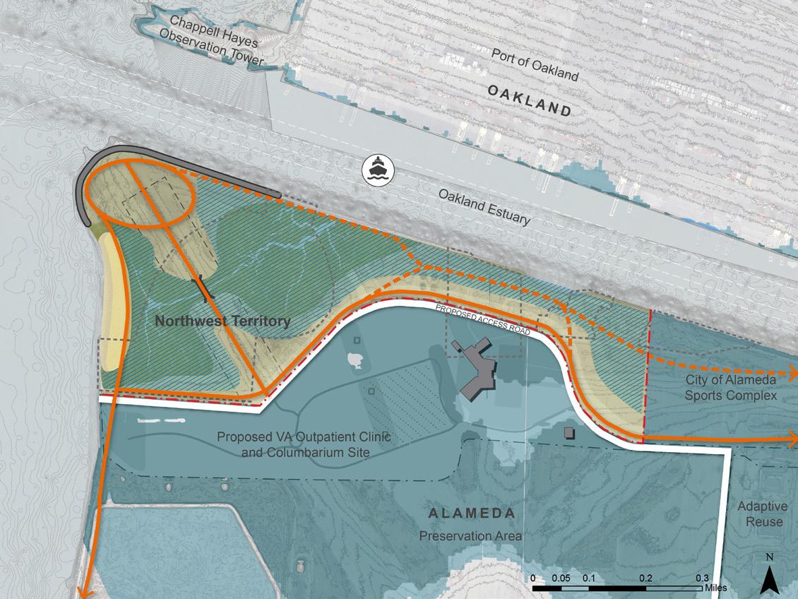
FIGURE 4-9: ALAMEDA POINT CONCEPT PLAN OPTION 1 END OF CENTURY - 6FT SLR

OPTION 1 FULL POTENTIAL
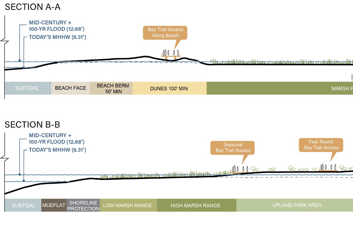

FIGURE 4-10: ALAMEDA POINT CONCEPT PLAN OPTION 1
Cross Sections and Key Plan
Alameda Point Shoreline Conditions Option 1
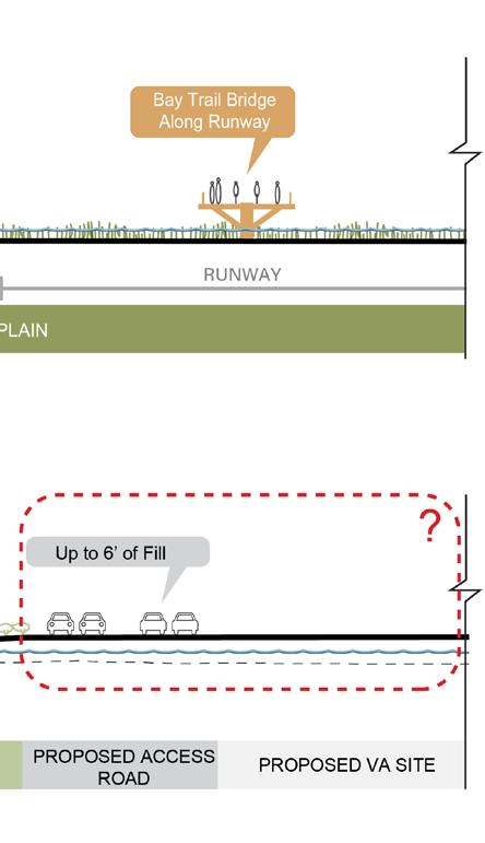
Conceptual cross-sections show how shoreline treatments protect inland areas. Section A-A from the western beach to the runway illustrates the extensive coarse beach and dune system that offers greatest resiliency and habitat value. If contamination is removed as proposed in this concept, a back bay and marsh system can be established, hydraulically connecting the beach zone to the estuary marsh. Public access is built up on a boardwalk through the dunes. The runway path is shown as a bridge for the section crossing the new tidal channel.
Section B-B from the estuary channel to the road illustrates the gradual transition of the ecotone slope. Extensive areas of low and high tidal marsh allow migration of habitats as sea level rises. The shoreline trail is seasonal or built on floats. The road proposed by the VA is raised above end of century flood levels to protect the clinic site beyond. The full width Bay Trail is combined with the road levee to ensure public access.
OPTION 2 LIMITED POTENTIAL
FORTIFIED EDGE
PERCHED BEACH WITH ROCK TOE WAVE BARRIER
TIDAL MARSH

2
The conceptual design of the Northwest Territory in Option 2 works within the known design parameters set by soil contamination clean up and the VA clinic development. The concept proposes creation of a modest wetland habitat along the estuary. Up to sixteen acres of tidal marsh is created in areas without known soil contamination. The plan supports ecological diversity from coastal uplands and dunes to tidal marshes and beaches. The limited wetland area requires additional research to evaluate its regional benefit for species migration and connectivity. Nature-based adaptation strategies including ecotone slopes and coarse beaches provide buffer for erosion and address future sea level rise impacts. The western edge of the site requires special treatments to protect the site from high wind and wave impacts. The shoreline must resist forces of erosion as sea level rises to provide defense of the inland areas of soil contamination, wetlands, and public use areas. The coarse beach is a nature-based adaptation strategy that will shift with sea level rise. The shoreline at the Point will continue to require hardened armoring. This concept leaves the ground elevations as proposed by the US Navy. Therefore inundation is expected by end of century compromising the site integrity including capped soIl contamination, wetlands, and public access.
The following figures illustrate the extent of inundation at mid-century and end-of-century. The mid-century condition shows a majority of the park and public access intact. Note again, however, that this option reflects current knowns and unknowns in the planning by the US Navy, City of Alameda, and the VA. As shown, the entire site, the road, and the VA clinic are flooded by end of century.
FIGURE 4-11: ALAMEDA POINT CONCEPT PLAN OPTION 2


OPTION 2 LIMITED POTENTIAL
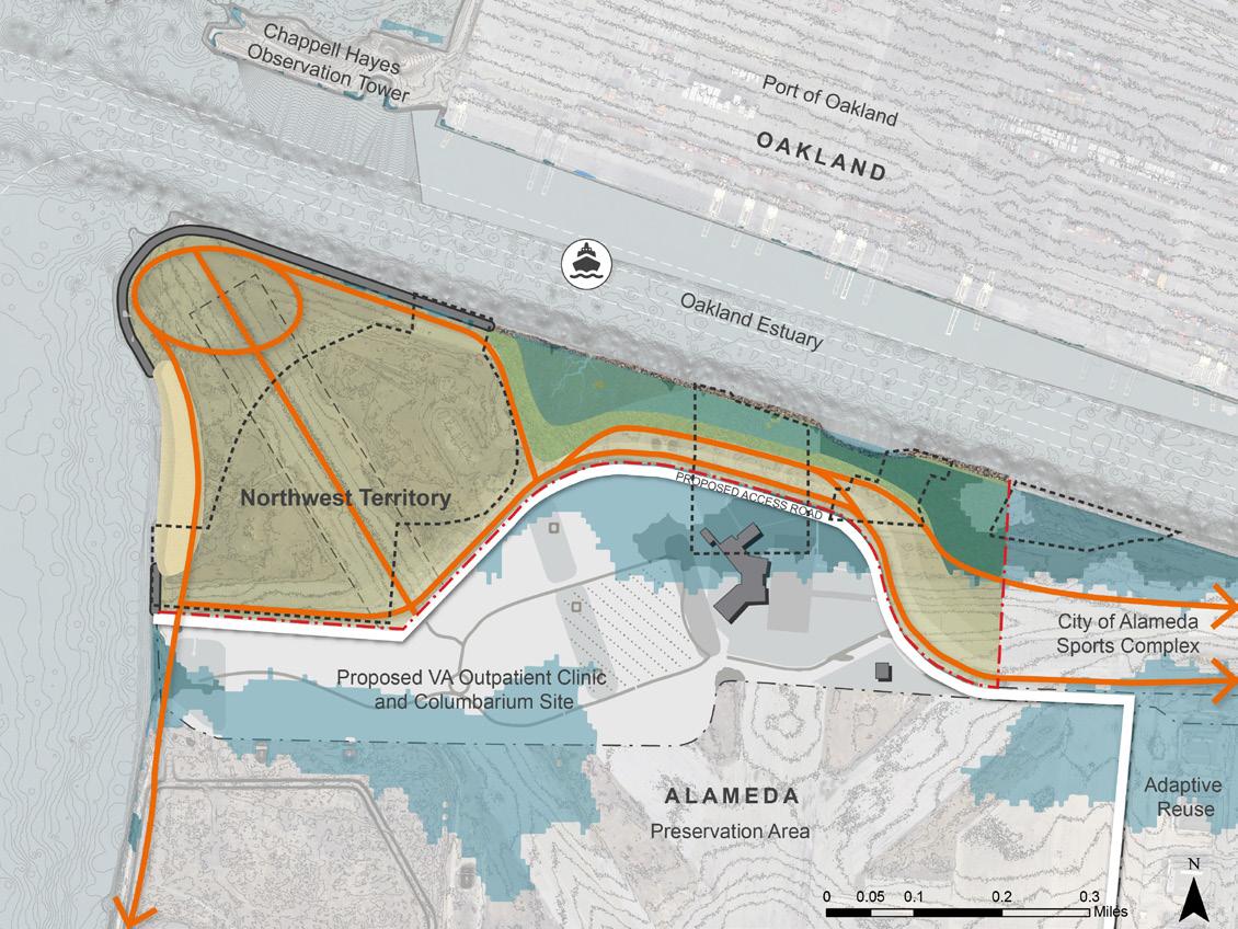
FIGURE 4-12: ALAMEDA POINT CONCEPT PLAN OPTION 2
Mid-Century - 3ft SLR


FIGURE 4-13: ALAMEDA POINT CONCEPT PLAN OPTION 2
End of Century - 6ft SLR


OPTION 2 LIMITED POTENTIAL
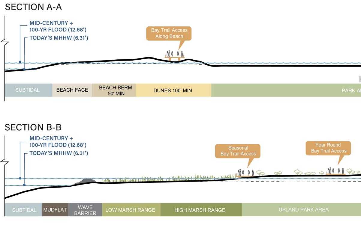

FIGURE 4-14: ALAMEDA POINT CONCEPT PLAN OPTION 2
Cross Sections and Key Plan
Alameda Point Shoreline Conditions Option 2
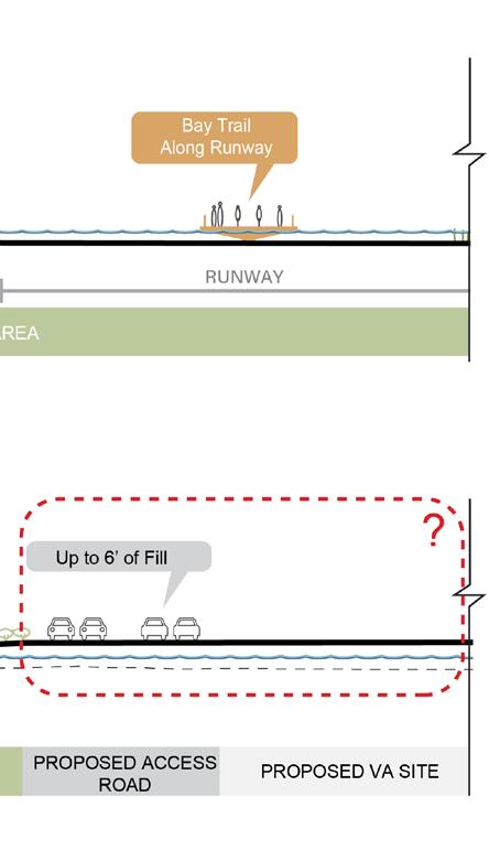
Conceptual cross-sections show how areas of the site are resilient through mid-century while total flooding occurs by end-of-century if elevations are not raised. Section AA from the western beach to the runway, illustrates the extensive coarse beach and dune system that offers greatest resiliency and habitat value. The inland capped areas of the park are relatively flat and offer upland habitat until flooding occurs. Public access is built up on a boardwalk through the dunes. The runway path is shown as an elevated embankment or raised boardwalk to allow public access for a longer planning horizon.
Section BB from the estuary channel to the road illustrates the gradual transition of the ecotone slope to the existing grades of the inland areas. Some migration of habitat is afforded until the mid-century. at some point before end of century, the entire site floods including the road, the Bay Trail and the VA site.
UPLAND PARK AREA PERCHED BEACH WITH ROCK TOE
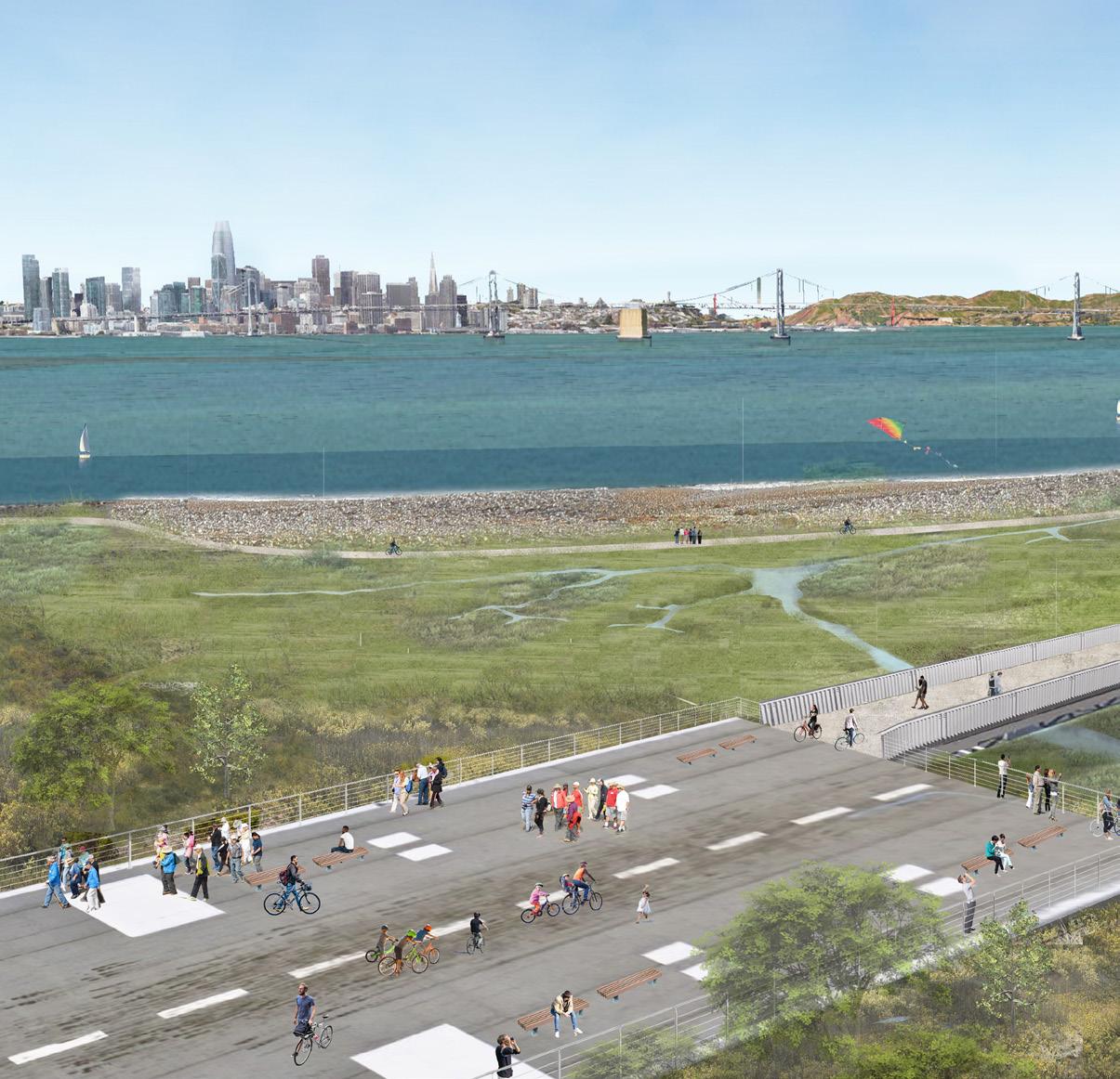
FIGURE 4-15: ALAMEDA POINT CONCEPT PLAN OPTION 1 RENDERING
UPLAND PARK AREA
TIDAL MARSH

Alameda Point Funding and Partnership Strategy
This section provides an initial strategy for seeking funding for Alameda Point that applies to both concept plan options. It identifies the elements of the concept plans that the Park District can highlight when seeking funding, the partners with whom the Park District can engage, and steps the Park District can take in the short term to set itself up for future funding opportunities.
Site Features That Present Opportunities For Funding
The Alameda Point Northwest Territories (NW Territories) concept plan provides several benefits that could serve as the starting point for funding requests. These include access to nature and recreation opportunities, habitat restoration, and protection against sea level rise.
Access to Nature and Recreation Opportunities
The NW Territories concept plan could attract funding from programs aiming to increase access to nature for specific populations. By providing access from the planned VA outpatient clinic to the shoreline, the concept plan also provides opportunities for incorporating nature into the medical center’s therapeutic and wellness services. The concept plan would also connect the shoreline with the proposed columbarium adjacent to the VA outpatient clinic, offering visitors the opportunity to pay their respects in a beautiful natural setting. The links between the site’s natural, healing, and memorial functions would be further strengthened by designing the nature center planned for this site, in a way that provides space for quiet reflection and honors the service of members of the Armed Forces. The concept plan also increases access to the shoreline for low-income populations, including residents of the nearby Alameda Point Collaborative neighborhood.
Habitat Restoration
The NW Territories concept plan features the creation of tidal marsh habitat, which could attract funding sources supporting habitat restoration and ecosystem health. If the restored habitat fosters the reintroduction of endangered species to the site, the project potentially could be used as a habitat mitigation bank, depending on the requirements of the agencies seeking the offsets.
Protection Against Sea Level Rise
In adapting the Bay Trail to sea level rise, the NW Territories concept potentially could also help protect adjacent properties from coastal flooding. Its design is expected to result in wave attenuation at the mouth of the Oakland Estuary, which could benefit Port of Oakland seaport operations. Depending on the design of the proposed access road just beyond the Park District site’s southern edge, the fortified edge and
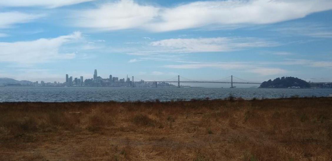
VIEWS OF THE BAY AND SAN FRANCISCO SKYLINE FROM ALAMEDA POINT
Source: East Bay Regional Park District
tidal marsh elements of the concept plan could support any flooding protection provided by the access road to the VA outpatient clinic and columbarium.
Partnership Opportunities
The Park District can increase its opportunities for funding the NW Territories concept plan by partnering with other public agencies and community organizations active on or near the site. These include the City of Alameda, the US Department of Defense, the Port of Oakland, and local non-profit organizations. City of Alameda
The City of Alameda and the Park District have already created a framework for partnership in the form of an MOU established in August 2020. The City departments most relevant to the NW Territories are the Base Reuse Department, Public Works Department and Recreation & Parks Department.
The City of Alameda will be an important partner in applying for grant funding for the NW Territories concept plan. The City applied for Measure AA grant funding for another site on Alameda Point, the proposed De-Pave Park. The City is also in the
early stages of a year-long effort to prepare to apply for federal predisaster mitigation grant programs, including the FEMA FMA and BRIC grant programs. The City’s intent is to package multiple sea level rise protection projects into one grant application. This package would include the NW Territories project and priority projects identified in the City of Alameda Climate Action and Resiliency Plan, the northern shoreline near the Webster and Posey Tubes, and the Veterans Court shoreline near the Bay Farm Bridge.
US Department of Defense
Two US Department of Defense agencies, the US Army Corps of Engineers (USACE) and the VA, are involved in redeveloping the site adjacent to the NW Territories site into the VA outpatient clinic and columbarium. USACE leads the project construction and the VA will be the end user of the site. The Park District has already started to engage with USACE and the VA on the design of the NW Territories and an on-site visitors center, which the VA may be in a position to fund. The Park District can demonstrate linkages between the VA’s goals for its site and the NW Territories concept plan’s contributions to VA visitors’ well-being and access to nature. By coordinating together, the Park District and USACE have an opportunity to achieve site designs that protect the VA site from sea level rise over time.
Port of Oakland Seaport
The NW Territories concept plan could reduce wave action at the mouth of the Oakland Estuary. This could provide benefits to the Port of Oakland Seaport, located on the other side of the channel. The Port may not yet have identified wave attenuation as a priority, but it could be interested in supporting future grant applications, such as the FEMA pre-disaster mitigation grants for which the City of Alameda is beginning to prepare.
Non-profit organizations
The NW Territories concept plan aligns with the goals of a range of non-profit organizations focused on veterans’ health and well-being, habitat restoration, and improved access to nature for low-income communities. These organizations present opportunities for supporting or partnering on future grant applications for the site.
Recommended Next Steps
The Park District can take the following actions to increase opportunities for funding the development of the NW Territories concept plan:
1. Continue to convene and coordinate with key partners, including the City of Alameda and Department of Defense agencies. 2. Consider including the Port of
Oakland Seaport in discussions of possible sea level rise and wave action protections offered by the NW Territories concept plan. 3. Coordinate with the City of
Alameda to support grant applications, including for
Measure AA and for FEMA predisaster risk mitigation grants. 4. Continue to coordinate with the VA on the possibility of its funding the construction of a nature center and seek to align its features with the services the VA aims to offer visitors to its outpatient clinic and columbarium.
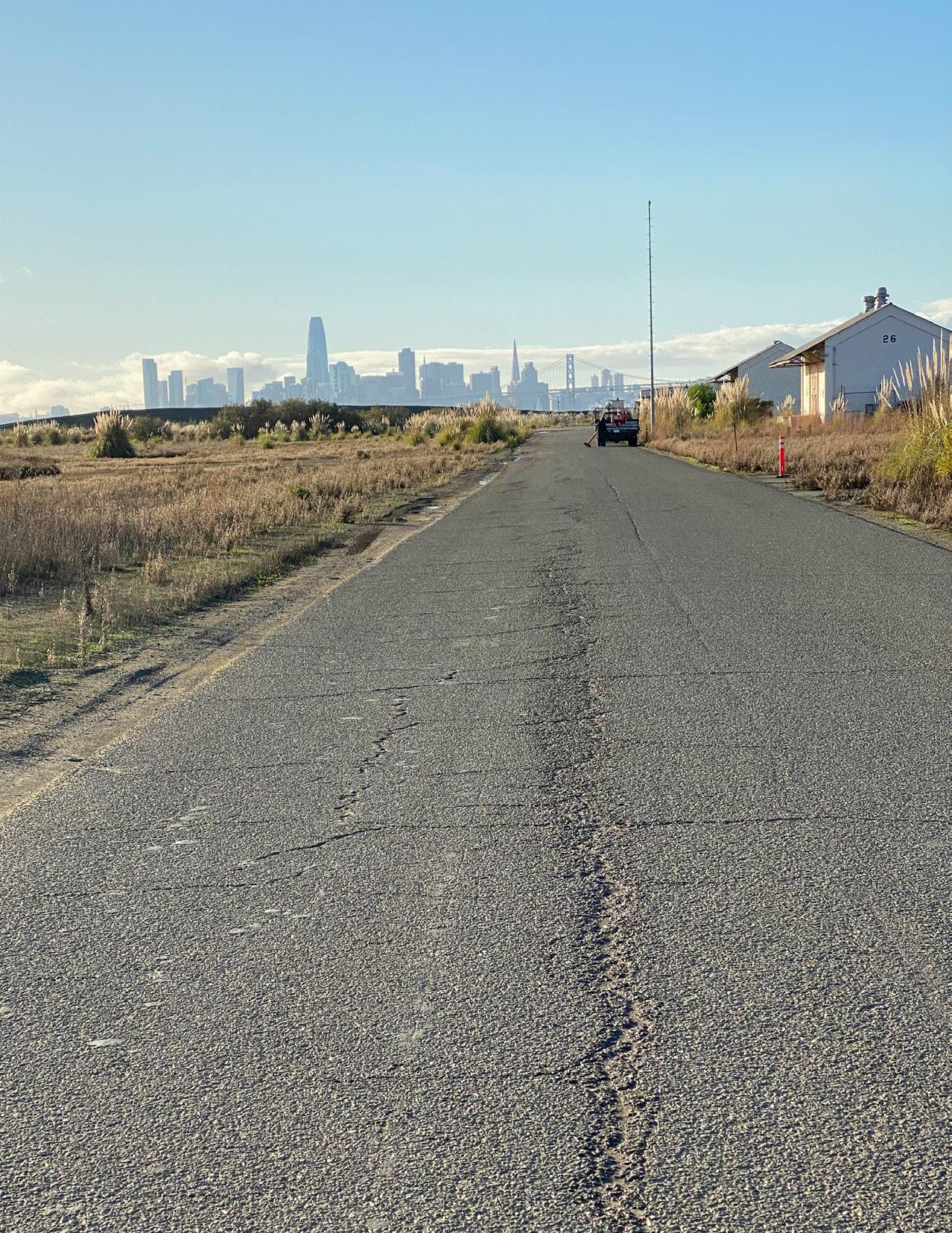
VIEWS OF ALAMEDA POINT
Source: WRT
McLAUGHLIN EASTSHORE STATE PARK
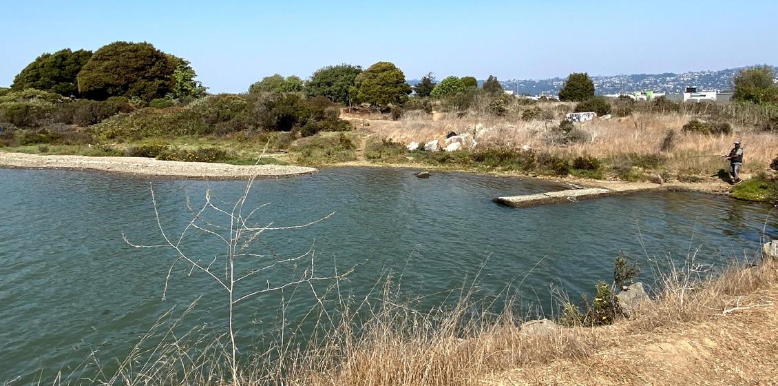
VIEW OF McLAUGHLIN EASTSHORE STATE PARK ALONG THE NORTH BASIN STRIP AND AT THE MOUTH OF SCHOOLHOUSE CREEK
Source: WRT
Planning Context and Key Stakeholders
The McLaughlin Eastshore State Park shoreline area is made up of a complex landscape of jurisdictional relationships. The state park is adjacent to city park areas, in addition to a critical transportation network that includes the Bay Trail, Interstate 80, and University Avenue access roads, making planning and coordination across multiple stakeholders critical. The design team and Park District organized a coordination meeting with the City of Berkeley, Caltrans, and Bay Trail representatives in order to discuss the ongoing planning efforts to address near-term and longterm challenges and opportunities at the site.
A clear area for collaboration in the future is centered on shoreline stabilization and access routes. Because of the property ownership limitations, the City of Berkeley is not able to explore nature-based shoreline adapation solutions independently without extensive encroachment on state park lands. By working together, the agencies could design resilient regional shoreline access that provides multiple benefits ecologically and to the local and regional community.
Nature-based adaptation solutions also benefit the region by diversifying the shoreline habitat types along the East Bay. Today, much of the shoreline is a combination of fill material and concrete revetment usually in the form of rip-rap. By working together across juridictions, the partners could reduce the pervasive extent of rip-rap along the
shoreline and provide a diversity of new habitat areas that also provide similar shoreline stabilization benefits.
Nature-based shoreline solutions also offer higher adaptive capacity when compared to shoreline hardening solutions. As sea levels rise throughout the coming century, shoreline areas with a wider range of elevations can support habitat migration across a transect of wetland to upland environments. This approach will be critical as sediment and resources become scarce across the Bay Area.
Another key area for collaboration at McLaughlin Eastshore State Park is at the connection of Schoolhouse Creek and the Bay. As identified in the General Plan in 2002, there are multiple benefits to daylighting Schoolhouse Creek within the park, including the creation of wetland habitat. As sea levels rise, the interaction between Bay and the creek will change, and the design of stormwater systems upland from the park will likely need modification. This offers the potential to coordinate with the City of Berkeley's green infrastructure initiatives to design opportunities for distributed stormwater retention and detention upstream.
Phased Approach to Adaptation
are elevated as part of an ecotone The following conceptual designs slope design along the perimeter of the Berkeley Meadow. propose a phased approach to In the end-of-century proposal, the adaptation in mid and end-of century access areas and ecotone slope conditions in McLaughlin Eastshore design are extended along all three State Park. In the mid-century sides of the Berkeley Meadow scheme, shoreline stabilization is to provide resilient public acess focused on a coarse beach approach while also making room for habitat along the Berkeley Meadow and migration. North Basin shorelines. The major access areas along Marina Drive and the future extension of the Bay Trail
FIGURE 4-16: McLAUGHLIN EASTSHORE STATE PARK: BERKELEY MEADOW AND NORTH BASIN DETAILED PLAN Source: Eastshore State Park General Plan, 2002
McLAUGHLIN EASTSHORE STATE PARK
Opportunities & Constraints
Based on existing elevations, the following maps show the extent of tidal and storm inundation across the site at mid-century and end-of century. The Bay Trail connections around the North Basin and Berkeley Meadow, are currently focused along the north edge of the meadow. The Bay Trail connections along University Avenue and Marina Boulevard are also important to include in future planning efforts. The connection to Schoolhouse Creek offers opportunities to provide tidal marsh wetland areas along the shoreline.
FIGURE 4-17: McLAUGHLIN EASTSHORE STATE PARK
Mid-Century - 3ft SLR


Key Considerations
• Nature-based shoreline stabilization opportunities along shoreline and trail and access road edges • Integration with Berkeley
Meadowrestoration • Opportunities for green infrastructure to alleviate future storm flooding in the City of
Berkeley • Key coordination to provide resilient access and habitat areas through end of century
FIGURE 4-18: McLAUGHLIN EASTSHORE STATE PARK
End-of-Century - 6ft SLR


McLAUGHLIN EASTSHORE STATE PARK
GROIN
COARSE BEACH
COARSE BEACH
ECOTONE LEVEE
WET MEADOW CREEK DAYLIGHTING
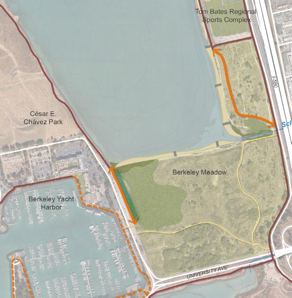
Mid-Century Concept Plan
The mid-century concept provides needed public access enhancements while implementing nature-based shoreline treatments that build longterm site resilience. A majority of the upland areas including the Berkeley Meadow and North Basin Strip remain intact through mid-century sea level projections (see figure 3-22). The exception is the western shoreline of the meadow, where the lowlying areas will become inundated. This concept embraces the natural processes set to occur and allows tidal marshes to begin to establish in the meadow. The daylighting of Schoolhouse Creek between the existing outfall and the frontage road offers opportunity to create freshwater wetlands and highlight the unique system of creeks along the East Bay shoreline. Existing public access in the North Basin Strip on gravel roads and trails is formalized to be clearly defined paths for bicyclists and pedestrians. Spur trails that degrade habitat areas are removed and the areas restored. The existing gravel road along the meadow shoreline is not improved due to near term inundation and longterm abandonment. Existing trails along the City’s Marina Boulevard are improved and incorporated into an ecotone slope extending into the Meadow.
FIGURE 4-19: McLAUGHLIN EASTSHORE STATE PARK CONCEPT PLAN
Mid-Century - 3ft SLR

McLAUGHLIN EASTSHORE STATE PARK
GROIN
COARSE BEACH
COARSE BEACH
ECOTONE LEVEE
WET MEADOW TRANSGRESSIONAL UPLAND HABITAT

CREEK DAYLIGHTING
End-of-Century Concept Plan
By end-of-century, significant inundation is projected to occur. This concept emphasizes a transgressional landscape where upland and seasonal freshwater habitats in the meadow shift to the North Basin Strip. The Meadow is envisioned to have two hydrologic connections to the bay. The first occurs where shown in the mid-century concept. The second is near the mouth of Schoolhouse Creek. Minor excavation would help create the convention and direct seasonal freshwater from the creek to the emerging wetlands. Shoreline treatments installed earlier as shown in the mid-century concept, are protecting the remaining upland areas and prevent waves from reaching the vulnerable tidal wetlands forming in the Meadow. These treatments also protect public access routes in the North Basin Strip. While portions of trails within Eastshore State Park are protected, major active transportation routes in the City of Berkeley along University Avenue and Marina Boulevard are subject to inundation by end-ofcentury. The concept plan proposes new pathways built above flood levels to connect to the Berkeley Marina along the north side of University Avenue. The frontage road which hosts the Bay Trail currently along the edge of the Meadow and North Basin Strip also requires elevating. Partnerships between landowners are required to ensure these adaptation strategies are achieved.
FIGURE 4-20: McLAUGHLIN EASTSHORE STATE PARK CONCEPT PLAN
End-of-Century - 6ft SLR

McLAUGHLIN EASTSHORE STATE PARK
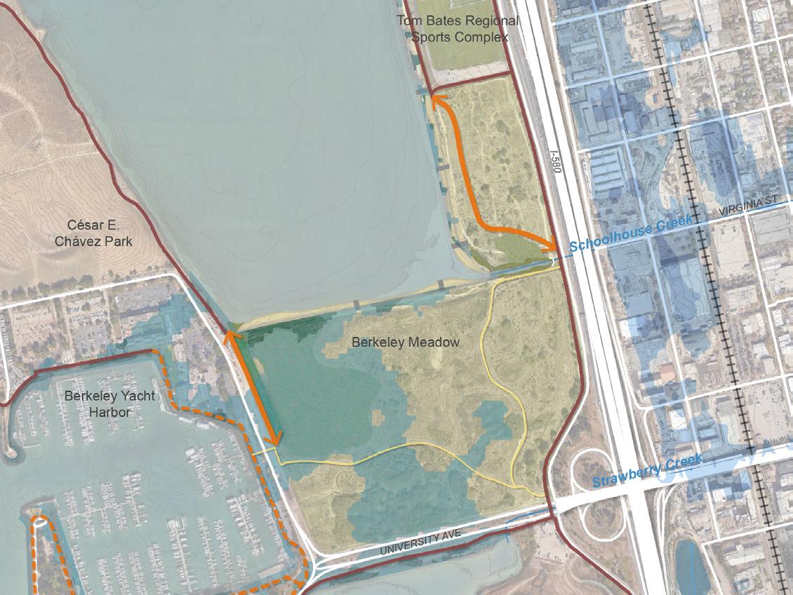
FIGURE 4-21: McLAUGHLIN EASTSHORE STATE PARK MID CENTURY CONCEPT PLAN WITH SLR INUNDATION
Mid-Century - 3ft SLR
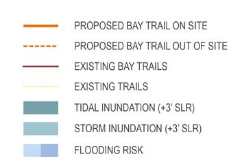
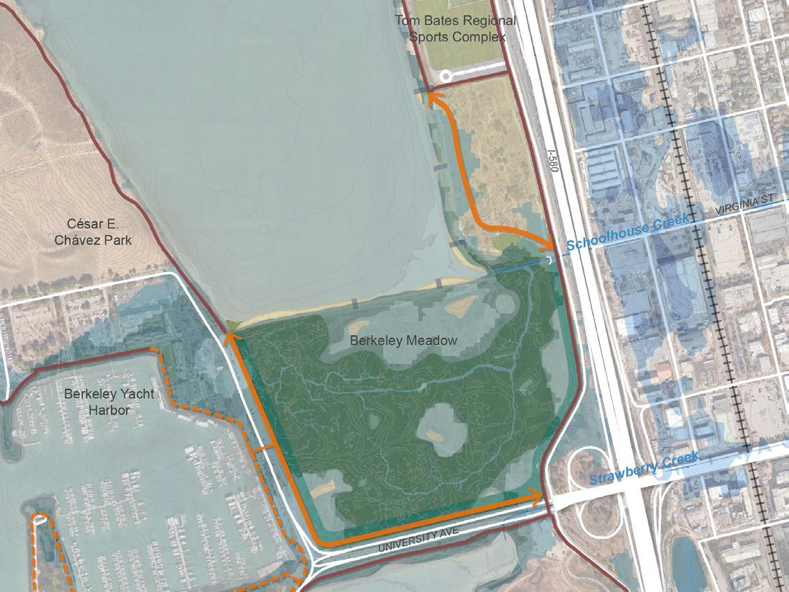
FIGURE 4-22: McLAUGHLIN EASTSHORE STATE PARK END OF CENTURY CONCEPT PLAN WITH SLR INUNDATION
End-of-Century - 6ft SLR

McLAUGHLIN EASTSHORE STATE PARK
COARSE BEACH UPLAND MEADOW
GROIN

FIGURE 4-23: McLAUGHLIN EASTSHORE STATE PARK MID CENTURY RENDERING

PROPOSED BAY TRAIL
EXISTING BAY TRAIL
CREEK DAYLIGHTING
McLAUGHLIN EASTSHORE STATE PARK
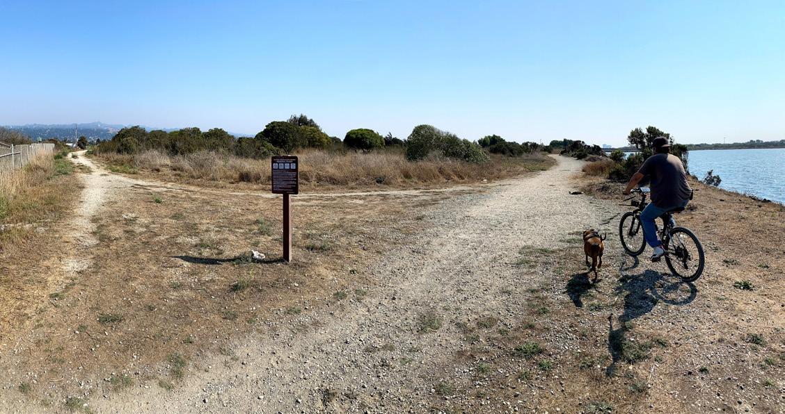
PEOPLE BIKING ALONG THE NORTH BASIN STRIP IN McLAUGHLIN EASTSHORE STATE PARK
Source: WRT
McLaughlin Eastshore State Park Funding and Partnership Strategy
This section provides an initial strategy for seeking funding for the McLaughlin Eastshore State Park prioritized concept plan. It identifies the elements of the concept plan that the Park District can highlight when seeking funding, the partners with whom the Park District can engage, and steps the Park District can take in the short term to position itself for future funding opportunities.
Site Features That Present Opportunities For Funding
The McLaughlin Eastshore State Park prioritized concept plan focuses on daylighting Schoolhouse Creek where it flows into the bay and restoring habitat to the north of the creek. The RAAPP concept plan for this site provides several benefits that could serve as the starting point for funding requests. These include access to nature and recreation opportunities, habitat restoration, non-motorized mobility, and protection against sea level rise.
Access to Nature and Recreation Opportunities
The concept plan proposes to daylight Schoolhouse Creek and create coarse beaches along the shoreline north of the creek. The daylighting of Schoolhouse Creek could provide new opportunities for youth environmental education, adding to programs currently
offered by the City of Berkeley Parks, Recreation & Waterfront Department and by the Park District. This could serve as the basis for seeking funding from foundations and grant programs aimed at increasing environmental education opportunities.
The concept plan also proposes water access through a coarse beach north of the creek. This access could position the Park District for grants such as Measure AA and others focused on shoreline access. While the site does not currently qualify for Disadvantaged Community status under the State’s mapping tool, a case can be made for the concept plan providing increase shoreline access to low-income populations living in Berkeley, Oakland and elsewhere in the East Bay. The development of additional pedestrian bridges over Interstate 80 further strengthens this case. Pedestrian bridge access to McLaughlin Eastshore State Park currently exists off of Addison Street, connecting south of Schoolhouse Creek. An additional pedestrian bridge is under development off Gilman Street, north of Schoolhouse Creek. Another pedestrian bridge is in the planning phase, which is expected to be at the Ashby Interchange and could increase access to McLaughlin Eastshore State Park for residents of Emeryville and potentially West Oakland. Habitat Restoration
The McLaughlin Eastshore State Park concept plan provides two alternative scenarios for the area north of Schoolhouse Creek: 1) the restoration of tidal marsh habitat and 2) the restoration of upland habitat. Either habitat restoration scenario could attract funding sources supporting habitat restoration and ecosystem health. If the restored habitat fosters the reintroduction of endangered species to the site, the project potentially could be used as a habitat mitigation bank, depending on the requirements of the agencies seeking the offsets.
Non-Motorized Mobility
The existing Bay Trail along McLaughlin Eastshore State Park serves as a bicycle commute route connecting jobs and housing along the East Bay. With the planned completion of the bicycle lane on the Bay Bridge span connecting Yerba Buena Island and the City of San Francisco, bicycle commuting on the McLaughlin Eastshore segment of the Bay Trail could increase. The McLaughlin Eastshore State Park concept plan proposes a way to reduce the impact of sea level rise on the existing Bay Trail and to divert some bicycle and pedestrian traffic closer to the shoreline. This could attract funding and support from organizations aiming to increase bicycle-based commuting and would align with existing climate action plans seeking to reduce transportation-based greenhouse gas emissions.
Protection Against Sea Level Rise
The proposed habitat restoration and daylighting of Schoolhouse Creek help lay the groundwork for future adaptations to sea level rise along the segments of the Bay Trail that parallel Caltrans roadways. The use of a nature-based near-term adaptation to sea level rise could provide the starting point for engaging with Caltrans on longer-term sea level rise protection needs. These efforts could attract planning grants and other funding opportunities to pilot approaches that could be applied throughout the Bay Area shoreline.
McLAUGHLIN EASTSHORE STATE PARK
Partnership Opportunities
The Park District will increase its opportunities for funding the McLaughlin Eastshore State Park Schoolhouse creek concept plan by partnering with other public agencies and community organizations active on or near the site. These include the City of Berkeley, Caltrans, and local non-profit organizations.
City of Berkeley
The Park District can benefit from coordinating with the City of Berkeley on McLaughlin Eastshore State Park adaptations to sea level rise, particularly in terms of gaining the City’s support or partnership on grant pursuits. In 2020 the City of Berkeley submitted a Measure AA grant application for habitat restoration and public access in the Berkeley Aquatic Park. The City could build on these efforts by supporting or jointly submitting a future Measure AA grant for the McLaughlin Eastshore State Park concept plan.
The Park District can also continue to coordinate with the City of Berkeley on environmental education opportunities offered through the City of Berkeley Parks, Recreation & Waterfront Department, as well as the City’s Marina Master Plan update. The Department of Public Works created in 2019 a Green Infrastructure Plan whose goals may align with the daylighting of Schoolhouse Creek. In any case, daylighting can serve as the start of a conversation on improving stormwater drainage from the neighborhoods east of Interstate 80 towards the Bay.
Caltrans
Caltrans owns and operates Interstate 80. The agency has not yet engaged with the Park District on opportunities to protect the interstate from sea level rise. The Caltrans State Bicycle and Pedestrian Plan, published in 2017, could serve as a starting point for communicating the value the Bay Trail brings to Caltrans bicycle and pedestrian goals. This could lay the groundwork for future conversations regarding sea level rise adaptation and how to protect Caltrans’ assets while also maintaining bicycle and pedestrian access.
Non-profit organizations
The McLaughlin Eastshore State Park concept plan aligns with the goals of a range of non-profit organizations focused on habitat restoration, creek daylighting, bicycle mobility, and environmental education. These organizations present opportunities for supporting or partnering on future grant applications for the site.
Recommended Next Steps
The Park District can take the following actions to increase opportunities for funding the development of the McLaughlin Eastshore State Park concept plan:
1. Take the lead on seeking funding sources, including Measure AA, and identify co-benefits that can attract joint applicants and supporters. 2. Continue to engage with
Caltrans to lay the groundwork for future coordination on protecting the Bay Trail and
Interstate 80 from sea level rise.
3. Continue to coordinate with the City of Berkeley to align the Schoolhouse Creek daylighting project with related City infrastructure initiatives, including the Green
Infrastructure Plan, the Marina
Master Plan Update, and projects funded by Measure M.
COARSE BEACH IN McLAUGHLIN EASTSHORE STATE PARK
Source: WRT

MARTIN LUTHER KING JR. REGIONAL SHORELINE

VIEW OF ARROWHEAD MARSH FROM THE MARTIN LUTHER KING JR. REGIONAL SHORELINE CENTER
Source: East Bay Regional Park District
Planning Context And Key Stakeholders
The Martin Luther King Jr. Regional Shoreline area is a complex tapestry of geography and ownership ringing San Leandro Bay. The impacts of sea level rise will adversely affect critical transportation networks, job centers, vulnerable communities, recreational assets, and highly productive estuary ecologies home to special status species. While solutions to any single challenge or location can be explored, all paths to adaptation lead to the need for a comprehensive approach. The Martin Luther King Jr. Regional Shoreline area can become a model for forging jurisdictional partnerships that achieve multiple benefits and deliver greater resilience.
The Physical Setting and Ownerships
San Leandro Bay is a tidal estuary along the eastern shoreline of San Francisco Bay. It terminates at the south end of the Oakland Estuary between the cities of Oakland and Alameda. To the east, the neighborhoods of East Oakland host vulnerable communities, industrial job centers, and major redevelopment sites like the Oakland Coliseum. The Park District’s Martin Luther King Jr. Regional Shoreline park provides important public shoreline access to adjacent communities. To the south and east, the Port of Oakland owns and operates the Oakland International Airport, and Caltrans owns and manages the shoreline road Doolittle Drive linking Hegenberger Road to Bay Farm Island and Alameda. The
Bay Trail rings the entire Bay with major trail segments in the Martin Luther King Jr. Regional Shoreline area and along Doolittle Drive. Planned bicycle connections extend inland from the Bay along San Leandro Creek.
The relatively calm waters are protected on the west from high energy bay waves by Alameda and Bay Farm Island, allowing a rich marine estuary to flourish. The ecological setting is anchored by Arrowhead Marsh, named for its distinctive shape as seen from above. Protected and federally-listed Ridgeway’s Rail and the Salt Marsh Harvest Mouse are notable species who call the marsh home. The Martin Luther King Jr. Regional Shoreline hosts a small tidal marsh at the mouth of Damon Slough. A majority of the other shoreline areas are covered in rock revetment, limiting its ecological value and thus making Arrowhead Marsh unique and an island habitat. Several freshwater creeks enter into the Bay from the east including San Leandro Creek, Lion Creek, and Elmhurst Creek. Recent research by SFEI highlights the regional habitat significance and suggests priority protection for the San Leandro Bay.
Key Issues
Arrowhead Marsh
Future sea level rise will destroy the marsh ecosystem by drowning the vegetation and causing the species who call it home to leave. There is limited upland areas adjacent to the marsh that can allow the gradual migration of habitat and species. Recent restoration efforts along the Airport Channel provide some benefit, but those areas too will become inundated by mid-century. Moving forward, the entire San Leandro Bay shoreline areas must be considered for future restoration and expansion of habitat beyond what exists today. This will require placement of beneficial fill into the bay to build up the land. Existing landward areas must be converted from parkland, roads, and even buildings to allow new marshlands to establish at higher elevations. While these actions are controversial, they must be considered as part of a comprehensive strategy to preserve the ecological value of San Leandro Bay and Arrowhead Marsh.
Doolittle Drive and Bay Trail
The CalTrans-owned Doolittle Drive and Park District-owned Martin Luther King Jr. Regional Shoreline with the Bay Trail are both subject to mid-century flooding that will cut off regional transportation routes. The shoreline area moving from inland to the bay is characterized by the airport and existing commercial land uses, the roadway, the Bay Trail, and shoreline park. The proximity of the road to the water in some areas makes elevating the Bay Trail impossible without either also elevating the road or placing the trail over the water. The complexity of permitting and potential environmental impacts make adaptation projects difficult if not impossible. In less constrained areas, there may be opportunities to solve for multiple benefits including protecting regional transportation assets and creating new shoreline habitat. Shoreline improvements may also double as protection against flooding for the airport. An example project could be elevating and relocating Doolittle Drive with the Bay Trail inland and adapting shoreline park areas for tidal marsh migration in a manner that also affords protection of the airport. While complex and expensive, a project supported by multiple jurisdictions will yield greater benefit and be better equipped to navigate permitting.
MARTIN LUTHER KING JR. REGIONAL SHORELINE
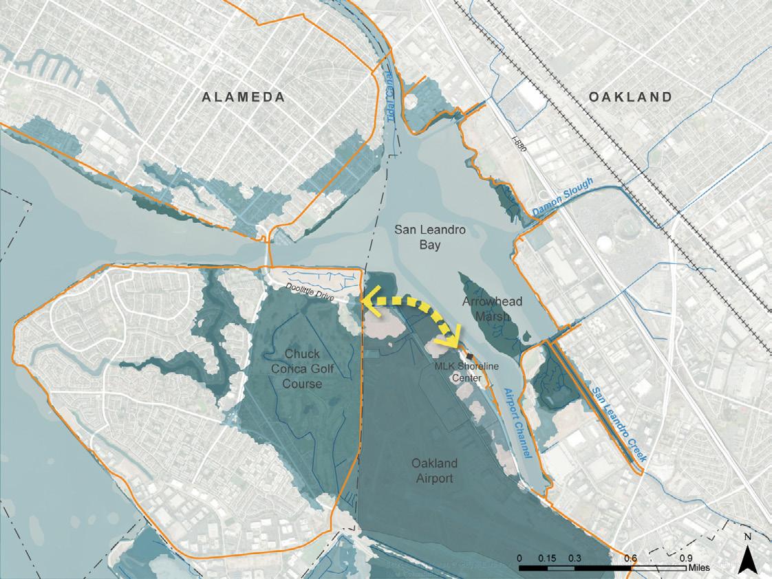
FIGURE 4-24: MARTIN LUTHER KING JR. REGIONAL SHORELINE
Mid-Century - 3ft SLR
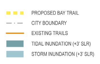
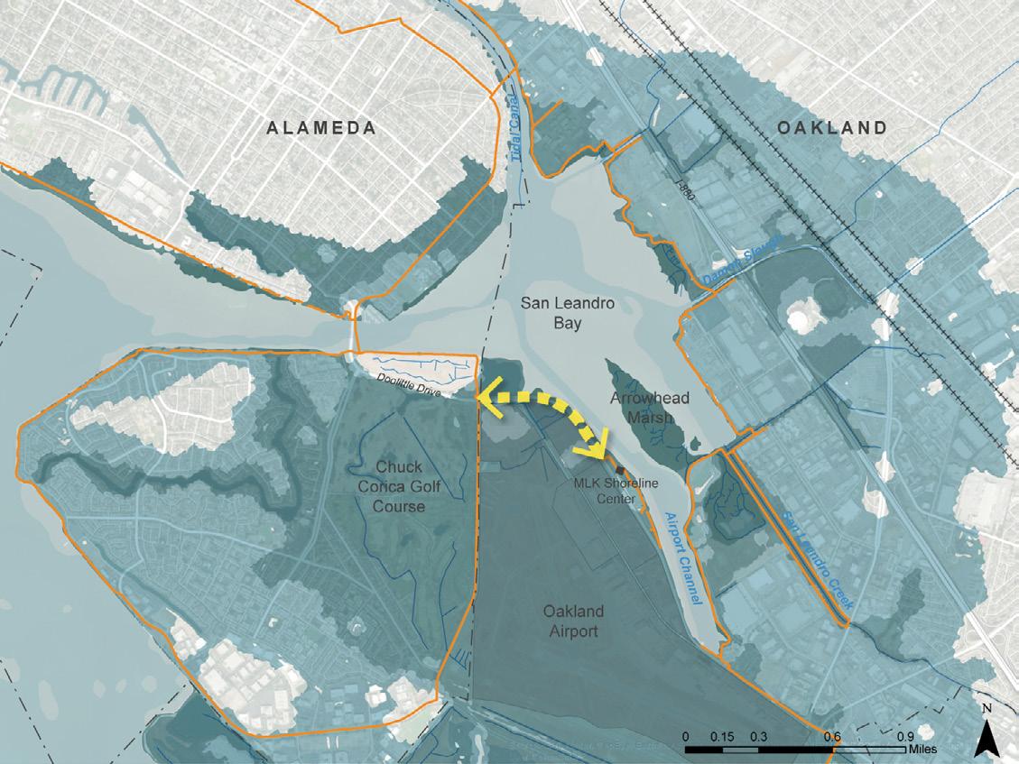
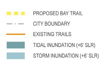
FIGURE 4-25: MARTIN LUTHER KING JR. REGIONAL SHORELINE
End-of-Century - 6ft SLR
MARTIN LUTHER KING JR. REGIONAL SHORELINE
This section provides an initial approach for engaging with partners along the Bay Trail segment that runs north along Doolittle Drive (State Route 61) from the MLK Jr Shoreline Center to the Bay Farm Island Bridge. As this concept plan depends on the actions of other partners, this strategy focuses on the partners with whom to engage.
Site Features that Present Opportunities for Funding
The northern Martin Luther King Jr. Regional Shoreline segment presents an opportunity to strengthen bicycle access along the Bay Trail between the City of Alameda (Bay Farm and Alameda Island) and the City of San Leandro. Given the risk of sea level rise along Doolittle Drive, this segment also presents the opportunity to contribute to the design of sea level rise adaptations to Caltrans assets in a way that preserves and enhances bicycle and pedestrian access.
Partnership Opportunities
The Park District's opportunities to increase bike access and adapt this portion of the Bay Trail to sea level rise will depend in large part on the other public agencies who own or are connected by this section of Doolittle Drive: Caltrans, City of Alameda, the City of Oakland, and the Port of Oakland.
Caltrans
Caltrans owns and operates State Route 61. The agency has begun to engage with the Park District and other stakeholders on the need to protect the Doolittle Drive section of State Route 61 in the near term from high tides and rising sea levels. The Park District can continue to engage with Caltrans and other interested stakeholders on the design of a raised or otherwise modified road and to communicate the need for the design to include bicycle access. The Caltrans State Bicycle and Pedestrian Plan, published in 2017 could serve as a starting point for communicating the value the Bay Trail brings to Caltrans' bicycle and pedestrian goals. City of Alameda
As mentioned in the Alameda Point section, the City of Alameda is in the early stages of a year-long effort to prepare to apply for federal predisaster mitigation grant programs, including the FEMA, FMA, and BRIC grant programs. The City’s intent is to package multiple sea level rise protection projects into one grant application, including the Veterans Court shoreline near the Bay Farm Bridge. As this area is just along the northern end of Doolittle Drive, the federal grant application could provide an opportunity for both the Park District and Caltrans to partner with the City of Alameda in seeking funding to protect the areas near Bay Farm Bridge from sea level rise while also providing Bay Trail bicycle access. Increasing bicycle access along this section could align with the Alameda Active Transportation Plan, currently under development.
Port of Oakland Airport
Any efforts to raise or otherwise modify Doolittle Drive to protect it from sea level rise will affect – and potentially benefit – the Port of Oakland Airport’s plans to adapt its runways and facilities to sea level rise. While bicycle access is likely not a priority co-benefit in these plans, it will be useful to continue
to communicate the Park District's priorities in conversations with the Port and other stakeholders about changes to Doolittle Drive.
City of Oakland
This section of Doolittle is mostly within the City of Oakland. The Park District can continue to engage as needed with the City of Oakland on ways to increase Bay Trail access along the Martin Luther King Jr. Regional Shoreline.
Recommended Next Steps
The Park District can take the following actions to increase opportunities for funding the development of the Bay Trail along the northern segment of Doolittle Drive:
1. Continue to coordinate with key partners to raise awareness for the need for a bike lane in any future changes to Doolittle
Drive to adapt to sea level rise.
The Park District may have the opportunity to play a convening role to keep highlighting the multiple co-benefits associated with protecting Doolittle Drive from sea level rise in a way that provides Bay Trail bicycle access. 2. Coordinate with the City of
Alameda to support grant applications for FEMA predisaster risk mitigation that involve the Veterans Court / Bay
Farm Island Bridge area.
