Bachelor of Landscape Gardenning
Email: xuansan011230@163.com
Phone:+86 15383998032
Education:
Nanjing Forestry University Sept2019--July2023

Bachelor of Landscape Gardenning
Email: xuansan011230@163.com
Phone:+86 15383998032
Education:
Nanjing Forestry University Sept2019--July2023
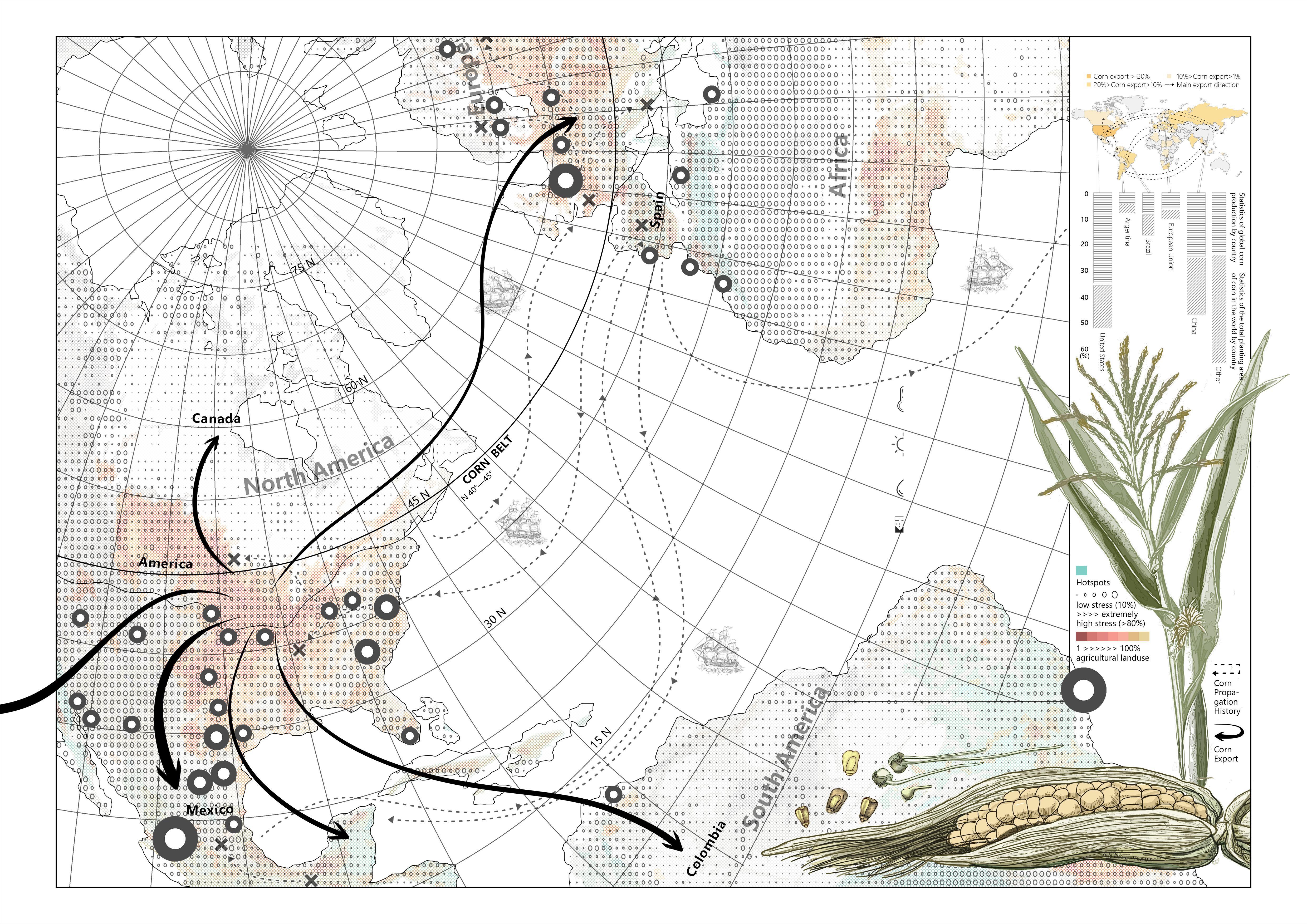
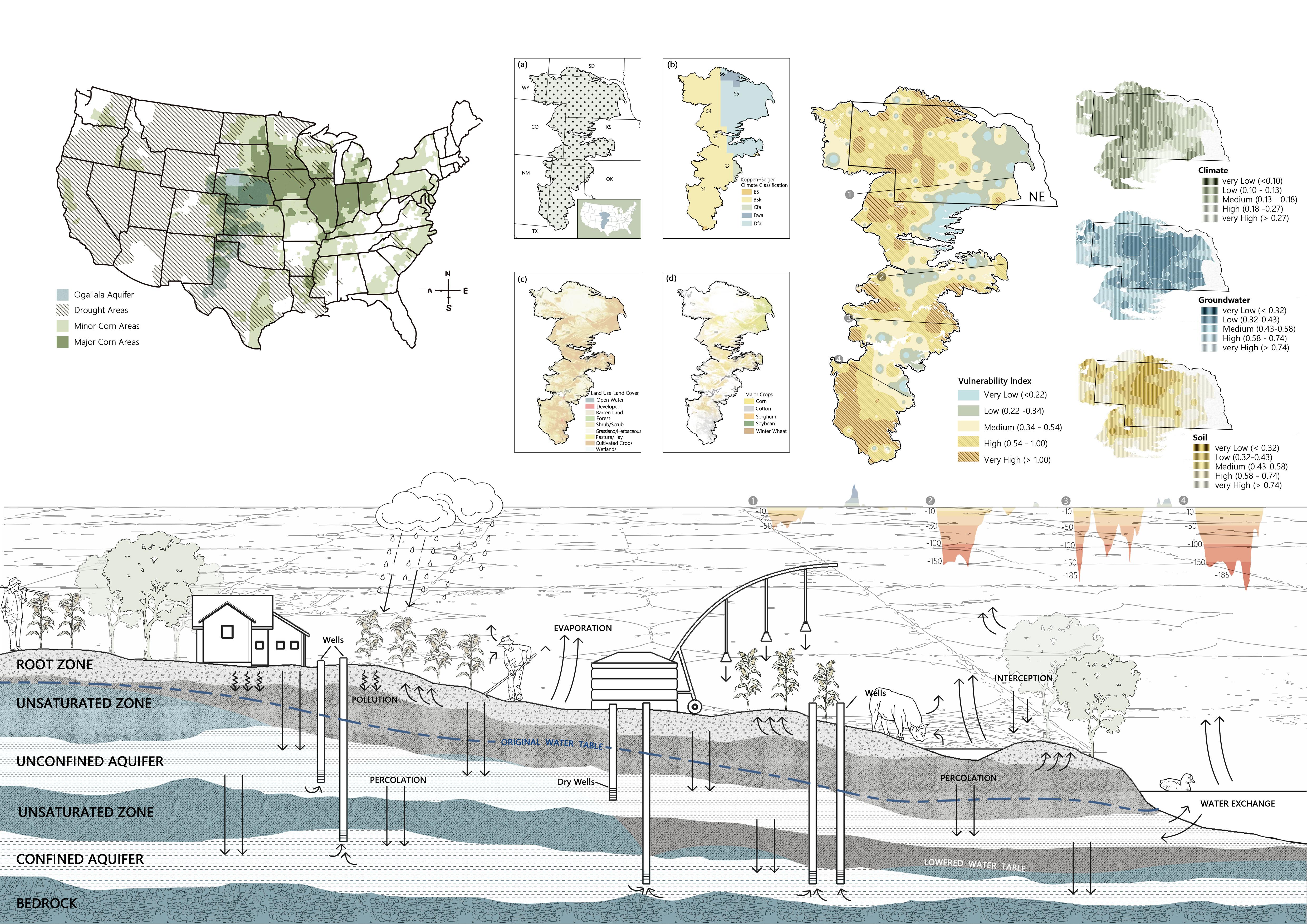
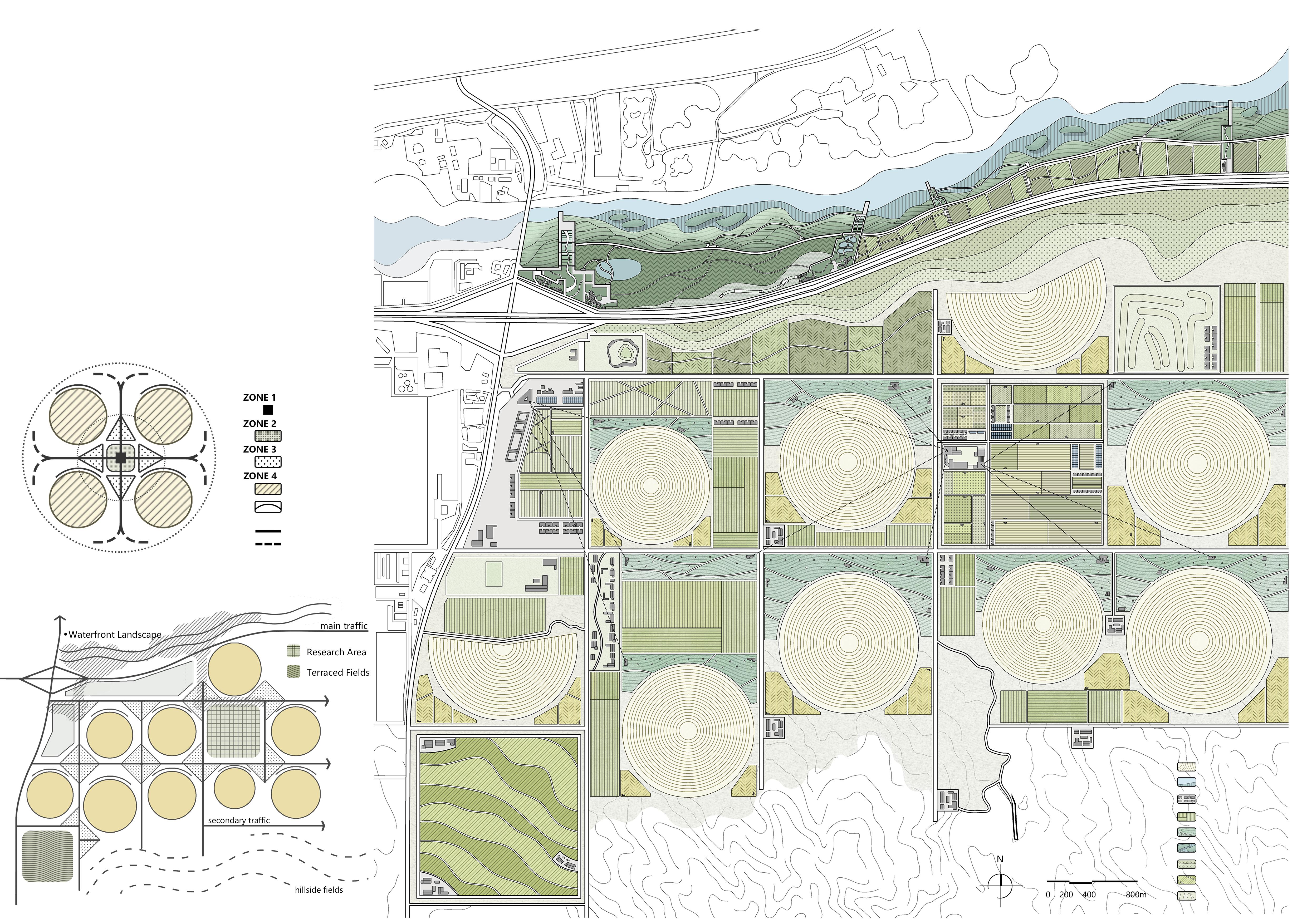
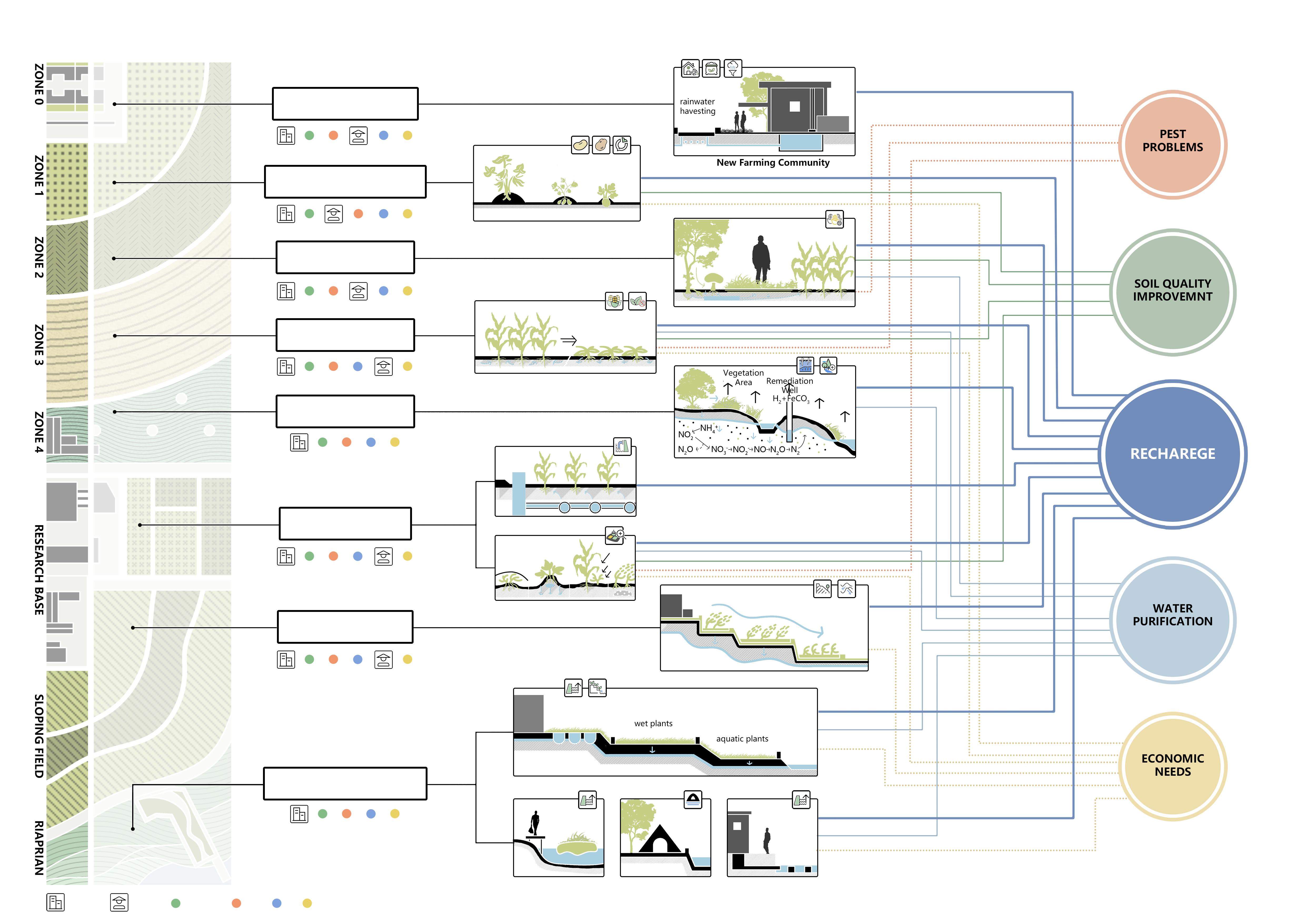
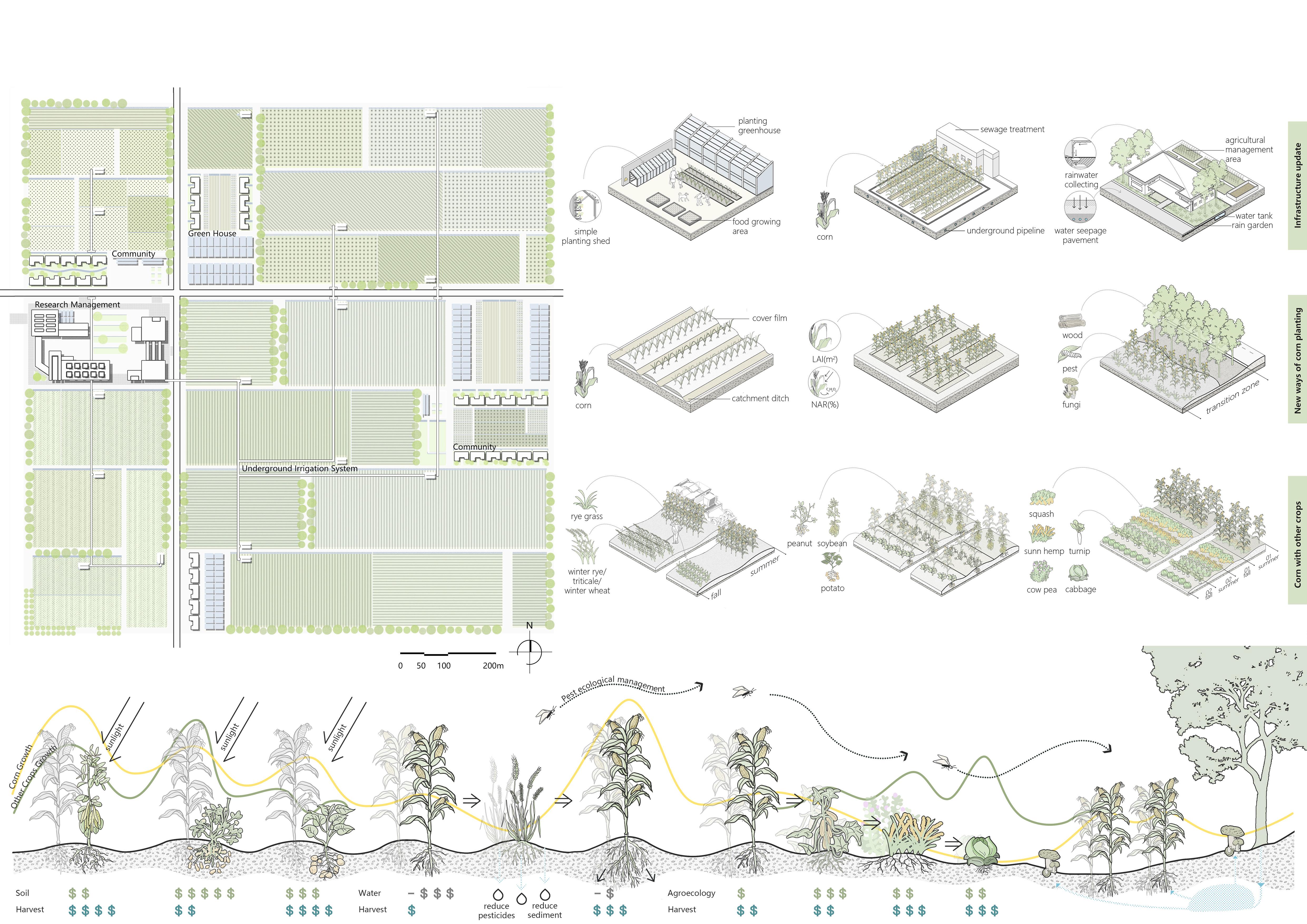
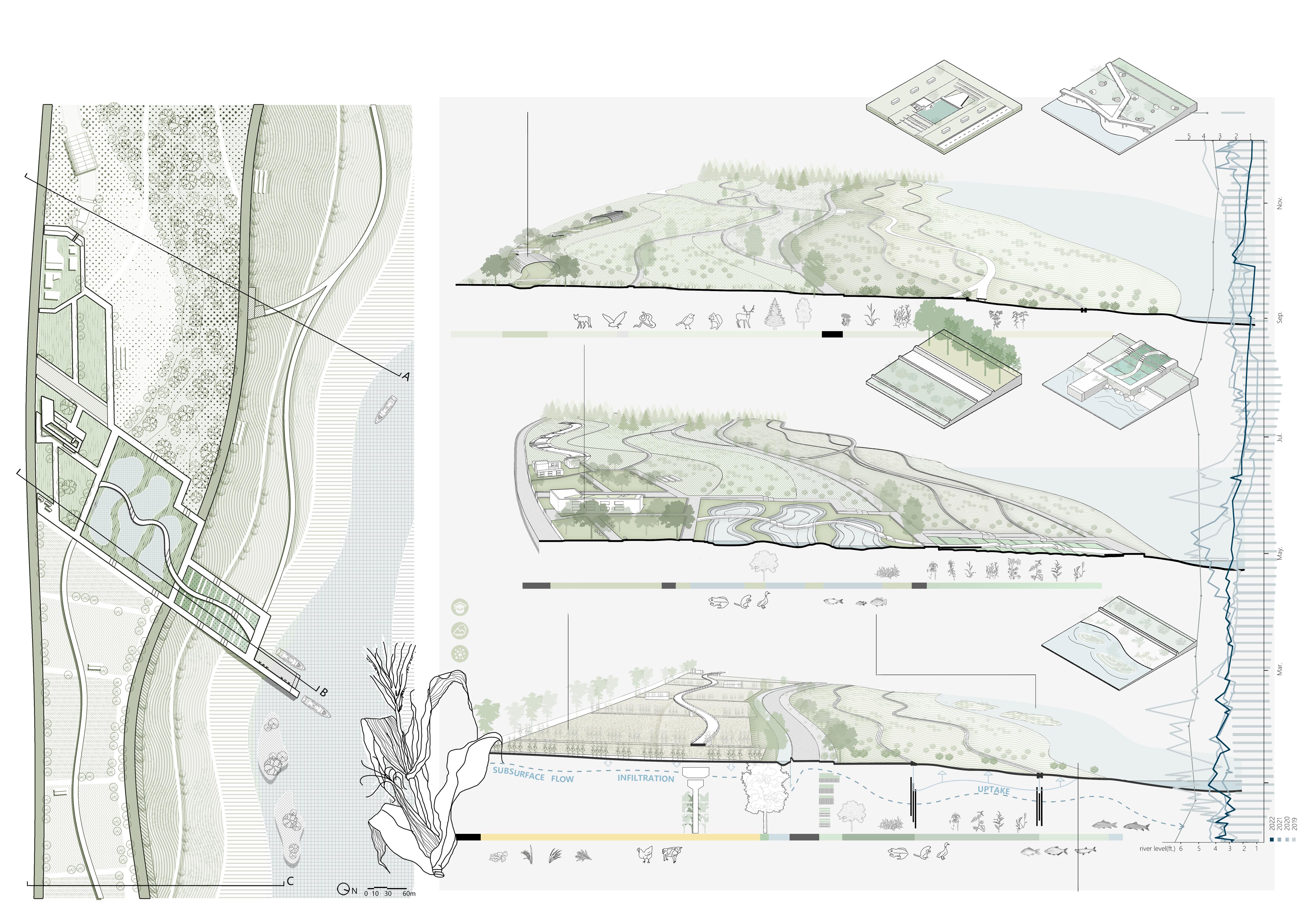
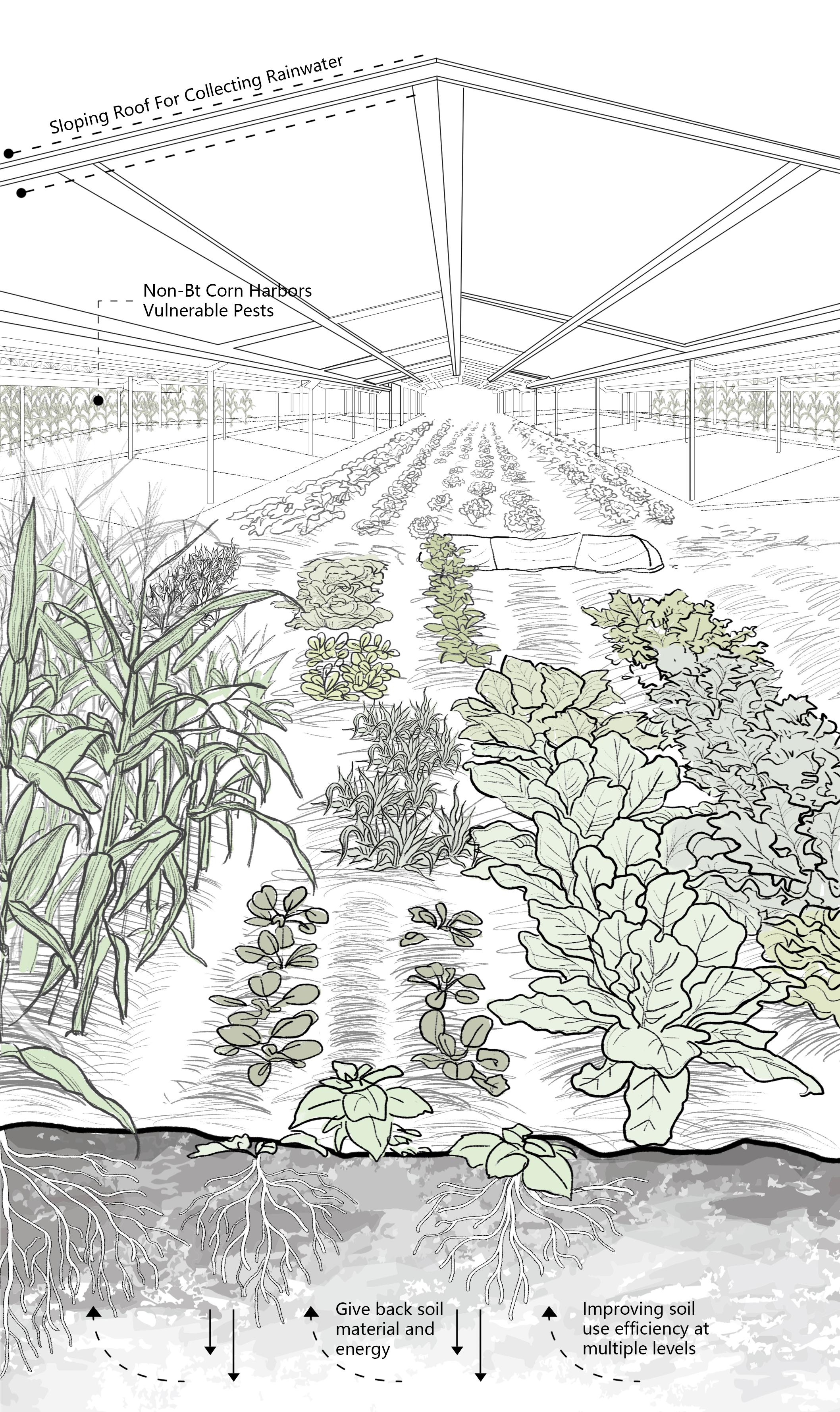
The site is in the city of Ogallala, which is in the southwestern part of Nebraska, near the South Platte River. Corn fields spread along the gentle slope in the southeast of the city. they are gradually eroding the native planting communities and threaten water resources with pollution.
Aiming at this problem, we proposed some test plot to explore a sustainable way of farming to increase water recharge, water purification. In terms of agriculture, the concept of permaculture is introduced, and the existing corn fields and residential areas are managed as a whole, and the renovation and agricultural planning are carried out in layers. And set up a centralized research area on the site to explore the benefits of new planting models and planting techniques.
The reconstruction of the riverbank is to set up different forms of water purification areas in combination with the slope, and plant corresponding water purification plants to reduce the remaining pollution from uphill planting. At the same time, combined with the existing condition and local community, a scenic area and waterfront trail are set up to bring new education programs and recreation program.
-16th century
Corn grown in the colder regions of North America, such as the northern United States and the southwestern part of Canada, was introduced to regions from central to northern Europe such as the United Kingdom, France, and Germany.
recycling of marine waste but also to revitalize the overall landscape.
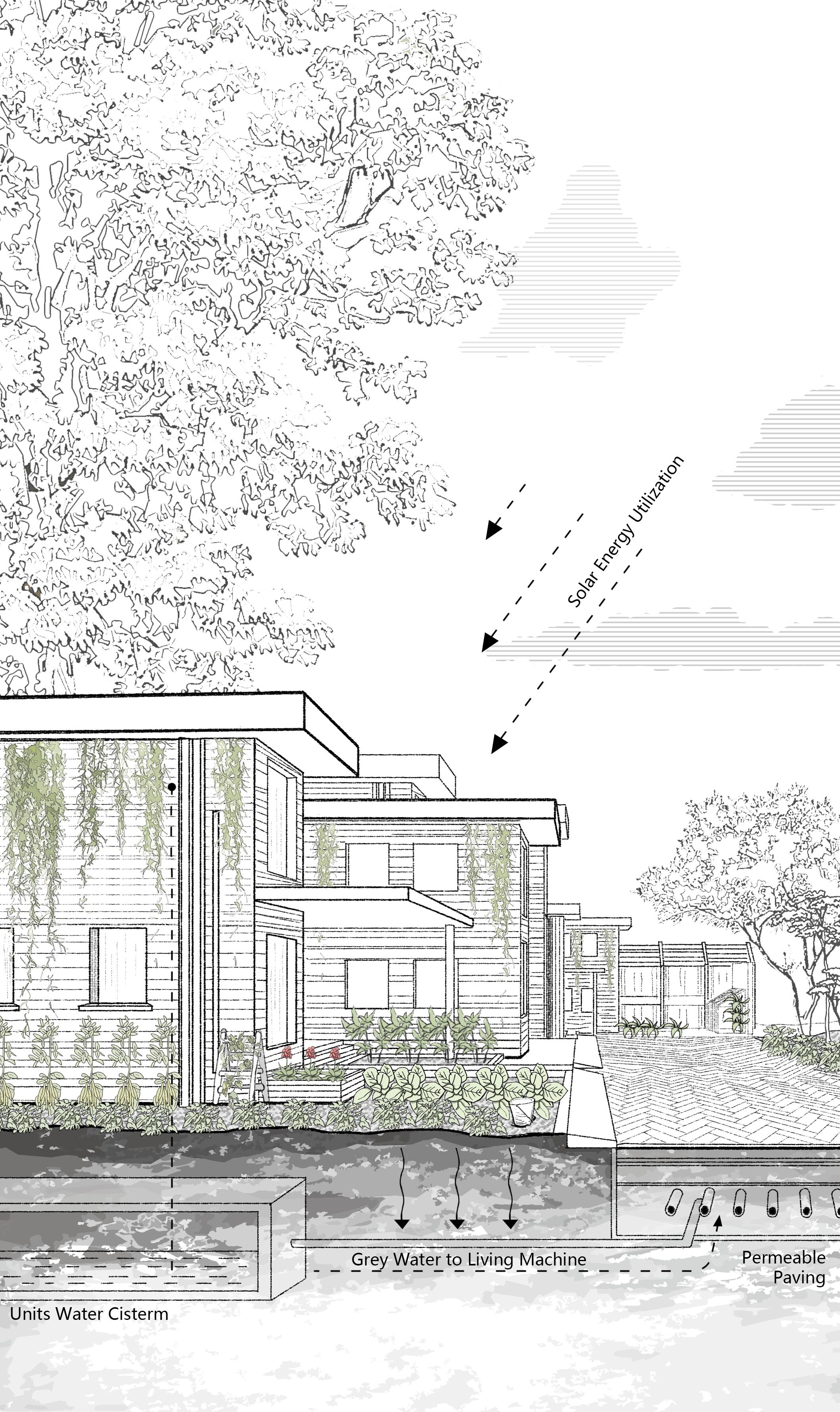
With a people-centric approach, my designs emphasize community co-creation, participatory design, and sustainable urban spaces. Beyond visual aesthetics, focus on comprehensive aspects like economics, governance, education, and cultural heritage, aiming to contribute to more meaningful and sustainable city landscapes.
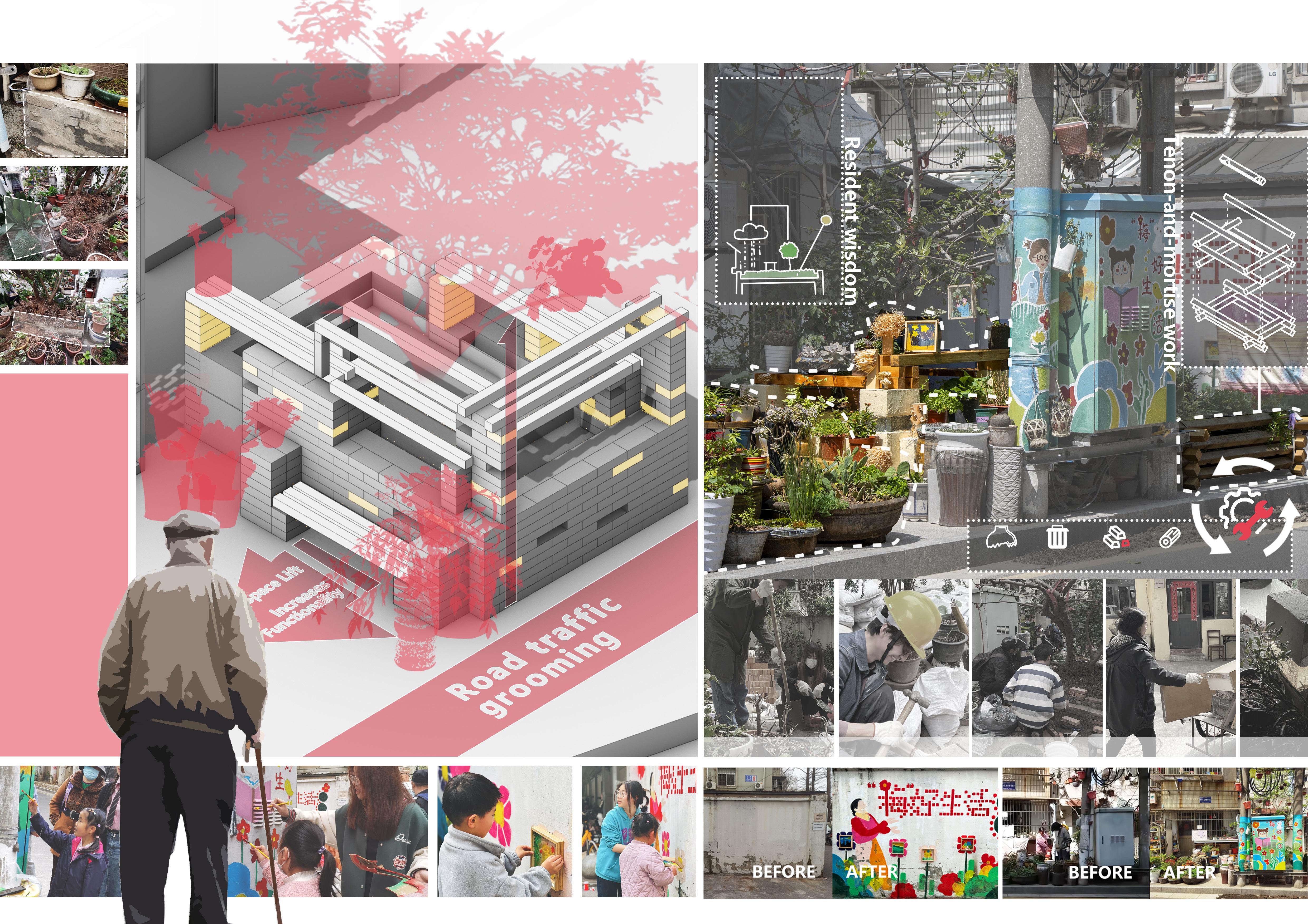
The Red Flag New Village community in Nanjing's Xuanwu District faces challenges due to aging infrastructure and insufficient landscape design, resulting in a subpar living experience for residents. Our approach involves introducing multi-solution planning and organizing diverse public activities to enhance community life. Through low-cost creative landscapes and product designs, we aim to uncover the unique aesthetic value of historical elements, fostering a new cultural atmosphere. The project is designed to improve residents' satisfaction and revitalize community culture.
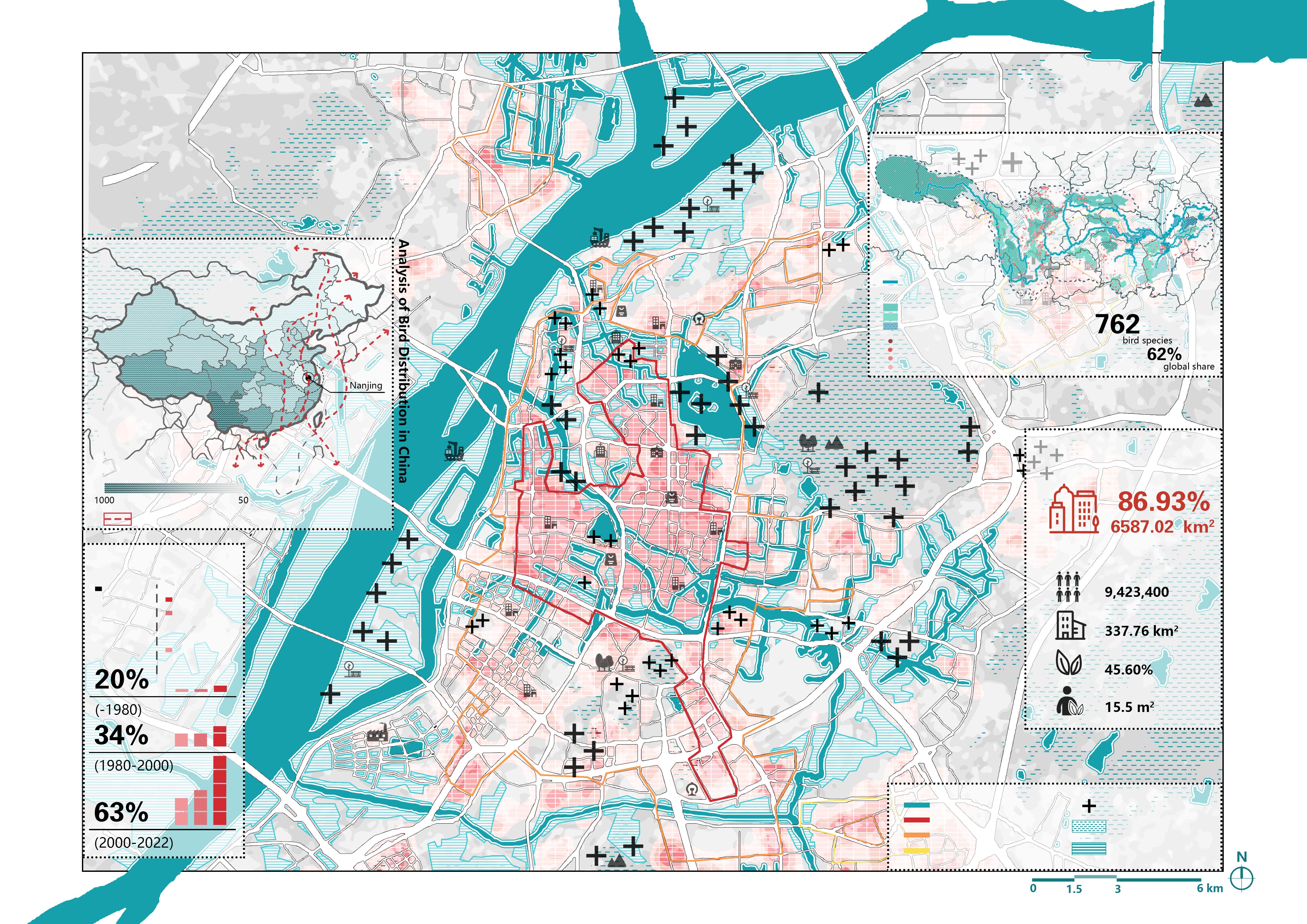
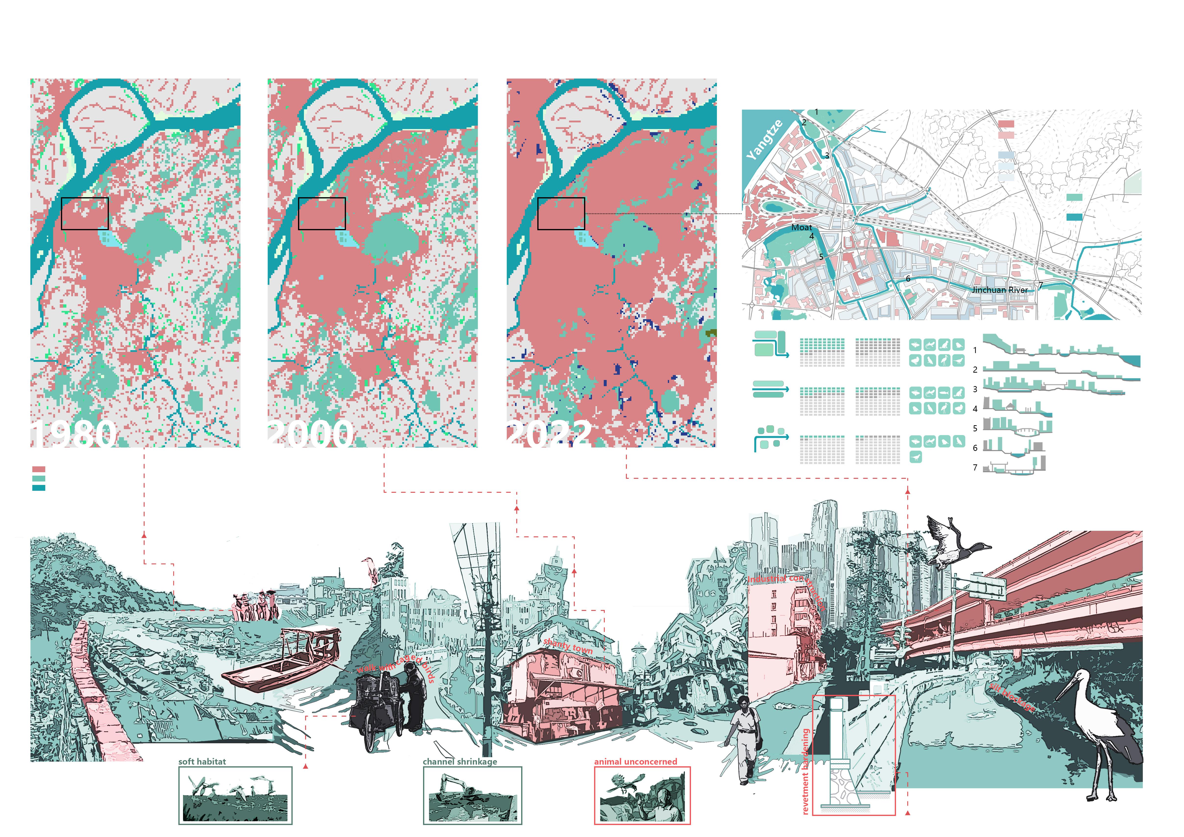
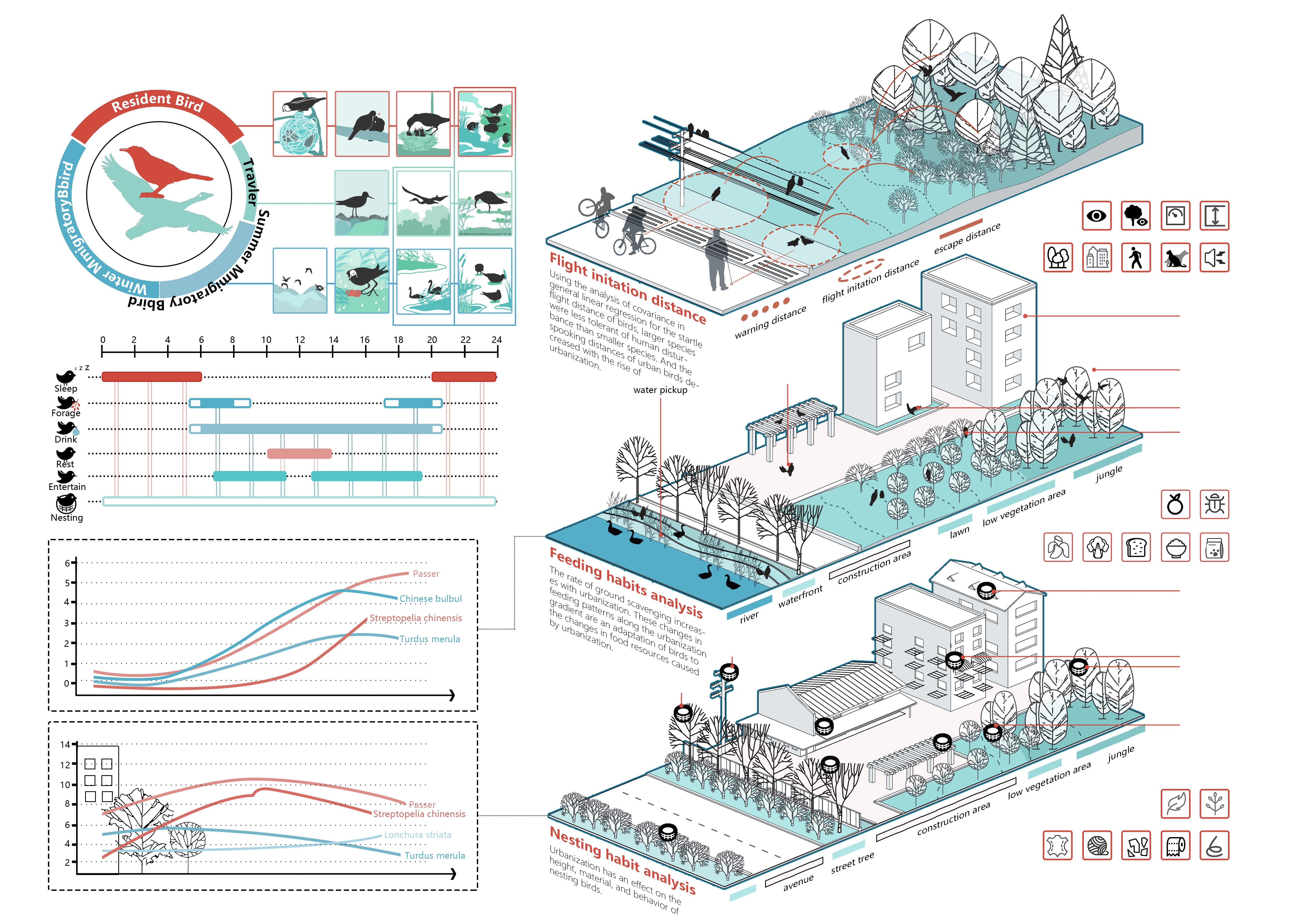
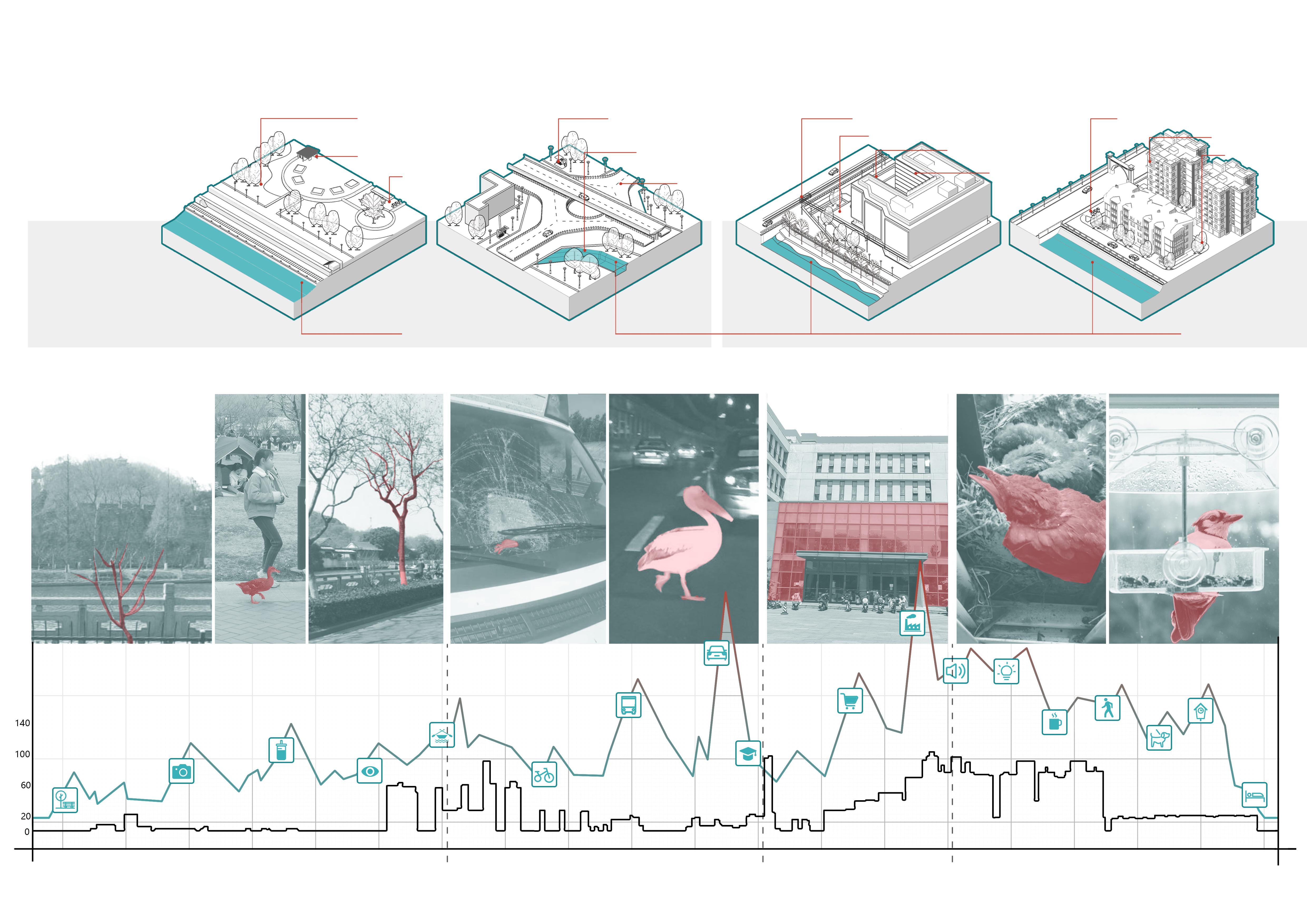
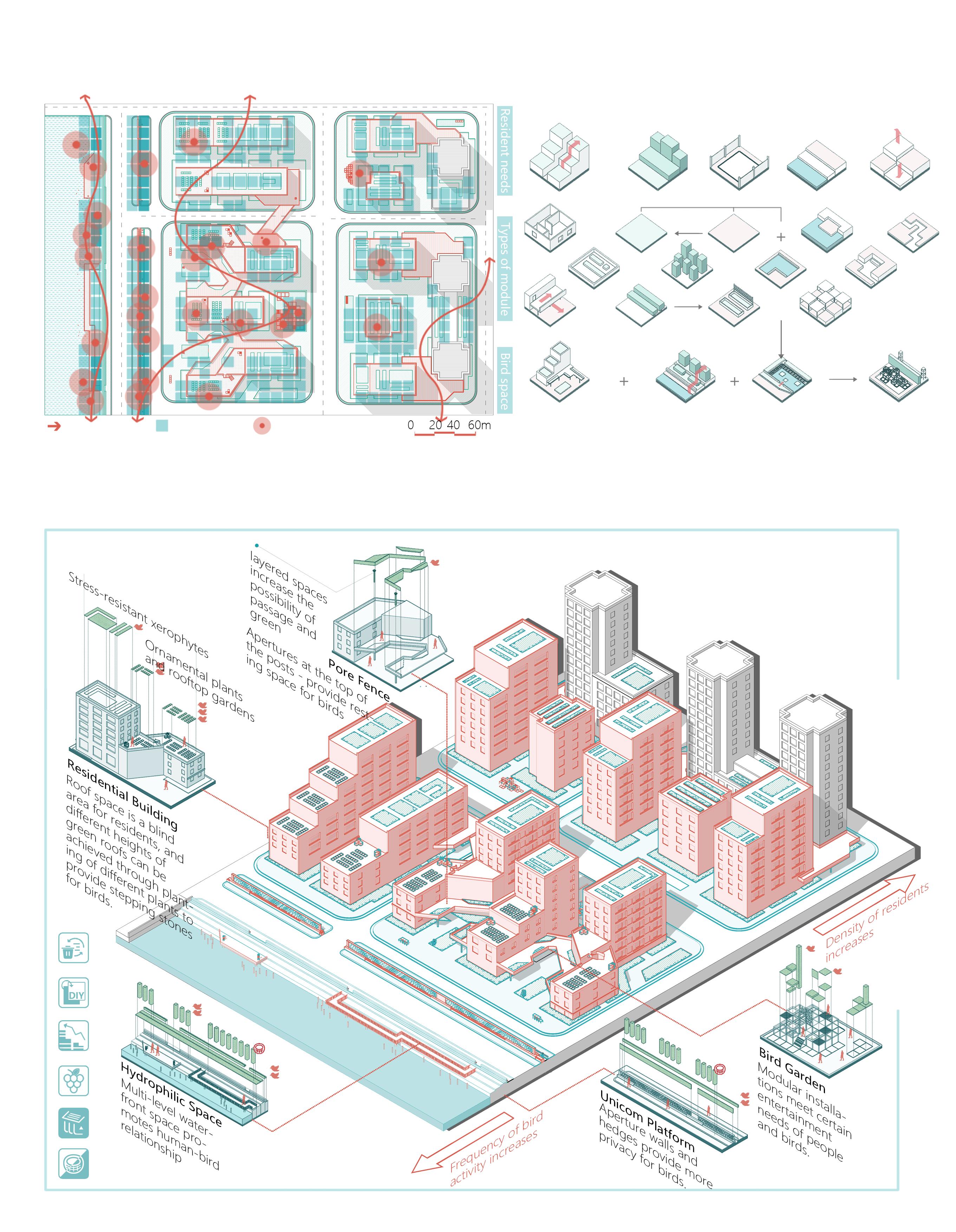
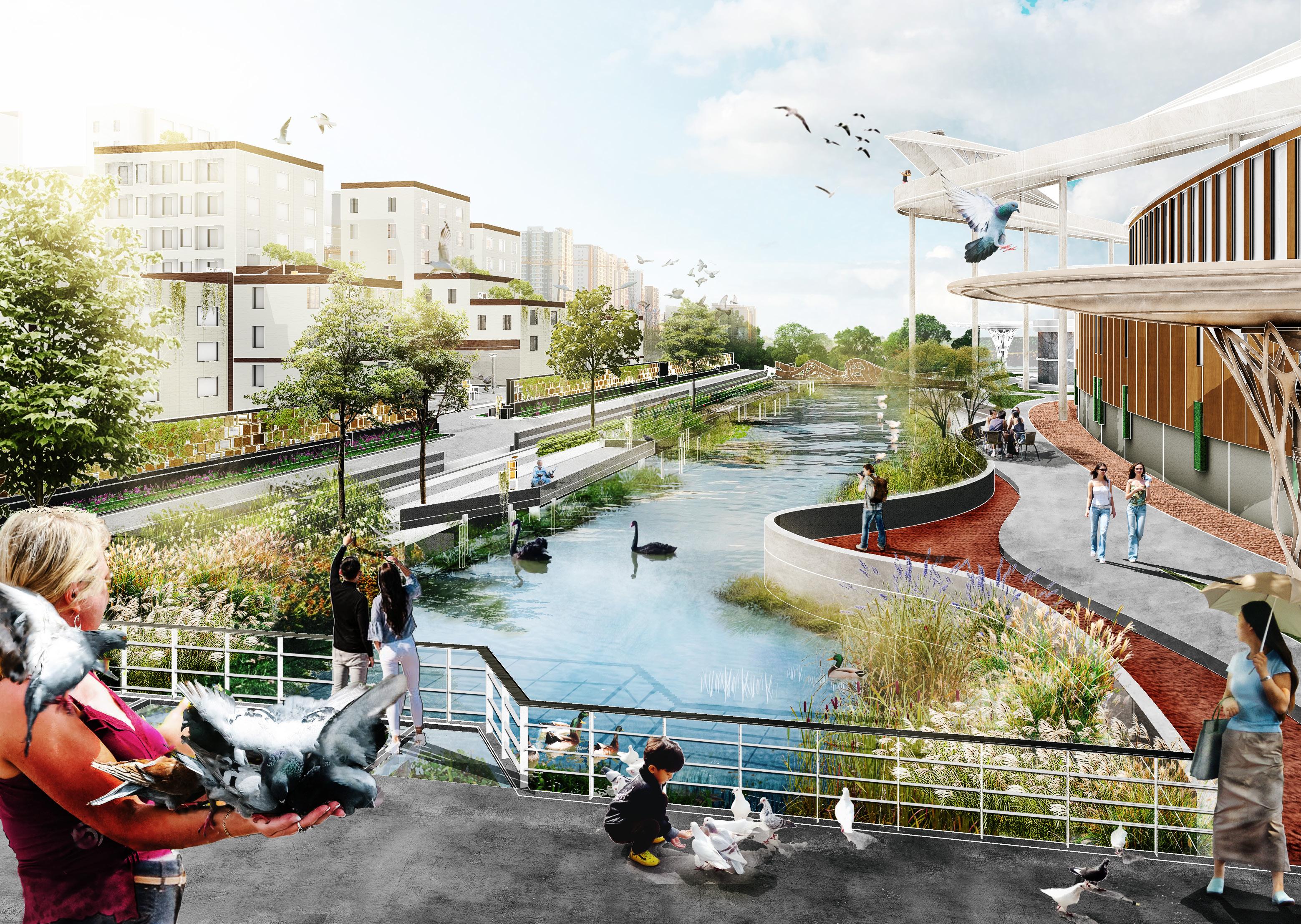
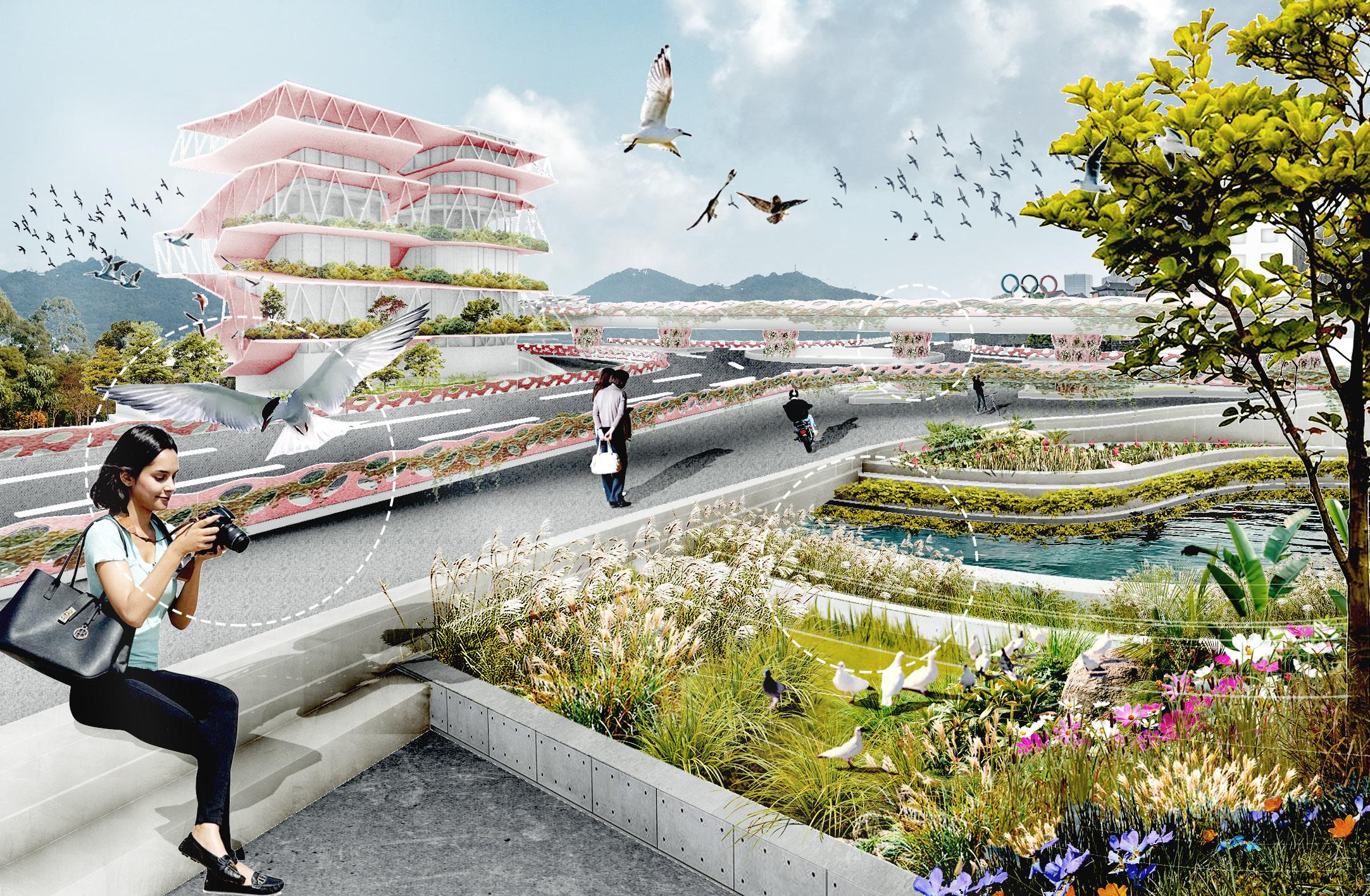
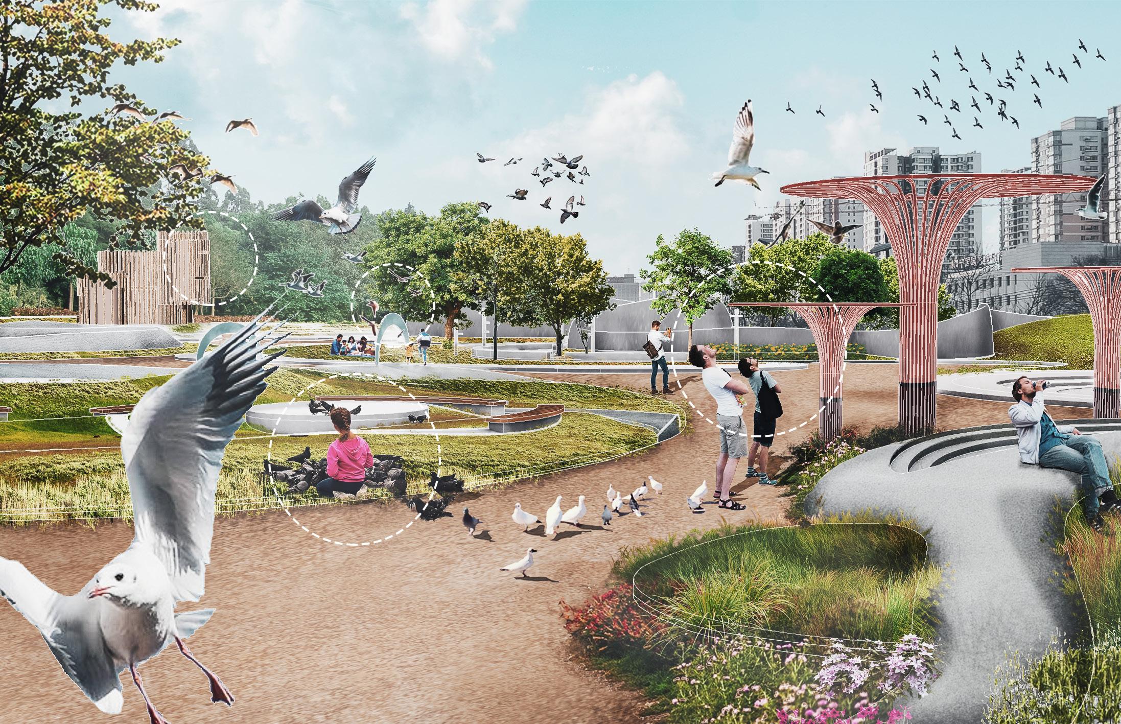
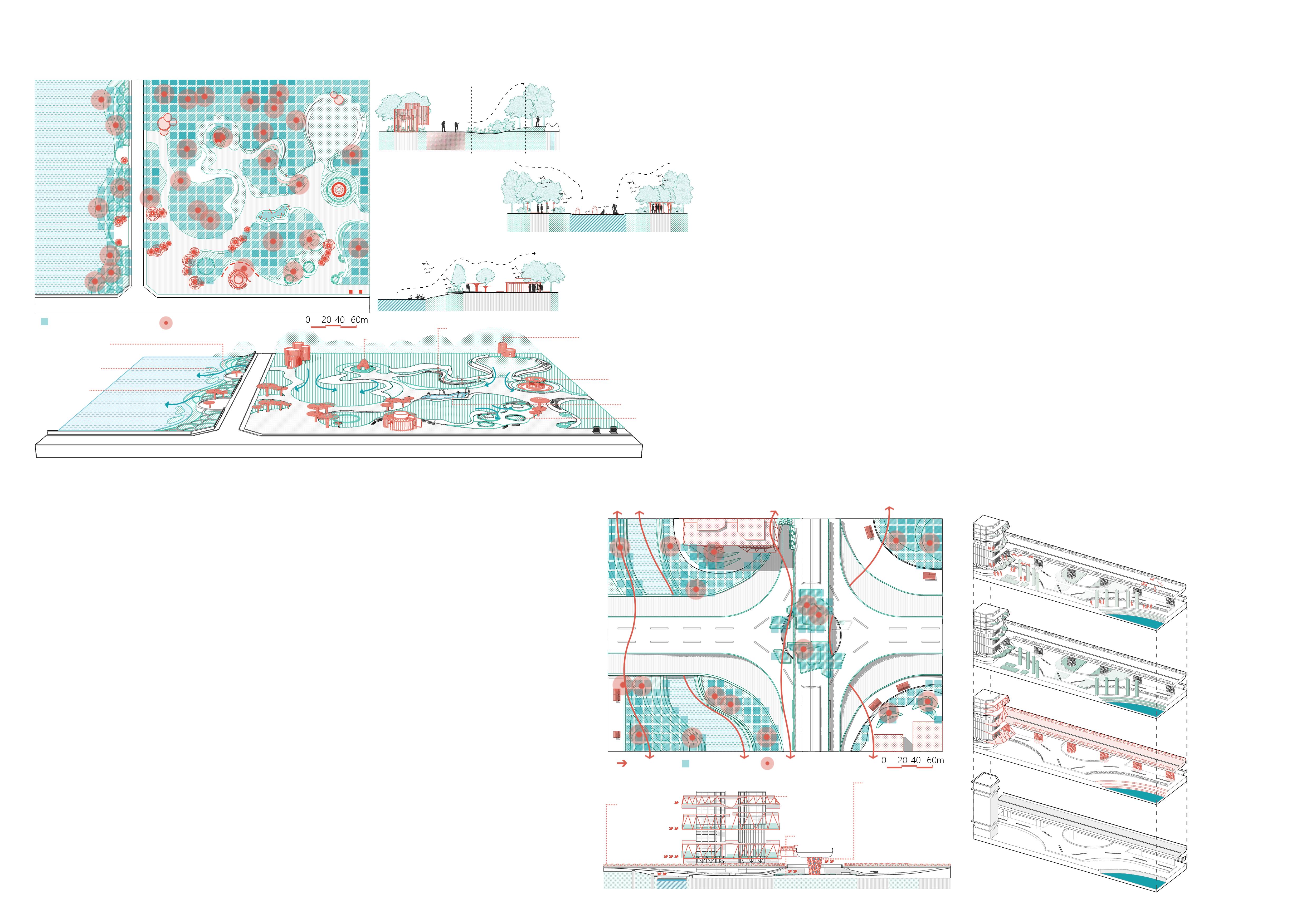
This project focuses on improving the urban living environment by incorporating bird-friendly design, promoting ecological habitats for birds, and creating a harmonious balance between urban development and natural ecology. Through thoughtful landscaping, we aim to enhance the overall quality of the city while providing safe and suitable habitat for birds, contributing to biodiversity and offering residents a richer natural experience.
As urbanization advances rapidly, many cities encounter a range of challenges in their development, including floods, ecological degradation, a lack of diverse blue-green infrastructure, and the absence of traditional historical and cultural elements in their sites. Urban residents express a desire to connect with urban culture and natural landscapes, yet suitable spaces for such experiences are often lacking.
-1493
Corn was inadvertently brought back to Europe by Columbus on his first voyage back to Spain. However, due to the cold climate in Europe, corn cultivation has not yet been fully popularized.
-After the 16th century
After someone brought maize from the central plateau of Mexico back to cultivation, maize began to be widely planted in the warmer European regions of Spain and the Mediterranean coast of Italy.
-1502 or so
Maize planting has also started in northern Spain.
Most of the world's corn producing areas are concentrated in July with an isotherm of 21-27°C.
Corn is a short-day plant, which can flower and set fruit under short-day (8-10 hours) conditions.
Maize plants are tall and have large leaf area, so they need more water.
The soil is loose, deep, organic matter-rich chernozem, chestnut soil and sandy loam, and corn can be grown in the pH range of 6-8.
-1620 or so
A group of 102 Pilgrims immigrated to Plymouth (Massachusetts) on the Mayflower, and the remaining corn helped them survive the harsh winter.
In the Spring Festival, an aborigine taught the immigrants to plant corn and other agricultural skills, and the first Thanksgiving in the United States was born.
Due to the special organs of corn, it is difficult to rely on animals for its reproduction and sowing, and the growth and evolution process is basically through artificial breeding.
-Around 1000 BC
With corn as the mainstay, lentils, pumpkins, and three crops are mixed at the same time, and a unique corn planting method has been developed.
-5000 BC
The aborigines of the New World dominated by the Mayan civilization and the Aztec Empire began to grow corn.
-1500 BC
Corn appeared with cobs similar to today's.
268,504,000 people live in the largest 20 cities affected by water shortages due to geographical or financial limitations.
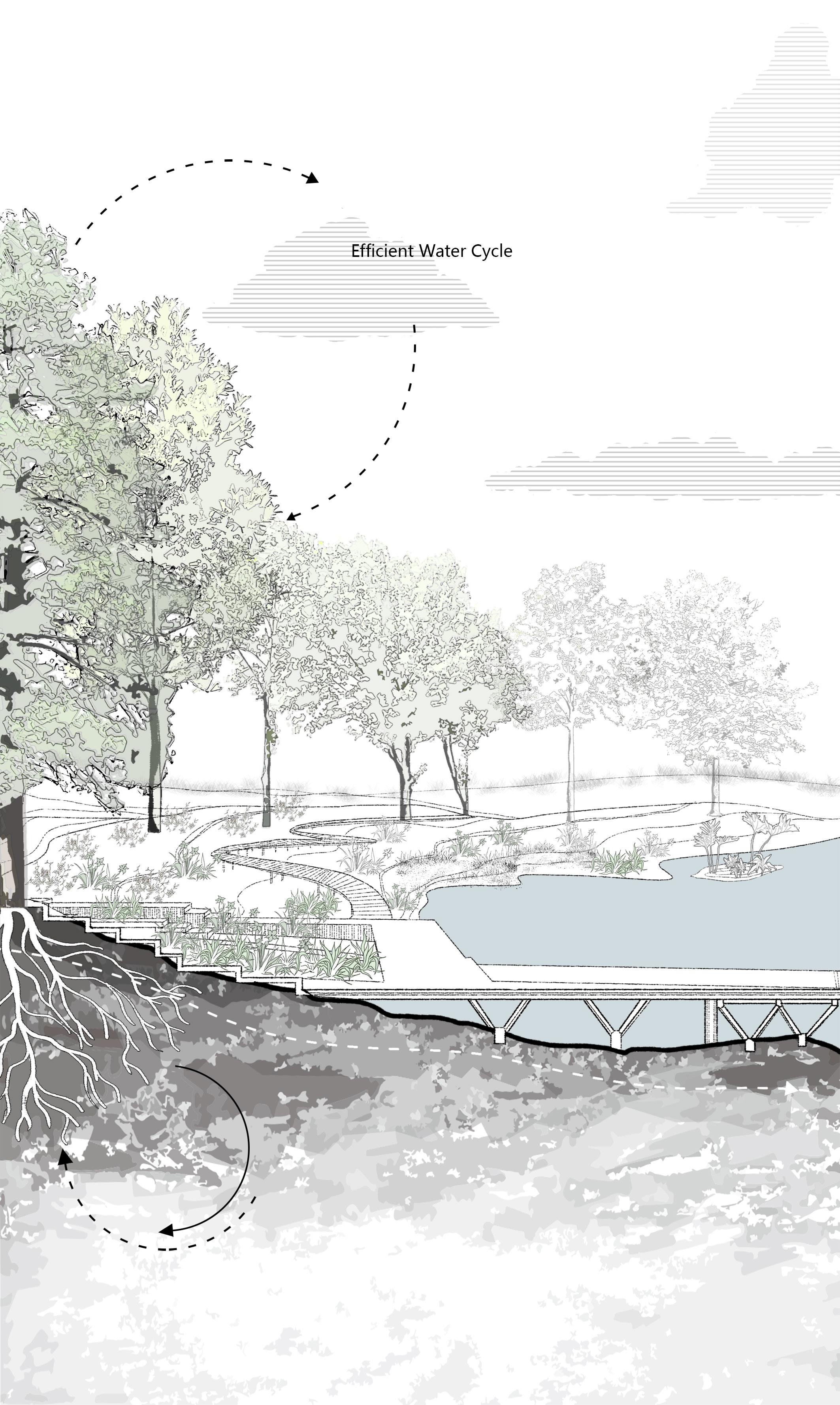
The Ogallala Aquifer, the vast underground reservoir that gives life to these fields, is disappearing. In some places, the groundwater is already gone. This is the breadbasket of America—the region that supplies at least one fifth of the total annual U.S. agricultural harvest.
The substrate of the aquifer is made up of poorly sorted and unconsolidated clay, silt, sand, and gravel deposited by streams and wind, as well as finegrained sandstone, siltstone, and interconnected fractures.
Major and minor agricultural areas combinedaccount for 99% of the total national production.
Major agricultural areas combined account for75% of the total national production.
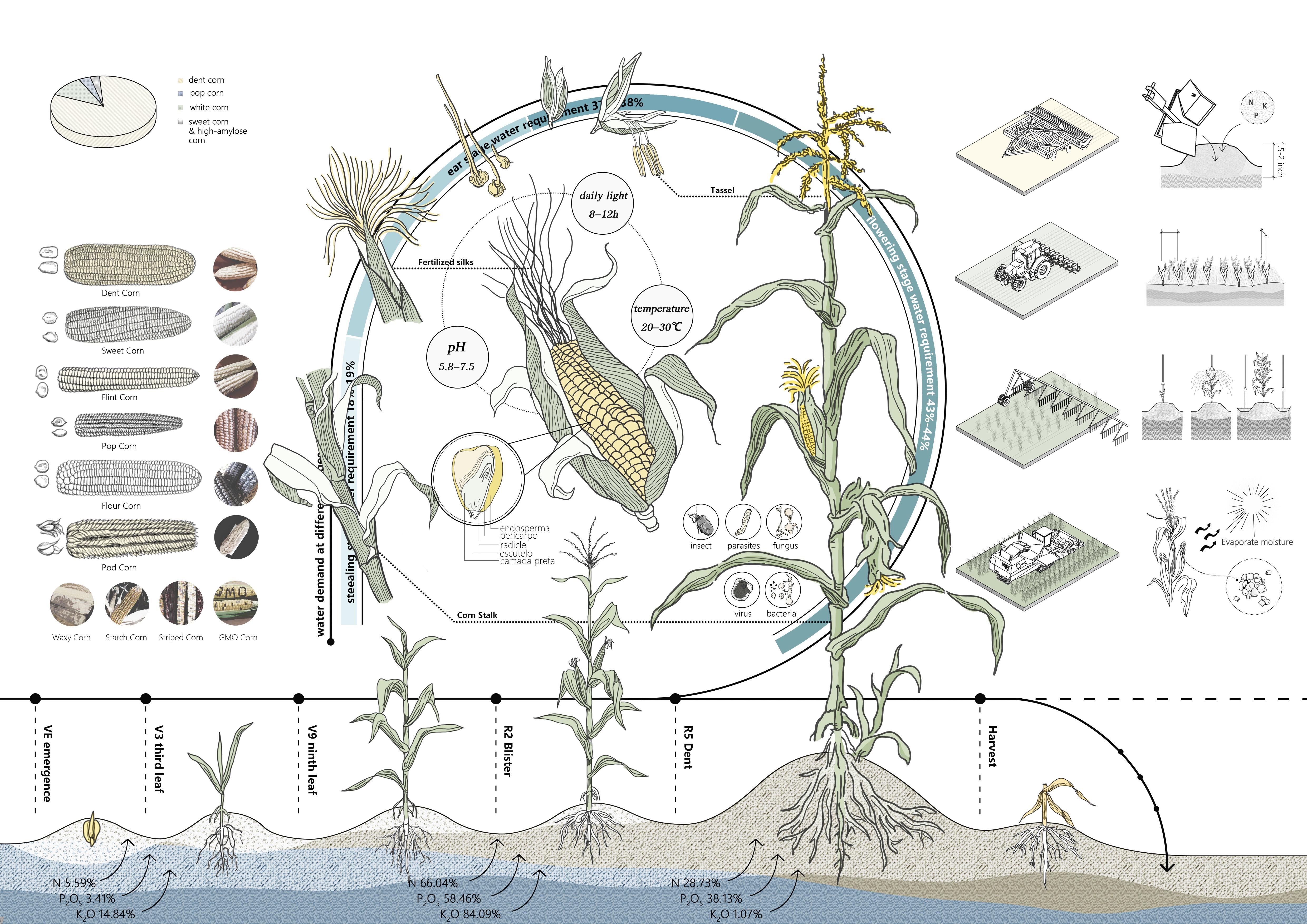
There are various types of corn in the United States, among which dent corn is widely planted because of its high yield and properties and is widely used in food, feed, etc.
The second is white corn, a subspecies mainly used for food, such as canned corn.
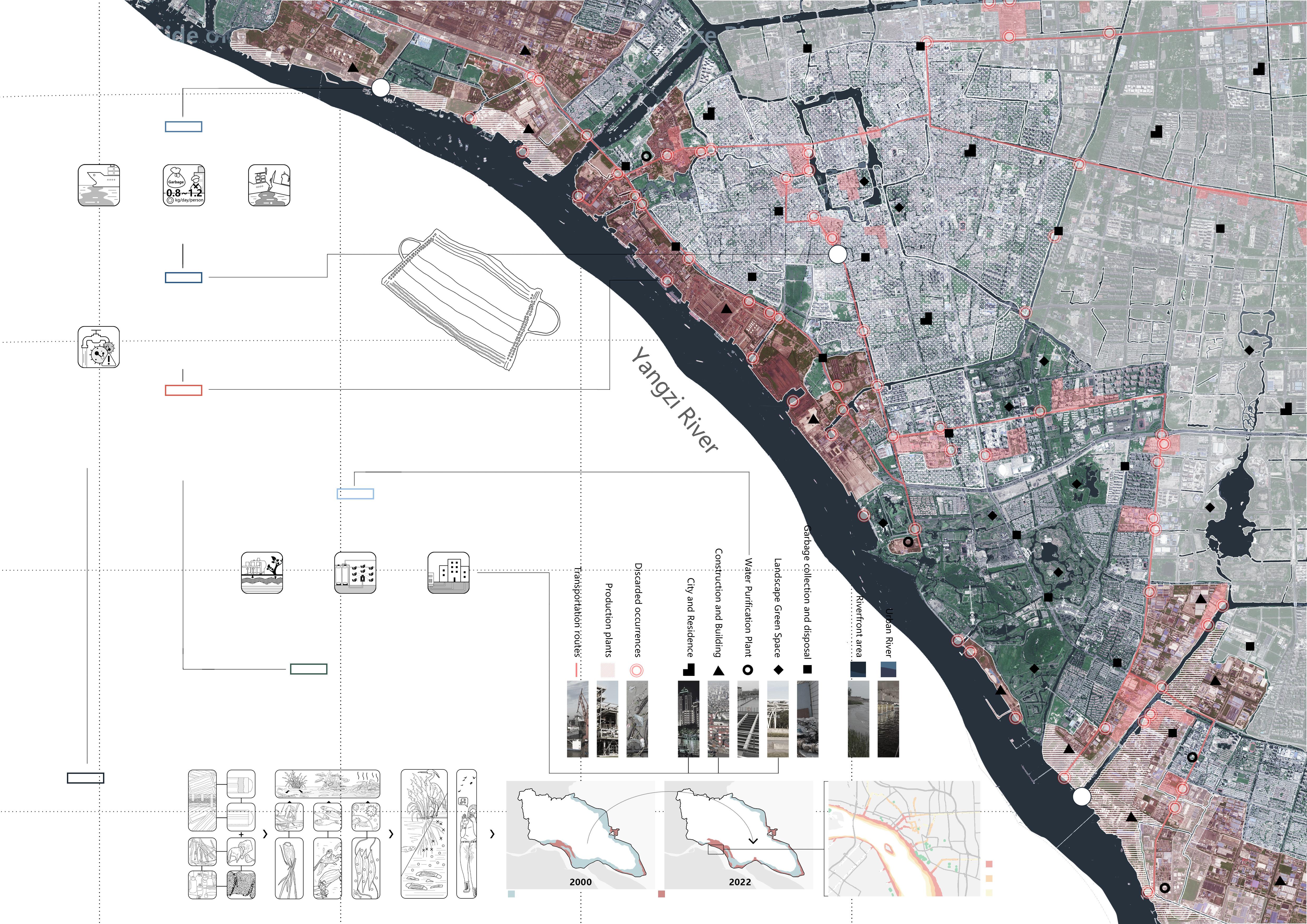
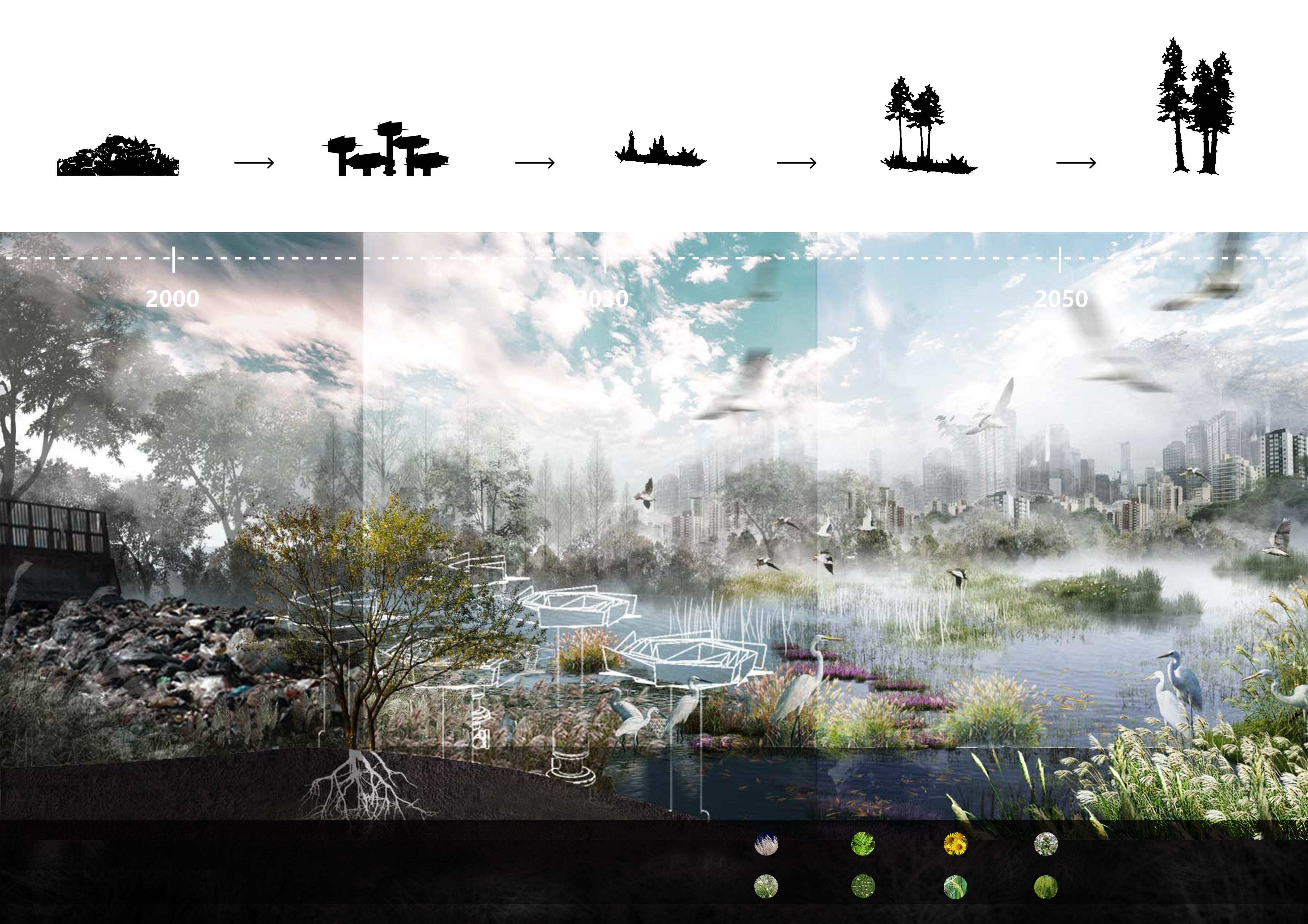
Landscape Installations and Embankment Protection Design in the Post-Pandemic Era
The widespread impact of the pandemic has significantly affected the rise and fall of related industries and the utilization of spaces. While the widespread use of masks has become prevalent, the negligence of waste recycling has led to a new wave of marine pollution.
Landscape installations and embankment protection design are crucial in the post-pandemic era, aiming to create urban spaces with human care and public health awareness. The design takes into account waste recycling under multi-stakeholder participation, economically supporting industry professionals and ensuring water protection and space utilization for the environment.
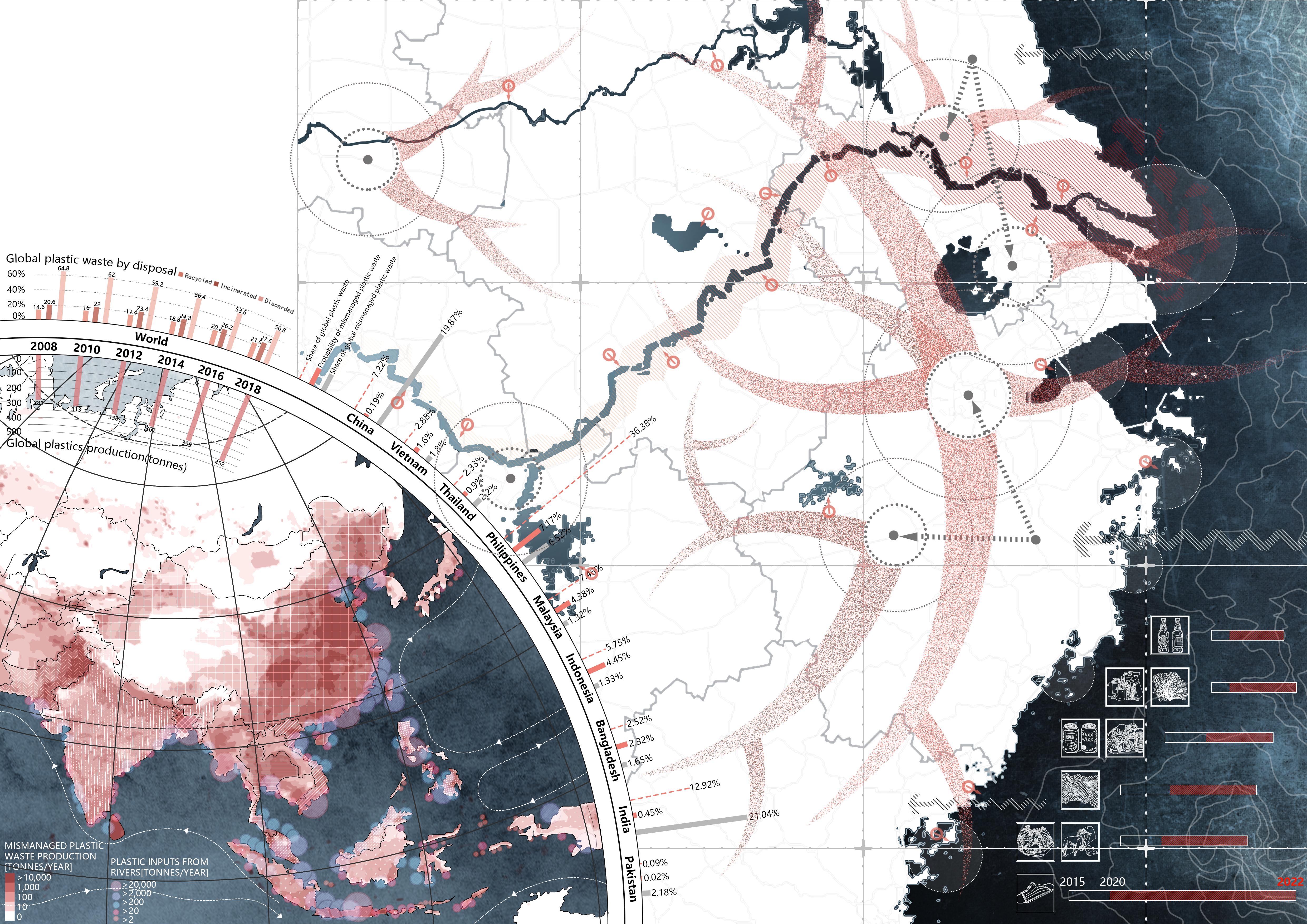
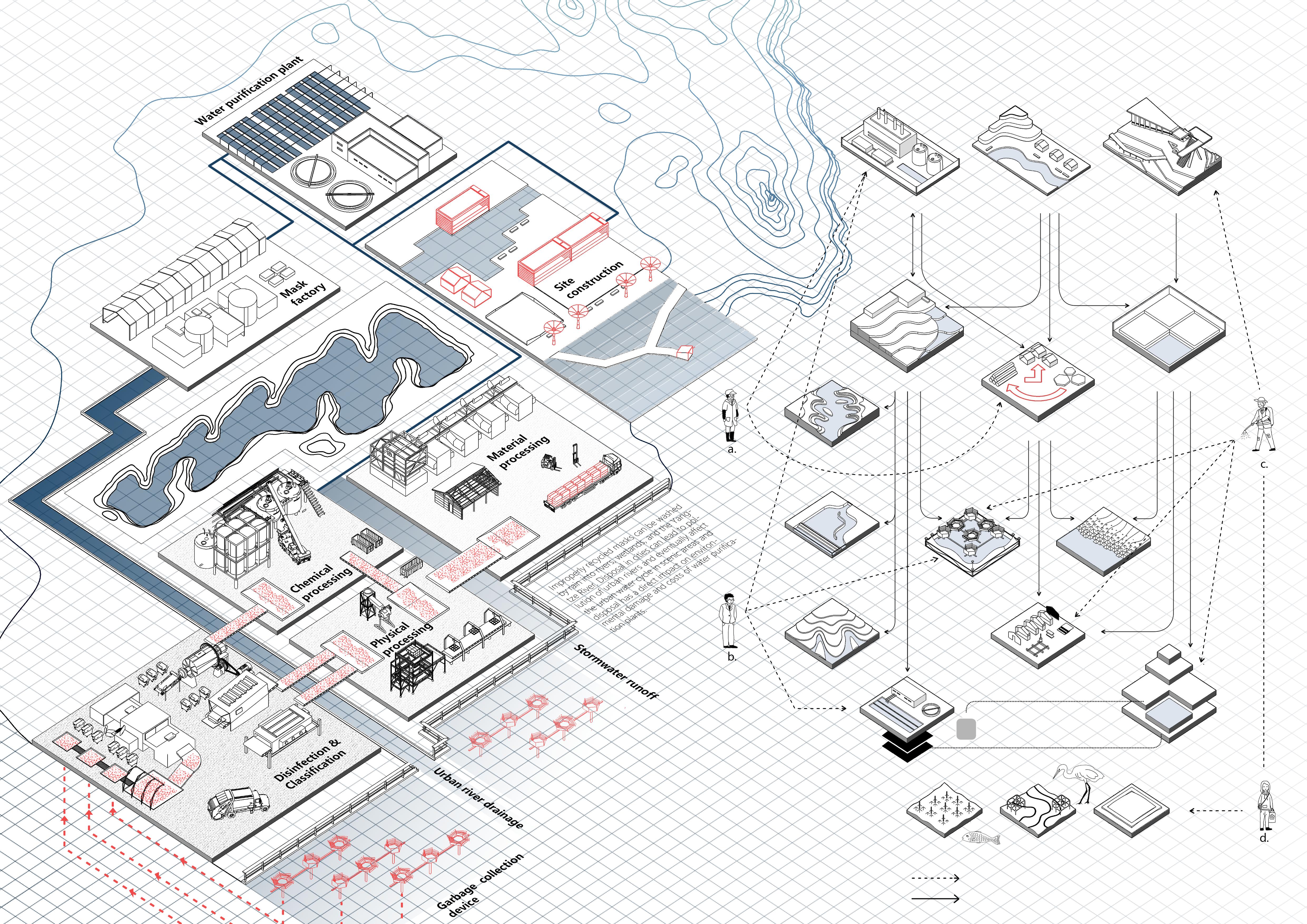
a)The use and discard behavior in scenic areas has a direct impact on environmental damage and the cost of water purification plants.
b)Disposal in cities can lead to pollution of urban rivers and eventually affect the urban water cycle.
The original site is mainly composed of three parts: the undulating terrain of the riverbank and riverbed, the artificial embankment within the retaining wall, and the naturally protected mountainous area. Possible sedimentation areas and natural embankment zones are obtained through river analysis and matrix partitioning.
Iterative Modeling of the Installation and Origami Art
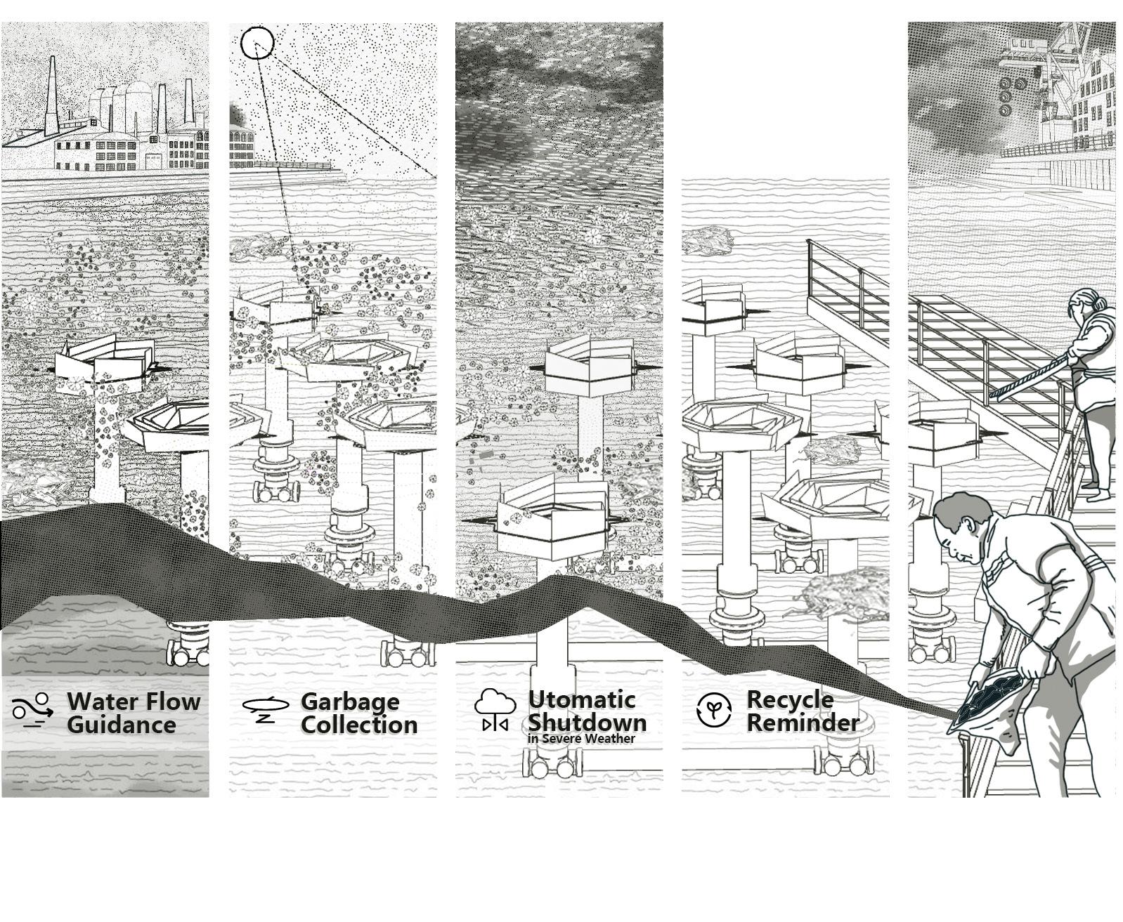
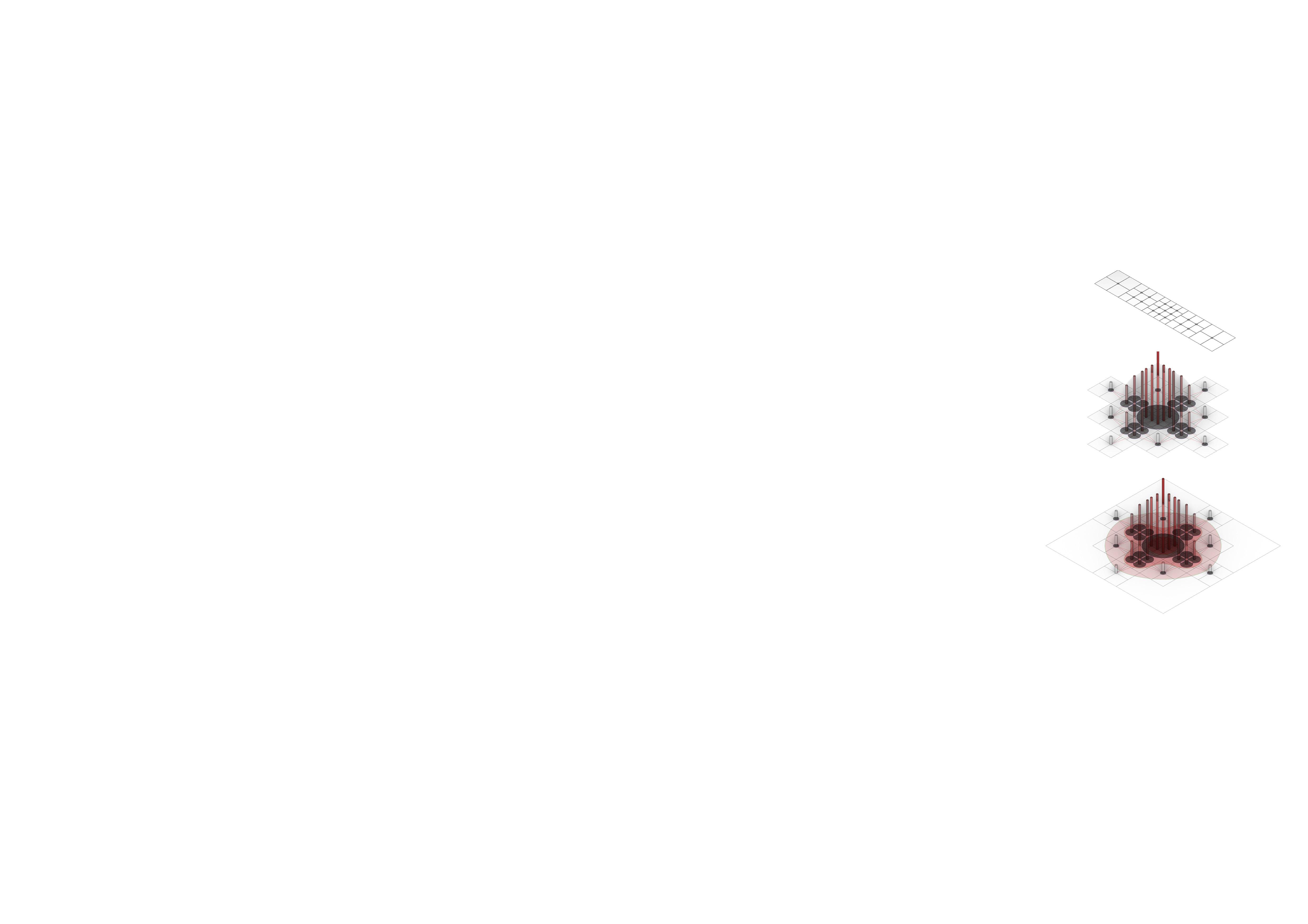
The design of the origami-inspired installation primarily takes into consideration the characteristics of non-woven fabric materials and the necessary flexibility to face the complex and changing dynamics of the river. During the deducing phase of the installation, attempts were made from multiple perspectives such as obstruction, filtration, and collection to explore the garbage collection functionality.
Functional Schematic Diagram of the Device
To cope with diverse riverbank climate changes, the installation can contract and expand based on natural information such as water flow, temperature, and height. The unfolding and retracting process enables the device to gather and intake garbage over a large area. The retrieval device is also divided into multiple parts to address different sizes and types of waterborne debris. In the event of equipment malfunction or shutdown, information is uploaded to guide personnel for repair and cleaning.
In non-tidal conditions, the designed elevation differences of the floating islands can meet the growth requirements of most plants and the formation of habitat patches. With the assistance of the device, some terrains can form floating plant islands, creating underwater habitat patches below. The design of the boardwalk ensures the process of floating island formation and the stability of the habitat both structurally and functionally. Light-sensitive resin model printing and terrain analysis
By simulating the processes of water flow and sedimentation, various types and layouts of floating islands were obtained. These were then grouped using a radial grid, generating the shapes of the floating islands. The natural sedimentation simulation was employed to determine the forms and elevation variations of the floating islands.
The design of the natural revetment on the outer side of the floodwall and the existing topography have impacted the formation of the matrix and the terrain morphology. The resulting semi-circular revetment plays a crucial role in buffering water erosion and retaining natural sedimentation.
Cross-Sectional Map
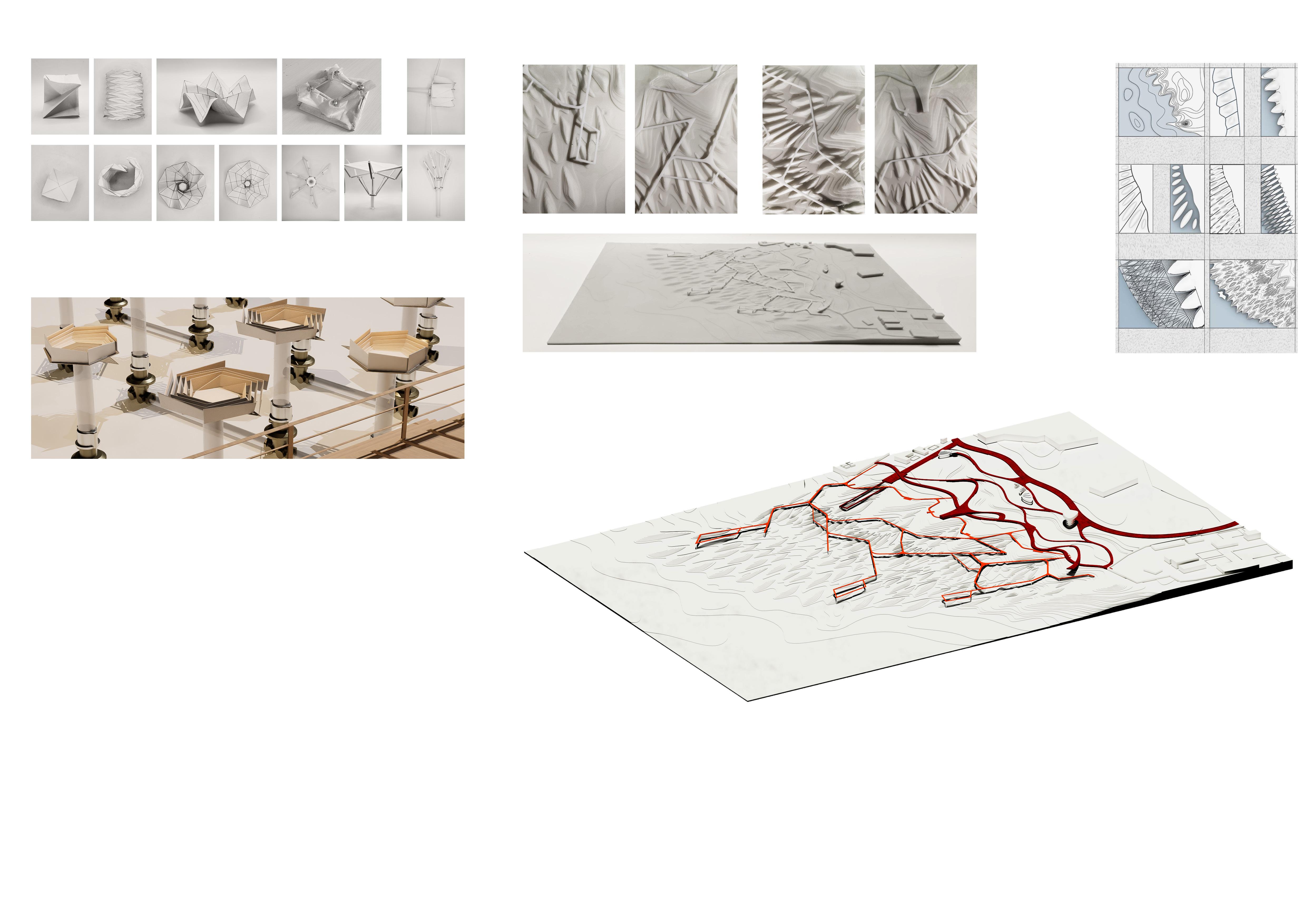
Formation of natural embankments
Based on the grid, terrain accumulation is implemented. Simultaneously, the installation arrangement increases the roughness of the riverbank flow, directing floating debris towards garbage collection nodes or being intercepted by plant islands for garbage retrieval. The arrangement of the walkways, utilizing the wool algorithm, enhances retrieval efficiency and pedestrian coverage. Additionally, it creates diverse landscape spaces and experiences by leveraging different elevations and depths. The water circulation of the Yangtze River and the rivers within the site is preserved and utilized, forming a multi-level and rich ecological community of plants. As such, when the river brings floating debris into the site, the water loses energy, causing transported items to move downstream. These floating objects and heavier items in the water flow are intercepted and deposited into the riverbed. This process promotes the formation of natural embankments through the collection of debris and the enrichment of natural materials.
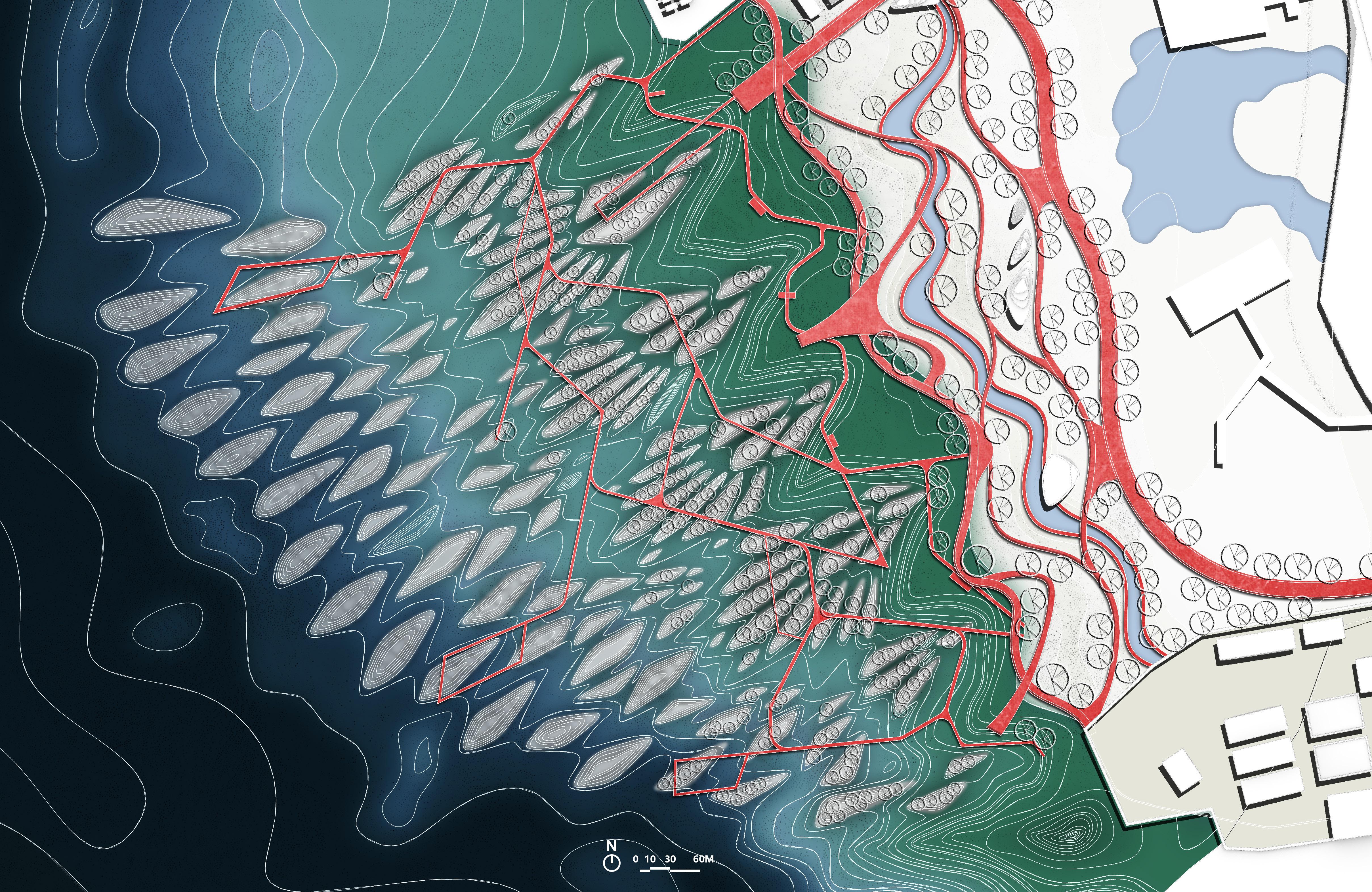
The expansive riverbank provides opportunities for various activities and is divided into four main areas: the activity zone on the inside of the floodwall, the activity zone on the natural revetment on the outside, the scenic boardwalk viewing area, and the waste retention and collection area. These four areas are interconnected by roads and vegetation. Based on water purification, diverse participation brings possibilities for education, sustainability, maintenance, and artistic appreciation to different zones.
Layout Design of the Device Group
By integrating the sedimentation process and water flow guidance, the layout of the device combination is optimized to efficiently collect garbage and accumulate natural sediment deposits.
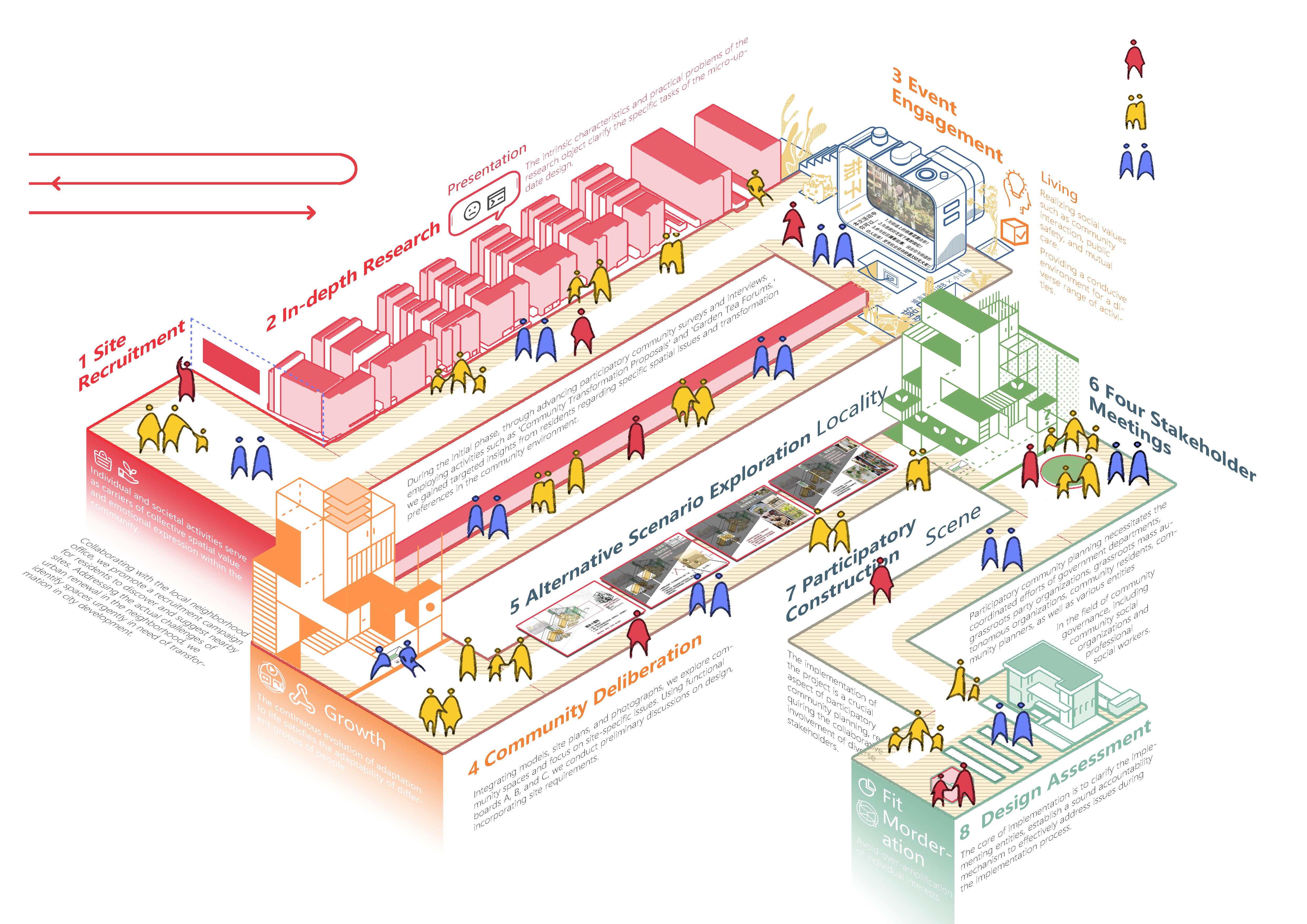
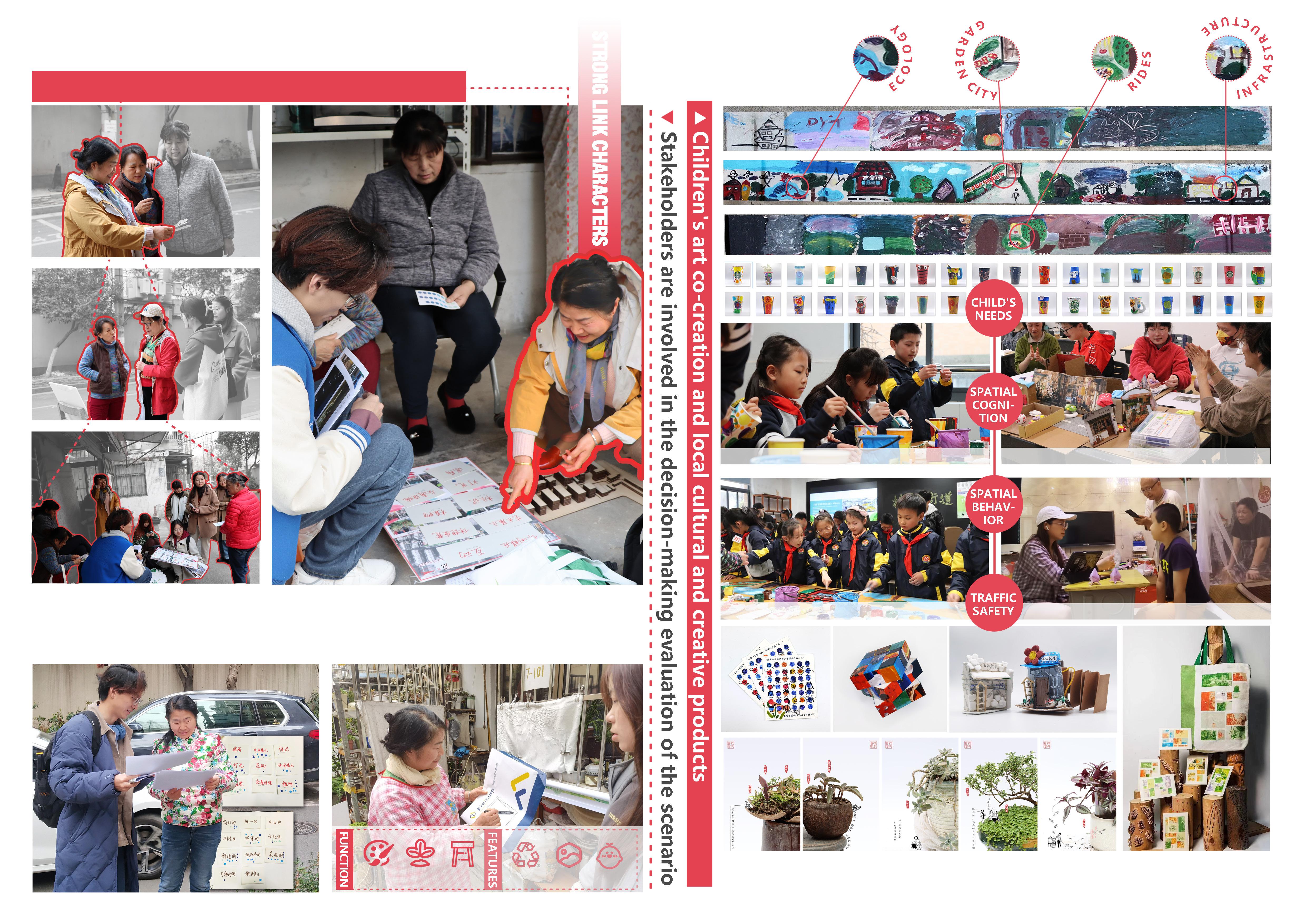
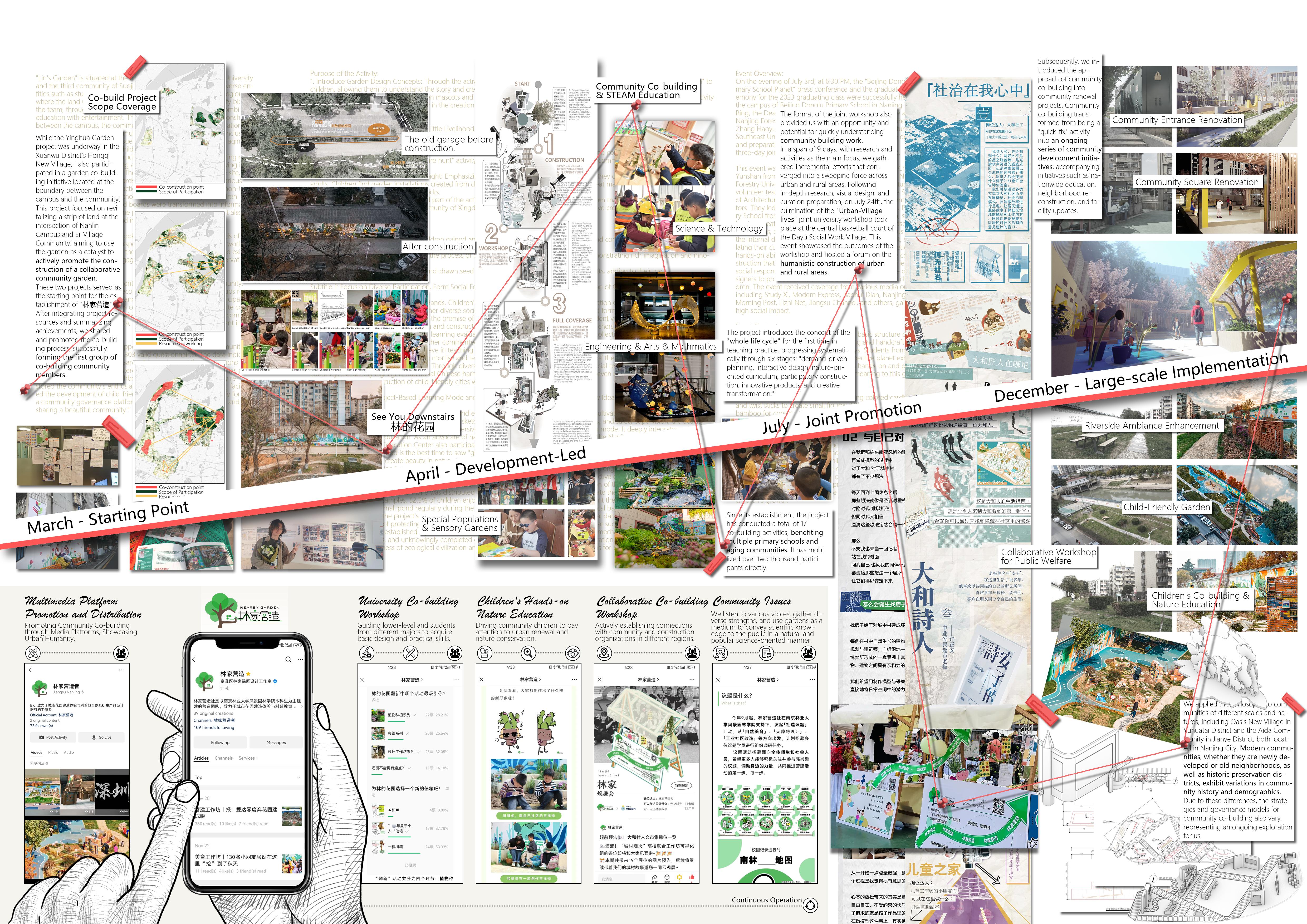
The project, rooted in human-centric demands, employs multi-solution planning and design strategy for the community participatory renewal of the Meiyuan Xin Cun neighborhood in Xuanwu District, Nanjing. It involves various stakeholders, including community residents, property management, and government officials.
Throughout multiple stages of project development, diverse public activities are organized to engage the community actively. With the integration of creative landscape and product design, the project aims to infuse new vitality into the community.
Moreover, as landscape design students, we actively explore and research the possibilities of urban renewal student practices through hands-on experience, focusing on the synergy between universities and communities.
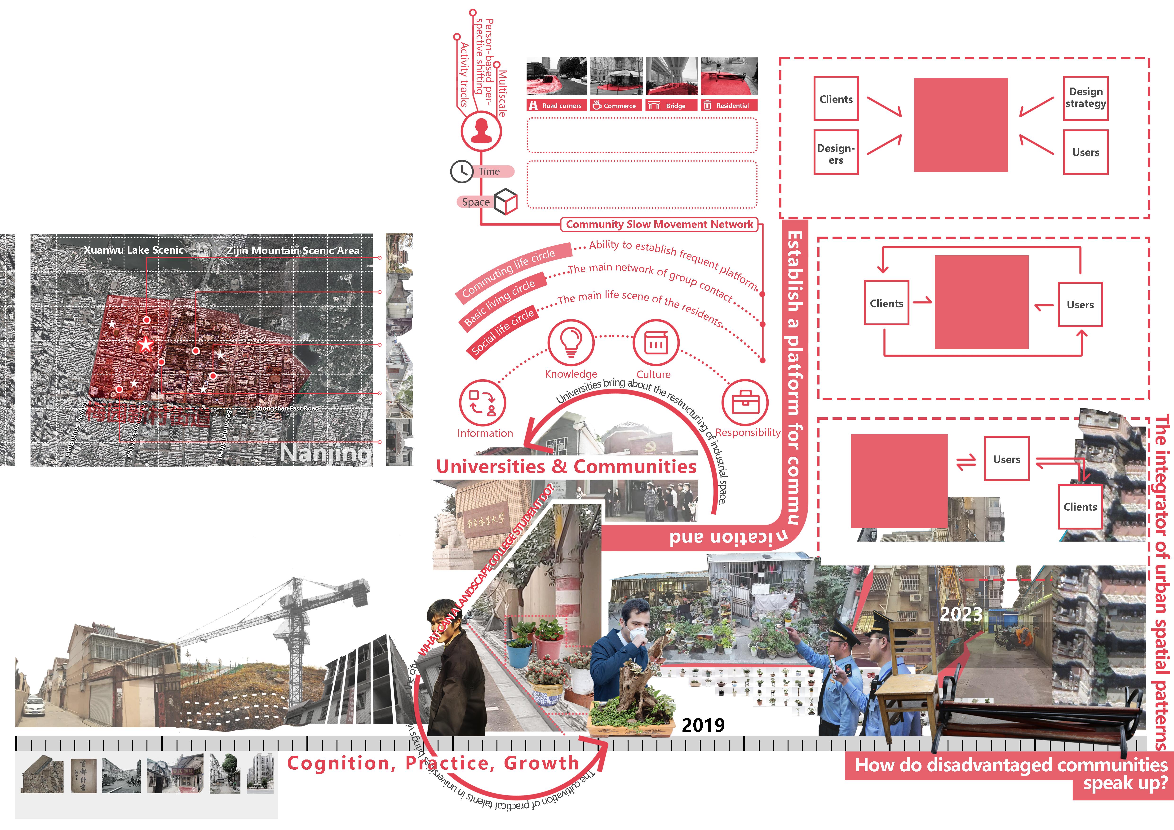
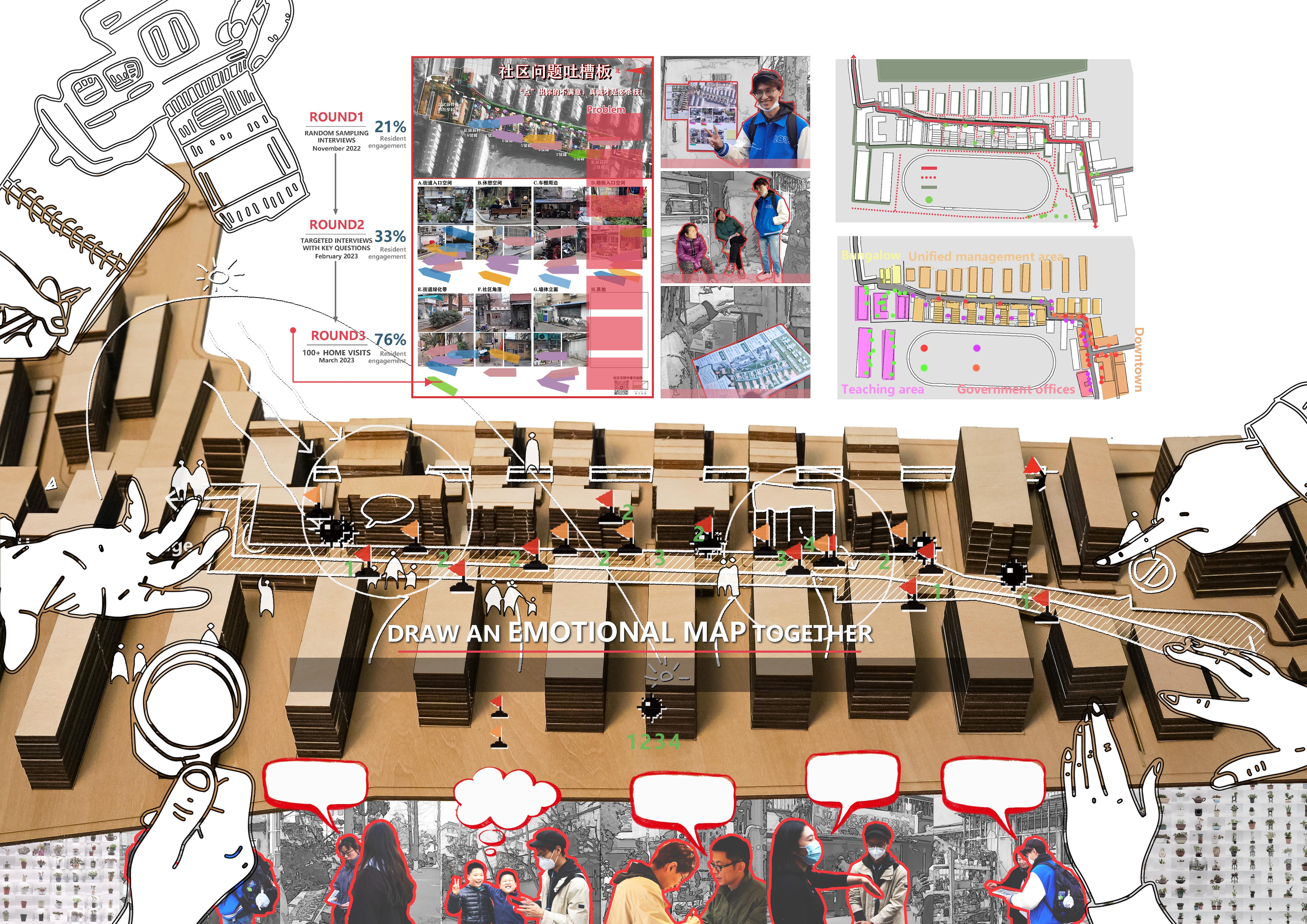
Through research and visits to Nanjing's old communities, conflicts and contradictions between renovation construction and residents' preferences were identified. Using long-term observation and research as a starting point, the aim is to guide residents to actively engage in thinking and designing their community.
This approach seeks to create positive community space that aligns with the interests of various parties, revitalizing the renewal dynamics of the aging neighborhoods.
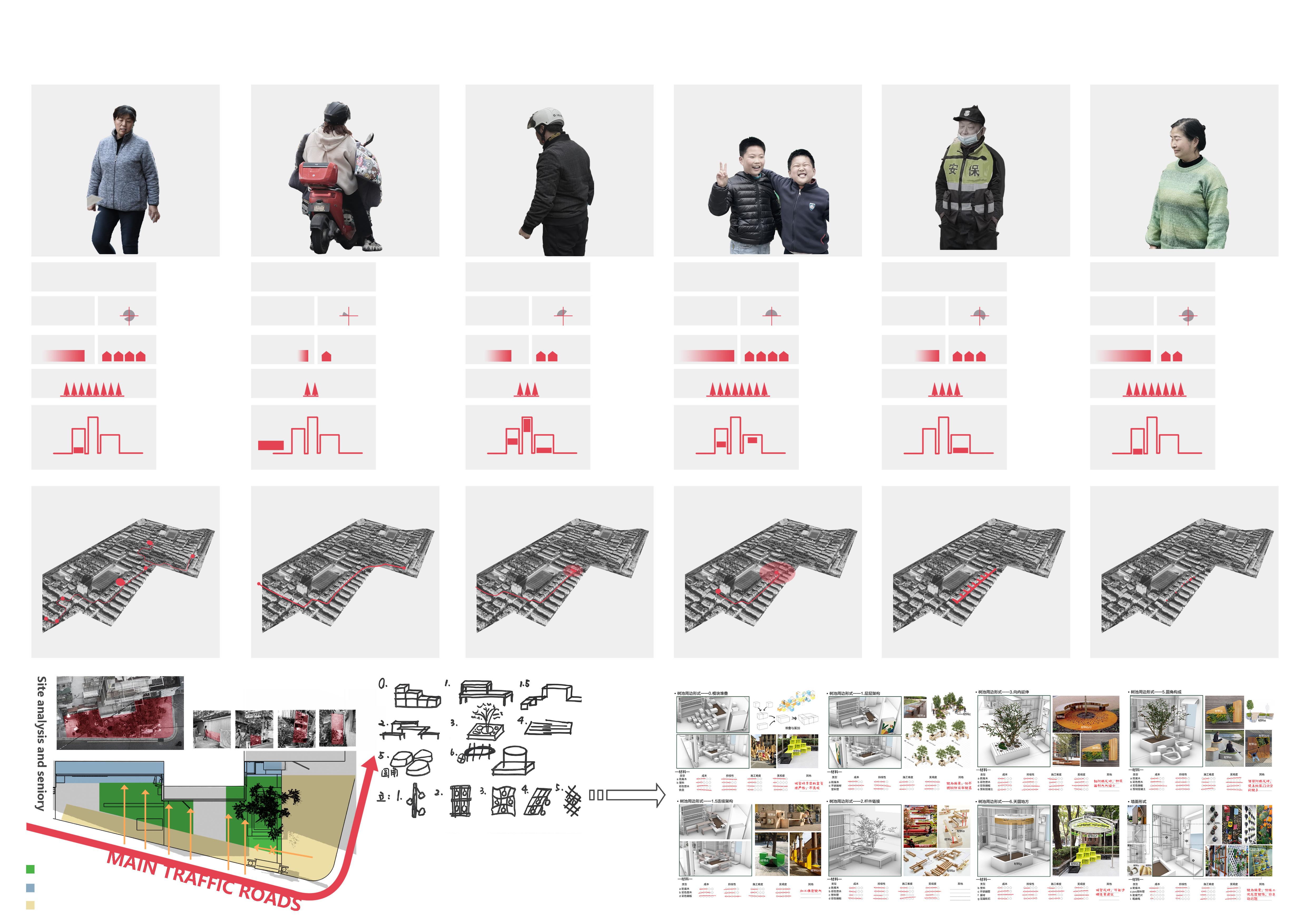
The residents' bottom-up greening behavior and disputes over space represent conflicts among different residents and between residents and the functions and rules of the site. The issues reflected in the nodes revolve around the contradiction between mature urban order and immature urban systems.
1980s
Hongqi New Village belongs to the initial construction scope of Nanjing after the reform and opening up,
Due
Human Bird Relationship Silhouette
Scenario Analysis

for
and shelter
and
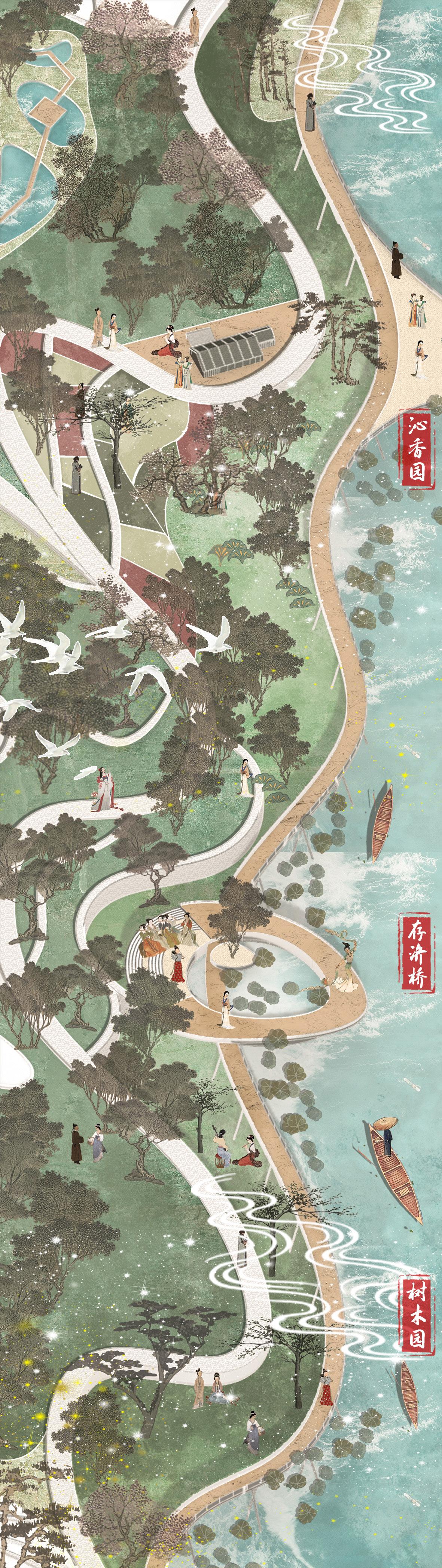
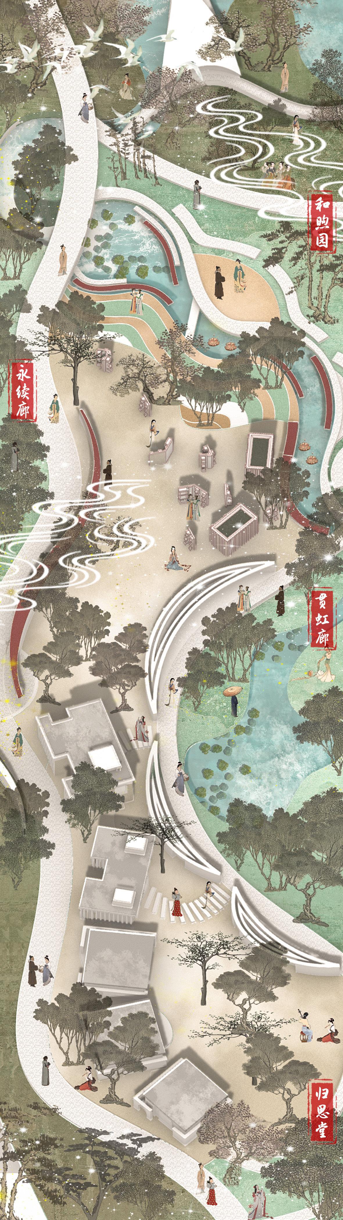
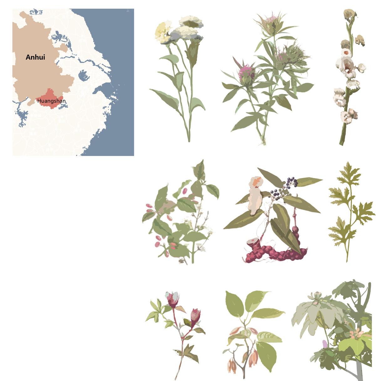
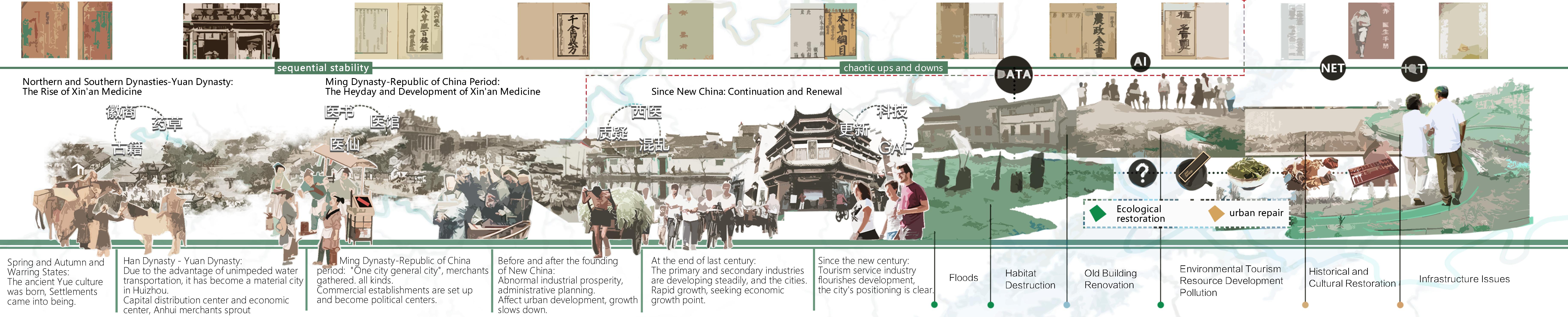
Temporal and Narrative Planning Design of Xin'an River Botanical Garden under the Urban Dual Repair Concept
In the fast-paced era of globalization, the Xin'an River Basin in Anhui Province faces challenges like flood disasters and ecological degradation.
This proposal, situated on an 8-hectare site in the Xin'an River's south bank riverside park, addresses environmental issues through urban dual improvement. The strategy involves water ecological restoration and urban cultural supplementation. By delving into Xin'an medicine culture and traditional Chinese herbal roots, the proposal aims to enhance the narrative landscape of the Xin'an River Medicinal Plant Garden. The design weaves together past and present, using the riverside space as a storytelling medium, fostering humanistic spirit, and allowing visitors to experience the charm of traditional culture.
Anhui Province is a central province in China with rich traditional culture of traditional Chinese herbal medicine. The province has diverse geographical environments and a suitable climate for the growth of various herbal plants, making it abundant in traditional Chinese medicinal resources.
For example, herbs like Scutellaria baicalensis (Skullcap), Lonicera japonica (Honeysuckle) are widely used in traditional Chinese medicine for various health benefits, including body regulation and disease treatment.
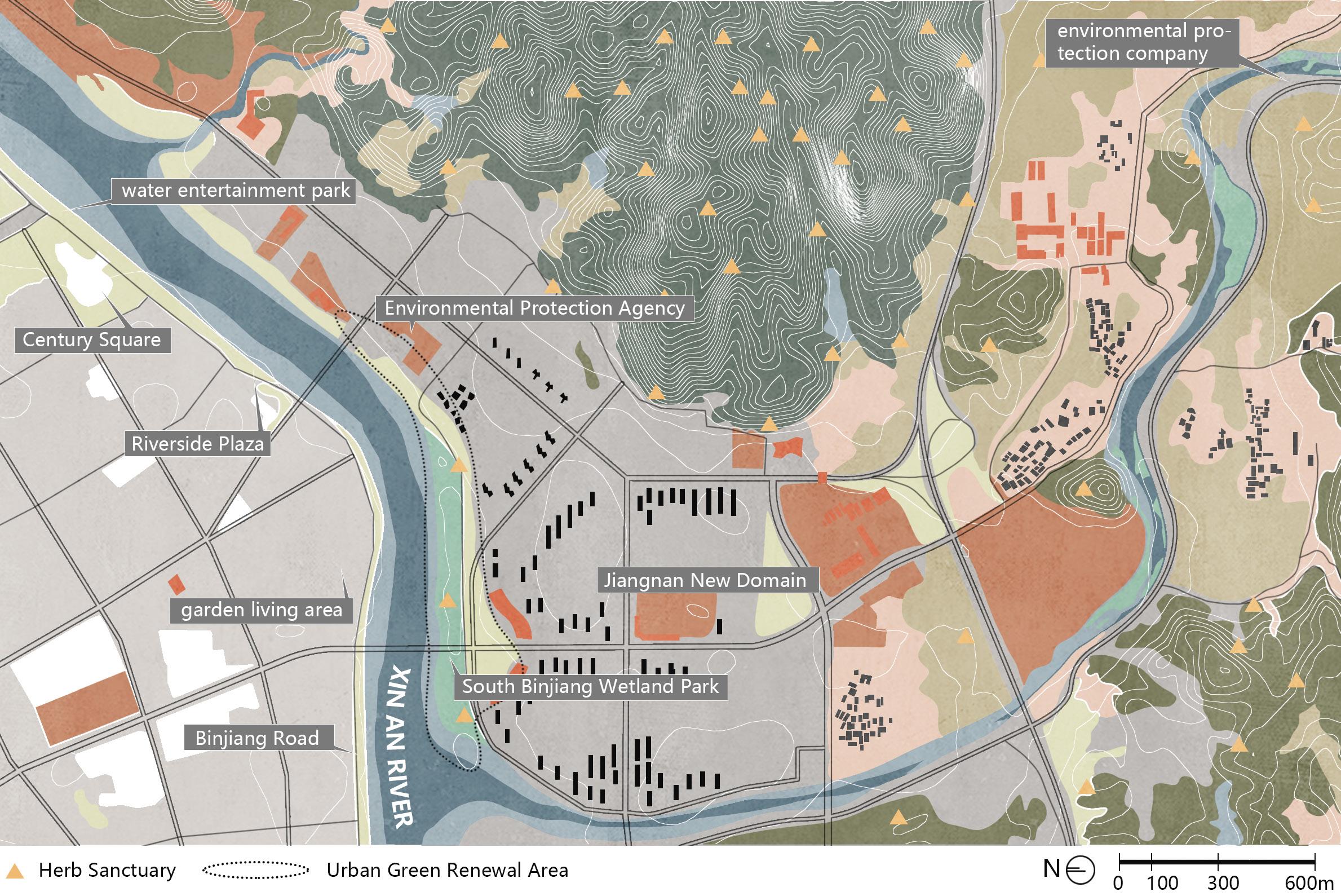
This project aims to create a linear green space that seamlessly integrates education, leisure, and interactive experiences within the context of medical culture. Through thoughtful circulation design, visitors navigate various nodes, exploring the history, present, and future of medical culture.
Beginning at Qihuang Plaza and Micro-terrain Garden, visitors enter a space rich in medical ambiance. Qihuang Plaza showcases the history of medicinal herbs, while the Micro-terrain Garden presents the pristine beauty of nature, inviting reflection on the intersection of medicine and the natural world.
Continuing along the main circulation line, visitors reach Qingnang Garden, an immersive rockery medicinal herb paradise representing the peak of medical culture. Huqingyutang from the Qing Dynasty stands as a centerpiece, embodying the traditional Chinese medicine culture of ancient pharmacies.
Moving forward, Xinglin Zone embodies the spirit of doctors, featuring facilities like Zhanxing, Nuanxiangyuan, and Yushiyuan illustrating various aspects of medical practice. This zone provides visitors with a comprehensive experience of medical practices.
Lastly, Xuanhu Zone, featuring Xuanhu Plaza, symbolizes the medical practitioner "carrying the gourd." Cunji Garden and Yuhu Lawn allow visitors to sense the hardships of doctors in unfamiliar places.
Digital exhibitions and interactive gardens provide insights into the continuity and innovation of medical practices.
In conclusion, this project, with its well-designed circulation and spatial planning, establishes site with rich cultural significance. This linear green space serves as a vital platform for the inheritance and exhibition of medical culture.