|Seletive Works From 2014-2021|
Portfolio
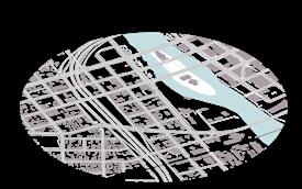
/See Greatness from Trivialness. Xinman Liu


Detroit, MI
2018 TEN x TEN Studio
Team: MASS Design Group
Wade Trim, Local Projects, HR&A Advisers, DMET Design, Craig Wilkins, Atelier Ten
Client: Detroit Institute of Arts, Midtown Detroit Inc.
Status: Complete, International Finalist
*Only Selective Works Included
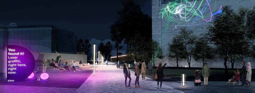
This unique opportunity to re-imagine an entire urban neighborhood is an occasion to unearth and define what always was and jettison what need not remain. This cluster of institutions have the location and reputations to be a magnetic center that reflects the energy of the whole city. The wealth of resources, infrastructure and intent is abundant; however, it is the distribution of and access to this wealth that needs to be addressed.
This proposal breaks down barriers, physical and perceived. Through bold moves to dismantle existing divisive infrastructure, we can create an infrastructure that unites. By turning the buildings inside out, we can connect existing assets to new exterior programming that fosters collaboration, activates the site, and offers opportunities found nowhere else in Detroit. Through the creation of sensory gardens, we provide a ground that awakens the senses and inspires curiosity.
remove divisive infrastructure unite pedestrian-friendly shared ground bring the institutions outside create a new circulation to journey, circumnavigate, pause and explore


Falcon Heights, MN
2019 TEN x TEN Studio
4RM+ULA Architects


TEN X TEN Studio (Satoko Muratake, Ross Altheimer )
*Only Selective Works Included
*All Graphics used are rendered or sketch by Xinman Liu.
*Photo Credit-TEN X TEN Studio +Philando Castile Peace Garden
Philando Castile devoted his life to providing food and kindness to children at JJ Hill elementary school where he worked. On July 6, 2016, he was killed in a police-involved shooting on Larpenteur Avenue in Falcon Heights, Minnesota, just west of the north entrance to the Minnesota State Fairgrounds.
In response to this tragedy, Philando Castile’s family, community members and local organizations including the Saint Paul & Minnesota Foundation have developed the vision for a contemplative gathering space for peace, justice and healing built around winding paths, gardens and places to sit and reflect.

The Community Peace Garden has been designed to feature and preserve art pieces created and placed there by community members in the wake of Philando Castile’s tragic death, and to allow families and community members, law enforcement, and local, state, national and international leaders to join together in the search for peace and justice.
EVENT TIMELINE


ALTERNATIVE TEMPORARY GARDEN IMPLEMENTATION +

COLLECTIVE COMMUNITY EFFORT

PLACE FOR REMEBERANCE + ACTIVISM


RENAME OF THE STREET + GROUNDBREAKING


Nanning, Guangxi, China


2020-2021 Personal Project
*Only Selective Works Included
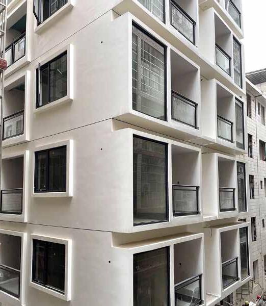
*All Graphics used are rendered or sketch by Xinman Liu. Provide architectural design and construction consulting services for a remodeling project located at LangDong urban village adjacent to the central business district. Remodel aimed providing affordable but decent living space for young professionals who work in the CBD by transform the old urban village apartment building into a gated, furnished, and wellfacilitated modern-style apartment building. The rents per unit increased by 60%-75% after the remodel


Team: TEN x TEN, Snow Kreilich Architects, Elan Design Lab, Meyer Borgman Johnson, Major Mechanical, Collins Electric, Weis Builders, TM Light, Marx|Okubo Associates, New History Consultants, Serigraphics, Summit
Client: Solaris Redevelopment
Status: Completed in 2020
*Photo Credit-TEN X TEN Studio + VONDELINDE
SECOND + SECOND, a new North Loop mixed-use development by Solaris Redevelopment Corp. and Weis Builders, broke ground on a set of large surface parking lots in July 2018. When complete, the property will house 156 residential units and approximately 22,670 square feet of commercial space. The gray brick and metal clad building will be a minimalist and restrained structure that pays subtle tribute to the North Loop’s industrial past.
The landscape approach for the project is similarly responsive to the site’s history and its remnant work yard past, recalling stacks of timbers and piles of ingots that fed the brass and aluminum foundry in the new proposed design features. The character of the existing site had a material grittiness and a “wildness” full of emergent vegetation. At street level, a “pedestrian portal” or walkway, connects N 2nd St to a courtyard in the middle of the block, creating an intimate and human-scaled experience.
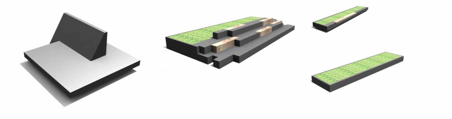

A variety of gray stone and pre-cast concrete pavers create a delicate, tactile carpet for the plaza, broken by sculpted landforms planted with lush native plantings. Custom designed pre-cast and timber furnishings create gathering nodes for a variety of group sizes.


Summer 2016
Turenscape Internship Project

Coastal land reclamation
Restoration
Teammates: Jian zhang,Yuan Xue,Xing Ming
*Only Personal works Include
The sites is located at estuary of China East Sea, it is a artificial land built from coastal land reclamation. The site is the first phase of the Wenzhou Ou River New Urban District Development and is planed to serve as communication & technology district, also included residential, commercial, recreational and educational function. The city of Wenzhou hope the new district can bring Wenzhounese back to their hometown, slow down the brain drain and attract investors and visitor come and stay.
Due to both Wenzhou's cultural and geographical remoteness and its lack of natural resources (land, minerals, etc.), the Chinese central government has left the people of Wenzhou relatively autonomous. Away from the center of the political and economic stage, its people are more independent, self-reliant, and generally more business and family oriented.
Original City Planning lack of focus
Inflexible city grid, planning was base on vehicle use, lack of Pedestrians and bike circulation and facilities


Lack of basic amenities and recreaction facilities
Loss connection with Wenzhou's local history and culture
Coastal Habitat loss due to land reclamation.
Flat topography due to land reclamation.
Straight seawall, lack of natural feature and water resiliency.
Street design was cluttered, loss city identity .
24km²
High-Tech Residential + Education
Straight River bank, lack of biodiversity.
The city itself are disconnected due to the irrational landuse planning.
Link the 3 Green Spaces and Parks in the center, create a Green Core and focus point for the city.


Introduce Gardens, urban farmings into the city ,to maximise the resilience of the eco-system through urban landscape. Blur the boundary of city and green space, create strong ecological connection, link spaces by pedestrian and bike-friendly transportation system. Create poly-centric cities, create public space for gathering, recreation, education, Comercial and bussiness use, makes The city space more compact and diverse.
Step
Encourage new building design use bottom overhead multistory construction, give back the land to public green space.

Step1. Extend river and green space toward inside of the city.
Mix-Use Community More compact city space, can meet different people's need and create more gathering space for different activities.

Before Meandered Introduce Wetland
Plants and
Water Ecology Corridor
The ecosystems are rebuild mainly through enhance the aquatic ecosystem eco-corridors that reintroducing wetland and local Riparian plants into the engineering water system, soften the stream bank, provide habitat for native wildlife while enhance the water resilient to the city.
Parks and Publick Green Space


Parks and green space are located everywhere in the city within 10 mins walkable distance. Sizes and functionality are varied depending on the context. Mainly serve as cultural and natural spaces of the town.

North Seawall Shoreline Wetland
Located at the urban ecosystem and coastal ecosystem, a great place to highlight the edge effect of the ecology. Mainly form by coastal wetland, mangrove forest and halophytes. Excellent habitat for the local/ migrating birds and very-shallow water organisms.
Street Green Space
Mainly enhancing the stormwater management function by locating biorientation basin and rain gardens along the street, on the other hand, street trees/planting provide shading for the pedestrian and lower the ground temperature of the ground.
South Seawall Windbreak
The south seawall is facing the challenging of a typhoon, plants serving as a windbreak for the city.
Water Ecology Corridor


Parks and Publick Green Space
North Seawall Shoreline Wetland
Street Green Space
South Seawall Windbreak

Diversed
Northern Seawall Ecological + Local Culture Corridor

Keywords: Bird-Watching, Productive Landscape, Fisher Folk Culture, Migratory Birds, Saltmarsh, Habitat Reclamation.
Central Urban Waterfront Social+Art+Recreation Corridor
Keywords: Public Modern Art Installation,Theater, Market, Restaurant, City Life.
Before
Before:Northern Seawall
Southern Seawall Community+Fitness+Culture+Ecological Corridor


Keywords: Local Art Installation+Outdoor Fitness, Fishing, Tidal landscape
Option#2: Art Platform
After
Terrace blend with vegetation resting/fishing spot
Option#1: Terrace

boardwalk
Option#3: Boardwald

The three waterfront spaces are design to showcase different perspectives of Wenzhou city and the Ou River urabn district. We inspired by the Chinese Scroll Painting and the ancient local painting s" Strange Fish", see the three waterfront space as three beautiful scroll paintings.Three corridors illustrate the unique local culture and history, and the present urban life, the future prospects of the new urban district.

Using Chaos Theory as Lens For Better Understanding of Urban Space Enhance Community Engagement via temporary installation


What caused the flood? According to Elwynn Taylor, State Meteorologist from Iowa S tate U nivers i ty, t h e wet spring of 2008 was traceable to relatively unusual warm and wet air over the winter. Eighty percent of moisture that falls in the Midwest is from the Gulf of Mexico, and the primary cause of it coming here is the Bermuda hig h pressure. Low pressure over New Mexico or high pressure over Bermuda are rare in winter but common in summer. Predictions in Meteorology are based on Chaos theor y , which is a mathematical method for predicting the unpredictable things and capturing the infinite complexity of nature.
Cedar Rapids, Iowa was one of the hardest hit areas during the floods of 2008. Kingston Village occupies the west bank of the Cedar River in downtown Cedar Rapids. The neighbourhood was affected by the massive flood, which caused significant damage to public and private property. After the flood, the population in Kingston Village dropped rapidly; vacant lots, unused and forgotten spaces concentrated in this community.
According to the census data, population under 20 years old makes up almost one-third (28.2%) of the Kingston Village population. There is a lack of public spaces for this age group.Low-income family structure with lower education levels, very limited access to public education and decent infrastructures set up barrier for the growth of adolescents and the community future.


Compared to the bustling downtown on the other side of the river, Kingston Village seems like it hit the “pause” button. The depression of the historical blocks is to a large extent due to the estrangement with the continuous development of its surrounding regions. Noise from factories,constructions and highways becomes harsher and louder within the underused urban spaces.
When facing such complex issues and the buried history, it was hard to make predictions and envision something precise when everything seems uncertain.


Where we should draw the first line on an empty paper was hard to decide.
Landscape architecture is a discipline that precipitates change and adaptation, Instead of creating direct connections within the physical space, Landscape Architect use temporary spaces as convergence points and test fields to give actual users a chance to engaged and shape their living environment, and create connections gradually. Provide platforms that easy for other relevant party collect data, widen public engagement, and promote inspiring action to the public in order to gain comprehensive insight and information about Kingston Village before solid design is implemented.
What caused the flood? According to Elwynn Taylor, State Meteorologist from Iowa S tate U nivers i ty, t h e wet spring of 2008 was traceable to relatively unusual warm and wet air over the winter. Eighty percent of moisture that falls in the Midwest is from the Gulf of Mexico, and the primary cause of it coming here is the Bermuda hig h pressure. Low pressure over New Mexico or high pressure over Bermuda are rare in winter but common in summer. Predictions in Meteorology are based on Chaos theor y which is a mathematical method for predicting the unpredictable things and capturing the infinite complexity of nature.
‘city planning was a problem of organized complexity, and that it should be done by starting with the particulars and observing their behavior, instead of trying to control for a single variable useful in mathematical formulas.’


 — Jane Jacobs
Nature is highly complex, and the only prediction you can make is that she is unpredictable.


The amazing unpredictability of nature is what Chaos Theory looks at.
Chaos is not something which is necessarily negative. It is the inability of human perceptions to understand the layers of a city generated by the self-organizing nature of cities.
Creates a series of vibrant, inclusive, flexible temporary public spaces that ease of transformation and active vacant or underused spaces within the community. Encouraging social interaction and bring in new opportunities for future development.Small changes and improvements can also make a huge impact on the people, society, and environment in the long term.


CITY CULTURAL+HISTORIC LIGHT SHOW
CULTURAL FOOD VENDOR+ MARKET
