
Academic& Professional
Zhaoxuan Duan
Columbia University GSAPP (New York City, NY, USA)
Master of Science in Urban Planning 23' (Expected)
Southeast University School of Architecture (Nanjing, Jiangsu, CHN)
B.Eng. in Urban and Rural Planning (5-year) 21'
Content Ⅰ. Climate Change Adaption of Neighborhoods with WRI Ross Center for Sustainable Cities China GIS Mapping, Geoprocessing, Data Cleaning Professional Shenzhen/China/2022 II. Rental Apartment Selection Based on Perception of Safety at Columbia University with Wenqi NI Data Scraping, GIS Mapping, Geoprocessing, Data Cleaning Academic New York/USA/2021 III. National Spatial Planning of Lan Cang County 2020-2035 at Southeast University with Yue WANG, Zeyan CHEN, Mingxin CHEN Urban Planning, Environmental Planning, Rural Planning, General Development Academic Lancang/China/2020 IV. Promotion of Dong Si Community with Beijing Municipal Institute of City Planning & Design Public Engagement, Survey and Mapping Professional Beijing/China/2020 ii. Design and Development of an Office Campus at Southeast University Urban Design, Real Estate Investment Analysis Academic Nanjing/China/2018 i. Renewal of a Workers' Collective Residential Compound at University of California, Berkeley Urban Theory Research, Urban Design Academic Beijing/China/2019 iii. Response to COVID-19 for a Favela at Southeast University with Yuchao ZHANG, Yue HUANG, Jing Zhang Resilient Design, Urban Design, Urban Governance Academic Rio de Janeiro/Brazil/2020 Portfolio Received Graduate School Admission iv. Response to Sea Level Rise & Urban Decline at University of California, Berkeley Resilient Design, Urban Design Academic Oakland/USA/2019
According to the Chinese Nutrition and Chronic Condition Report 2020 and Shanghai Children’s Physical Education Evaluation report, the obesity rate of Chinese citizens is rising. More than 75% of adults don’t exercise more than once a week, and ⅔ of students suggest the lack of sports equipment in neighborhoods. Meanwhile, under the context of climate change, unusual weather conditions are more and more often in urban areas, such as rainstorms and heat waves, which would decrease the possibility of citizens using sports facilities.
In this project, I joined at the very beginning and acted in the role of GIS analyst, in charge of data collecting, data cleaning, and first-stage geospatial analysis. During the geospatial analysis, I cleaned up the road network and projected the POI locations inorder to run network analysis and service area analysis.

 Caitian Village Accessibility Analysis
Mapping of all Selected Neighborhoods
Lian Hua Second Village Accessibility Analysis Huanggang Village Accessibility Analysis

Climate Change Adaption of Neighborhoods for WRI Ross Center for Sustainable Cities China during Internship under Supervision of Lu LU lu.lu@wri.org
I
Rental Apartment Selection Based on Perception of Safety at Columbia University GSAPP during 2021 Fall Semester Co-op with Wenqi NI
This research is in part a response of a recent tragic event, a street violence that resulted in the death of a Columbia student and injury of a visiting scholar. This horrifying event stirred fear and deep concerns on safety among GSAPP students, but at the same time, a sign that appeared next day at the site stating “clean up our neighborhood” revealed entrenching issues with the university and the neighborhood it is in. The research’s original intent is to query available apartment locations in Manhattan where it would be “safe” and “affordable”.
The research aims to establish a decision model to select available apartments in “safe” areas. The analysis utilizes NYPD Complaint Data Historic, a dataset that includes all valid felony, misdemeanor, and violation offenses1 reported to the New York City Police Department (NYPD) from the Jan.1.2018 to Dec.31.2020 , StreetEasy data for available studios and one bedroom apartments in Manhattan under USD 1700/Month , NYC Borough boundaries, and 2010 Neighborhood Tabulations Areas to create decision layers.


The model assumes that the offenses represented in NYPD Complaint data represent the safety condition, and a willingness to pay of 1700 USD per month for rent (30% of entry level urban planner average salary in NYC). The model also assumes a specific timeframe using data from 2018 to 2020. The weighing method assumes a multiplying relationship between offence categories1 and location types (description of premise) as illustrated in the table below.
The “Residence” category aggregates the data from three types of residency according to the dataset: “Residence-apt, house”, “Residence-public housing”, “Residence-house”, and “Other” includes all other locations included in the dataset, such as public buildings and transportation hubs. Predictability and severity of the offenses are the criteria of creating the weighing standard.
The standard assumes that street offenses is the major factor when considering selection for a “safe” place to live in as those are unpredictable offenses, followed by residence offenses and other offenses.
Kernel Density of Violation Reported
FelonyViolationMisdemeanor
Street In Residences
II
NYPD Complaint Data Historic StreetEasy.com Felony Misdemeanor Violation Street Residence Other Type of Offenses Place of Reported Aggregated Rasterized Offenses Data Kernel Density Map Scratch Studio Housing under $1700 One Bedroom Weighted Map Calculated with Weighted Scores Point Feature Classes Projection Rasterized Housing Data Rasterize Selection Map
Category Weight Street Residence Other 3 2 1 FELONY 9 27 18 9 MISDEMEANOR 3 9 6 3 VIOLATION 1 3 2 1
On
Others
A weighted score map was created, representing the offenses density according to certain criteria.
Address Price

Findings
By using Python doing data scratching and geocoding, a dataset was created which included all avalible rental houses according to certain criteria.


Weighted Score 5025 Broadway #2C $1,650 64.8 1781 Riverside Drive #2D $1,850 74.4 521 Isham Street #3B $1,700 89.6 2 Seaman Avenue #4G $1,779 93.3 2 Seaman Avenue #4I $1,700 93.3 10 Cooper Street #UNITD $1,845 94.9 10 Cooper Street #H $1,750 94.9 682 Academy Street #53 $1,800 97.2 4871 Broadway #2M $1,625 100.3 118 Post Avenue #3N $1,700 101.0 Address Price Weighted Score 101 Cooper Street #3R $1,674 87.4 116 Seaman Avenue #6C $1,970 87.5 521 Isham Street #1 $1,500 89.6 570 Isham Street #1C $1,595 89.8 30 Seaman Avenue #1 $1,675 91.3 30 Seaman Avenue #2AA $1,700 91.3 69 Cooper Street #2 $1,500 92.5 2 Seaman Avenue #5C $1,676 93.3 59 Cooper Street #2A $1,450 93.4 15 Seaman Avenue #4F $1,700 94.7
National Spatial Planning of Lan Cang County 2020-2035 at Southeast University during 2020 Spring Semester Co-op with Yue WANG, Zeyan CHEN, Mingxin CHEN
Lan Cang County, fully named Lan Cang Lahu Autonomous County, locates on the Southwest Border of China. As an underdeveloped county, Lan Cang County is seeking development with its advantage of ecological resources, such as mountains and primeval forests; cultural resources, for being the root of Lahu (also known as Musoe); location advantage, for being a neighbor of Myanmar and upstream of Mekong River. Thus, Lan Cang County is seeking a new plan for its development.
National Spatial Planning, also known as Territorial Spatial Planning, is a planning system created by the decision of the central government. It was designed to combine the various plans existing in China, including the National economic and social development plan, Major function zone planning, Land-use planning, Urban and rural planning, and Environmental protection planning. Ideally, the full system includes five levels (national, provincial, municipal, county, and township levels), three types (general planning, detailed planning, and special planning), and four systems (planning's formulation and approval system, planning's implementation and supervision system, planning's law and policy system, and planning's technical standard system).

I only included the maps of the Planning of Lan Cang, there are also a planning proceeding handbook and detailed status included in this project.
Ecological and Agricultural Planning of Lan Cang County
Current Ecology Structure Ecological and Agricultural Redline
National Spatial Divide Plan Ecological Zoning Plan


Agricultural Zoning Plan Urban Space Zoning Plan Ecological and Agricultural Plan

 General Status of Lan Cang County and the Planning
Location of Lan Cang Planning Area
General Status of Lan Cang County and the Planning
Location of Lan Cang Planning Area
III
Regional Planning of Lan Cang County
Special Planning of Lan Cang County
Spatial Planning of Lan Cang County


 Spatial Structure Concept
Regional Connection Concept Regional Ecology Concept Regional Cultural Concept Regional Transportation Concept Industrial Space Concept Heritage Space Concept Leisure Space Concept
Current Township Connection Township Connection Concept Current Transportation Transportation Plan
Current Public Service Facilities Public Sevice Plan Public Facilities Plan
Spatial Structure Concept
Regional Connection Concept Regional Ecology Concept Regional Cultural Concept Regional Transportation Concept Industrial Space Concept Heritage Space Concept Leisure Space Concept
Current Township Connection Township Connection Concept Current Transportation Transportation Plan
Current Public Service Facilities Public Sevice Plan Public Facilities Plan
General Planning of Lan Cang County Seat


Current Arrangement
 Current Land Use
Zoning Plan (Code) Red Lining Plan Zoning Plan (FAR)
Current Road Transportation Plan Community Plan
Land Use Plan
Current Zoning Environmental Evaluation Functuion Zone DivideUrban Structure Concept
Spatial Structure Concept Industrial Space Concept General Transportation Plan Facilities Plan Built Area Boundary Plan
Public Facilities Plan Water and Eco Plan Landscape Concept Scenery Concept Disaster Reduce Plan Infrastructure Plan
Current Land Use
Zoning Plan (Code) Red Lining Plan Zoning Plan (FAR)
Current Road Transportation Plan Community Plan
Land Use Plan
Current Zoning Environmental Evaluation Functuion Zone DivideUrban Structure Concept
Spatial Structure Concept Industrial Space Concept General Transportation Plan Facilities Plan Built Area Boundary Plan
Public Facilities Plan Water and Eco Plan Landscape Concept Scenery Concept Disaster Reduce Plan Infrastructure Plan
First Survey at July 20 2022
Promotion of Dong Si Community


for Beijing Municipal Institute of City Planning & Design during Internship under Supervision of Xing ZHAO


Dongsi Community is a neighborhood located closely on the Northeast side of Forbidden City, near the Wangfujing Commercial Area. As part of the original Beijing City which could date back to the Yuan Dynasty (1271AD-1368AD), the community has a lot of traditional buildings and heritages. Previously, Dongsi has been renovated before the 2008 Beijing Olympics. However, due to various reasons, the renovation was widely criticized for unloyalty to the original Beijing architectural style. Thus, a new renovation project aims to improve the living conditions and street conditions of this area was announced by Beijing Government.
The Whole project was finished at early 2021.
Reported by Beijing Daily


http://www.xinhuanet.com/house/2021-01/19/c_1126997884.htm
Public Engagement Meeting at July 27 2020
Stakeholder Meeting at Aug 18 2020
IV
Photoes During Survey Aug 2020


Comparing History Streetview and Current Streetview


 Finished Project (Photoed by Watermarked Author at 2022)
Design Portfolio for Grad School
"Everything & Design" Portfolio toward a Full Stack Urbanist
Got 2021 Admission of Columbia University GSAPP MSUP Program Cornell University AAP MRP Program
nehmen,
Renewal of a Workers' Collective Residential Compound Beijing/China


Academic & Personal A Combination of an Individual Coursework Study and an Individual Volunteer Design Advisor (of Coursework Study only): Marco Cenzatti, Tamara Kerzhner(GSI) Study was Finished in UC Berkeley at Spring, 2019 Design was Finished in Beijing at Summer, 2019
Both were Refined at Fall, 2020
Utopia, usually be described as a place of ideal perfection , especially in laws, government, and social conditions. Thus, the description of Utopia is usually considered as a reflection of the present. Specifically in the context of urban study, utopia is considered as an urbanized area in which social and spatial perfectness exists. The procedure toward the state of perfectness is so-called “Utopianism”.
Generations of urbanists put forward different but related utopianism theories, trying to build a utopia in the imperfect world with various but connected methodologies. Most of the approaches failed, but all of them affected the current urbanism deeply and thoroughly. Wherein, the utopianism practices in USSR, Eastern Europe and PRC left sufficient heritages known as Микрорайо́н (Microdistricts in Russian), and most of them are facing decaying in the post-communism era. Some of them became Slums, and even can be described as DYSTOPIAs . These legacy of the largest utopianism experiment in human history provided urbanists plenty of resources for spatial experiements throught urban renewal.
In this project I meant to illustrate a piece of phylogeny about utopianisms' development through historical nodes, and tried to deduce the logical core of their spatial design in contemporary age. Through the summary and illation, this project meant to offer a general social and spatial approach toward the renewal of the heritage. Specificically, the prototype located in a 1950s workers' residential compound in Beijing, China.
Theory & Design
Preface
1 2 2 2
to

Link-up 1: a Sample of Existing Former "Utopias"


Link-up 2: Timeline Study of the Sample: Jiuxianqiao, Beijing, China Link-up 3: Sample Critics
Part 2. Reform Proposal: "Conter-Dystopia"


VIII Urban
Part 1. Historical Research Abstract Introduction From Books
Experiments To the East, To the Far East Bibliography
2 4 6 7 7 8 9
Neo-UtopiaUtopianism→Heterotopianism =lim(Conter-dystopia) An Experiment: "Die Arbeiter haben kein Vaterland. Man kann ihnen nicht
was sie nicht haben." ——Manifest der Kommunistischen Partei Content
Part 1 Historical Research
Building a Secular Utopia: the Evolution of Utopianism
Abstract
Utopia, an enclosure of social and spatial perfection, is also related to the reflection of the present. As the procedure towards utopia, utopianism has witnessed generations of thinkers’ social and spatial theories and experiments. This essay aims to trace the phylogeny of utopianism through six important historical nodes. By analyzing the differences and similarities, this essay endeavors to explore the core of utopianism and form a better understanding. First, utopianism embodies the shift in technology advancement and social conflict in every era. Second, utopianism aims to establish a social and spatial homogeneity, avoiding challenging factors such as inner polarization and outer impact that break up the harmony.
The phylogeny research included following historical nodes:

Thomas More’s book of Utopia (1516)

Utopian socialists’ theories and practices (late 18th and early 19th century)

Karl Marx's Communist Manifesto (1848)
Urban theories and urbanization practices in USSR (1920s-1930s)
Utopianism practices in Eastern Europe and PRC (1950s-1990s)
the present echo of utopianism: gated communities in China (1990s-now)
Introduction: a Long-lasting Dream
Today, rather high portion of urban residents of Communist states (past and present) still live in old collective compounds known as microdistricts . After the worldwidely downfall of Communist regimes, some countries chose decommunization, which includes the deconstruction of microdistricts.

Most of these compounds were built before 1980s, and suffering from various problems caused by urban decay: population decreasing, public security deteriorating, infranstructure aging, etc.. Thus, the urban renewal of these compounds is necessary and urgent. However, instead of simply demolishing these compunds and building high-risers, I believe the urban renewal should respect the urban context and genius loci. For instance, having a condo in an isolated, fully functioned urban/suburban Xiaoqu (modernized microdistricts) was still most Chinese people’s dream, which is a symbol of civilized and stable. The microdistrict's influence on people's mind is deep and through.
Moreover, The excisting microdistricts formed various cities' urban fabric, and sometimes even urban residents' lifestyle. Most of the residents were workers who worked for national factories for their entire life. The urban renewal process should consider the logic behind the generation of thus urban texture and spatial hierarchy. The methodology leads to following questions: How was the design of microdistrict proposed? How did communism influence or even decide urban space? What are the historical, social and spatial reasons? Is communism's spatial control a coincidence or inevitable? To answer these questions, this essay traced back to the outset of Utopianism: the book of Utopia.
From Books to Experiments: Utopia, Utopian Socialism and Communist Manifesto
Utopia
At 15th century, Self-cultivators and tenants in Britain lost their land in countryside due to the enclosure movement: The nobles and gentries took the land of farmers away and changed the farmland into grassland in order to feed the sheep for wool industry. The medieval British countryside’s homogeneous spatial structure (formed by self-cultivators and tenants’ small pieces of land) and social structure (one landlord ruled several tenants) were destroyed.
Heterogeneity invaded the peaceful idyll countryside: there were a class of people who no longer belonged to the long-lasting social structure. On the other hand, the accompanying spatial structure change brought even more heterogeneity, in other word, conflict. The rural area was formed by two different components: the enormous rangeland and the small tenant-owned fields.
Thus, at the year of 1516, the book Utopia came out. by which your sheep, which are naturally mild, and easily kept in order, may be said now to devour men and unpeople, not only villages, but towns; for wherever it is found that the sheep of any soil yield a softer and richer wool than ordinary, there the nobility and gentry, and even those holy men, the dobots! not contented with the old rents which their farms yielded, nor thinking it enough that they, living at their ease, do no good to the public, resolve to do it hurt instead of good.1
1. Utopia, Thomas More, 1516 A Comparision between Old Town and Microdistrict in China which Showed the Unique Urban Fabiric by Beijing Municipal Commission of Planning Portrait of Sir Thomas More, English humanist and statesman, Chancellor of England By Hans Holbein the Younger, 1527; in the Frick Collection, New York City Peiping (Beijing) 1945 Beijing 1956An Experiment Renewal Workers' Residential Compound 3
"Same with same"
Fractal Art of Utopia, Drawed by Author
Fractal: noun. a curve or geometrical figure, each part of which has the same statistical character as the whole.
Through these word, we could tell that More showed great discontent to the happening shift. He criticized the newly-formed capitalism social and spatial structure, and offered a blueprint through a book of fictional literature.
Photography of Micheal Foucault, a post-modernist
https://www.rfi.fr/cn
Foucault used the metaphor of human body to describe the features of utopia: …Utopia is a place outside all places, but it is a place where I will have a body without body, a body that will be beautiful, limpid, transparent, luminous, speedy, colossal in its power, infinite in its duration...There is also a utopia made of erasing bodies. This utopia is the land of the dead, those grand utopian cities that the Egyptian civilizations left behind…The mummy is the great utopian body that persists across time…1

Features Summary of Utopia
-Limited Scale
Limited population in every city would make the country perfectly centralized and it could ensure the social control came directly from central goWvernement to keep the social homogeneity.
-Isolation
It was an unknown island which was difficult to reach: which meant the outsider could not enter as well as the residents could not leave. “The channel is known only to the natives; so that if any stranger should enter into the bay without one of their pilots, he would run great danger of shipwreck.”2
-Equality
In the Utopia, there were no upper-classes and no lower-classes due to public-ownership, thus every one shared equal social identity.
-Autocracy
Utopia was governed by a lifelong ruler named Prince and a congress made up with 200 veterans named Syphogrants. It's an elitism country with authoritarianism.
-Spatial-homogeneous
Utopia was an island state with agriculture-based cities, which were almost same to each other. “He that knows one of their towns knows them all—they are so like one another, except where the situation makes some difference.” 3 “Their buildings are good, and are so uniform that a whole side of a street looks like one house.” 4
The Utopia was perfected, in every way, in order to maintain its inside homogeneity and avoid the invasion of outside heterogeneity. In fact, the whole Utopia was a place with social and spatial homogeneity: there are 41 “same” word in the whole book.


Thomas More suggested that the Utopia would be a wealthy society just based on agricultural production and very limited handicraft, and hoped the public-ownership and high moral standard could optimize the distribution of production. Also, the usage of slaves in Utopia implied that the utopia was still based on exploitation.

In conclusion, the utopia didn’t work as guidebook but a literary idyllic imagination.
Utopian Socilism
Between 18th and 19th century, industrial capital was becoming the dominating force of the Europen world. Unlike 15th century, the workers were contained in the system of cities comparing with feudalistic age, which made the cities expanded rapidly. Cities was filled up with industry workers who were unable to meet basic living needs.
Human always tend to find answers to present from the history. The theory of utopia became popular due to is idyllic thought core, thus people started to try bringing Utopian cities to real world. A few thinkers known as utopian socialists emerged, such as Henri de Saint-Simon (1760-1825), Charles Fourier (17721837), Étienne Cabet (1788-1856) and Robert Owen (1771-1858). They all carried out an idea of building a new city isolated from the original urban area.
Let's take Robert Owen's utopianism as an example. It used the idea ‘community’ in the arrangement of the future society, in which held 500-1500 residents. He designed communities called New Harmony.
Title woodcut for Utopia Which Showed the Isolation of Utopia and Inner Simmilarity By Thomas More, Utopia (Froben Edition, 1518)
A Dense Workers' Residencial Area in City during Industrial Revolution https://tempisque13.wordpress. com/ 1. Utopian Body, Michael Foucault, 1966An Experiment Renewal Workers' Residential Compound 4
New Moral World, Owen's Envisioned Successor of New Harmony
By Robert Owen, Le livre du nouveau monde moral, 1834
Features Summary of New Harmony
-Equality
New Harmony contained only agriculture and industry workers. It was designed to bea homogenous city, in which all properties were publicowned, thus everybody shared equal social identity in the hierarchy of wealth.
-Isolation
The New Harmony’s geological position was intentionally chosen in the new continent of North America, which meant the new community was isolated from the old continent, both spatially and socially.
-Spatial-homogeneous
Every resident from New Harmony lived in same type of house, and had same level of public services.
-Limited Scale and Pre-Perfected
After the population exceeded the limitation of 1500 people, some of the members would have to leave the community and built a same community somewhere. In other word, the perfect utopian community didn’t tolerate spatially change.
In this case, we can see the strong influence from the book Utopia to utopian socialists. The preference of homogeneity from Utopia was inherited by Robert Owen and used as a guidebook for future. In conclusion, The utopian socialists wanted to solve the urban problems in ways the same with the Utopia: be isolated from heterogeneous old cities and built a new city with homogeneity.
Communism
Utopian socialism peaked in late 18th and early 19th century, which was earlier than Karl Marx (1818-1883) and Friedrich Engels (1820-1895)’s birth. Taken the advantage of the pioneers, they criticized and perfected the theories of utopian socialism, and built foundation of Communism. The symbol of communism’s birth as a systematical theory would be the announcement of The Communist Manifesto (1848).

Features Summary of Future Cities of Communism1
Poor Living Condition of Workers during Industrial Revolution
https://tempisque13.wordpress. com/
-Public and Homogeneous
The Manifesto described the form of future world with ten suggestions, and can be summarized as:
fully nation-owned land, fully nation-owned industry, fully nationalowned banking, abolition of inheritance rights, combination of agriculture and industry, combination of urban and rural area, public children welfare.
-Dictatorship of the Proletariat
In order to gain higher-level social identity and spatial rights in both rural and urban area, the proletariat must rise up and overtook the world.
-Equality
In the public-owned/national owned world, everybody’s social identity and spatial identity were equalized. The Marxism accepted the identities in labor division in an industry society and the consequential social and spatial difference.
Marx claimed that the spatial rights were reflections of social rights. In other word, Marx pointed out the main reason of inequality and injustice is heterogeneity in wealth. The communism theory showed the necessity of revolution to modify the old cities, to eliminate the heterogeneity in old cities and bring homogeneity in the new world.

To The East, To The Far East: Utopianism In Eastern Europe and PRC
There was an interesting utopian metaphor of the Russian revolution in 1917: unlike recent revolutions in China (1911) or Portugal (1910), the Russian revolution was based on a theory which respecting revolution itself: Marxism. Thus, the legitimacy of the revolution was only revolution itself. The circle of self-reference was pre-perfected and self-consistent, JUST LIKE AN UTOPIA.
In 1922, the first ever socialism country: The Soviet Union was established. With the revolution, Communism and utopian socialism were shifted to the east, where the biggest social and spatial experiments in human history began. Several new urbanism theories came out in USSR at first, and all have strong connection with the previous utopian socialists’ experiment and book of Utopia. Two different but both radical descendants of the utopian planning theory were established during 1920s and 1930s. The two theories differed, but they all held the idea of eliminating heterogeneity and building a perfect country with homogeneity.
-Urbanist School:Including modifying the old cities to establish spatial homogeneity, abolishing family and all public-ownership in order to give everybody same social identity, fully centralized to keep the cities well-perfected in social and spatial aspects.
Disurbanist School:Including abandoning the old cities in order to abandon the old heterogeneity, building settlements away from each other in order to avoid the possibility of formation of difference.


Besides, the early leaders of USSR, Lenin and Stalin, advocated a lifestyle of collectivism.

Features Summary of USSR's Collectivism1
-Demolish Private Life
Including abandoned family and following spatial form: original familybased residences. Stalin had a famous quote: “A true Bolshevik shouldn’t and couldn’t have a family, because he should give himself wholly to the Party.”
The communists claimed that the distinction between private life and public life would lead to the betrayal of Communism.
-Demolish Private Life
Lenin believed the “bourgeois family” and “bourgeois space” were harmful to the future socialist world, Family would no longer exist, and the original families’ function would all be replaced by nation’s public services. With the disintegration of families, the original social form based on marriage would die out as well. By published a policy know as “uplotnenie (condensation)”, USSR government forced the original residents and urban proletariats lived together.
Finally, Urbanist school was the main theory which influenced the urban planning theory more in USSR’s early stage. The residential complexes were designed to be the basic units of metropolitan area, known as “Микрорайо́н” (Microdistrict). Designed by Leonid Vesnin (1880-1933), the first microdistrict located in Simonovskaya Sloboda, Moscow at 1922. It held the similar principle of Clarence Perry (1872-1944)’s Neighborhood Unit at 1923. It cannot be just coincidence: a more convincible explanation is they were both influenced by modernism, communism as well as previous utopian socialism’s spatial theory. Modernism held the same spiritual core with utopian socialism, which was that everything in the world could be designed with ration and every problem could be dealt with
By Maria Ilyinichna Ulyanova, Public Domain, https:// commons.wikimedia.org/w/ index.php?curid=6903456 Disurbanist School’s Moscow reform plan, 1929 From Li, Hao (2018, October), Socialist Cities’ Planning and Construction of the Soviet Union in 1930s: Historical Review on the Origin of Soviet Planning Model, Planning History Study, 77-85 Stalin and Lenin in 1922 1. The Whisperers: Private Life in Stalin's Russia,Orlando Figes, 2008 Portrait of Karl Marx By John Jabez Edwin Mayal, Public Domain, https:// commons.wikimedia.org/w/ index.php?curid=591288 1. Communist Manifesto, Karl Marx and Friedrich Engels, 1848An Experiment Renewal Workers' Residential Compound 5
Collage of Communism Utopia Drawed by Author

Comparision between Narkomfin Building(1928) and Unité d'habitation(1952)
https://en.wikipedia.org/wiki/ Narkomfin_building
advanced technology.
Another factor which affected the urban planning theory of USSR was the OSA Group (Organization of Contemporary Architects), founded at 1925.

Being the first group of constructivist architects, they considered themselves as combination of sociologists and architects. The communal building’s methodology in Russia had enlightened Le Corbusier, and leaded him to the modernist masterpiece: Unité d'habitation, which revealed the philosophical connection between modernism and utopian spatial theory.

Leonid Vesnin, S.E. Chernyshev, N.Y. Kolli and many other architects carried out the Communism ideology in urban design and built mircodistricts all over the
territory of USSR.
One of these collectivism communities usually contained playgrounds, a school, a kindergarten, a grocery store and various residential buildings. Since the microdistricts were usually attached to certain factories, ideally a microdistrict could fulfil a person’s basic living needs for nearly entire life with the accompany of USSR’s planned economy system. In a microdistrct, nearly everything was based on equality and collectivism. In this system, manager of factory shared same quality of housing and living theoretically, and they were comrades at work so there were no social hierarchy existing.
Analysis on Main Socialist States (or Regions) on Eurasia1 Drawed by Author

At the year of 1945, with the defeated of the Axis, the Red Army brought communism to the whole Eastern Europe by liberated them. Thus, the utopian planning theory was brought to Eastern Europe as well. Numerous microdistricts were built up with the post-war rebuild process as a efficient approach. The microdistricts and the communal buildings were the best solution to the massive housing shortage problem.
From East Berlin to Budapest, from Prague to Warsaw, the concept of building an secular utopia in the form of a combination of Communist Parties, microdistrcts, public-owned factories and collectivism was set up.
The same process also happened in the far east country: China. After the Liberation War, PRC started to build a new country on the underdeveloped agricultural land of China. The effort on eliminating the heterogeneity in PRC had a unique theoretical base: unlike the previous attempts in the west, which usually focused on solving the urban problems in industrialized cities, China’s attempt was at the very moment before industrialization.
Maoism’s Three Major Differences explained the confrontation of China’s unique
The Significant Rise of USSR's Urbanization Ratio After Microdistrict was Introduced2
1. Data source: The Clash of Civilizations and the Remaking of World Order, Samuel P. Huntington, 1996
2.Data source: Russian Urbanization in the Soviet and Post-Soviet Eras, Charles Becker,S Joshua Mendelsohn and Kseniya Benderskaya, 2012

Using Material from USSR Propaganda Poster Design Sketch by Ludwig HilberseimerPhotograph of
An Experiment Renewal Workers' Residential Compound 6
Московский государственный университет имени М. В. Ломоносова
Source: Google Earth, Beijing and Wuhan


China's Urbanization Ratio and Historical Incidents Drawed by Author
problem: the difference between farmers and workers, the difference between cities and countryside, the difference between manual labor and mental labor. These three problems were the barricades on China’s approach toward homogeneous communist society, as well as a developed industrial world. In China, the process of communization and industrialization were merged and became undividable.
In the cities, Dayuans were built in order to contain new industrial workers to achieve indutilazation and modernization. Villages and some old buildings were removed in order to reform spatial structure. Dayuan became the basic social and spatial units since 1950s.
Features Summary of PRC's Urban Dayuan1
-Stable
Hukou system was a long lasting Chinese invention, in order to differ the social identities of citizens, which is similar to USSR’s domestic passport system. Hukou system could easily avoid migration between cities and urban-rural.
-Homogeneous and Public-owned Hukou, Danwei and Dayuan formed a stable and strong urban system, clumstered urban residents into social and spatial clumps. Inside a clump, the homogeneity was basically achieved: producing, living, politics and recreation, every need was fulfilled, just like a utopia. Dayuan distributed all over Chinese cities and shared same design with each other. Every apartment in the Dayuan was public-owned, thus the resident only had the right to live in it, had no right to modify it with their own flavors. Some of them were for government officers, some of them were for workers, and some of them were for soldiers. Every Dayuan was a small isolated society, everyone lived in the Dayuan was both colleague and neighbor, and earnt similar salary, thus shared social identity in homogeneity.
-Isolation and Autocracy
Very few people can leave the system without official orders, and any outsider could not enter the space.
Danwei, on the other hand, usually meant nation-owned factories. Dayuan and Danwei connected strongly and it took care of everybody’s life in Dayuan, from birth to death. There was kindergarten, education system, recreation facilities and even governments.
Features Summary of PRC's Rural People’s Commune
-Pre-perfected
The people’s commune was neither urban nor rural; it was like the New Harmony, a fully functional utopia which contained agriculture, small-scale industry, primary schools and medical clinics.
-Homogeneous and Public-owned The people’s commune supposed to contain workers, farmers, soldiers, students, merchants. The social identity distinguishes and the spatial right distinguishes were all eliminated because people lived in collective and work for public. The homogeneity was established in the new type of settlements, which soon established in similar form all over the nation in the countryside.

-Isolation and Autocracy
Also, Hukou system stuck farmers in their communes and avoided outsiders’ invasion.
We can see that both the people in Dayuan and People’s Commune were restricted to their own social identity and spaces. That’s what the utopian socialists failed to do: the regime didn’t have enough autocratic power to maintain the homogeneity. For instance, the New Harmony’s failure had an important reason: the people lived in the community felt unsatisfied and decided to leave or change their job. In PRC, as well as USSR and Eastern Europe’s approach, the population was restricted by Hukou or similar system: a registered personal social and spatial identityin order to keep citizens tracked and under management.
At last, most of the Dayuan and people’s commune disintegrated due to the system could not adjust to the development of cities. With the economic growth, more and more people decided to leave the system of Danwei and Dayuan, which meant the structure’s foundation, stability, was deconstructing.
Free Canteen in Commune Showed the Public Life among Villagers http://www.people.com.cn/

BIBLIOGRAPHY
Thomas More (1516). Utopia
Robert Owen(1836). The Book of the New Moral World
Karl Marx. Friedrich Engels (1844). Economic and Philosophic Manuscripts of 1844
Karl Marx (1845). Theses on Feuerbach Friedrich Engels (1847). Principles of Communism Karl Marx. Friedrich Engels (1848). The Communist Manifesto Karl Marx. Friedrich Engels (1867). Das Kapital Friedrich Engels (1880). Socialism: Utopian and Scientific
Joseph Vissarionovich Stalin (1906). Anarchism or Socialism?
Vladimir Ilyich Lenin (1919). Economics And Politics In The Era Of The Dictatorship Of The Proletariat
Zedong Mao (1920). Communism and Dictatorship Zedong Mao (1930). A Single Spark Can Start a Prairie Fire Zedong Mao (1956). On the Ten Major Relationships
Zedong Mao (1955). On the Co-Operative Transformation of Agriculture Henri Lefebvre (1974). The Production of Space
Michael Focault (1966). Utopian Body
Orlando Figes (2008). The Whisperers: Private Life in Stalin's Russia
Charles Becker,S Joshua Mendelsohn And Kseniya Benderskaya (2012)
Russian urbanization in the Soviet and post-Soviet eras
Li, Yang (2018, May), The Soviet Union’s Factor in Beijing Urban Planning in the 1950’s, Contemporary China History Studies, 97-128
Li, Hao (2018, October), Socialist Cities’ Planning and Construction of the Soviet Union in 1930s: Historical Review on the Origin of Soviet Planning
Model, Planning History Study, 77-85
Hou, Li (2008, January) Socialism, Planned Economy and the Modernism Utopia——A Retrospection on the Soviet Union’s Architecture and Urban Planning in the First Half of Twentieth Century, Urban Planning Forum, 102-110
1. Li, Yang (2018, May), The Soviet Union’s Factor in Beijing Urban Planning in the 1950’s, Contemporary China History Studies, 97-128 Similar Dayuans in Two Remote Cities, ChinaAn Experiment Renewal Workers' Residential Compound 7
Link-up 1: a Sample of Existing Former "Utopias"

The experiment of Utopianism has caused urban problems in various cities, especially in developing countries' expanding cities. The unchangeable spatial enclosures needed to be classified and studied.
The specific history timeline shows the Jiuxianqiao Microdistricts' rise and fall. In addition to the general research, it reveals the utopianism in local view.
Link-up 2: Timeline Study of the Sample: Jiuxianqiao, Beijing, China
 An Experiment Renewal Workers' Residential Compound
8
The residential complexes were designed to be the basic units of metropolitan area, known as “Микрорайо́н” (Microdistrict). Designed by Leonid Vesnin (1880-1933), the first microdistrict located in Simonovskaya Sloboda, Moscow at 1922. It held the similar principle of Clarence Perry (1872-1944)’s Neighborhood Unit at 1923.
Dominance of Politic Power (Public Facility)
Panopticon VS
In 1975 Foucault used the panopticon as metaphor for the modern disciplinary society in Discipline and Punish. He argued that discipline had replaced the pre-modern society of kings, and that the panopticon should not be understood as a building, but as a mechanism of power and a diagram of political technology.


Fontana-Giusti, Gordana (2013). Foucault for Architects. Routledge. p. 89–92.
 Link-up 3: Critics On the Sample Microdistrict: Jiuxianqiao, Beijing, China
Dominance of Politic Power (Government)
Hierarchy of Producing & Residential Hierarchy of Semi-Public & Semi-PrivateMicrodistrict
Dominance of Autocracy Power (Insepector)
Dominance of Social Consensus (Rational Society)
Hierarchy of Order & Discipline Hierarchy of Inspector & Inmate
Link-up 3: Critics On the Sample Microdistrict: Jiuxianqiao, Beijing, China
Dominance of Politic Power (Government)
Hierarchy of Producing & Residential Hierarchy of Semi-Public & Semi-PrivateMicrodistrict
Dominance of Autocracy Power (Insepector)
Dominance of Social Consensus (Rational Society)
Hierarchy of Order & Discipline Hierarchy of Inspector & Inmate
Past Bring Ideality to Reality "Utopia"
Conter-Dystopia
Present Degenerated Reality "Dystopia"
Disintegration
Future Reflect Reality with Ideality "Neo-Utopia"


Part 2 Reform Proposal
"Conter-Dystopia": the Renewal of a Former Utopia

Fragment in
Methodology of "Conter-Dystopia"


Sous les pavés, la plage!
"Under paving stones, the beach!" is a slogan from the May 1968, France. I believe the true freedom is beyond dulism of private and public, and Nature might be a proper metaphor to it.

Nature means a site beyond "public and private" dualism system. Making nature the new spatial structure of NeoUtopia would bring a new social structure of community, as well as the society.
Nature Public
Private means a complex building aiming at pure private's existence. Every suite would work as a uniqe "block" and only share transportation and supplyment connection with outside.


Private
Public means set of spaces range from public spaces to semi-private spaces, distincting by the degree of enclosing. Public also works as a transition between city and community.
 Mechanical Solidarity Located in Periphery
Acting as a "Basin" Fragmented Unity
Single-center Unity
Mechanical Solidarity Located in Periphery
Acting as a "Basin" Fragmented Unity
Single-center Unity
An Experiment Renewal Workers' Residential Compound 10
Unity
Will be a Hub Anomie Organic Solidarity
View of "The Private"
Feature 1: Customized
The Suites are pre-fabricated modulars produced in factories, and included 2 sizes: 24 m2's studio and 72 m2's family condo unit.
The partition walls are movable, which are connected to the ceiling and floor by trackslider system, enabling changing by residents alone.


The floor and ceiling are built by frame and blocks, allow the modification of pipeline interfaces.

Feature 2: Self-help
The Suites are supplied with full life-related services such as delivery and trash disposal. Drones are able to supply to-door dervice.
Feature 3: Metabolizing

With the move-in and move-out of residents, the building would be expanded and disintegrated. The Suites could be removed or renewed if necessary.
The building could grow, evolve or perish due to the need of people; the suites act as cells, and the building itself is temporary.
Features of the Private
Second Floor PlanAn Experiment Renewal Workers' Residential Compound 11


 Master Plan
View from a balcony facing "The Nature"
View from a platform of "The Public"
Master Plan
View from a balcony facing "The Nature"
View from a platform of "The Public"
An Experiment Renewal Workers' Residential Compound 12
Utopianism vs. Metabolism: How Similar?
After the research and design process, the final design product has shown a form and methodology similar to Metabolism, an architectural movement from post-war Japan. It's intresting how Utopianism-Socialism-Stalinism route (as this project beyond) and ModernismMilitarism-Marxism route (as Metabolism) shows such similar destination.
Replication & Application: In an Expanding City


 Sanlitun Sanlihe Hepingli
Baiwanzhuang Andelu
Sanlitun Sanlihe Hepingli
Baiwanzhuang Andelu
13
Replication & Application: In the Changing World


 Workers'
View of the methodology apllied in Ukraine
View of the methodology apllied in Germany
View of the methodology apllied in Georgia
View of the methodology apllied in Poland
View of the methodology apllied in BelarusView of the methodology apllied in Russia
Workers'
View of the methodology apllied in Ukraine
View of the methodology apllied in Germany
View of the methodology apllied in Georgia
View of the methodology apllied in Poland
View of the methodology apllied in BelarusView of the methodology apllied in Russia
An Experiment Renewal
Residential Compound 14
"Rent, considered as the price paid for the use of land, is naturally the highest the tenant can afford in the actual circumstances of the land."
——The Wealth of Nations
Design and Development of an Office Campus Nanjing/Jiangsu/China
Academic & Personal
A Combination of an Individual Volunteer Study and an Individual Studio Design Advisor(of Studio Design Only): Xiao Wu

Study was Finished in Nanjing at Fall, 2018
Design was Finished in Nanjing at Winter, 2018 Both were Refined at Winter, 2020
As the second-major city of Yangtze-River Delta other than Shanghai, Nanjing is developing rapidly on the path of urbanization. But on its way toward a metropolitan area, the process of multi-polarization is not going well. The uni-polarization of Nanjing, especially in the main city, is a serious contemporary urban problem. The Xinjiekou Business Area and Qinhuai CBD has taken most resources of Nanjing's office and retail market. Meanwhile, the origin of Nanjing's urbanization, Fuzimiao Business Area and its periphery, is facing the situation of urban decay. It had been a major commercial area of China for thousands of year, but nowadays rather than supplying the residents with services and employment positions, it is only an average place of interest for tourists group who would come here only once and most likely never again. Moreover, due to the recession of this area's real estate market, developers tended to make land reserves rather than development, which did great harm to local community and the process of urban renewal.
The project of Taipingnanlu Office Campus is my answer to the urban renewal process of Nanjing's old town. In the view of region, I proposed the Hongwulu Sub-CBD as a branch of Qinhuai CBD, in order to creat a cluster which supplies positions in high-added valued industries, thus support the Fuzimiao B.Area with a fixed customer group. As a seed of this proposal, I selected an urban residual site at the core of future Hongwulu Sub-CBD to build the first block.
Aiming at the strict regulation of FAR and height for the newly developed properties and the shortage of open spaces for elders and kids in this area, I designed the formation of "Office Park" as the seed development plan.

Urban renewal is a complicated procedure, and I believe urban design is only the pyramidion on the top of a pyramid: finance and policies are more fundamental in the structure. Thus, this project shows a whole process of a commercial real estate development program, including industry planning, land acquirzation, replanning of infranstructure, trademix planning, architectural design, leasing and maintainance, and developing a cash-flow analysis of this development project through income statement sheet.
Reference
The New Imperialism
The secondary and tertiary circuits absorb excess capital into investments of long duration. Within the secondary circuit of capital, flows divide into fixed capital for production and the creation of a consumption fund.
——David Harvey, 2003
IX Real Estate Development & Design A Procedure: Reborn of Remains
General Status of
(sqt.km)
(Yuan, Jan.-Sept.
GDP (Yuan, Jan.-Spet.2017)
Rate (2016)
Retail Sales of Consumer
Disposable
(Yuan, Jan.-Spet.2017)
(Yuan, Jan.-Spet.2017)
(Jan.-Spet.2017)
(Yuan, Jan.-Spet.2017)
Table
General Status
Figure 1. Trend of Office Buildings

Figure 2. Trend of Commercial Properties
A. General Analysis Summary
1.
According to Table 1, Figure 1 and Figure 2, Nanjing is still on the stage of rapid real estate developing, and the office building market would be able to absord enough newly-increased properties.
2.
According to Table 2 and Table 3, Qinhuai CBD and Fuzimiao B.Area hold average rent and vacancy rate, which are acceptable.
B. General Development Proposal

1. Make connection between downtown and old town, in order to speed up urban rennovation of Nanjing City.
2.
Use a seed project as a part of a Sub-CBD in order to keep the city center balance in commercial and business.
General Market Analysis
A Procedure Design and Development of an Office Campus Table 1.
Nanjing Population (2016) 8,270,000 Area
6,587 GDP
2017) 1,049,500,000,000 Third Industrial
514,600,000,000 Unemployment
1.9% Total
Goods
409,100,000,000 Per Capita
Income
40,671 CPI
102.2 Real Estate Development Investment
154,500,000,000 Table 2. General Status of Nanjing's Major CBDs' Office Buildings Name Vacancy Rate Average Rent (Yuan per Sqt. m per Month) Gulou 7.2% 142.0 Xuanwu 14.2% 168.0 Jianye 9.9% 121.3 Qinhuai 10.9% 144.8
3.
of Nanjing's Major B.Areas' Commercial Properties Name Vacancy Rate Average Rent (Yuan per Sqt. m per Month) Gulou 15.9% 694 Xinjiekou 2.4% 1,234 Hexi 10.3% 1,127 Fuzimiao 7.4% 720


A Procedure Design and Development of an Office Campus 17
Typical Cluster Ground Floor Plan

Typical Cluster Standard Floor Plan


Typical Cluster Top Floor Plan
Plan

A Procedure Design and Development of an Office Campus 18
Master


 Design and Development of an Office Campus
Space 2: Semi-Public Campus Hallway
Space 1: Public Community Green
Elevation of a Typical Cluster
Design and Development of an Office Campus
Space 2: Semi-Public Campus Hallway
Space 1: Public Community Green
Elevation of a Typical Cluster
A Procedure
19
Early Stage
Development Budget
From
Municipal
Pipe
Conceptual
General
Feasibility
Base on plan area (3.39
Base on building area (36,943 sqt.m)
Base on building area (36,943 sqt.m)
Design
52,232 54,844 57,586 60,465 63,488 66,663 69,996 Potential Income 45,465,024 47,738,275 50,125,189 52,631,448 55,263,021 58,026,172 60,927,480 63,973,854 67,172,547 70,531,175
Vacancy amendments (base
rate)
Commercial Vacancy -276,480 -290,304 -304,819 -320,060 -336,063 -352,866 -370,510 -389,035 -408,487 -428,911
-4,453,504 -4,676,179 -4,909,988 -5,155,487 -5,413,262 -5,683,925 -5,968,121
A Procedure Design and Development of an Office Campus 20 Note: The VAT calculation was based on the 5-year tax free regulation according to NZF[2016]124 document; The NPV calculation used the discount rate of 8% per year, based on the caculation criteria inside national owned real estate company in China; The contract tax rate is 30%; The VAT rate is 13%; The annual increase of rent is 5%; the vacancy rate is 4% in commercial and 10% in office, regard of Nanjing's average statistic.
Pro Forma (2019-2031) Fee Name Section Subsection Total Cost (Yuan) Cost per m2 (Yuan) Note Land Cost Land use charge 560,000,000 16,519
Nanjing land bet No. 2016G40 City infrastructure supporting fees
infrastructure construction 5,085,000 150
ha)
network construction 339,000 10 Urban fire protection facilities and equipment construction 203,400 6 Urban construction management 101,700 3 SUM UP 565,729,100 15,313
Engine-ering Cost Design fee
planning scheme fee 36,943 1
Conceptual architectural design 2,586,010 70
layout of the building 110,829 3
study fee 36,943 1 Services 2,955,440 80 Project measurement fee 73,886 2 Civil air defense supporting fee 1,108,290 30 Project quality supervision fee 923,575 25 Application fee 73,886 2 SUM UP 10,676,527 289 Housing develo-pment Construction and installation engineering costs Construction cost 39,898,440 1,080
Equipment installation fee 3,879,015 105 Interior decoration and configuration fee 184,715 5 Construction drawing budget, etc. 498,731 14 18%
fee Earthwork fee 10,170,000 300 Base on building area (36,943 sqt.m)Survey fee 610,200 18 Public facilities Tap water 50,000 N/A Base on building area (36,943 sqt.m) Sewage 30,000 Electricity 1,800,000 Tele 200,000 Road 50,000 Greening 1,781,750 250 Base on greening area (7,167 sqt.m) Sanitation 15,000 N/A Base on building area (36,943 sqt.m) Outdoor Lighting 10,000 Internet 100,000 CCTV 100,000 SUM UP 59,377,851 1,607 Project management fee 2,000,000 N/A AssumptionSales expense 3,000,000 Financial expenses 5,000,000 Other fee 200,000 Contingency cost 36,179,504 3% total fee Tax Contract tax 16,800,000 3% total fee TOTAL SUM UP 682,162,982 18,465 Schedule 2019 2020 2021 2022 2023 2024 2025 2026 2027 2028 2029 2030 2031 2032 2033 Construction Operation Investment Promotion Contract Negotiation Company-engrossed Company-government Split Investment Promotion General Arrangement Investment Arrangement Profit Arrangement Exit & Upgrade 2022 2023 2024 2025 2026 2027 2028 2029 2030 2031 Operating Income (Yuan) Commercial Rent Income 6,912,000 7,257,600 7,620,480 8,001,504 8,401,579 8,821,658 9,262,741 9,725,878 10,212,172 10,722,781 Office Rent fee Coworking Office 25,200,000 26,460,000 27,783,000 29,172,150 30,630,758 32,162,295 33,770,410 35,458,931 37,231,877 39,093,471 Single-building Office 13,271,040 13,934,592 14,631,322 15,362,888 16,131,032 16,937,584 17,784,463 18,673,686 19,607,370 20,587,739 Facility Rent Fee Meeting Room 36,864 38,707 40,643 42,675 44,808 47,049 49,401 51,871 54,465 57,188 Function Room 45,120 47,376 49,745
on average vacancy
Office Vacancy -3,847,104 -4,039,459 -4,241,432
Government Share 0 0 0 0 0 0 -22,160,593 -23,268,623 -24,432,054 -25,653,657 Effective Gross Income 41,341,440 43,408,512 45,578,938 47,857,884 50,250,779 52,763,318 33,240,890 34,902,935 36,648,081 38,480,485 Operating Expense (Yuan) Operating Expenses -6,819,754 -7,160,741 -7,518,778 -7,894,717 -8,289,453 -8,703,926 -9,139,122 -9,596,078 -10,075,882 -10,579,676 Net Operating Income 34,521,686 36,247,771 38,060,159 39,963,167 41,961,326 44,059,392 24,101,768 25,306,856 26,572,199 27,900,809 Cash Flow (Yuan) VAT Payment 0 0 0 0 0 -5,727,721 -3,133,230 -3,289,891 -3,454,386 -249,236,079 Interest 9,665,808 8,850,841 7,995,032 7,096,333 6,152,595 5,161,562 4,120,862 3,028,007 1,880,383 675,245 Principal 16,261,748 17,076,715 17,932,524 18,831,223 19,774,960 20,765,994 21,806,694 22,899,549 24,047,173 25,252,311 Sale N/A 818,696,578 Cash Flow 8,594,130 10,320,215 12,132,603 14,035,611 16,033,771 12,404,115 -4,959,018 -3,910,591 -2,809,743 575,060,858 NPV (Yuan) 109,105,921 IRR 13.4% 2019 2020 2021 Acquisition and Development Fee (Yuan) Land Cost 565,729,100 Construction Fee 10,676,527 29,688,925 29,688,925 Others 3,400,000 3,400,000 3,400,000 Tax 16,800,000 Equity & Debt Share SUM UP 42,483,376 19,853,355 48,293,355
"It can operate in the dark, spread silently if we’re not paying attention, then suddenly explode if we aren’t ready. And moves like a bushfire."
——Dr. Tedros Adhanom Ghebreyesus
X
Response to COVID-19 for a Favela Maré/Rio de Janeiro/Brazil
Academic

Teamwork/Leading Role (In Charge of Narrative, General Plan and Drawing)
A Competition Design with Yue Huang, Jing Zhang, Yiru Ding, Yuchao Zhang
Advisor: Li Bao, Yu Zhang
Design was finished through online studio at Spring, 2020

Completely Refined by Author at Fall, 2020

The sudden strike of COVID-19 has already caused a great change all over the world. It has broken down the globalization-producing world easily, and has done great damage to every single related industry: intercontinental transportation, movie industry, even catering.
Maré-Cidade is segregated with Rio city, spatially and socially, due to multiple reasons. After research, we focus on two main aspects of segregation. First, the administration is segregated. Mare holds a character of The Others in the city, which means the government (mainly the police force) treat Mare differently. Due to the failure of government’s public policies, the gangs and cartels have become important governors in local society. Second, the infrastructure condition is segregated. Mare has much worse infrastructure comparing with Rio city, including basic sanitation, health and social care system. What’s more, the strike of COVID-19 pandemic adds more x-factors to the segregation.

The title of this project is Alternative City, which has multiple implications. First, due to the segregation, Mare is a whole different city comparing to Rio de Janeiro; thus, the spatial design procedure and social development in favelas should be different with Rio de Janeiro. Second, the longing pandemic has become a New Normal, the world will be never same as the world before; thus, the urban design would consider two different patterns: the trough and peak of COVID-19 pandemic. Third, comparing with the situation before, the favela will be a much better community after the urban planning project
South America Brazil Rio de Janeiro Maré
Reference
The 2030 Agenda for Sustainable Development SDG11: Make cities inclusive, safe, resilient and sustainable.
——United Nations, 2015
Social Engineering & Design An Alternative: Disperasion Concentrate
Introduction to COVID-19 Era and Mare
Data Source: Our World in Data, https://ourworldindata.org/coronavirus-source-data Data Cleaned and Chart Drawed by Author

An Alternative Response to COVID-19 for a Favela 22
COVID-Adjustment Mechanism

An Alternative Response to COVID-19 for a Favela 23
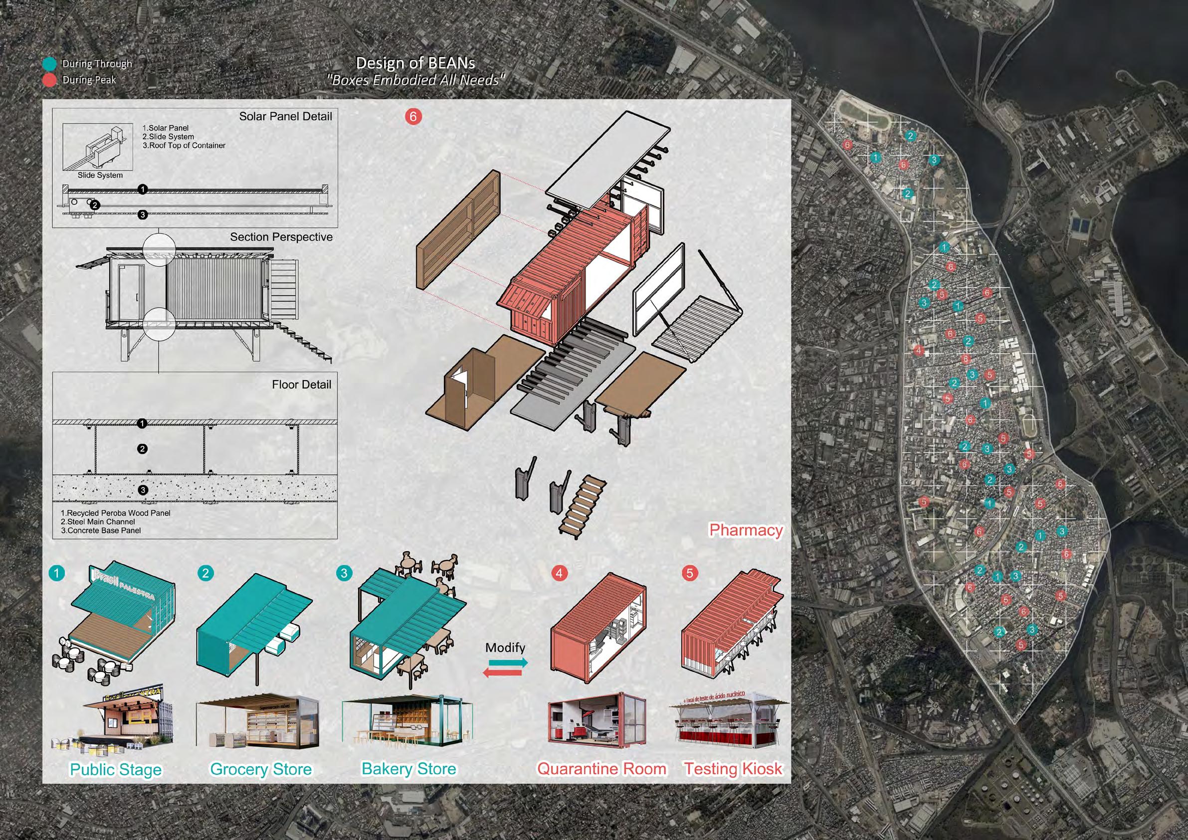
Design of POD "Plaza Of Diverse"


Through Peak
 An Alternative Response to COVID-19 for a Favela
25

An Alternative Response to COVID-19 for a Favela 26
"And the Lord said to Noah, Take all your family and go into the ark, for you only in this generation have I seen to be upright."
——Genesis 7:1
Response to Sea Level Rise & Urban Decline Oakland/California/USA
Academic & Personal
A Combination of an Individual Coursework Study and an Individual Volunteer Design Advisor (of Coursework Study): Karen Chapple, Abigail Cochran(Co-Instructor) Study was Finished in UC Berkeley at Spring, 2019 Design was Finished in Nanjing at Fall, 2019

Both were Refined at Fall, 2020
Full Coursework Study Link
https://www.ocf.berkeley.edu/~duanzhaoxuan/2019/03/22/west-oakland-what-is-going-on/
The urban history of West Oakland could date back to the 19th century. In 1849, Gold Rush happened and the population prospered. Central Pacific Railway company bought Oaklands waterfront property and created the Long Wharf in 1868. 25 years later, in 1893, the Key System of transportation was confirmed, which made West Oakland prosper and high in vitality.
The Great San Francisco Earthquake happened on April 18th, 1906. Many residents influx into West Oakland and the population doubled in this case. In 1912, 16th Street Train Station was built, acting as the terminal of railways from east. During 1940-50s, many people traveled from south of America to West Oakland, which is called “Great Migration” in this period.
According to scientists, sea level rise would threat all coastal cities, including the neighborhood of West Oakland. Sea level rise is a slow-moving threat, but it demands immediate action. Global warming creates hazards that cause significant harm to people, neighborhoods, infrastructure, and economy. In Bay Area, sea level rising is a major threat in a few decades.

The 89 Earthquake and the de-industrialization has done great harm to this area, and it affects West Oakland until now. The train station was shut down to build the highway near it, and it was finally abandonded in 1994. Today, we could observe a kind of mixed-up situation in West Oakland. New middle-class houses are built and several abandoned blocks remain, which means there are both urban decline and gentrification going on.
Reference
The 2030 Agenda for Sustainable Development SDG11: Make cities inclusive, safe, resilient and sustainable.
——United Nations, 2015
Ⅳ Resilience Planning & Design A Border: Stand to the Deluge
Trouble A: Environmental——Sea Level Rise
Trouble B: Social——Urban decline & Gentrification


28
Neighborhood


 Public
City Hall
Public
City Hall
A Border Response to Sea Level Rise & Urban Decline 29
Composition the Border Composition (In 1km Legth)
Arcade Neighborhood Hall × 1 × 40 × 4 × 1
Public Park


 Sea
Key Achievement 1: Public Life + Flood Proof
Key Achievemen 2: Public Life + Commercial Facility
Port-Neighborhood Section of the Border
Sea
Key Achievement 1: Public Life + Flood Proof
Key Achievemen 2: Public Life + Commercial Facility
Port-Neighborhood Section of the Border
A Border Response to
Level Rise & Urban Decline 30