NORWAY - Swimming With Orcas in the North Sea page 24
NORWAY - Face to Face With the Polar Bear page 28
ICELAND - From the Incandescent World page 34
ICELAND - In the Heart of the Glaciers page 38
GREENLAND - Where Icebergs Are Born page 44
ETHIOPIA - Bewitching and Inhospitable Dankalia page 48
RWANDA - Meeting Mountain Gorillas page 54
ZAMBIA - Victoria Falls: on the Edge of the Abyss page 60
NAMIBIA - The Roaring Dunes of the Skeleton Coast page 64
NAMIBIA - The Milky Way Above the Void page 70
BOTSWANA - On the Great River
Embraced by the Desert page 74
MADAGASCAR - At the Foot of the Karst Cathedral page 82
RUSSIA - On Lake Baikal, Where the Ice Is Bluer page 86
RUSSIA - Kamchatka: Land, Fire and Ice page 92
MONGOLIA - In the Footsteps of Genghis Khan page 98
CHINA - Danxia, the Rainbow Mountains page 104
NEPAL - The Lost Kingdom of Mustang page 108
INDIA - The Living Bridges of Meghalaya page 114
MALDIVES - The Sea Lights up page 118
THAILAND - Sailing Among Lotus Flowers page 122
VIET NAM - A Journey Through Time page 126
MALAYSIAN BORNEO - In the Kingdom of Biodiversity page 130
JAPAN - On the Paths of the Cherry Blossom page 136
JAPAN - The Poetry of the Fireflies page 140
JAPAN - Dip Into the Forest page 144
CANADA - Fantastic Lights in the North page 148
CANADA - Encounter With the Narwhal in Baffin Bay page 154
CANADA – Walking on the Bubbles of Abraham Lake page 158
USA - Strolling Among Cypresses in the Swamp page 162
USA - The Little Fire-Red Canyon in Arizona page 166
USA - Winter in the Grand Canyon page 170
USA - The Havasu Falls: a World in Miniature page 174
USA - The Canyon of the Trees in Bloom page 178
MEXICO - Diving Into History page 182
MEXICO - The Butterflies That Color the Woods of the Sierra page 188
COLOMBIA - The Liquid Rainbow page 192
BRAZIL - Setting Sail for Amazonia page 196
BRAZIL - The Natural Pools of Lençóis page 202
ECUADOR - Galápagos, the Enchanted Archipelago page 206
BOLIVIA - The Mirage of Salt page 214
CHILE - Atacama, the Most Arid World page 218
CHILE - The Mirage of the Marble Caves page 222
ARGENTINA - Adventures on the Glacier at the End of the World page 226
HAWAII - Big Island: Fire and Garlands of Flowers page 232
HAWAII - Walking in the Painted Forest page 238
POLYNESIA - Sailing to the Marquesas Islands page 242
TONGA - Swimming With Whales page 246
AUSTRALIA - Ribbon Reef, the Divers’ Paradise page 250
NEW ZEALAND - Waitomo Caves, the Underground Starlit Sky page 256
ANTARCTICA - Voyage to the End of the Ocean to Meet the Penguins page 260
page 268
FROM THE INCANDESCENT WORLD
THE WONDROUS BEAUTY OF A GEYSER JET, A SCALDING BREATH FROM THE FURTHEST DEPTHS, A CALL TO CONSIDER THE EARTH AS A LIVING ORGANISM. THIS MAKES US CURIOUS, ENCHANTS AND FRIGHTENS US.
Two drum beats followed by a repressed shout, like that of compressed underground water splitting the air with a dull vibration. Perhaps there is no link between them, but the cry chosen to support the Iceland soccer team
in the World Cups recalls that “devil’s jet” which is not the only trademark of the island, but expresses its essence: volcanoes and glaciers.
It is precisely the volcanoes, with their enormous power, which can block
European air traffic for weeks on end, which are responsible for the geyser, that minor effect, almost a slap from the center of the Earth.
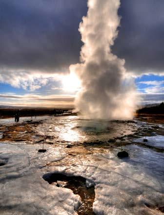
The term “geyser” is derived precisely from the name of the best known,
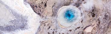
34 Strokkur, currently the most active geyser in Iceland, with a regular eruption often exceeding 130 feet in height. Every two or three days great explosions occur, caused by the accumulation of pressure.
35 Aerial view of Geysir, the most ancient geyser, in an area believed by geologists to have been active for 10,000 years. It can be recognized at a distance by the bursts of pure steam from the vents.
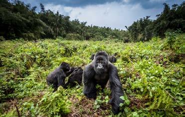
This nearness includes the fact that their pregnancy lasts nine months, and that the young play all the time, playing tricks on one another. This is the fascinating, or frightening, phenomenon: to come up against Darwin and his theories, to see in a primate a distant relative, a mirror, with whom we have an obvious link. Only a few hundred gorillas are left, so few that the population for some time has been included in the Iucn Red List with the note “critical danger of extinction,” for species which number under 2500 fertile animals. When we think of mountain gorillas,
we think of Dian Fossey, the American primatologist who moved to Rwanda to study them in 1966, and who stayed there until her violent death in 1985. She shone the spotlight on these primates, making them her life’s mission. When she arrived –at the invitation of paleontologist Louis Leakey, and supported financially by the National Geographic Society – for the local people she was “the woman who lives alone in the forest,” a strange character who spent her time studying and protecting the animals: her presence was barely tolerated. But as Jane Goodall has said, without
ADVICE FOR TRAVELERS
WHEN TO GO It is best to avoid the months of April and May, which is the rainy season.
HOW TO GET THERE The nearest airport to the park is Kigali; a 30-day entry visa can be requested at the airport of arrival. The bus transfer from the capital to the district of Ruhengeri (Musanze) near the Volcanoes National Park takes about two hours.
WHAT YOU NEED Sturdy hiking shoes, extendable walking sticks, spare clothes and drinks, light snacks, sun protection creams, hat and binoculars, light raincoat.
DIFFICULTIES Medium: you need to consider two to eight hours of hiking in the rain forest, in a hot, humid climate.
Dian Fossey mountain gorillas would no longer exist today. Her research work was a fundamental, scientific and cultural achievement, due both to her studies and the center named Karisoke, which was built in the rain forest between two volcanoes.
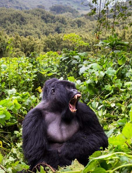
56 A silverback, the male leader of the group, shows his teeth. Gorillas are very close to humans’ evolutionary level; some scientists say that we share 98% of our DNA with them.
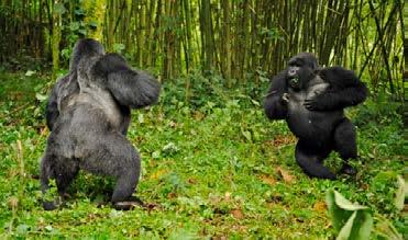
57 top Two male gorillas face up in a fight for domination. A defeated dominant male is destined to live a solitary life.
57 bottom A gorilla leads his family group in the forest of Virunga, at altitude 8,560 feet.
THE FIRST EXPLORERS
OF THE DELTA
If you thought that the first white man to see the Okavango was the inevitable, legendary Dr. David Livingstone, then you guessed right: he was coming from the Zambesi and was headed for the Kalahari in 1849. Four years later, the Swedish hunter C. J. Andersson was also awestruck by the magic of the delta. On returning, he related: “Wherever one looked, a sea of fresh water stretched, in many places hidden by clumps of rushes and reed-beds of every color and shade; numerous islands rich in luxuriant vegetation were scattered over the surface and conferred on the whole an indescribable beauty.”
However, only later, with the progress of geographical exploration, was the origin discovered of that “sea of fresh water and islands rich in luxuriant vegetation” which coexisted with one of the most desolate deserts on Earth.
By a quirk of nature, which in Africa, more than elsewhere, enjoys playing tricks, the source of the Okavango (or Cubango) lies on the Bié plateau. The river ignores the Atlantic coast of Angola, less than 180 miles away, and begins to descend slowly toward the center of the continent, touches Namibia, and then reaches Botswana where, in an imperceptible hollow only a few feet lower than the surrounding land, it fans out into different water courses, lagoons and islands. In accordance with its duty, as with all rivers in the plain, the Okavango opens its delta, as if it were offering itself to the sea. Yet it disappears slowly in the Kalahari sun, sinking into an ocean of sand and evaporating into the tropic sky.
SAILING AMONG LOTUS FLOWERS THAILAND
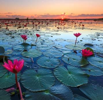
A PALETTE-FULL OF COLORS THAT PERHAPS ONLY NATURE CAN GIVE US, AN EXPANSE OF FLOATING VELVETY COROLLAS IN SHADES FROM BABY PINK TO DARK MAGENTA.
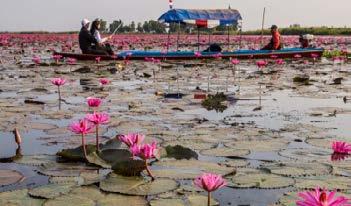
Northeast Thailand, province of Udon Thani. The boat begins its tour of the Red Lotus Sea, in the Kumphawapi Reserve, which combines a tropical flower garden with the peace of a lake reflecting the clear sky; a universe studded with flower species as far as the eye can see: small rafts moored on the banks, water lilies, wild plants, tiny fish among the algae.
122 Lotus flower corollas, in full flower; early in the morning is the best time to admire them. In the Oriental tradition, they are the symbol of purity: although their roots are in the mud, their petals are immaculate.
123 A typical boat sailing on the lake, which is just 3 feet deep.
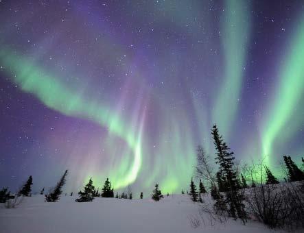
150 The phenomenon of the Aurora, which can create a thrilling atmosphere, was explained for the first time by the Norwegian physicist Kristian Birkeland at the end of the 19th century; but it was Galileo who gave it the name we know today.
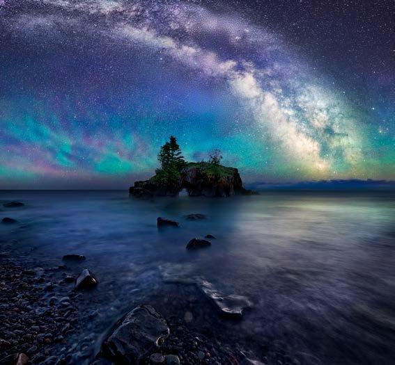
151 The Aurora over Lake Superior; it is tinged with blue when the solar particles come into contact with nitrogen atoms instead of oxygen atoms.
ADVICE FOR TRAVELERS
WHEN TO GO The entire year, but to observe the Aurora the best period is from October to April.
HOW TO GET THERE By plane as far as Whitehorse, then by rental car, preferably a 4x4.
WHAT YOU NEED Warm winter clothing as for an expedition, gloves and hat; spare batteries for photographic equipment.
DIFFICULTIES The trip is not for everyone. In particular, in winter it is essential to have experience driving on ice and snow, and familiarity with the intense cold and wild nature of northern regions.
WEB SITES www.travelcanada.ca, www.dempsterhighway.com, www.travelyukon.com, www.naturetoursyukon.com/winter-tours-yukon
The Yukon is one of the wildest regions of Canada, with fewer than 30,000 inhabitants in an area much greater than Arizona, where you find clear skies and little or no light pollution. These are the two main factors making the Yukon an ideal destination for those wishing to admire the Northern Lights.
It is not necessary to wait for the heart of the arctic winter, with its extreme temperatures. In Whitehorse, the high temperature in winter does not exceed 23 °F, with low temperatures around -13. Even in the mid-seasons like October or April, when the hours of light and darkness are more or less the same, it is possible to enjoy the spectacle provided by the sky while also enjoying what the
area can offer in the daytime. Obviously to see the Lights you need a clear sky, to stay awake at night, to have suitable equipment for the intense cold, and to move away from the city. The dance of the Aurora Borealis in the winter sky, which is sometimes sensual and sometimes convoluted, enchants everyone. Fleeting apparitions, sometimes persistent, often amazing: in any case, they create deep emotions and memories that do not fade in time. In reality, the phenomenon occurs in both the polar regions over the entire year.
A forest begins just outside Whitehorse, with chocolatecolored hills, and turquoise or emerald lakes as far as Dawson
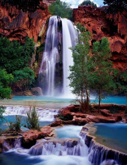
THE HAVASU FALLS: A WORLD IN MINIATURE
A NATURAL AMPHITHEATER DUG INTO CLIFFS OF RED ROCK TYPICAL OF THE GREAT CANYONS OF THE AMERICAN WEST, ITS BEAUTY ENHANCED BY WATERFALLS AND NATURAL POOLS OF TURQUOISE WATER.
The Havasupai, a tribe of the native people, have always lived in what for many of us is the perfect representation of earthly paradise: the valley of the Havasu Falls. Emerald-colored water, blood-colored rocks, the green of bushes and the white of travertine concretions: probably not even Adam and Eve had a similar Eden to live in. It is small but extremely varied. Owing to the water’s high mineral content, which produces
frequent subsidence and modifications in the riverbed, waterfalls continue to change continuously because, even in limited time periods, the course of the river is slightly modified.
Credit for this miracle of nature goes to the Havasu Creek, a tributary of the Colorado River, with which it contributes to creating the spectacular natural scenery of the Grand Canyon. But the Havasu Falls are outside the jurisdiction of
the Grand Canyon National Park, in the territory controlled by the eponymous Indian tribe. For this reason, they are not assaulted by the hordes of tourists which every day crowd these areas.
174 The intense colors of the landscape around Havasu Falls; there are four other waterfalls in the reserve. They can easily be reached on foot.
175 The terraced pools of travertine fed by the waterfall. The limestone is very resistant to atmospheric agents and erosion.
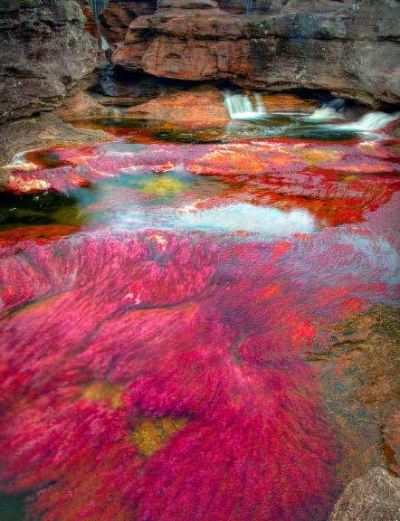
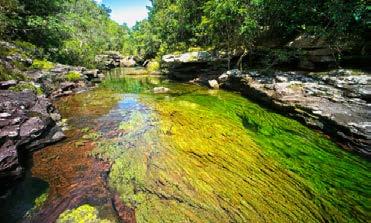
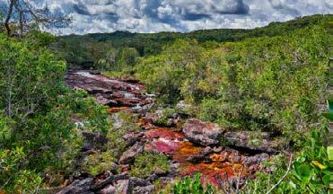
In November, the algae dry and enter the reproductive phase, losing their color. The magic temporarily ceases and the Caño Cristales is once again a “normal” river in the green province of Meta.
While for a long time the park was inaccessible to the public because it was on the route of the Colombian revolutionary forces, today it can be visited, thanks to a peace agreement signed with the government. However, the most serious threat at the moment is climate change.
You cannot enjoy so much beauty without an authorized guide guaranteeing
the safety of the route; in fact, the protected area in some places is still very wild and without signs. Apart from being the habitat of pumas, jaguars, and iguanas, a more welcome presence, the hoatzin (Opisthocomus hoazin) might peep out: It has a rock singer’s fringe and multicolor plumage. But there are no fish: the river has no sediment and provides no food for water creatures.
As you walk, you almost want to stop at every step because the river bed, the water, the sky, the vegetation come together in ways that are always unpredictable and fascinating.
ADVICE FOR TRAVELERS
WHEN TO GO The park is open from mid-June to the end of November, but the best period to see the phenomenon is in the last two months, starting from September.
HOW TO GET THERE
You leave from La Macarena, which can be reached by light aircraft from Bogotá; from the port, you can follow the Rio Guayabero in a launch, or else reach the entrance to the park in a 4x4. The local agencies organize guided excursions toward the river, on foot or on horseback. The routes can change depending on the climatic conditions and the number of visitors.
WHAT YOU NEED Light clothing that provides protection from the sun and dries quickly; comfortable, ankle-high waterproof shoes. Be advised: inside the park the use of sun protection creams, mosquito repellents, and other chemical products is prohibited.
DIFFICULTIES
Accessible to everyone, but bear in mind that for most of the excursion you are crossing the river, with water up to your ankles or your knees.
194 Little streams spring from the rocks and feed the multicolored river.
195 top In different sections, the colors of the Caño Cristales have shifting green, red, yellow, blue, and white shades.
195 bottom The hike to the river is accompanied by specialist guides; it is quite demanding, but the effort is amply repaid.
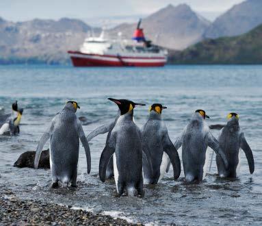
ANTARCTICA
VOYAGE TO THE END OF THE OCEAN TO MEET THE PENGUINS
A FIERCE CLIMATE AND UNEXPECTED STORMS GREET THE TRAVELER WHO DARES TO CROSS THE LIMITS OF THE WORLD: THE FALKLANDS, SOUTH GEORGIA AND SOUTHERN SHETLAND HOST COLONIES OF BIRDS WHICH ARE ATTRACTED BY HUMANS.
Under a leaden sky, the “southernmost city in the world” has an the uncompromising aspect of wild lands. It is crowned by mountains which disappear into the titanium reflections of the Beagle Strait.
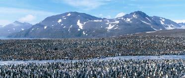
260 A huge column of royal penguins in St Andrews Bay, in South Georgia. Penguins are aquatic birds but incapable of flying; the fins they use for swimming were originally wings.
260-261 In search of food, shortly before diving into Antarctic waters. Emperor penguins feed on krill, shrimp and fish, even swimming 50 miles to catch them.