
IRRIGATION PAPERS
UNITED STATES GEOLOGICAL SURVEY
ISTo. 33
DEPARTMENT OF THE JNTEB8IOR
WASHINGTON GOVERNMENT PRINTING OFFICE 1899
CHARLES D. WALCOTT, DIRECTOR
WATER RESOURCES OF PUERTO RICO
 BY HERBERT M. WILSON
STATES GEOLOGICAL SIIEVEY
UNITED
WASHINGTON GOVERNMENT PRINTITm OFFICE 1899
CONTENTS.

Letterof transmittaL.----...-..---..-..-_--_.._..--.--_----_--.__...._. 9
Topographicrelief..., -.-... ................,.......^..................... ±1
Coastal topography...-- .._._ .._.__._._. .__.-.---. ------------------ 14 Physiography and scenery ..-..._..___._.._._-_...-.-_-......-.--.----. 15 Climatology..-----.---. ..^......................................... ------ 21 Precipitation.....-._-..__.._.._ -.-_--,..-..--..----._--------------- 22 Temperature .......--.-.-.........._...-...-.........._.......... ..- 24 Hydrography...-.-........-.._.--.--............-...---...--.....-....-.- 24 Irrigation 28 Agricultural lands and soil....---......--.......--..-......,..:..-......- 32 Oldfields andfertilizers.-..._....--. .--.-...-.--...---..--------... 33 Agricultural products --.-_._-.__.-..._._....___.____,_---...--..-. _. 34 Forestry -...-.-.....--.......----...-........-...-....--....-..--..-..--- 41 Water power and supply... -_.-_........ ......-..--.---- ..---. --.--.-..-. 43 Transportation facilities...................... ............................ 44 Index....-...--.....-..,--. ..---...--..-......----.-.-..-,-..--.--..---- 47 5
ILLUSTRATIONS.
Page.
PLATE I. Drainage and hypsometric map of Puerto Rico ___._.___-._,.._-. 11
II. A, Carolina Plain with El Yunquein distance; B, Playa at mouth of Rio Loiza; C, Rio Canovanas; D, Foothills of Sierra de Luquilla, showing field and eocoanut trees_.._._-...---.--..-.-. 16
III. A, West from Cayey divide; B, Rio Jacaguas near Juana Diaz . _ 16
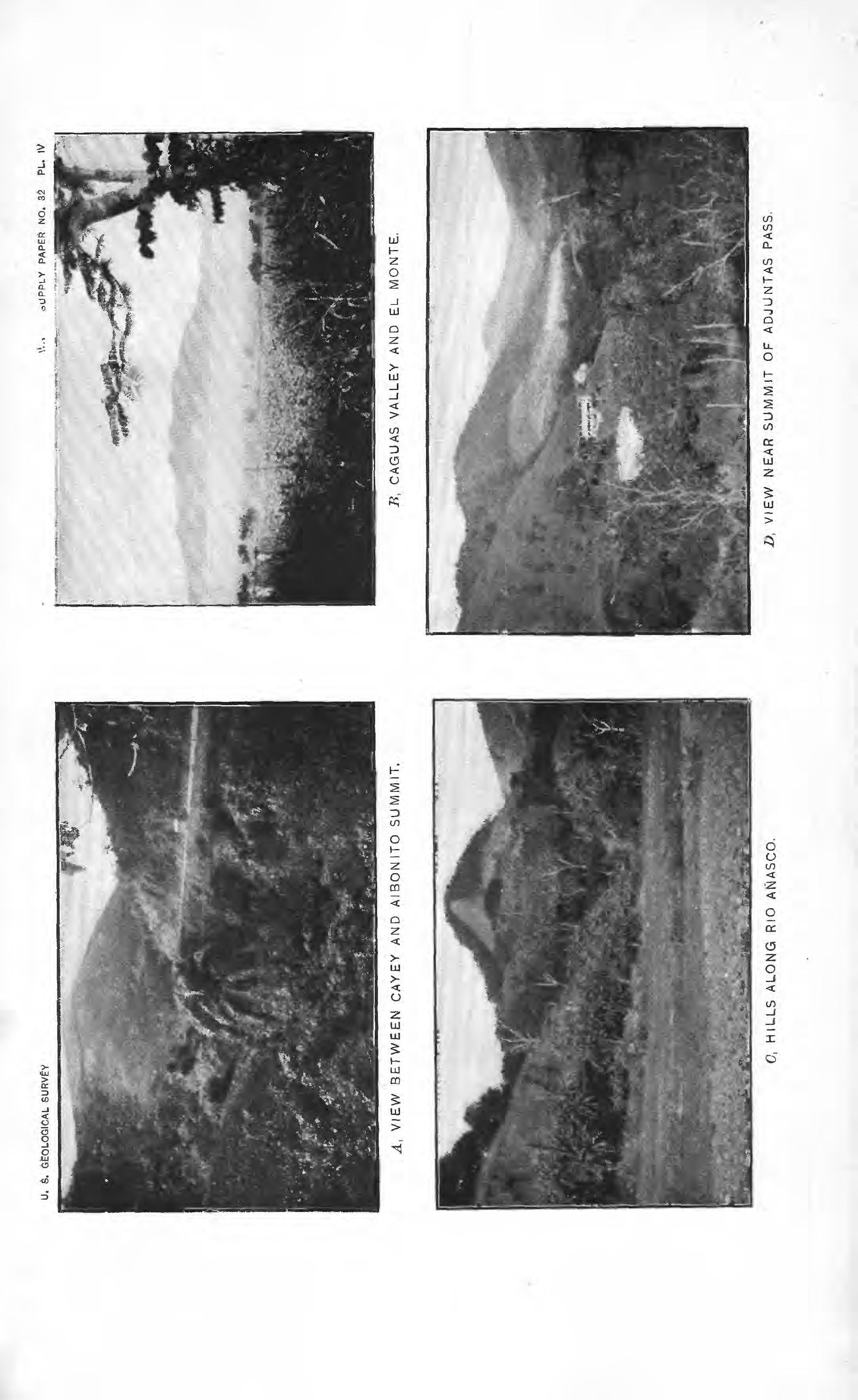
IV. A, Between Cayey and Aibonito summit; B, Caguas Valley and El Monte; 0, Hills along Rio Anasco; D, Near summit of Adjuntas Pass.-,.-------------.-._-.-.._-.-..-.-..---.----.-.--- 18
V. A, Scenery south of Aibonito summit; B, Bent mango trees, « San Juan. ...... ^............................................. 18
VI. Barren Mils near Juana Diaz _.__.__...,._.....-.------..---.,-.- 20
VII. A, Westward toward Lares from La Torre summit; U»Toward Lares from the east; cocoanuts and bananas in foreground. ... £2
VIII. A, Parting Valley about and hills back of -Yauco; B, Arid flora near Lares; C, Fording Rio Loiza, near Carolina; D, Rio Portugues, at Ponce _.._._.._____.___-...---_.-.-_.-_-.-. -.-'--..- 26
IX. A, Rio Descalabrado; B, Rio ASasco; C', Regulator gate and ditch; J), Wing dam...... ._..._._-___ -....... 28
X. .4, River bed and masonry conduit; B, Irrigation ditch in earth; C, Sugar land near Ponce; D, Guinea grass, Caguas Valley.... 32
XI. A, Mountain summits under cultivation; B, Ox cart; C, Saddle and pack horse; D, Hogs led by rope..................._---_.. 34
XIL A, Sugar cane; B, Train of cars loaded with sugar cane drawn by oxen; C, Coffee shade; D, Shelling coffee............ ...... 36
XIII. Map showing distribution of crops.-......--......-..--.---.-.,. 38
XIV. A, Cotton plant; B, Market scene, Ponce; C, Logs of ausubo en route to market; D, Repairing military road ..........-..._... 40

XV. A, Mamey (bread fruit) tree in field of yautia, Rio Canovanas; B, Clump of bamboo; C, Near summit of Sierra de Luquilla; D, Ceiba tree in field of guinea grass ...-.....-.-..-.....--.... 42
XVI. A, Muddy cart road near Adjuntas; B, Muddy cart road near Aibonito; C, Rockycart road near Lares; D, Rnttecl coral rock in cart road near San Sebastian __________-.-.._-_..-,-..---... 44
Bridge
...-..-.........---.
1. Section north and south through El
12 2. Section north and south through San Juan .......-.-..---.-.---..- 13 o. Section north and south throughPonce._."-.....-.._-.-....---.---- 13 4. Cordillera Central, parting valley, coast limestone hills, and playa at Ponce ...................-....._............... ..-.-....---- 15 5. Piloncilios, or conical coral hills; Lares.............----.-.-.-...-.. 20 6. Inverted siphon carrying ditch undermilitary road ._........-.-... 30 7. Masonry conduit and retaining wall. ......-..-...^............,..- 31 8. Cultivated hilltops in Cayey tobacco district,.-.-...-.. ........... 37 9. Drying coffee on rolling platforms; Pietris
_. S8 10. Rockwork near
of
road..... ........... 45 7
XVII. A,
over Rio Cana near Caguas; B, Rocky cart road near Lares..,--..-...............-...-..-...-.
46 Fia.
Yunque......----.-..-..,...-.
plantation, Adjuntas
Aibonito, summit
military
LETTER OF TRANSMITTAL.

DEPARTMENT OF THE INTERIOR, UNITED STATES GEOLOGICAL, SURVEY, DIVISION OF HYDROGRAPHY, Washington, My 31, 1899.
SIR: I have the honor to transmit herewith a manuscript relating to the water resources of Puerto Rico and to request that it be published as one of the series of Water-Supply and Irrigation Papers, The report is based on notes, sketches, and photographs gathered by Mr. Herbert M. Wilson during a brief journey made through the island of Puerto Rico in January^ 1899. The object of this trip was primarily to study the topographic characteristics and the water resources of the island, but incidentally numerous memoranda relative to the soil, agricultural products, and forests were obtained.
Mr. Wilson landed at the capital city of San Juan, whence a short trip was made by rail via Rio Piedras to .Carolina, whence saddle animals were taken still farther eastward to Canovanas and southward up the river of that name to its head waters, in the Sierra de Luquilla. After returning to San Juan he proceeded by ambulance over the military road, which crosses the island diagonally toward the southwest, via Caguas, Cayey, Aibonito, Coamo, and Juana Diaz, to Ponce, traveling by slow stages andtmaking the distance of 80 miles in four days.
At Ponce Mr. Wilson and his party were furnished with pack and saddle animals and civilian packers and set out the next day via Adjuntas and Lares, San Sebastian, and Anasco to Mayaguez, on the west coast. Thence the return journey to Ponce was made on horseback via Hormigueros and San German to Yauco, where rail was taken for Ponce.
Thus the trip included the countryfrom the mountain tops nearthe eastern end of the island to near the southeast coast above Guayama and to the south coast at Ponce, a return to near the northwest coast at Lares, and a circuit of the southwestern coast from. Mayaguez to Ponce. The party crossed or visited the head waters of all the more important streams, saw nearly the entire country from the vantage points of the high summits, and visited nearly all of the larger cities except those at the eastern extremity of the island.
This route led into the highest mountains at the eastern end of the island, within view of El Yunque, the highest peak; also into the Sierra de Cayey and the Cordillera Central, occupying the main length of the island, and, finally, into the low coral sugar loaves near Lares, and the limestone and volcanic foothills of the Tetas de Cerro Gordo and Las Sillas de Calderon, in the southwestern corner of the island. The data thus obtained concerning the water resources of this newly acquired portion of the United States are believed to be of sufficient importance to warrant early publication in this series of papers. Very respectfully, ^ F. H. NEWELL, Hydrographer in Cliarge. Hon. CHARLES D. WALCOTT, Director United States Geological Survey.

10 LETTER
OF TEANSMITTAL.
WATER RESOURCES OF PUERTO RICO.
 By HERBERT M. WILSON.
TOPOGRAPHIC RELIEF.
Puerto Rico, as shown on the map (PI. I), is situated between latitudes 17° 54' and 18° 30' north and longitudes 65° 13' and 67° 15' west, thus lying well within the Torrid Zone. It is the easternmost as well as the southernmost of the Greater Antilles, though still farther to the east are the lesser of the West Indian islands belonging to the Windward Group. The shores are washed on the north by the waters of the Atlantic Ocean, on the south and east by those of the Caribbean Sea, and on the,west by Mona Passage, which separates the island from Haiti. According to the best information obtainable from measurement of existing maps, the area of Puerto Rico, exclusive of the dependent islands chief among which are Mona on the west and Viequas and Culebra on the east is 3,670 square miles. Its area is thus one-fourth, or 1,200 miles, less than that of the State of Connecticut, and is nearly three times as great as the area of Long Island. Its average width is 35 miles, or twice the width of Long Island, while its average length is 105 miles, or about the same asthat of Long Island. Fourth of the Greater Antilles in size, it is roughly rectangularin form, its major axis lying almost exactly east and west.
The essentialtopographiccharacteristic of Puerto Rico is its exceedingly mountainous and highly eroded aspect, in spite of which none of its summits attain great altitude. The island is also notable for the abruptness with which the foothills of the mountain slopes plunge into the ocean, leaving practically no marginal coast plain, and for the variety in topographic form, resulting from great differences of erosive action at either extremity of the island and from changes in geologic structure. Extending irregularly through the entire length of the island from the extreme northeastern point, at Cabeza de San Juan, to the extreme western points, near Rincon and Cabo Rojo, is a series of connected mountain ranges forming the main divide between the drainage of the north and south coasts. At the eastern end of 11

U.S.GEOLOGICAL SURVEY WATER SUPPLY PAPER N9 32 PL.l. ft»B£$$£' -^kencontouisrqni^ent25Ofeetelevations. Railroads Macadam* Second class roads DRAINAGE AND HYPSOMETRIC MAP OF PUERTO RICO A.Ho«n Cn. LLtb.B.llii, BY
HERBERT M.WILSON.
OF PUERTO RICO. [NO. 32. this island the most commanding range, the Sierra de Luquilla, terminates near its eastern extremity in the highest peak on the island, El Yunque, the elevation of which is given by Spanish authorities as 1,520 meters, or approximately 4,940 feet. This appears to be an error, since, according to an aneroid reading by Mr. A. Hansard, its height is about 3,250 feet, while the maps of the United States War Department and charts of the United States Hydrographic Office and of the United States Coast and Geodetic SurveygiTre its altitude as between 3,610 and 3,790 feet. Which of these elevations is most nearly correctit is atpresent difficult toascertain. Anorth-south cross
SCALE
10 20 MILES
FIG. 1. Section north and south through El Yunque. section through El Yunque (fig. 1) givejs some idea of the abruptness of the fall to the north, and is in striking contrast to the cross sections taken elsewhere on the island (figs. 2 and 3), which show the steepest slopes to the south.

A southern spur of the Luquillas connects this mountain rangewith, the northeastern spur of the Sierra de Cayey in a low divide but 5 miles from the coast, near Humacao; thence the Sierra de Cayey extends westward to Aibonito Pass with comparatively uniform elevations between 2,200 feet in the lowest divides and 3,200 feet on the highest summits, none of which are especially pronounced. This portion of the main range of mountains skirts the eastern and southern coasts very closely, so that the greater portion of the drainage of the eastern third of the island is to the north, the southern and eastern coasts receiving the drainage from a narrow belt of country but 5 to 10 miles in width. The length of the drainage to the north, measured in an air line, is from 25 to 30 miles.
AtAibonitothe military road from San Juan toPonce passes through the lowest divide in the central range of mountains, the elevation of this being approximately 1,840 feet above sea level. As a result of the closeness with which these mountains skirt the eastern and southern coasts, they suddenly fall off in a distance of but 2 to 3 miles hori-
12 WATER
RESOURCES
zontally from altitudes of 2,500 to 3,000 feet to the back coast border, at elevations of 200 to 300 feet. The abruptness of the escarpmentto the south and east can thus be realized, and is illustrated by a northsouth cross section (fig. 2) constructed through Guayama and San Juan. This cross section also shows that the fall to the north, while not so great, is still quite abrupt, reaching the elevated basin about
SCALE to
PIG. a Section north and south through San Juan. Cayeyat an altitude of 1,200 feet, and is thence more gradualthrough the rolling country drained by the Rios Loiza and Guayanabo, in the neighborhood of Caguas, Aguas Buenas, and Comeiro.
To the west of Aibonito the main dividing range rises sharply in a broader and more stronglymaintainedsierra, whichhas here the name Cordillera Central. Thepassesthroughthe Cordillera attain altitudes of 2,500 to 2,800 feet, but upon it there are no marked peaks, the highest summit scarcely reaching 3,300 feet in altitude. The Cordillera Central is interrupted to the north of Ponce in a pass 2,320 feet in altitude, leading to Adjuntas, at the head waters of the Rios Portu-
SCALE
FIG. 3. Section north and south through Ponca gues and Arecibo. A cross section of Puerto Rico from Ponce to Arecibo (fig. 3) does not differ materially from that between Guayama and San Juan, the chief points of difference being that the slopes to the south do not fall away quite so abruptly as farther east, while to the north the slope is decidedly more gradual than in the neighborhood of Caguas.

WILSON.} - TOPOGRAPHIC RELIEF. 13
OP PUERTO RICO.
West of Adjuntas the sierra rises abruptly to El Guilarte, altitude 3,608 feet, which is the second mountain on the island in height. Here the character of the main dividing mountain range is abruptly changed. A number of rugged spurs branch northwestward toward Lares and Las Marias, westward toward Horrnigueros, and southwestward toward San German. These spurs have not the continuity of the main mountain range from which they spring, but are broken up into a number of irregular ridges and peaks of extremely rugged aspect.
The series of controlling mountain ranges as sketched above are of the same geologic time and origin; all are of mixed volcanic and sedimentary origin, consisting chiefly of hornblende-andesites, gneiss, and tuff, embedded in which, but found at altitudes generally below 2,000 feet, is a compact blue limestone of Cretaceous time.

Abutting against the-foothills of these commanding sierras, and forming secondary topographic features of striking importance, are a number of varied forms found at different portions of the island and owing their shape and mode of weathering to their geologic origin. On the north coast, between Arecibo, San Juan, and Fajardo, the main summits fall away rather abruptly to elevations of between 1,000 and 1,500 feet; they then continue as radial spurs, sloping gently to the northward and interrupted by numerous undulations, culminating often in peaks of considerable altitude and prominence.
These are separated by the principal rivers draining the interior, which flow generally to the north, but are deeply indented in the surface of the country. Thus within 5 or 6 miles to the north of the main summits the river bottoms are at altitudes of about 1,000 feet, while the summits of the ridges above are at elevations of 2,000 to 2,500 feet. Again, within 5 miles of the coast, the river beds are at elevations of 50 to 100 feet above sea level, while the summits of the dividing ridges reach altitudes of 1,000 to 1,500 feet. These dividing ridges are often maintained to the ocean shore, are high, narrow, and A-shaped, and are separated one from the other by deep V-shaped valleys eroded by numerous streams flowing in every direction throughout the interior of the island.
COASTAL TOPOGRAPHY.
The topography of the coast border consists of narrow marginal plains extending here and there up the river valleys for from 3 to 5 miles. These flat coast lands are called playas, and their continuity is broken on the northeast, southeast, and northwest by spurs of.the main mountain mass which plunge directly into the ocean. These encircling plains and playas are, moreover, irregularly broken by low coast hills. On the souththese are all of limestone and are 200 to 400 feet in height; on the north they are a series of old coral reefs eroded into detached hills of 50 to 150 feet in height. Thus the coast topog-
14 WATER RESOURCES
[NO.32.
raphy may be divided into three types, distinct from the central mountain mass, consisting of (1) the playas or plains; (2) coast hills and parting valleys which separate the latter from the foothill spurs of the central mountains; and (3) a highly eroded coral plateau, an intermediate topographic type beween the sierras and the coasttopography, found in the northwest portion of the island between Arecibo, Lares, and Isabela. The ascent to this latter from the west in the neighborhood of Aguadilla is abrupt and the surface of the plateau is gently rolling. This is cut by the moreimportant streams, whichhave eroded abrupt canyon walls 150 to 200 feet in height. To the south this is topped by a higher series of sugar-loaf shaped buttes of coral, the summit elevation of which is about 1,200 feet.
Still another topographic type, distinctive only in that it is an exaggeration of the limestone hills and parting valleys found elsewhere, is that between Mayaguez, Cabo Rojo, and Ponce, in the southwestern' corner of the island. Here the sea isbordered by a lowledge of coral, capped by a heavy stratum of hard limestone. This is tilted upward
FIG. 4. Cordillera Central, parting valley, coastlimestone Mils, and playa at Ponce. so as to rise from the southwest toward the center of the island, and is separated from the main sierra by two long andfertile parting valleys. Elsewhere on the island, and especially well developed from Ponce eastward to beyond Guayama, the low coast hills of limestone have their east-west continuity broken by the playas at the stream mouths. They are also separated front the main sierra by short, narrowparting valleys, eroded bybranches of the streams which drain the main summits (fig. 4). Some of these hills terminate abruptly at the sea in bluffs 100 feet in height, while the parting valleys which border them on the north have elevations of 100 to 200 feet, their summits reaching altitudes of 500 to 1,000 feet.

PHYSIOGRAPHY AND SCENERY.
Inorderthat the topographicformsofthe island may be more clearly comprehended,'the following detailed description is given of some of the more striking surface characteristics along the route traveled.
WILSON.] COASTAL TOPOGRAPHY. 15
OP PUERTO RICO. [wo.32.

The country traversed by railway eastward from San Juan as far as Carolina, and thence by military road to Rio Grande is typical of the larger playas reaching from the sea' margin to the back coast border. This is a comparatively flat alluvial plain (see PI. II, A) about the mouth of the Rio Loiza and its branches. It hasbeen built up largely through the aid of mangrove growth, which has encroached upon the sea and retained the alluvium broughtdown bythe streams. Between Rio Piedras and Carolina this alluvial plain is 5 miles in width from the seashore. Its greatest width, near the mouth of the river opposite the town of Loiza, is 9 miles. In the total air-line distance of 20 miles from near San Juan to beyond Rio Grande this plain is cut by three large lagoons, and the area of this magnificent stretch of agricultural land is about 100 square miles. The whole is well cultivated in a rich forage grass, called "Guinea grass," and in sugar cane.
* To the south of the edge of this playa the hills rise rapidly in"broken spurs, which radiate from the summit of the Sierra de Luquilla. This playa land is, moreover, not an unbroken plain. It is comparatively level, however, rising from a few feet to about 60 to 75 feet above sea level. The apparently dead level of thisplaya isinterrupted by occa sional low, bluff-topped hills of coral rock (see PI. II, J5), which have not been entirely eroded away.
A journey southward from Canovanas, up the river of that nameto the summit of the Sierra de Luquilla, brings one immediately into the roughest of the highly eroded and rugged mountains which are so characteristic of the island. Cart roads extend up this river, as well as up all the other more level^ streams, until the diminished width of the gorge through which it flows and the roughness of the country cause them to be superseded by trails. The river flows over a rough, rocky bed and between steep slopes (see PI. II, (7), which are thickly covered with natural and cultivated vegetation. The cart road and the trail ford the river fifteen or twenty times in a distance of about 6 miles, due to the sharp curves of the stream between the confining mountain slopes. At the end of that distance, at an elevation of about 250 feet, the gorge has become so narrowed that the trailleaves it and climbs abruptly, in 2 or 3 miles, to an altitude of 1,350 feet. In all directionsbranch trails lead up the steepest slopes to the habitations of the peasants, who are everywhere engaged in the cultivation of the various crops which thrive best in each particular locality. (See PI. II, D.)
The military road from San Juan to Caguas passes through a hilly depression, between thewesternterminus of the SierradeLuquilla and the northern spurs of the Cordillera Central. Thedivide between the drainage basins of the Rios Loiza and Bayamon is crossed at an altitude of but 375 feet. At Caguas a broad mountain valley on the head waters of the various branches of the Rio Lo.iza is entered at an altitude of 230 feet. The slopes in every direction are not abrupt;
16 WATER RESOURCES

U. S, GEOLOGICAL SURVEY
PAPER NO. 32 PL. Il A, CAROLINA PLAIN, WITH EL YUNQUE IN DISTANCE i>, PLAYA AT MOUTH OF RIO LOIZA.
WATER-SUPPLY
O, RIO CANOVANAS.
D, FOOTHILLS OF SIERRA DE LUQUILLA, SHOWING FIELD AND COCOANUT TREES,

U. S. GEOLOGICAL SURVEY WATER-SUPPLY PAPER NO. 32 PL. Ill
A, VIEW WEST FROM CAYEY DIVIDE.
B, RIO JACAGUAS NEAR JUANA DIAZ.
their altitudes are not great, and all are well cultivated. The road southward to Cayey remains in the general depression at the head waters of the Bios Loiza and Plata, and is surrourided on the east and south by much higher and more rugged mountains, which slope upward to the summits of th^ main divide. To the northeast are numerous highly eroded ridges and peaks, the northward radial spursofthe SierradeCayeyandof theCordilleraCentral. Las Cruces, the highest pass between the head waters of the Rios Loiza and Plata, is crossed at an altitude of 1,310 feet. (SeePI. Ill, A.) Immediatelythereafterthe road descends abruptly to the " vegas," orplain, between altitudes 1,080 and 810 feet, extending for about 6 miles to and beyond Cayey. The valley about that city is .gently rolling, the country sloping away rather abruptly to the Rio Plata on the north, whence it rises rapidly to the higher summits of thenorthward radial spurs. To the south the summits of the main divides are nearly 2,000 feet directly over thevalleys. Abrupt as are the slopes all areheavily covered with soil and vegetation.

Beyond Cayey the road climbs rapidly to the main divide between the drainage areas tributary to the north and south coast. (See PI. IV, A. ) This divide is crossed within 2 mile's of Aibonito at an altitude of 1,860 feet. Thence there is a gradual descent of but 100 feet to the. rolling tableland about Aibonito, beyond which at an equal distance is a second summit with an altitude of 1,810 feet. The summits of the main sierra, as seen from the Aibonito uplands, have everywhere the same highly eroded forms, irregularly shaped mountain ridges, long spurs, and isolated peaks, jutting out in every direction to altitudes of 500 to 1,000feet above the rollingupland on which their bases rest at elevations of 1,700 to 2,000 feet.
Beyond the second summit at Aibonito Pass the road descends with great abruptness in but 6 miles, as measured along its meanderings, and only 2 miles in an air line, for 1,400 feet, to an altitude 420 feet. Here is Some of the most magnificent mountain scenery. (See PL V, A.) The character of the topography, as well as of the flora, changes entirely as the semihumid side of the island is approached. The brilliant green here disappears from the vegetation, the damp moss and fern-covered slopes are gone, and all is covered with short, dry grass (see PI. VI), not unlike the bunch and buffalo grass of the West, with acacias and with other arid flora. At the same time the topographic forms do not exhibit the same high degree of erosion. Though exceedingly abrupt, the mountain slopes are more uniform andless intensely cutintoseparate spurs and peaks. The depth of the soil is much less than on the northern slopes, and rocky ledges and bluffs occasionally protrude.
The whole of the region from San Juan to Aibonito is picturesque in the extreme, and has an exceedingly pastoral and peaceful aspect. Caguas Valley is ideally beautiful. It is almost circular, about 3 by IRR d2 «
WILSON.] PHYSIOGRAPHY AND SCENERY. 17
OF PUERTO RICO. [NO.32.
4 miles in dimension, and through it winds in great serpentine curves the Rios Caguitas and Turabo. The former makes a long coil about El Monte, a lone hill 300 feet in height which occupies the center of the valley. (See PI. IV, B.) Among the higher summits about Aibonito the country still has the same picturesque aspect, the same pleasantly pastoral appearance, accentuated only by the immensity of the slopes. From the highersummits the Atlantic Ocean is in plain view to the north and the Caribbean Sea to the south. Every detail of topography may be seen for miles in all directions, as though one were viewing a model map.
Beyond Oayey and thence to Coamo the great mountainmasses rise to such sheer heights or descend so abruptly to the bottoms of great gorges as to be imposing in the extreme. Between Coamo,JuanaDiaz, and Ponce the aspect of the country is entirely dissimilar to that seen elsewhere on the route. The military road skirts the southern slopes of the Cordillera Central and remains at a fairlyconstant distance of 5 miles back of the coast. It crosses six of the more important rivers which drain the southern slopes (see PI. Ill, B), yet at no place does it attain an altitude greater than 250 feet above sea level, nor at the stream crossings is it less than 100 feet above sea level.
To the north the masses of the main sierra rise abruptly in great jagged spurs, with fairly uniform slopes. In all other directions the country is a rolling plain, broken by numerous ridges and detached hills. (See PL VI.) These are separated by small and level parting valleys, relatively broad and all under cultivation, chiefly in sugar cane. (See PL X, (7.) The entire south coast is 1 to 7 miles in width, averaging about 5 miles, and from east of Guayama to a little west of Ponce is of this same general character. The sea is bordered by coral reefs, sometimes, especially near the river mouths, by small playas, and back of these, often quite close to the coast, rising northward there is a tilted limestone table-land.. This is eroded into detached hills and ridges both by the north-south primary drainage and by the east-west lateral drainage which forms the parting valleys. There is thus seen to be a large area of excellent agricultural land along the coast, but this is generally so arid as to require irrigation for the cultivation of such thirsty crops as sugar cane. Small fruits and vegetables are grown without irrigation and all the hills are covered with forage grass. The mountain slopes on this side, however, are not nearly so extensively cultivated as on the north side. In addition to the disadvantage of unfavorable soil and insufficient precipitation, comparatively little foothold is given to vegetation on their steep sides.
On the road from Ponce to Adjuntas, which ascends first the general course of the Rio Magueyes and near the summit crosses to the head waters of the Rio Portugues, one has an almost south-north cross section of the sierras, as compared with the diagonal section viewed

18 WATER RESOURCES
U. S. GEOLOGICAL SURVEY UPPLY PAPEft NO. 32 PL. IV A, VIEW BETWEEN CAY EY AND AIBONITO SUMMIT. K, CAGUAS VALLEY AND EL MONTE. C, HILLS ALONG RIO ANASCO. D, VIEW NEAR SUMMIT OF ADJUNTAS PASS,

U. S. GEOLOGICAL SURVEY WATER-SUPPLY PAPER NO. 32 PL- V
A, SCENERY SOUTH OF AIBONITO SUMMIT.
fi, BENT MANGO TREES. SAN JUAN.
PHYSIOGRAPHY
AND SCENERY.
in traveling southwestward from Aibonitoto Ponce. The topographic characteristics are identical with those seen, however, on the latter route. Four miles to the north of Ponce the elevation is but 50 feet. The way climbs for the next 3 or 4 miles through sloping.foothills to an altitude of 400 feet. Thereafter, in 2 mites horizontally, the ascent to the main ridge dividing the two rivers is to an altitude of 1,720 feet. With equal abruptness the main summit (see PL IV, D) is reached about 15 miles from Ponce, at an altitude of 2,320 feet.
Adjuntas is on the northern slope and on the head waters of the Rio Arecibo. About it the topographic characteristics are in all respects similar to those observed at Aibonito. But a few miles to the southwestrises El Guilarte; to the north are seen long radial spurs of the main sierra, which are separated at Utuado by the valley of the Arecibo; northwestward another long spur extends to and beyond Lares and San Sebastian to the western sea at Aguadilla. This separates tli© head watersof the various rivers which emptyinto the northern ocean between Arecibo and Aguadilla and the drainage of the Rios Culebrina and Prieto, which flow into the western sea at Aguadilla and Anasco, respectively. The spur which extends to the southwest, and on which are El Guilarte, Las Sillas de Calderon, Tetas de Cerro Gofdo, and other prominent peaks, separates the waters of the Rios Prieto and Blanco from those of the Rio Guaaajibo.
It is thus seen that the neighborhood of Adjunfeas is, as^the name implies, the dividing point of the main sierra, which has extended with unbroken crest from its easternmost summit at El Yunque. At this point it is separated into a number of spurs of almost equal prominence, which r«ach'the western coast with several ramifications, the most prominent of which is necessarily that containing the group of summits above named.

The various trails leading westward from Adjuntas toward Las Marias and Lares follow the head waters of the Rio Blanco or Rio Prieto for a short distance. Thence they climb to altitudes of about 2,000 feet at the summits of the divide separating the various drainage lines. These divides arehigh A-shaped ridges, separated bygreat V-shaped canyons with relatively smooth slopes 1,000 feet in depth, all wellcovered with vegetation. Everywhere throughout this region, on the highest summits and in the bottoms of the most profound gorges, are found the habitations of the peasantry, who gain a comfortable living from the cultivation of coffee and of fruits and vegetables.
From the summit above Lares (PI. VII, A), the altitude of which is 2,000 feet and which is called La Torre, a magnificent view is had of the surrounding landscape. To the east, south, an,d southwest are great masses of the most rugged mountain forms. In the first direction the high and serrated northward spurs of the Cordillera Central form the horizon line. Tothe south onelooks across the gorge of the
WILSON.]
19
OF PUERTO RICO.
Rio Blanco, 1,500 feet in depth and but a mile distant, whence the eye climbs a space of but a few miles to the highest summits of El Guilarteand Las Sillas de Calderon. To the north and northwest the country slopes away to the point, apparently but a few miles distant, Where the sea and sky meet in a dull gray line. The topographic aspects in this direction are entirely different from anything heretofore seen. The immediate foreground slopes away gradually to an altitude of about1,000 feetin the neighborhood of Lares, beyondwhich, extending from the north through 80° toward the west, is a long line of sugar-loaf shaped coral hills (see fig. 5). These are but 250 to 350 feet in height, their summits reaching altitudes of about 1,200 feet. Some are covered with smooth green slopes and others have their surfaces broken by steep bluff ledges of coral. These " Piloncillos" or "Farallones," as the Spanish-American calls them, have the general appearance of a great group of conical-shaped Sibley
5.
tents and in thislocality go under thegeneral name of "Pepino hills," though similar topographic features in other portions of the West Indies are called by the English "cockpits."
Between Lares and San Sebastian the country is generally similar in topographic aspects to the region north of Cayey and Caguas toward San Juan. San Sebastian is at an elevation of 270 feet. From it fall away toward the west the gorges of the various rivers which drain that slope, and these are separated by high ridges having altitudes of but 500 to 800 feet, rising, however, to altitudes of nearly 1,000 feet as they approach the ocean. North of Anasco a high and serrated ridge maintains its bulk to the very margin of the sea, into which it plunges with abrupt slopes. The same is true of the ridges which approach the ocean to the north of Aguadilla, and in less degree of those north and south of Mayaguez. At the mouths of the principal rivers in the neighborhood of Aguadilla, Anasco, and Hormigueros

20 WATER EESOURCES
[NO.
32.
FIG.
Piloncillos, or conical coral hills; Lares.

U. S. GEOLOGICAL SURVEY WATER-SUPPLY PAPER NO. 32 PL. VI
BARREN HILLS NEAR JUANA DIAZ; PEASANT'S HOUSE AND ORANGE TREE IN FOREGROUND-.
are extensive alluvial playas similar to those already described, and highly cultivated in sugar cane.

The country traversed by the main highway from Mayaguez via San German and Yauco to Ponce has already been generally described as differing essentially in topographic characteristics from any of the other portions of the island passed over. The road skirts the southwestern slopes of the main sierra. Between it and the sea, distant in some places as much as 8 to 10 miles, are a series of low, rolling limestone hills tilted upward toward the interior and separated by two extensive parting valleys. The erosive action which has produced the long valleys marking the junction line between the foothillswhich parallel the main mountains promises, according to Mr. B. T. Hill, to reduce these valleys to sea level in the near geologic future, and thus to cut off from Puerto Rico a small island including the country round about Cabo Rojo and Lajas.
From Mayaguez, through Hormigueros and San German, to Sabana Grande is a great valley, through which flows the Rio Guanajibo. It is this which separates the main summits from the rolling foothills to the south, which are hereby dignified by the collective name of Cerro Gordo. Between Sabana Grande and Yauca is a low divide connecting the Cerro Gordo with the main sierra and separating the greater valley from a similar but smaller valley, which includes the lagoon of Guanica and extends from Guayanilla and Yauco to the port of Cabo Rojo. (PI. VIII, A.) Still south of the valley and separating it from the Caribbean Sea is a second well-defined ridge of low limestone and coral hills.
CLIMATOLOGY.
Situated as the island is, with a middle latitude of about 18° 15' N., which is well within the torrid zone, it is seen to be in the same approximate latitude as the City of Mexico, the Hawaiian Islands, the Sahara Desert, and Bombay, India. Because it is the easternmost of the Great Antilles, however, its climate is so tempered by the trade winds as to render it more moist and salubrious than that of any of the regions named, with the possible exception of the Hawaiian Islands.
To the trade winds primarily, and to the influence upon them of the high mountain summits in the interior of the island, are to be ascribed the moderate temperature and the peculiar distribution of precipitation which characterize this island. Though smaller in area by 1,000 square miles than the State of Connecticut, its extremes are subject to as great difference in rainfall, both in amount and occurrence, as are the extremes of the United States. The trade winds blow with unceasing regularity throughoutthe year, though not with such force as to be disagreeable. Their pressure is felt aswind movement but a short distance from the northern and eastern coastg, yet
WILSON.] CLIMATOLOGY. 21
OF PUERTO RICO. [NO.
their influence is exerted throughout the island, most perceptibly to the east and north of the mountain summits which form the watershed between the Atlantic Ocean and the Caribbean Sea. Their strength and persistence is witnessed in the shape of the trees on the north or windward coast (see PL V, B), where the trees are bent southwestward or away from the prevailing winds much as those on thesouthern coast of California bend eastward or landward away from the prevailing Pacific winds.
Heavily moisture laden from the warm ocean, the trade winds press against the mountains, which quickly condense the moisture they bear, and heavy showers of sudden occurrence but short duration result. Southward and westward the same winds continue to cause even more abundant precipitation at the sierra summits near the center of the island. Crossing these the winds are suddenly freed and expand, and being thus given power to carry in suspension a larger amount of moisture, they let fall but little rain over the southern and western slopes.
PRECIPITATION.
The above conditions are clearly recorded in such meteorologic data ashas been collected byProf. Mark W. Harrington; ofthe UnitedStates Weather Bureau, from existing Spanish records. According to a bulletin issued by the Weather Bureau, records for a period of twelve years show the average annual precipitation in San Juan to be 59.5 inches. This is fairlywell distributed throughoutth&year, the greatestmonthlymean (7.62inches) occurringin November, but thatamount is closely approached during the entire rainy season from April to November, inclusive. During the remainder of the year, in the so-called dry season, the mean monthly precipitation falls to a minimum of 1.8 inches in February. The persistence of rainfall throughout the year is still further accentuated by the fact that the least precipitation recorded at San Juan in any month was 0.3 of an inch in March of one year, while the greatest was 17.1 inches in August of another year.
While these figures give an indication of the range of precipitation in the neighborhood of San Juan and near the north coast, they form no criterion for the relative amounts falling elsewhere on the island. Records of observations made by Capt. Arthur C. Hansard at Hacienda Perla, published by the Weather Bureau, indicate quite different conditions there. This place is situated on the northeast coast, only about 20 miles east of San Juan, and about 3 miles from the sea, at an elevation of 460 feet. The records show an average annual precipitation of 123.4 inches during the two years 1896 to 1898, the maximum, 136.2 inches, occurring in 1897. The distribution of rainfall was similar to that at San Juan, the minimum monthly precipitation being 2.5 inches in February and the maximum 32.9 inches in May. During this period the greatest consecutive twenty-four-hour

22 WATER RESOURCES
32.

U. S. GEOLOGICAL SURVEY WATER-SUPPLY PAPER MO. 32 PL. VII
A, VIEW WESTWARD TOWARD LARES FROM LA TORRE SUMMIT.
R, VIEW TOWARD LARES FROM THE EAST; COCOANUTS AND BANANAS IN FOREGROUND.
rainfall was 8.4 inches in August. In this period there averaged two hundred and fifty days a year in which over one-hundredth of an inch fell. The great differencesin precipitation between two places so close together is partly accounted for by the fact that Hacienda Perla lies under the northern slope of El Yunque, the highest mountain on the island, and it feels therefore more strongly the effect of the compression of the trade winds than does San Juan, which is situated on the coast, and behind which the mountains rise more gradually and at a considerably greaterdistance to less altitudes than those behind Hacienda Perla. As shown by the accompanying profiles (figs. 1, 2, and 3), the highest summits back of San Juan, at the headwaters of the Rios Plata and Loiza, reach altitudes of 2,700 feet in a horizontal distance of 30 miles.
Back of Hacienda Perla an altitude of over 3,700 feet is attained in less than 3 miles horizontally. Farther inland to the south and west of San Juan, under the summits of the main sierra in the neighborhood of Cayey, Aibonito, Barros, and Adjuntas, the precipitation is considerably greater than at San Juan, though not nearly so great as at Hacienda Perla. . This is because these points are at a much higher elevation and are nearer the mountain crests than is the capital city, and feel more directly their effect upon the trade winds.
Apparently great as are these extremes of precipitation, they are small as compared with those between points on the south and north coasts. According to data gleaned from Spanish records, it appears that the average annual precipitation on the southern slope of Puerto Rico is but 20 inches, against 55 to 123 inches on the northern slopes. This amount, however, is most irregularly distributed. There is said to be an authentic record at Guayama, immediately south of San Juan, of thirteen months, chiefly in the year 1893, when not an inch of rainfall was recorded. The records at Cabo Rojoshow one period of three years in which no rain fell.
Such great changes in precipitation, as well as in geologic formation and soil composition, result in great differences in the flora of the two coasts. Puerto Rico may be said to have a humid as well as an arid side. This is evidenced not only by the perpetual muddiness of the roads on the north slope as compared with their dry and dusty surfaces on the south, but especially by the vegetation and the regimen of the rivers.
On the north, nearer the mountain summits, the flora is always bright and verdant andof true tropical luxuriance (see PI. IV, A), and the rivers carry large volumes of water. In the south, especially near the southwestern extremity of the island, the trees are dwarfed hardwoods; cacti, century plants, and acacias abound, and the vegetal as well as the topographic characteristics are similar to those of the semiarid Southwest of the United States. (See PI. VIII, B.) The river beds, moreover, are almost dry and are full of rocks and bowlders.

WILSON.] PRECIPITATION. 23
OF
PUERTO
RICO. [NO. 32.
* These two salient facts, the diversity of climate and of soil composition, must be kept prominently in mind in any consideration of agricultural or water resources or of highway construction, They make it clearly evident that any generalizations on these subjects for the whole island are valueless, and, smallas is thearea, each particular locality must be considered by itself in discussing the development of its products. It is scarcely necessary to add that while irrigation is not practiced on the northern side of Puerto Rico, all the wealth of sugar produced on the seniihumid side is dependent for its successful cultivation on watersupplied by irrigation.

TEMPEEATURE.
The temperature is very evenly distributed in height and range, and is in marked contrast to the variations in precipitation. It need not be discussed in detail, as it has*little bearing upon problems connected with the agricultural resources, the development of irrigation, or the construction of highways. It is chiefly interesting because of its uniformity and the resulting healthfillness of the climate. The highest recorded temperature was that of 100.8° F., in the month of May, and the lowest but 56.1°, in the month of December. Rarely, indeed, has a temperature lower than 57° been recorded, and as rarely one above 97°. The average annual temperature recorded in San Juan during twelve years was 78.1°, the lowest mean monthly temperature being 74.7° in February of one year and the highest mean monthly temperature 81.1° in June of another year, a range of but 6.4° in extreme mean monthly temperatures.
At Hacienda Perla the average annual temperature is 76.9°, or but 1° lower than at San Juan. At the same place the maximum recorded, 95°, is lower by 5°, and the minimum is higher, 61°. Elsewhere inthe mountains the range of temperature is about the same. On the south coast, as in the sierras, there are no authentic records, but there appears to be great uniformity of temperature everywhere on the island.
HYDROGRAPHY.
In spite of the smallness of the island, and the consequent short length of its rivers and restricted areas of their catchment basins, it is unusually well watered, because of the comparative humidityof the climate. Moreover, because of the steepness of the slopes, especially on the northern coast, and the impervious character of the clay soil which covers them, the proportion of precipitation which runs off makes these rivers of even larger volume than would otherwise be expected under corresponding conditions. Into the northern ocean flow 12streamsofconsiderable magnitude; toward the west coastflow4 of relatively equal size; into the eastern sea flow 5 of less magnitude, and into the southern sea flow 17 of considerable size but comparatively small perennial volume. In addition, there are between 1,200
24 WATER RESOURCES
and 1,300 streams and branches of less volume, but yet of sufficient size to bear separate names.

Since the average width of the island is but 35 miles and its extreme lengthbut 105 miles, while its commanding summits range in altitude from 2,800 to 3,750 feet, it is evident that the slopes are steep, the fall of the rivers great, and the velocity of their waters high. Moreover, asthe main summits of the dividing mountain rangeshave been shown to be one-third nearer the southern and eastern coasts than the northern and western, it is also evident that such streams as flow to the north and west are three or four times as long and drain ten to fifteentimes as great areasas those flowingtothe south and east. The former have average lengths of 25 to 40 miles, measured along their stream beds; the latter have lengths of but 5 to 15 miles. For these and the reasons already given the streams flowing north and west necessarily have less abrupt slopes than do those which drain eastward and southward, which plunge from an altitude of 3,000 feet to sea level within a comparatively few miles.
It is thus seen that as the island is divided elirnatologically into two distinct portions, it is similarly divided hydrographieally, largely as a result of the same causes the trade winds and the topographic configuration of the surface. ^
Of the twenty-eight larger rivers above enumerated, each has its source high among the summits of the Cordillera Central. Those flowing to the north and west are characterized by precipitate descents of 1,000 to 2,000 feet in the first 5 miles of their headwaters. Thereafter they flow more leisurely and with consequent increased size to within 5 miles of the coast. There they emerge practically at sea level in long, meandering curves through the alluvial playas about their mouths. Because of the lowness of their grades near the coast and their resulting low velocity, all are of considerable width and moderate depth in the playa levels. A few miles inland, where they flow over steep, rocky beds, their channels are narrow and often confined by precipitous rocky walls, their width is of but comparatively few feet, their depth often less than a foot, and their velocities so high as to render them veritable mountain torrents (see PI. II, O).
On the southern coast the larger rivers have bed widths as great as those entering the northern and western coast. Their lengths, however, are so short for the same fall that they are not characterized by the long stretches of low, meandering grade found near the coast in the playas to the north. Theyemerge, on the contrary, from the mountains at but 3 to 5 miles from shore line at altitudes of 200 to 400 feet, and as a result this elevation is passed with comparatively steep slopes over rocky or bowlder-strewn channels. Above these coastal stretches and within the mountains the lengths of the rivers are so short for the relatively great heights which they fall that their dimensions are little greater than those of the smallest brooks which flow from the hill summits in the Rocky Mountains.
WILSON.] HTDfcOGRAPHY. 25
TSICO.
The rivers of the north and of the west are more like the streams of humid regions in the United States, as their perennial discharge is always fairly well maintained. The larger of these rivers have at low-water stage bed widths of 150 to 200 feet, average depths of 2 to 4 feet, and minimum discharges of 250 to 1,500 second-feet. (See PI. VIII, C.) In time of flood, although these rivers attain maximum discharges of 10,000 to 20,000 second-feet, these volumes are not greatly in excess of the flood discharges of the rivers of the southern slope.
The width of stream bed of the southern rivers is often as great as that of those entering the northern coast, but owing tothe infrequency and small amount of the precipitation and the relativelyporous character of the soil reducing the percentage of run-off, as well as to the smallness of their catchment basins, they discharge minimum volumes of but 50 to 100 second-feet. These streams resemble the rivers of our Western plains in that their beds are nearlydry the larger partof the year (see PI. VIII, D), but are yet of sufficient capacity to discharge great volumes during the sudden floods to which they are subject. The beds of these rivers, even near the coast, are bowldei strewn and are from. 100 to 300 feet in width. The depth oftheirbanks is 10 to 20 feet, yet the minimum, surface widths of such streams is but 50 to 100 feet and their average depth one-half to 1| feet during their minimum discharge, th maximum flood such streams reach discharges aggregating 5,000 to 10,000 second-feet, in some cases even more, as shown by their wide, rocky, dry beds.
To convey a clearer idea of the size and regimen of the rivers of Puerto Rico, the following results of rough gagings of such streams as were examined in the preliminary reconnaissance of the island are given. As these streams were observed in the middle of the dry season their discharges may be taken as showing the average minimum volumes which they carry.
The Rio Loiza, probably the largest on the island, was gaged near Carolina, about 15 miles east of San Juan. Its surface width was 220 feet, its average depth 3 feet, and its minimum discharge 1,600 second-feet. (See PI. VIII, a)

The Rio Canovanas, above its junction with the Loiza, 5 miles east of Carolina, has a bed width of 60 feet, average depth 2 feet, average velocity about 5 feet per second, and discharge 600 second-feet. (See PI. II, C.) This amount is to be added to the discharge of the Loiza to give the volume of the latter at its mouth.
At Caguas, abdut 20 miles by road south of San Juan, and 230 feet above sea level, the Rio Caguitas, one of the principal branches of the Loiza, flows in long, meandering curves through a level alluvial valley, and carries a minimum volume of about 50 second-feet. A few miles beyond, and in the same valley, the Rio Turabo, another branch of the Loiza, is of similar character and discharges an equal volume.
The Rio Carite, at the crossing of the military road, 36 miles from San Juan, and in the Vegas or plain of Cayey, has an elevation of
28 WATER BESQilfiCSS
-OF FUEBTO
[NO.32.

U. S. GEOLOGICAL SURVEY
0,.
PAPER NO. 32 PL. VIII
A, PARTING VALLEY ABOUT AND HILLS BACK OF YAUCO.
FORDING RIO LOIZA NEAR CAROLINA. WATER-SUPPLY
Ji, ARID FLORA NEAR LARES. I). RIO PORTUGUES AT PONCE.
about 1,180 feet above sea levsl. This is a branch of the Rio Plata, and its discharge at this point is about the same as those of the two last-mentioned streams, namely, 50 second-feet, though because of its greater altitude, and consequently greater slope, the cross section of its channel is smaller.
The Rio Plata, at a point 4 miles northwest of Cayey, at an altitude of 810 feet, has a bed width of about 100 feet, a depth of 1£ feet and a discharge of 230 second-feet.
South of the main divide at Aibonito, the Rio Calabasas, 4 miles east of its junction with the Rio Coaino at Coamo and at an elevation of 480 feet, has a velocity of 3 feet per second and a discharge of but 25 second-feet.
The Rio Coamo, at the city of that name, and at 360 feet above sea level, has a bed width of 100 feet, though its surface width is somewhat less. Itsdepth is but 4 inches and its discharge 100 second-feet.
TheRioDesealabrado, halfway between Coamo and Juana Diaz, at an elevation of 260 feet, has a comparatively drybed of 120 feetwidth. Its velocity is but 2 feet per second and its discharge 40 second-feet. (See PL IX, A.)
The Rio Jacaguas at Juana Diaz, elevation 160 feet, has a bed width of 180 feet, a minimum surface width of 50 feet, and a discharge of 50 second-feet. (See PI. Ill, B.)
The Rio Portugues at Ponce has a bed width of 175 feet, yet its minimum, discharge is but 60 second-feet. (See PL VIII, D.) Its total available discharge is considerably greater than this, but the remainder of its volume is diverted a few miles above for irrigation and for thewater supply of Ponce. The same is in a measure true of the Rio Jacaguas, a portion of the discharge of which is utilized for irrigation above the military road.

The Rio Magueyes, atthe crossingofthe road from Ponce to Adjuntas, 5 miles nSrth of Ponce, elevation 400 feet, has aminimum discharge of 35 second-feet.
The Rio Portugues, at the crossing of the above-named road, near its'headwaters, 9 miles northof Ponce, elevation 1,000 feet, has a minimum discharge of 25 second-feet.
The Rio Arecibo, near its headwaters, at Adjuntas, altitude 1,440 feet, has a minimum discharge of 40 second-feet. A few miles lower down, at Utuado, its discharge is 100 second-feet. This river, like the others described, discharges relatively increased volumes in its lower reaches near the coast.
The Rio Yahueca, one of the headwaters of the Rios Blanco and Pietro, or, as they are called near the coast, the Rio Anasco, has, at an elevation of 1,440 feet, about 5 miles west of Adjuntas, a minimum, discharge of 20 second-feet.
The Rio Blanco, into which the Rio Yahueca discharges, at an elevation of 1,350 feet, about 8 miles west of Adjuntas, has a mininmm volume of about 50 second-feet.
WILSON.] HYDROGRAPHY. 7
WATER RESOURCES
OP PUERTO RICO.
The Rio Culebrina, near the middle of its course at San Sebastian, elevation 140 feet, has a bed width of 125 feet, a considerably less surface width, a velocity of 4 feet per second; and a minimum discharge of 100 second-feet.
The Rio Anasco, halfway between San Sebastian and Anasco, at a point about 8 miles from the latter city, has, at an elevation of 80 feet, a bed width of 150 feet, a surface width of 75 feet, a depth of 1£ feet, and a discharge of nearly 600 second-feet. (See PI. IX, B.) The satne river below the city of Anasco flows through a level playa and has an easy, meandering course, its grade being so low as to render its velocity very slow. Its surface width is here about 200 feet, its depth 4 to 8 feet, and its discharge about 1,000 second-feet.
IRRIGATION.
It is evident that all the crops which the soil will produce can be grown over three-fourths of the extent of the island with the aid of the abundant rainfall alone. The other one-fourth, including all the region near the coast and from Cabo Rojo on the extreme west to beyond Guayama on the east, must be irrigated if the soil is to produce the full measure of crops of which it is capable. The total area of these irrigable lands is, however, relatively small. A portion of this one-fourth, or, in round numbers, of the 800 arid square miles,, is included within the steepest portions of the southern mountain slopes. Another portion consists of the rugged foothills which, as they rise in detached summits, it is impossible to reach with a gravity water supply. Still another portion of this area consists of the alluvial playas, which produce fairly abundant crops with the aid of the moisture which they drawthrough their roots from a soil which is but a few feet above the level of the sea. Of the 450 square miles included within the southern back-coast border, perhaps 150 consist of playa lands which need not be irrigated, and 300 more consist of detached and inaccessible hills and of the precipitous slopes of the sierra. There remain, accordingly, perhaps a total of 150 square miles which would add to the agricultural resources of the island if artificially provided with water.
The soil on these lands is in every case of the very best kind for agriculture with irrigation. It is usually an open, porous, limestone soil of sandy and gravelly texture, mixed with a little earthy loam. It is fairly deep and is underlain by a porous limestone orcoral, which affords the best drainage and probably renders it safe from the danger of producing alkali. Much of it is already under cultivation in maize, beans, pease, and other lentils in the southwestern extremity of the island, and small vegetables and fruits elsewhere.
While the precipitation is insufficient, the perennial flow of the streams is unusually abundant for a land requiring irrigation. The minimum discharges of these streams where they would be diverted in

[NO.32.

U. S. GEOLOGICAL SURVEY A', RIO DESCALABRADO. S, RIO ANASCO. 0, REGULATOR GATE AND DITCH. D, WING DAM.
the foothills are moderate in amount and yet nearly sufficient for the irrigation of such areas as they command. Moreover, the flood discharges of these streams occur at frequent intervals throughout,the year, but are especially well distributed throughout the summer or rainy season. They afford an abundant surplus for storage. The shapes of the smallerparting valleys andof the lower canyons through which the rivers emerge from the mountains give every indication that abundant opportunities will be found, on fuller investigation, for the construction of storage reservoirs at moderate expense and at relatively small cost.
The Spaniards, who in the past have been theprincipal landholders, are thoroughlyfamiliar with the requirements and processes of irrigation as practiced in Spain. Quick to appreciate the advantages of the artificial application of water, they have already constructed numerous ditches of moderate sizes, and much of the more valuable sugar land, especially between Guayama and Ponce, is cultivated exclusively by the aid of irrigation. Much as has been done already in this direction, there is still room for further development. But a portion of the available water supply has been appropriated, and but a small portion of irrigable lands are artificially supplied with water.

Such works as were noted correspond in general type to those seen in Mexico, but because of the greater influence of European ideas in this island, their construction is of a more substantial character, and more nearly approaches that prevalent in Spain and Italy. The diversion works are in every instance of the crudest kind, simple wing dams of rock and bowlders thrown out into the beds of the streams to direct a portion of the waters into the heads of the ditches. These are necessarily carried away by each flood, requiring to be immediately replaced. On the other hand, the headworks, falls, regulating gates, and other dividers are constructed in the most substantial manner of massive masonry.
In strong contrast to this type of construction are the minor distributaries observed in some of the cane fields. These were built by owners whohad greatgrindingandboilingmachinery forthe treatment of their cane, and were imbued to a certain extent with American methods. They out-Americanized our Western irrigators. Their distributaries consist of a series of temporary trestles and shallow wooden troughs or gutters made of lumber brought from America. Thes,e tap the hillside ditches at such points as seem desirable, and are roughly placed so as to carry the water to such portions of the field as immediately require it. After irrigation in such localities the trestles and troughs are removed and utilized in irrigating other portions of the same fields. This practice is resorted to in order to reach the numerous little detached rolling hills 10 to 20 feet in maximum height, into which the surface of the sugar lands is broken. In
WILSON.] IRRIGATION. 29
OF PUERTO RICO.
other localities, where practicable, these lands are irrigated by direct diversion from the main ditches of laterals dug in the earth and ramifying to every portion of the field to whichgravitywillconduct the water.
Immediately to the westofJuana Diazthe mostimportantirrigationwork noted on the island is a ditch from the Rio Jacaguas. The pointof diversion is in a narrow gorge, wellupinthefoothills, about 5milesabovethe military road. The ditch thence is about 5 feet in width at the top, 3 feet in depth, andisexcavated inthe earthslopesofthehillsides, around which it is well graded. This ditch is divided into numerous distributaries, all of the simplest earth construction, which convey its waters toeverypartof the cane fields.
Fartherwestanother irrigation ditch is carriedunderthemilitary road in an inverted siphonofmasonry(see fig. 6), which is similar in all respects to such structures seen in India and southern Europe.
The width of the masonry channel at the entrance of the siphon is but 2^ feet and its extreme depth
FIG. 6. Invertedsiphon carryingditch under military road. 18 inches. The

30 WATER RESOURCES
[NO. 32.
slides downan incline atan angleof about45° to adepth ofabout 6 feet below the level of the ditch bank, and is carried thence under the road in a rectangular masonry conduit. Near the entrance to this chute is a little masonry measuring box 3 inches in depth, from which water flows through a lip in the top of the conduit. The walls of the main conduit are a foot in thickness, and at their exit on the lower side are buttressed by square blocks 18 inches in cross section. In these are grooves for inserting flashboards, by which the amount of water passed into the canal beyond can be measured as over a earth bank
FIG, 7. Masonry conduit and retaining wall; longitudinal and transverse sections. weir, while at the same time the supply is regulated. (See PL IX, C.) Below this a lateral is diverted through gates identical intype. Near this place was seen a rough wing dam of rock, which diverts a stream into a substantial masonry conduit (see PL IX, D), whence it is led along the banks of the river through a circular masonry pipe 30 inches in diameter and 10 inches thick (see fig. 7), in many places close to the river bank. To protect it from the erosive action

WILSON.]
31
o.
IRRIGATION.
Circular conduit
Bed ofriver
RESOURCES OF PUERTO RICO. [NO. 32.
of floods, the conduit is supported on a heavy retaining wall of masonry until at some distance a sufficient grade is attained to carry it away from the banks of the stream. (See PI. X, A.)

AGRICULTURAL LANDS AND SOIL.
The parting valleys, and especially the playaplains, are often quite extensive, and constitute the chief portion of the more valuable sugar andgrasslandswhich bordertheentire coast. Thelarger ofthese agricultural plains are to the eastward of San Juan as far as Luquilla, and include wideindentations which extend upthe valleyof the Rio Loiza. There are smaller playas between Fajardo and Humacoa and between Guayama and Ponce. (See PL X, O.) West of San Juan the playas are not so extensive until beyond the mouth of Rio Cibua, between which and Arecibo are some large areas of playa land. Thence westward there is no coast border of any moment until Aguadilla is reached, butthere, aswell asat Anasco, are two fairlyextensiveplayas. The remaining sugar lands are those in the larger parting valleys, some of which are of great extent. Those between Yauco, Sabana Grande, and Hormigueros are the largest, but some of the others contain 1,000 to 5,000 acres each.
In addition to the cultivable areas which may be added by irrigation, much waste swamp land may be reclaimed by drainage. This is especially true of the playa lands about the coast lagoons and of some of the swampy valley lands near the head waters of the Rio Loiza and Rio Plata, which are now chiefly covered with guineagrass. (See PL X, D.) One such swamp alone, near Guanica, contains 8,000 acres of reclaimable land belonging to the Government.
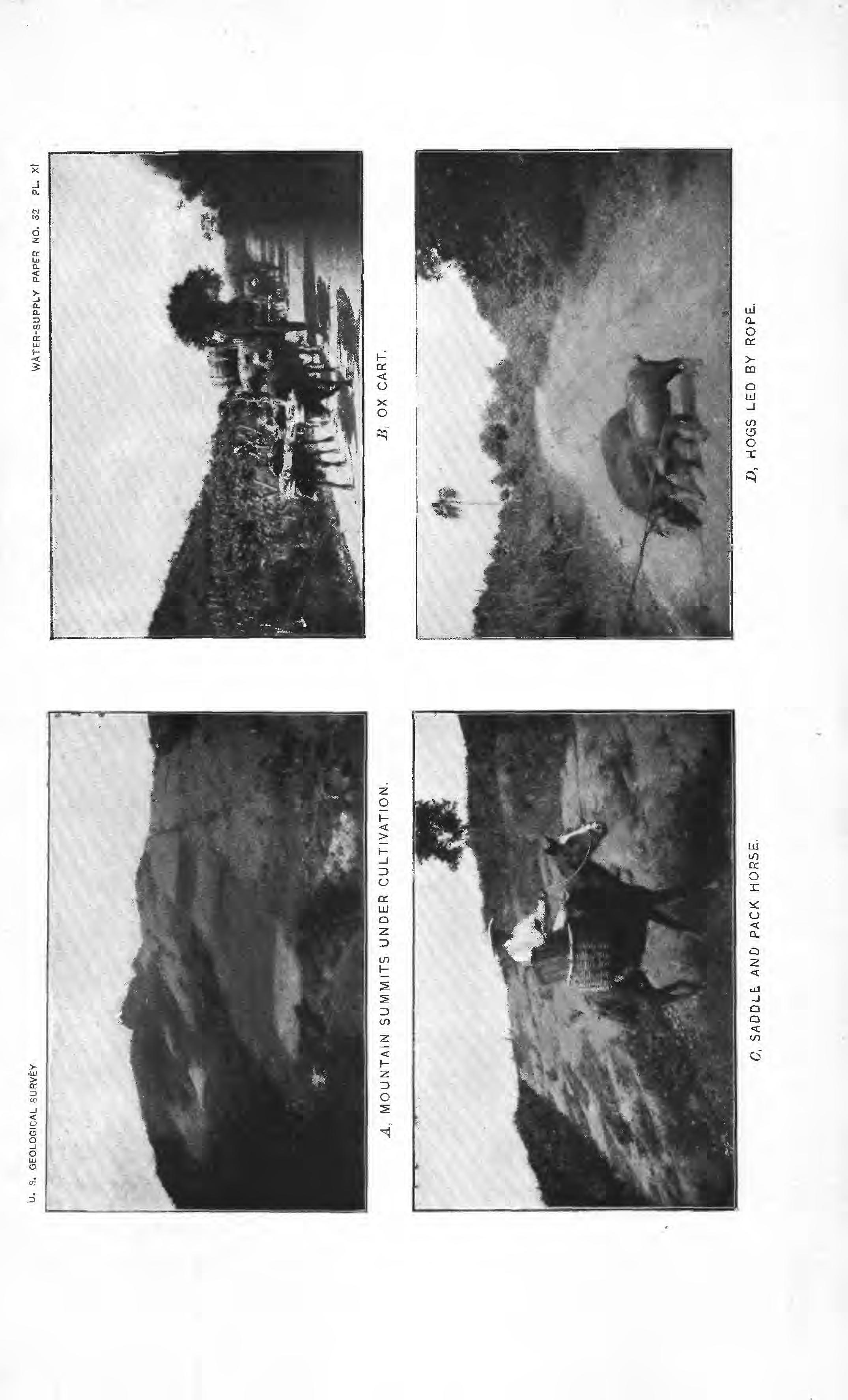
There are two other distinct types of agricultural lands on the island. These are found in a few small alluvial valleys on the upper courses of the rivers, as at Caguas (see PL IV, _B), Cayey, and Sabana del Palmar, and in the main mass of fruit and coffee land on the slopes, reaching even to the crests of the highest summits of the sierra. The mountain valleys appear frequently to have been old abandoned lake -beds, and are extensively cultivated in forage grass and in tobacco. The most interesting agricultural feature of the island is, however, the steep slopes of the main cordillera, which are everywhere cultivated and are mantled with sufficient depth of soil to give firm hold to the luxuriant vegetation with which they are covered. (See PL XI, A; text fig. 8, on page 37: and PL IV, O.)
The soil of Puerto Rico, in physical and chemical composition, is of two kinds. It is these differences which furnish the most radical changes in flora observed on the north and on the south side of the island, modified, of course, by altitude to a less extent and by precipitation to the greatest extent. Primarily the soils are either of calcareous or of clay origin, the result of decomposition of the underlying rock.
32 WATER

U. S. GEOLOGICAL SURVEY WATER-SUPPLY PAPER NO. 32 PL. X A, RIVER BED AND MASONRY CONDUIT. S, IRRIGATION DITCH IN EARTH.
(7, SUGAR LAND NEAR PONCE, Z>, GUINEA GRASS, CAGUAS VALLEY.
Geologically, the mountain portion of the island is, according to Mr. R. T. Hill, composed chiefly of basic igneous rocks, as tuffs, conglomerates, and ledges or dikes of diorites and hornblende-andesite, all of volcanic origin. Included within this mass and interbedded with it are two distinct limestone formations; one, found near the crest of the island, is a black shaly limestone of over 1,000 feet in thickness; the other is alight-gray crystalline limestone, which outcrops on the southern and western slopes between Ponce and Cabo Rojo. The soils which weather from the former of these limestones furnish the best tobacco lands. Those which have weathered out of the second of these limestones are of little agricultural value, and on them the indigenous flora is noticeablydifferent from thatgrown on the former:
The main mountain masses are heavily covered with soil of a deepred arenaceous clay. This is the result of decay of the volcanic rocks which have been rapidlydecomposed under the influences of perpetual moisture and heat. To the tenacity of this soil the interior of Puerto Rico owes its power to retain vegetable growth on its deep slopeseven after they have been deforested.
The soils of the playas are entirely of alluvium washed down from the mountain formations and mixed with detritus from the adjacent limestone hills. These playa soils are reddish-black in color, except in the northwestern portion of the island, where they are derived from decay of the pepino hills and are black and calcareous. These playa soils are of sandy loam, well adapted to root penetration, and excellent for cultivation because they are open, porous, and therefore well drained.
OLD FIELDS AND FERTILIZERS.
In manyportions of Puerto Rico the lands havebeen overcultivated without fertilization. Such lands are now abandoned and have somewhat the appearance of the "old fields" of the Southern States. On the limestone hills of the southern coast they are covered with a short grass and resemble the sheep-grazed hills of New Mexico and western Kansas. (PL VI.) Theseworn-out lands, or, as theyare called in the British West Indies, "ruinates," are found scattered throughout the country, and furnish one of the most interesting problems connected with scientific agriculture in the opportunities theypresent for reclamation.
Excellent fertilizers are found well distributed throughout the island, and the value of these will ultimately be ascertained and their use extended. The most abundant of these is a greensand marl of Eocene age, found extensively in the northwestern portion of the island, between Lares and San Sebastian, and alsoin the neighborhood of Carolina, at the northeastern extremity of the island. This marl appears to be rich in phosphates and is not unlike in general appearance the marls of New Jersey. Next in value as fertilizers are large
WILSON.]
33
OLD FIELDS AND FERTILIZERS.
IRR 32 3
OF PUERTO EICO.
deposits of guano on Mona Island, just off the west coast, and smaller deposits in caverns on the west coast and near Ponce. Elsewhere throughout the island are great beds of shell and chalk marls and of lime phosphates. The lime marls are abundant everywhere around the coast, and gypsum marls occur in the neighborhood of Ponce.
AGRICULTURAL PRODUCTS.
The soil of Puerto Rico is so deep and fertile, the precipitation so abundant and well distributed, and the temperature, though tropic, so mild as to render it possible to cultivate almost all the land on the island. Moreover, almost every foot of it is now or has been under cultivation. It is essentially the land of the small farmer, because, limited as the island is in extent, the official records show that it is divided into 36,650 individual holdings. These are distributed as follows: Tobacco plantations, 66; cattle ranches, 240; coffee plantations, 360; sugar plantations, 435; small coffee farms, 4,185; small farms of mixed coffee, fruit, and vegetables, 4,375; small fruit and vegetable farms, 16,990. At least 21,000 of these holdings are of the smallest kind, being owned by the poorer peasantry. Such holdings range in size from 5 to 50 acres, rarelyreaching the latteramount. The remaining 5,000 holdings are from 100 to 5,000 acres or even larger. The greater proportion of these are relatively small and are devoted chiefly to the cultivation of coffee, the larger ones being mostly cultivated in sugar.
So fruitful are the soil and climate that the people pass an indolent and lazy existence, even to a greater extent than is observable elsewhere in Spanish America. Outside of the few large plantations the people are unacquainted with any agricultural implement other than the machete, a short thick sword, which serves all the purposes of scythe, brush hook, ax, hoe, and weapon of defense. Holes are scratched in the surface of the soil in which to plant seeds or transplant sprouts. Thereafter no attention is given to the crop until it becomes necessaryto gather the product either for domestic consumption or for exchange in the nearest village for such household necessities as the farm does not produce.
Abundant and well distributed as are the various crops, the island produces to but a fraction of its capacity. (See PI. XIII.) Thus far there has been no incentive to grow such products as would have value for export, and no means have been available and no forces at work to incite the ambition of the people, and thus give them some inducement to gain a better living. They know nothing of the higher arts of civilization, and if they had more wealth than they now possess they would not know how to use it. With the higher aims which will come from association with the more active, liberal, and highly civilized people of the United States, increased energy may be exerted in

34 WATER RESOURCES
[NO.32.
U. S. GEOLOGICAL SURVEY A, MOUNTAIN SUMMITS UNDER CULTIVATION, C Y SADDLE. AND PACK HORSE, WATER-SUPPLY PAPER NO. 32 PL. xl Z>, HOGS LED BY ROPE.
the near future in wresting from nature more bountiful and useful crops than are now cultivated.
At present such crops as are produced for exportation are limited almost exclusively to sugar and the by-products of the cane (molasses and rum), coffee, tobacco, and hides, in the order named. In value, however, coffee exceeds that of sugar in the ratio of three to one. Accordingto the Spanish Estadistiea General, the total exports for 1897 were valued at 118,574,678. These were distributed as follows:
Exports of principal articles from Puerto Rico, 1897. Cane sugar. ..........^. Coffee...---.---.-..-.---....-.......-..-.-.-.-. Tobacco.

Amount, in pounds. 125, 323, 589 25, 085, 069 51,097,823 6, 181, 771 823,108
Value. $4, 007, 999 403, 519 12, 222, 598 1,194,318 71,852 674,392 $18,574,678
In addition to the above there are several other articles of export which, like these, are all of agricultural origin. In order of importance they are: Honey, the value of the exported product being $517,746; wax; cattle, of which 3,180 head were exported; chocolate; straw hats; and a very small amount of fresh fruit.
From the above it is evident that the most valuable crop of the island is coffee. Next in importance ranks sugar and then tobacco and cattle. In addition there are cultivated, chiefly for domestic consumption, various cereals, lentils, potatoes, small vegetables, and fruits, as well as forage grasses.
Of domestic animals cattle are first in importance. These are of unusually large size, being far more powerful and heavier than any seen in Central or tropic South America or elsewhere in the West Indies, and in fact exceed in size the cattle of our Southern States. They have widespreacling horns and in general appearance they resemble the range stock of Texas and the uplands of Mexico. (See PI. XII, jB.) Horses are abundant, but are so diminutive in size as to scarcely deserve any other name than pony. They resemble in general appearance the ponies of Cuba, but though small they are exceedingly hardy and are excellent pack animals. (See PI. XI, C.)
All the heavy draft work of the island is done by oxen, which are yoked, not by the neck but by the horns, to heavy two-wheeled bullock carts made of mahogany and similar hard woods. (SeePI. XI, jB.) Off the roads, and these are but few and inferior in quality, all produce is hauled to the markets and purchases made there are carried
WILSON.] AGRICULTURAL PRODUCTS. 35
--.--....__.___--
..----_.-..--..------.-....-------..--Hides.... -._-_-----
Total ....................................
OP PUERTO RICO. [NO.
back to the mountain farms on the backs of the sturdy little pack horses which climb with sure foot the steep, wet, and slippery trails. (See PI. XI, (7.) The method of packing these animals is that commonly practiced in some portions of South America. Most burdens are carried, not by means of pack saddles or of aparejos and lash ropes, but in wicker-basket panniers, which are hung loosely over the backs of the animals. Sacks of coffee, however, are hung loosely by sling ropes. In this way they are loaded with 150 to 250 pounds of coffee or other burden and tramp with quick, short steps over the rugged trails.
In addition to cattle and horses a very few small mules are bred; the only other domestic animals are poultry, hogs, and dogs. Th® poultry are of inferior breed, being chiefly raised for the game cocks, which are used in the universal sport of the people. These and the hogs, which are also of small size and of poor breed (see PI. XI, D), thrive well, but are so few in number that fences are rarely built to restrain them. It is therefore a common sight to see hogs tethered by a string tied around one leg and attached to a tree or picket, and to see poultry tied in the same manner and forage much as do milch cews.

The various agricultural crops of importance are distributed in zones, depending on and clearly marking the variations in altitude, rainfall, and soil composition. Sugar cane is cultivated exclusively in the coast playas and in the parting valleys among the lower hills of the back-coastborder. It grows luxuriantly, the stalks being 10 to 15 feet inheightandoften 2£ inches in diameteratthe base. (See PI. XII, A. ) The cane is cut during the months of January to March, inclusive, and produces an average yield of 3 tons to the acre. It is the only crop except coffee, the latter to a more limited extent, which is cultivated with modern methods and harvested by the use of modern machinery. Heavy, imported metal plows, drawn by six to ten yoke of oxen, are used in tilling the soil and making the furrows, through which irrigation water is flowed. The cane is cut down with a blow of a machete, and the longer stalks cut into lengths of 3 to 4 feet by the same process. It is carted from the field to the sugar mill either in ox carts (see PI. XI, B) or occasionally on trains of cars, hauled by oxen over railways placed temporarily in various avenues through the cane fields (see PL XII, B). The roadbed of these tramways is laid permanently, but the rails and ties are moved about as required. The sugar mills are invariably substantial brick structures containing the most modern machinery, in which the cane is crushed, boiled, and evaporated. From the mills cane sugar of muscovada grade, molasses, and rum are shipped, the last being usually distilled in the same mills.
Tobacco of excellent quality thrives well everywhere. The best varieties, cultivated in sufficient quantities for export, are grown chiefly in the valleys and the river bottoms on the head waters of the Kios Loiza and Plata. The culture of tobacco is especially exten-
36 WATER RESOURCES
32.

U. S. 6EOL6GICAL SURVEY WATER-SUPPLY PAPER NO. 32 PL. xli A, SUGAR CANE. J?, TRAIN OF CARS LOADED WITH SUGAR CANE DRAWN BY OXEN. 0. COFFEE SHADE. D, SHELLING COFFEE.
AGRICULTURAL PRODUCTS.
sive in the valleys and on the mountain slopes about Caguas, Oayey, Comeiro, and Juncos. (See PL IV, B. ) Especially interesting is its cultivation on the steepest slopes of the higher hills. (See fig. 8.) Theregroupsof tentotwenty laborers may be seen clinginglike antsto the steep mountain sides, hoeing and weeding or gathering the crop. These tobacco fields are the best kept and the most industriously attended agricultural products observed on the island. The flavor of thetobacco grown in the regionnamed is excellent. Itissoldin Puerto Rico at about $25 to $30 per hundredweight. The larger portion of it is shipped to the United States and Europe, through Ciiba, where it passes as Habana tobacco of the highly prized Vuelto Abajo quality. In Habana it commands 1100 to $125 per hundredweight. Coffee is grown everywhere, on the island at altitudes above 1,000
feet. Ordinarily it is at present cultivated at too low an altitude to yield the best variety and so little attention is given it in the way of cultivation and fertilization that the yield is relatively small. At altitudes of 1,000 to 1,500 feet the average product is about 500 to 600 pounds per acre. Between 1,500 and 2,000 feet the yield is 600 to 800 pounds per acre. Above 2,000 feet yields of 1,000 to 1,200 pounds per &cre are occasionally obtained, for at such altitudes coffee is generally grown by the larger planters and under more intelligent supervision. The product would be greatly increased and the quality improved if better methodsof cultivation were employed and if the crop were more extensively grown on the higher summits. The coffee plant is very delicate and is invariably shaded by tall, wide-spreading trees, chiefly the guayava, guama, and inaga (see PI. XII, C), which are planted for this purpose, and only occasionally, as is the custom elsewhere in the West Indies, is the plant shaded by bananas and plaintains. These latter are, however, chiefly used as shade for the younger coffee plants before they reach the yielding age.

WII/SON.]
PIG. 8. Cultivated hill tops in Cayey tobacco district.
The coffee plant is not unlike a tall, slender currant bush in general appearance, though it is peculiarly devoid of leaves or branches. Several stems grow from one root, and these are but three-quarters to an inch in diameter at the base, although they are 8 to 12 feet in height. They put out little, short branches with small leaves, and on these branches grow the coffee beans with exceedingly short stems, so that they appear to cling closely to the wood. The coffee berry when ripe is not unlike a good-sized red cherry. The plant begins to bear after four years, and the berry is picked during the winter months, from October to February. It yields best in seven to eightyears and continues to produce for about thirty years. The berry is gathered chiefly by women and children, who empty their small basketfuls into
FIG. 9.
larger baskets or sacks, and these are carried by men to the drying platforms, where the coffee remains in the sunshine, but always protected from rain and night dew, until thoroughly dry. The drying platforms are of two general types. The first type consists of broad, level platforms of masonry, with smooth concrete surfaces on which the berries are spread out evenly and are hoed over, and from which they are gathered and placed under cover at night or when rain threatens. The second variety of platform, that used on the larger plantations, consists of large wooden trays about 8 by 12 feet. These rest on rollers which run on tracks in such manner that when it is necessary to place the coffee under shelter the trays are rolled under the coffee house; as the trays are but 5 to 7 inches in depth, they run one above another, so that usually three trays, and sometimes more,, are housed under one portion of the coffee house. (See fig. 9;) Not

38 WATER RESOURCES OF
[NO. 32.
PUERTO RICO.
Drying coffee on rolling platforms, Pietris Plantation, AdjuntasJ

U.S.GEOLOGICAL SURVEY WATER SUPPLY PAPER N° 32 PL. XIII. Jfebztivefycorrectonly. r* TUNA LEGEND cm en Coffee Sugar cane. Bananas,Oranges Grass Tobacco etc. Sketch confcur inVarval 500 FeeK
OF PUERTO RICO SHOWING DISTRIBUTION OF CROP
MAP
LANDS.
BY HERBERT M.WILSON.
AGRICULTURAL PRODUCTS.
infrequently coffee is dried in the streets or plazas by spreading it out on burlap sacking, which can be quickly gathered up in the form of a bag and carried away.
After drying, the berry is crushed in great wooden mortars with heavy wooden pestles, so as to break away the dried husk which incloses the coffee bean. (See PI. XII, D.) Where better managed this crushing is performed in a circular trough not unlike an arastra, by means of heavy wooden wheels which are turned by animal power and sometimes by water power. After crushing, the coffee is washed and screened to separate the bean from the husk. The former is usually double that is, there are two half beans within one berry. Not infrequently, however, it consists of one deformed bean which is egg shaped and smaller than the two halves. This variety is called "caricolillas," and is especially prized in European markets. The washed coffee beans are placed in airy rooms in the drying houses and thoroughly seasoned and dried before shipping.
The variety grown generally is of excellent flavor. As yet little of it reaches the American market, chiefly because of the export duty nowplaced on it and because it commands a much higher price in the European than in the American market. The better varieties are sold by the sack by commission merchants in Puerto Rico at 13 to 18 cents per pound. This is a higher price in Puerto Rico than is paid in New York by coffee importers for the best grades of Bogata, Caracas, and other fine Central American varieties. As it is not well known in the American market, importers will not offer more than 10 to 12 cents for it. Much of it, however, reaches the United States, chiefly that of the poorer grades, being shipped to Europe in transit. After it has remained some time in the bonded warehouses it is withdrawn under the names of Java and Mocha. The American coffee buyer purchases largely on the appearance of the bean, and accepts thatwhich has adull and lusterless appearance. In Europe, however, coffee having a bright gloss is preferred, and for this reason Puerto Rican coffee is at present extensively treated with a wash of gum arabic and charcoal or some similar preparation, which gives it this gloss. This process injures the sale of the article in the American market. Those who have used Puerto Rican coffee, however, insist that its flavoris equal to the best sold in the country, and that when better known it will command a higher price and will displace the very best of the Central American product. Other valuable agricultural products are forage plants. The most important variety is guinea grass, a succulent plant having a blade or leaf 2 to 3 feet in heightand fullyone-half inchin width. Ityields about 3 tons to the acre and grows quickly and luxuriantly. (See PI. XV, Z>, and PL X, Z>.) Cattle and horses thrive on it and on a nutritious, .leguminous plant called "malahojilla," which is a variety of the wild-pea pine. On the southern foothills the chief forage plant is

WILSON.]
39
OF PUERTO RICO.
[NO. 32.
a short, dry-looking grass, not unlike the Southwestern bunch or buffalo grass. (See PI. VI.) The leaf and stalk of maize and the pods of various acacias, which are gathered green, are also used.

Maize is grown extensively in the wide parting valleys in the southwestern portion of the island. In the same region and in the beds of many of the streams which flow into the west coast, lentils are grown in large quantities. There are a number of varieties of these, chiefly beans, includingthe green string bean and the white and liver-colored bean, which when cooked are the "frijole" of Spanish America and the "Boston-baked bean" of the United States. A lentil-like berry, which in appearance is between a pea and a small bean, and yet grows on a bush belonging to the acacia tribe, is the guadure, and this is very extensively grown for domestic consumption on the semihumid side of the island. It occurs in a pod about 3 to 4 inches in length on a bush 6 to 8 feet in height. Yams and sweet potatoes are grown extensively, generally for home consumption, and Irish potatoes thrive well, but are grown to only limited extent in some portions of the uplands. Among other small vegetables are tomatoes and red pepper.
Cotton seems to flourish well, though it is not cultivated in commercial quantities. The cotton plants noted were almost as large as apple trees, being from 8 to 12 feet in height, with a stem 2 to 3inches in diameter at the base. (See PL XIV, A.) The flowers and pods were numerous, and the latter well filled with a long staple cotton apparently as fine as the best grown in the Southern States.
A variety of upland rice peculiar to the island is cultivated in the interior hills, and grows without irrigation or inundation. At present but little is produced, because the Spanish have discouraged its cultivation in order to increase the importation of rice from Spain. A plant called the yautia is one of the staple vegetable foods of the people, and is grown on the humid side of the island in large fields, much as cabbage is cultivated in the United States. It is the Caladium esculentum, and grows to a height of 2 to 3 feet. It consists chiefly of wide-spreading, heavy, green leaves, 12 to 20 inches in length, in appearance not unlike those of the plantain. (See PI. XV, A.) These are stewed and eaten as is cabbage or spinach, or are boiled as is okra in soups.
Another staple food is the plantain, which is baked when green, and is the bread of the people. There are many varieties of plantains and bananas, both cultivated and wild. No attempt seems to have been made, however, to grow those varieties which are in favor in the markets of the United States or Europe, and none are, therefore, exported. This should become one of the greatest of the agricultural products of the island, both for home consumption and for export, when means of rapidly conveying the same to the coast are available through the construction of good highways, and when the people
40 WATER RESOURCES

U. S. GEOLOGICAL SURVEY WATER-SUPPLY PAPER NO. 32 PL. XIV A, COTTON PLANT. /?, MARKET SCENE, PONCE. C, LOGS OF AUSUBO EN ROUTE TO MARKET, D, REPAIRING MILITARY ROAD,
learn to produce such varieties as are in demand abroad. The seed stock at present used is poor and run out, the bananas yielding only 2 or 3 hands deep instead of 10 to 15 hands, as they must for export.
Bananas and plaintains are grown generally throughout the island. They are cultivated most extensively on the hill slopes, being rarely seen on the alluvial lands and in the valley bottoms. On the humid side of the island these plants are, with cocoanut palms, the most prominent features of the landscape. (See PL VII, B.) They are scattered on every hillside, being grown sometimes ia orchards, but more generally in various portions of fields with other crops and in gardens. On the arid side of the island they are seen less frequently and at the lower altitudes quite rarely.
Another of the more abundant and valuable fruit trees is the cocoanut palm. The fruit is large sized and well flavored, and extensively consumed when green. But little is exported, though the husks are, to a moderate extent. This tree also flourishes everywhere and produces well.
Oranges, like bananas and cocoanuts, grow wild and cultivated everywhere with great luxuriance; so also do lemons and limes. A cultivated variety of oranges, which is used to a small extent in shading coffee, is unusually juicy and well flavored and is the equal of the best produced in the United States. Yet none are exported, and such few as are gathered are a drug on the home market and are sold at the rate of from two to three for one cent.
Pineapples are cultivated to a slight extent, chiefly in the southwest, about CaboHojo. Guayavas alsoare chiefly grown inthe southwestern portion of the island, though they are not cultivated to the extent one would expect. From them is made guayava jelly, which is a popular confection with the inhabitants and finds also ready market in the United States. Less abundant are the aguacate or alligator pear (Persea), the guanavana, called in Central America " chiramolla " and "custard apple" (Anona); the mango, the mamey or bread fruit (Marnmea), and a variety of others. All of these fruits and vegetables are extensively consumed by the people and are for sale in all the city markets. (See PI. XIV, B.)

FORESTRY.
The forest resources of the island have been practically exhausted. The country has been so long densely inhabited and under cultivation that practically all the virgin timber has been removed, and some of the native trees are so rare that specimens of them can scarcely be found. Practically all of the more valuable hard woods, which are abundant in Haiti and eastern Cuba, are indigenous on this island. The whole surface of the country, especially on the higher mountain slopes, is well covered with trees. The woods consist chiefly of the artificial and natural shade trees, under which coffee is
WILSON.] FORESTRY. 41
OF PUERTO RICO. [NO. 32. planted. (See PI. XII, C. ) The more important of these trees are the guama (Ingalaurinea), guava (Ingavera), bucare (Eryfhrina bu&are), and maga (TJiespesia grandiflora). These trees are of little value for their lumber, as their trunks are but 4 to 7 inches in diameter, are not straight, and branch about 10 to 15 feet from the ground, reaching a height of 30 to 50 feet. The maga has some value for timber; the wood is hard, can be worked without great difficulty, and is used to a limited extent in the construction of furniture and for similar purposes.
The most abundant of the precious hard woods is the ausubo, resemblingteakormahogany. Trees of this kindare found in manyportions of tke island, and it is used extensively in making bullock carts, the spokes and poles of these being always of ausubo. It is also used for beams, rafters, and upright posts in buildings. Two varietiesof Spanish cedar, the hard and soft cedar, occur, but both are rare a 12-inch plank, 1 inch thick and 12 feet long, being valued in the mountains at $1. Another of the more abundant woods is the guaraguao, which is used chiefly in making board flooring and is valued at about 50 cents per plank. Another wood employed in board flooring is the capa prieta. An excellent furniture wood, strong and hard but very rare, is the capa blanca. The mauricio is a verydurable yellow wood used for parts of machinery, for the hubs of carts, and for similar purposes. A wood which does not easilydecay, and is therefore used for posts and such purposes as require insertion in the ground, is the higureillo. Among other of the native woods are the nonfragrant sandalwood, laurel, ucar, algarrobo, palosanto, and bamboo. (See PI. XV, B.}

All of these woods are so scarce, however, that the larger portion of the timber used in structures is imported. The most extensive import of wood is common spruce, hemlock, and pine from Nova Scotia. Many of the older buildings of the island are of native woods, but all of those which have been recently constructed have been built chiefly of imported lumber. Only two sawmills of any capacitywere seen on the island, one in San Juan and the other in Ponce, and both were engaged in cutting up cedarwood for cigar boxes and in making parts of wagons and of machinery from ausobo. In the mountains in a few places old-fashioned whipsaw pits were seen, at which mahogany planks were being cut out of rough logs. These were then hauled by horses over muddy trails for many miles to the cities in which they were to be used. (See PI. XIY, C.)
Aside from the few scattered hard-wood trees which grow on the slopes of the more inaccessible mountains there are a few rather extensive pieces of woodland. The most important of these is on the eastern end of the Sierra de Luquilla, which is heavily covered with virgin forest. East of Ponce, about Santa Isabel and Salinas and in the extreme southwest near Cabo Rojo, are some extensive areas of
42 WATER RESOURCES
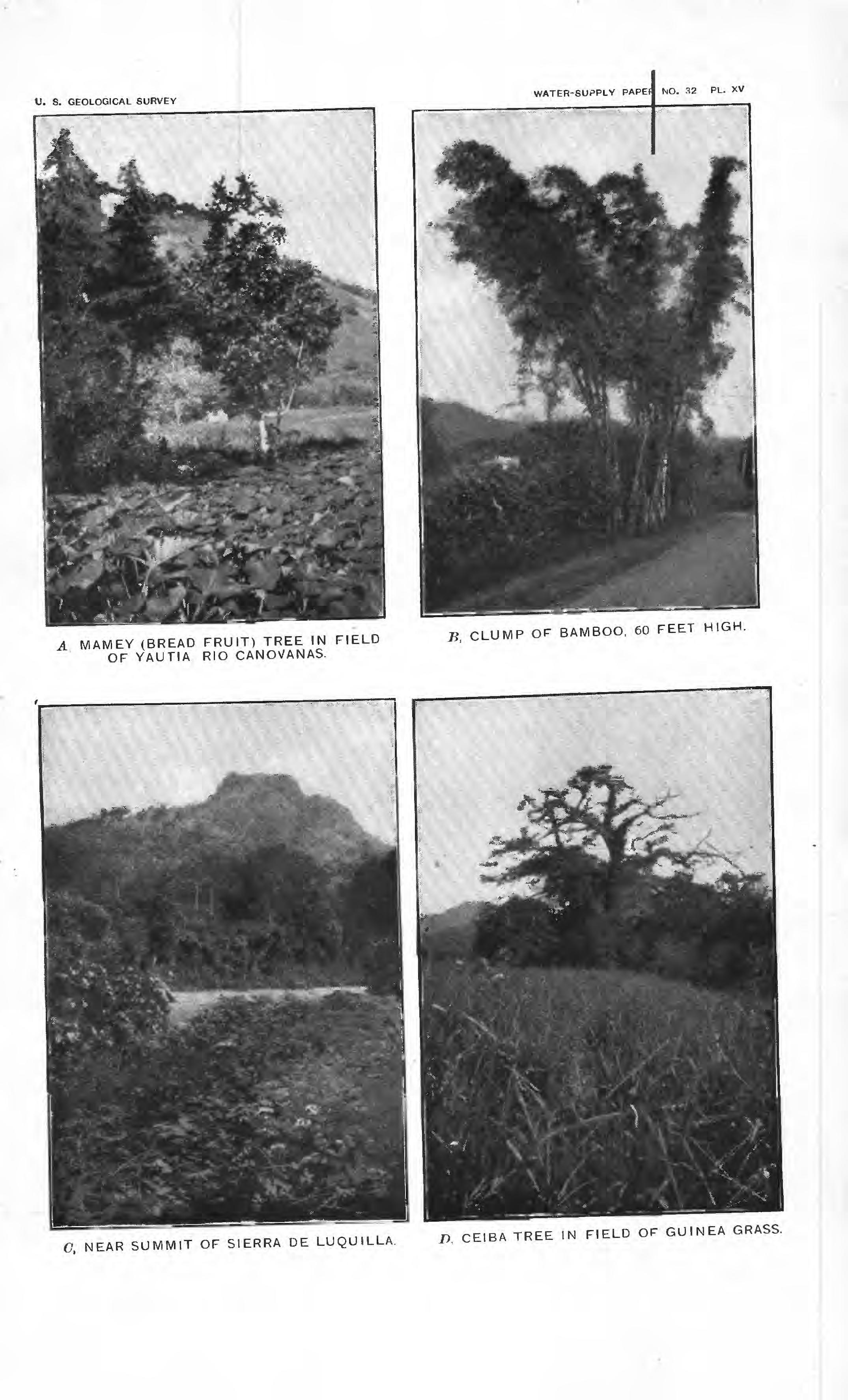 A MAMEY (BREAD FRUIT) TREE IN FIELD OF YAUTIA RIO CANOVANAS.
CLUMP OF BAMBOO. 60 FEET HIGH.
O, NEAR SUMMIT OF SIERRA DE LUQUILLA. D, CEIBA TREE IN FIELD OF GUINEA GRASS.
A MAMEY (BREAD FRUIT) TREE IN FIELD OF YAUTIA RIO CANOVANAS.
CLUMP OF BAMBOO. 60 FEET HIGH.
O, NEAR SUMMIT OF SIERRA DE LUQUILLA. D, CEIBA TREE IN FIELD OF GUINEA GRASS.
WATER POWER AND SUPPLY.
woodland. The amount of merchantable timber which is left, however, is too small to render this an important element among the natural resources of the island.
WATER POWER AND SUPPLY.
The volume of water available for utilization either as supply for domestic purposes in the various cities or for conversion into power through the agency of water wheels is relatively great. While this is especially true of the north side of the island, it applies also in a measurable degree to the south side, for, while on the latter side the streams do not discharge large volumes during the dry season, there is more water in them near their sources in the mountains than reaches the lowlands, because of loss through evaporation and percolation.

All of the cities of any size are provided with some form of domestic supply. At present, in San Juan, this is chiefly from rainfall. The same is true of most of the cities which are 011 the humid side of the island, though in some cases the rain water which is caught in tanks is supplemented by gravity supplies. In no city, however, ts there a water supply of modern type at all commensurate with the requirements of a tropic climate. Not only is the supply for domestic use insufficient in every case, but there is practically no supply available for fire engines, for the flushing of house plumbing, or for washing streets and flushing gutters.
A new water supply is being provided for the city of San Juan. This was commenced under the Spanish authorities and is now being^ pushed to completion by officers of the United States. It is well designed after severalyears of survey and investigation. The supply comes from the Rio Piedras, about 6 miles above San Juan, where it is diverted into a short canal, which carries it into settling reservoirs, each of which has a capacity of one and one-half days' supply, at the rate of 35 gallons per head. Thence the water flows into filter beds, whence it is pumped to a distributing reservoir 110 feet high. From this it will be conducted in underground mains and distributaries to the various houses in the ctty.
Ponce receives a gravity water supply from the Rio Portugues, whence it is diverted about 9 miles above the city and conducted in masonry conduits and underground iron distributaries to the more important streets. On a hill back of the hospital in the outskirts of Ponce is a small, covered, distributing reservoir. This has not been cleaned inmany years and is so foul that its use has been abandoned. Mayaguez, which is in fact the best provided city on the island, also receives a gravity supply. This is from the Rio Mayaguez, the perennial discharge of which is sufficient for the present requirements of the inhabitants.
WILSON.]
43
OF PUERTO RICO. [NO. 32.
Most of the smaller cities, as Aibonito, Adjuntas, Lares, etc., have gravitysupplies of water piped to them from neighboring streams, but the volume of water supplied is rarely greater than can be easily carried in a 2-inch pipe. Nodifficultyeither of an engineeringorfinancial nature should be encountered in supplying these cities with abundant quantities of wholesome, potable water. Near every city there is sufficient water available in one or more of the rivers, and this can invariably be diverted at sufficient altitude to permit its being carried by gravity into the cities. The natural conditions in nearly every case are such as should insure the procurement of such water supplies &t relatively small cost.
' The opportunities for the generation of power are also superabundant, and the use which has thus far been made of them is insignificant. The amount of water available for conversion into power is evident from a consideration of the discharge of the various streams, a»s already stated, and the great height from which the water falls in but comparatively few miles. Streams which have a minimum volume of 50 to 150 second-feet at an altitude of 1,000 to 1,500 feet fall to within 100 feet of sea level in a distance of 5 to 10 miles. Consequently there are many steep rapids, cascades, and high falls in their courses, and it is necessary to convey the water in flumes or ditches but relatively short distances to obtain such head as will produce all the power of which use can be made. Finally, the width of the banks of these streams within the mountain gorges is so small and their surfaces are composed so largely of rocks and bowlders that there will be little difficulty or expense connected with the diversion of the water through dams and head works. Already one American corporation has purchased and obtained control of one or more water powers on the Kios Plata and Arecibo. The amount of power which will be obtained from these has been estimated as from 500 to 1,000 horse-power per concession.
TRANSPORTATION FACILITIES.
The development of the agricultural resources of the island is necessarily dependent largely on facilities for transporting products to the coast for shipment and of returning thence purchases made in the coast towns. At present the island is less adequately provided with good wagon roads than is the more sparsely inhabited and most inaccessible portion of the mountainous Western States. There is but one good road across the island and some pieces of fairly good road around the coast. Thelatterare, however, disconnected. In addition, there are about the coast several long but disconnected pieces of .railroad. The railroads are of French construction and operation. They are of very narrow gage, 1 meter or less. There are about 140 miles of such railroad in operation, including a short stretch from San Juan eastward to Carolina; another from the same point westward
44 WATER RESOURCES

U. S. GEOLOGICAL SURVEY WATER-SUPPLY PAPER NO. 32 PL. XVI
P. MUDDY CART ROAD NEAR AIBONITO.
O, ROCKY CART ROAD NEAR LARES. >, RUTTED CORAL ROCK IN CART ROAD NEAR SAN SEBASTIAN.
to a little beyond Arecibo; a section between Aguadilla, Mayaguez, and Hormigueros; onebetween SaixSebastian andAnasco, and another from Ponce to Yauco. The locomotives are light, the cars small and of trifling capacity, and the trains run but once in every day or two and consist of but two or three cars.
The roads are divided into three classes: First, military roads, of which there are about 285 miles. These are all well graded and well surfaced with macadam and are kept in fairly good repair. (PL XIV, D.) Moreover, they cross the various drainage channels on well-constructed masonrybridges and culverts (see PL XVII, A), often girdling the mountain sides in great cuts, blasted out of the sides of the precipitous slopes (see fig. 10). Aside from the road from San Juan to Ponce, the other portions of this first-classroadare near the coast, including a stretch between Arecibo, Aguadilla, and Mayaguez; another between Mayaguez andYauco; and stillothers between Rio Piedras and Carolina and between Caguas, Juncos, Humacao, and Naguabo. A branch of the road which crosses the island extends from Cayeyto Guayama. Aside from this limited amount of first-class road none on the island is worthy of being called even second class, thoughsodesignated by the Spanish.

There are said to be about 100 miles of secondgrade road, including stretches between Arecibo, Utuado, Adjuntas, and Ponce, of which only the latter portion is in condition to carry even the roughest cart traffic. (See PI. XVI, A.) Anotherbit of cart road, overwhichonlythe lightest loads can be drawn by bullock, is between Aguadilla, San Sebastian, and Lares. (See PL XVII, B.)
The third class of roads, called cart roads, are officially stated as aggregatingover500miles inlength. None of these, however, is fitfor other traffic than that of pack animals. Even military roads furnish transportation facilities for only an extremely limited extent of coun-
WILSON.] TRANSPORTATION
45
FACILITIES.
FlG. 10. Rockwork near Aibonito, summit of military road.
OF PUERTO RICO.
try to either side. The moment one leaves such roads he is compelled to enter at once on trails which climb the precipitous mountain sides with extremely steep grades or descend into the deep stream gorges.
The great amount of rainfall and the peculiarly slippery and sticky character of the red-clay soil on the humid side of the island renders all roads except those near the southern coast and those which are macadamized littlebetter than impassable morasses. (SeePI. XVI, B. ) No wheeled conveyance can travel such roads unless they be provided with far better drainage than now. On the drier side of the island, especially over the coral formation at the western end, the roads are filled with great rocks and bowlders (see PI. XVI, (7), and in places the soft coral rock is worn into deep ruts, rendering the roads impassable now for carts. (See PI. XVI, D.) On these so-called cart roads even the sturdy pack animals have great difficulty in carrying relatively light burdens through clinging mud ankle deep, or over the bowlder and rock strewn surface.
As the bulk of the present transportation is on pack animals, which carry but 150 to 200 pounds a trip and return half laden, it is interesting to note the present price paid for handling freight in this manner. Between the more distant points over which pack journeys are made $1 per hundredweight is paid each way and 50 cents per hundredweight is the least rate, even for a very short haul. From the neighborhood of Adjuntas to Yauco and Ponce the rate is $1 per hundredweight. One of the largest coffee plantations on the island, that of Mariani Sons, pays from $1 to $1.50 per hundredweight for transportation. Those in the neighborhood of Lares pay as much as $2 per hundredweight for transportation to Mayaguez, and those of Tres Hermenos pay 75 cents per hundredweight. Sugar is conveyed from boiling houses to the nearest shipping points usually in 15-hundredweight hogsheads, which can be carried on bullock carts over the better roads found near the coasts. The cost for such haulage varies from 20 to 30 cents per hundredweight. Inferior as are the railroad facilities, the difference in price is shown by the fact that railroad carriage costs but two-thirds of a cent per hundredweight per mile.
The necessity for the development of a comprehensive system of first-class highways or railways is too evident to require furtherelaboration. Until such a system is in existence there is little hope for the development of any of the resources of the island except coffee and tobacco, which can be hauled at convenience, since they are not perishable, and sugar, which is grown only near the seacoast and at places convenient to shipping points. The most obvious direction in which improvement of internal means of communications should take place is in the construction of electric tramways as main arteries of traffic, supplemented by macadamized roads as feeders. Material for railway ballast and for road metaling is abundant in every part of the island. This consists chiefly of hard black limestone and of hard coral rock and bowlders.

46 WATER RESOURCES
[NO. 32.

U. S. GEOLOGICAL SURVEY WATER-SUPPLY PAPER NO. 32 PL. XVII
A, BRIDGE OVER RIO CANA NEAR CAGUAS.
B, ROCKY CART ROAD NEAR LARES.
INDEX.

Page.
Adjuntas, figure showing method of dryingcoffeeat..-.. 38 plate showing road near_. . 44 topography near. ................ 19
Adfuatas Pass, plate showing view near summit of 18 Agricultural land, types of _.......-... 33 Agricultural products 34-41 Aibonito, figure showing military road near............. ... .. .-.. 45 plate showing road near 44 topography and flora near........ _. 17,18
Aibonito summit, plate showing scenery south of.............................. 18 plate showing view between Cayey and................................... 18
Afiasco, Rio, measurements of 28 plate showing view of.... ........ . 28 plate showing hills along 18 Area of Puerto Rico ..............._.__ 11 Areeibo, section north and south through. 13 Arecibo. Rio, measurements of 27 Ausubo, extent and use of........ 42 logs of, en route to market, plate showing .--...-.--.--__-..--. .-----.--- 40
Bamboo, plate showing clump of.. 42 Bananas, cultivation of.. ...... -... 41 Blanco, Rio, measurements of............... 27 Caguas, plate showing bridge over Rio Cananear.................. ... 46 topography near....................... 16-17
CaguasValley, plateshowingElMonteand 18 plate showing guinea grassin.... 32 Caguitas, Rio,measurements of....... 26 Calabasas, Rio, measurements of. 27 Cana,Rio, plate showing bridge over, near Caguas.._........._........ .. 46
Canovanas, Rio, measurements of.......... 26 plate showing character of *........_. 16 plateshowing field of yautia near... 42 topography along the... -... ' 16 Carite, Rio,measurements of..... 26-27 Carolina, plate showing view ot Rio Loiza near........................ ......., . 26
Carolina Plain, plate showing 16 Cattle, exports of............. .. 35 kinds of,andworkdoneby....... 35-36 Cayey. plate showing view between Aibonito summit and......... ... . 18 topography near ...__.. .......... 17
Cayey divide, plate showing view west from.____.. .._..._......... 16
Cayey tobacco district, figure showing cnl tivated hilltops in 37 Cedar wood, value of....._................ 42 Ceiba tree, plate showing................... 42 Climatologyof Puerto Rico............... 21-24
Page.
Coamo, Rio, measurements of. .......... 27 Coastal topography of Puerto Rico 14-15 Coast, south, widthand topography of..... 18 Cocoanut palm, cultivation of ... 41 Coffee,exports of...... .... 35 method of cultivating and drying, and value of ._......-------- . 37-39 figure showing method of drying, at Adjuntas.................-......- 38 plate showing method of shading 36
Coffee shelling, plate showing ........ 36 Conduit for irrigation, figure showing. 31 Conduit, plate showing river bed and masonry 32
Cordillera Central, coast limestone hills, and playa at Ponce, view of, 15 course and altitude of.. ...... 13,14 Cotton, cultivation of............. ....... 40 Cotton plant, plate showing. ... 40 Crops in Puerto Rico, map showing distribution of-.................... -...- 38
Culebrina, Rio, measurements of 28 Dam, wing, plate showing. ... . 28 Descalabrado, Rio, measurements of 27 plate showing view of.... ...... ... 28 Ditch, irrigation, plate showing 32 plate showing regulator gate and 28 Drainage and hypsometric map of Puerto Rico.................................. 11
ElGuilarte, height of..... .. .......... 14 El Monte, plate showing CaguasValleyand IS ElYunque, height of........................ 12 plate showing view of-.... -... 16 section north and south through... 12 Exports from Puerto Rico....... 35 Fertilizers in Puerto Rico . . 33,34 Flora, arid, near Lares, plate showing...-. 26 diversity of,in Puerto Rico.... ... 23 Foothills of Sierra de Luquilla, plate show^ing 16 Forestry of Puerto Rico 41-43 Grass, varities grown in Puerto Rico 39-40 Guayama,sectionnorth andsouth through 13 Guinea grass,'Caguas Valley, plate showing 32 plate showing field of. 43 Hacienda Perla, rainfallat.......... ..-. 22 temperature at ....... ... 24 Hansard, A. C,, observations made by... 22,23 quoted on height of El Yunque......... 12 Harrington, M. W., meteorologic data collected by........- ..-- 22 Hides, exports of . ...'... 35 Hill, R. T., quoted on erosion in Puerto Rico.............- -. - -.-- 21 quoted on rocks of Puerto Rico ....._ 33 Honey, exports of... ... -- 35 47
Page.
Hydrography of Puerto Rico............. 24-38 Hypsometric and drainage map of Puerto Rico.................................. 11
Irrigation ditch, plate showing............. 32
Irrigation in Puerto Rico. ................ 38-33 Jacaguas, Rio, irrigation from the....... 30-33 measurements of.__.................. 37 plate showing view of, nearJuana Diaz 16 Juana Diaz, plate showing barren hills near......-.-........-..-.-.-......... 20
plate showing view of Rio Jacaguas near--....-..--.............-.-....... 16
Land, agricultural, types of __ ._ __ 33
Lares, plate showing arid flora near....... 38 platesshowing roads near __ 44,46 plate showing views near........_.... 33 topography near .....__............ 19-30 Las Cruces, altitude of...................... 17 LaTorre, altitude of........................ 19 plate showing viewfrom summit of.... 33
Loiza, Rio, measurements of _ 36 plate showing view of ......._........ 36 plate showing playa at mouth of....... 16 Luquilla, Sierra de. (See Sierra de Luquilla.)
Magueyes, Rio, measurements of .......... 37 Mamey tree, plate showing................. 42
Mango trees bent by wind, plate showing. 18 Map, drainage and hypsometric, of Puerto Rico.-.----.-.....-.....---........... 11
Map showing distribution of crops in Puerto Rico.-_-_.__---.........-..... 38
Market scene, Ponce, plate showing ....... 40 Mayagnez, water supply of................. 43 Military road. (See Road, military.)
Molasses, exports of ....._..._..__.... 35 Mountain ranges of Puerto Rico. _..... 11-14
Mountain summitsundercultivation, plate showing... ............ 34'
Orangos in Puerto Rico...._.,. ........ 41
Ox cart, plate showing.. ... ____....... 34
Pack animals, cost of transportation by... 46 Pack horse, plate showing.....--..---.-.... 34
Parting valley about and hills back of Yauco,plate showing......... .... 36
Piedras, Rio, water supplyfurnished by... 43 PUoneillos, near Lares, view of.... 30
Pineapples,cultivation of........ ... 41
Plantain, cultivation of........._........ 40-41 Plata, Rio, measurements of................ 27
Playa at mouth of the Rio Loiza, plate showing.... 16
Playa, description of.................... 16
Ponce, plateshowingmarketscene at...... 40 plate showing sugar land near.. ..... 32 plate showing view of Rio Portugues at..................................... 26
section north and south through... 13 topography near ...................... 18-19 watersupply of.......... ............. 43
Portugues, Rio, plate showing view of..... 36 measurements of........................ 37
Portugues, Rio, water supply furnished by............ .............................. 43
Precipitation in Puerto Rico............. 33-34 Products, agricultural, of Puerto Rico... 34-41 Railroads in Puerto Rico ....... ....... 44-4S Rainfall in Puerto Rico................... 32-24 Regulator gate and ditch, plate showing - 28 Rice,cultivation of........._._'.......... 40 Rio. (See next word of name.) Road, military, near Aibonito, figure showing ..........................._..... 45 from San Juan to Ponce, course of and topographyalong. 16-18 plate showing method of repairing..... 40 Road near Adjuntas, plate showing....._ 44 Road near Aibonito, plate showing 44 Road near San Sebastian, plate showing... 44 Roads in Puerto Rico 45-46 Roads near Lares, plates showing........ 44,46 San Juan, plate showing bent mango trees at-.-.-......-.. .--.---.-......-.., 18 rainfall at...........................----- 23 section north and south through 13 water supply of 43 San Sebastian, plate showing road near.... 44 Section north and south through El Yunque ........._ 12 Section north and south through Ponce 13 Section north andsouth throughSanJuan. 13 Sierra de Cayey, cotirse and elevation of 12 Sierra de Luquilla, extent and course of... 12 plate showing foothills of............... 16 plate showing view near summit of.... 48 topography of 16 Siphon, figure showing inverted, carrying ditch under military road .......... 30 Soils of Puerto Rico....................... 33-33 Streams, numberand measurements of.. 24-28 Sugar, exports of. 35 method of cultivating.-...--.---.-----.- 36 Sugar cane, plate showing.... ........-..-.. 36 trains of cars loaded with, plate showing 86 Sugar land near Ponce, plate showing.. 33 Temperature of Puerto Rtoo.... . .-.. 24 Tobacco, cultivation and. value of. .-.. Sf ^ exports of ........__ ._ ___........ 35 figure showing' cultivation, oa hflltops in Cayey district ................... 37
Topographic features of PnertaEico.... 11-21 Trade winds, influence of........ ...... 21-32
Transportation facilities in Puerto Rico. 44-46 Turabo, Rio, measurements of............. 26 "Water power and supply inPnertoEico. 43-44 "Winds, trade, influence of 21-33 "Wing dam, plate showing.......--.-.... 28 Woods of Puerto Rico ......-.......-_-.-. 43-43
Yahueca, Rio, measurements of............ 27 Yauco, plate showing parting valleyabout, and hilts back of..................... 28 Yautia, plate showing field of .... ......... 43 cultivation of................... 40

48 INDEX.
1895.
Sixteenth Annual Report of the United States Geological Survey, 1894-95, Part II, Papers of an economic character, 1895; octavo, 598 pp.
Contains a paper on the public lands and their water supply,by P. H. Newell, illustrated by a large map showing the relative extent and location of the vacant public lands; also a report on the water resources of a portion of the Great Plains, by Robert Hay.
A geological reconnoissance of northwestern Wyoming, by George H. Eldridge, 1894; octavo, 72 pp. Bulletin No. 119 of the United StatesGeological Survey; price, 10 cents.
Contains a description of the geologic structure of portions of the Bighorn Range and Bighorn Basin, especially with reference to the coal fields, and remarks upon the water supply and agricultural possibilities.
Report of progress of the division of hydrography for the calendar years 1893 and 1894, by F. H. Newell, 1895; octavo, 176 pp. Bulletin No. 131 of the United States Geological Survey; price, 15 cents.
Containsresultsofstream measurementsat variouspoints,mainly within the arid region, and records of wells in a number of counties in western Nebraska, western Kansas, and eastern Colorado.
1896.
Seventeenth Annual Report of the United States Geological Survey, 1895-96,Part II, Economic geology and hydrography, 1896; octavo, 864 pp.

Contains papers on "The underground water of the Arkansas Valley in eastern Colorado," by G. K. Gilbert; "The water resources ofIllinois," by Frank Leverett; and "Preliminary report on the artesian areas of aportion of the Dakotas," by N. H. Darton.
Artesian-well prospects in the Atlantic Coastal Plain region, by N. H. Darton, 1896; octavo, 230 pp., 19 plates. Bulletin No. 138 of theUnited StatesGeological Survey; price, 20 cents.
Gives a description of the geologic conditions of the coastal region from Long Island, N. Y., to Georgia, and contains data relating to many of the deep wells.
Report of progress of the division of hydrography for the calendar year 1895, by F. H. Newell, hydrographer in charge, 1896; octavo, 356 pp. Bulletin No. 140 of the United States Geological Survey; price, 25 cents.
Contains a description of the_ instruments and methods employed in measuring streams and the results of hydrographic investigations in various parts of the United States. 1897.
Eighteenth Annual Report of the United States Geological Survey, 1896-97, Part IV, Hydrography, 1897; octavo, 756 pp.
Contains a "Report of progress of stream measurements for the year 1896," by Arthur P. Davis; "The water resources of Indiana and Ohio," by Frank Leverett; "New developments in wellboring and irrigationin SouthDakota," by N. H. Darton; and "Reservoirs for irrigation," by J. D. Schuyler. 1898.
Nineteenth Annual Report of the United States Geological Survey, 1897-98, Part IV, Hydrography, 1899; octavo, 814 pp.
Contains a "Report of progress of stream measurements for the calendar year 1897," by F. H. Newell and others; " The rock waters of Ohio," by Edward Orton; and "Preliminaryreport on the geology and water resources of Nebraska west of the one hundred and third meridian," by N. H. Darton. 1899.
Twentieth Annual Report of the United States Geological Survey, 1898-99, Part IV, Hydrography, 1900; octavo, pp.
Contains a "Report of progress of stream measurements for the calendar year 1898," by F. H. Newell, and "Hydrography of Nicaragua," by A. P. Davis.
WATER-SUPPLY AND IRRIGATION PAPERS, 1896-1899.
This series of papers is designed to present in pamphlet formthe results of stream measurements and of special investigations. A list of these, withother information, is given on the outside (or fourth) page of this cover.
Survey bulletins can be obtained only by prepayment of cost, as noted above. Postage stamps, checks, and drafts can not be accepted. Money should be transmitted by postal money order or express order, made payable to the Director of theUnited States Geological Survey. Correspondence relating to the publications of the Survey should be addressed to The Director, United States Geological Survey, Washington, D. C.
IRR32
WATER-SUPPLY AND IRRIGATION PAPERS.
1. Pumping water for irrigation, by Herbert M. Wilson, 1896.
2. Irrigation near Phoenix, Arizona, by Arthur P. Davis, 1897.
3. Sewage irrigation, by George W. Rafter, 1897.
4. A reconnoissance in southeastern Washington, by Israel C. Russell, 1897.
5. Irrigation practice on the Great Plains, by E. B. Cowgill, 1897.
6. Underground waters of southwestern Kansas, by Erasmus Haworth, 1897.
7. Seepage waters of northern Utah, by Samuel Fortier, 1897.
8. Windmills for irrigation, by E. C. Murphy, 1897.
9. Irrigation near Greeley, Colorado, by David Boyd, 1897.
10. Irrigation in Mesilla Valley, New Mexico, by F. C. Barker, 1898.
11. River heights for 1896, by Arthur P. Davis, 1897.
12. Water resources of southeastern Nebraska, by Nelson Horatio Darton, 1898.
13. Irrigation systems in Texas, by W. F. Hutson, 1898.
14. Newtests of pumps and water liftsused in irrigation, by O. P. Hood, 1898.
15. Operations at river stations, 1897, Part I, 1898.
16. Operations at river stations, 1897, Part II, 1898.
17. Irrigation near Bakersfield, California, by C. E. Grunsky, 1898.
18. Irrigation near Fresno, California, by C. E G-runsky, 1898.
19. Irrigation near Merced, California, by C. E. Grunsky, 1899.
20. Experiments with windmills, by Thomas O. Perry, 1899.
21. Wells of northern Indiana, by Frank Leverett, 1899.
22. Sewage irrigation, Part II, by George W. Rafter, 1899.
23. Water-right problems of Bighorn Mountains, by Elwood Mead, 1899.
24. Water resourcesof the State of NewYork, Part I, by G-eorge W. Rafter, 1899.
25. WaterresourcesoftheStateof NewYork, Part II, by GeorgeW. Rafter, 1899.
26. Wells of Southern Indiana (continuationof No. 21), byFrank Leverett, 1899.
27. Operations at river stations, 1898, Part 1,1899.
28. Operations at river stations, 1898, Part II, 1899.
29. Wells and windmills in Nebraska, by Erwin Hinckley Barbour, 1S99.
30. Water resources of the Lower Peninsula of Michigan, by A. C. Lane, 1899.
31. Lower Michigan mineral waters, by Alfred C. Lane, 1899.
32. Water resources of Puerto Rico, by Herbert M. Wilson, 1899.
In addition to the above, there are, in various stages of preparation, other papers relating to themeasurement of streams, the storage of water, the amount available from underground sources, the efficiency of windmills, the cost of pumping, and other details relating to the methods of utilizing the water resources of the country. Provision has been made for printing these by the following clause in the sundry civil act making appropriations for the year 1896-97:

Provided, That hereafter the reports of the Geological Survey in relation to the gaging of streams and to the methods of utilizing the water resources may be printed in octavo form, not to exceed 100 pages in length and 5,000 copies in number; 1,000 copies of which shall be for the official use of the Geological Survey, 1,500 copies shall be delivered to the Senate, and 2,500 copies shall be delivered to theHouse of Representatives, fordistribution. (Approved, June 11,1896; Stat. L., vol. 29, p. 453.)
The maximum number of copies available for the use of the Geological Survey is 1,000. This quantity falls far short of the demand, so that it is impossible to supply all requests. Attempts are made to send these pamphlets to persons who have rendered assistance in their preparation through replies to schedules or who have furnished data. Requests made for a certain paper and stating a reason for asking for it are granted whenever practicable, but it is impossible to complywith general demands, such as to have all of the series sent indiscriminately.
Application for these papers should be madeeitherto members of Congress orto THE DIRECTOR, UNITED STATES GEOLOGICAL SURVEY, IRR 32 Washington, D. C,