Education
Lebaneese American University
Bachelor of Architecture(B.Arch)
Minor in History
GPA 3.62/Distinction
Abu Dhabi International School
September 2018-present
September 2014-June 2018
British External Examination Certificate(IGCSE/IAL)
Experience
Bernard Khoury/DW5
Intern November 2022-present
-Prepared and assisted in the drafting of construction drawings for J2 Business and Retail Center in Kuwait.
Hala Younes, Architecture and Landscape
Intern July 2022-October 2022
-Developed and detailed pitched roof structure and attic
-Coordinated on site, to ensure smooth construction
-Worked on “Beyrouth une Ville a L’Oeuvre” exhibition in collaboration with Institut Francais and L'agence SEURA Architectes
-Developed diagrams, maps, and drawings for the exhibition
-Assisted in organizing and planning of exhibition, including designing the floor plan and layout
Lawand Land Consultant
Intern November 2021-present
-Contributed to the design of a villa in Bhamdoun from schematic design phase to construction design phase.
-Assisted in completing files and documents for licenses and permits
LAU Fabrication Lab
Technician assistant
-Part of Work-Study Program
September 2018-March 2020
-Assist technician in metal/woodwork, 3D printing, and laser cutting
-Oversee and ensure student safety
Softwares
Adobe Illustrator
Adobe Photoshop
Adobe InDesign
Autocad Rhinoceros 3D
Ahmad Al Bissani
Architecture Student Beirut, Lebanon bissaniahmad123@gmail.com +961 76 798747
Sketchup Autodesk 3ds max Lumion Grasshopper 3D V-ray
Workshops
-Organized by MIT’s City Form Lab , AUB, and Dar.
-Discussions on research conducted on the public realm, walkability and pedestrian conditions in Beirut, with aim to propose solutions for a network of pedestrian friendly network of streets.
A’al Autostrad
January 2022-June 2022
-Part of Design Studio 8, in collaboration with ENSA-Val de Seine and Lebanese Embassy in France.
-Conduct an urban analysis and survery on Beirut-Jounieh Highway
-Propose architectural and urban solutions at different scales
International Studio Grasshoper and Rhino 3d Workshop
Exploration of Paris’s architecture and urban form, through a 2 week trip, that included a series of visits, tours, and lectures
Formal Tectonic and Mechanisms Workshop
Beirut Community Street Workshop July 2022 June 2022 January 2022 March 2019
Exhibitions
Institut Francais’s Beyrouth une Ville a L'oeuvre
Rez de Ville
LAU Foundation Program Exhibition
Design 2 Project
LAU DAID Online Exhibition
Design 5 Project Design 6 Project Design 8 Project
September-October 2022
May 2019
Decemeber 2020 May 2021 May 2022
Table of Content
Exhibited Work+ Research
3al Autostrad
Design Studio VIII Spring 2022(Year 4) Rez-de-Ville, research with Hala Younes (At Institut Francais’s Beyrouth une Ville a L'oeuvre) September-October 2022
Final Year Project Research
Recovering Landscapes
Design Studio VIIII Fall 2022(Year 4)
Other University Projects
Computer Technology Institute
Design Studio VI Spring 2021(Year 3)
Machine for Contemplation
Design Studio VI Fall 2021(Year 4)
Year 1+2 2018-2020
3al Autostrad
Design Studio VIII Spring 2022(Year 4)
Rez-de-Ville, research with Hala Younes (At Institut Francais’s Beyrouth une Ville a L'oeuvre) September-October 2022
3al Autostrad, a research studio by Hala Younes on the Beirut-Jounieh Autostrad. The studio started as part of Design Studio VIII at LAU, where each student was tasked with a comprehensive survey of the ground condition, commercial activity, and existing public transport of a selected strip between Beirut-Jounieh, each student later developed a vision for mobility along the Autostrad and a public transport hub. The work of the studio was developed further and exhibited at Rez de Ville as part of Institut Francais’s Beyrouth une Ville a L'oeuvre.
Survey
Charles Helou Station-Beirut River
Mapping of commercial activity
LAU Design Studio VIII
Mapping of type of ground
LAU Design Studio VIII

AUTO KHALED
Beirut-Jounieh Highway a peculiar dysfunctional corridor.
Bellow an analysis, research, and mapping of the highway as it leaves Beirut: commercial activity, type and condition of ground, and road network.
 M CHORABATI
Exhibition
Rez-de-Ville
The original vision of a freeway linking Beirut to the North, has become a congested urban corridor bordered with dense commercial activity on both sides. The illustration to the right showcases the realities of these commercial activity and how they function in terms of the automobile, in a car-centric environment.

Building typology on the relation of car traffic to commercial activity
Illustrated by Author Rez de VillePRIMARY BUS STATION
Connection between regional bus, local bus, and tram service
PRIMARY BUS STOP Connection between local bus, and tram service OTHER BUS STOP OTHER TRAM STOP REGIONAL

Urban and landscape intention at city scale






Urban block axonometric
LAU Design Studio VIII
The strategy adresses the parameters at multiple scales, at a metropolitan level a public transport system masterplan is proposed, utilizing multiple forms and types of vehicles, connecting cities from within, but also regions.
At a city level, the project chooses the areas around Beirut Rivers, proposing strategy to connect these neighborhoods, Dora, Burj Hamoud, Mar Mkhael, and Karintina, and make them more walkable, green, and friendly.
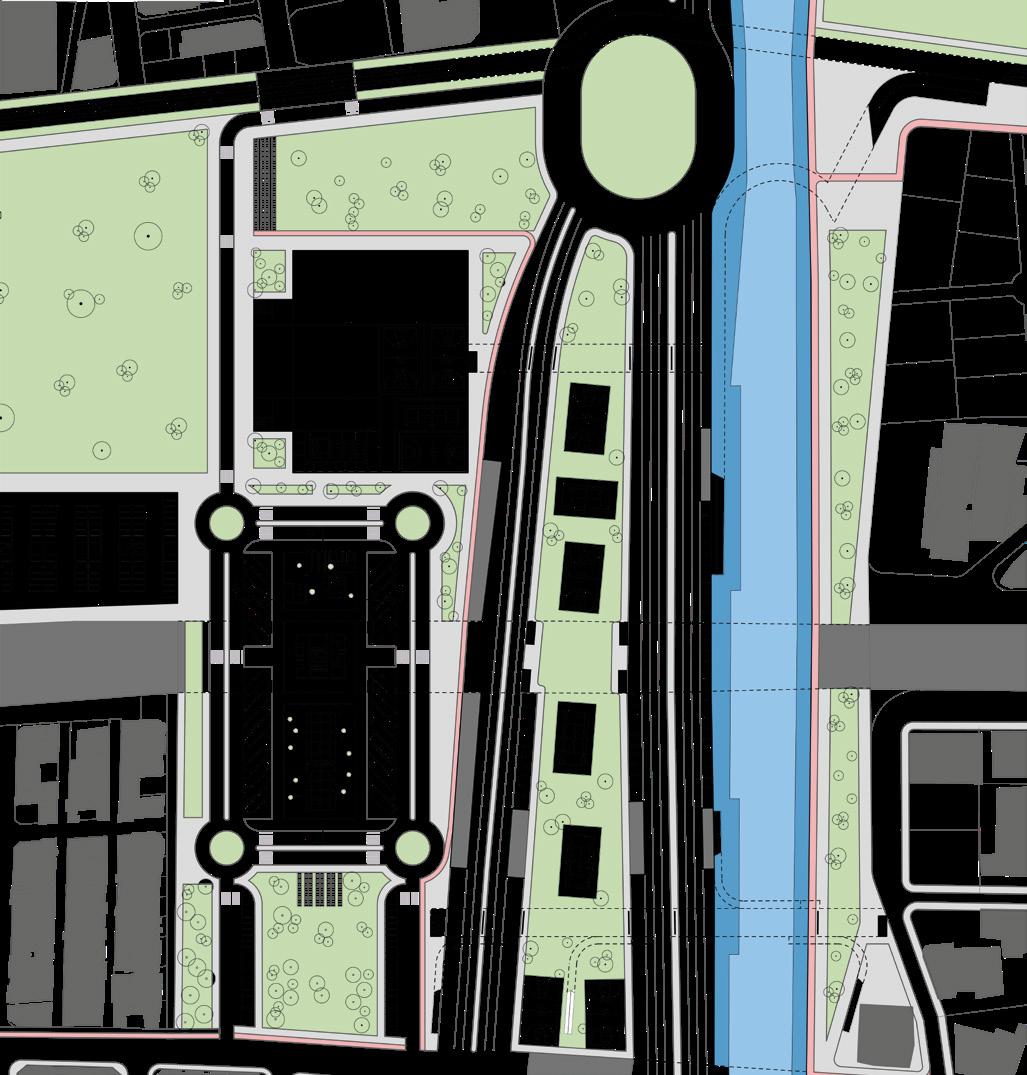
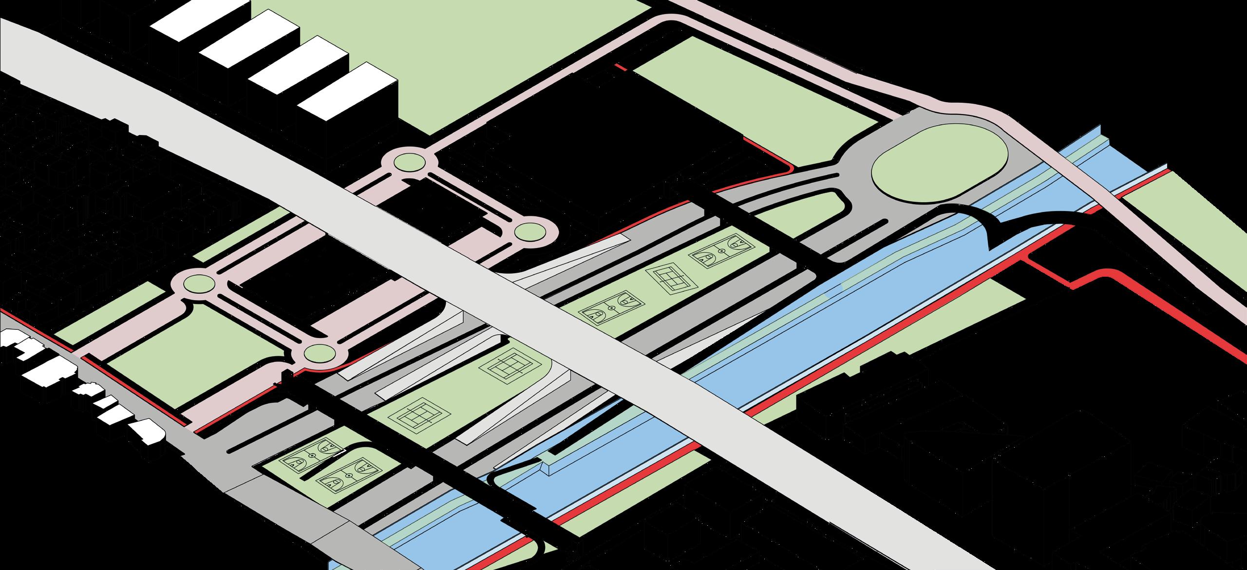
Finally, the station proposed is located at the strategic point were the autostrad crosses 2 other major roads and Beirut River. The hub will be located under the highway on vacant, left-over lands around Forum Du Beyrouth(convention center) and the river. The hub introduces diverse programs: such as, transportation hub, sport facilities, green space, and offices.
EXISTING HIGHWAY
The station benefits from the highway as a canopy, hosting the programs under. The area around the station is pedestrian and public transport only with a series of platforms, bus routes, and green spaces to allow the circulation of passengers on and off the vehicles.
To ensure connection of neighborhoods and easy pedestrian access extensive sidewalks, bike lanes, parks, and pedestrian bridges are planned around the station.
+LIBRARYCO-WORKING
TICKETING FOODHALL
extendplanetocreatecanopy house3functions
Exploded axonometric of architecture and concept of station LAU Design Studio VIII
createbusstreetnetworkandpassengerplatform
Plan of station and surronding landscape

Final Year Project Research
Recovering Landscapes
Design Studio VIIII Fall 2022(Year 5)
Urban Sprawl and Landscape along Beirut River Beirut Landscape Heritage Typologies Survey of Hazmieh Intention and Strategy
Water
URBAN SUBURBAN RIVERSIDE STREET HIGHWAY NATURAL INDUSTRIAL UNKNOWN
Beirut and its Eastern Suburbs Sprawl
Edge Landscape along Beirut River
Watershed Municipal border
Direct contact between river and vegetation
The research explores the relation between cities and landscapes, starting off with Beirut and being aware of its endless sprawl. However, recognized a unique phenomenon, of great potential, the leftover agricultural land along Beirut River as it curves east.

Urban Sprawl and Landscape along Beirut River
Suburb fabric part of vegetation edge
Next, after assessing the edge condition along the river, a unique site is found near the end of the concrete canal, where the river is liberated from traffic and built-up land and the wild valley reaches the river.
Liberated river edge from street and building Axonometric of context around Beirut RiverWhile the heritage in traditions, customs, and architecture is valued, we rarely appreciate the heritage in our landscapes. Thus, to be able to recover our dying landscape an awareness of the diverse landscapes of Beirut is required.
In reference to the work of Jala Makhzoumi, the first set of landscape typology can be understood in parallel to the devalopment and urbanization of Beirut. Before the late nineteenth century Beirut was a small walled city surrounded by miles of agricultural land, thus Beirut was surrounded by a landscape of bustans, a purely productive landscape with a small dwelling on the side.

With the devalopment of the port and the economic prosperity of Beirut, suburban expansion is witnessed for the first time. The erection of standalone houses, usually in the central hall style, surrounded by gardens. These house gardens showcase a shift in the concept of landscape, from a purely productive one to one that also incorporates pleasure. Now, gardens are not just spaces for cultivation, but also spaces of dwelling and the enjoyment of ornamental and scented varieties of plants.
With the continued prosperity and accumulation of greater wealth by Beiruti families. They started to erect palaces, obviously surrounded by gardens. However, unlike previous typologies, these palace gardens were instead inspired from Italian and French garden, with purely imported foreign variety of plants and landscapes, solely for pleasure.
However, with continued modernization of Beirut, house gardens and fields as a landscape became less prevalent and instead landscapes are now defined as being within an urban context, they can be exemplified by the following typologies. Apartment Building Gardens, which are composed of vegetation along the sidewalks, the gate, or setbacks of buildings. Parks, or a public green
space. And finally, Institution gardens, or greenery and vegetation surrounding institutions such as churches, universities, or other governmental buildings.

Street/car relam
Pedstrian path
Unobstructive/burried wall
Obstructive wall/high Urban edge of plot Plot
Productive agriculture field surronding Beirut
Strategic lands overlooking Beirut, so Arslanion set base to protect city, during Abbasid time and later dynasties.
Up to the 1970s, area purely productive feudel agricultural land
Hazmeih
The French construct a stone road to Damascus
In the late 19th century waves of migration towards agricultural lands of Hazmieh, mainly from Bsous, Keserwen, and Jezzine.
The French construct a railroad to Damascus
Construction of Jisr El Bacha in 1878 by the Othman Rustom Bacha, it would collapse in stages from 1953 till 1956
Assessment of Edge Condition
late 1980s
LEBANEESE CIVIL WAR
Creation of the municipality of Hazmieh
In Ecochard and Chamoun Plan for Greater Beirut of 1964, Hazmieh and Baabda zoned as suburb hill estates and Mkalles as industrial.
Beirut River canalized
Decree issued for new zoning and parcellation over the hills of Hazmieh to allow real-estate exploitation and urbanization.
Substantial urbanization to Hazmieh in full effect
First portion of the new highway opens, Emile Lahoud Highway, a coridor from Karintina to Sin El Fil.
New highway extended to Fayadieh, were it meets orignal road, that also underwent widening
Spinneys opens
City centre mall opens
Lebanese goverment announces IAURF Plan, a transportation masterplan Continued urbanization and real estate interest
The assessment of the unique liberated edge led to research and survey of the greater context surrounding the valley, mainly the suburb of Hazmieh. Moreover, the specific edge where the suburb meets the valley presents an interesting case of porosity. The porosity is experienced due to 2 reasons, firstly,
Survey of Hazmieh
Valleywithvegetationinbetween2edges


Axonometric of Edge Porosity in Hazmieh
the buildings being raised on pilots, allowing for continuous view of the valley and surrounding. In addition, the steep topography and the unique way the buildings in the neighborhood respond to the slope, by a reliance on retaining walls and the staggering of apartments above and under the street level.
Urban Sections 1/500


Connect the 2 edges Exsiting vegitation and farming activity
The proposed intervention main concern will be recovering this unique landscape along the Beirut River valley, physically, through creating a typology that connects the 2 edges, following the topography, and prompting and enhancing existing agriculture and expanding it. However, the approach to agriculture will not be limited to productive farming, but expanded culturally, by addressing a mission of cultivating an awareness towards nature and reintroduce these activities towards the public, reviving the historic agricultural landscape heritage.
Thus, the intervention will be conceived as a series of public spaces and promenades, interwoven through agricultural activity, allowing people to go on journeys of exploration of these landscapes. Additional research, pedological education, and public amenities programs will be integrated, to further promote the journey of recovering an awareness toward nature.
GREENHOUS SE ROF NOITAROLPXE+CIBUP

Other University Projects
Computer Technology Institue
Design Studio VI Spring 2021(Year 3)
The project was approached with 2 goals in mind, minimizing the building footprint to maximize spaces for the community and public, and creating inspiring spaces for students.
Thus, a long mass running along the whole plot was decided upon, as it allows the city to flow into the plot, by creating a park that continues along the neighborhood. This form is also able to host all the technical programs required, such as classes, labs, and workshops.
Masses were then critically removed to create courtyards, atriums, and public passageways to host the public and students in between the served spaces and around the building, allowing the city to further flow into the institution.
Site terraced to follow existing topography
Total area=1500m2
Process of concept in axonometric
Mass setbacked to create sidewalks
Mass pushed to south and east edge to create open public space,
Exploded axonometric of public space and voids
Mass extruded and recessed to maintain existing mass-void relation
Ground floor punctured to maintain connection between 2 sides
Ground floor plan


The building host a series of complex technical educational rooms, but also voids for public. Thus, the choice of envelope needs to be able to host all these spaces in harmony. As a result, a claustra skin was chosen, that wraps around the whole building and provides a spectrum of enclosure from fully interior closed classrooms to semi-enclosed public exterior space.
Diagram of relation of structure and skin on form
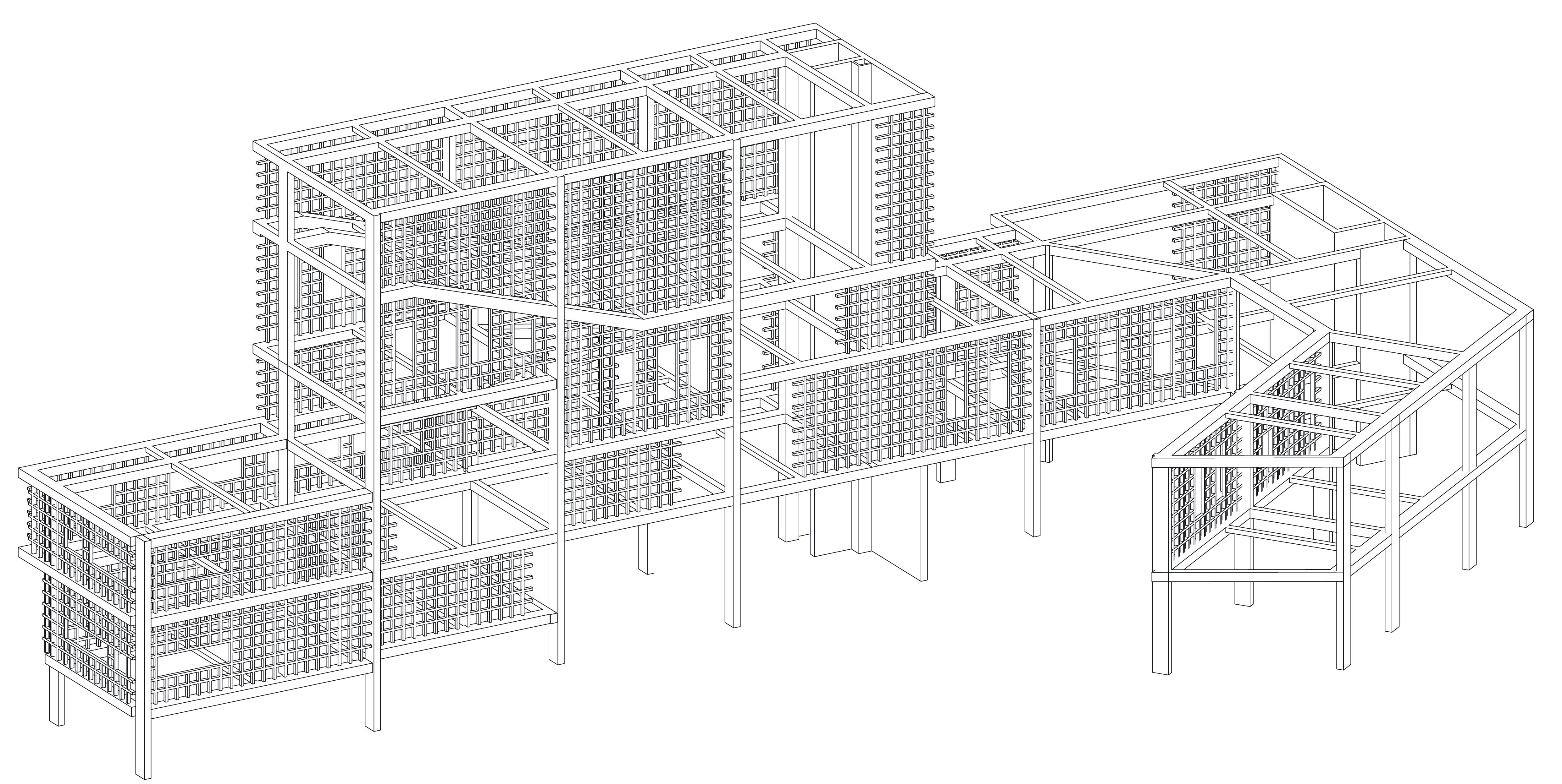


Wall section and detail of rendered elevation

Bathroom enlarged drawing Plan and section


Basement plan for construction

Opening Detail Plan, section, elelvation


Other University Projects
Machine for Contemplation
Design Studio VII Fall 2021(Year 4)
self
intellect nature
CONTEMPLATION
As people escape the city to the countryside, they transform to a lifestyle of contemplation, exploration through observation. The project aims at achieving this state, by promoting contemplation of the trilogy, self, intellect, and nature.
................
The contemplation of the trilogy is put in context, by achieving 3 respective actions: composition, discussion, and cultivation. The architecture is designed to prompt these activities also with its respective trilogy, towers of cells, floating plates, and cluster over land.
PURPOSE TRILOGY
ARCHITECTURE
self composition tower of cells intellect discussion floating plates nature cultivation cluster on land
C O M P O S I T I O N D I S C U S S I O N C U L T I V A T I O N
self in isolated towers intelect in floating plates nature in cluster over land
Circulation over floating bridges
PUBLICROOFOF DISCUSSIONCELLRESIDENTS SERVICES
DUPLEXCELLS CIVICSPACEOF DISCUSSION ACESSTO STREET+VILLAGE
STUDIOSPACE WORKSHOP
Circulation as penetration of layers of function
PRODUCTION+WORK+ STORAGEFACILITIES
Exterior circulation around facilities
Exploded axonometric of project
Other University Projects
Photography and Drawing Year 1
To Offend or To Defend Design Studio 1B(Year 1)
Boundary-less Housing Design Studio II(Year 2)
Year 1+2 2018-2020
Selection of work


Selection of photographs

To Offend or To Defend Design Studio 1B Fall 2018(Year 1)
Projectiles and their dynamic trajectory imply images of aggression and war; thus they suggest notion of attack, destruction, and offense. As a result, such gestures, influenced by the memory of war and aggression, generate an opposite reaction of protection and defense. The sculpture aims at expressing both contradicting notions simultaneously, to produce a conflicting ambiguous dialogue between offense and defense. diverse programs: such as, transportation hub, sport facilities, green space, and offices.


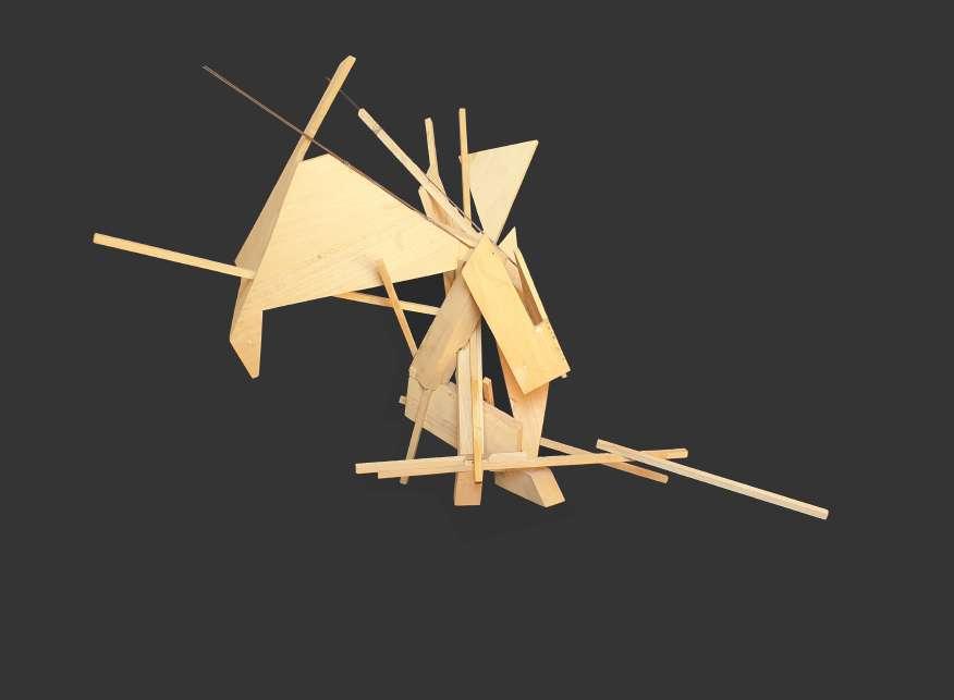 Sculpture in wood and metal
Sculpture drawing in ink on parchment
Sculpture in wood and metal
Sculpture in wood and metal
Sculpture drawing in ink on parchment
Boundary-less Housing
Design Studio 4
Spring 2020(Year 2)
of openings in elevation
PRECEDENT ANALYSIS OF SEIJO TOWNHOUSES-SANAA


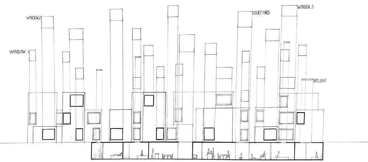

The project is an exploration of strategies to replicate a unit to create systems of architecture and thus a building, a machine.
The architecture aimed at creating spaces that defy the commoditization and commercialization of housing through real estate, by creating units that are free, flexible and with minimal boundaries, using split-levels and terraces.
Model of unit Plan of Machine

Model of Machine

Circulation diagram
When the issue of replication and strategies was introduced, the same notions were applied on the machine and enhanced, by replicating the units in a matter that they appear as an extension of 1 another, sharing public spaces and appearing as 1 continuous boundary-less whole.


Ahmad Al Bissani
Architecture Student Beirut, Lebanon bissaniahmad123@gmail.com +961 76 798747
