
Recovering
Landscapes
Year Project Research Design Studio VIIII Fall 2022(Year 5)
Urban Sprawl and Landscape along Beirut River Beirut Landscape Heritage Typologies Survey of Hazmieh Intention and Strategy Final
Water
URBAN SUBURBAN RIVERSIDE STREET HIGHWAY NATURAL INDUSTRIAL UNKNOWN
Beirut and its Eastern Suburbs Sprawl
Edge Landscape along Beirut River
Watershed Municipal border
SUBURBAN RIVERSIDE
HIGHWAY NATURAL INDUSTRIAL
BEIRUT-TRIPOLI HIGHWAY ARMENIA STREET YEREVAN BRIGDE SIN EL FIL/HABRTOUR URBAN
STREET
UNKNOWN
HAZMIEH-MKALES/JISR EL BACHA
ARMENIA STREET
YEREVAN BRIGDE
SIN EL FIL/HABRTOUR
HAZMIEH-MKALES/JISR EL BACHA
Building Built up land Agriculture land Unknown/leftover natural land
Direct contact between river and vegetation
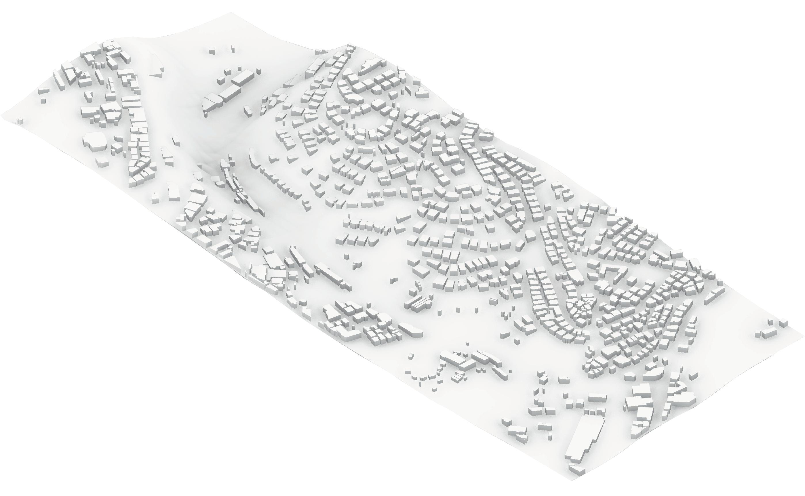
The research explores the relation between cities and landscapes, starting off with Beirut and being aware of its endless sprawl. However, recognized a unique phenomenon, of great potential, the leftover agricultural land along Beirut River as it curves east.
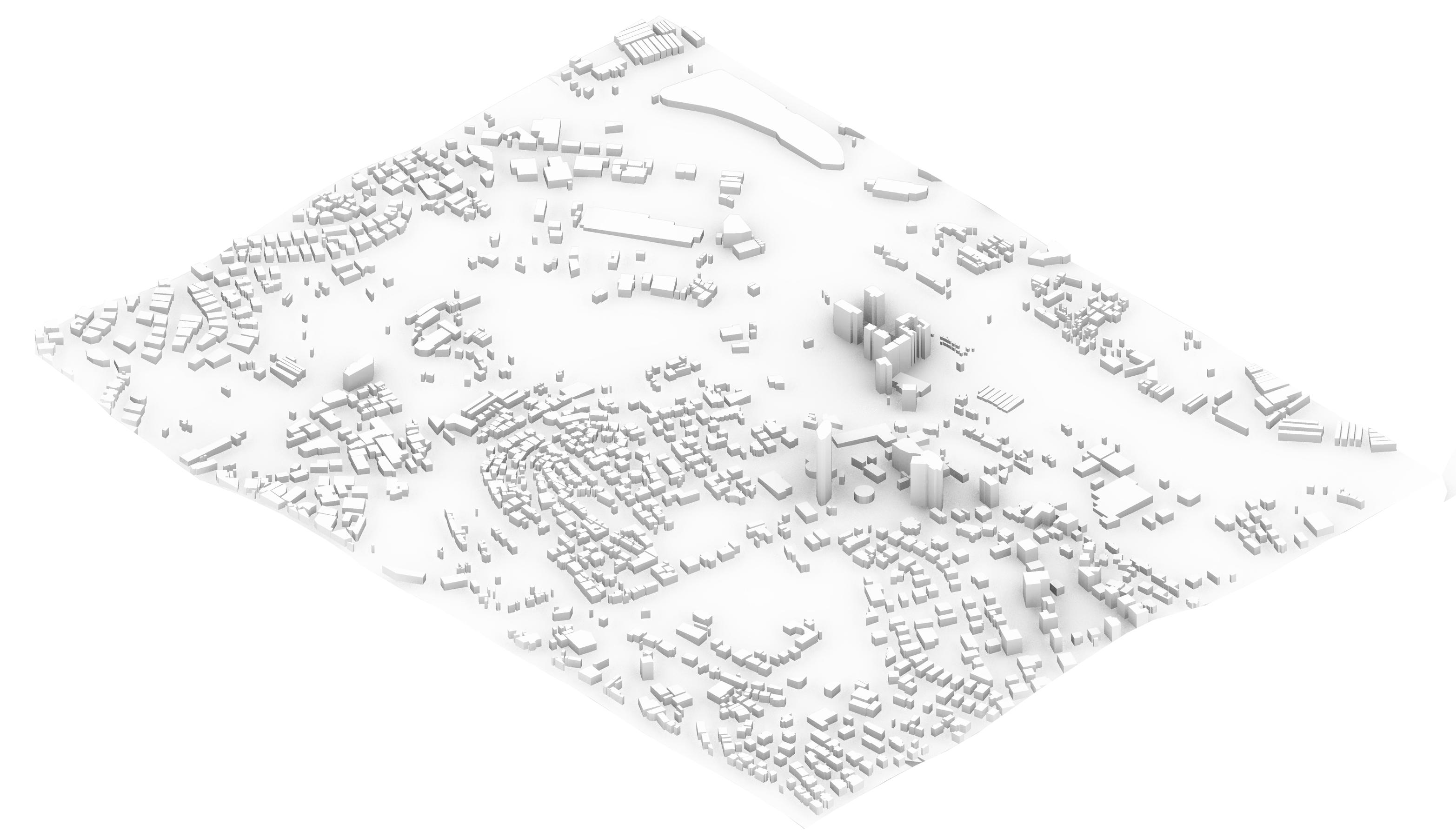
Urban Sprawl and Landscape along Beirut River
Suburb fabric part of vegetation edge
Next, after assessing the edge condition along the river, a unique site is found near the end of the concrete canal, where the river is liberated from traffic and built-up land and the wild valley reaches the river.
Liberated river edge from street and building
Axonometric of context around Beirut River
While the heritage in traditions, customs, and architecture is valued, we rarely appreciate the heritage in our landscapes. Thus, to be able to recover our dying landscape an awareness of the diverse landscapes of Beirut is required.
In reference to the work of Jala Makhzoumi, the first set of landscape typology can be understood in parallel to the devalopment and urbanization of Beirut. Before the late nineteenth century Beirut was a small walled city surrounded by miles of agricultural land, thus Beirut was surrounded by a landscape of bustans, a purely productive landscape with a small dwelling on the side.

With the devalopment of the port and the economic prosperity of Beirut, suburban expansion is witnessed for the first time. The erection of standalone houses, usually in the central hall style, surrounded by gardens. These house gardens showcase a shift in the concept of landscape, from a purely productive one to one that also incorporates pleasure. Now, gardens are not just spaces for cultivation, but also spaces of dwelling and the enjoyment of ornamental and scented varieties of plants.
With the continued prosperity and accumulation of greater wealth by Beiruti families. They started to erect palaces, obviously surrounded by gardens. However, unlike previous typologies, these palace gardens were instead inspired from Italian and French garden, with purely imported foreign variety of plants and landscapes, solely for pleasure.
However, with continued modernization of Beirut, house gardens and fields as a landscape became less prevalent and instead landscapes are now defined as being within an urban context, they can be exemplified by the following typologies. Apartment Building Gardens, which are composed of vegetation along the sidewalks, the gate, or setbacks of buildings. Parks, or a public green
space. And finally, Institution gardens, or greenery and vegetation surrounding institutions such as churches, universities, or other governmental buildings.
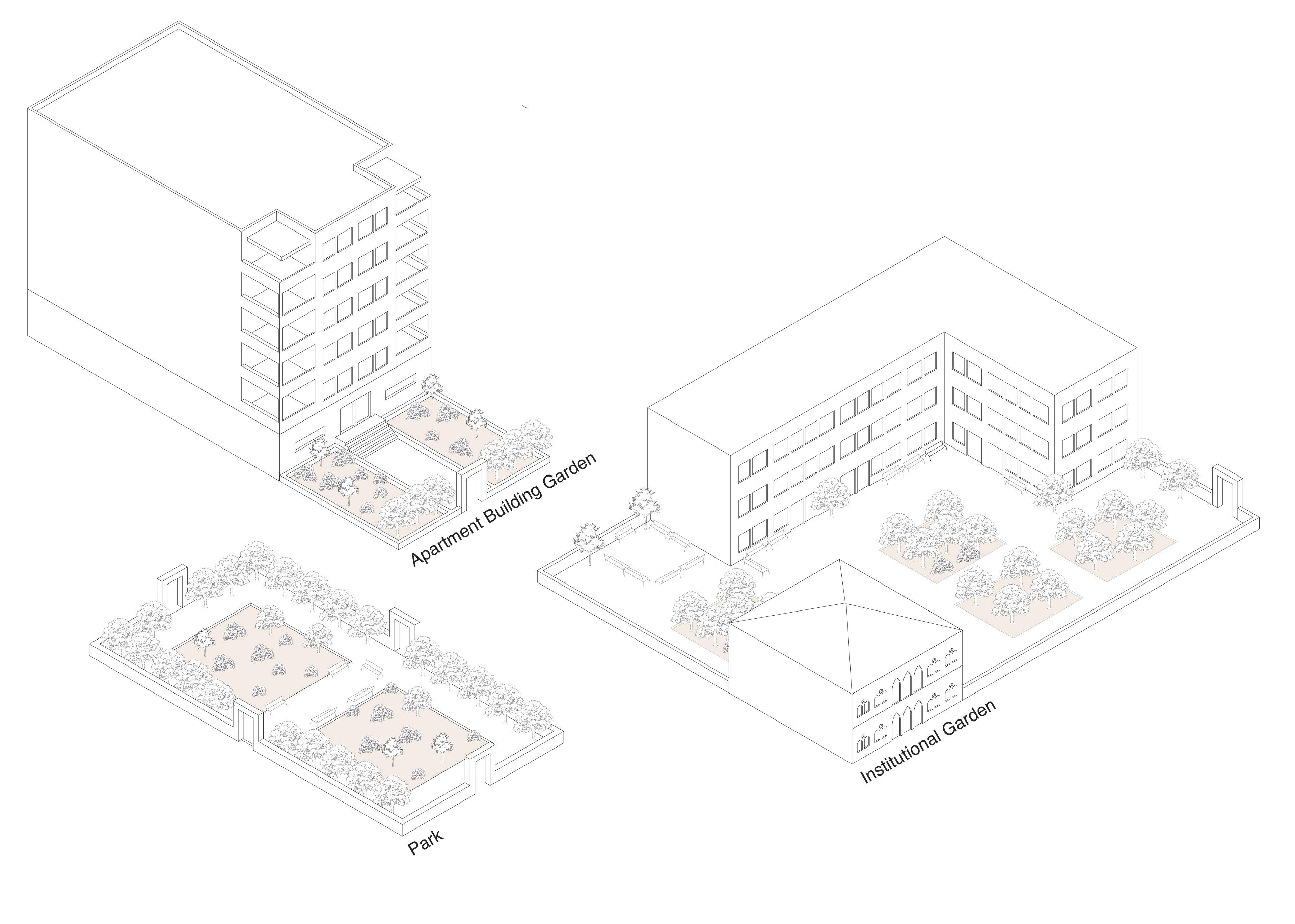
Beirut Landscape Heritage Typologies
Street/car relam
Pedstrian path
Unobstructive/burried wall
Obstructive wall/high Urban edge of plot Plot
Productive agriculture field surronding Beirut
Strategic lands overlooking Beirut, so Arslanion set base to protect city, during Abbasid time and later dynasties.
Up to the 1970s, area purely productive feudel agricultural land
Hazmeih
The French construct a stone road to Damascus
In the late 19th century waves of migration towards agricultural lands of Hazmieh, mainly from Bsous, Keserwen, and Jezzine.
The French construct a railroad to Damascus
Construction of Jisr El Bacha in 1878 by the Othman Rustom Bacha, it would collapse in stages from 1953 till 1956
Assessment of Edge Condition
late 1980s
LEBANEESE CIVIL WAR
Creation of the municipality of Hazmieh
In Ecochard and Chamoun Plan for Greater Beirut of 1964, Hazmieh and Baabda zoned as suburb hill estates and Mkalles as industrial.
Beirut River canalized
Decree issued for new zoning and parcellation over the hills of Hazmieh to allow real-estate exploitation and urbanization.
Substantial urbanization to Hazmieh in full effect
First portion of the new highway opens, Emile Lahoud Highway, a coridor from Karintina to Sin El Fil.
New highway extended to Fayadieh, were it meets orignal road, that also underwent widening
Spinneys opens
City centre mall opens
Lebanese goverment announces IAURF Plan, a transportation masterplan Continued urbanization and real estate interest
1863 1895 1878 late 1800s 1968 1964 1970 1943 1923 1998 1994 2013 2011 early2000s
2000 1958 COMMERCAIL APPARTMENT ON GF PILOTIS INSTITUTIONAL VILLA INDUSTRIAL/AGRICULTURAL <2000 2001-2005 2006-2010 2011-2015 >2016
Date of Construction Ground Floor Activity
Survey of
Historic Timeline
The assessment of the unique liberated edge led to research and survey of the greater context surrounding the valley, mainly the suburb of Hazmieh. Moreover, the specific edge where the suburb meets the valley presents an interesting case of porosity. The porosity is experienced due to 2 reasons, firstly,
Survey of Hazmieh
Valleywithvegetationinbetween2edges




Axonometric of Edge Porosity in Hazmieh
the buildings being raised on pilots, allowing for continuous view of the valley and surrounding. In addition, the steep topography and the unique way the buildings in the neighborhood respond to the slope, by a reliance on retaining walls and the staggering of apartments above and under the street level.
staggering
of appartments
suburban edge
river edge
Urban Sections 1/500


Connect the 2 edges Exsiting vegitation and farming activity


The proposed intervention main concern will be recovering this unique landscape along the Beirut River valley, physically, through creating a typology that connects the 2 edges, following the topography, and prompting and enhancing existing agriculture and expanding it. However, the approach to agriculture will not be limited to productive farming, but expanded culturally, by addressing a mission of cultivating an awareness towards nature and reintroduce these activities towards the public, reviving the historic agricultural landscape heritage.
Thus, the intervention will be conceived as a series of public spaces and promenades, interwoven through agricultural activity, allowing people to go on journeys of exploration of these landscapes. Additional research, pedological education, and public amenities programs will be integrated, to further promote the journey of recovering an awareness toward nature.
GREENHOUS SE ROF NOITAROLPXE+CIBUP


 Region of steep slope Follow geomtry in topography to generate form
GREENHOUSE +FIELD PUBLIC AMENTIES +MARKET AGRICULTURE PRODUCTION PEDALOGICAL EDUCATION RESEARCH CENTER PRODUCTION AND PLANTING INTEGRATE PUBLIC INSITU AND PRACTICAL WORK BOTANIC GARDEN+ FARMING+ PARK+EXPLORATION PROMONADE
NATURE PUBLIC COMMUNITY Strategy
Establish ecological awareness Community run and support Spread agriculture education and culture Commercial and economic viability BOTANICGARDEN+ PARK+ FARMING EXPLORATIONPROMONADE Expandstrategytosurrounding vacantparcels Restich2edges Maintainnaturalground andtopographyConnecttoexistingfabric andconnectwithneighborhood Intention and Strategy Axonometric of urban and landscape intentions
Ahmad Al Bissani
Architecture Student Beirut, Lebanon bissaniahmad123@gmail.com +961 76 798747


