AJINKYARAJ GHODNADIKAR
ARCHITECTURAL PORTFOLIO

SELECTED WORKS 2021
+91-8806974109 ajinkyaraj.1999@gmail.com
BASED IN PUNE, I HAVE COMPLETED B.ARCH FROM PUNE UNIVERSITY WITH FIRST CLASS DISTINCTION. THE VARIOUS EXPERIENCE GAINED FROM THE ACADEMICS, INTERNSHIPS AND COMPETITIONS HAVE FURNISHED MY ABILITY TO THINK CRITICALLY AND HAVE A PERSONAL VIEW POINT ABOUT THINGS ARE RELATED TO ARCHITECTURE. I SEEK A BASE CONCEPTUALIZATION, WHICH THEN GOES ON TO EVOLVE, INTO AN EXTREMELY RESPONSIVE ARCHITECTURE.
SKILLS
2020 2018 2017
SINHGAD COLLEGE OF ARCHITECTURE , PUNE UNIVERSITY, INDIA FERGUSSON COLLEGE , PUNE, INDIA
M.E.S. BOYS HIGH SCHOOL , PUNE, INDIA
INTERN AT RED BRICK STUDIO , PUNE, INDIA TREASURER FOR COLLEGE EVENTS
INTERN AT WEAVERNEST DESIGN , PUNE, INDIA
GSEN TROPHY, NASA INDIA ( HYPERREAL CITY VARANASI, INDIA )
GRIHA TROPHY, NASA INDIA ( AIRPORT AT BAGDOGRA , INDIA)
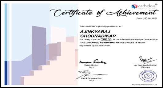
THE LUNCHBOX, ARCHDAIS ( OFFICE BUILDING AT BANGLORE , INDIA) (SHORTLISTED TOP 50)
THE DRAWING BOARD , ROHAN BUILDERS TROPHY ( KNOWLEDGE CENTER AT PUNE , INDIA)
ANDC, NASA INDIA ( REDEVLOPMENT OF RANJE VILLAGE , INDIA) (SHORTLISTED TOP 60)
LANDSCAPE TROPHY , NASA INDIA (CANALFRONT DEVELOPMENT AT PUNE , INDIA)
GRIHA TROPHY , NASA INDIA ( MIX USED HOUSING AT LUCKNOW , INDIA)
ANDC, NASA INDIA ( RECREATIONAL SPACE AT YERWADA PRISON , INDIA) (SHORTLISTED TOP 60)
HORRORS OF THE CITY , NASA INDIA (SCIENCE PARK) (1ST POSITION )
PARIVARTAN, TRAFFIC POLICE PUNE (TRAFFIC SOLUTION AT CONGRESS HOUSE ROAD) (1ST POSITION)
COLLEGE WORK COMPETITIONS
Bus stop (Parvati, Pune)
Healthcare Center (Kolhan, Raigad)
ACADEMICS
TOP 50 WORLDWIDE ARCHDAIS COMPETITION
COLLEGE SELECTION CONSTRO INDIA
1 ST POSITION IN ZONAL OVERALL TROPHY
1 ST POSITION IN PARIVARTAN TROPHY
EXTRA CURRICULAR
2 ND PLACE IN MAIDAN E JUNG (CRICKET TOURNAMENT AT PUNE)
1 ST PLACE IN SYMBOYSIS FASHION SHOW PUNE
EVENT HEAD OF KMATM (MODEL COMPETITION AT PUNE)
COLLEGE SELECTION FOR THE POST OF TREASURER
ANNUAL NASA CONVENTON, KERALA2018
ANNUAL NASA CONVENTON, BANGALORE 2019
ANNUAL NASA CONVENTON, BANGALORE 2020 DELINEATION
GRIHA WORKSHOP
SMART CITY
MANAGEMENT
Weekend House (Khadakwasla, Pune)
Daycare Center (Bhuj, Gujrat)
Art and Craft Center (Bhuj, Gujrat)
Higher secondary school (Panchgani)
Commercial Complex (Lucknow) Business hotel (Chandigarh)
Olympic museum (Mumbai) Rental housing (Hingewadi, Pune)
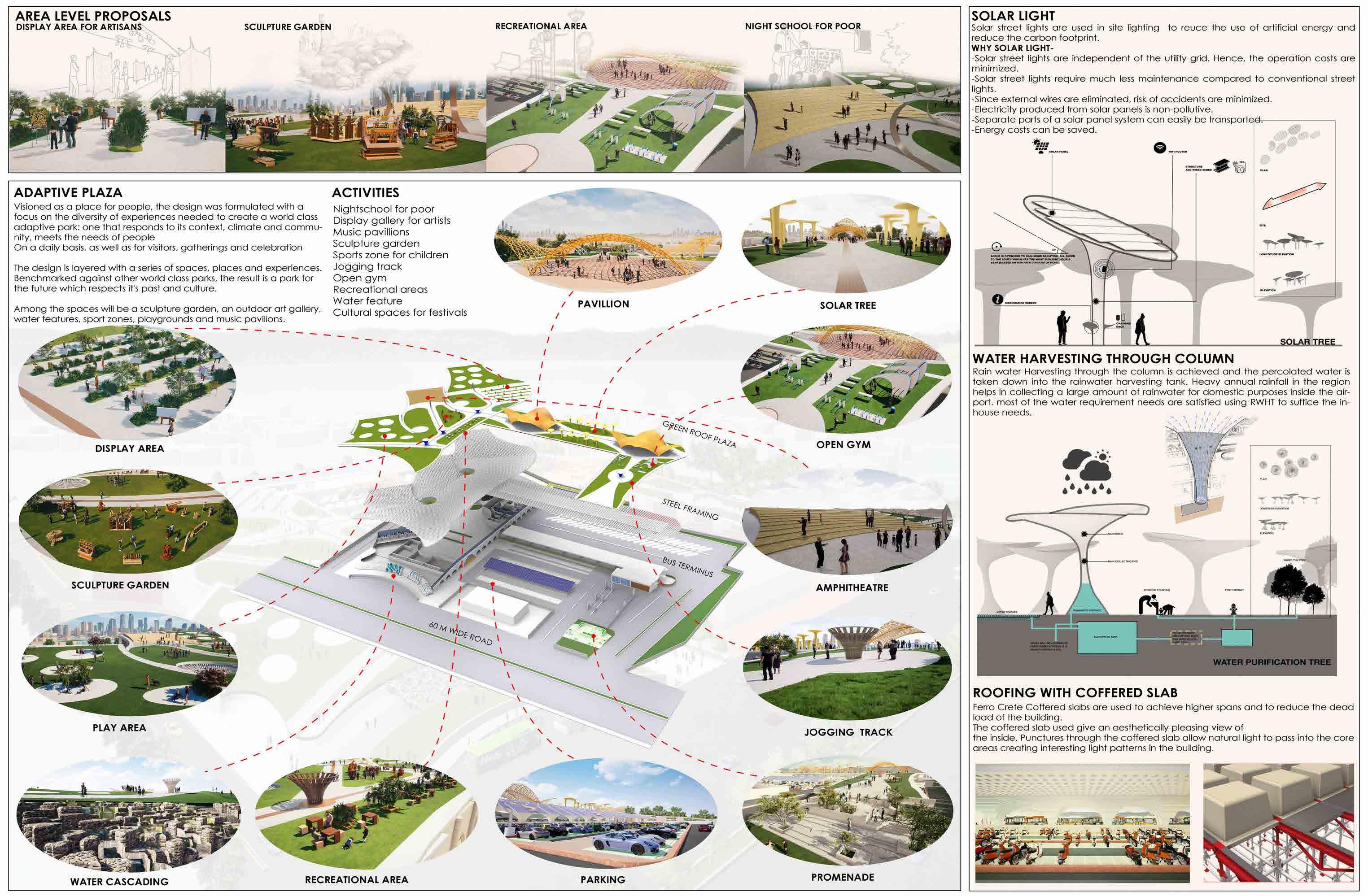
Landscape Trophy Science park, Pune Parivartan Trophy Traffic solution at manapa, Pune ANDC Trophy Recreational space at yerwada prison
HOTC Trophy Display area at temples, Pune
Griha Trophy Mix used housing at Lucknow
Landscape Trophy Canalfront development, Pune
ANDC Trophy
Redevelopment of ranje village, Pune Rohan Builders Trophy Knowledge center at Pune Archdais Lunchbox Trophy Office building at Banglore
Interstate Bus terminus (Katraj, Pune)
Gsen Trophy Hyperreal city, Antara
Griha Trophy New terminal building at Bagdogra
AUTOCAD SKETCHUP VRAY LUMION PODIUM PHOTOSHOP TWINMOTION KEYSHOT REVIT INDESIGN ILLUSTRATOR SKETCHBOOK
PUNE
DISASTER
EDUCATION WORK EXPERIENCE COMPETITIONS ACHIEVEMENTS WORKSHOPS 2018 2016 - 2021 2014 - 2016 2004 - 2014 2020 2019 2018 2020 2017 2018 2019 2016 2019
PROJECTS
01 NEW TERMINAL BUILDING FOR AIRPORT AT BAGDOGRA, INDIA 02 INLAND MULTIMODAL PORT, VARANASI INDIA 03 BUS TERMINUS AT KATRAJ, INDIA 04 OFFICE BUILDING AT BANGLORE, INDIA 05 KNOWLEDGE CENTER AT PUNE, INDIA 06 RENTAL HOUSING AT HINGEWADI, INDIA 07 HIGHER SECONDARY SCHOOL AT PANCHGANI, INDIA 08 COMMERCIAL BUILDING AT LUCKNOW, INDIA 09 REDEVELOPMENT OF RANJE VILLAGE, INDIA 10 HYPERREAL CITY - ANTARA TABLE OF CONTENTS TREE HOUSE
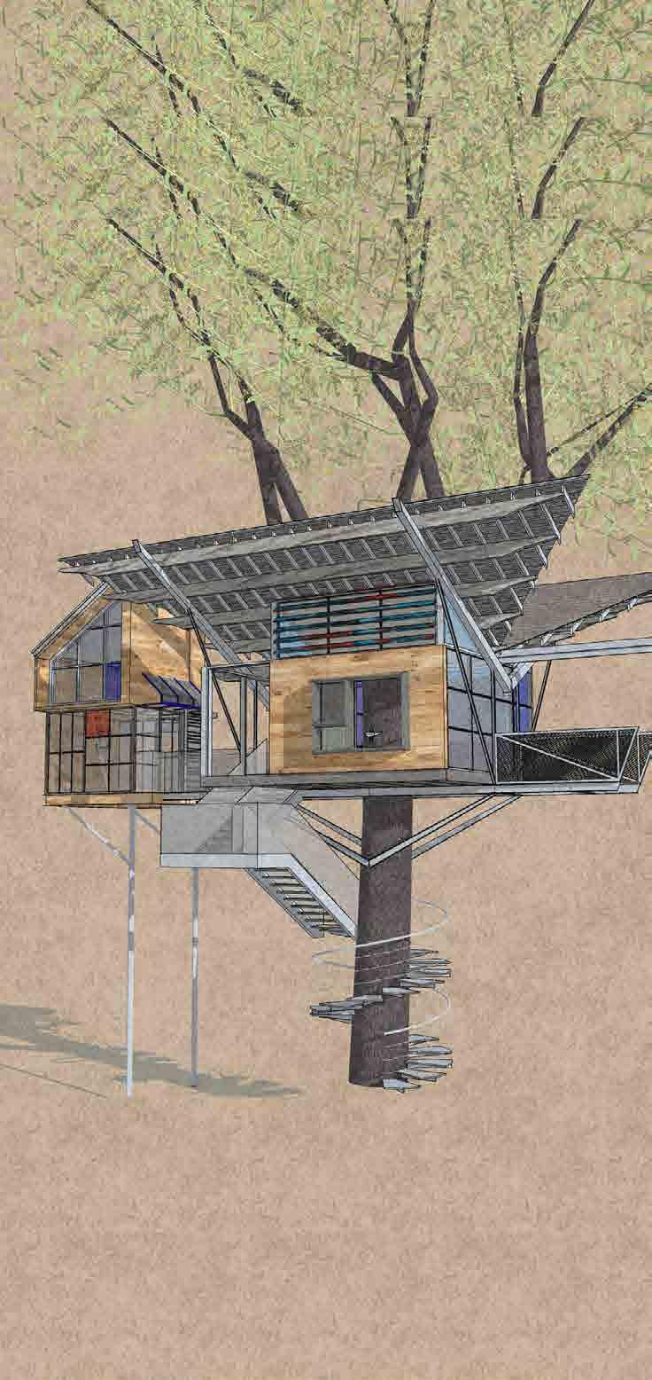
PUNE
AT KHADAKWASLA
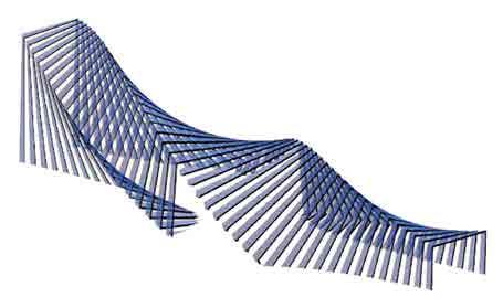
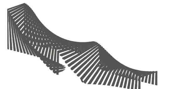
THE CROWN REFRAMING OF PAGODAS
Project Category : Public Transport Project Year : 2021
Role : Conception, Plans, 3D visualisation
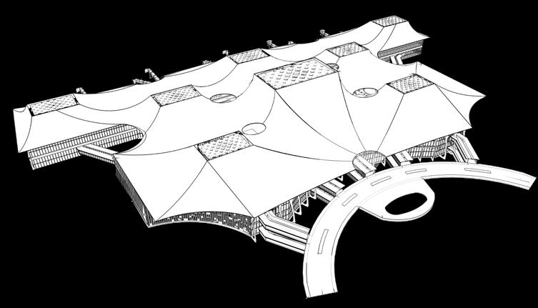
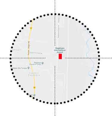
Location : Bagdogra, India

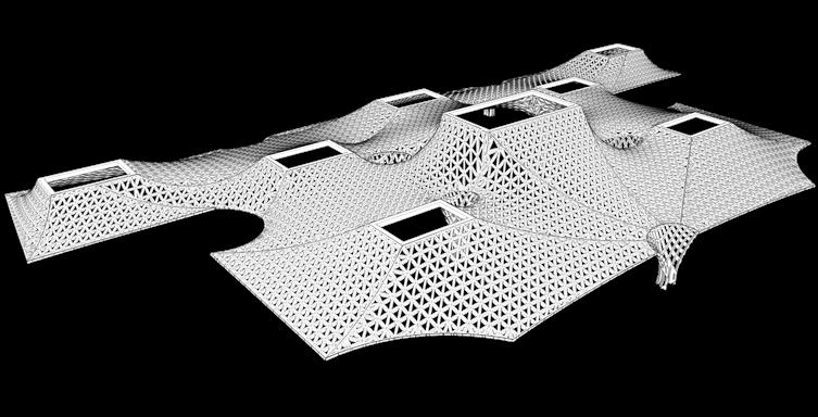
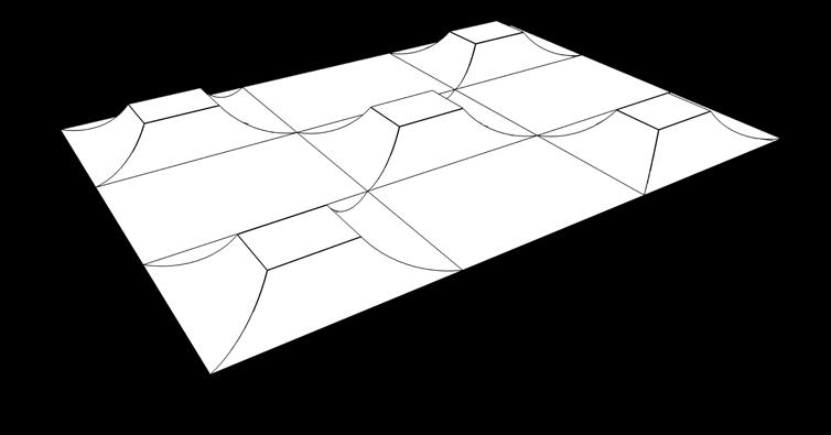
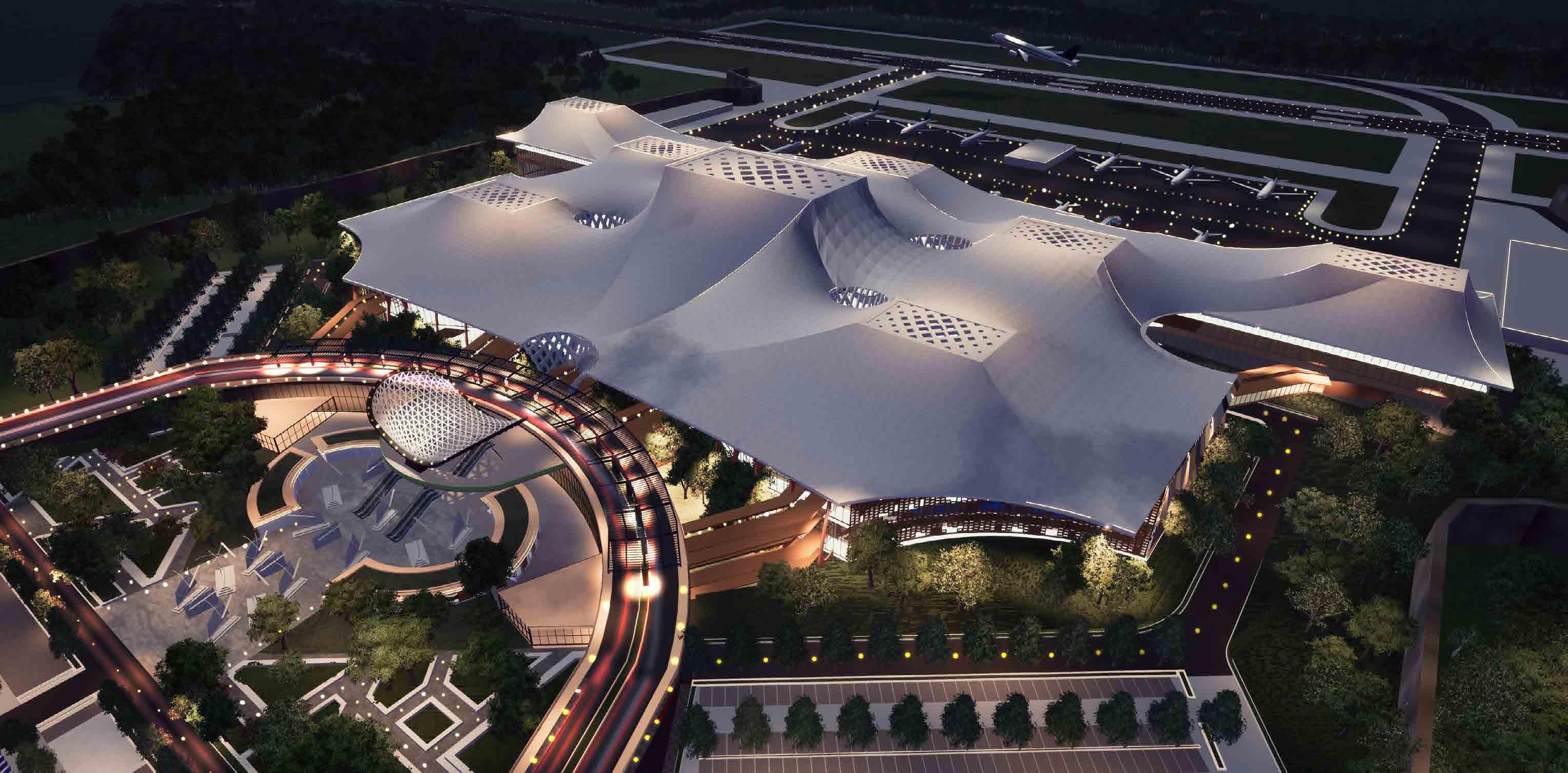
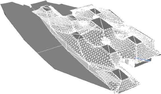
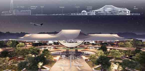
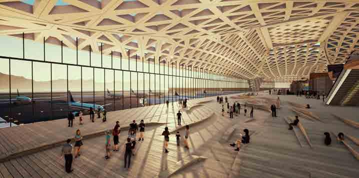
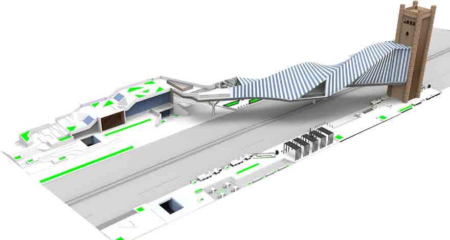
A magnificient structure that depicts the grandeur of the space and an experience of rich culture and heritage. A classic fusion of the old and the new, combining legacy with modern ideas, elevating the standards of infrastructure in the region. Nestled in the valleys of the Himalayan foothills and surrounded by the lush fields of tea plantations, the proposed airport sits in one of the strategically important locations of the region that connects the east valley with the rest of India and the Bhutan-Nepal-Bangladesh tri-section. The design for the airport at Bagdogra is a clear reflection of the spirit, heritage and culture of region. Inspired by the traditional pagodas of Buddhist architecture coupled with high end technological systems to achieve a sustainable and environment friendly structure.
Final Form
Typical Pagoda Abstraction of Pagoda Curve defining Modernity
SITE ZONING
Area : 95000 Sq.m

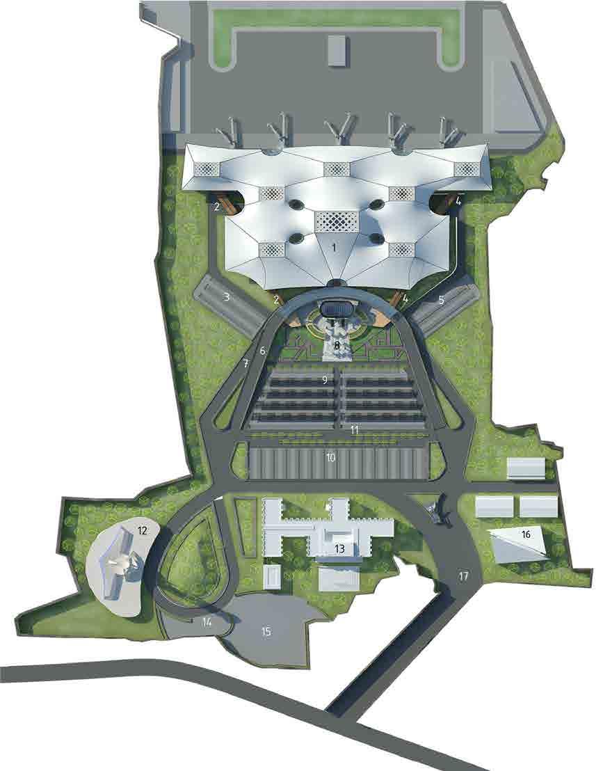
Passenger Capacity : 3800 PHP
North south orientation is maintained to have maximum advantage of the solar orientation. 36m wide main road which is divided into 2 subroads connecting departure level at upper level and arrival level at lower level entry and exit for staff and vip is separate. Entry and exit for normal passengers is separated by levels to clearly segregate the incoming as well as out going passengers. Service blocks are placed strategically with the wind direction. Easy movement for service vehicles. Clear access for emergency vehicles. A 17000 sq.M (1300 cars) parking for passengers and transit hire vehicles is planned for smooth circulation. A.T.C tower (90 m tall) is strategically located to have a clear view of the run way and air strip. A hotel and commercial block is provided at a convinient loaction of the airport building.
SITE PLAN
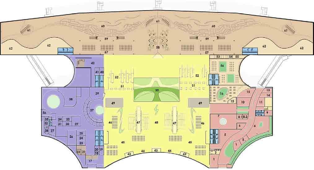
Legends 1. New terminal building 2. Staff entry 3. Staff parking 4. Vip/cip parking 5. Vip/cip parking 6. Road to departure 7. Road to arrival 8. Plaza and foodcourt 9. Cab parking 10. Visitors parking 11. Bus stop 12. Atc tower 13.Commercial complex 14. Parking for atc tower 15. Commercial complex Parking 16. Site services block 17. Entry/ exit GEOGRAPHICAL LOCATION SUN PATH AND WIND ANALYSIS SHADOW ANALYSIS 9 AM 12 PM 3 PM
DESIGN CONSIDERATIONS

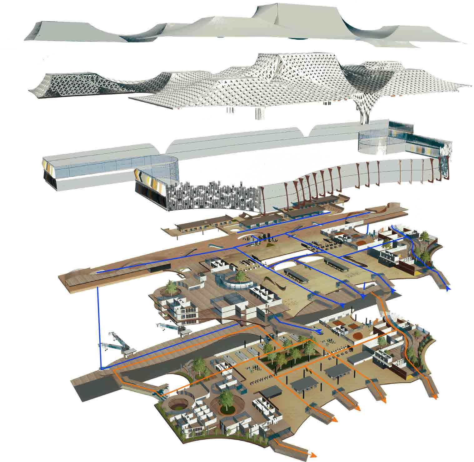
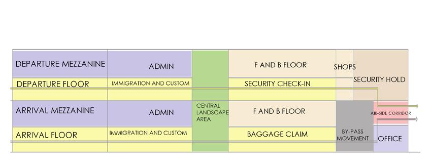
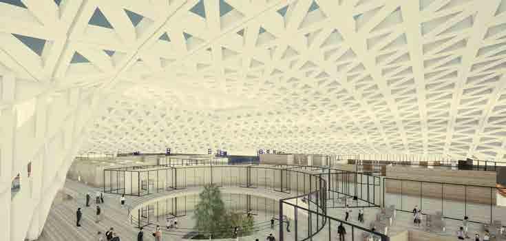
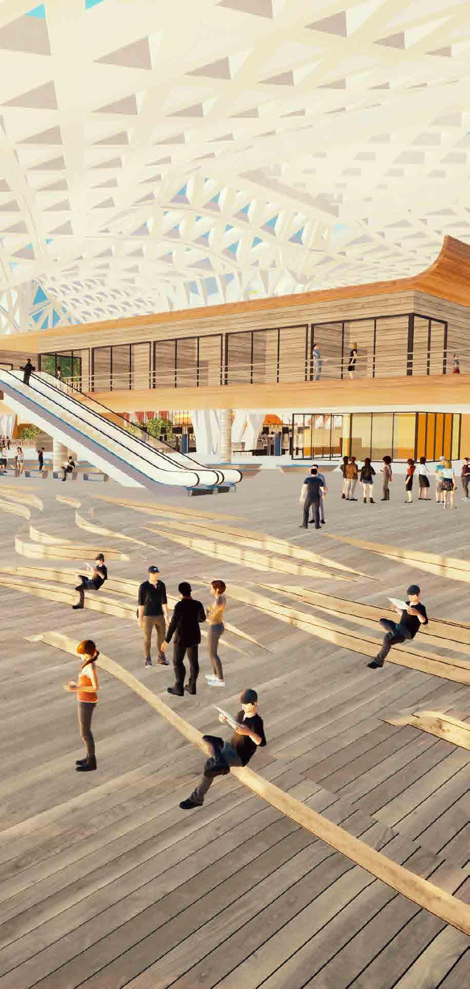
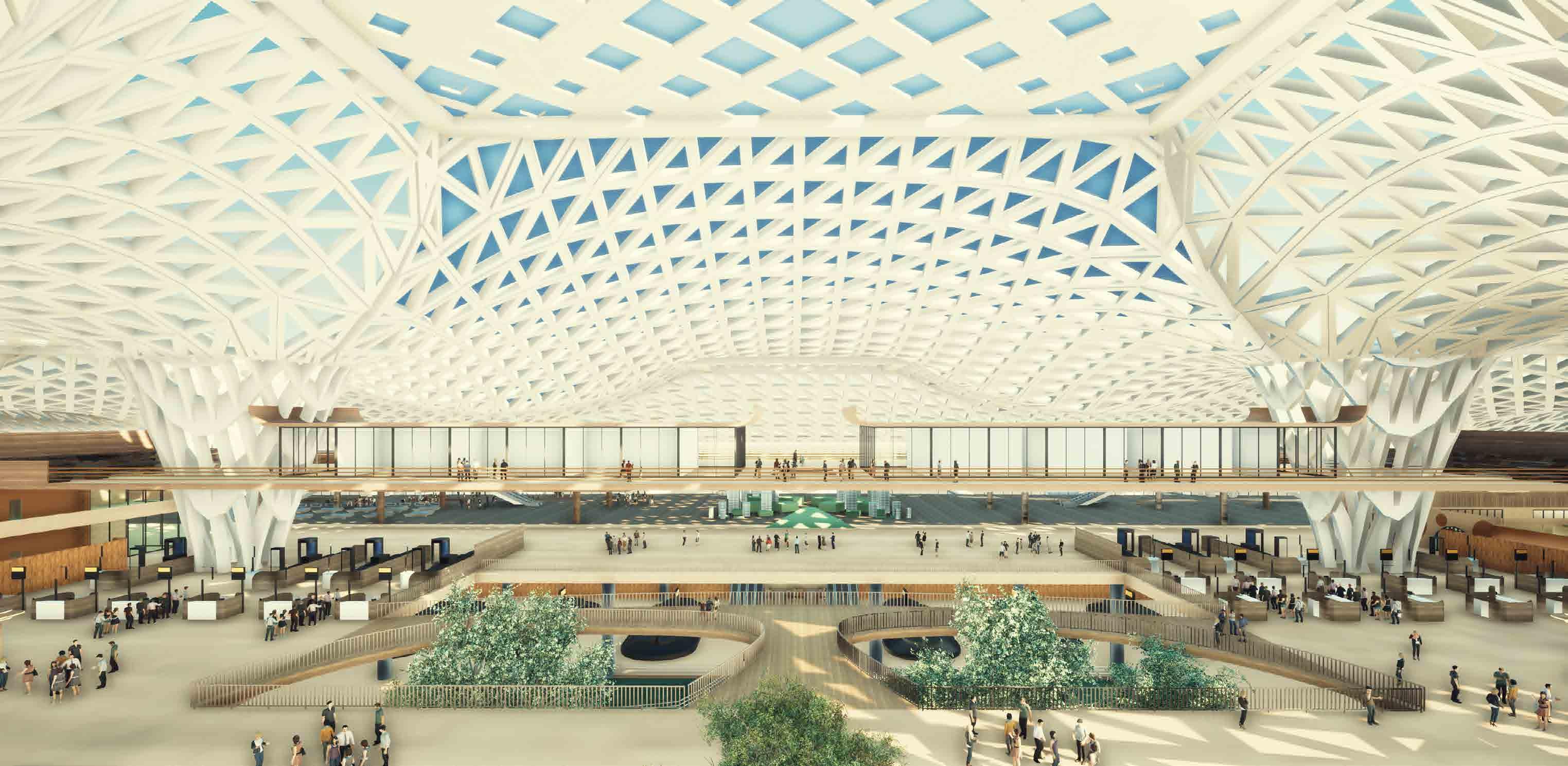
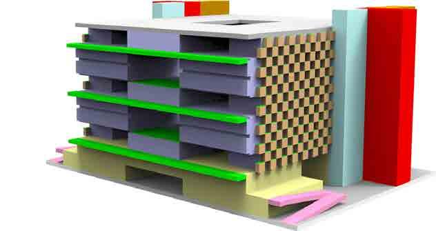
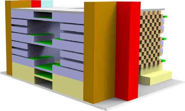
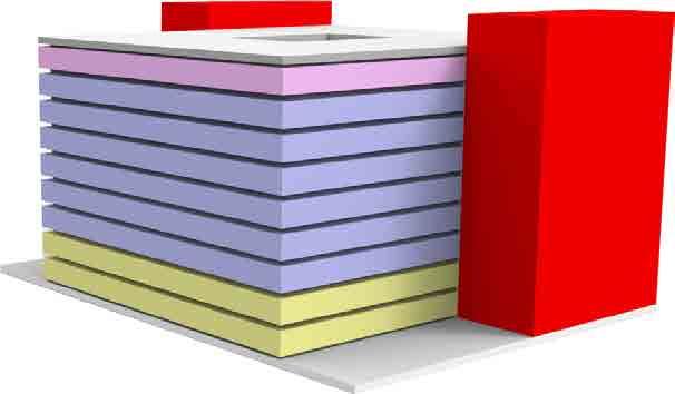
Spatial Planning - Vertical : Spatial planning for the building is a simple 4 levels plan viz the basement , ground level, first level and the mezzanine. Basement – Service zones and staff parking Ground level – Arrival First level – Departure Mezzanine – Retail and F&B The total gross area of the building comes out to be 97000 sq.m Horizontal: Central core area plays a major role as it connects all the levels. A transit bridge provided on departure level helps passengers get the feel of the valley with the indoor landscape provided below in the core central area.
The admin areas are provided with indoor vegetation to boost their productivity and enhance their work environment.
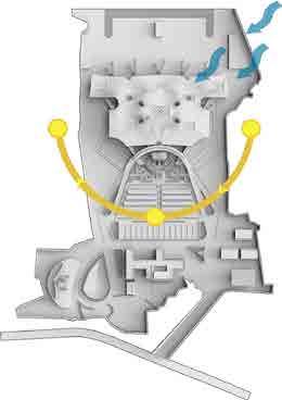
Access - Site can be accessed through various forms of transportation-both private and public. Departure level is connected with an access bridge for easy movement of vehicles in and out of the site.
Light and ventilation - Natural Light ventilation is put to maximum advantage with clear openings on the northern and southern facade. Since the climate of the site is of semi-tropical type, Hybrid HVAC system is used to maintain the high humid conditions at comfortable levels.
Circulation - Simple and hassle free circulation path is provided from the entry point to the plane boarding station enabling a passenger to board a flight with 20 minutes of arrival to the airport. Similar circulation is designed for the departure. A mezzanine floor is provided for easy circulation which connected to both the arrival as well as departure levels.
Climate Sustainability- Design sustainability is practiced by inducing passive design strategies and environment friendly elements. Passive design systems :
•Use of orientation to max advantage.
•Maintaining proper ventilation.
•Smart fenestration design and orientation / positioning.
•Efficient lighting design etc.
•Consuming less energy
EVOLUTION OF PLAN
1)A.A.I. OFFICE
2)STAIRCASE BLOCK
3)A.H.U.
4)V.I.P. WAITING ROOM
5)CONFERENCE ROOM
6)ARTICALS
7)V.I.P. CEREMONIAL HALL
8.1)STORE
8.2)HEALTH COUNTER
9)CCTV/ CONTROL ROOM
10)CUSTOMS OFFICE
11)ARRIVAL HALL
12)SECURITY OFFICE
13)REST ROOM
14)IMMIGRATION ROOM
15)KITCHEN
16)RESTAURANT 17)A.A.I. OFFICE
18)LADIES CHANGING ROOM
19)TROLLY AND WHEEL CHAIR STORE
20)GENTS CHANGING ROOM
21)CONTROL ROOM
22)A.A.I.OFFICE
23)CIVIL MAINTAINANCE DEPT
24)CUSTOMS OFFICE
25)DETENTATION ROOM
26)CUSTOMS BONDED STORE
27)ELECTRICAL / MECHANICAL MEINTAINANCE WORKSHOP 28)A.H.U.
29)CUSTOMS WARE HOUSE 30)STORE
31)SEARCH ROOM
32)REST ROOM
1)A.A.I. OFFICE
2)STAIRCASE BLOCK 3)A.H.U.
4)V.I.P. WAITING ROOM
5)CONFERENCE ROOM
6)ARTICALS
7)V.I.P. CEREMONIAL HALL 8.1)STORE
8.2)HEALTH COUNTER
9)CCTV/ CONTROL ROOM
10)CUSTOMS OFFICE
11)ARRIVAL HALL
12)SECURITY OFFICE
13)REST ROOM
14)IMMIGRATION ROOM
15)EXIT FOYER
16)PUBLIC ARRIVAL HALL

17)CONTROL ROOM
18)LADIES CHANGING ROOM
19)GENTS CHANGING ROOM
20)LOST BAGGAGE
21)TROLLY AND WHEEL CHAIR STORE
22)A.A.I.OFFICE
23)CIVIL MAINTAINANCE DEPT 24)CUSTOMS OFFICE 25)REST ROOM
26)A.H.U. 27)ELECTRICAL / MECHANICAL MEINTAINANCE WORKSHOP
28)CUSTOMS BONDED STORE 29)CUSTOMS WARE HOUSE 30)STORE
31)SEARCH ROOM
32)DETENTATION ROOM
33)SECURITY OFFICE
34)HEALTH OFFICE
35)MISHANDLED BAGGAGE ROOM 36)APRON CONTROL ROOM 37)AIRLINE COUNTERS AND BACKUP OFFICES 38)STAFF CANTEEN 39)DUTY FREE SHOP 40)IMMIGRATION ROOM 41)EQUIPMENT ROOM
42)STAIRCASE LOBBY AND DRINKING WATER
43)ENTRANCE FOYER
44)TICKET COUNTER
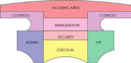
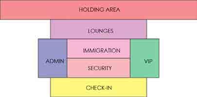
45)DEPARTURE CONCOURSE
46)DEPARTURE WAITING AREA 47)AIRLINE CHECK-IN COUNTERS
48)CENTRAL LOBBY 49)RETAIL SHOPS
50)BRIDGE
51)IMMIGRATION AND CUSTOM COUNTERS 52)SECURITY CHECK AREA WITH FRISKING GATES 53)FOOD COUNTERS 54)LACTATION ROOM 55)SMOKING ROOM 56)FOOD ZONE
57)DEPARTURE/TRANSIT LOUNGE 58)CULTURAL DISPALY AREA 59)ESCALATOR TO MEZZANINE 60)SECURITY HOLD AREA 61)ESCALATOR TO AIR BRIDGE 62)LOUNGES
33)SECURITY OFFICE 34)HEALTH OFFICE 35)MISHANDLED BAGGAGE ROOM 36)APRON CONTROL ROOM 37)SHOP 38)DUTY FREE SHOP 39)STRONG ROOM 40)HEALTH ROOM 41)IMMIGRATION ROOM 42)EQUIPMENT ROOM 43)RETAIL SHOPS 44)OFFICE 45)MONEY EXCHANGE COUNTER 46)IMMIGRATION COUNTER 47)CUSTOM COUNTER (DOMESTIC AND INTERNATIONAL) RED CHANNEL GREEN CHANNEL 48)LANDSCAPE 49)WALKWAY 50)CUTURAL DISPLAY AREA 51)BAGGAGE CLAIM AREA 52)FOOD COUNTERS 53)LACTATION ROOM 54)FACILITIES MAINTAINANCE 55)SMOKING ROOM 56)FOOD ZONE 57)RESTAURANT 58)KITCHEN 59)BUS LOUNGE 60)POSTAL SORTING 61)OFFICE 62)MECHANICAL EQUIPMENT ROOM 63)STORE 64)ELECTRICAL EQUIPMENT ROOM
CIRCULATION IN SECTION
SECTION
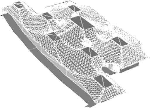
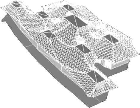
EXPLODED VIEW
Arrival Movement Departure Movement
GROUND FLOOR LEVEL PLAN ARRIVAL LEVEL LVL
FOOD AND BEVERAGES LEVEL PLAN LVL 21M) FIRST FLOOR LEVEL PLAN DEPARTURE LEVEL
2.1M)
LVL 12.1M)
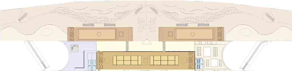
View of Air side View of South Facade View of East West Facade
View of Concourse Area
View of Admin Block
of Waiting Area at Departure Level
View
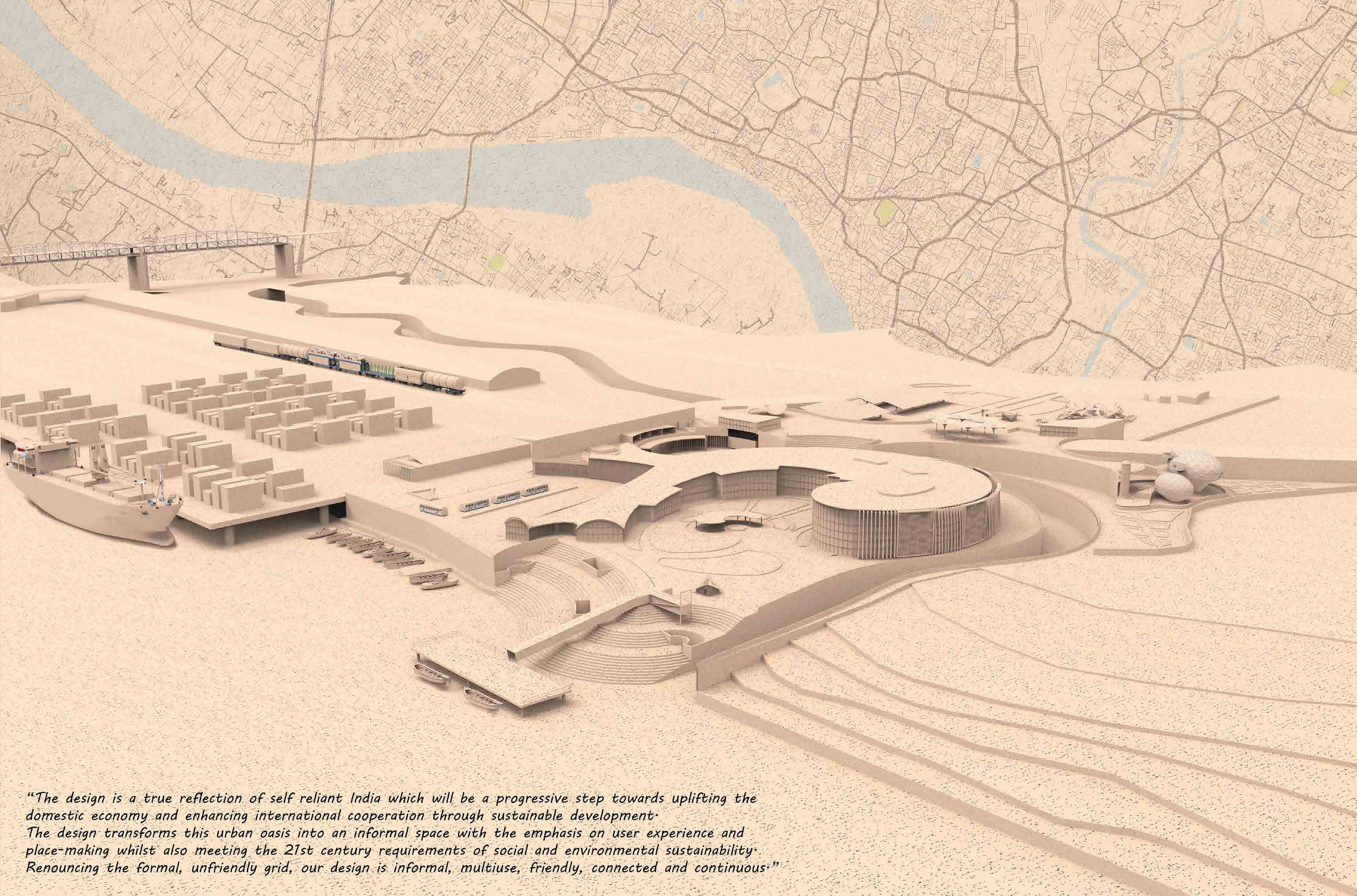
INLAND MULTIMODAL
PORT, VARANASI
Project Category : Public Transport Project Year : 2021
Role : Conception, Plans, 3D visualisation
Location : Varanasi , India
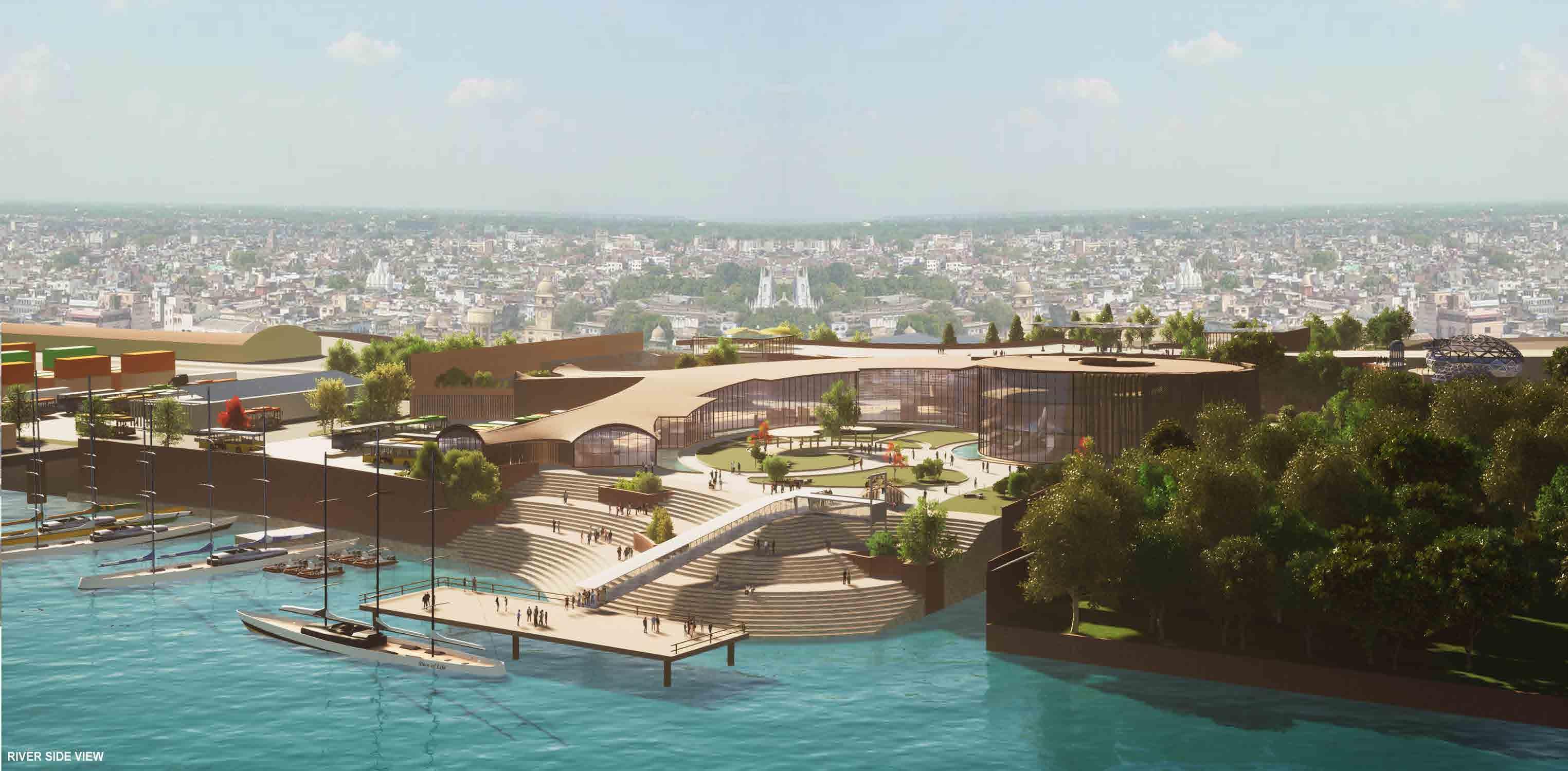
The urgent need of waterway transport and infrastructural development for boosting the domestic economy under the Atmanirbhar Bharat scheme and also the rapid evolution in Varanasi and urban expansion inspired me to design a such Inland Multimodal Transit Hub (Multimodal connectivity project) especially focusing on city’s economic growth with eradicating the issues of unemployment, poverty and issues related to logistic sectors and exports industries. This thesis proposes the design of Inland Multimodal Transit Hub for use in transport, entertain and landmark applications in remote locations. The thesis proposes a terminal that is gateway, special and unique.
The main aim of the project is to show urban evolution. It does not become a station for transportation only, it also include a public spaces, pedestrian walkway and open spaces to accommodate people with nature and socialize them. The space inside responsible of being dynamic, calming and functional. The space can create a life different from their own. The inland multimodal transit hub will focus not only on the transport of goods, ferry services as the mode for public transportation but also envisions a holistic developments of the areas being connected by waterways by integrating the waterway system with the other public transport of the city. The multimodal transit hub should be an initiative to boost domestic economy under the Jal Marg Vikas Project (JMVP) scheme.
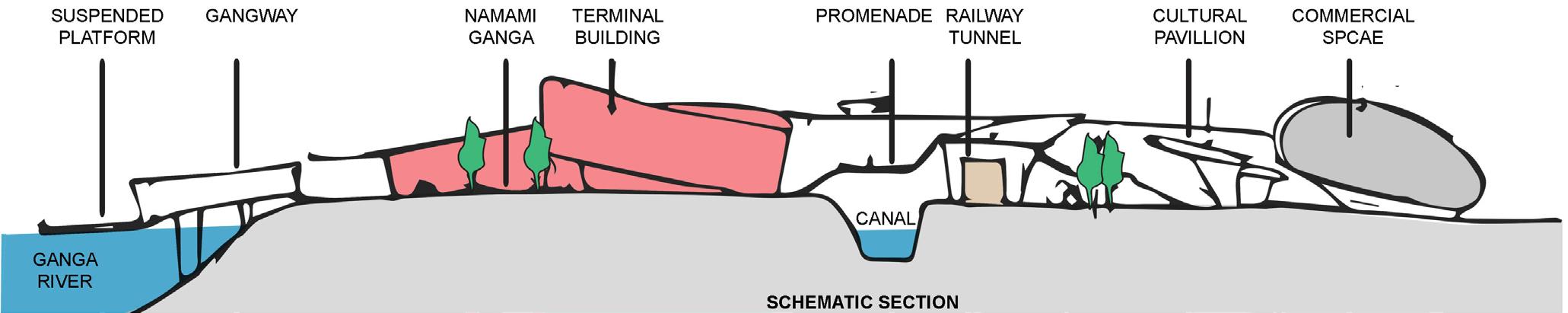
There is a global practice of representing national symbol in a nationally important structure either in form or in concept which shows cultural, societal aspects of that particular country. As this is the first inland waterway multimodal transit hub in India, the terminal building’s form is inspired from Ganges River Dolphin which is the National Aquatic Animal of India. It is one of the National Symbols of India. Ganges Dolphin is seen as the reflector of the health of the Ganga River.
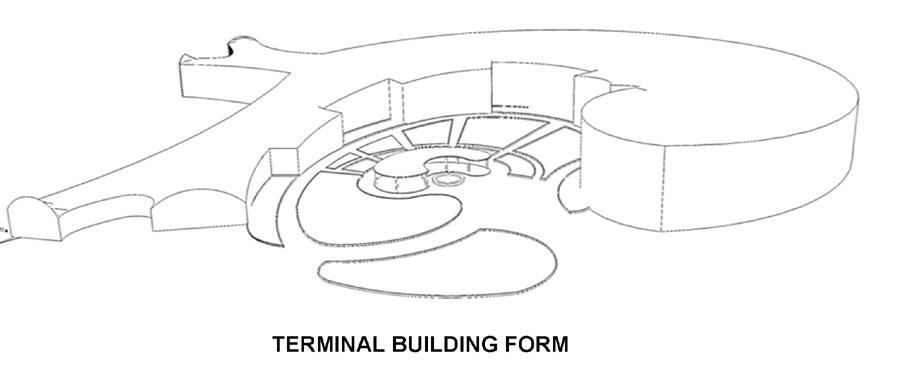
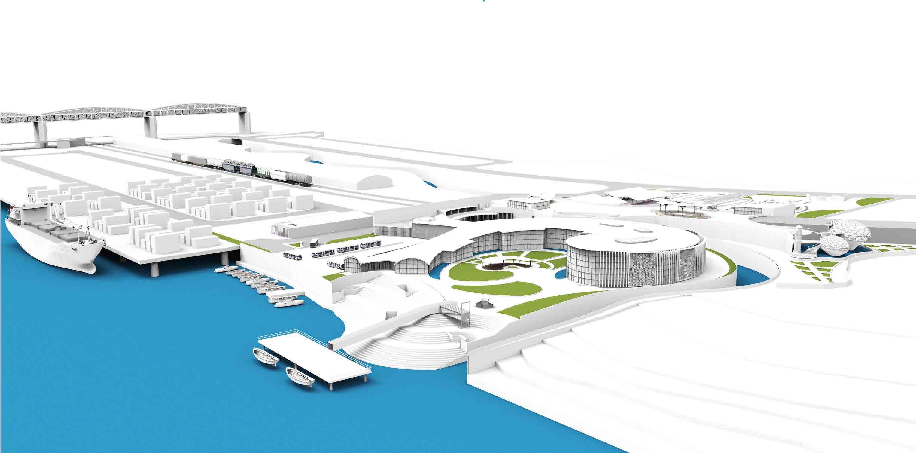
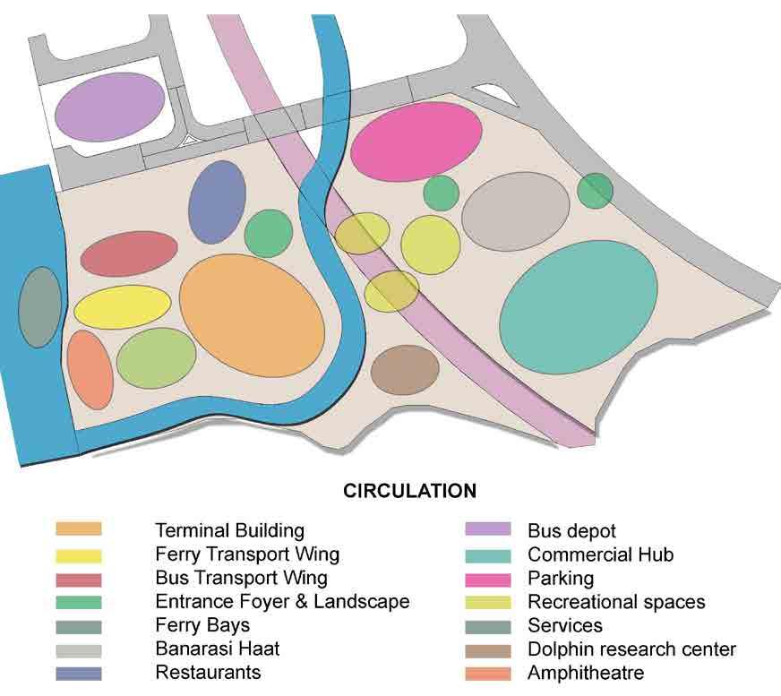
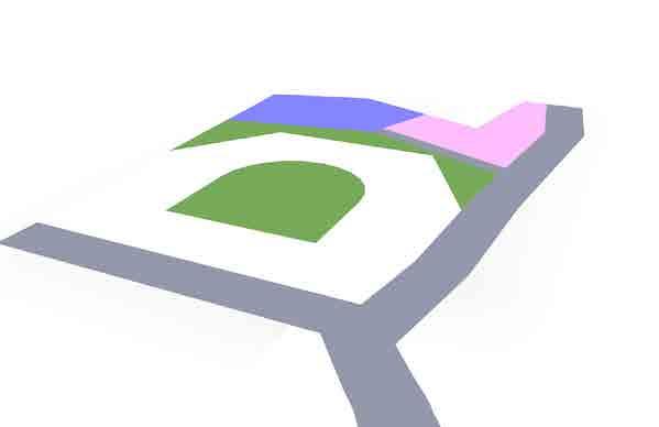
ZONING

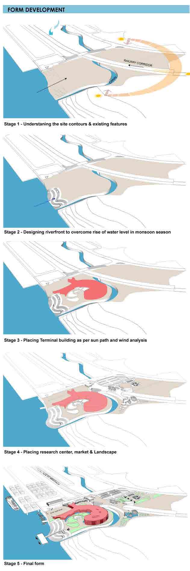
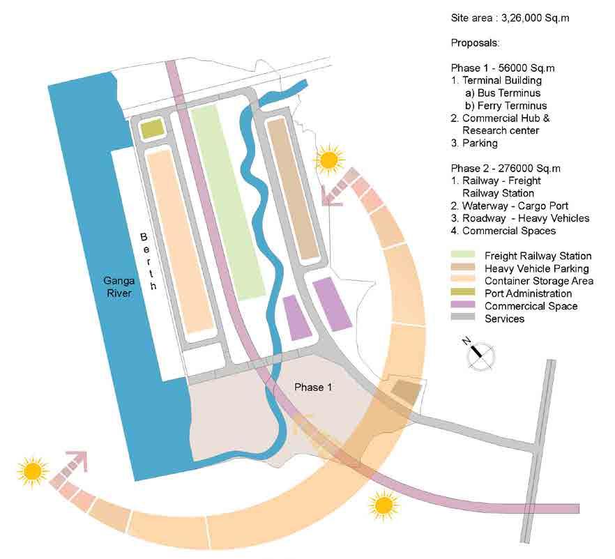
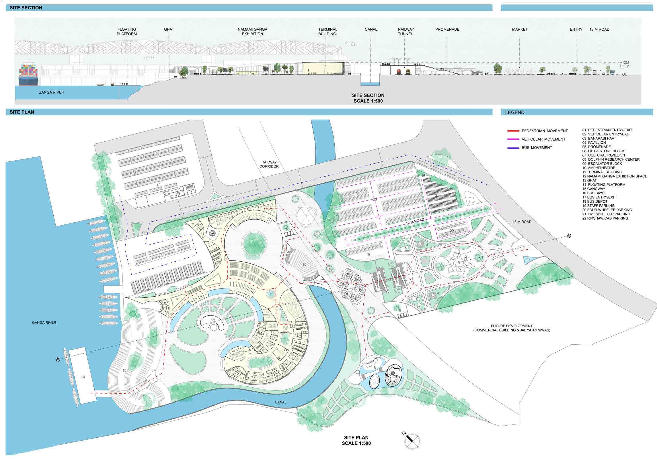
MASTER PLAN
BANARASI HAAT
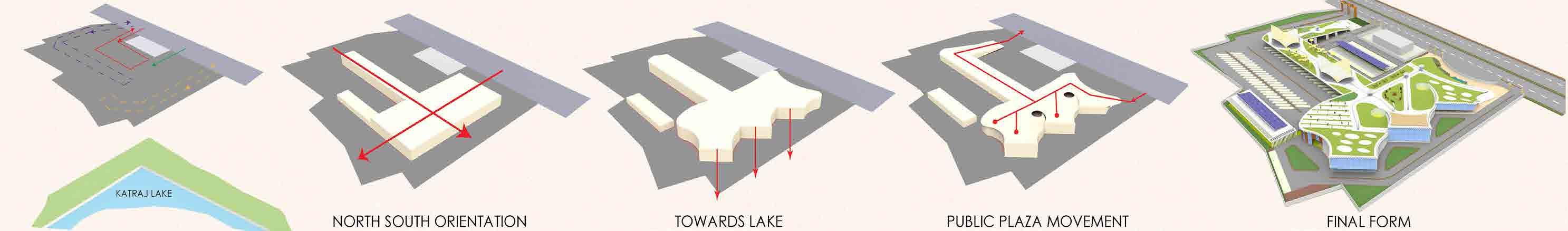
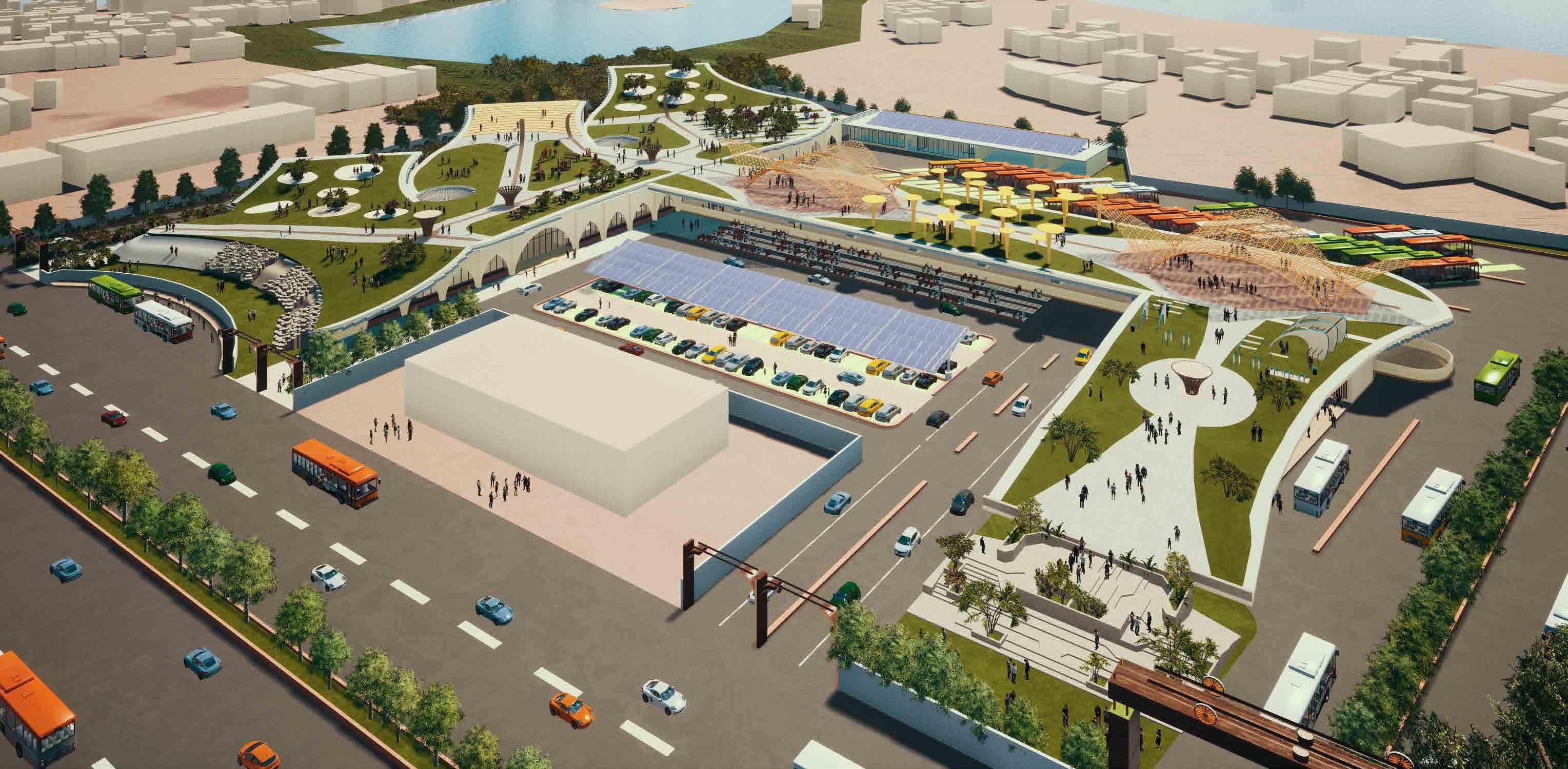
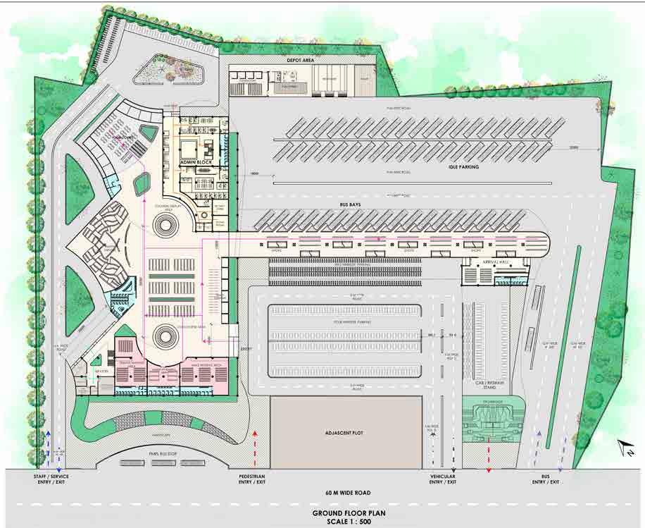
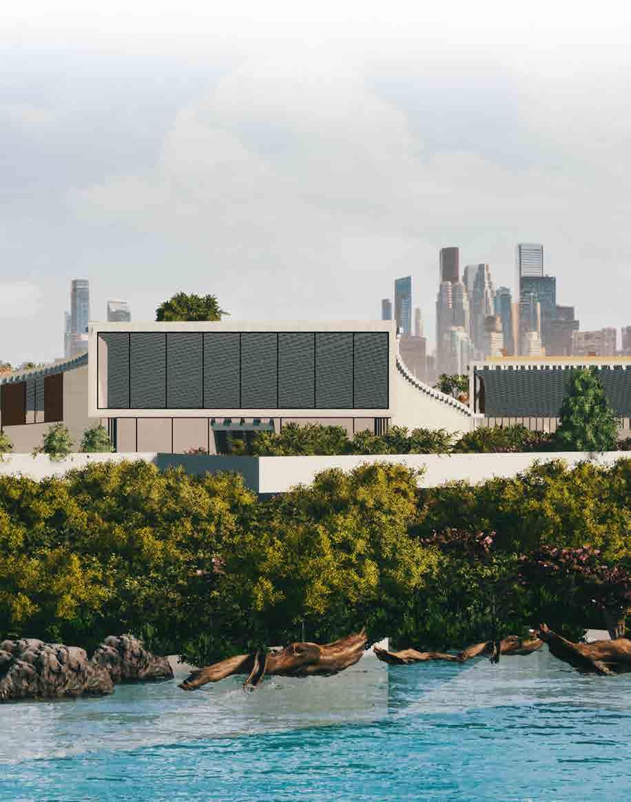
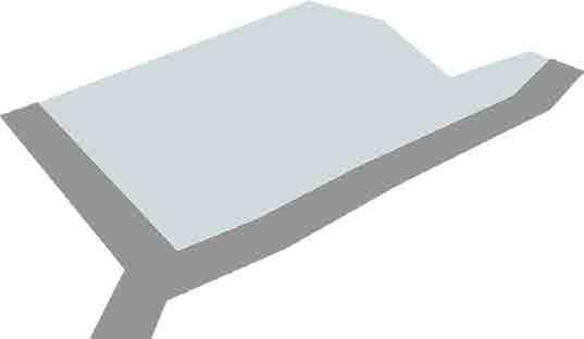
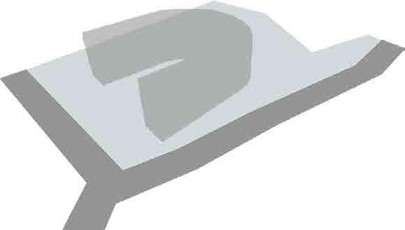
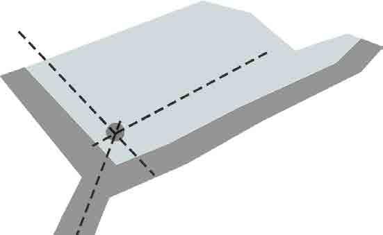
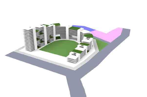
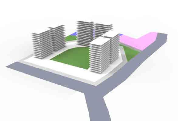
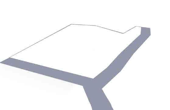
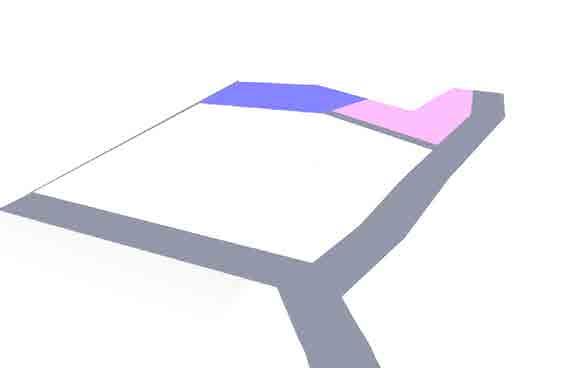
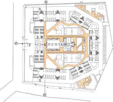
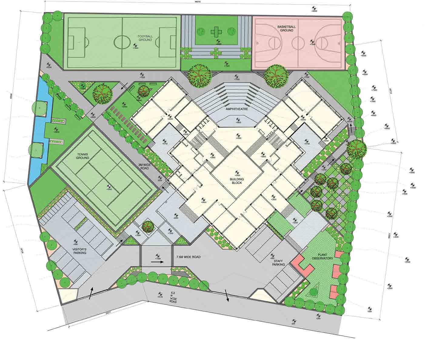
BUS TERMINAL KATRAJ, PUNE
Project Category : Public Transport
Project Year : 2020
Role : Conception, Plans, 3D visualisation
Location : Pune, India
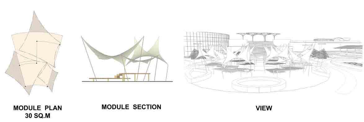
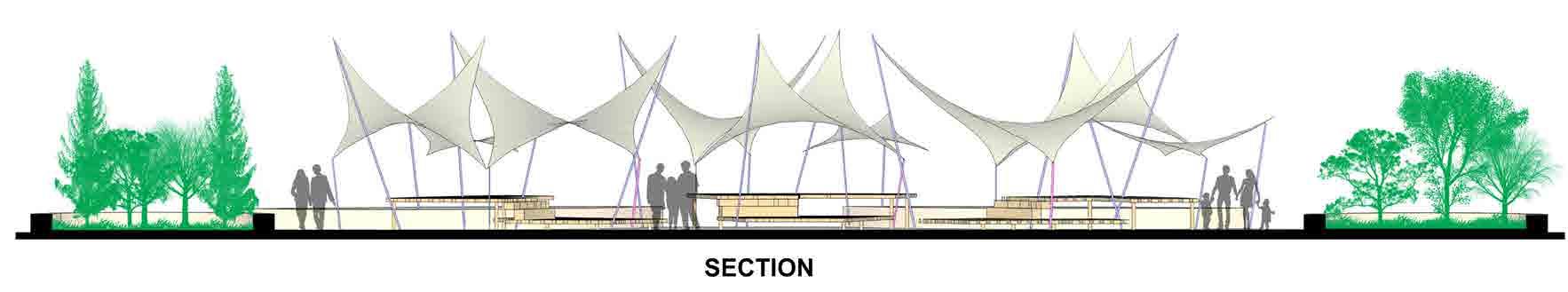
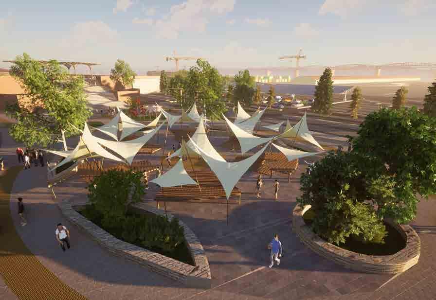
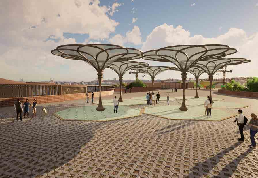
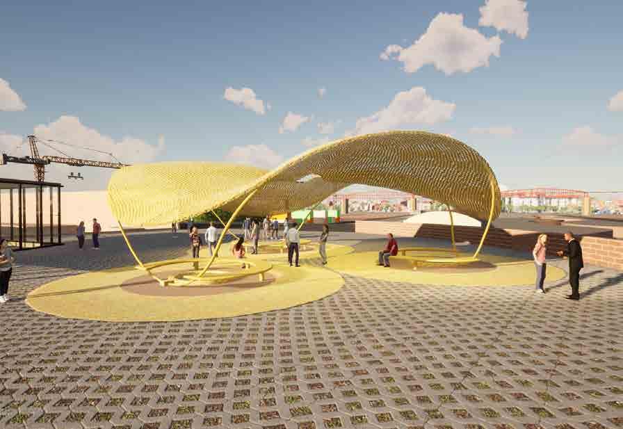
Bus terminal building is located on a 11 acre site which has a lake on the northen side and road towards western side. The design has a very special connect with the site and the adjoining lake. The idea is of exploiting every view possible to the lakeside makes any user a spectator of this serene setting Building is oriented with longer sides facing north – south to bring in glare free natural light. Porosity in planning and form allows continuous movement of breeze with wind tunnels creating venturi effect.
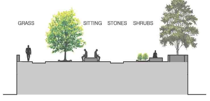
Visioned as a place for people, the design was formulated with a focus on the diversity of experiences needed to create a world class adaptive park: one that responds to its context, climate and community, meets the needs of people on a daily basis, as well as for visitors, gatherings and celebration. The design is layered with a series of spaces, places and experiences. Benchmarked against other world class parks, the result is a park for the future which respects it’s past and culture. Among the spaces will be a sculpture garden, an outdoor art gallery, water features, sport zones, playgrounds and music pavilions.
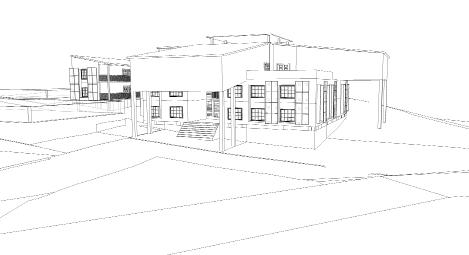
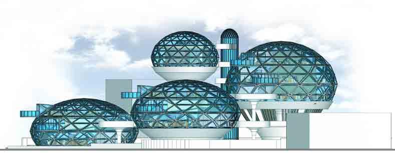
THE WORK GLOBULE
Project Category : Office Building
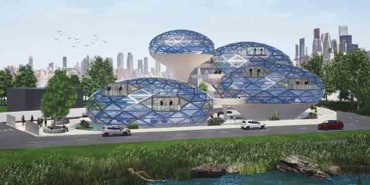
Project Year : 2019
Role : Conception, Plans, 3D visualisation


Location : Bangalore, India
The main motive of this brief is to design for this generation of entrepreneurs and their aspirations. The competition aims to design a small scale collaborative start-up business office for young entrepreneurs in the IT sector.
India’s entrepreneurial ecosystem is in a nascent stage and has given our young startups a hope to showcase their innovative talent and entrepreneurial skills with their undertakings in the corporate world. To support these budding talents, a cohesive and a well integrated working environment is a must for these ideas to blossom into successful enterprises. A well balanced work-live-recreate setting helps these entrepreneurs to produce and create inspiring work, recreate and energise their body and mind and live in a healthy environment.
Drop in the ocean is a perfect analogy for a young entrepreneur in the chaotic and crowded corporate setting. Its those small droplets that make up an entire ocean which in this analogy refers to the successful entrepreneurs that have build the present ecosystem for the young entrepreneurs.This concept is a major component that dictates the design and form of the project. The form is derived from the physical characteristics of a droplet before merging into a pool of water (the crowd of successful Entrepreneurs).
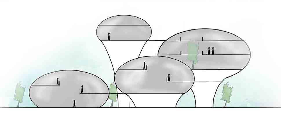
Water Droplet

Abstract of Water Droplet Conceptual Sketch Stages of Water Droplets

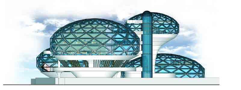
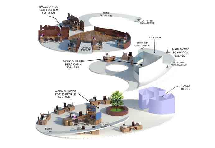
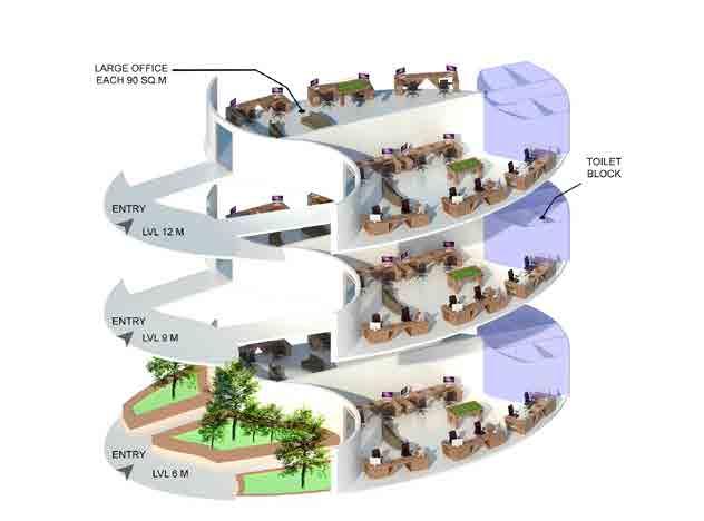
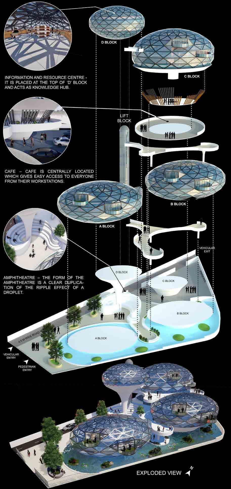

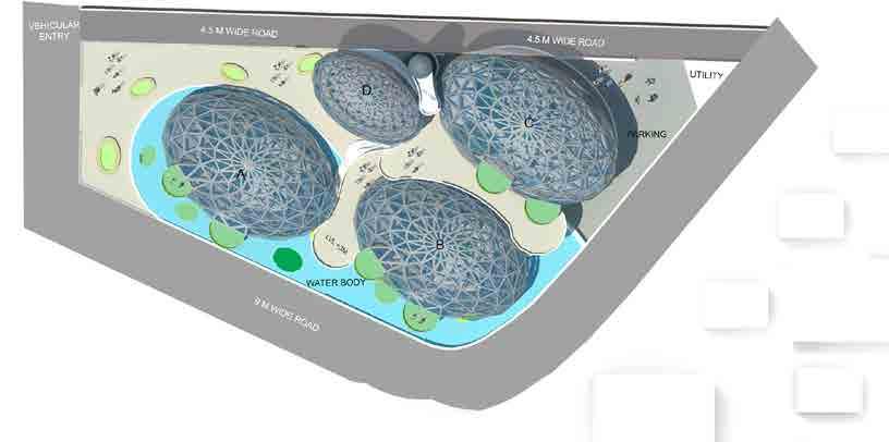
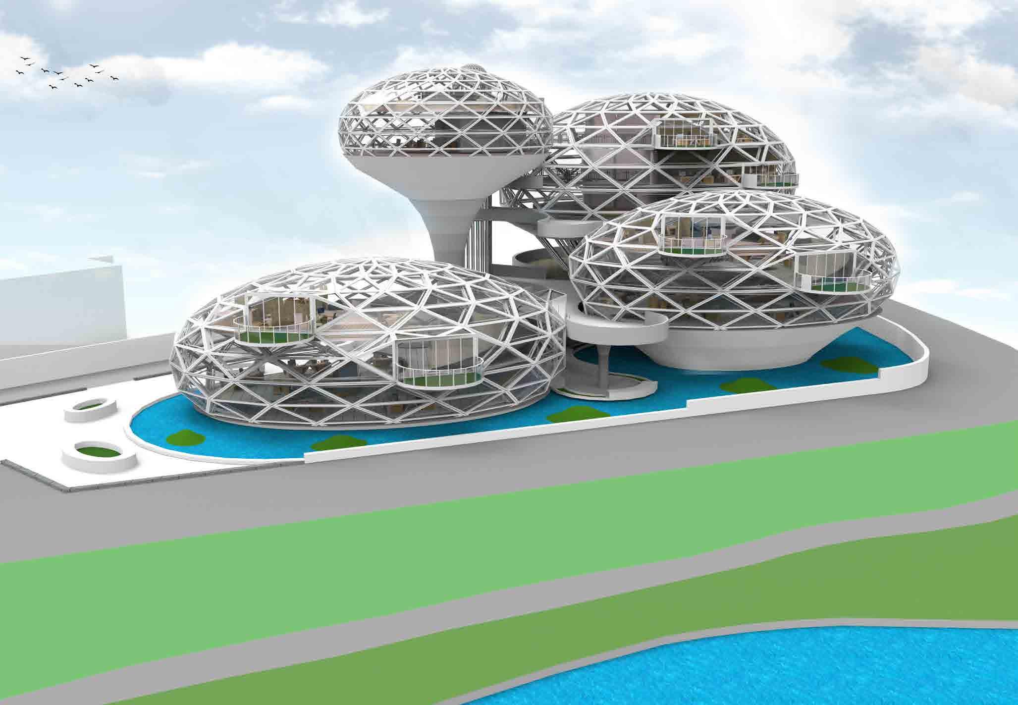
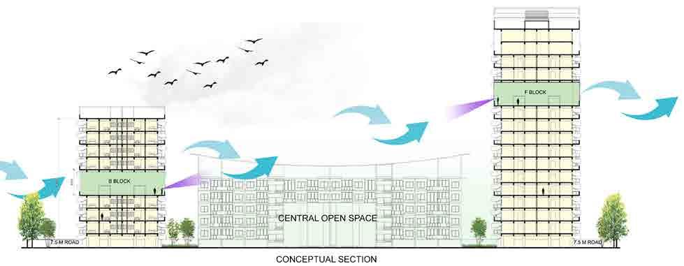
Typical C Block Typical A & B Block Conceptual Section EAST SIDE ELEVATION SITE PLAN NORTH SIDE ELEVATION Typical D Block A BLOCK (WORK CttLUSTER + SMALL OFFICE ) 280 SQ.M B BLOCK (WORK CLUSTER + SMALL OFFICE ) 280 SQ.M C BLOCK (LARGE OFFICE + LIBRARY ) 880 SQ.M D BLOCK (INFORMATION AND RESOURCE ) 180 SQ.M C Block (Large offices) B Block (Work clusters and small offices)
Lake view park A Block (Work clusters and small offices) 9 m Road D Block (Information and resource center) Lift and Staircase Block
Sheelavanthakere Lake
Rivaayat
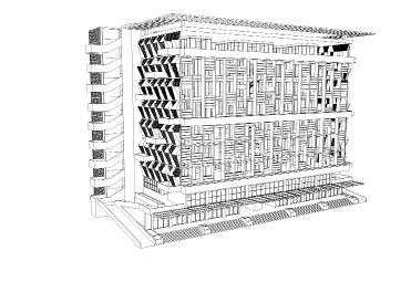
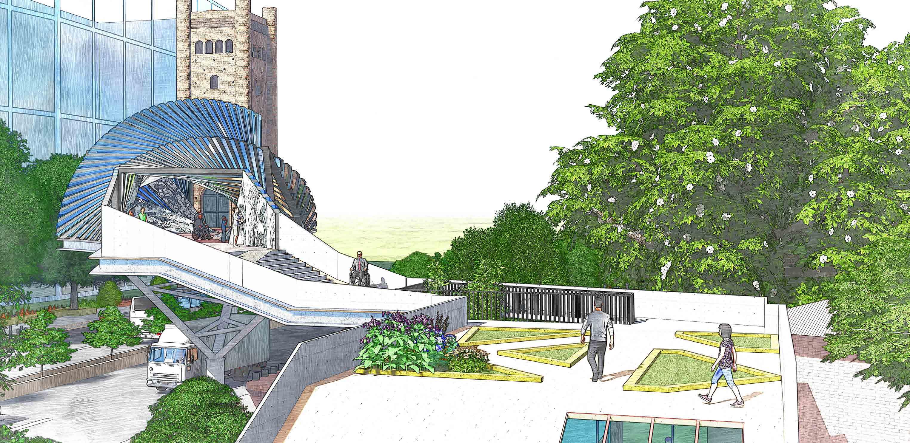
BYGONE & MODERN
Project Category : Knowledge Center
Project Year : 2019
Role : Conception, Plans, 3D visualisation
Location : Pune, India
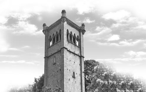
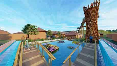
The brief aims to create a dialogue between the surrounding urban communities, citizens and 140 year old heritage water tower which is highly visible yet an isolated segment in urban fabric.
What is heritage but a treasure passed down to us by our ancestors.
Structures like these should be treasured, celebrated, instead of being labelled heritage. It is imperative that we understand the fact that mere maintenance and repair does not conserve the soul of building. These structures demand attention as they are wonders of their time and as designers, it is our duty to design structures such as to highlight them and increase their social value. With the help of modern materials and techniques we can conserve them and restore their importance in todays time as well.
Conceptual Section
Conceptual Sketch Sketch of Display Gallery 140 Year Old Water Tower
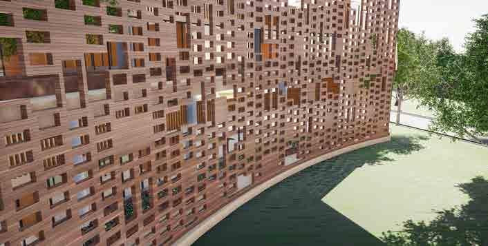
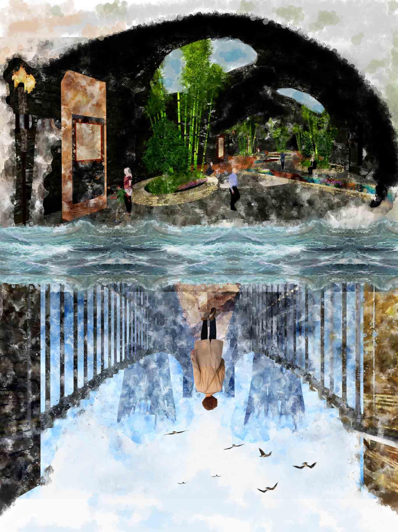
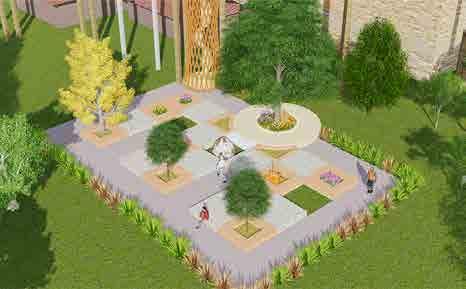
DIVERGING COALITION

An outwardly open expression of modernity connects the water tower with the sites on either sides of the roads. This contrast achieved through materials and a fluid shape not only highlights the water tower but also creates a sense of connective ownership and gratitude towards it. Thus we conserve the identity of the structure while leading it to modernity.
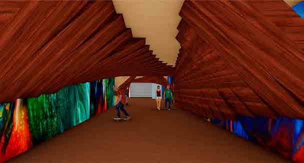
Subway was designed considering the rising hip hop culture in the nearby slum and hence is given a trendy and modern internal layout resembling the geometry of bridge for people to practice rap & graffitis.
The street along the water tower is designed largely with seating spaces and some parking spaces, keeping in mind the I.T sector workers for them to relax and detach from work environments.

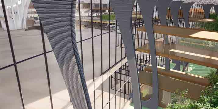
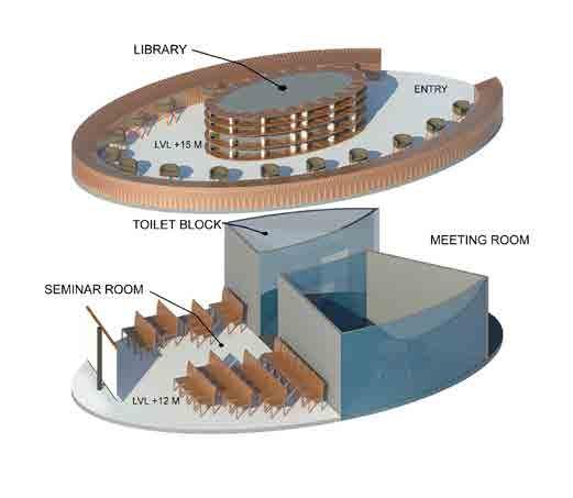
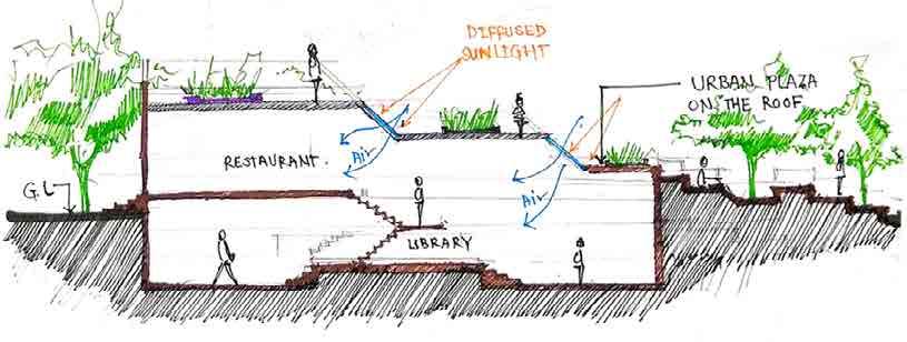
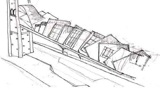
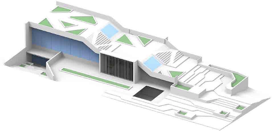
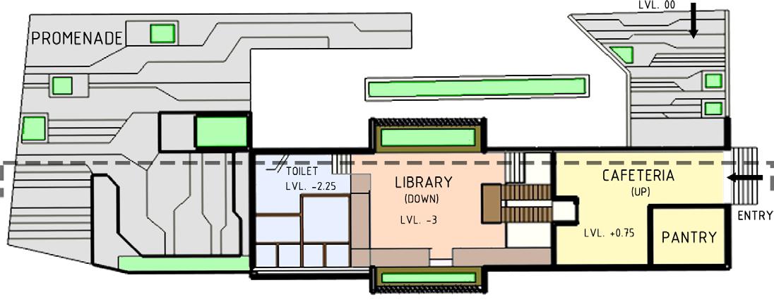
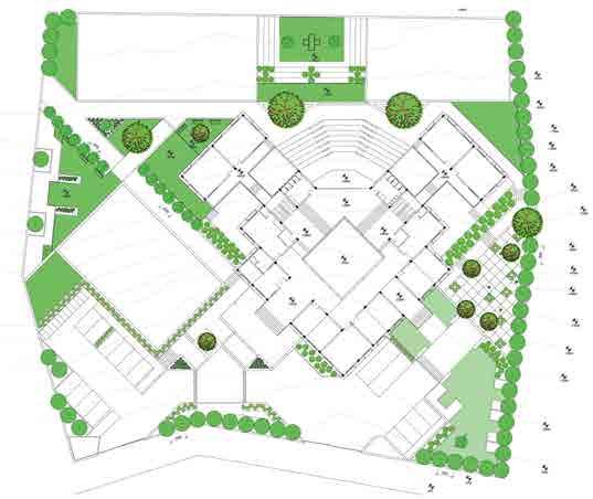
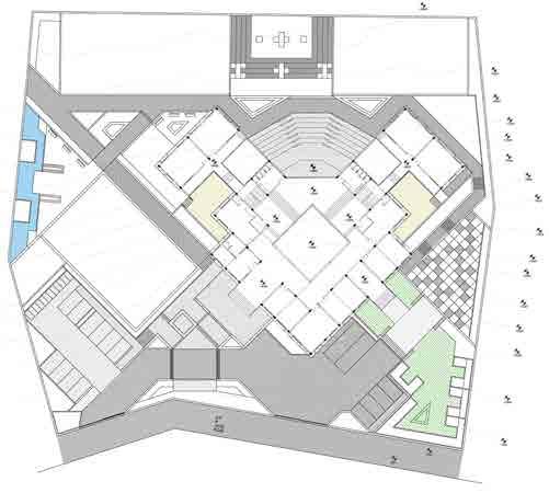
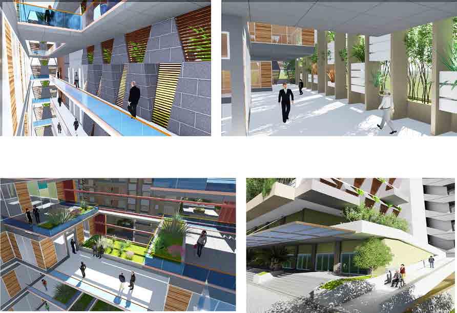
KNOWLEDGE CENTRE
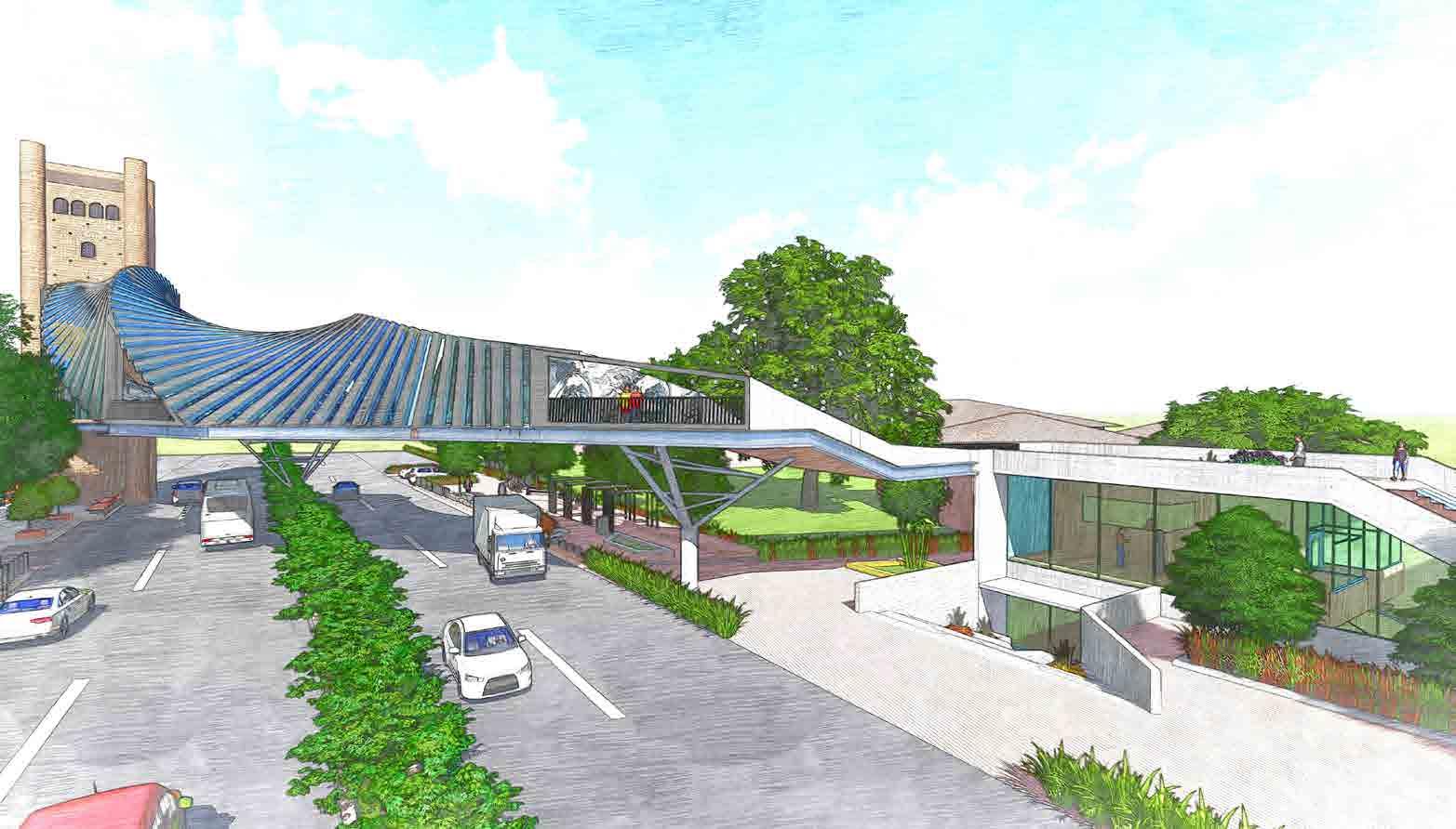
The knowledge centre stands partially underground creating double height & clearstory volumes which bring in natural light. The knowledge structure is designed on sustainable design strategies oriented along the northern side maximising north light intake and slits to create stack effect. The roof of the knowledge centre acts as a connecting plaza to the bridge. The partially green roof acts as a huge ramp connecting to the bridge making it an universal yet creative design.
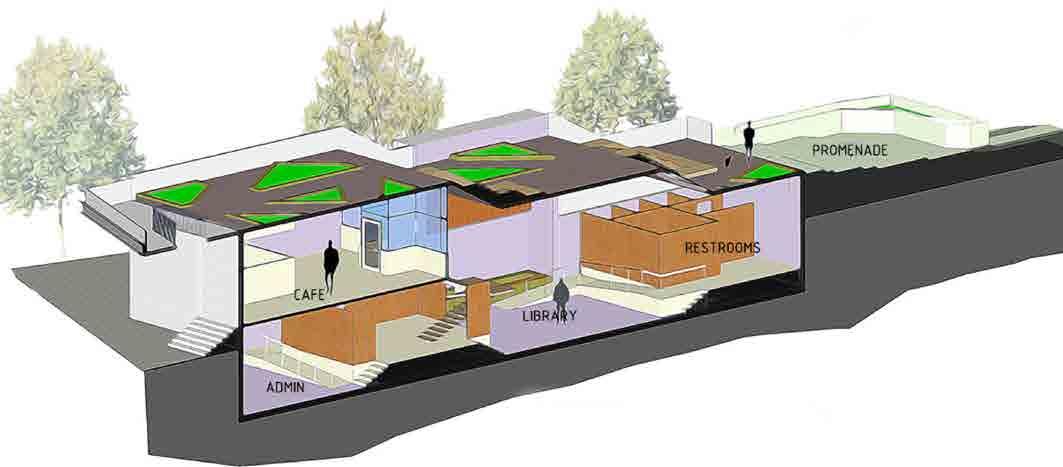
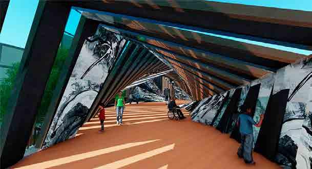
Aluminium skin facade on the interiors houses the display for the gallery inside the bridge.
Bridge connects the water tower with the site on the opposite side and stands as a symbol of modernity. It occupies part of the knowledge centre with fluid display spaces.
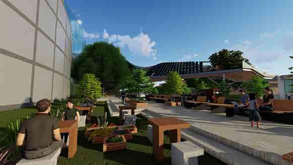
Large promenades and open spaces at the entrance of knowledge centre are designed to increase interaction between people and the structure.
Glass battens fit in between two metal battens creating interesting lighting patterns.
Steel box sections are intricately connected to form the skeletal of the bridge with various punctures and spaces for glass to fit in.
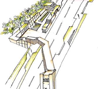
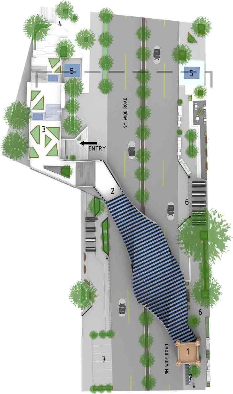
Site View Display gallery Subway 30mRoad Streetscape Knowledge Centre Water Tower
Longitudinal Section
Legend : 1. Water tower 2. Gallery 3. Cafe / knowledge center 4. Promenade 5. Subway 6. Streetscape 7. Parking Site Plan
Ground Floor Plan
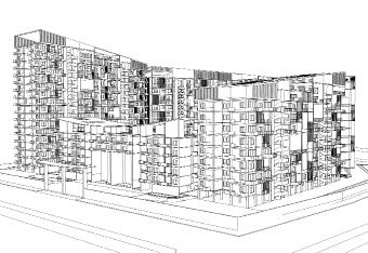
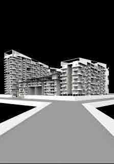
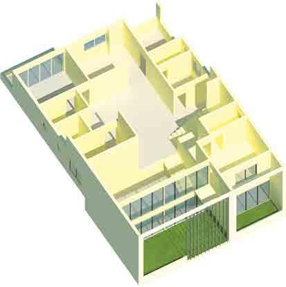
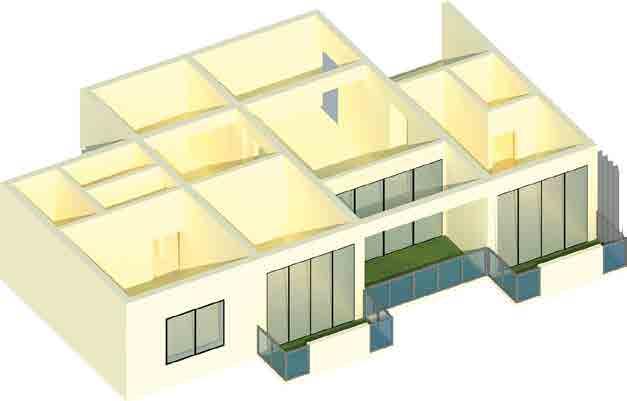
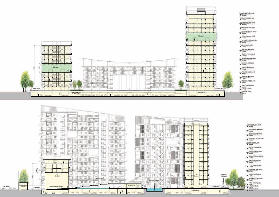
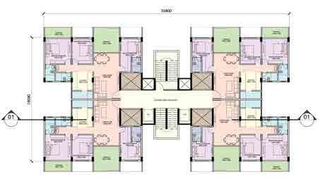
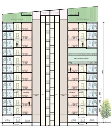
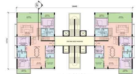
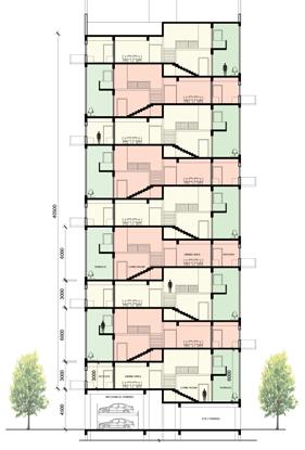
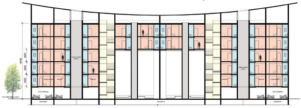
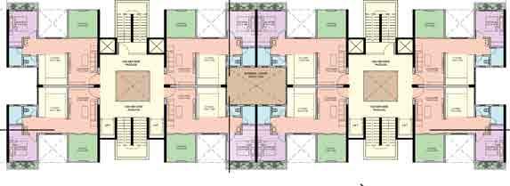
WHITE HILLS PARK
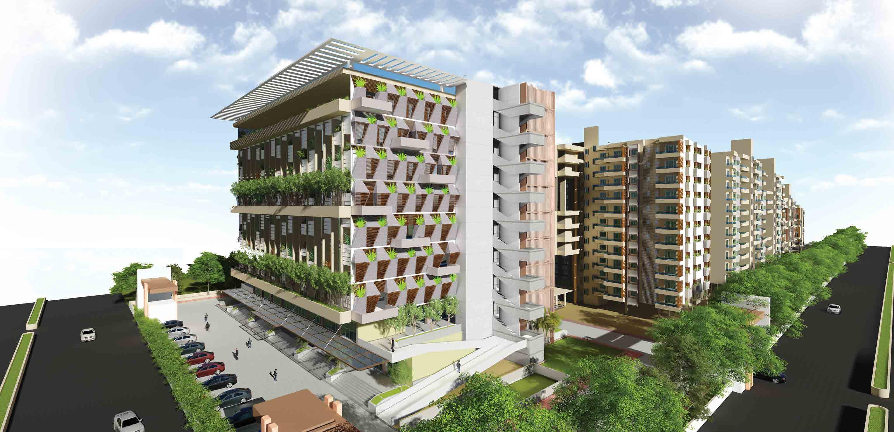
Project Category : Rental Housing
Project Year : 2019
Role : Conception, Plans, 3D visualisation
Location : Hingewadi, India
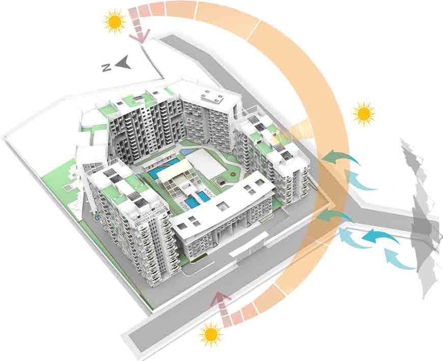
The Rental Housing Scheme project in Hinjewadi has a robust demand owing to its Growth factor.
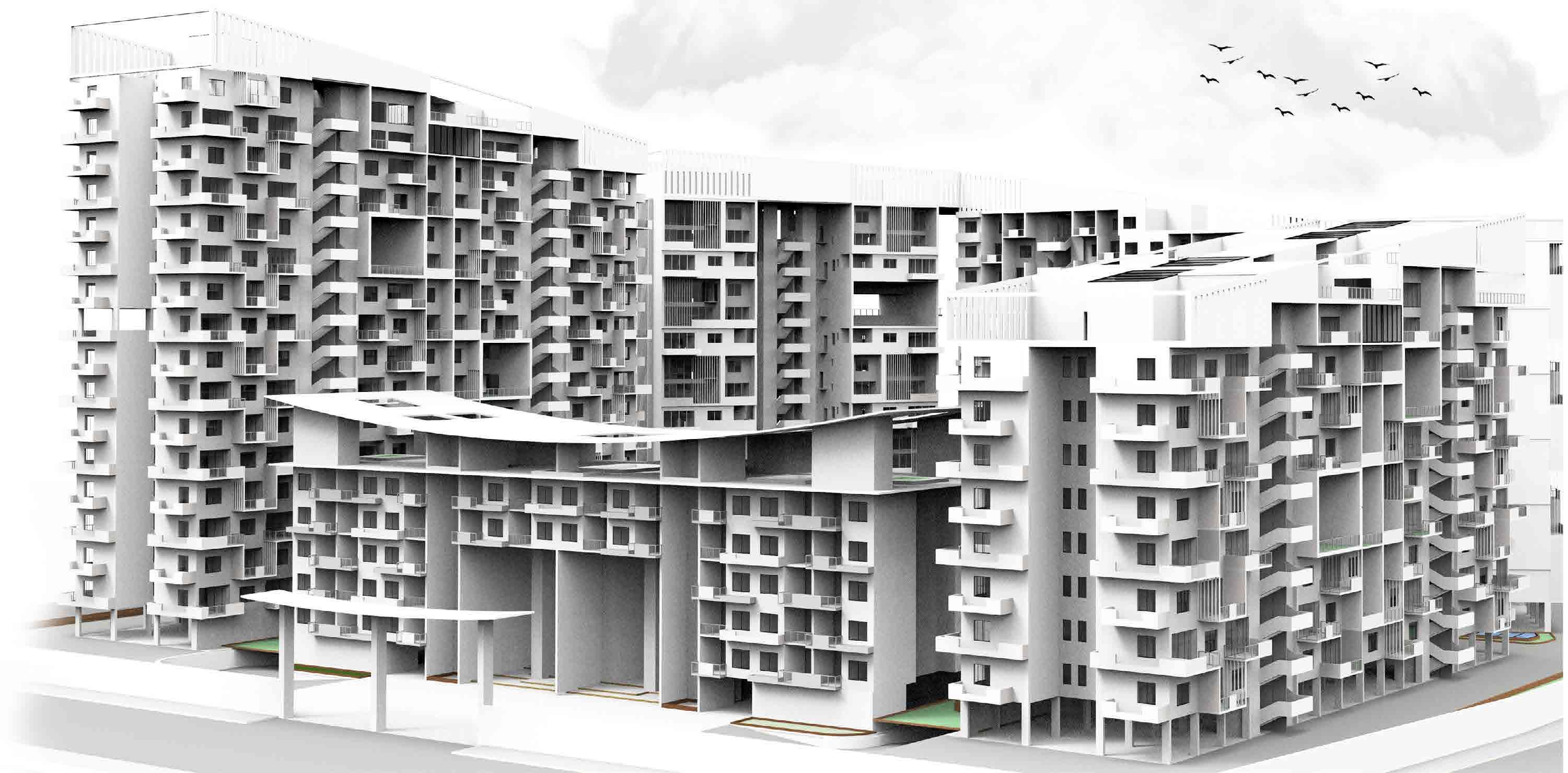
The rental housing scheme places a greater emphasis on the connectivity of the rental housing properties which focuses on creating such units in the outskirts. Emphasis on connectivity to the Industrial and IT hubs also creates potential for employment and hence better quality of life.
Planning is done in such a way that each building will get a view of hills on the south west side of the site.
Hierarchy in height is maintained in massing by keeping low rise structure near road and high rise in opposite end.
An axis is created from the road jucntion from which a whole structure will be seen from a single point.
Terraces are created through the vertical mass with the vegetation and greenary which will act as public gathering places.
The idea of receiving natural light and ventilation through carved terraces from building mass.
Creating
Hierarchy in Height Creating Interactive Terraces
Corner Site - 32970 sq.m
An Axis Maintaining
The structure has been designed in with respect to its elevation to make it more efficient in terms of the sunlight, wind and also enchancing the spatial quality of the spaces with the views. The mass here gives the definition to the structure rather than the planning.
Corner Site - 32970 sq.m Defining EWS and Amenity space. Defining open space and internal road.
COMMUNITY ENHANCEMENT
Green terraced spaces form a community space for the habitants giving the pleasant views of the adjascent hills. The central courtyard also acts as community space allowing all income groups to mix and live together.
TERRACE
GARDEN
HIG (4 bhk)
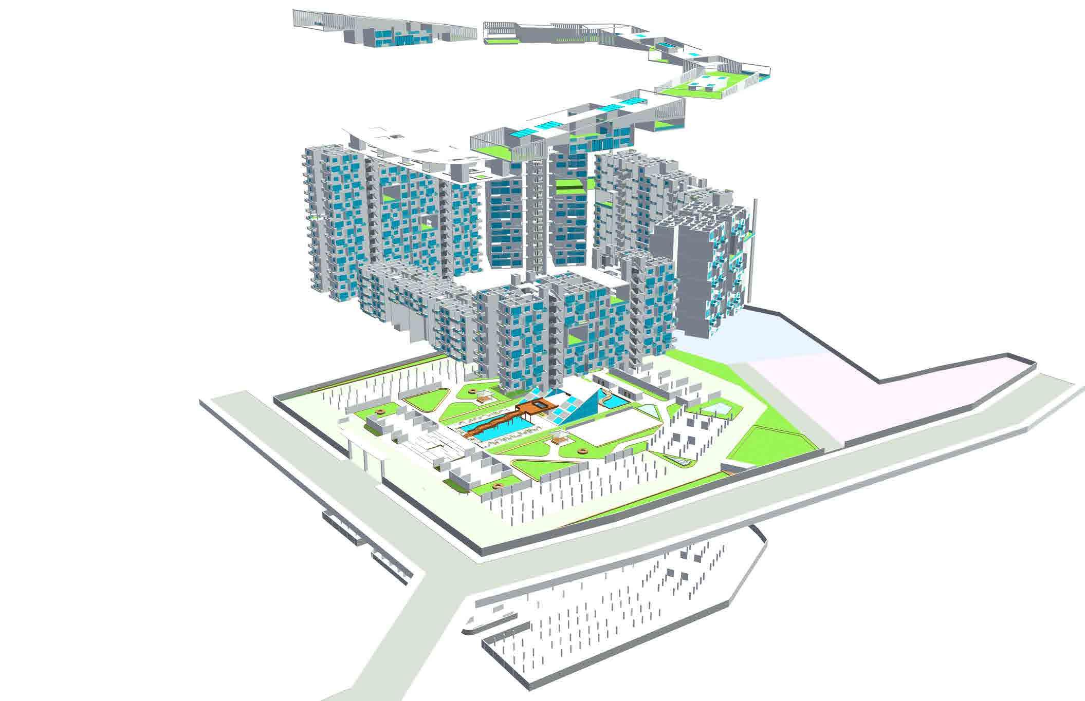
Building Block Placement along the central open space.
Arranging the blocks according to the concept.
MIG (2 bhk)
LIG (STUDIO)
STILT PARKING CLUBHOUSE
TERRACE GARDEN
LIG (1 bhk)

MIG (3 bhk) EWS 20%
MIG (2 bhk)
21 M MAIN ROAD
AMENITY 15% BASEMENT
Sun path and Wind analysis
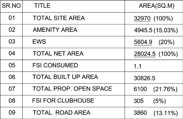
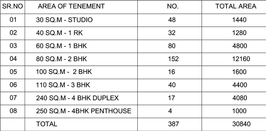
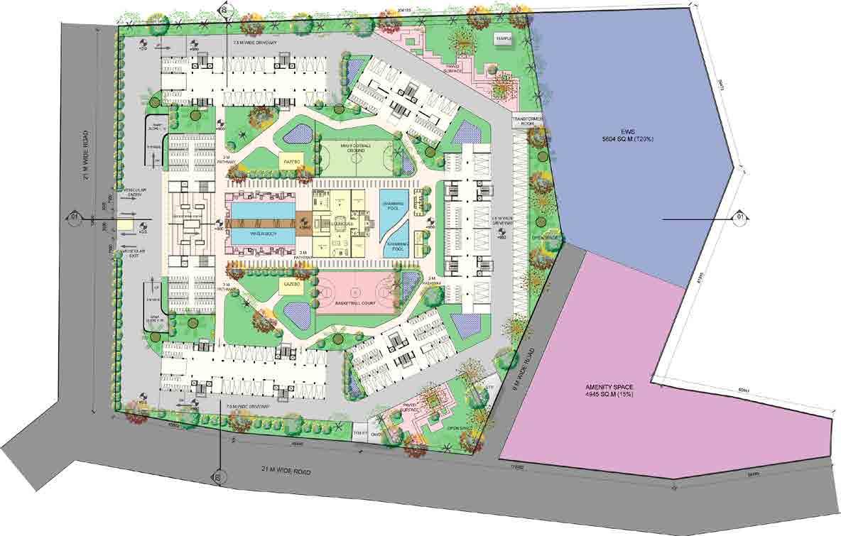


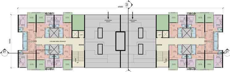
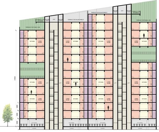

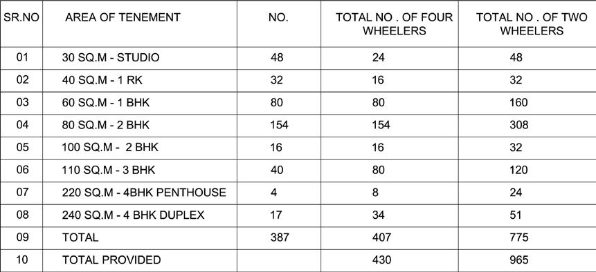
SITE PLAN BUILT MASS 5600 SQ.M (20%) SITE SECTION 01 PLAN OF BLOCK A (LIG) STUDIO - 25 SQ.M 1 RK - 35 SQ.M 1 BHK 600 SQ.M 2 BHK 800 SQ.M 2 BHK - 1000 SQ.M 3 BHK - 120 SQ.M DUPLEX - 220SQ.M SECTION SECTION SECTION SECTION SECTION PLAN OF BLOCK D (1 BHK) PLAN OF BLOCK B&F (2 BHK) PLAN OF BLOCKC (3 BHK) PLAN OF BLOCK E (DUPLEX) SITE SECTION 02 GREEN AREAS CONCRETE ROAD (13%) PAVED SURFACE (5%)
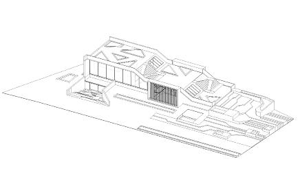
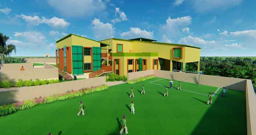
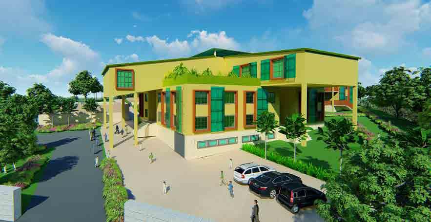
RELIANCE FOUNDATION
SCHOOL
Project Category : Higher Secondary School
Project Year : 2018
Role : Conception, Plans, 3D visualisation
Location : Panchgani, India
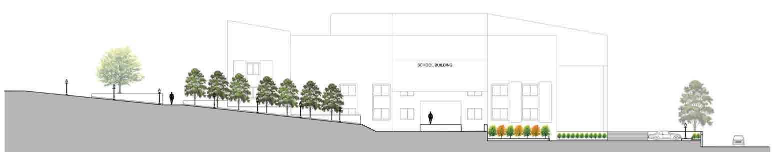
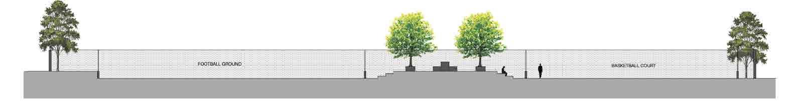
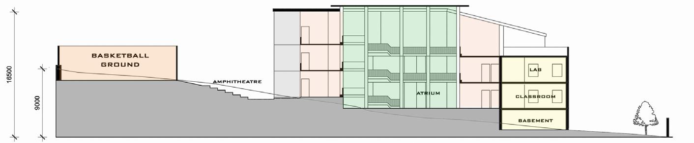
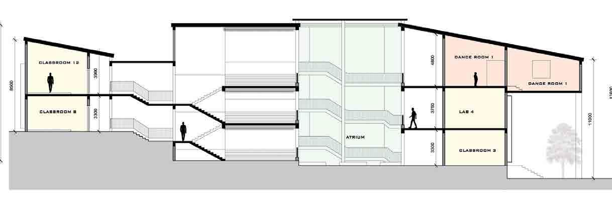
Site is located in panchgani and has steep slopes.
The initial idea was to retain these slopes to maximum extent. This helped in the basic zoning of plan. The idea of axial and symmetrical planning is putfortch keeping this concept in mind.
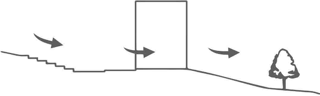
I sloped the building down from the hill and added an amphitheatre to merge the hill and integrate that with the building.
This allowed me to integrate the atrium as green zone bring the hill into the building and take views out from the atrium and from the rooms into the landscape.
The amphitheatre and atrium are the focal points of the design. If the user is standing in one of these focal point can experience the concept and observe the whole slope of the site.
Atrium Amphitheatre Entry Exit Structure’s Atrium Amphitheatre Landscape Conceptual Section Stage 1 Stage 2 Stage 3

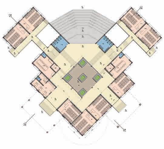
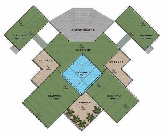


Plantation Layout Hardscape Layout Site Plan Site Section Section 1 Section 2 Section 3 Section 4 Section 5 Section through Atrium Roof Plan Second Floor Plan First Floor Plan 3 5 4 2 1
EXPERION COMPLEX
Project Category : Commercial Complex
Project Year : 2017
Role : Conception, Plans, 3D visualisation

Location : Lucknow, India
Building plan uses steel framing with integrated planning to achieve mutual shading.
The building is oriented along the north south axis to reduce the solar radiation on the eastern and western facades.
This strategy allowed us to capture the diffused north light.
Elevators, fire staircases, toilets are strategically placed on eastern and western sides of building creating a buffer.
The different office building styles are provided to cater to the diversity of work fields yet unified
North- South oriented commercial block
Integrated communal spaces for diferent offices and shops
Maximum openings on Northern side for better light and ventilation
Creating projections on Southern side for mutual shading
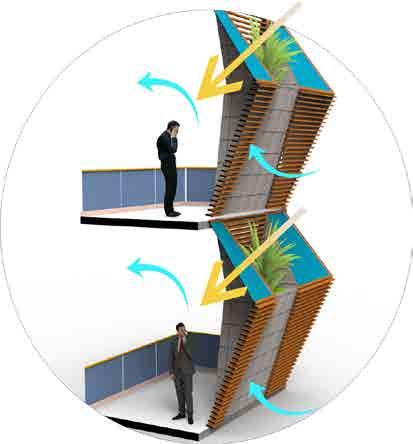
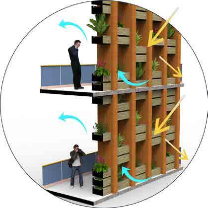
EAST & WEST FACADE :
Angular surface is designed incorporating a system of louvers and planter pods which maintain ventilation while minimizing the solar glare of the surface.

NORTH SIDE FACADE:
combination of glass and wooden panels to achieve optimum intake of light. A retractable wooden façade is provided which can completely opened or closed to tackle smog and extreme weather conditions.
SOUTH FACADE:
In order to tackle harsh glare of southern side, floor plates are projected outward creating mutual shading. louvers with planter pods protect against the glare and heat gain while creating a healthy green environment.
VERTICAL ZONING:

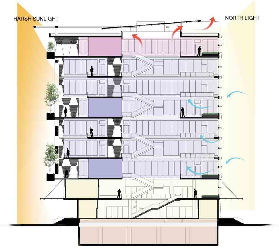
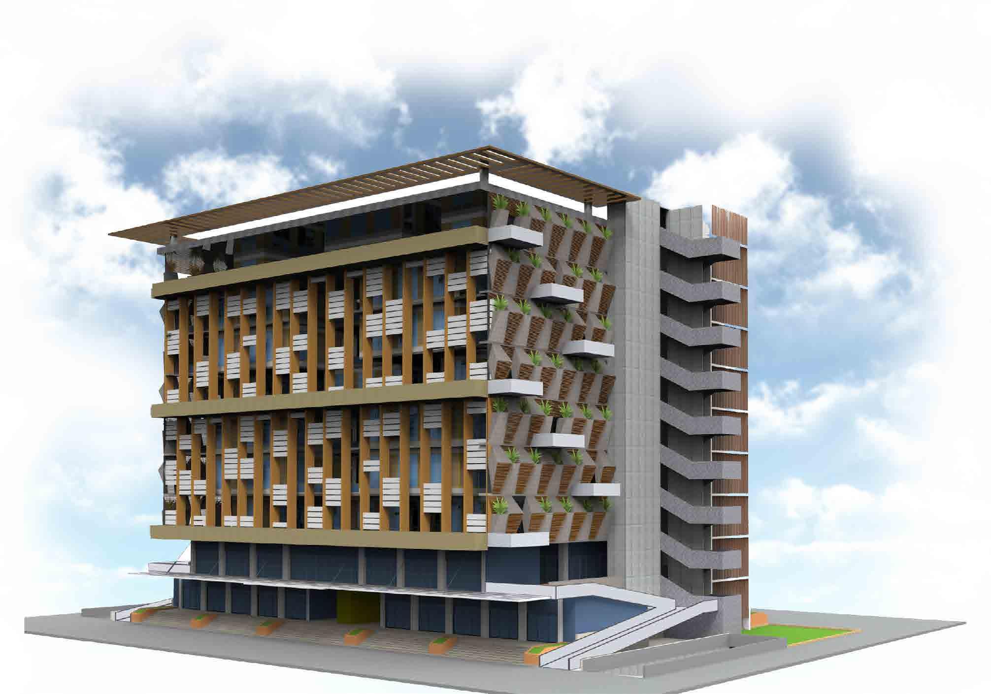
The lower couple of floors are designed with retail shops to provide a barrier free environment as they face maximum footfall.
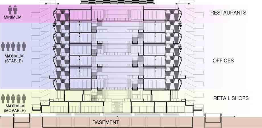
The central 6 floors are office spaces with a combination of group office spaces for productive environments and individual office for focused environment.
Each of the office floors is designed to look over green zones. The restaurant is placed on the top floor to create a private and casual environment for its users.
SECTION
Interactive spaces with landscape Providing barrier free Environments
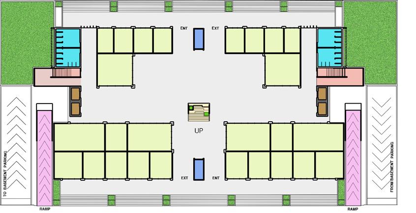
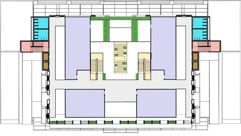
SEVENTH FLOOR PLAN GROUND FLOOR PLAN
Green facades providing good light and ventilatiion and Creating pleasant environment in passages
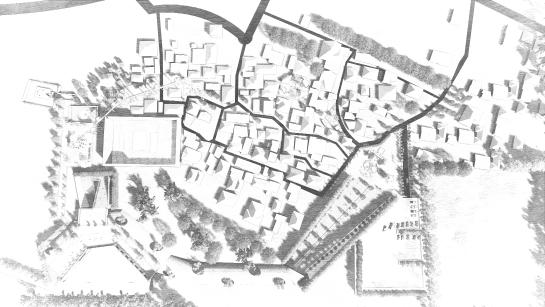
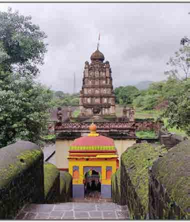
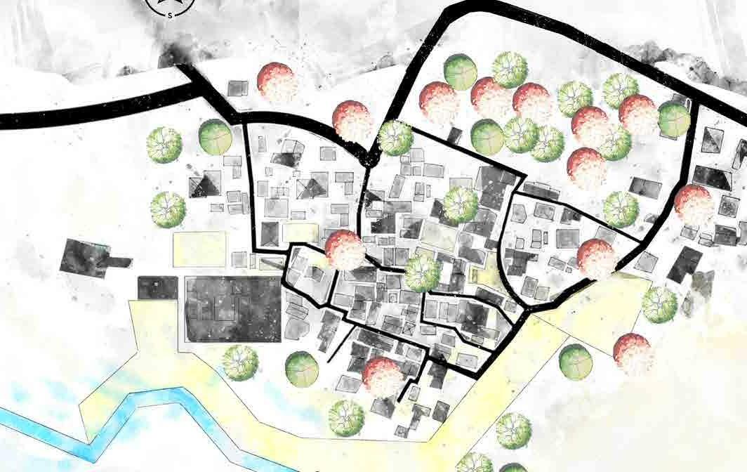
VILLAGE IN THE FOREST
Project Category : Redevelopment Of Ranje Village
Project Year : 2017
Role : Conception, Plans, 3D visualisation
Location : Pune, India
The brief asks us to interpret and understand the core fabric of a village structure and experience the nitty-gritty of the village architecture and settlements. It calls for an enquiry of the core elements of the village habitat and the necessary processes that are comprehended in the day to day lives of the villagers.
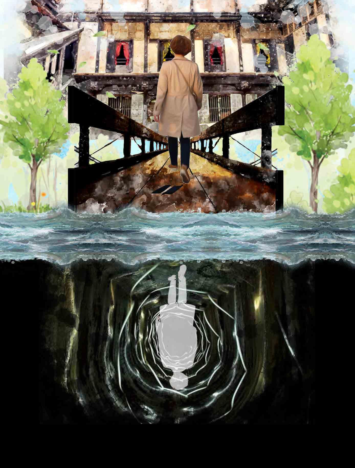
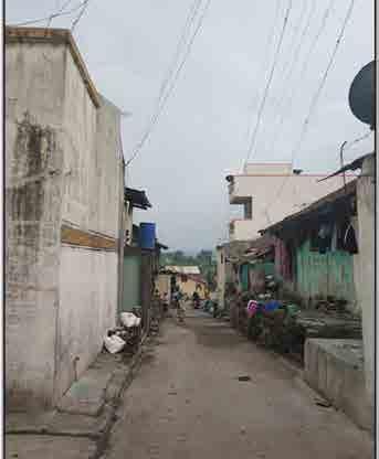
Ranje village is located in bhor tehsil of pune district of maharashtra. It is situated 28 km away from the district headquarter of pune.
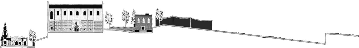
The village settlement of ranje, is one among the many tarditional villages that dot the clusters of villages on the banks of khadakwasla dam. Its settlement dates back to as early as mid 1600s during the peshwa reigns of maratha empire. Sandwiched between the sinhgad fort and the khadakwasla dam, the early village inhabitants used to be a part of the infantry units of peshwai before switching to agriculture for livelihoods. This agricultural activity was accomodated by clearing the surrounding forest of the village which resulted on large scale deforestation since last 50 years. There was a clear need to bring back the forest into the village.
The design intervention focuses on to bring a positive result in terms of bringing back the lost traditional and cultural values of the village. The design intervention approach is done keeping in mind the sustainable design concept through salvage and adaptive use of resources to propose creative and aesthetic design elements.
“Every little village in the world there are great potential champions who only need motivation, development and good exercise evaluation.” – Arthur lyllard
Community

Market place – since the economy of the village needed a major boost, a formal market is dedicated to the trading activities of the farmers where they sell their local produce. Small vendors have been alloted a space under the pergola whereas a dedicated covered space is used vendors of large scale trade activity.
The village settlement of ranje, is one among the many tarditional villages that dot the clusters of villages on the banks of khadakwasla dam. Its settlement dates back to as early as mid 1600s during the peshwa reigns of maratha empire. Sandwiched between the sinhgad fort and the khadakwasla dam, the early village inhabitants used to be a part of the infantry units of peshwai before switching to agriculture for livelihoods. This agricultural activity was accomodated by clearing the surrounding forest of the village which resulted on large scale deforestation since last 50 years. There was a clear need to bring back the forest into the village.


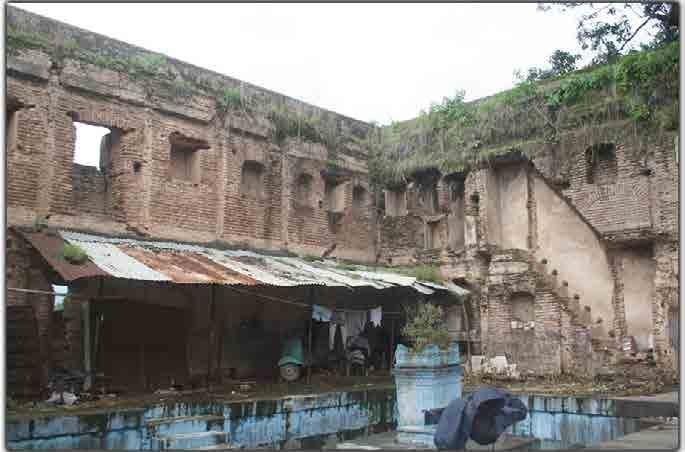
Design concept is derived from the feeling of bringing the forest and cultural tradition back to the village. The village having such a strong history and background had lost its assets to the social pressures of development and growth. Hence there arose a need to reactivate the core elements that make this village’s character and identity ( social and economical , political and administrative cultural and religious, geographical and architectural ). major focus is established to bring the lost forest cover back to the village along with new sustainable design proposals that are salvaged from the wreck and reused to build architectural elements.
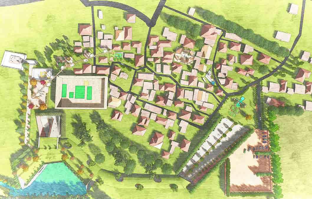
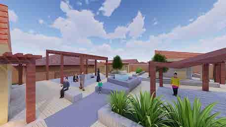
 space – a community gathering space for the gram panchayat is dedicated to create an environment of interaction between the village inhabitants and also a place to discuss administrative/political issues with the common public.
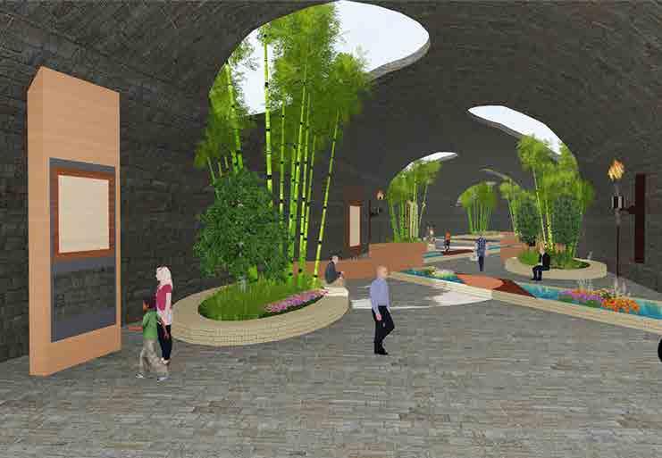
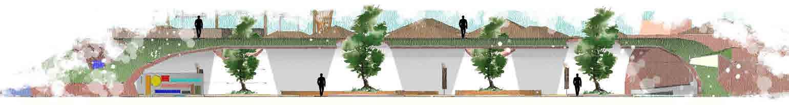
Tunnel – a derelict tunnel is reactivated as a tourist hub to increase the economic activity of the village and bring in the required footfall for tourism. The natural slope of the tunnel is maintained to prevent any site disturbances. The treated water which comes from the aerobic water treatment plant is further treated with root zone treatment system (rzts) which uses biological and physical treatment processes to remove pollutants from waste water.
space – a community gathering space for the gram panchayat is dedicated to create an environment of interaction between the village inhabitants and also a place to discuss administrative/political issues with the common public.
Tunnel – a derelict tunnel is reactivated as a tourist hub to increase the economic activity of the village and bring in the required footfall for tourism. The natural slope of the tunnel is maintained to prevent any site disturbances. The treated water which comes from the aerobic water treatment plant is further treated with root zone treatment system (rzts) which uses biological and physical treatment processes to remove pollutants from waste water.
View Of Sky Bridge
Washing area- Washing area is proposed, water of which area is recycled in layers of water treatment systems and reused in the landscape.
Mid 1600 Late 1800 Present
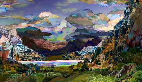
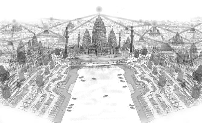
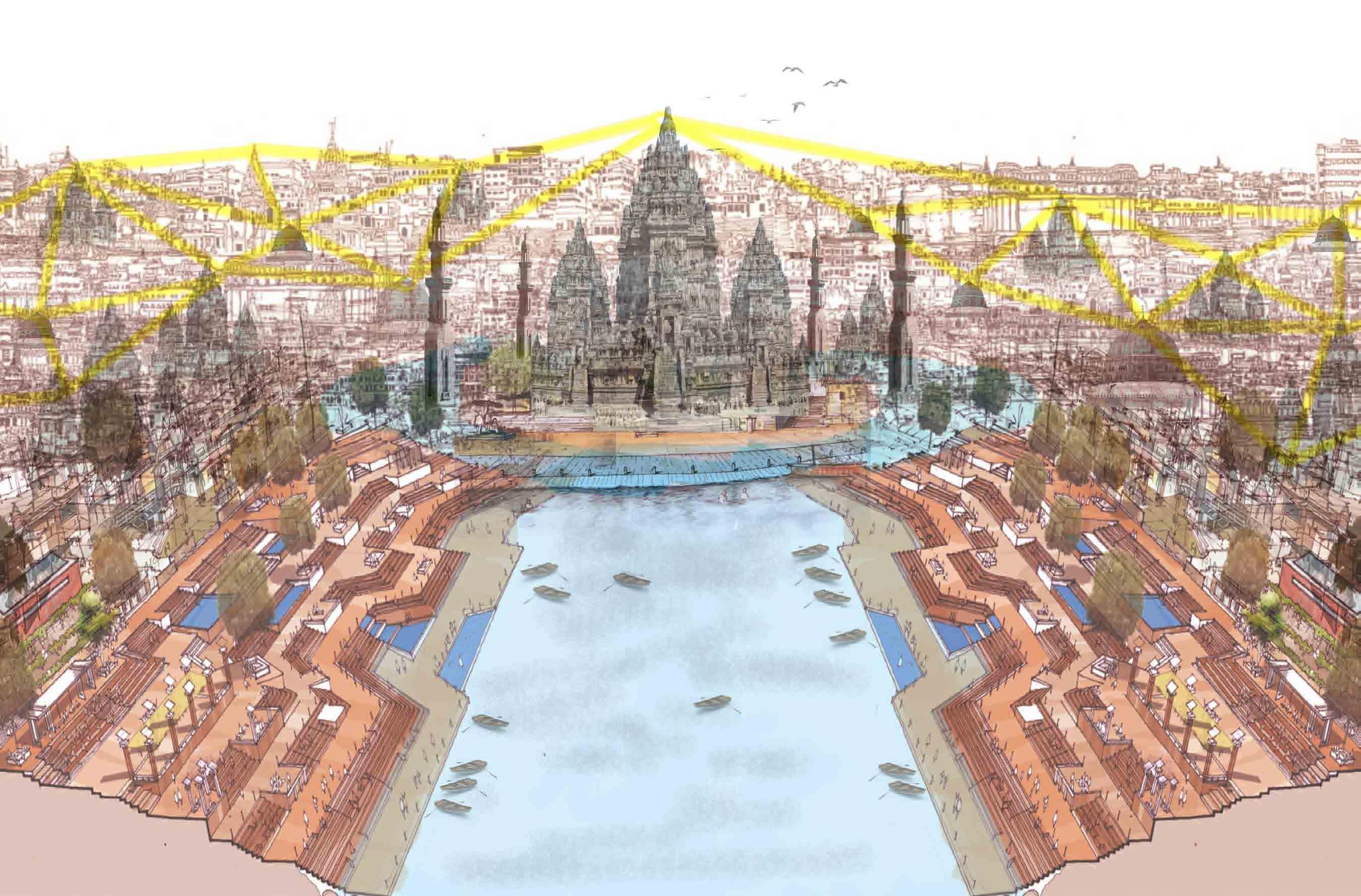
Antara Hyperreal City
Project Category : Hyperreal City
Project Year : 2020
Role : Conception, Cartography
Location : Varanasi, India
If one were to examine the nature of India’s cities in this post-truth era, it would indeed be possible to draw parallels to Jean Baudrillard’s concept from 1983 - hyperreality. To quote Baudrillard from his book Simulacra and Simulation- ‘Today, abstraction is no longer that of the map, the double, the mirror, or the concept. Simulation is no longer that of a territory, a referential being, or a substance. It is the generation by models of a real without origin or reality: a hyperreal.’
The brief aims to choose any Indian city of your choice to work with. However, the city needs to be real and existing on the ground. The city area to be mapped must be 100 square kilometers. You may choose a city that is much larger than 100 square kilometers but must then delineate a 100 square kilometer area within that city and work only with this area.
It must elucidate through a single cartographic representation of the chosen city as it stands today, an understanding of its urban morphology and a minimum of one other urban design dimension –functional, temporal, visual, perceptual or social. Subsequent to this, teams must create a single cartographic representation of an imagined cityscape - a hyperreal city – where ‘the territory no longer precedes the map, it is the map that engenders the territory’ (Baudrillard, 1983).
“Cartography can be an incredible form of escapism, as maps act as proxies for experiences.”
Antonis Antoniou
Varanasi
A CITY OLDER THAN HISTORY
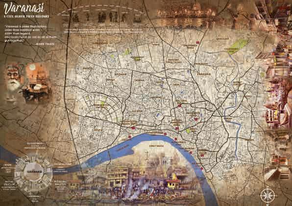
Varanasi, also known as Banaras, or Benaras or Kashi or Kasi, is a famous Hindu holy city situated on the banks of the river Ganges in the Indian state of Uttar Pradesh. The city is called Kasi, “the luminous” in the Rigveda. It is often referred to as “city of temples and learning.“
It is the oldest living city and is heterogeneous with multiple layers of religion, culture, art forms, believes nature, profiles and individualities. It is a sacred and holy place to Hindu, Buddhist, Jain and Muslim religion. It is also the home to numerous religious monuments (4000 temples, 300 mosques) and is famous as a centre of music, arts, crafts, education and learning.
The culture of Varanasi is deeply related with the river Ganga and the river’s religious importance. Varanasi is known mainly for its ghats and is the religious bathing place for the pilgrims. The city has been a cultural and religious centre in northern India for thousands of years. Varanasi has its own style of classical Hindustani music, and has produced prominent philosophers, poets, writers and musicians in Indian history.
-MARK TWAIN
“Varanasi is older than history, older than tradition even older than legend and looks twice as old as all of theput together.”
Antara
A CITY BEYOND LIFE
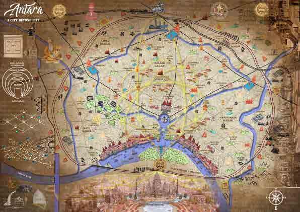
A place where Fire, Water, Earth and Air come together with the Soul/Spirit.
A place where the Temples and Ghats are not just Religion places but the Emotion, the Bhavna of the City.
A place where darkness cannot endure, neither in the people’s Soul nor in the City.
A place where the energy is absorbed and reused in a way that brings light even in the time of Darkness.
The First rays of Sun that strikes the City of temples and Ghats which has the phenomenal power to absorb that Energy and illuminate the whole city in times of Darkness through the Temples.
The Antara is a gateway to heaven as people come here to acquire moksh and free themself from the cycle of life and death.