

Transalp Alpe di Susi
A mountain bike tour through the World Heritage Site 6 stages - 230 km - 6000 m elevation gain
Level 2-3

The specialist for alpine crossings
www.go-alps.com
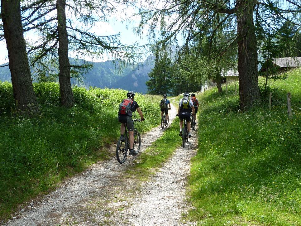
World Heritage up close
The Dolomites Unesco World Heritage Site provides the perfect setting for our Transalp Alpe di Siusi. We enjoy a super panorama every day, without having to pedal the altitude meters otherwise required for this completely under our own steam. The cable car transfers make this possible. The larch forests on the Salten, Merano 2000, the Rittner Horn, Alpe di Sissi, and as a finale Catinaccio and Lake Carezza are just five highlights on the route. We also spend the night at the very top twice. Comfortably at Merano 2000 and with the romance of mountain huts, partly in multi-bed rooms on the Alpe di Siusi. Let us surprise you.
The tour video on YouTube: https://www.youtube.com/watch?v=jlwispppKt4&t=14s
A unique round
Even if the cable car transfers suggest this: The Transalp Alpe di Siusi is not a trail or downhill tour. We master many descents on small asphalt roads. Nevertheless, there are trails of course. The tour shows us many of the beauties of the Dolomites.
Simply awesome!

www.go-alps.com
6 stages - 230 km - 6000 m elevation gain:

Simply exhilarating
Anyone who loved our Transalp Engadin or Three Peaks will love this tour. On this Dolomites tour, we cycle almost every day at an altitude of over 2000 meters on the best MTB trails. Thanks to the cable car transfers, we are always in a high alpine landscape without having to pedal the otherwise necessary 2000 meters of altitude completely under our own steam. The daily sta ges of this level 2-3 mountain bike tour vary bet ween 40 and 60 kilometers with 800 to 1250 me ters of altitude. That sounds easier than the tour is. During our tour check, we were always really tired in the evening. Some beautiful trails await us on the mostly long descents. Even so, the route never gets too extreme, as we speed downhill on small asphalt roads for parts of the tour. Simply exhilarating.
Hermann Pichler, ALPS-Guide
www.go-alps.com
Highlight No 1:
View into the Vinschgau Valley

www.go-alps.com
www.go-alps.com

Highlight No 2: Merano 2000

Highlight No 3: Cairns

www.go-alps.com
Highlight No 4: Rittner Horn
www.go-alps.com

www.go-alps.com
Highlight No 5: Villanders
www.go-alps.com
Highlight

www.go-alps.com
No 6: The Eisack Valley
www.go-alps.com

Highlight No 7: Alpe
di Siusi
Highlight No 8: The Duron valley

www.go-alps.com
www.go-alps.com
Highlight No 9: Catinaccio and Latemar

www.go-alps.com
www.go-alps.com

www.go-alps.com
www.go-alps.com
Highlight No 10: Descent to Bolzano
Elevation profile day 1

www.go-alps.com
Transalp Alpe di Siusi 1. stage - 35 km - 1150 m elevation gain
From Nals to Falzeben/Merano 2000
www.go-alps.com
1. Stage From Nals to Merano 2000
35 km 1150 m elevation gain
We start in Nals with the finest breakfast in the Dolomites. This is also where our annual season finale takes place. A short roll-in in the morning to the cable car. This takes us up to the Salten. The Saltner Rücken with its magnificent larch forests inspires us right up to the cappuccino break. However, the sweating continues. Interesting views of the Adige Valley open up again and again. We get higher and higher.
Right next to our inn is the pilgrimage church of St. Jakob, first mentioned around 1300. It's worth taking a look inside. Then, we continue uphill towards the Vöraner Joch. Our highest point is just under 1700 meters. From now on, it's all downhill. We reach our lunch spot, the Leadner Alm, via wonderful forest paths and small trails. The cuisine leaves nothing to be desired. The view is also sensational. This is what we imagined a holiday to be like. But we haven't finished for the day yet. We speed down through the forest to Hafling, the home of the robust moun-
Highlights today
• Larch forests on the Salten
• Lunch break at the Leander Alm
• Blick ins Eisacktal und Vinschgau
• Climb to Merano 2000
• Hafling and its famous horses
tain horses. The South Tyrolean landscape delights us, and at the same time challenges us on the short but steep ramps. Hafling is also known for its famous Knottnkino cinema, which the artist Franz Messner installed here in 2000. Film enthusiasts can experience the entire Adige Valley, the Penegal, the Weisshorn, the Texel Group, the Merano basin, the Passeier Valley and the Dolomites. We also get to enjoy this fabulous panorama on our route, although we still have to climb 300 meters in altitude. But the view makes up for all the effort. We are also motivated by another view: our wellness hotel in the small ski resort of Falzeben, right at the entrance to the Merano 2000 ski area.
www.go-alps.com


Route requirement day 1. - 35 km - 1150 m elevation gain
A day with all MTB elements. We start off on asphalt cycle paths and small asphalt roads. From Salten, the route climbs steeply into the forest in parts on gravel. However, the surface up to the cappuccino break is always good and without any technical acrobatics. This changes in short sections before the lunch break. Nice trails and rooty passages challenge our strength. There are also some steep climbs. Some of us even have to push for short sections. The forest path to the Leadner Alm is first class. After the lunch break, we first ride downhill on forest paths and then uphill on asphalt to the hotel. Traffic is limited on this last section. In the afternoon, hikers usually hike downhill and come our way.
www.go-alps.com
The Salten with its magnificent larch forests and views of the Adige Valley.


www.go-alps.com
A regular means of transportation: the cable car to Jenesien. Short trail passages are part of this day.

A great lookout point into the Vinschgau Valley and the Penegal.

This is also worth all the effort. Our hotel in Falzeben.
www.go-alps.com
Elevation profile day 2

www.go-alps.com
Transalp Alpe di Siusi 2. stage - 30 km - 800 m elevation gain
From Falzeben/Merano 2000 to Astfeld/Sarntal valley
www.go-alps.com
2. Stage From Merano 2000 to Sarntal valley
30 km 800 m elevation gain
Faceing the rugged mountain peaks of Merano 2000, it is even easy to say goodbye to our beautiful hotel. But thanks to today's performance, we can enjoy breakfast in peace and quiet. We climb 400 meters up to the mountain station and then reach the spectacular panoramic region. The 2700-metrehigh Monte Ivigna is close enough to touch. Plattingerspitze, Great Mittager and the Hirzer in the background are also impressive. The number of hikers who want to enjoy the view up here, like us, is still limited. We quickly move on with our bikes. A cappuccino stop at the Meraner Hut at an altitude of almost 2000 meters is mandatory. Afterwards, a wonderful, partly technical high-altitude trail leads over the Kreuzjoch to our lunch break. The Vöraner Alp is not only popular amongst mountain bikers. The landlord spoils us with typical specialties. Bacon dumpling soup or Kaiserschmarrn pan-
Highlights today
• Super breakfast at the hotel
• Merano 2000 and Merano Hut
• High trail to the Kreuzjoch
• Cult place Cairns
• Lonely Öttenbach valley
cakes have rarely tasted better. It is difficult to leave this welcoming place. But it's worth setting off. We set our sights on the legendary Cairns. Once again, we enjoy a wonderful high-altitude trail with a sensational panorama and the best MTB surface. Just below the mystical-looking stones, the curtain rises for the mountain world of the Dolomites. With a bit of luck, we can see all the peaks lined up like a string of pearls. A short push and we are at the top. Generations of hikers have piled up hundreds of stone pillars at this place. Court records from the early 1540s state that witches' dances and devil's parties were held between the stone statues. Whether you want to believe this is up to you. However, the mystical atmosphere cannot be denied.
From here we start the long descent down into the Sarntal valley. We might stop again at the Auener Alp, 1800 meters above sea level. It's just too beautiful up here.
www.go-alps.com


Route requirement day 2. - 30 km - 800 m elevation gain
This day is characterized by high alpine terrain. We start on a wide forest road, which climbs steeply for 400 meters. However, the gradient is easy to ride, and there is always time for a short stop. The super panorama and well-maintained hiking paths with a gravel surface await us at the top. Downhill, some loose gravel demands our full concentration. The ridgeway after the cappuccino break is considered by many to be one of the most beautiful panoramic routs in South Tyrol. Nevertheless, in parts it is not easy to ride. Wide enough for hikers and mountain bikers, it is important to show consideration for others at all times. As we get closer to the Kreuzjoch, we meet fewer hikers on the trail. After the lunch break, we continue on the best MTB trails. A short pushing section up to the Cairns and then it's basically all downhill. Initially a little technical through the stone pillars, then downhill on rough gravel, which gets better and better. We cross over into the Öttenbach valley on a narrow forest path and from an altitude of 1700 meters the surface changes to asphalt.
www.go-alps.com
Mystical place for more than 500 years - the Cairns.


www.go-alps.com
Comfortable hiking trails in Merano 2000. The ridgeway to the Kreuzjoch is simply brilliant.


www.go-alps.com
View of the Texel Group and the Vinschgau Valley. Perfect cappuccino stop.


www.go-alps.com
Mountain biking is fun. Narrow paths on an elevation line.
The


www.go-alps.com
panorama of the Dolomites is perfect on a clear day.
Not too difficult, but still technical.
Elevation profile day 3

www.go-alps.com
Transalp Alpe di Siusi 3. stage - 45 km - 1100 m elevation gain from Astfeld/Sarntal valley to Chiusa/Eisack valley
www.go-alps.com
3. Stage From Sarntal to Chiusa
45 km 1100 m elevation gain
On the next stage, we set our sights on the Rittner Horn. Before that, we speed gently downhill through the Sarntal valley in the morning. Lush green meadows and the crystal-clear water of the Talfer river inspires us. But the fun doesn't last long. The Rittner Horn has to be climbed. On a lonely asphalt road, we gain altitude meter by altitude meter. The view into the valley gets deeper and deeper. We pass lonely hamlets and small churches. It's hard to believe that there are still houses up here. But we continue uphill through lonely forests to the Roaner farm at 1600 meters above sea level. Everyone can ride at their own pace over the last few meters of altitude. The first riders are already enjoying their cappuccino.
We continue through a picture book landscape to the valley station of the Ritten cable car, which is perfectly prepared for mountain bikers. A few minutes later we are at an altitude of almost 2100 meters. The panorama on the Cima Lago Nero is unique. All the
Highlights today
• Downhill into the Sarntal valley
• Solitary ascent to Gissmann
• Hut rest at the Rittner Horn
• Mega Dolomite panorama
• Tricky Waal path
peaks of the Dolomites spread out before us. A few more meters in altitude and we reach the well-deserved lunch break. The Feldtuner Hut is situated in a unique location. With a heavy heart we leave the comfortable deckchairs behind. The next few meters quickly make us forget them. The ridgeways around the Rittner Horn inspire everyone and are made for mountain biking. We pass the Sattelberg and slowly descend. From here it's 1600 meters downhill. Hence, there is enough time on the descent to enjoy the view. Maybe we’ll stop for a quick coffee at the "Moar in Plun"? A restaurant could hardly be more beautiful. Besides, the so-called Waal path begins shortly afterwards, a extraordinary gently sloping root trail. We can decide when we want to exit the driving pleasure. Because even a descent takes a lot of energy. At Villanders, we return to ancient paths and end up right in the heart of Chiusa - the medieval town.
www.go-alps.com


Route requirement day 3. - 45 km - 1100 m elevation gain
The elevation profile already reveals the efforts of the day. There is a lot of uphill and even more downhill. If you want, you can even save the cable car and climb an extra 300 meters. The meeting point is the lunch hut. But first we take the hiking trail along the Talfer river, slightly downhill. We have to take the road for a short stretch before the long ascent begins. The small road shows its pitfalls right from the first few meters. It is really steep. Halfway up, the surface changes to gravel. However, the forest path is easy to ride. Shortly before the cappuccino break and up to the Rittner cable car, the route is asphalted again. At the top at 2000 meters, wide gravel paths stretch across the entire high plateau. It only gets a little more technical on the descent. The Waal path requires concentration and riding technique. If you prefer, you can also complete this section on the road. Eventually, there are more than 1600 meters of continuous downhill.
www.go-alps.com
View of the Dolomites from the Rittner Horn.


www.go-alps.com
Lush meadows in the Sarntal valley. Steep asphalt ascent to Gissman.


www.go-alps.com
Lonely hamlets and nice churches. View back to Merano 2000.


www.go-alps.com
Great ridgeways at the top of the Rittner Horn. The cable car helps us up the last few meters.

Is


www.go-alps.com
this view stunning? The Haflingers also feel at home up here.Elevation profile day 4

www.go-alps.com
Transalp Alpe di Susi 4. stage - 40 km - 1100 m elevation gain
From Chiusa/Eisack valley to the Alpe di Sissi
www.go-alps.com
4. Stage From Chiusa to the Alpe di Siusi
40 km 1100 m elevation gain
Early in the morning we roll through the narrow streets of the medieval town of Chiusa. The route up to the Alpe di Siusi takes time and energy. Before, we speed along the Eisack valley cycle path, always slightly downhill towards Bolzano. At Waidbruck, we change to the route of the former Brenner railroad and hurtle past the ancestral castle of the minstrel Oswald von Wolkenstein without any traffic. We cross the Eisack on old railroad bridges and marvel at the narrowness of the valley. Until the Middle Ages, the path was impassable for vehicles. The gorge was too wild and dangerous.
In Atzwang, we leave the wild narrowness and head towards the Sciliar on a small, closed road. Bolzano's local mountain looms before us like a mighty block. The river soon rushes deep below us. At Völs, it's time for a cappuccino break. We enjoy the break in St. Konstantin. The little church against the backdrop of the mighty Sciliar is one of the most frequently photogra-
Highlights today
• Ascent from the Eisack valley
• The Völser pond
• The Alpe di Siusi
• The Sciliar
• Overnight stay at the Alpe di Siusi
phed motifs in South Tyrol. From here, it is only a few meters up to the Völser pond, which was once praised as the most beautiful mountain lake in Italy. We reach the valley station of the Alpe di Siusi cable car before our lunch break. 15 minutes later we are at the top. The largest high alpine pasture in Europe spreads out before us. 64 square kilometers of pastureland. Here we can enjoy our lunch break. Then we take a spectacular panoramic tour at an altitude of 2000 meters. The Sciliar with its striking Punta Santner peak is the perfect photo motif. But many other Alpine peaks are also visible from this viewpoint. On a good day, the view stretches from the Fanes to the Ortler, from the Paganella to the Zillertal mountains. If there is time, we can also watch the paragliders soaring up here in the perfect thermals. We spend the night in the Mahlknecht hut at the top of the alpine pasture. We are accommodated in shared rooms. A very special experience!
www.go-alps.com

Route requirement day 4. - 40 km - 1100 m elevation gain
A day with lots of climbs and few descents lies ahead of us. For the first 15 kilometers, we speed gently downhill on an asphalt cycle path. This is followed by the first endurance test. The small asphalt road up to Völs begins with a steep climb. Fortunately, only the first 150 meters are really tough. Shortly before the cappuccino break, we get a taste of the first trails of Völs and reach the valley station of the cable car on the gravel cycle path. At the top of the Alpe di Siusi, wide gravel paths with a moderate gradient dominate. Finally, three short challenges await us in front of the hut. Then the mountain world is all ours.
www.go-alps.com
Perfect group picture in front of Sciliar and Punta Santner peak.


www.go-alps.com
Start in the old town of Chiusa. An old wooden bridge near Atzwang.

Here you want to be a pig.


www.go-alps.com
The Eisack valley soon lies deep below us.
www.go-alps.com
Alpe di Siusi with Sciliar
www.go-alps.com
 Sassolungo and Sassopiatto


The vast alpine pastures are also famous for their unique flora.

 Group photo shortly before our day's destination.

Only in the late afternoon the hiking trails up here are so lonely.


an altitude of 2050 meters.
www.go-alps.com
The Mahlknecht hut is located atElevation profile day 5

www.go-alps.com
Transalp Alpe di Siusi 5. stage - 36 km - 850 m elevation gain
From the Alpe di Siusi to Lake Carezza
www.go-alps.com
5. Stage From the Alpe di Siusi to Lake Carezza
36 km 850 m elevation gain
If we'll have great weather, this day can hardly be beaten. We wake up faceing the 3000 m peaks. The massifs of the Sassolungo and Sassopiatto are right in front of us. Under the Denti di Terrarossa, the marmots greet the beautiful morning with loud whistling. There is still a lonely silence over the Alpe di Siusi. Long before the first large groups of hikers, we have made our first ascent: the 200 meters up to the Duron saddle are unfortunately extremely steep. But pushing is no punishment in this scenery. Behind the Denti di Terrarossa we can see the Tierser Alpe. At the saddle, a spectacular descent begins down into the Fassa valley. The mountain scenery around us changes completely. We can even see the Marmolada glacier. Halfway down, we stop for a cappuccino in a rustic hut. We don't want to get down too quickly. We are no longer in South Tyrol. From now on we are in Italy, even if the original language of the locals is Ladin. We enjoy the view back to the Molignon massif. Our destination for the day, the Ca-
Highlights today
• Waking up at over 2000 meters
• The Duron Pass
• Descent into the Fassa valley
• Ascent to Carezza Pass
• The Sporthotel Alpenrose
tinaccio, is actually just behind it. But we still have a long way to go on our bikes.
After the break, we continue downhill to Campitello. The bike areas around us are well-known to many. For example, a cable car to the Sella Pass starts from here - the ideal start to the famous Sellaronda. Today, however, we do without any ascent aids and follow the course of the Avisio river. A wonderful valley path runs mostly gently downhill to Pozza di Fassa. Once again, completely different mountains appear. The back of the Catinaccio and on the opposite site the 2745-metre-high Cima Bocche. At Vigo di Fassa we start our afternoon ascent. 100 meters in altitude, and then a late lunch break. Afterwards we climb the Carezza Pass. Unfortunately, the pass road cannot be avoided for 3-kilometers. At the top of the Carezza Pass, we are greeted by a super panorama of the Catinaccio, Latemar and even the Ortler massif far behind. We descend along forest paths to the legendary Lake Carezza. Our hotel is only a few minutes away from here.
www.go-alps.com


Route requirement day 5. - 36 km - 850 m elevation gain
The altitude and kilometers are easy to master today. But the long, and sometimes steep descent into the Fassa valley, requires full concentration and riding technique. At the start, we first descend 100 meters in altitude on a wide gravel road. The 200 meters in altitude up to the Duron saddle quickly pushes our pulse into the maximum range. Only very strong calves manage the whole stretch without getting off the bike. But once you reach the saddle, all your efforts are forgotten. A long descent begins. First on rough gravel, then on a wonderful valley path to the cappuccino break. In the following it gets steep and gravelly again before the surface changes to asphalt. After Campitello, everything runs like clockwork. The route is mostly gently downhill on alternating paths. Simply wonderful! We climb up to the lunch break on asphalt, and then continue on the pass road until 100 meters below the highest point. We reach the Carezza Pass via a gravel farm track and a nice meadow trail. Another short climb and then downhill on forest paths to Lake Carezza.
www.go-alps.com
Super views of the Sella massif and Marmolada in the Duron valley.
 Descent into the Fassa valley with a view of the Marmolada.
Pure idyll just before the cappuccino hut.
Descent into the Fassa valley with a view of the Marmolada.
Pure idyll just before the cappuccino hut.


Perfect

www.go-alps.com
The middle section of the Duron valley is simply beautiful. resting place halfway down.In the Duron valley

www.go-alps.com
www.go-alps.com


www.go-alps.com
Shortly below the Carezza Pass. Even Empress Sissi stayed in front of this scenery on the Carezza Pass.


www.go-alps.com
Super panorama of the Catinaccio. Just beautiful: Lake Carezza with Latemar.Elevation profile day 6

www.go-alps.com
Transalp Alpe di Siusi 6. stage - 45 km - 900 m elevation gain from Lake Carrezza to Nals

www.go-alps.com
6. Stage From Lake Carezza to Nals
45 km 900 m elevation gain
The circle is complete. Today we wake up in the shadow of the Catinaccio. Our hotel is located between the Catinaccio and Latemar mountains. We strengthen ourselves with a hearty breakfast and dive into the forest below Obereggen. The bike area has made a name for itself among bikers for more than 20 years. We head up to Obereggen on forest paths. The Catinaccio is behind us, the Latemar to the left. The Corno Bianco and Corno Nero in front of us and, of course, the Sciliar in the background. We quickly lose almost 400 meters in altitude on asphalt. An up and down on beautiful forest paths brings us to Deutschnofen. A short steep climb and the lunch break is within reach. The Wölflhof is a popular hiking destination for day-trippers. There we enjoy a bacon dumpling soup.
From here, a small road leads us mainly uphill towards the nature reserve Totes Moos and Rotenstein. Hikers from Bol-
Highlights today
• The Schwarzenbach valley
• The Catinaccio
• The Latemar
• The Lake Carezza
• Arrival in Nals
zano appreciate the panoramic views of the Dolomites and the solitude here. If there is time, we climb briefly up to the viewpoint. The view sweeps far over the Adige Valley and the Mount Mendola ridge. A few more meters in altitude and we have reached our highest point above the Schneiderwiesen tavern. The Sciliar and Catinaccio are enthroned behind us again. One of the longest descents of the week lies ahead of us. The route now descends 1200 meters in altitude. Initially on a well-surfaced gravel track. If you want, you can switch to the root-covered hiking trail. At Kohlern we are already at a popular excursion destination in Bolzano. From here the oldest free-floating cable car in the world leads down into the valley. It was put into operation in 1908. We cross the slope first in the forest on the old road, and then in countless bends always downhill. We cycle the last few kilometers relaxed and easy to Nals.
www.go-alps.com

Start with a view back to the Latemar.

Route requirement day 6. - 45 km - 900 m elevation gain
A constant up and down with a never-ending descent as the finale characterizes today. First we climb up to Obereggen on beautiful forest paths. Then we hurtle down to the Schwarzenbach valley on asphalt. From there, the route continues uphill on beautiful forest paths with a moderate gradient to Deutschnofen. In the following, the route climbs steeply for a short time on asphalt and then continues on varying gradients through the forest up to the Rotenstein. From here, the descent begins on a forest path to Schneiderwiesen and then on asphalt to Kohlern. A short, rough section on a dilapidated mountain road, and we continue downhill on asphalt into the Adige Valley. The brakes are glowing!
www.go-alps.com


www.go-alps.com
The cable car takes us up to an altitude of 2200 meters in just a few minutes. Forest path near Schwarzenbach.

The way out of Deutschnofen is steep.


Last break at Schneiderwiesen.
www.go-alps.com

www.go-alps.com
Panorama path near Deutschnofen
www.go-alps.com

www.go-alps.com
A gorgeous lookout back to Latemar and Catinaccio. Forest passage on the ascent to Rotenstein.


www.go-alps.com
Mega view from the Rotenstein. Nice trail inserts on the descent to Bolzano.

www.go-alps.com
Kampenn Castle high above Bolzano, with the Sciliar in the background. The old path is already partly dilapidated.Finally, important information on people and materials
The photos and route descriptions prove it: The Transalp Alpe di Siusi is not an easy level 2-3 tour. Only with the help of the cable cars the number of high-altitude trails can be strung together. Although we ensure that the descents do not remain on tricky paths for too long, the altitude meters have to be mastered. This means, that in the afternoon it is often only downhill for over 1000 meters. Of course, this also places special demands on people and equipment. Anyone who feels rather uncomfortable on descents is certainly misplaced on this tour. The bikes also require a special check. Spare brake pads should definitely be in your day pack. We particularly recommend - as in general in the Alps - discs with a diameter of 203 mm, at least at the front. In addition, it makes more than sense to have new, coarse and wide tires, such as Schwalbes Fat Albert or Nobby Nic. This creates more riding safety and therefore more fun. Your ALPS team

www.go-alps.com
6 stages - 230 km - 6000 m elevation gain
Level 2-3
Transalp Alpe di Siusi
A mountain bike tour through the World Heritage Site
Design, texts and photos:
Tom Bierl, Sascha Müller


www.go-alps.com