PORTFOLIO
AMELIA CIMINI 2023
|2 AMELIA CIMINI | CURRICULUM VITAE **Portfolio Cover | Individual work | Place Milan | Cascina Sella Nuova
AMELIA CIMINI

12/12/1996 | Milan
Nationality: Italy
Address: Via Dora Baltea 1, 20161, Milan
Telephone: +39 3930406235
E-Mail: ciminiamelia@gmail.com amelia.cimini@mail.polimi.it
EDUCATION
2015 - July
PERSONAL PROFILE
I am a former competitive swimming and fencing athlete and this has allowed me, over the years, to have an excellent team sense and to be an excellent motivator. I’m always looking for new stimuli, new challenges to face in any field of work I’m in. Thanks to my being an explorer and empathetic, I can always relate to the people around me. I am always open to listening to new suggestions and accepting criticisms in order to improve the quality and functionality of the proposed works.
My spirit of organization and punctuality allows me to meet the deadlines.
DIGITAL SKILLS
Adobe
Adobe Photoshop
Adobe indesign
2015 - October
LINGUISTIC SKILLS
Italian English
Linkedin
Graduated at “Fratelli Maccari” Linguistic High School 84/100
POLITECNICO OF MILAN
Start of studies in Urban Planning: City Environment Landscape
- Stage on urban planning standards
- International Workshop “V LASUE Scalo Farini”
POLITECNICO OF MILAN
Bachelor ‘s degree in “Urban Planning: City Environment Landscape” - 102/110
2019 - July
WORK EXPERIENCE
2018 November | 2019 April
Thesis title: Evolving schools
A dynamic repertoire for Municipio 9 in Milan
Research Assistant | Politecnico of Milan in the department of Architecture and Urban studies ( DASTU ).
Support teacher - Rinnovata Pizzigoni school

Digital teaching and smart working
teacher - Rinnovata Pizzigoni school
Digital teaching and smart working
PUBLICATION
Spatial tangrams
teacher - Rinnovata Pizzigoni school 2020 -
Rethinking urban voids with equally decomposable models.
Contribution by D.Brunelli A. Cimini
Planum Magazine “New urban communities and the strategic value of knowledge UrbanPromo XVII conference proceedings, Michele Talia (ed., 2020)
CERTIFICATIONS
2020 - May
2020 - June
Certificate of attendance SECURITY INFORMATION v.1 (4-20) STUDIO ASSOCIATO 81
Certificate of attendance CORONAVIRUS INFORMATION v.1 (5-20) STUDIO ASSOCIATO 81
|3
Spanish Sketchup Rhinoceros Microsoft Office Microsoft Excel
Illustrator QGIS ArcGis Autocad
2019 November | 2020 June
2021
Class
2020 October |
June
teacher - Rinnovata Pizzigoni school
2022 June Class
2021 October |
Class
2022 September | 2023 August
November
|4 AMELIA CIMINI | PORTFOLIO
CONTENTS
0.1 M’appare the Metropolitan City - Nature and ecology
Teamwork
0.2 Mecenate district Teamwork
0.3 Adda-Martesana design explorations | A park city Teamwork
0.4 ATUab6 Implementation Plan | Municipality of Saronno Teamwork
0.5 Spatial tangrams.
Rethinking urban voids with equally decomposable models
Contribution by D.Brunelli A. Cimini
Talia M. (2020,),New urban communities and the strategic value of knowledge, Pro ceedings of the Urbanpromo International Conference XVII Edition Projects for the Country, Planum Publisher, Rome- Milan | ISBN 9788899237264
QR code
A.0 Evolving schools. A dynamic repertoire for Municipio 9 in Milan
A.0.1 School heritage repertoire part.1 Bachelor’s thesis
A.1 Models. Creation of architectural models
|5
p.6-17 p.18-25 p.26-35 p.36-39 p.40-44
p.45
The main aim of the path undertaken is to analyse, through the study of territorial diversity, some areas that present problems from an environmental point of view and understand how they can be resolved through the use of tools.
|6 0.1
M’appare the Metropolitan City - Nature and ecology
PRIMORDIAL LANDSCAPE

It is the wild nature that is in the background.
Paola Viganò
Wood Wood progress Agrosystem
PRODUCTIVE LANDSCAPE
Place of productivity and transition landscape.
John Dixon Hunt
GEOMETRIC LANDSCAPE
Symbolic filter through which men have always tried to emulate nature.
Pierre Grimal
Urban sprawl
PATCHES
Urban parks
SPONTANEOUS LANDSCAPE

Privileged space that man will use as a space of the future.
Gilles Clement
THE FOUR NATURE
|7
M’APPARE THE METROPOLITAN CITYNATURE AND ECOLOGY
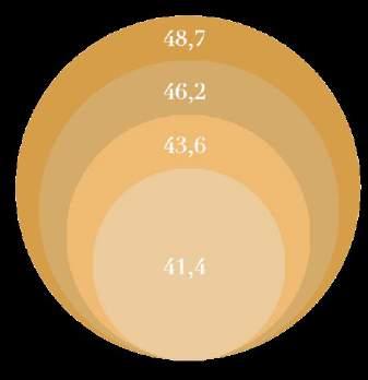
Reduction of utilized agricultural area in Lombardy between 1982 - 2010 (% of regional land area)
land conversion between the 1950s and 2000 (hectares consumed per day)


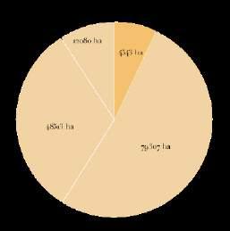


|8 ENVIRONMENTAL MOSAIC DATA Wilderness Agricultural landscape Urbanized Third landscape
DECREASE IN AGRICULTURAL SURFACE AREA
Lombardia Veneto Piemonte Emilia Romagna Sicilia Lazio 12,5 8,9 8,7 8 6,5 6
Urban
Crown system

Filament system
Branched system

PRIMORDIAL LANDSCAPE

|9
M’APPARE THE METROPOLITAN CITYNATURE AND ECOLOGY
Confinement elements that extend across macro areas creating a continuous and compact system.
Nature enters the area creating a linear system.
Nature is distributed in a network of corridors capable of attenuating urban development.


|10
Terzo paesaggio
agricola
La natura si concentra nei punti definiti ma fragili
La natura si concentra nei punti definiti ma fragili
Corona
Paesaggioproduttivo
Conversione urbana dei suoli tra gli anni il 2000 (ettari consumati al giorno)

principalimilanesi
corridoio ecologico
corridoio ecologico
La natura si distribuisce in una rete di corridoi in grado di attenuare lo sviluppo urbano.
Paesaggioproduttivo
Fasce di rispetto di arterie
La natura si distribuisce in una rete di corridoi in grado di attenuare lo sviluppo urbano.
Fasce di rispetto di arterie infrastrutturali
Paesaggioproduttivo
Infrastructural area bands
Spazi agricoli non insularizzati e in connessione diretta con gli spazi dell’aperta campagna
Spazi agricoli non insularizzati e in connessione diretta con gli spazi dell’aperta
Aree residuali, comprese nel corridoio di incompatibilità ambientale di grandi infrastrutture che generano pressioni ambientali e potenziali rischi
Frammenti all’intreno dei reticoli costruiti
Fragments within urban areas
pensiero di John Dixon Hunt)
Spazi agricoli non insularizzati e in connessione diretta con gli spazi dell’aperta campagna
Aree residuali, comprese nel corridoio di incompatibilità ambientale di grandi infrastrutture che generano pressioni ambientali e potenziali rischi

Sequenza di tessere agricole che si incuneano tra il costruito e che si connettono con gli spazi agricoli aperti e/o aree naturali come i
Sequenza di tessere agricole che si incuneano tra il costruito e che si connettono con gli spazi agricoli aperti e/o aree naturali come i boschi
- La rete ecologica della provincia di Milano : analisi e studi di settore per il progetto di Piano territoriale dinamento provinciale, Sergio Malcevschim Malcevschi, Sergio
PRODUCTIVE LANDSCAPE
- Il territorio che cambia : ambienti, paesaggi e immagini della regione milanese, Stefano Boeri, Arturo Lanzani, Edoardo Marini Boeri, Stefano Marini,
Frammenti residui compresi all’interno dei tessuti urbani reticolari fortemente disgregati
Sequenza di tessere agricole che si incuneano tra il costruito e che si connettono con gli spazi agricoli aperti e/o aree naturali come i
boschi
- La città compatta : sperimentazioni contemporanee sull’isolato urbano europeo, Luca Reale.
- Fuori città, senza campagna : paesaggio e progetto nella città diffusa, Luca Dal Pozzolo
della provincia di Milano : analisi e studi di settore per il progetto di Piano territoriale di coor-
Frammenti residui compresi all’interno dei tessuti urbani reticolari fortemente disgregati
|11
gili
Potenziale corridoio ecologico
Frammenti all’intreno dei reticoli
Fasce di rispetto di arterie infrastrutturali
, Sergio Malcevschim Malcevschi, Sergio
cambia : ambienti, paesaggi e immagini della regione milanese, Stefano Boeri, Arturo Lanzani,
Crown
M’APPARE THE METROPOLITAN CITYNATURE AND ECOLOGY
Confinement elements that extend across macro areas creating a continuous and compact system.

Nature enters the area creating a linear system.
Nature is distributed in a network of corridors capable of attenuating urban development.


|12
Primeval nature
Riparian formations


Naturalistic oases
Spontaneous landscape
Reforestation of abandoned areas

Abandoned agricultural areas
Productive landscape
Separating rows

Productive forest
The dispersed city


Forest park
Fragmentary forest
TERRITORIAL DIVERSITY
Place | Lombardia Scale 1:50000
Year 2012
TOOLS
|13
M’APPARE THE METROPOLITAN CITYNATURE AND ECOLOGY
With these two images we want to highlight a problem that is underestimated today. The decisive advance of the forest, over the years, has destabilized that band interposed between two elements that we call margin. Below are the growth indices of the phenomenon.

RESOURCE:
The use of the forest as a tool: riparian, regenerative, compensatory, definition of the perimeter margin for the expansion of the city. The enormous quantity of wood produced every year could be used on the market for the production of furniture, effectively reducing the wood imported from abroad.

AN UNSTABLE MARGIN
Place | Lombardia
Scale 1:550000
|14
Forest system in 1980
Forest system in 2016
Crown system (south)
Po (sud) - Scala 1:60.000


B C
C
C

ripariali
aree boschive urbanizzato pioppeti urbanizzato
agricolo pioppeti formazioni ripariali agricolo formazioni ripariali pioppeti agricolo formazioni ripariali
Bacino del Po (sud-ovest) - Scala 1:60.000 Bacino dell’Adda (sud-est) - Scala 1:60.000 Canali di irrigazione Campi agricoli Campi agricoli Bosco produttivo Bosco produttivo Percorso fluviale Campi agricoli Campi agricoli Bosco ripariale
urbanizzato esondazioni
Schemiesezionitipologichedellesviluppoterritoriale
Branched system (south-east)
Percorso fluviale Bosco produttivo Filari di separazione Bosco produttivo
Problematichedeipatchesesistenti
pioppeti agricolo
Assenza di filtro lungo le sponde del fiume.
M’APPARE THE METROPOLITAN CITYNATURE AND ECOLOGY
Conseguenza Aumento possibile mento delle agricole circostanti.
Creazione
soluzione:
Agricultural Poplar groves Riparian formations

olitecnico di Milano di Architettura e Società integrato di progettazione e rappresentazione urbanistica di progettazione urbana e forme del disegno urbanistico accademio 2016/2017
pioppeti
Bacino dell’Adda (sud-est) - Scala 1:60.000 pioppeti
Grandi aree insediative aperte.
Docenti: Emanuele Garda, Daniele Villa
Tutor: Giorgio Limonta, Stefano Saloriani
dell’Adda (sud-est)
Bacino dell’Adda (sud-est) - Scala 1:60.000 pioppeti
Presenza siva di produttive pioppicoltura).
Conseguenza: Aumento di un possibile inquinamento delle aree agricole circostanti.
Schemiesezionitipologichedellesviluppoterritoriale
Junior tutor: Virginia Vecchi
Studenti: Amelia Cimini, Benedetta Colafato, Michael Lombardini, Marcelo Suarez Salomè (gruppo 7)
Titolo: M’appare la Città Metropolitana - Natura ed ecologia


- Scala 1:60.000 Percorso fluviale produttivo di separazione agricoli Insediamenti agricoli agricoli Grandi infrastrutture agricoli Insediamenti intensivi agricoli intensivi problematiche agricolo formazioni ripariali pioppeti agricolo formazioni ripariali pioppeti sviluppoterritoriale D (sud-ovest) - Scala 1:60.000
soluzione:
|15
Risoluzione delle criticità
Bacino del Po (sud) - Scala 1:60.000
Urbanizzato Percorsi carrabili Bosco produttivo Canali di irrigazione Campi agricoli Campi agricoli Bosco produttivo Bosco produttivo Percorso fluviale Campi agricoli Campi agricoli Insediamenti agricoli Campi agricoli Percorso distributivo Insediamenti agricoli Aree boscate ripariali Percorso fluviale
e
Dati Dusaf 2012 Esondazioni Scala
Areeanalizzate
Bacino del Po (sud-ovest) - Scala 1:60.000
Fonti
riferimenti bibliografici -
1:550.000
Soluzioni Wilderness
Problematiche
Inquadramentodelleareeanalizzate Scala 1:550.000
aree
agricole
Bassa pianura
Alta pianura
Collina
Bassa pianura
Alta pianura
Collina Bassa pianura Schemiesezioni
Alta pianura A B A B
Collina C
agricolo pioppeti formazioni ripariali agricolo formazioni ripariali D
A B
C
D A B
C
D
A B C
A B C A B C
A B C A B C
Creazione di fasce arboree lungo le sponde del fiume. Fasce maggiori a 25 m secondo quanto delineato dalla RER.
Grandi aree diative aperte.
soluzione
Scala1:400.000
buffer divisori grado di un possibile namento.
RESOLUTION OF CRITICAL ISSUES IN THE PO BASIN Scale 1:60.000
Filament system (south-west)
Areeanalizzateconproblematiche
Soluzionideipatchesesistenti
Conseguenza: Aumento di rischio esondazioni.
Aree zate. soluzione
Conseguenza
dell’Adda (sud-est) - Scala 1:60.000
1:60.000 Areeanalizzateconproblematiche agricolo
Bacino dell’Adda (sud-est)
Bacino
- Scala
formazioni ripariali
Schemiesezionitipologichedellesviluppoterritoriale
(sud-ovest) - Scala 1:60.000
Areeanalizzateconproblematiche agricolo formazioni ripariali
formazioni
Areeanalizzateconproblematiche
formazioni ripariali
C
Schemiesezionitipologichedellesviluppoterritoriale
Assenza di filtro lungo le sponde del fiume.
Conseguenza: Aumento di rischio esondazioni.
Filari di separazione
Crown system (south)
Filament system (south-west)
Branched system (south-east)
Problematichedeipatchesesistenti
soluzione:
Creazione di fasce arboree lungo le sponde del fiume. Fasce maggiori a 25 m secondo quanto delineato dalla RER.
Grandi aree insediative aperte.
Conseguenza: Aumento di un possibile inquinamento delle aree agricole circostanti.
DIAGRAMS AND SECTION OF TERRITORIAL DEVELOPMENT
Soluzionideipatchesesistenti
Docenti: Emanuele Garda, Daniele Villa
Tutor: Giorgio Limonta, Stefano Saloriani
Junior tutor: Virginia Vecchi
soluzione:
rappresentazione urbanistica forme del disegno urbanistico
Creazione di fasce arboree lungo le sponde del fiume.
Presenza eccessiva di matrici produttive (es.
soluzione:
Studenti: Amelia Cimini, Benedetta Colafato, Michael Lombardini, Marcelo Suarez Salomè (gruppo 7)
Titolo: M’appare la Città Metropolitana - Natura ed ecologia
Creazione di buffer divisori in grado di limitare un possibile inqui-

Assenza di filtro lungo le barriere lineari.

|16
del Po (sud) - Scala 1:60.000 Bacino del Po (sud-ovest)Urbanizzato Percorsi carrabili Bosco produttivo Canali di irrigazione Campi agricoli Campi agricoli Bosco produttivo Bosco produttivo Percorso fluviale Campi agricoli Campi agricoli Insediamenti agricoli Campi agricoli Percorso distributivo
Bacino
aree boschive urbanizzato
aree agricole urbanizzato esondazioni Bassa pianura Alta pianura Collina Bassa pianura Alta pianura agricolo pioppeti formazioni ripariali A C D A C D A B C B B B
pioppeti urbanizzato
Assenza di filtro lungo le sponde del fiume.
Bacino del Po (sud-ovest) - Scala 1:60.000
Percorso fluviale Campi agricoli Campi agricoli Insediamenti agricoli Campi agricoli Percorso distributivo Insediamenti agricoli Aree boscate ripariali Percorso fluviale Campi coltivati Bosco produttivo Bosco ripariale Percorso fluviale Bosco produttivo
Bacino dell’Adda (sud-est) -
B C
agricolo pioppeti formazioni ripariali agricolo pioppeti
Schemiesezionitipologichedellesviluppoterritoriale
Fasce maggiori a 25
1:60.000
agricoli
agricoli
agricoli Grandi infrastrutture Campi agricoli Insediamenti intensivi Campi agricoli intensivi agricolo
pioppeti D
Campi
Insediamenti
Campi
formazioni ripariali
Absence of filter along the banks of the river.
Consequence Increased risk of flooding.
Solution
Creation of tree belts along the river banks. Bands greater than 25 m as outlined by the RER.
Large open settlement areas.
Consequence Increase in possible pollution of the surrounding agricultural areas.
Excessive presence of productive matrices (e.g. poplar cultivation)
Consequence
Underutilized areas.
Absence of filter along the linear barriers.

Consequence
Fragmentation of the territory.


REGENERATION INTERVENTIONS FORLANINI DISTRICT
|22
Additions
Parasitic elements that add volumes to the existing building
Saturation
Additions of buildings in vacant areas and dentification of buildings
|23 MECENATE DISTRICT INTERVENTION TOOLS
|24 MECENATE DISTRICT MASTERPLAM
|25
0.3
Adda-Martesana design explorations
A park city
The design path intends to offer a contribution to the theme of designing urban space and in particular open space, understood as a characterizing element of the territory.
Urban space refers to all the unbuilt territory in and around urban areas, which forms a connective network between internal urban areas and the surrounding territory. In this way the network acts as a binder and a skeleton that holds individual spaces together.
|26
The territory of the Municipality of Inzago develops in the Adda Martesana district. The landscape is mainly characterized by the presence of the Naviglio Martesana which divides the municipality into two parts and constitutes the most relevant environmental element. The agricultural areas represented here are assumed by the PTCP and subsequently by the PTRA as strategic agricultural areas, which have a landscape and environmental value.
PTRA - Regional Territorial Area Plan
Trying to make the “strategic vision” of general and sector planning coherent with the physical, environmental, economic and social context, whose strengths and weaknesses it analyses, the PTRA highlights potential and opportunities for local realities and for territorial systems.
The Municipalities of Martesana-Adda extend over a total area of 270 km2 which is equal to 13% of the entire Province of Milan. In this territory the population density is lower than the provincial average value. It is no coincidence that the open space, of which more than 2/3 is used for agricultural purposes, has a significant extension and is still a constitutive fact of the territory, especially of the southern portion and towards the Adda.


|27 MUNICIPAL DEVELOPMENT ALONG THE ADDA - MARTESANA SYSTEM Adda-Martesana design explorations | A park city
N
Agricultural areas

The municipal territory of Inzago is located for almost all of its surface within the “high eastern irrigated plain” and to a minimal extent in the high dry plain of Trezzo to the north. The presence of agricultural parcels is intended as a place to spend free time, in which elements such as industrial, logistical and commercial settlements are present.

|28 AGRICULTURAL AREAS AS A PROPOSAL FOR PLIS
N
Provincial road 180
Highway 10
Naviglio Martesana
The resulting fenced green spaces
The spaces of technological platforms

Commercial spaces
The production spaces
Green spaces for public use
|29 STRUCTURAL CHARACTERISTICS OF THE TERRITORY Adda-Martesana design explorations | A park city
Highway 10
Provincial road 180
The construction of the Naviglio Piccolo, which took place in just 3 years, originates from the Adda river and irrigates almost 25,000 hectares of land. The territory crossed by the Naviglio appears to be characterized by civilizations made of water and agricultural fields which are organized, for the most part, around ancient nuclei, crossing bridges, buildings of worship and farmhouses.
The Martesana, in addition to representing a resource for the surrounding area, also encounters critical aspects which, as regards the Municipality of Inzago, are highlighted in the eastern area, towards the Municipality of Cassano d’Adda.


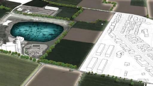
The two critical aspects, highlighted by the PTRA of the Navigli Lombardi, include the presence of a basin and the bridge.


The water system constitutes a precise structuring element of this area and, to a large extent, the “support and strength point” for the construction of a connection system capable of redesigning the ways in which urban spaces are used and the use of open spaces.The Naviglio della Martesana, in an east-west direction, characterized by a strong landscape-recreational value, takes on different characters and presents values and potential still to a large extent to be interpreted in the construction of a park-city gate.


|30 Dry situation
Flood situation Critical aspects of Naviglio
Martesana
1 2 Critical aspects
Buildings with 2-3 floors Buildings with 3-6 floors Buildings with 6-12 floors Crossing
THE BACKBONE OF THE WATERWAYS
Bicycle lane
1
Naviglio Martesana
The Municipality of Inzago is characterized by a high presence of agricultural fields which, thanks to their positioning, form a sort of greenwelt around the residential areas and industrial settlements. For this reason, the Inzaga area would be suitable for redefining the multiple existing inter-farm routes and strengthening the relationship between man-nature and city-countryside. Agricultural parcels could therefore become places where you can spend your free time, observe new landscapes and create new points of reference.
WEST:Existing inter-farm routes which present, in their current state, with a non-continuity of rows, presence of industrial settlements, high presence of agricultural fields and a lack of transversal crossings on the Naviglio della Martesana.
EAST:Consistent presence of buildings close to canals and/or agricultural fields. Possibility of creating new inter-farm routes through the pre-existence of naturally defined routes or through the use of connection bridges on the Naviglio della Martesana.


SOUTH:Existing inter-farm paths characterized by a good presence of tree-lined rows and agricultural fields. Possibility of creating reference points through the use of identifying elements also taking advantage of the proximity of the water park.
ROUTES:Redefinition of existing routes in such a way as to be able to limit settlement expansion through already existing interposition green areas (Cava Via Adige-PGT Forecast “Areas intended for greenery”, green area near residential areas) and agricultural parcels.

|31
Adda-Martesana design explorations | A park city AGROSYSTEMIC CROWN
The main objective is to enhance the existing inter-farm routes in the Inzaga area in order to establish an adequate balance between settlements, natural elements (Naviglio della Martesana - agricultural fields) and existing infrastructures.
Intervention criteria
Inverted T surgery
St1
Mitigation works to eliminate the barrier effect caused by the presence of infrastructures.
Linear intervention


St2
Interventions to enhance existing cycle-pedestrian paths through urban furnishing elements and redefinition of existing greenery.
Buffer band surgery
St3
Insertion of new buffer strips to visually and acoustically mitigate the areas adjacent to buildings.
Connection intervention
St4
Interventions that allow the connection of areas “separated” by natural and non-natural elements, through the use of small bridges.
Ex-quarry intervention
St5

Construction of a new slow road system through the use of existing inter-farm paths and with the insertion of new buffer strips.

Recovery surgery
St6
Interventions to redefine the present riparian vegetation and arrangement of the inter-farm path along the canal.

|32 STRATEGY GENERAL
POTENZIALITA’
Necessità di limitare e/o evitare il consumo di suolo tramite l’utilizzo di percorsi già definiti naturalmente
INTERVENTI
Sistemazione di elementi d’arredo lungo il percorso ciclo-pedonale e fascia di compensazione nelle vicinanze della zona industriale
POTENTIALITY
Need to limit and/or avoid land consumption through the use of already naturally defined routes


INTERVENTIONS
Arrangement of furnishing elements along the cycle-pedestrian path and compensation strip near the industrial area


|33 Adda-Martesana design explorations | A park city DESIGN HYPOTHESES
St3
Agricultural field Campo agricolo
St3
POTENZIALITA’
Recuperare un rapporto organico tra aree umide e sistema rurale presente sul territorio
INTERVENTI
Ridefinizione del percorso lungo il canale Crosina tramite l’utilizzo di materiali in corten e passerella aggettante a bordo canale St6
POTENTIALITY
Recover an organic relationship between wetlands and the rural system present in the area

INTERVENTIONS
Redefinition of the route along the Crosina canal through the use of corten materials and a walkway jutting out onto the canal edge


|34 DESIGN HYPOTHESES
St6
Crosina canel Canale Crosina
POTENTIALITY

Need to avoid land consumption and define a guideline within the green area located near the Naviglio della Martesana

INTERVENTIONS
Redefinition of an existing path through the use of a wooden walkway

|35 Adda-Martesana design explorations | A park city DESIGN HYPOTHESES
Agricultural field
The belief that underpinned the development of the proposed tool is that large urban redevelopments are social initiatives, even before building ones, being aimed at (re)constituting a missing vital fabric. This presupposes the targeted weighing of the structure of the functions to which the intervention is intended. In this direction, the implementation plan places the emphasis on the centrality of the new urban greenery and envisages including the possibility of creating and ensuring usability alongside the presence of quotas of free housing, subsidized housing and commercial quotas along the eastern and western edges.
|36
0.4
ATUab6 Implementation PlanMunicipality of Saronno
VIA PADRE GIULIANI
lemento ferroviario occidentale
A tal proposito ficato sia decisamente del comune al 13%.
Proprio per disponibilità agricole situate La recente sione industriale modo tale della città. In questa direzione aree/ nuovi futuro assetto di riconversione.
Trasporto urbano - linea 4 ciclabile
AMBIENTE
Fratelli Cervi street
verde pubblico
attrezzature sportive
Balasso street Luigi Sampietro street
SERVIZI
scuola primaria
edilizia sociale
attrezzature servizi sociali
attrezzature religiose
Street front elevation Scale 1:1000
altri servizi (es.autofficina)
parcheggi
L’area
risulta essere situata all’interno del quartiere Matteotti.
Tale quartiere fu intitolato così per il fratello di Arnaldo Mussolini e il primo nucleo abitativo prevedeva circa 85 abitazioni destinate ad accogliere i lavoratori dell’Isotta Fraschina.
Infine la sua costruzione ebbe inizio a partire dalla fine degli anni ‘30 ma fu rallentata a causa della guerra.
|37 ANTONIO PARMA Il Comune di Milano,
ATU ab 6_ Ex Pozzi-Ginori,
Via Balasso - fronte commerciale
STAZIONE SARONNO NORD
ATUab 6 “Ex Pozzi Ginori
ATUab 4
ATUb 5 (Via Sampietro)
SN073
SN081
SN071
SN074
SN080
SN078
SN083
RELAZIONE INQUADRAMENTO PERCORSO TRASPORTO URBANO
ATUab6 Implementation Plan
N
Transversal settlement principle
Perimeter construction along the edges
- Ensure optical cones towards the park
- Commercial fronts along public areas
Pedestrian routes


-Perimeter construction along the edges
- Ensure optical cones towards the park


- Commercial fronts along public areas
- Setback of residential buildings along public areas


-Perimeter construction along the edges
-Commercial fronts along public areas
- Open perimeter capable of connect the park and the commercial fronts

|38 CONCEPT LAYERING
East-west infiltration green open spaces
Environmental islands of publicprivate relations


|39 ATUab6 Implementation Plan GENERAL PLAN, VOLUMETRIC AND SECTIONS
Place | Saronno
N
Scale 1:500
Scale 1:500
0.5
Spatial tangrams.
Rethinking urban voids with equally decomposable models
For several years, the different forms of public space have been constantly linked to the countless transformations of the contemporary city and the needs of the individual himself.
The succession of metamorphoses also generate urban fragments that are forgotten and in a state of complete abandonment. However, such particles could have the ability to stitch together some parts of the city. It is thus that urban voids could be labeled as ‘pre-established places’ for abandonment and in which the actors have difficulty reconverting them into spaces of social appropriation. The paper therefore proposes a rereading of the ‘Estonoesunsolar’ project, started in 2009 in the city of Zaragoza, which aims to enhance urban voids , according to a principle of temporary reuse of spaces in a state of degradation and actions of reconversion of vacant lots into places of social inclusion. The contribution is therefore based on rethinking these gaps, through the creation of ‘spatial Tangrams’ which take the characteristics of the Chinese puzzle as a basic ‘rule’, demonstrating how choices can be defined within an urban space that thanks to meticulous or apparently impossible actions, they form a multiplicity of ‘equidecomposable’ micro cores.
|40
The study and analysis of the ‘solares vacíos’, i.e. the residual voids, which are found above all in the histo

ric center and in the San Pablo district of the city of Zaragoza has allowed a strong condition of degradation to emerge.
A problem that could see, in the implementation of new strategies, a reactivation of urban voids and the relational fabric by trying to question the forms of these places, the repetitions, the details and the present waste.


|41
-
Spatial tangrams OVERALL PICTURE: URBAN VOIDS AND REGENERATED SPACES N 0.1 In-fill voids 0.2 Specular voids 0.3 Isolated voids 0.4 Urban voids
San Pablo street Miguel de Ara street
Street of the Preachers
Pasco Enchegaray and Caballero
The basic model that is painted on the surface of the site is composed of a square with seven geometric shapes inside (5 triangles, 1 square and 1 parallelogram) capable of accommodating different functions, needs and choices of users during the visit. span of the day.


A grid whose sole rule is the size of the areas and which allows the spatial Tangrams to develop micro-cores in which it is possible to modulate play, rest, smart working and training areas and host events of all kinds. A vast collection of areas that follow four functional and organizational models.

Area formed by all seven geometric figures of the Tangram and in which it is possible to freely position any type of urban furniture created; or it can also be used as a fruition piece.
Area of free composition and intended to host creations including: flower holders, objects with recycled material, etc
Area characterized by a green heart capable of creating privacy and relaxation boundaries and which provides the possibility of placing street furniture at both ends.

Space used for playing and where it is possible to find a box filled with sand which allows you to have a sensorial experience and encourage social interactions.
A space that recalls the installation ‘The Dream City’, created by Adam Kalinowski in 2015 in the city of Pearl, Doha Qatar.
|42 SPATIAL TANGRAMS AND FUNCTIONAL MODULES


|43 Spatial tangrams SPATIAL TANGRAMS - FUNCTIONAL SUBDIVISION


|44 ELEVATIONS Spatial tangrams
Models


|45
Bachelor’s Thesis
AMELIA CIMINI | QRCODE
Repertoire part.1
QR CODE


