ECOLOGICAL URBAN STUDY OF THE NORTHERN RIDGE STUDIO II PROJECT REPORT
Batch of 2020- 2022, M.Arch, Jamia Millia Islamia University, New Delhi


Batch of 2020- 2022, M.Arch, Jamia Millia Islamia University, New Delhi

AIM:
Regeneration of underutilized eco-sensitive zone through recreation as a catalyst by enhancement of happiness index and ecology.
Kamla Nehru Ridge is the northern extension of the Aravalli ranges. It’s high terrain between River Yamuna and the Najafgarh Drain, than the surrounding areas with lower elevations is a key factor on the topography map of Delhi. Ridge provides useful ecosystem services to Delhi. It contributes 87 native plant species, 7 mammal species & 31 butterfly species among many others. It has a number of water bodies like Khooni Jheel which also has a historical influence. The Ridge is known for its historical heritage as it was a prominent place in the Mughal Dynasty as well as during the British Colonization. Also, the context of the selected site is rich in cultural and ethnic groups like the Punjabi Basti, Madrasi Colony, etc. The site thus, has a lot of opportunities for recreation to cater to the neighboring settlements. The Ridge is the only Urban Green Space in the entire Northern part of Delhi, hence the preservation of the Ridge in the city-level is also essential.

Compilation and analysis of primary data on ridges & arvali ranges. Through research papers, books, articles and news columns.
Understanding the analytical structure and parameters of the happiness index through case study of Bhutan. Developing a better understanding of happiness index through various studies, report (World happiness index report) and books such as Happy cities.
Topography- the layers will consist of soil type & contour of Delhi Hydrology- the layers will consist of all the water systems of delhi. Vegetation- this layer includes reserved forests, green belts & biodiversity parks. Open Spaces- the layer will be composed of green, blue and brown open spaces.
Following our research into various eco sensitive zones, we identified two that we would like to study further for studio to look at it from recreational aspect.
Following the site’s rationale, we’ll dig further into key parameters to better explain the site’s current state, issues, historical context and evolution.
Understanding the role of various urban systems and ecological layers and their inter relation which gives the ridge a distinctive form. Ecological layer (Micro level)- mapping different ecological layers such as contours to understand the topography of the site and the drainage pattern, vegetation density, vegetation, flora & fauna. Built- Unbuilt, Land use, Water Bodies, Heritage mapping,Scenic value mapping, Green open spaces, Activity mapping, Issues at site & policies.
Identifying the stakeholders
Residents, site users, MCD, forest department, DDA. Formulating a survey keeping in mind all the parameters of happiness index.
Overlapping various layers to get inference. Synthesis of Recreational Suitability, Identifying the opportunities and constraints.
Formulating design interventions and policies.
After analyzing the site and existing policies proposing amendment of the existing policies & proposing new policies
A compiled map of all the ecological layers of Delhi. Formulating theoretical framework for happiness index. Understanding parameter of happiness index, to include them in our study and look at the selected site under the same perspective. Identification of focus area and stretch, Kamla Nehru Ridge
Output Mapping
Data sets and preliminary data on happiness index. Parameters for analysis.Analysis of site. Identification of issues and challenges. Identification of proposal and intervention area.
Formulating a structure plan with the help of all the inferences obtained from happiness index, analysis and survey, to come up with strategies and zones for areas which have potential for recreation.
Coming up with design strategies and interventions appropriate for site and context
Output Policies, proposals and interventions.
The study shows the intervention when done in context of urban forests can improve the well-being of the people living around it and also increase the happiness index of the area. The study not only identifies the importance of such ecologically rich areas but also provides an insight on how they can be linked to the happiness quotient.
The term ‘Gross National Happiness’ was coined by Bhutan, that laid foundation to World Happiness Index.
1972- 4th King, Jigme Singye Wangchuck introduced GNH as a holistic, balanced approach to progressive material and spiritual development – Gross National Happiness is more important than Gross Domestic Product.
2008- Bhutan embraced democracy and the Constitution ensured the inclusion and continuity of GNH values.
2011- UN Assembly decided on following Bhutan example and passed the resolution ‘Happiness: towards a holistic approach to development’.
2012- Bhutan PM and UN Secretary-General called for High Level Meeting: Well-being and Happiness: Defining a New Economic Paradigm to encourage the spread of Bhutan’s GNH philosophy. The result was the first World Happiness Index and March 20 was declared International Happiness Day.
Over the years GNH has evolved from a noble aspiration into a more quantifiable tool, partly in response to the unexpected global attention it has garnered.
Bhutan has one of the stable ecosystems in the world and has virtually no environmental damage due to its long isolation. The restrictions on tourism and their protection of natural resources have let Bhutan preserve the beautiful landscape and the physical country as well as their cultural identity.
Today, it is technically defined as a ‘multi-dimensional development approach seeking to achieve a harmonious balance between material well-being and the spiritual, emotional and cultural needs of society’. The keywords being harmonious balance that may be achieved by balancing the needs of the body with those of the mind.
SOURCE: http://www.gnhcentrebhutan.org/what-is-gnh/history-of-gnh/
- Bhutan’s ancient legal code of 1629

The World Happiness report is an annual independent survey that evaluates global happiness in 156 countries. The United Nations Sustainable Development Solutions Network sponsors it.
The survey is based on how happy people perceive themselves to be. The report says the ‘science of happiness’ reviews evidence on the impact of various well-being measures on a population’s quality of life.
Each year, it looks at different indicators of a population’s well-being and works towards-
1. Setting an alternative framework of development,
2. Providing indicators to sectors to guide development (e.g electricity),
3. Allocating resources in accordance with targets and GNH screening tools,
4. Measuring people’s happiness and well being,
5. Measuring progress over time, an
6. Comparing progress across the country.
The first all India Happiness Report 2020 covering all States and Union Territories measuring happiness across the country, what contributes to people’s happiness, the impact of COVID-19 on happiness, and insights from thought leaders.
The report looks at six key variables to come to a happiness score.
If the government cannot create happiness for its people, then there is no purpose for government to exist.

The Happiness Index is a comprehensive survey instrument that assesses happiness, wellbeing, and aspects of sustainability and resilience. This instrument can be used to measure satisfaction with life and the conditions of life. It can also be used to define income inequality, trust in government, sense of community, and other aspects of wellbeing within specific demographics of a population
The GNHI works along four pillars, namely Good Governance, Sustainable Socio-Economic Development, Cultural Preservation, and Environmental Conservation.
These pillars are further classified into nine domains Good Governance, Living Standards, Education, Health, Cultural Diversity and Resilience, Ecological Deiversity and Resilience and Community Vitality.


Finland has topped the list for the fourth year in a row, followed by Denmark. Switzerland and Iceland. Clearly, the Nordic countries are the happiest countries in the world.
India ranks 144 among a total of 153 countries, according to WHR 2020 with a score of 3.5
The change in Happiness from 2008–2012 to 2017–2019 is in the negative by 1.216.
India has become one of the 5 countries with the largest drop since 20082012. With close to a fifth of global population, the country saw a large and a steady 1.2 point decline. India is now a new entrant to the bottom-ten group.
The National Capital of India, New Delhi comes seventh in the bottom ten, according to how positively their inhabitants evaluate their current lives. The change between 2005-2013 and 2014-2018 in New Delhi is in the negative by 1.022. This score stands the capital city fifth from the bottom.
GOOD GOVERNANCE: trust in government, sense of corruption, and competency.
LIVING STANDARDS: financial security and meeting basic needs.
EDUCATION: Knowledge, values, skills and formal and informal education across age levels.
TIME-USE: harmonious work and life balance with a sense of enjoyment and leisure.
CULTURAL DIVERSITY & RESILIENCE: strength and diversity of cultural norms, ethos and festivals across the country and age groups.
COMMUNITY VITALITY: sense of belonging, volunteerism, and sense of safety.


HEALTH: energy level and ability to perform everyday activities.


PSYCHOLOGICAL WELL-BEING: optimism, senses of purpose and of accomplishment.
ECOLOGICAL DIVERSITY & RESILIENCE: access to nature, pollution, and conservation.
This report aims to study the happiness index along the lines of recreation. Hence, these five domains will be mainly considered with the progress of the report.
The report was compiled considering six components:
• work and related issues such asearning and growth;

• relationships including family and friends;
• health including physical and mental;
• philanthropy including social concerns;
• religious or/and spiritual orientation; and

• the impact of COVID-19 on happiness.
Mizoram ranked first in IHR 2020, followed by Punjab and Andaman & Nicobar Islands. While Odisha, Uttarakhand, and Chhattisgarh ranked as the bottom three.
Among the big states, Punjab, Gujarat, and Telangana are among the top three states in happiness rankings.
Among smaller states, Mizoram, Sikkim, and Arunachal Pradesh are the top three states in happiness rankings.
Among union territories, Andaman and Nicobar Islands, Puducherry, and Lakshadweep are the top three in happiness rankings.
Maharashtra, Delhi, and Haryana have shown the worst possible impact of COVID-19 on happiness whereas Puducherry and Jammu and Kashmir are neutral and Manipur, Andaman and Nicobar Islands and Lakshadweep have shown the best possible impact.
Instilling the spirit of generosity and voluntary social service through formation of self service groups and communities.
making environmental concerns a priority by promoting sustainable development at all levels.
developing a trustworthy social support system where each citizen has a moral responsibility.


Nordic countries rank so high on the World happiness Index because they have free education and healthcare, low crime rates, generous social security nets, a generally homogeneous population, and are fairly rich.
There’s high quality free healthcare and education. There’s ample parental leave, and labor market models that protect against a lot of anxiety around jobs and job loss. India is one of five countries with the largest decline in happiness in the last decade. The reason is a combination of social, political, and economic stresses.
Delhi is one of the most affected state during the spread of SARS-CoV-2 virus in 2020, showing the worst possible impact among others like Maharashtra and Haryana. However, the capital city placed top among the Northern states of the country in the happiness rankings.
Mizoram is the happiest state in the country. The north-eastern state has topped the India Happiness Report. Key factors what makes Mizoram the happiest state:
• A Deep Sense Of Care About Others
• Belief In Nature
• Honesty
• Preservation Of Their Culture
• The Zawlbuk Tradition
1. Glaring disparity in the purchasing power of the population
2. Shortfall in public infrastructure for education
3. Safety and security of women
4. Perception of personal liberties

5. Poor Mental Health
6. Rapid urbanisation and congestion in cities
7. Environmental pollution and problems
restoring faith in government through transparency and instituitional integrity.
Despite being a fast growing country, it has high levels of economic inequalities. India’s richest 1 % has almost 73 % of the total wealth created in the economy. Managing big cash flows in a sustainable and transparent manner is difficult in India. This has eventually led to corruption, scam, etc. at the higher levels. This has led to the drop in India’s rank even in the latest global corruption perception index.
In the Quality of Life Index 2021 by Numbeo, India ranks 63rd in the world and 17th in the continent. Factors like the cost of living and purchasing power, affordabile housing, pollution in air, water, etc., crime rates, health system and traffic systems are considered.
Health-wise, India has a low average life expectancy rate (69 years) than the world life expectancy average of 74 years. India ranks 15 in Asia and 42nd in the world as per Health Care Index of 2021.
For a society to flourish with cultural and communal trusts, it should be free of crime and the fear of it. Crime-wise, India ranks 67th in the world and 16th in Asia. The factors considered are the statistics on the levels of crime, change of crime levels in the past years and other inferences on safety as percieved by people.
To calculate the Pollution Index, indicators like air quality, drinking water quality and accessibility, water pollution, garbage disposal patterns, noise and light after sunset hours, number of green and open spaces, etc. were taken into account and India was found to rank 15th in the world and 9th in Asia.
working towards a more equitable society against discrimination and social evil.
enhancement of public spending on health and medical infrastructure.
• Meet the economical needs of the people with the ongoing rapid urbanizing in cities.
•
• Check on the availability of food and water and its quality all over the country.
•
• Make quality healthcare within the budget of the every citizen.
•
• Scrutinize the safety of people of all genders and beliefs, children, people with disabilities, etc. without dircrimination.
•
• Review and reduce the pollution and degradation in the land, water and environment.
Based on the geology and the geomorphology, the region of the city of Delhi can be broadly divided into four parts - Kohi (hills) which comprises the hills of Aravalli, Bangar (main land), Khadar (sandy alluvium) along the river Yamuna and Dabar (low lying area/ flood plains).
Leaving the hills and the plains, the river abandoned its original course and urban development in the 19th and 20th century gradually pushed it eastwards on to the lowest elevation leaving behind six old courses in the region.

Spurs of Aravalli (known as Ridge in Delhi)—the oldest fold mountains in India—and river Yamuna—a tributary of river Ganga—are two natural features which frame the triangular alluvial region. While there was a scattering of settlements in the region, the urban settlements of Delhi developed, more profoundly, around the eleventh century on the Aravalli Ridge to the south of the alluvial plain.
A spur of the Aravalli hills enter the Delhi region from present-day Gurugram in the south, and continue northwards, descending gradually towards the north east side, ending in Wazirabad near the river. The vegetation of Ridge comprises dry and deciduous trees which have adapted to the shallow soil and limited water. Some parts of the Ridge on the southern side have deep alluvial basins where there is a change in vegetation. The land flanking the river has sandy and coarse soils with shallow ground water table while the south western side is low lying. The composite climate of the region is characterized by a dry and hot summer (March to June) and a dry cold winter (October to February) interspersed by a brief monsoon period.
The city of Delhi is situated at a mean 225 m above sea level. Delhi’s terrain is affected by two major geographical elements: the Aravalli Ranges and the Yamuna River Plain. These also contain the highest and the lowest point of the city.
The hydrogeological set-up and the groundwater occurrence are further influenced by the four distinct physiographic units: (i) alluvial plain on the eastern and western sides of the ridge; (ii) Yamuna flood plain deposits; (iii) isolated and nearly closed Chattarpur alluvial basin; and (iv) NNE–SSW-trending quartzitic ridge.
Ht. above sea level Location Co-ordinates Land-use


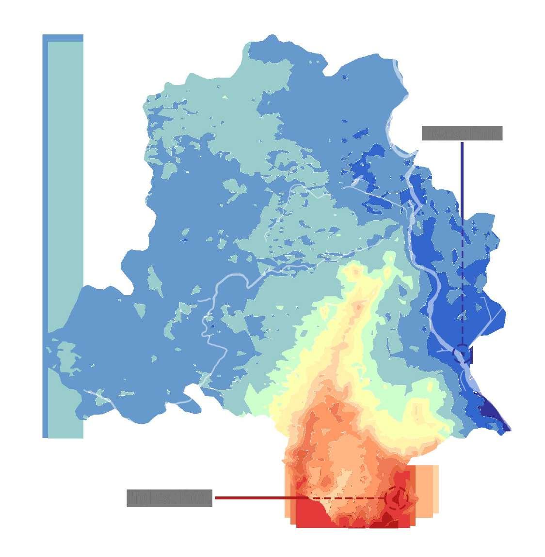
Highest Point 318 m In Asola-Bhatti Wildlife Sanctualry, Southern Bhatti Kalan District 28°26’27”N, 77°13’29”E Recreational- Regional Parks
Lowest Point 192 m In River Yamuna, near Kalindi Kunj Bridge, South-East Delhi A point inside the river River
The city lies on the Great Indian Plains on the bigger picture and hence has Alluvial Soil. The soil types mentioned below are on the basis of the mineral compositions found locally.

The terrain of Delhi is flat in general except for the NNE–SSW trending elevated ridge, which is an extension of the Aravalli hill and buried under the Yamuna alluvium in the northern parts of Delhi. River Yamuna is another prominent feature of Delhi, enters the city from north and flows southward with an eastern bend near Okhla.
Type Texture Percentage Location


Ridge Rocky 4% Aravalli Ranges, mainly in Asola-Bhatti region. Degradation due to quarrying and encroachment.

Kohi Silty clay/ Loamy 15% Foothills of Aravalli Ranges. Uneven topography leads to erosion

Bhangar Old Alluvium 41% Alipur, Shera, Narela, Ladpur, Najafgarh. Generally fertile with high moisture content.
Khadar New Alluvium 18% Along the River Plain in Balla, Shahdara, Gokalpur, Madanpur. Recent flood plain.
Dabar Saline Alkali 22% Low-lying areas in Najafagarh, Palam, Ladpur Shikharpur. Poor drainage affects the soil texture.

River Yamuna is the main water source. It enters Delhi at Palla village from the North and travels 32 km before leaving Delhi at the Jaitpur village in South. At present more than 20 drains pour into the river, mainly, Najafgarh, Shahdara and Barapullah Drain.

The NCT of Delhi continues to grow at a phenomenal rate and the ‘Delhi stretch’ remains worst polluted among all stretches. At the same time, the growth of the NCT of Delhi is now consuming the Yamuna River floodplain and transforming the riverfront at a much faster pace than ever before.
There are 969 water bodies in Delhi. These come under various jurisdictions like DDA, Archaelogical Survey Dept., Forest Dept., CPWD, MCD, Revenue/ Irrigation and Flood Control Dept., IIT, etc. Currently, 346 of them are dried up, garbage dumped in 81, 214 encroached with construction,etc. and 89 of them converted into parks. So only 239 of them remain as clean water bodies.


District-wise classification of the water bodies:
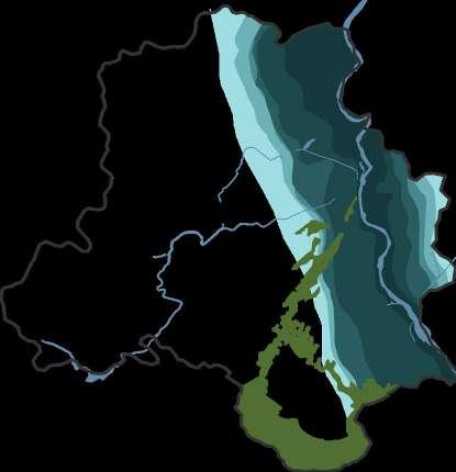


Delhi is typical Northern Tropical Thorn Forest Type seen in arid-semi arid zone.
District-wise classification of the forest cover:
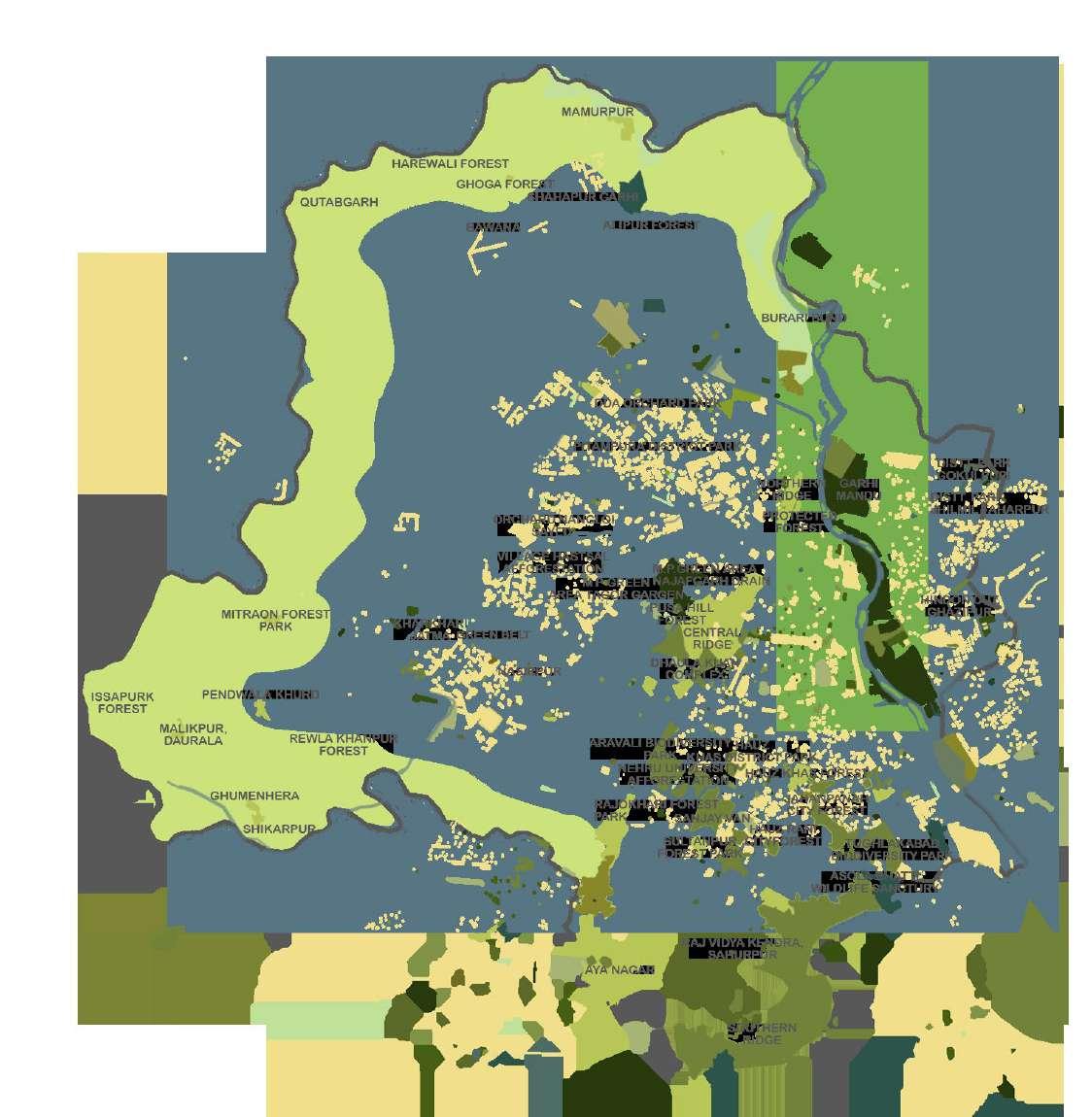


The total recorded forest area in Delhi is 85 sq. km. i.e. 5.73% of the geographic area of which the Reserved and Protected Forests constitute 91.76% and 8.24% of the total forest area respectively.


The ecological layers of Delhi are the representation of the rich and varied history the city has in its possession. Urban Delhi includes swathes of semi-wild places at its edge, shades off into wasteland or agricultural fields which support characteristic trees too. Delhi’s natural vegetation is sometimes called a ‘thorn forest’. which forms a transition zone where dry deciduous forest shades into desert scrub. The ridge and the river yamuna play a significant role in the generation of these various layers of ecology.
There are alot of artificial water systems created in the various historical cities of Delhi. The baolis, the kunds and the lakes are some examples.
The ridge is located in a high contour level area. The Kohi soil can be observed to mark the foothills of the Aravalli Ranges.Along the banks of Najafgarh Drain, we can observe dabar soil lines it.The bhangar and khadar soil are more fertile, with the new alluvium soil along the River Yamuna and Bhangar forming the base ground for other canals, therefore the presence of agricultural land. Agricultural ground on the periphery is due to the presence of fertile soil khadar.

Northern Ridge
Central Ridge
South Central Ridge
Southern Ridge

Aravalli Biodiversity Park, Asola Wildlife Sanctuary,Barapullah Drain,Bhalswa Lake,Burari Drain,Hari Nagar Lake Hauz Khas Lake, Najafgarh Drain, Okhla Bird Sanctuary, Paschim Vihar Lake, Purana Qila Lake, Sanjay Lake,Shamsi Talab, Tughluqabad Biodiversity Park, Yamuna Biodiversity Park.
Many parts of the forest area are barren landscape devoid of any dense vegetation due to extensive quarrying activities that have now been banned. In addition to these, there are few patches of protected forests in the city Rajokri, Mitraon, Mukhmel Pur, Ghumenhera and Bawana. Many of the forested areas in the suburbs have been converted into agricultural fields. The catchment area is observed in the banks of River Yamuna. There are mainly two catchment areas. One, where the Najafgarh Drain flows into the River, and the other where Barapullah Drain and Shahdara Drain flows into the River.
A distinctive feature of the distribution of open space in the city is that a variety of major open spaces occupy an extensive area at the centre of the city, representing its natural, ceremonial and recreational character. Dense vegetation of trees along the roads with extensive open spaces creates an environment friendly microclimate that gives the area a distinct identity.
Delhi a city full of poetry, playing its part as an ancient and historic city of India, located in a cusp formed by the tail end of the Aravali Mountain Range which culminates at the river Yamuna. The ridge is the elevated geological feature of Delhi which is the northern most extension of the old Aravalli ranges.
The Delhi Ridge stretches over a distance of 35 km, from Bhatti Mines to southeast of the 700 year old Tughlaqabad, branching in different directions, and finally tapering towards the northern end near Wazirabad on the western banks of Yamuna river. The ridge plays a very important role in Delhi’s history. Ridge constitutes of quartzite rocks, archaeologists have traced back to Stone Age finding traces of factories.
The topographic feature of the ridge attracted a lot of settlers for thousands of years. Much of the capitals greatest historical architecture are found in or around the ridge, ranging from 8th century Lal Kot fort, 12th century Qutub Minar, 17 th century walled city and lutyens 20 th century Delhi.
Delhi has witnessed the rise and fall of seven cities out of which four cities were located directly on the ridge for ecological reason as well for military security provided by the hills. The first significant event of the first war of independence of 1857, was also seen around the ridge. The British troops stationed themselves on the northern ridge to take the advantage of its height.

Over the years ridge has undergone constant pressure of population explosion, excessive resource extraction, construction of landscaped public parks, public housing, dumping of construction waste, etc. causing the shrinkage of the ridge.
The Ridges cover a distance of 35 km and is the Northern tip of the Aravalli Ranges that mainly occupy Rajasthan.
NORTHERN RIDGE OR KAMALA NEHRU RIDGE:
Hilly area near the Delhi University. It was declared a Reserve Forest in 1915. It initially covered an area of 170 hectares but have now shrunk to 87 hectares.
CENTRAL RIDGE OR NEW DELHI RIDGE:
Located in the heart of Delhi, it was declared a Reserve Forest in 1914. It covers an area of 864 hectares.
SOUTH CENTRAL RIDGE OR MEHRAULI RIDGE:
Located near Jawaharlal Nehru University and centred round Sanjay Van, it covers an area of 633 hectares.
SOUTHERN RIDGE OR TUGHLAQABAD RIDGE:
Covers an area of 6200 hectares and includes the Asola Bhatti Wildlife Sanctaury.
SOURCE: https://rangandatta.wordpress.com/2017/06/29/historic-trail-along-north-ridge-kamala-nehru-ridge-delhi/
The Delhi Ridge is the vernacular name given to the Northern extension of the Aravalli Range as it passes through the Delhi megacity. The Ridge plays a vital role in maintaining salubrious environment in Delhi by acting as a barrier against the hot winds coming from Rajasthan.
It also provides critical ecosystem services such as recharging the ground water, absorbing air pollution, purifying the air, providing habitat for urban biodiversity and giving Delhi a ‘sense of place’ as well as aesthetic beauty.
It is interesting to note that the air quality in Delhi has simultaneously degraded in the same time period. While the degradation of air quality in Delhi may not be a direct result of the degradation of the Delhi Ridge, it is certain that the protection of the Ridge is certainly a pre-requisite for ensuring clean air in Delhi. The Delhi Ridge therefore needs to be conserved and maintained in order to ensure the environmental health of Delhi.


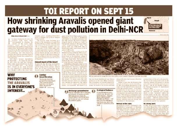

Nature holds the key to our aesthetic, intellectual, cognitive and even spiritual satisfaction.

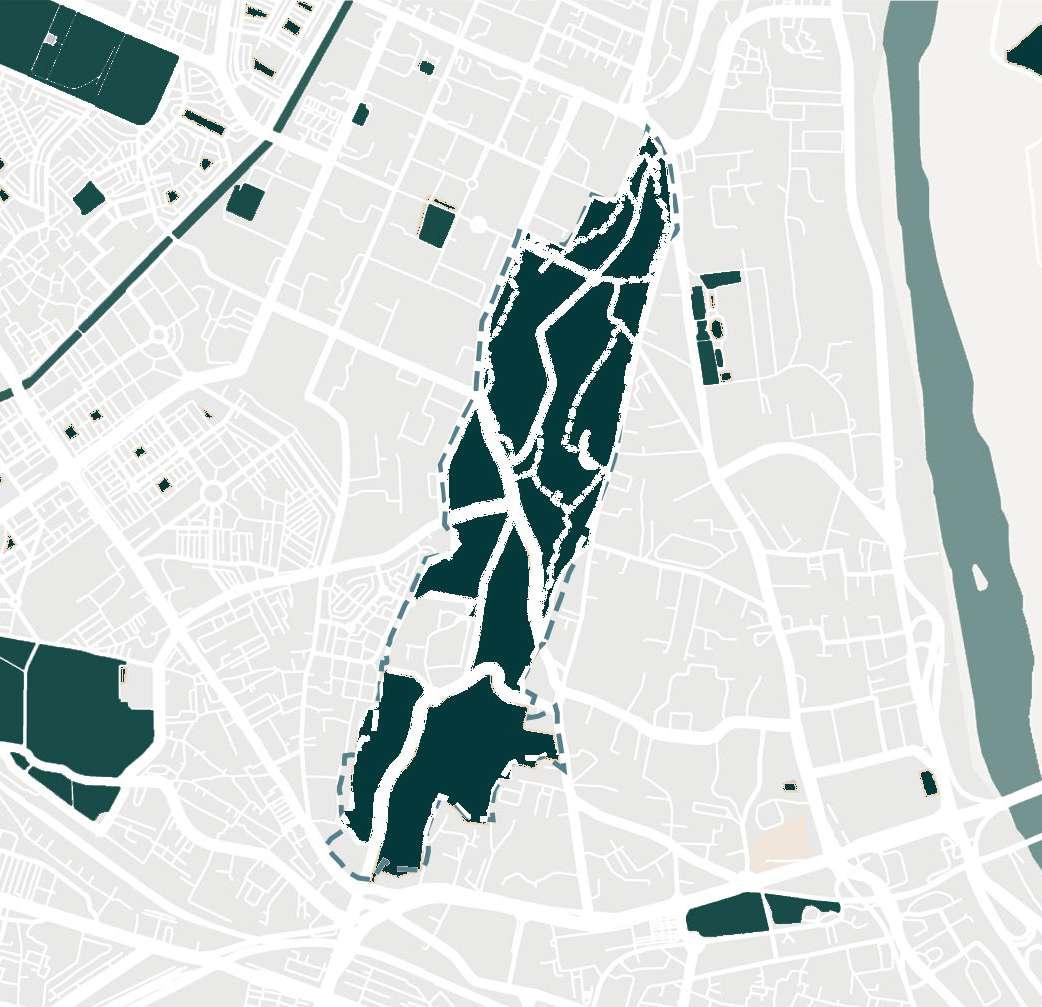
The North Delhi Ridge, often called the Old Delhi Ridge is of considerable significance with respect to the history of Delhi. It also goes by the name Kamla Nehru Ridge (named after the freedom fighter and the wife of Jawahar Lal Nehru) and is the smallest among the four parts the Delhi Ridge.


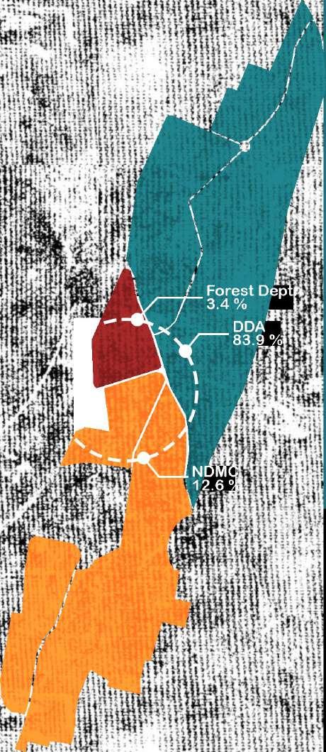
The Ridge occupies 87 ha area and constitutes 1.13 % portion of total Delhi Ridge area. There is, however, an ambiguity on the area as the Survey of India had previously reported it to be 82 ha.
There are three agencies managing the ridge,DDA manages 73 ha, NDMC (North Delhi Municipal Corporation) manages 11 ha and the Forest
Inhabitation and construction on the ridge started during the Tuglaq time. The oldest structure present here is attributed to the reign of Ferozshah Tughlaq. He had also made attempts to carry out afforestation activity in the Northern ridge in while using it as a hunting reserve, Kushak-i-Shikar, as it was in the outskirts of his fort-city Firoz Shah Kotla.
The ridge was later occupied by the Mughals, who were into massive deforestation, to develop Baghs and garden building projects like the Qudsia Bagh. They had set their forts around the same regionShahjahanabad and Red Fort, and also the Salim Shah Suri’s Fort- Salimgarh Fort, later used as a prison.

The British under EIC, who defeated the Mughals had reigned the area dotting it with ammunition stores, guard houses, signal towers, etc. like the Flagstaff Tower with vigorous deforestation. After 1857’s revolt, more memorials and cenotaphs like the Mutiny Memorial, were constructed.
In a megacity like Delhi the ridge plays a major role in preventing the destructive impacts of air pollution in Delhi to the greatest possible extent. The ecosystem ser vices tendered by the Ridge can be:
• Provisioning Services of goods of direct monetary value to the people. These are of immediate benefit to communities living on the fringes of the ridge or for those who are en croaching
Department under Delhi Government manages 3 ha.
The North Delhi Ridge is a declared Reserved Forest under Section 4 of Indian Forest Act, 1927, as on May 24th, 1994.


The ridge was earlier a continuous part of the Delhi Ridge. NDR is mainly quartzite bed rock with rocky outcrop on the surface. The Ridge has now separated from the main Ridge because of mining activities and tectonic movements.
• Regulating ser vices: the range of functions performed by the ecosystem, not defined in monetary terms but are of great value. E.g.: erosion, purifies the polluted air, regulates rainfall and recharges the depleting ground water resource.
• Cultural services: the needs of society or are understood for the aesthetic benefits. The ridge is an ideal spot for birding, photography, morning walks, etc.
• Supporting services: for provision of all other services and are crucial for the functioning of the ecosystem. Soil formation, process of plant growth, habitat for species, nutrient cycling, primary pr oductivity, etc. are some of the supporting services provided by the ridge.
The ridge is located at the fork where Najafgarh Drain meets the River Yamuna

The urban forest is surrounded by various refugee colnies like the Punjabi Bagh, Kabir Basti, Majnu ka Tila, etc. Some of these later developed into wealthier colonies with different cultural identities.

Today’s Civil Lines housed the British Cantonment, and is now one of the posh colonies of Delhi. The area around was an administrative hub with Old Secretariat, now Vidhan Sabha, the State Legislative Assembly and the University of Delhi Secretriat was the Vice Regal Lodge earlier.
Next to the University is the Kamla Nagar Market, one of the cheapest flea markets in Delhi. Its location and context makes it widely known among the young generation as a means of recreation. It is a part of the Kamla Nagar residential colony, which was a centre of political activity during the late British Rule and the first two decades post Independence. It was also a cultural hub as Gulzar, Santosh Anand and Manoj Kumar were active here before becoming popular in Bollywood. It was also a training base for wrestlers like Dara Singh, Guru Hanuman, Satpal Singh, Bhupendra Dhawan and Maha Singh Rao.


The Ridge has been the topographic feature that attracted settlers to the area for thousands of years. From the eighth-century Lal Kot fort and 12th century Qutub Minar, to Shah Jahan’s 17th century walled city and Lutyens’ 20th century Delhi, much of the Capital’s historical architecture is found in and around the Ridge. In the 14th century, the Ridge forest was covered with thorny scrubs with very little green cover. In the early 1900s, the British began restoring some of the Mughal gardens, and when their Imperial capital shifted from Calcutta (now Kolkata) to Delhi.
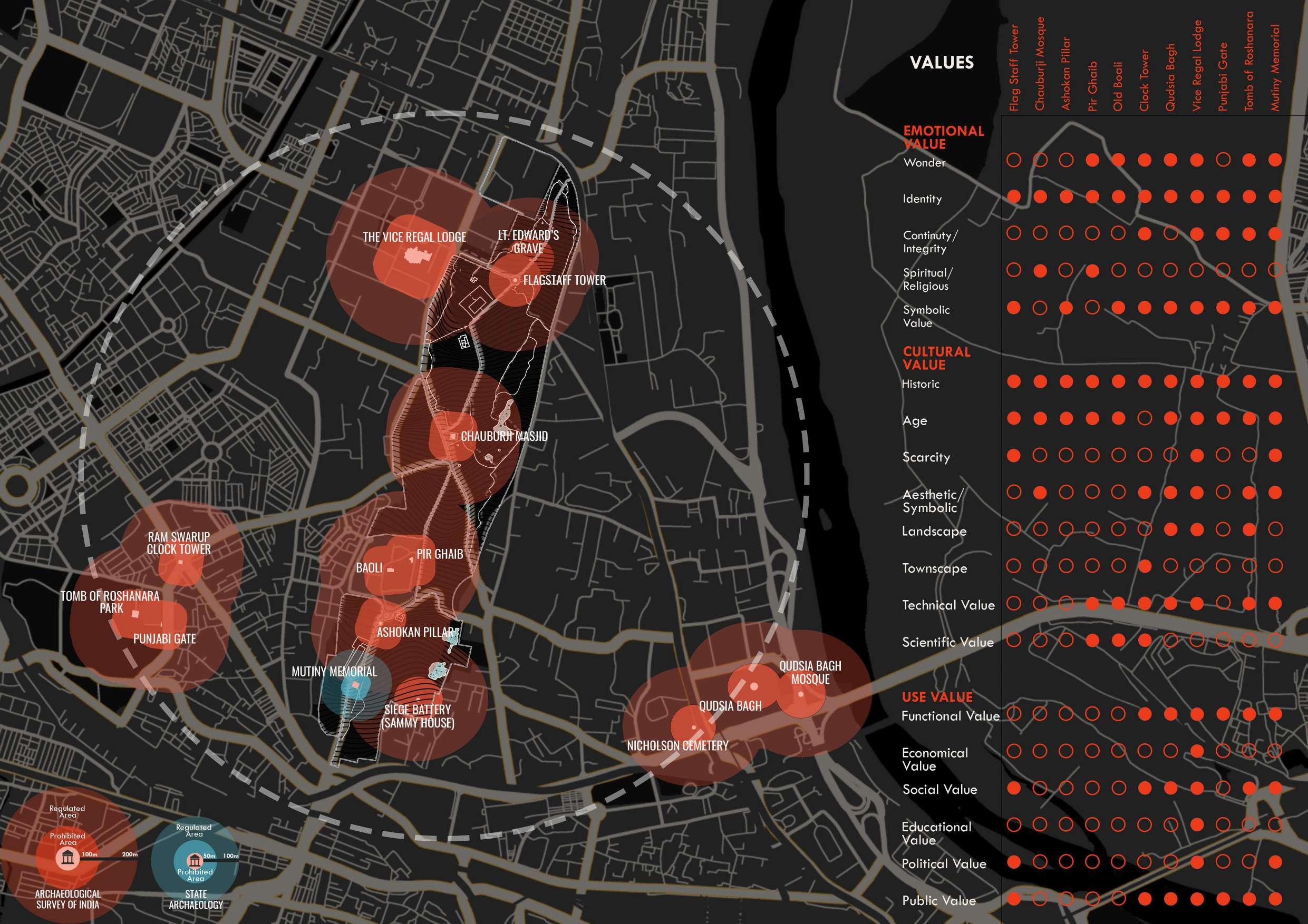
Ashoka pillar was shifted from Meerut by Feroz Shah Tughlaq and was placed at his hunting place. It is a monoithic pillar.

Pir Ghaib, the 14th century monument and the stepwell next to it built by Sultan Firuz Shah Tughla, found use as a hunting lodge and also as an astronomical observatory.
Flagstaff Tower built by the British Indian Army, the building was part of the British cantonment and was used as a signal tower. It is a one-room, castellated tower.
The Chauburja Mosque, fourdomed corner turrets was built during Firoz Shah Tughlaq’s reign as a mausoleum.

The Delhi Ridge was notified as ‘Reserve Forest’ under Indian Forest Act,1927.
The Mutiny Memorial was built in 1863 in the memory of the officers and soldiers of the Delhi Field Force who were killed in 1857.
Provisions of the MPD 2021 makes it mandatory that the Ridge is to be kept free from encroachers and its pristine glory must be maintained.
Under MPD 2001, the morphological Ridge area was notified as forest and the area was included in the ‘Regional Park’.
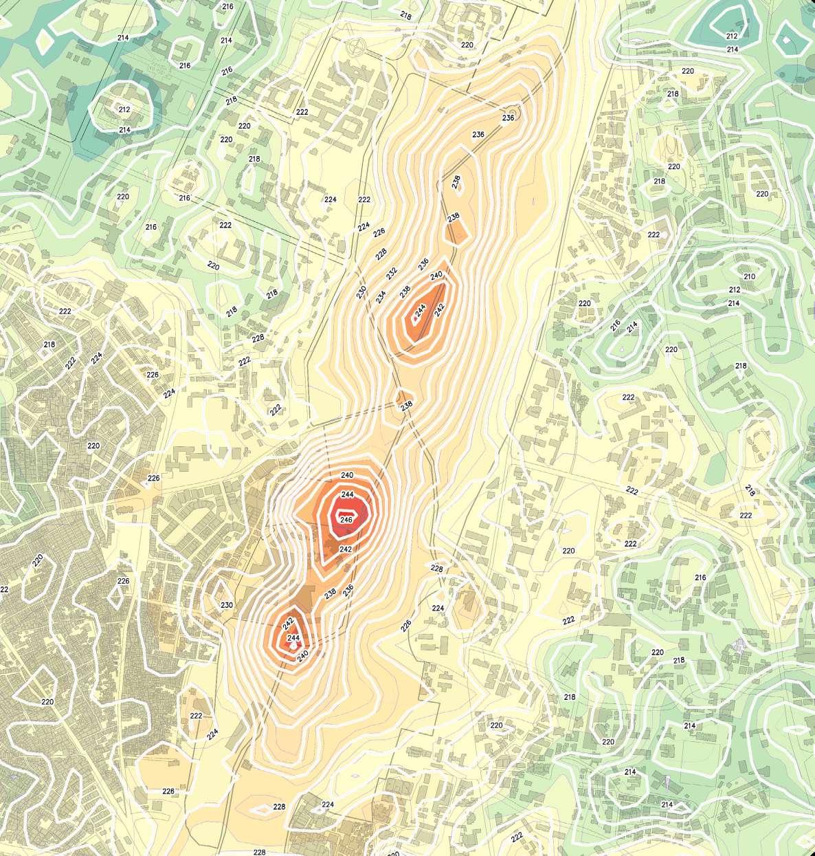


The drainage levels of the ridge are marked in gradients depicting the flow of water from the highest to the lowest level. The dotted lines with arrow depicts potential path for water to flow. The ridge consists of water bodies like the Khooni Jheel and the Sarpakaar Jheel. The Khooni Jheel is an annual waterbody and the Sarpakaar Jheel is a seasonal water body.


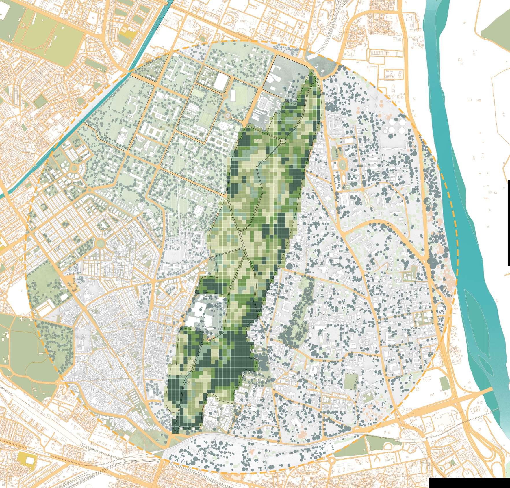
The vegetation density map shows that the denser vegetation is along the edge of the ridge, especially on the Civil Lines side. But, towards the center of the ridge, the vegetation is observed to become sparser.


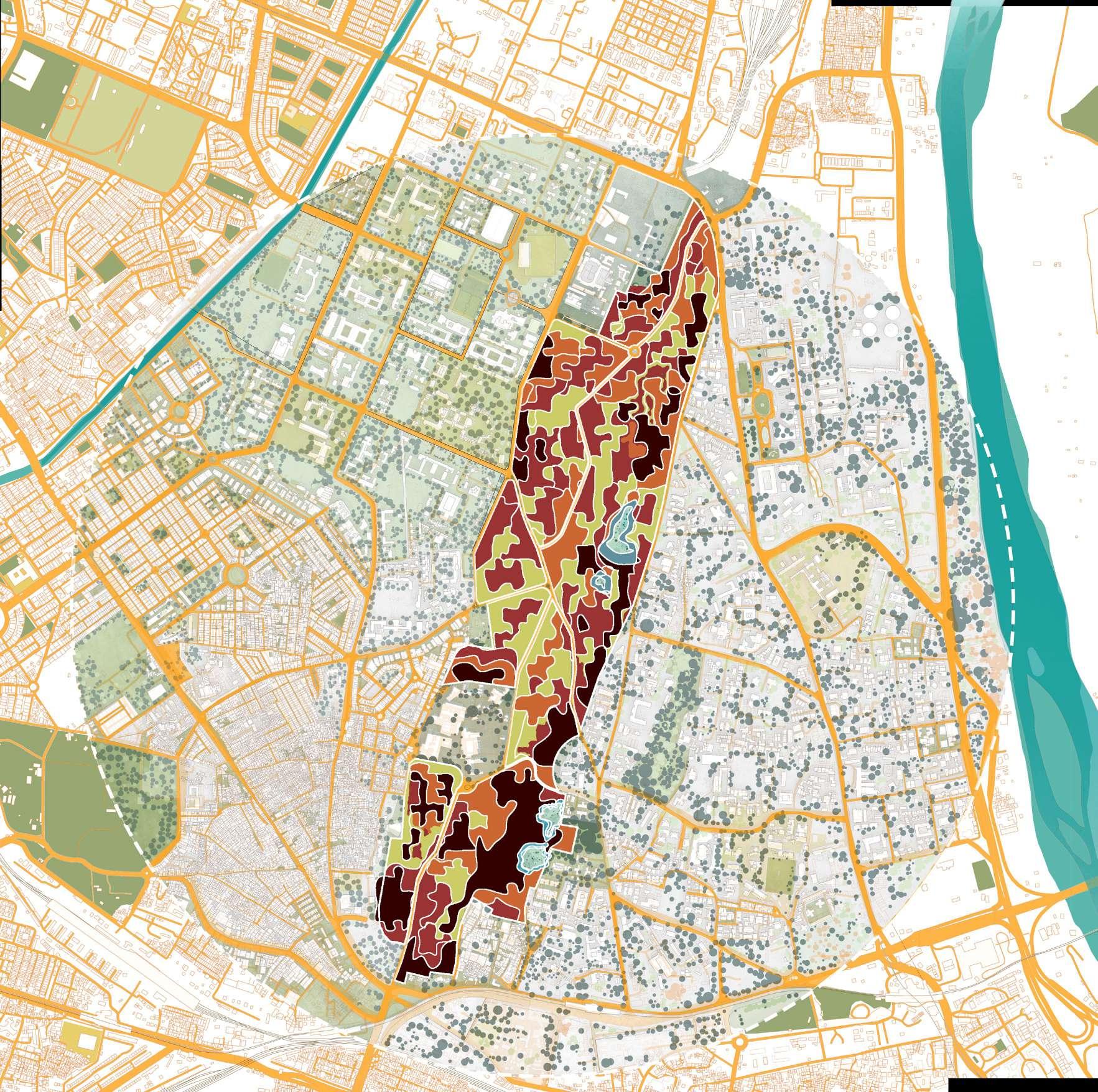
The map shows five zones, very dark tone good for birds and mammals, Orange tone fair for all birds, Red poor area for birds, Yellow area affected by noise pollution. Blue area pond or depressions with water which has potential for aquatic life.


 Reconstructed from vegetation density pollution map and land use.
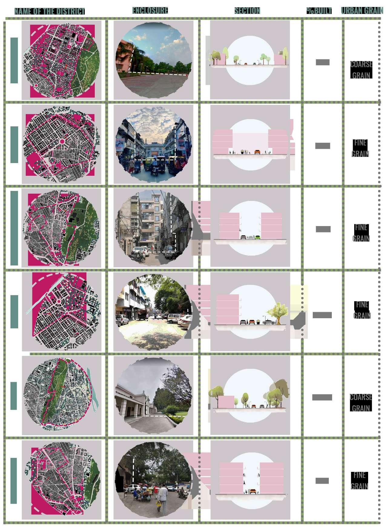
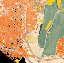
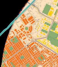
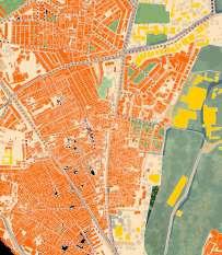
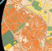
Most of Kamla Nagar has fine urban grain. The built spaces are continuous and dispersed in an irregular pattern, while the other half is well planned and regular.
Coarse grain in the Delhi University region is well planned with lots of open spaces.
Fine and dense grain in Kalyan Vihar and GTB Nagar, with well-organized housing and a good mix of open spaces.
Fine grain is observed in Kabir Basti, Mulka Ganj, and Old Sabzi Mandi are densely populated areas with few open spaces.


Timarpur has a good mix of open and built spaces.
The built up area constitutes 24.68% of the context area and 75.32% remains the open area. The area around the ridge has developed along with due course of time, redevelopment and building of roads has invariably altered the urban fabric of this place. The pattern of streets and paths has evolved over a very long period of time.

The land use depicted in the Delhi University area is the same as marked in the MPD. The area is divided into sections for educational and other public purposes, with open spaces in between.
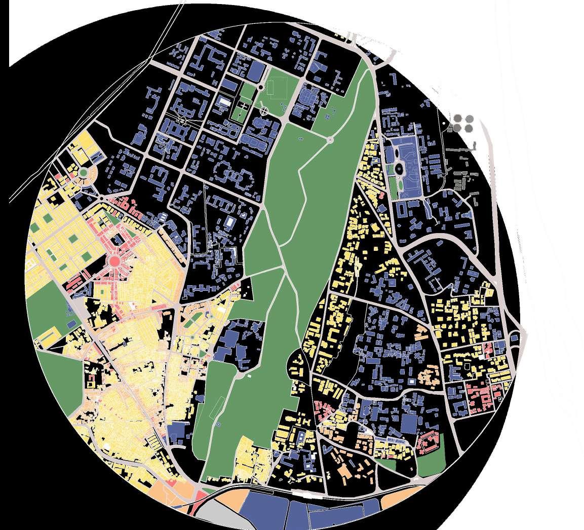

According to MPD, the Kamla Nagar colony is half residential and half transportation, though on-site, it is largely residential and partly commercial.


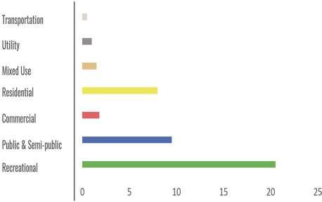


The Vidhan Sabha region is designated as a residential zone in MPD, but it houses key government offices, healthcare and educational facilities, making it a Public & Semi-Public zone as well as partially a residential zone.
The on-site land use in Civil Lines is similar to what is proposed in the MPD. The land here is zoned for residential, public, and mixed use.
According to what is intended in the MPD and what is actually in the region surrounding Kamla Nehru Ridge, it is obvious that the surrounding area lacks sufficient open spaces, making this ridge an efficient space for the people living nearby.
The mapping shows the elements of recreation present in the context of the ridge.
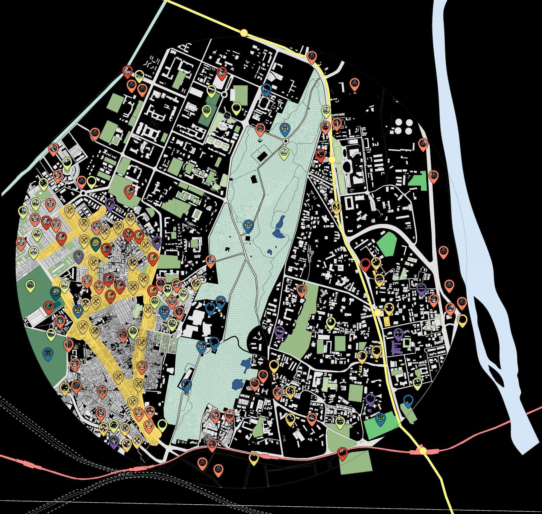
Food and beverages & Retail - Spaces which have a wide variety of food products and shops.


Religious - Spaces which require act of devotion, activities which are related to a person’s spirituality and mental peace. Health / sports – spaces which provide both physical and mental relaxation and peace.

Ceremonial spaces & Public Spaces - Spaces which are used to host parties or performances, huge public gatherings, they can be both open and built.
Amusement & entertainment- spaces which people visit in order to experience excitement, enjoyment, pleasure, amusement, humour, etc.
Interpretation & Tourism - Spaces which provide some sort of learning.
Hospitality Spaces which provide with an experience of relaxation and comfort by pampering the guest in all ways possible.
The mapping shows the elements of recreation present in the context of the ridge. Kamla Nagar has the most recreational spaces, which could be used for ancillary services. Kamla Nagar, Punjabi Basti also act as potential users of the ridge.
Civil lines has the least amount of recreational spaces hence they rely on the ridge as well the old Kamla Nagar market.

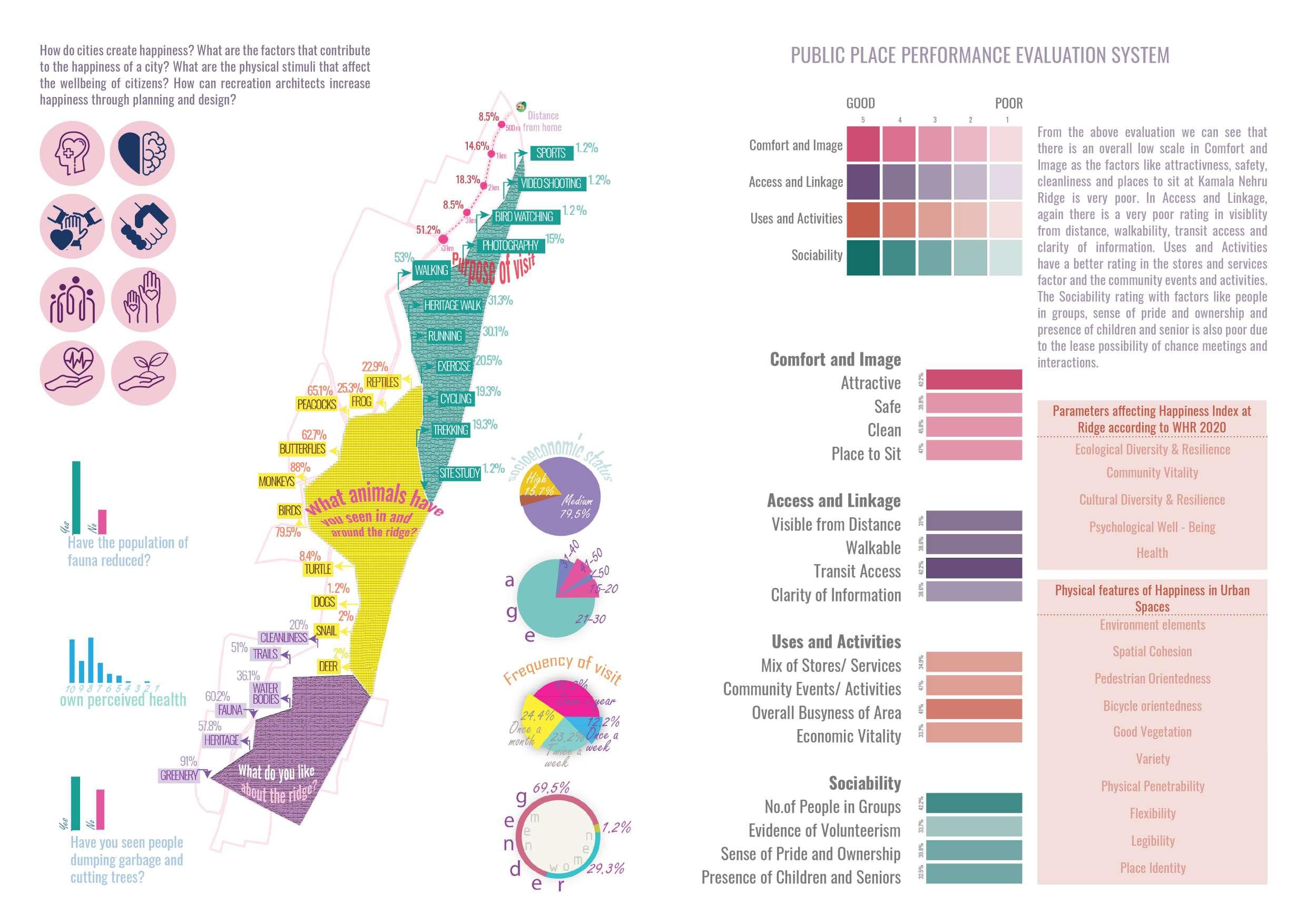
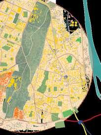

Government organizations are experimenting with new policies and ideas to promote recreational activities and protect existing open spaces. Even with such attempts being followed, loss of open areas to encroachment reflects a need for planned initiatives with periodic monitoring. With increasing urbanization, the requirement of open spaces for recreational activities increases. However, the minimum standard of open area required per person have been decreased tremendously over the three master plans been decreased tremendously over the three master plans per person have been decreased tremendously over the three master plans Better planning of open spaces is required for equitable distribution of recreational spaces within residents of all zones. Gap between planning and implementation needs to be analysed at policy level. Well-designed streets that promote walkability and easily available resources at walkable distances act as a city to form the ground for recreation itself.
sports, yoga, meditation, walking, birthday celebrations
walking, sitting, playing
Is planned according to a grid iron pattern with larger grains. district mainly consists of privately owned play grounds. Planned according to the number of residences while the old area is congested but is lively, hangout spot for students.


walking, sitting, playing, talking
Unplanned urbanisation that is congested without enough urban green spaces for recreational activities.
cycling, walking
Is a part of the Malika Ganj. This district lies closest to the morthern ridge but it doesn’t have individual lawns or parks along the residences.
walking, sitting, playing, jogging -
football, cricket, walking, sitting, playing, jogging
Radial grid pattern such that each residence has an open green space within 200 m radius. Accessible through road from both sides. T raditional area of old Delhi,marked as a special redevelopment area in MPD 2021.Informally with small grains. no green spaces in this area. Informally planned large residential plots having lawns. medium residential density. The open spaces in this area consists of playgrounds - football, cricket and basketball grounds.

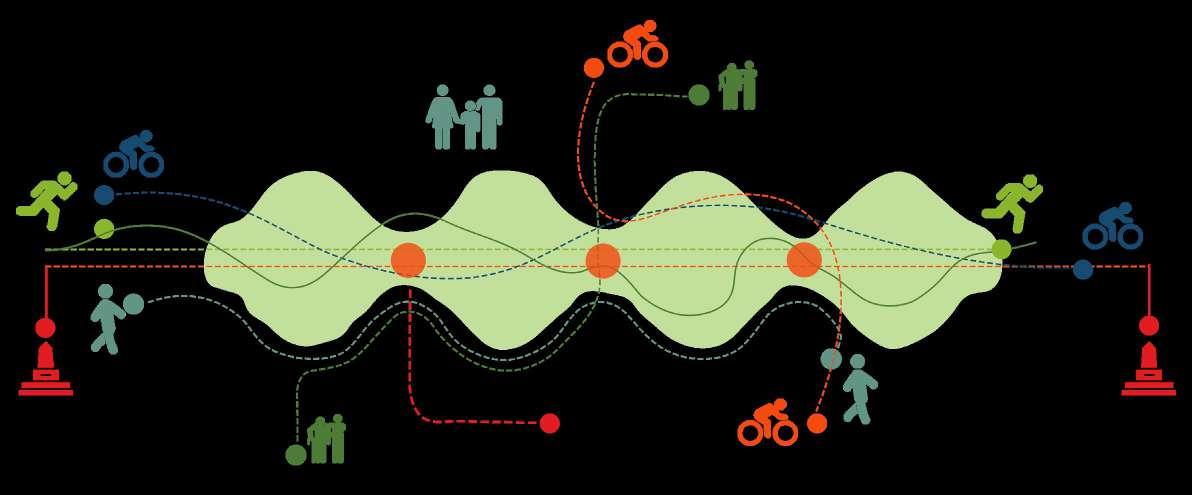
The first map shows the path taken by cyclist, followed by a map showing path taken for running and walking by the visitors.The third map shows the intensity of visitors with respect to different areas of ridge, where we can clearly tell most of the visitors were around the monuments and khooni jheel.
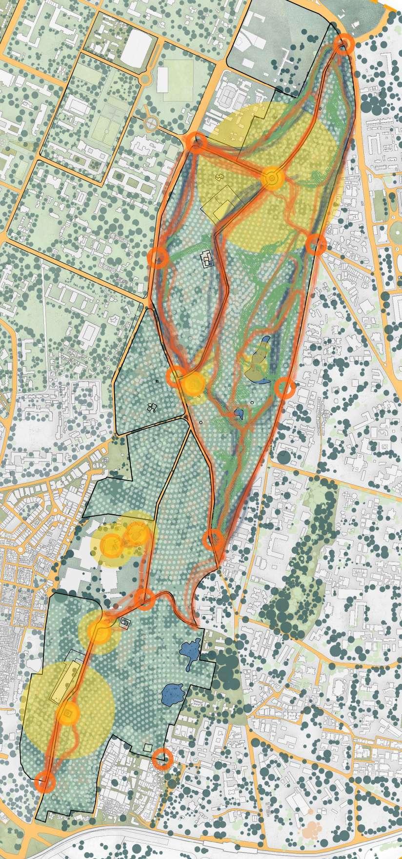

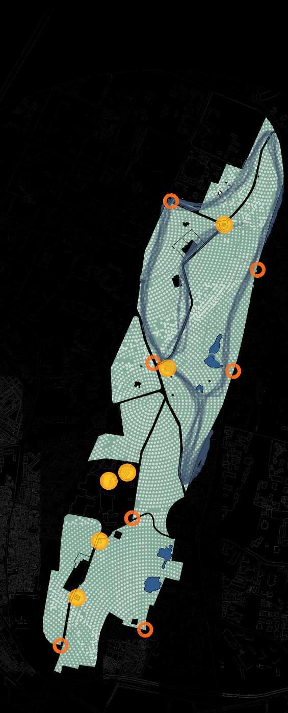
All three mappings were combined and placed on the base map to formulate a reltionship betwwen our mappings and the surrounding context. From this we found out that the gate near the delhi university campus is most used and residents of civil lines use this park inthe morning and evening for walking nd other physical activities

Vishwavidyalaya


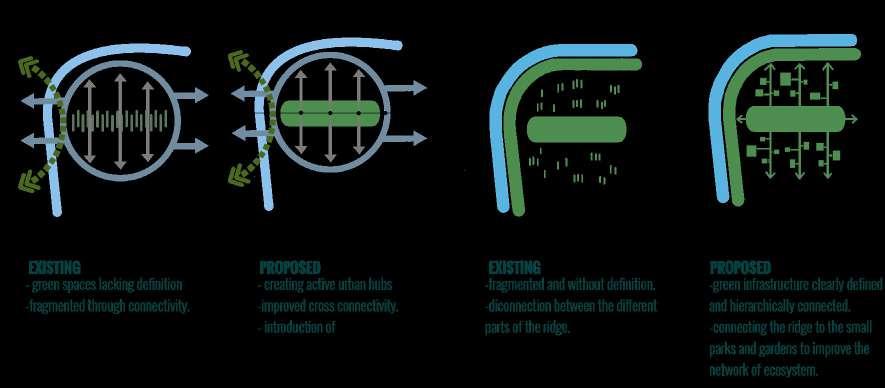
1. Establish a wider ecological corridor along the ridge and strengthening the role of ridge as a lifestyle precinct.
2. Investigate the opportunities to underground the existing High Tension Power lines along/ away the ridge to improve amenities and increase areas for open spaces.
3. Provide safe and pleasant pedestrian and cycling connections between the metro stations and ridge.
4. Rethink Kamla Nehru Ridge as a Natural Heritage, enhancing visual and physical access to and from the neighboring areas.
5. Use the existing heritage layer in and around the ridge to provide heritage walks and circuits.
6. Providing high quality recreational opportunities in and along the ridge and promote more people to acknowledge the existence of the ridge.
7. Identifying the green spaces around the ridge and analyze the quality and quantity of the green spaces.
8. Analyze areas which lack green spaces and have high density such as Kamla nagar, old sabji Mandi, etc. and establish a connection between such areas and the ridge.
9. Education programs and excursion for neighboring schools and colleges.(kids should be sensitized toward the importance of ridge in order to bring up a generation which understands its necessity and the need to be preserved)
10. Introduce ridge as subject to study for various Delhi University programs, the studies will help educate people about the importance of ridge and further sensitize towards it.
11. A number of hospitals surrounding the ridge can use it for better mental and physical health of the patients. (Like healing gardens, there are a number of flora present on the ridge which have healing and medicinal properties).
12. The nearby recreational areas such as Kamla Nagar market can act as potential footfall carrier for the ridge.
Kamla Nehru Ridge
Delhi University Roop Nagar
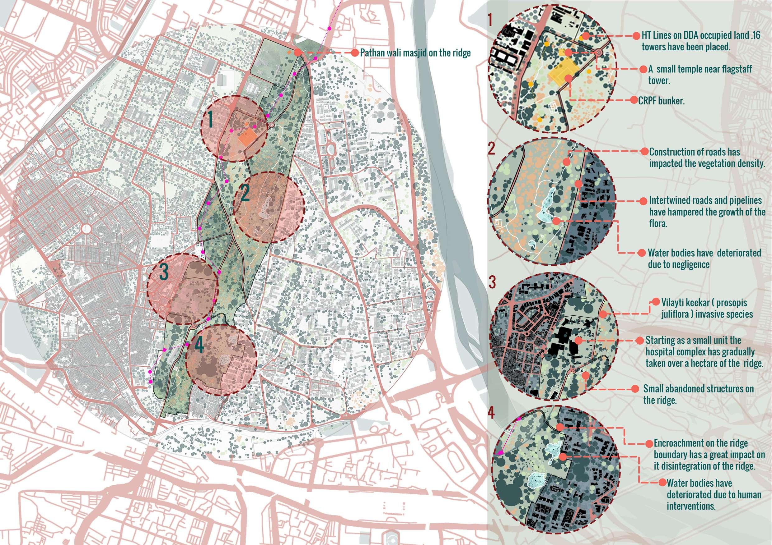
1. The existing historic layer in the ridge is protected by ASI and State Archeology, according to their guidelines the monument has a 100m protected area and 200m reserved area. No construction can be done in the protected area and for the reserved area, permissions are required from the competent authority Until the construction is done for the public benefit. Therefore reducing the options for the development of the ridge.
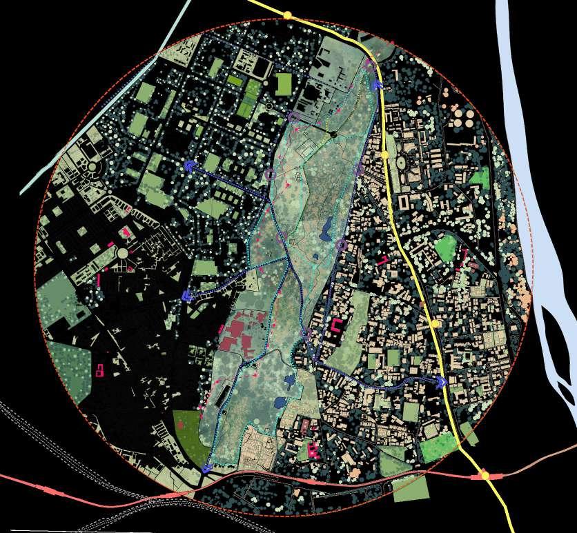
2. The existing roads dividing the ridge into parts are one of the major causes of degradation, pollution, and noise stress affecting the flora and fauna.
3. A visual dominance of power poles and overhead power lines in the ridge impacts the landscape precluding tree planting.
4. Pipelines passing through the ridge.
5. Nearby people feed the monkeys which causes menace of the monkeys which further destroys the native tree plantings.
Roshnara
Bagh
6. Lack of pedestrian-friendly and cycle tracks connecting different parts of the ridge.
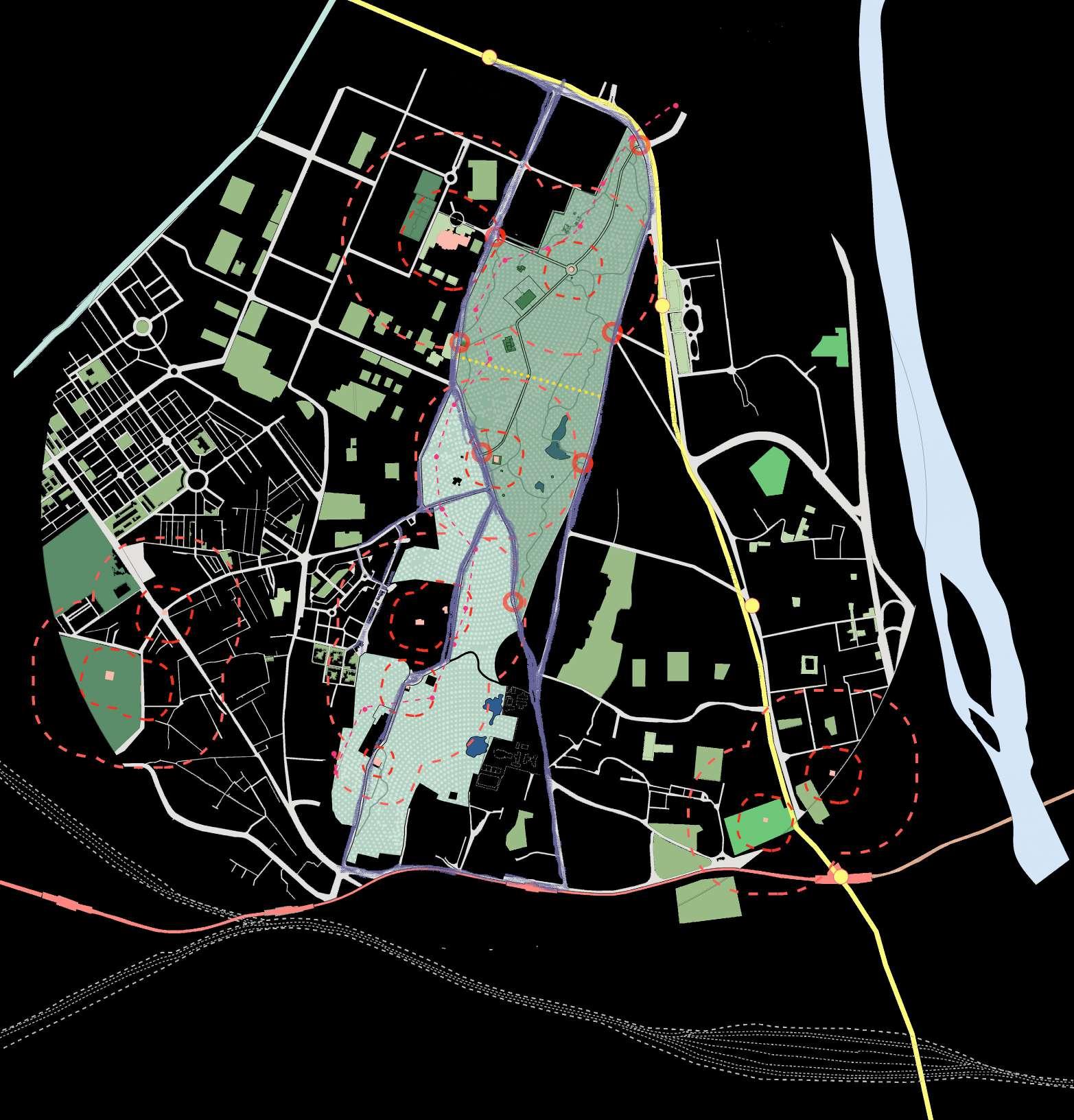
Civil Lines
7. The site is sub-divided among various agencies (DDA, Delhi Forest Department, North Delhi Municipal Corporation) that would raise an issue while proposing any changes to the site. Causing unequal development of ridge areas.
lower part of the ridge
upper part of the ridge
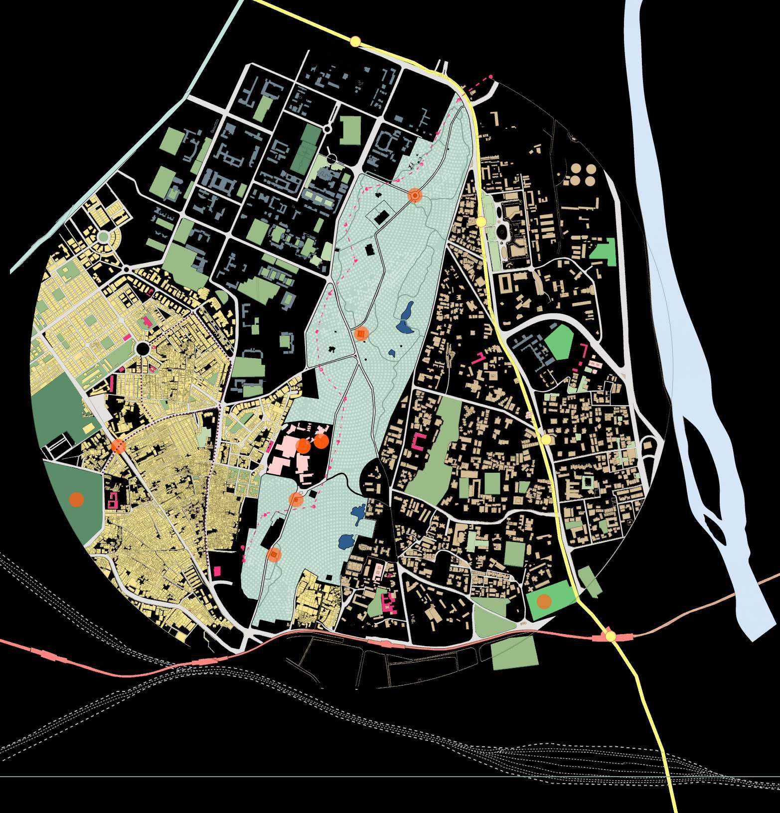
Gates
Old Sabji Mandi Legends
Roads through the ridge
Tis Hazari
Yellow Line- Metro
Red Line- Metro
High Tension Wires
Pipes Lines
Heritage sites
Road Network


Kashmere Gate
8. Gates are not strategically planned, need to be relocated according to public transport systems.
9. The dominance of the Kikar tree hampers the growth of other trees on the ridge.


The local history and recent development on site have left multiple issues such as fragmented parcels, construction waste, and disturbed ecosystem. In addition, Delhi experiences severe urban heat island effects, as well as environmental challenges brought about by rapid industrialization and urbanization. To alleviate these stresses, the project objectives are:
1) CONSTRUCT a green urban ventilation corridor that establishes connectivity between the city’s various ecological zones.
2) REHABILITATE this site’s ecosystems for native plants and animals.
3) ESTABLISH a lively and contemporary green space that satisfies the needs of the city and its residents.
4) CREATE a space that promotes environmental ideals and acts as a base for future research and design of ecological corridors and urban ventilation spaces.
•Urban flooding
•Solid waste pollution
•Landuse change
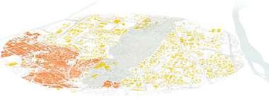
•Polluted water bodies.
BENEFITING SOCIO-SPATIAL STRUCTURE


•Weak accessibility to the ridge
•Lack of urban revitalisation
•Elimination of small scale urban greenery

•Lack of facilities
•Lack of recreational spaces.
•Naturilised lake and streamflows
•Replantation on barren land
•Thriving wetlands
•Zero eutrophication
•Varied productive landscape


•Inclusive green/open spaces
•Development of social facilities
•Reuse of vacancy
•Guided urban development
Replenishment of water table - Urban Forests are excellent at enabling water to penetrate the earth and replenish the water table.
Zero Eutrophication - Rejuvenating existing water bodies and avoiding future degradation, limiting the impact, and restoring aquatic life.
Diverse Greenery - Including native trees, species that are already adapted to the environment which don’t need any extra water or nutrients.
Varied productive Landscape - Diversified use of land, preventing soil erosion and over exploition.
Prevention from degradation - Restoration of the ridge from current degradation, proposals to prevent it further through design and policies.
Educational Space- The Park will serve an important role in educating the citizens, especially children on the signifcance of the Aravalis its fl ora, fauna, ecological restoration and water conservation.
City Forest- Conserving ecosystems which inherited from wilderness leftovers, with amenities like public bathrooms, paved paths, clear borders,park like features.
Sustainable Forest- Increasing afforestation, diversifying existing forest, planting native trees.
Inclusive built environment- Community oriented urban design including diverse social needs, social cohesion.
Improve accessibility- Indicated areas in terms of connectivity and access to services, minimalizing environmental impact.
Creating a Balance- Balancing impact of build environment through regeneration of natural environments.
Native trees are planted around the ridge in barren patches.
Ecological seams.
The boundary walls are demarcated and redesigned to improve sightlines.
Edge condition treatment.
Vehicular movement pattern around the ridge .
NO INDUSTRIAL ZONE
Vehicular movement.
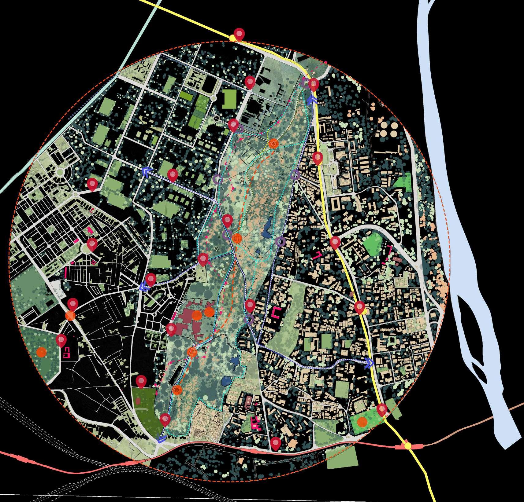
PBS circuit is developed to improve accessibilty to the site. PBS stops are at a distance of 1 km.
Heritage monuments.
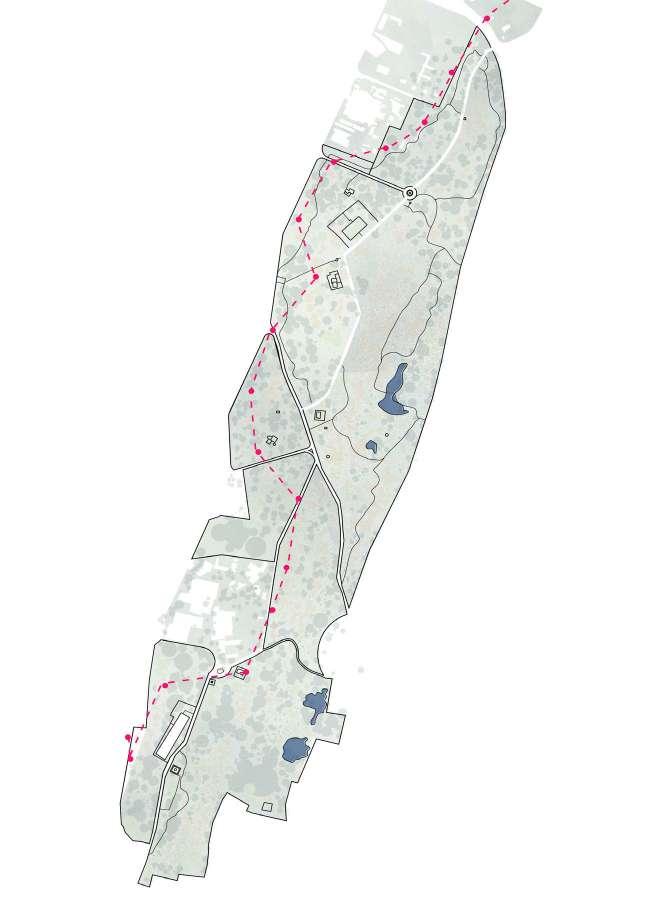
Heritage walk route starting at the interpretation center covering all the heritage buildings in between.
PBS circuit.
Heritage stops.
Heritage walk.
A radius of 1.5km is marked as no industrial zone.

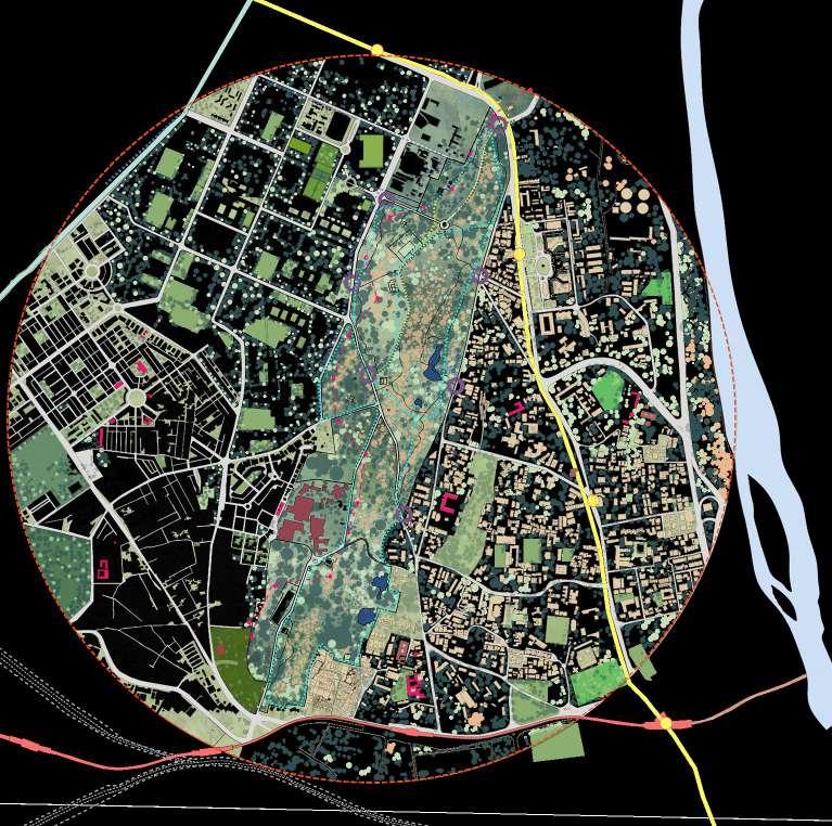


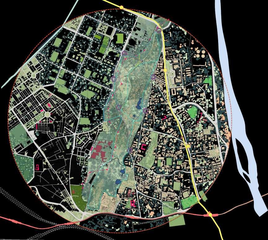

PBS Stops. No industrial zone.
PBS system is introduced to connect the ridge with the rest of the site.
• A conservation action plan should be prepared for both the natural and cultural heritage.
• The green spaces present around the ridge connected to the ridge to create and ecological seam.
• Vehicular movement is restricted to the roads on the periphery of the ridge.

• PBS system is introduced to connect the ridge with the rest of the site.
Heritage circuits are created to increase the heritage value of the site.
No industrial zone
• Heritage circuits are created to increase the heritage value of the site.
• Heritage walk created to raise awareness about the rich heritage present in the context of the ridge.
vehicular movement is restricted to the roads on the periphery of the ridge.
A conservation action plan should be prepared for both the natural and cultural heritage.
• Civil lines is marked as the character district of the zone, preservation of the site is needed due to the presence of multiple architectural characters.
• Parking area proposed in Kamla Nagar to allow people with private vehicles acess to the ridge.
Heritage circuits. Heritage stops.
No industrial zone.
PBS circuit.
Heritage walk created to raise awareness about the rich heritage present in the context of the ridge.
The green spaces present around the ridge connected to the ridge to create and ecological seam.
Edge condition treatment. Vehicular movement. Heritage monuments. PBS Stops.
Heritage walk. Ecological seams.
Central spine- developed with all the heritage and ctive passive recreational activities.
Healing garden - curating healing gardens for the hospitals.
Reserved forest- some parts of the ridge are marked as reserved forest, to keep intact the ecology of ridge. Creating water fronts- the existing lakes are rejuvinated to create a public zone.
LEGEND NURSERY
ENTRY
DRINKING WA TER
WASHROOM

INTERPRETATION CEN TRE PARKING

Flexible recreation spacediverse temporal acitivities are promoted.
PBS/ CYCLING STANDS
FOOD KIOSK

ACTIVE RECREATION SPOTS
PASSIVE RECREATION SPOTS

Improved cycling tracks- the movement pattern is made articulate.
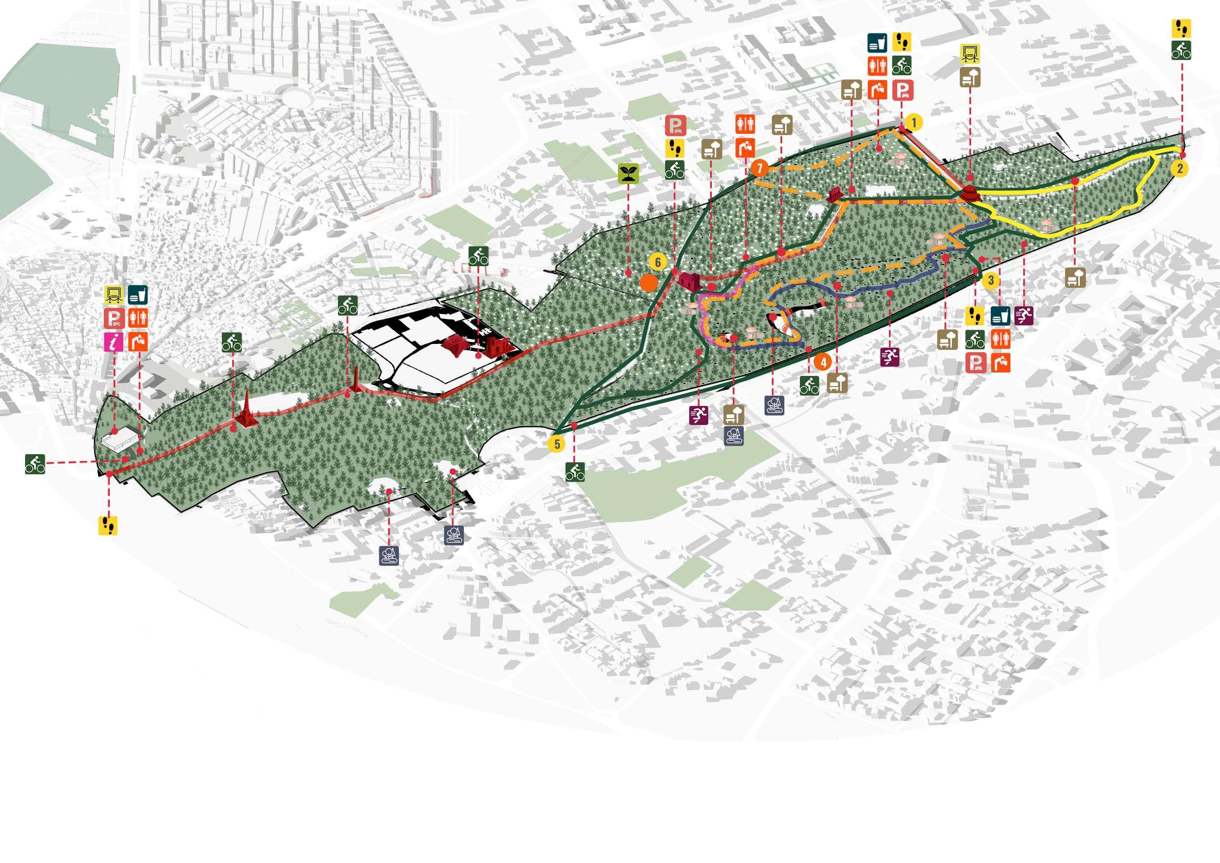
Heritage walk- the walk is designed by connecting all the heritage monuments present on the site
WATER EDGES
EXHIBITION SPACE/ DISPLAY/GALLERY
GOLDEN TRAIL (Amaltas)
EDUCATIONAL TRAIL
PINK TRAIL(Bougainvillea)
Defined trails- the natural trails are made unique by planting different trees along them, to create experiential design.
Conserved existing lakes- existing lakes has been retained and conserved to make it a part of the public recreational spaces.
HERITAGE WALK
BIRD TRAIL
WALKING/ CYCLING TRACK
GATES TO BE RETAINED
GATES TO BE CLOSED
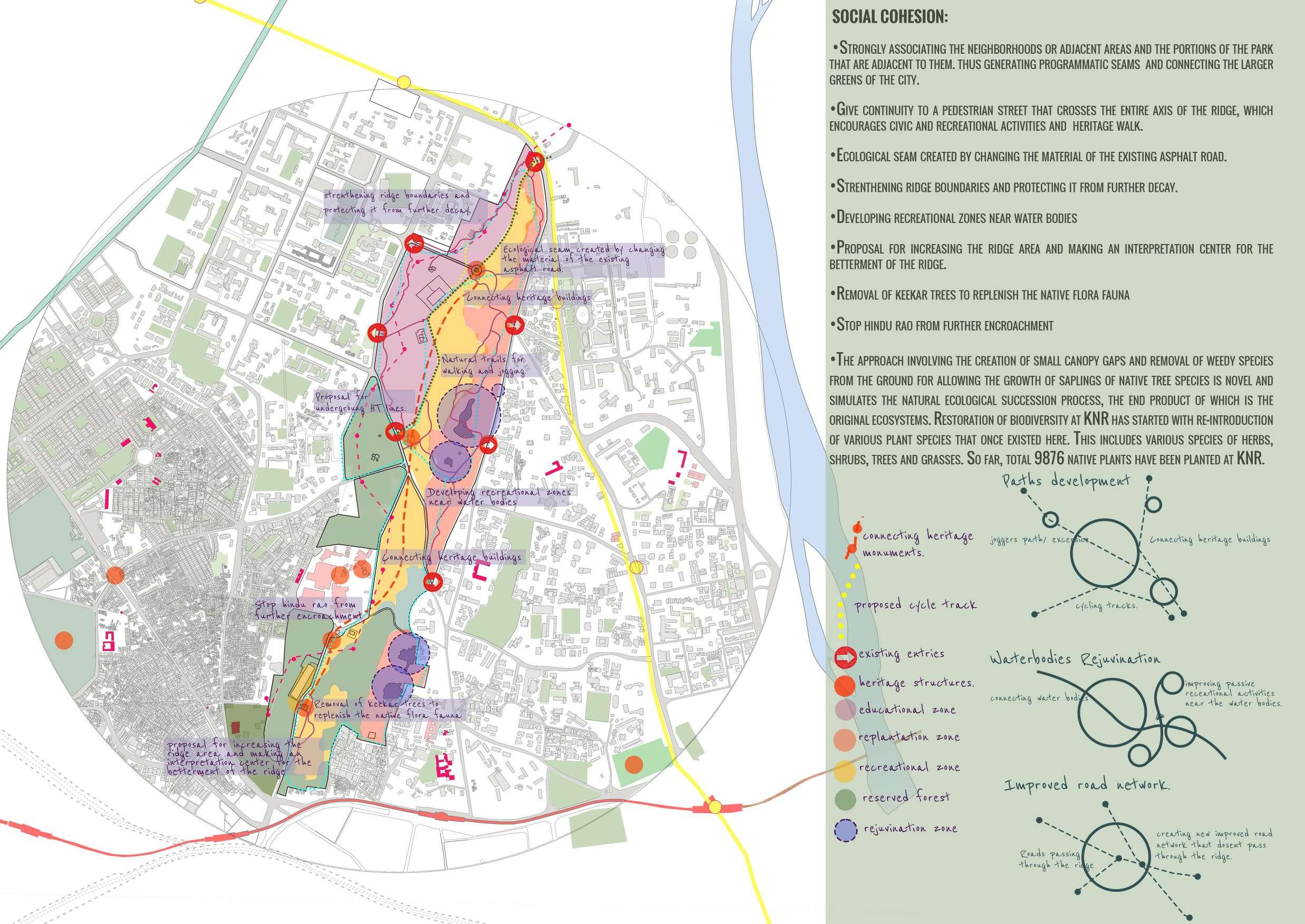
A central spine with high intensity of recreational and ecological zones is created. The spine consists of the heritage walk starting from the south of the ridge covering first the mutiny memorial and ending at the flag staff tower. Both active and passive recreational activities are planned to intermingle and create a sociable public space. The recreational activities minimally interfere with the ecology of the ridge.
Existing water bodies are replenished and an improved man-water interaction is promoted. The plan propose a concept of urban forest Park to conserve and manage the ridge by creating a quality public space and a balanced ecosystem for all its stakeholders.
The details of various parts of the sites are developed using the above policies and stratergies. Interpretation centre is developed to create awareness and for the protection of the ridge. Exisiting trails are developed upon by proposing multiple unique recreational activities to improve on the socio cultural aspect of the ridge. Ecological character zones are created by removal of invasive species and replantation of native trees to form a well balanced ecosystem.
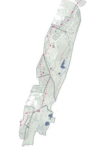
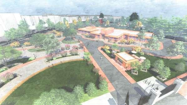

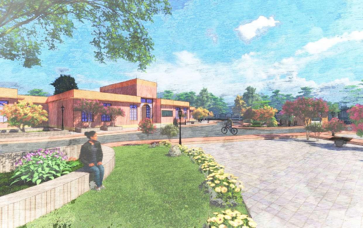


Paved pathways guided by natural




PROPOSED SITE SECTIONS

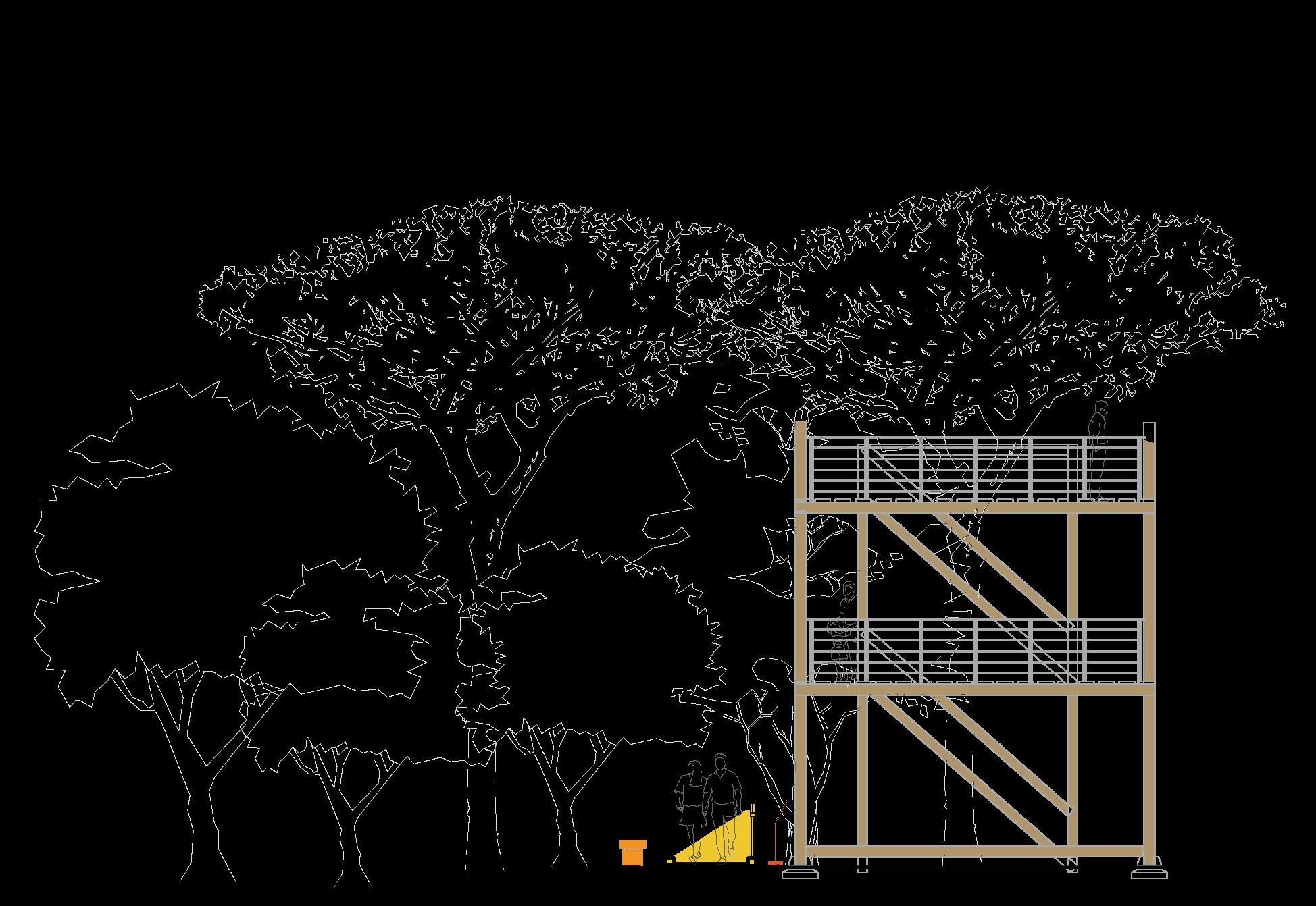
The proposed site sections are along the central axis with the maximum number of activities and character zones marked. The trails are divided into var ious types based on the trees, active and passive recreational activities. The existing terrain is retained and the keekar trees are removed and native trees are replanted. ancillary activites are also planned along the central spine.


NURSERY
CYCLING TRACKS
FOOD KIOSK
ACTIVE RECREATION SPOTS


PASSIVE RECREATION SPOTS


EDUCATIONAL TRAIL
PINK TRAIL(Bougainvillea)
BIRD TRAIL
WALKING/ CYCLING TRACK


GATES TO BE RETAINED
GATES TO BE CLOSED
ENTRY
DRINKING WA TER
WASHROOM


INTERPRETATION CEN TRE
PARKING


0 100 200 400 0 100 200 400
A’


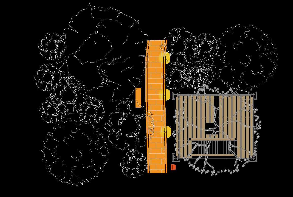
THE TRELLIS AROUND THE FLAG STAFF TOWER PROVIDES A WELL SHADED AREA WHICH CAN BE USED FOR EXHIBITIONS SUNDAY MARKET, LIGHT AND SOUND SHOWS CREATING WELL INTEGRATED SOCIAL SPACE.


Biodiversity profile
87 native plant species, 64 bird species, 7 species of mammals, 3 species of amphibians and 31 species of butterflies have been recorded. The Ridge is highly weathered resulting in undulating topography with many high and low points. Consequently, the Ridge has flat hill tops, shallow valleys and gentle slopes. The Ridge is fragmented due to City Roads that traverses through the Ridge in criss cross manner and infested by a Mexican weed- Prosopis juliflora, commonly known as Kabuli Kikar or Vilayati Kikar, which was introduced by British Colonial Government for greening the Ridge. Within 150 years of introduction on the Ridge it has eliminated many native plant and animal species. The major objective is to bring back the pristine native forest communities of Aravalli Hill Ranges that once thrived in the Ridge. Canopy Opening method and cut rootstock method have been used for the management of Prosopis juliflora. To allow the saplings planted to grow, small canopy gaps have been created by pruning dead branchlets of the invasive alien Prosopis juliflora, which as per International Conventions, and recommendations of FAO, has to be eradicated. Lantana, another noxious alien species, which is being eradicated from protected areas, has been removed to create space on the ground. With opening of the canopy, native plants get abundant sunlight for their growth and survival and slowly they out-compete the Prosopis juliflora.

Through our indepth analysis consisting of the ecological layers , recreational suitability and the morphological layers along with surveys, we have been able to come up with certain interventations and policies. We formulated policies of the Ridge Management Committee for the smooth functioning and specific management of the ridges in Delhi. We also constitued polices focusing on the Northern ridge and proposed interventions which we thought were necessary through the overlapping and analysis of variours layers of mapping. These policies and interventions also go hand- in-hand with the MPD 2021 &2041.
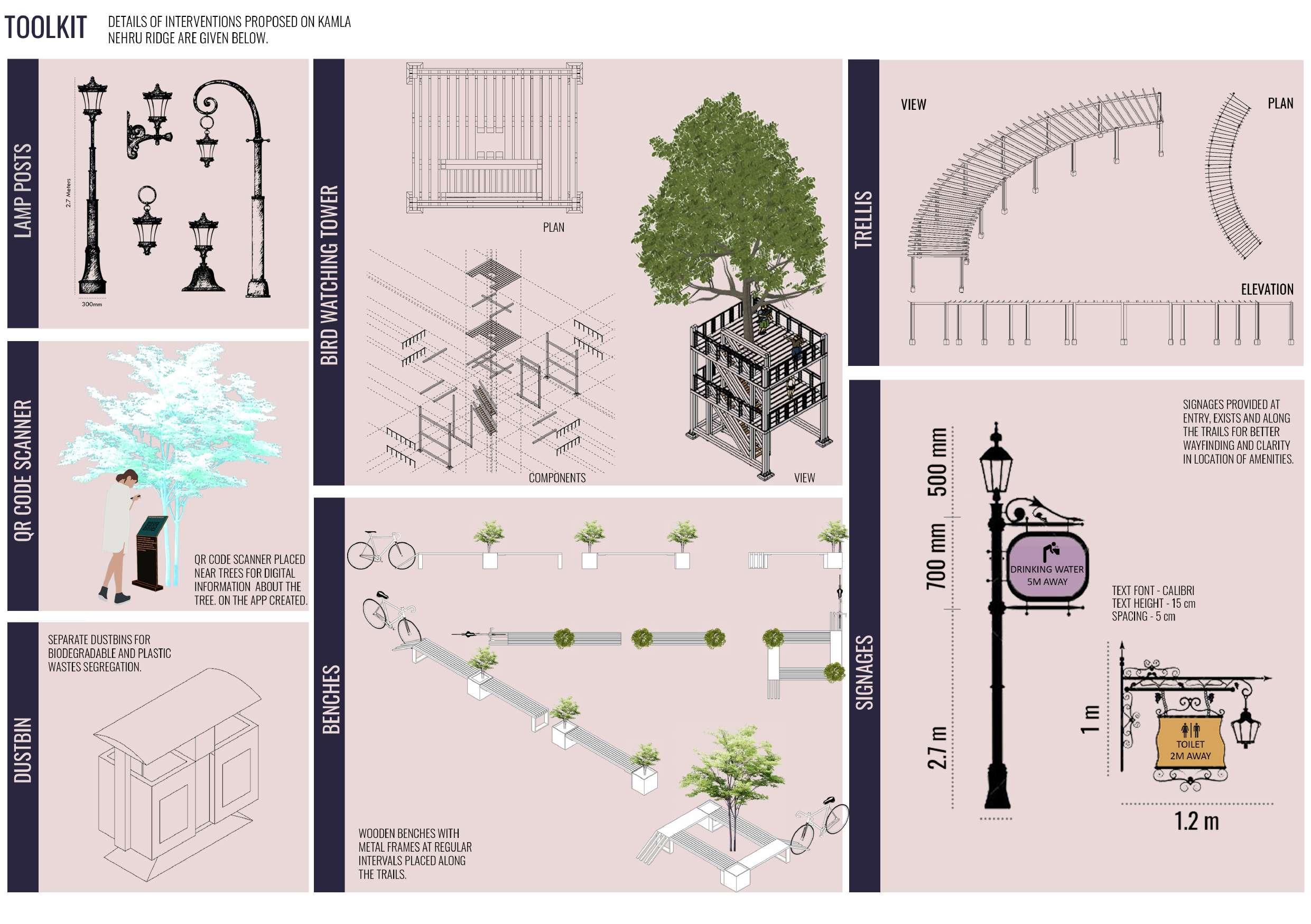
Brief of some of the intervention proposed are given belowassisted living small community large community
Kamla Nehru Ridge being a part of the Aravalli ranges plays an important role in the ecosystem of Delhi. Due to urbanisation and other factors discussed there is a constant threat of degradation to the ridge. In our project we have tried to propose interventions to maintain the ecological balance and also use the ridge as a prominent recreational space for the residents living around the ridge, thus improving cultural diversity and resilience, community vitality, health, physcological well-being, ecological diversity and resilience therefore the happiness index of the area.
The local history and recent development on site have left multiple issues such as fragmented parcels, construction waste, and disturbed ecosystem. In addition, Delhi experiences severe urban heat island effects, as well as environmental challenges brought about by rapid industrialization and urbanization. To alleviate these stresses, the project has achieved-
1) CONSTRUCT a green urban ventilation corridor that establishes connectivity between the city’s various ecological zones.
2) REHABILITATE the site’s ecosystems for native plants and animals.
3) ESTABLISH a lively and contemporary green space that satisfies the needs of the city and its residents.
4) CREATE a space that promotes environmental ideals and acts as a base for future research and design of ecological corridors and urban ventilation spaces.
• A conservation action plan should be prepared for both the natural and cultural heritage.

• The green spaces present around the ridge connected to the ridge to create and ecological seam.
• Vehicular movement is restricted to the roads on the periphery of the ridge.
• PBS system is introduced to connect the ridge with the rest of the site.
• Heritage circuits are created to increase the heritage value of the site.
• Heritage walk created to raise awareness about the rich heritage present in the context of the ridge.
• Civil lines is marked as the character district of the zone, preservation of the site is needed due to the presence of multiple architectural characters.
• Parking area proposed in Kamla Nagar to allow people with private vehicles acess to the ridge.
