Guidance for Application GUIDANCE IN APPLYING THE PROJECTIONS
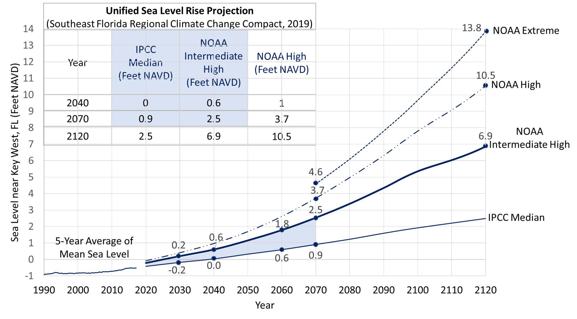
Audiences The Unified Sea Level Rise Projection for Southeast Florida is intended to be used for planning purposes by a variety of audiences and disciplines when considering sea level rise in reference to both short- and long-term planning horizons as well as infrastructure siting and design in the Southeast Florida area. Potential audiences for the projections include, but are not limited to, elected officials, urban planners, architects, engineers, developers, resource managers, and public works professionals. One of the key values of the projection is the ability to associate specific sea level rise scenarios with timelines. When used in conjunction with vulnerability assessments, these projections inform the user of the potential magnitude and extent of sea level rise impact at a general timeframe in the future. The blue shaded portion of the projection provides a likely range for sea level rise values at specific planning horizons. Providing a range instead of a single value may present a challenge to users such as engineers who are looking to provide a design with precise specifications. Public works professionals and urban planners need to work with the engineers and with policymakers to apply the projection to each project based on the nature, value, interconnectedness, and life cycle of the infrastructure proposed. Finally, elected officials should use the projections to inform decision-making regarding adaptation policies, budget impacts associated with design features that address future sea level rise, capital improvement projects associated with drainage and shoreline protection, and land use decisions.
Applying Projection Curves to Infrastructure Siting And Design When determining how to apply the projection curves, the user needs to consider the nature, value, interconnectedness, and lifespan of the existing or proposed infrastructure. An understanding of the risks that critical infrastructure will be exposed to throughout its life cycle such as sea level rise inundation, storm surge, and nuisance flooding and a plan for adaptation must be established early in the conceptual phase. A determination must be made on whether or not threats can be addressed mid-life cycle via incremental adaptation measures, such as raising the height of a sluice gate on a drainage canal. If incremental adaptation is not possible for the infrastructure proposed and inundation is likely, designing to accommodate the projected sea level rise at conception or selection of an alternate site should be considered. Forward thinking risk management is critical to avoiding loss of service, loss of asset value, and most importantly loss of life or irrecoverable resources. The guidance in the following paragraphs can be considered for selection of curves from the projection for project applications.
Unified Sea Level Rise Projection: 2019 Update
13