
CAROLINA PLANNING JOURNAL VOLUME 47 2022 PLANNING FOR HEALTHY CITIES
CAROLINA PLANNING JOURNAL
Carolina Planning Journal is the annual, student-run journal of the Department of City and Regional Planning at the University of North Carolina at Chapel Hill.
COPYRIGHT AND LICENSE
© Copyright 2022 Carolina Planning Journal
This work is licensed under a Creative Commons Attribution-NonCommercialShareAlike 4.0 International License
EDITOR-IN-CHIEF
W. Pierce Holloway
MANAGING EDITOR
Emma Vinella-Brusher
EDITORIAL STAFF
Rachel Auerbach
PRINTING
A Better Image Durham, North Carolina
ACKNOWLEDGMENTS
Funding for this publication was generously provided by the Nancy Grden Graduate Student Excellence Fund, which supports graduate students working directly with the department’s Carolina Planning Journal, the John A. Parker Endowment Fund, the North Carolina Chapter of the American Planning Association, the Graduate and Professional Student Federation of the University of North Carolina at Chapel Hill, and our subscribers.
Carolina Planning Journal
Department of City and Regional Planning University of North Carolina at Chapel Hill CB #3140, New East Building Chapel Hill, NC 27599-3140 USA
Ruby Brinkerhoff
Lance Gloss
Walker Harrison
Rene Marker-Katz
Cameron McBroom-Fitterer
Amy Patronella
CONTRIBUTORS
Jordan April
James Hamilton
Sarah Kear
Jo Kwon
Sophia Nelson
Isabella Niemeyer
GRAPHIC DESIGNER
Emily Hinkle
COVER PHOTOGRAPHER
Josephine Justin
SPECIAL THANKS
The Carolina Planning Journal would also like to thank the many people who have helped us this year, including Ben Howell and Bonnie Estes from the North Carolina Chapter of the American Planning Association, our faculty advisor Andrew Whittemore, DCRP accountant Kathy Uber, Mike Celeste at A Better Image Printing, former Carolina Planning Journal editor-in-chief Will Curran-Groome, Jordan Pleasant, our representative on the committee of the Graduate and Professional Student Federations, Planners’ Forum co-presidents Jen Farris and Cameron McBroom-Fitterer, and, of course, all of our subscribers.
carolinaplanningjournal@gmail.com carolinaangles.com
The University of North Carolina at Chapel Hill DEPARTMENT OF CITY AND REGIONAL PLANNING CAROLINA PLANNING JOURNAL PLANNING FOR HEALTHY CITIES VOLUME 47 / 2022
CONTENTS
4 FROM THE EDITOR
FEATURE ARTICLES
10 Lead Exposure, the Built Environment, and Social Vulnerability in North Carolina
Elijah Gullett
18 How Planners Address Extreme Heat with Equitable Resilience
Emily Gvino, MCRP, MPH / Julia Maron, MCRP
28 Expanding Crash Data Analysis
Daniel Capparella / Jessica Hill, AICP, PMP / Ashleigh Glasscock
36 Catching Health Messaging! The Translational Role Cultural Institutions Play in Cities
Rebecca F. Kemper, Ph.D. / Frederic Bertley, Ph.D. / Joseph Wisne
46 The Best Road Safety Plan is a Good Land Use Plan: Current and Promising Roles for Land Use Planning in Realizing a Vision Zero Future
Seth LaJeunesse / Becky Naumann / Elyse Keefe / Kelly R. Evenson
57 Quantity To Quality: Pursuing Community Wellbeing Through Economic Development
Eve Lettau / Marielle Saunders
66 At the Crossroads: The Intersection of Transportation and Public Health
Michelle Nance / Emily Scott-Cruz
2 CAROLINA PLANNING JOURNAL
6 STAFF 10
BOOK REVIEWS
78 Right of Way: Race, Class, and the Silent Epidemic of Pedestrian Deaths in America by Angie Schmitt
81 Uneven Innovation: The Work of Smart Cities by Jennifer Clark
85
The City Creative: The Rise of Urban Placemaking in Contemporary America by Michael H. Carriere / David Schalliol
88 Last Subway: The Long Wait for the Next Train in New York City by Philip Mark Plotch
91 Sunbelt Blues: The Failure of American Housing by Andrew Ross
94
The Affordable City: Strategies for Putting Housing Within Reach (and Keeping it There) by Shane Phillips
97 Feminist City: Claiming Space in a Man-made World by Leslie Kern
3Planning for Healthy Cities 78
99 YEAR IN REVIEW 101 MASTER’S PROJECTS 104 PHOTO CONTEST 105 VOLUME 48 CALL FOR PAPERS
FROM THE EDITOR
PIERCE HOLLOWAY is a second-year master’s student at the Department of City and Regional Planning with a focus on climate change adaptation and data analytics. Before coming to Chapel Hill, he worked as a geospatial analyst for Urban3, working on visualizing economic productivity of communities and states. Through his coursework he hopes to explore the nexus between adaptation for climate change and community equitability. In his free time, he enjoys long bike rides, trail running, and any excuse to play outside.

Winston Churchhill was once quoted as saying, “Never let a good crisis go to waste.” We as planners have a responsibility to look to the COVID-19 pandemic, and the resulting challenges, as an opportunity to learn and better frame how our work can bolster health. Volume 47 of the Carolina Planning Journal is titled “Planning for Healthy Cities.” The title itself is aspiration, as the concept that planners alone can ensure healthy communities is fantasy. Planners must collaborate with, listen to, and learn from multitudes of individuals from varying fields. Health is not tied to just the physical space of the city; it spreads beyond tangible infrastructure and extends deep into the roots of a community.
By 2050 it is projected that 70% of the world’s population will be living in urban areas. The weight of this and other projections have prompted many influential organizations such as the European Union, World Health Organization, and American Planning Association to examine the pivotal role planners play in improving and protecting the public’s health for generations to come.
To explore the many definitions and concepts of a planner’s role in promoting health,
we asked students, professionals, and researchers alike to explore the nexus of planning and health. The resulting articles provide an array of interpretations and important perspectives on how planning is intertwined with health.
Decades of research have shown a connection between adverse outcomes from childhood lead exposure and its ties to racial and class inequalities. Elijah Gullett (UNC ’22) contributes to this body of work by examining a case study of 31 counties in North Carolina. Importantly, the topic of healthy cities extends beyond symptoms identified by a medical practitioner and includes how social anchors can influence a community’s economic health. Marielle Saunders (MCRP ’22) and Eve Lettau (MCRP ’22) examine the link between health outcomes and economic development strategies. Their article leverages three case studies to explore strategies that shift the economic development paradigm from pure growth to quality development and community wellbeing.
During COVID-19 there was a constant struggle to effectively and clearly communicate evolving scientific information. Rebecca Kemper, PhD, Frederic Bertley, PhD,
4 CAROLINA PLANNING JOURNAL
and Joseph Wisne consider the struggles cities have had converting successive, highly technical medical research findings into protective health advisories. Their work seeks to provide planners with an understanding of how to use cultural institutions as a public health resource and communicative resource.
Developing tools and frameworks that can assist planners to best address varying issues is an important field of research. Emily Gvino (MCRP ’21) and Julia Maron (MCRP ’22) look at how local planners and municipalities, primarily in urban communities, can best address extreme heat within the lens of equitable resilience. The reframing of how planners can address climate resilience provides many parallels to how planners may address other community issues. Michelle Nance and Emily Scott-Cruz identify ways public health intersects with transportation planning and provide recommendations to North Carolina transportation planners, policymakers, and advocates. Their article offers advice for how to improve health outcomes through changing transportation planning practices, policy making, and prioritization.
Building on the importance of developing safe transportation system policies, Daniel Capparella, Ashleigh Glasscock, and Jessica Hill (DCRP ’09) use Nashville, TN, to develop a non-motorized risk index. Their system-level tool can be used to proactively identify areas with unsafe non-motorized conditions and motivate other transportation planners to reimagine how they classify risk.
Vision Zero, a global movement to end trafficrelated fatalities, takes a systemic approach to road safety. While Vision Zero plans have grown in popularity across the country, they are implemented to varying degrees. Seth
LaJeunesse, Becky Naumann, Elyse Keefe, and Kelly R. Evenson examined 31 United States Vision Zero plans published through mid-2019 to explore the degree to which local and regional transportation safety plans intended to eliminate serious and fatal road injury (Vision Zero) integrated land use plans, planners, and ordinances.
This year’s cover photo comes from Josephine Justin (DCRP Master’s student). She explores the relationship physical spaces have with health, offering New York City as an example.
“Two years ago, New York confirmed its first COVID-19 case and the City shut down its schools, restaurants, and businesses. As the world went into a state of lockdown, NYC emerged as an early epicenter of the pandemic. This March, two years after the start of the pandemic, I took this photo of NYC’s skyline. The city was bustling with residents and tourists, but the legacy of the pandemic lives on as we mourn those we lost. These past two years have shown us the importance of this year’s journal theme, Planning for Healthy Cities. While NYC and the world has been returning to normalcy, the pandemic is far from over as new variants emerge and cities face obstacles in distributing vaccines, tests, and treatments. The virus has exposed social and racial inequities in our cities and how the built environment can affect our health. May we use the lessons we have learned during this pandemic to rebuild our communities to be healthy, sustainable, and resilient.”
I hope that reading through this journal is as thought-provoking and enjoyable as it was working with the authors.
William Pierce Holloway Editor-in-Chief
5Planning for Healthy Cities
STAFF
EMMA VINELLA-BRUSHER / Managing Editor of Carolina Angles
Emma is a second-year student in the Master of City and Regional Planning and Master of Public Health dual-degree program, interested in reducing transportation barriers to food, healthcare, greenspace, and other vital goods and services. Born and raised in Oakland, CA, she received her BA in environmental studies from Carleton College before spending four years at the U.S. Department of Transportation in Cambridge, MA. In her free time, Emma enjoys running, bike rides, live music, and laughing at her own jokes.
JORDAN APRIL / Contributor
Jordan is a second-year student in the Master of City and Regional Planning and Master of Public Health dual-degree program. They are interested in housing affordability, healthy housing, health equity, and lead poisoning prevention. Jordan received their undergraduate degree in government and international politics from George Mason University. Originally from Upstate New York, they have had prior internships with Legal Services of Central New York, the National Center for Healthy Housing, and the National Low Income Housing Coalition.
RACHEL AUERBACH / Editor


Rachel is a first-year student in the Master of City and Regional Planning and Master of Public Health dual-degree program at UNC. She is interested in the intersections of health, planning, and climate change. Prior to coming to UNC, Rachel worked in development at the World Wildlife Fund. She received her BA in geography from Macalester College, and enjoys hiking, biking, and experimenting in the kitchen.

6 CAROLINA PLANNING JOURNAL
RUBY BRINKERHOFF / Editor

Ruby is a second-year master’s student in the Department of City and Regional Planning. Ruby specializes in land use and environmental planning, with a sustained interest in food systems, climate change, and equitable access to resources. Ruby received a dual bachelor’s degree from Guilford College in biology and religious studies. She loves playing music, exploring North Carolina, and owning a lot of books that she never reads.
LANCE GLOSS / Editor and Incoming Editor-in-Chief
Lance Gloss came to UNC from Colorado to earn his Master of City and Regional Planning. He previously served as managing editor of the Brown University Urban Journal and section editor at The College Hill Independent. While in graduate school he continues to work on land-use planning projects for communities in the West and South.
JAMES HAMILTON / Contributor
James is a first-year master’s student with the Department of City and Regional Planning whose interests center on urban form as it relates to community marginalization, environmental justice, societal cohesion, and suburban retrofit. He studied public policy and economics at Duke University and has since worked in New Orleans and New York before circling back to the triangle. Never happier than when he is hiking up a mountain or traveling on a train, James fails to commit enough time to his average writing collections, ambitious reading list, and lifelong rugby enthusiasm.
WALKER HARRISON / Editor


Walker is a first-year master’s student in the Department of City and Regional Planning with a focus on transportation planning. He is interested in sustainable mobility, pedestrian and bicycle safety, and international policy transfers to the US context. After earning a BA in geography from UNC-Chapel Hill, Walker worked as a town planner for two years in Spindale, NC. He enjoys playing mandolin, planning his next bike route, and reminiscing on his time as a mascot.

7Planning for Healthy Cities
SARAH KEAR / Contributor
Sarah is a dual-master’s student in the Department of City and Regional Planning at UNC-Chapel Hill and in the Nicholas School of the Environment at Duke University. She earned her undergraduate degree from the University of Wisconsin-Madison in political science, gender and women’s studies, and Chicanx and Latinx studies. In her free time, Sarah enjoys running and trying out different recipes.
JOUNGWON KWON / Contributor and Incoming Managing Editor of Carolina Angles
Joungwon is a third-year PhD student in the Department of City and Regional Planning. With a statistics and English literature background, she earned her MA in computational media at Duke University. Her academic interests include visualizations in plans, urban technology, and sustainable cities. She has been part of the Carolina Planning Journal since 2019.

RENE MARKER-KATZ / Editor


Rene came to the Department of City and Regional Planning from University of New Orleans with an undergraduate degree in anthropology, where she was a research analyst exploring the impact of food scarcity during environmental-related disasters. Her academic interests are in hazard resiliency and climate change adaptation in coastal and low-lying areas. Some of her hobbies are herbalism, astronomy, and anything outdoors.
CAMERON MCBROOM-FITTERER / Editor
Cameron is a first-year master’s student in the City and Regional Planning program whose interests include climate change adaptation, coastal hazards, and mass transit. Before moving to North Carolina, he lived in Miami, Florida, where he earned an undergraduate degree in history from the University of Miami and worked for a short time in creative advertising. In his free time, Cameron enjoys playing music, watching good films, and closely following his Miami sports teams.
8 CAROLINA PLANNING JOURNAL
SOPHIA NELSON / Contributor


Sophia is a first-year master’s student in the Department of City and Regional Planning, specializing in transportation planning. She is particularly interested in urban public transit systems and equitable community engagement. Sophia earned her undergraduate degree from the University of Washington, where she studied urban planning, landscape architecture, and geographic information systems.
ISABELLA NIEMEYER / Contributor

Isabella is a first-year master’s candidate in the Department of City and Regional Planning with a specialization in housing and community development. She is particularly interested in the intersection between participatory planning, community engagement, and equitable housing reconstruction. She received her undergraduate degree in geography and French from The Ohio State University, and enjoys talking about the Midwest and her dog Percy.
AMY PATRONELLA | Editor
Amy is a first-year Master of City and Regional Planning student. Her upbringing in Houston, TX informs her interest in the nexus of mobility, green space, and climate resilience. She earned an undergraduate degree in political communication with minors in public policy and sustainability from the George Washington University. In her free time, she enjoys reading, biking, and supporting local coffee shops and breweries.
9Planning for Healthy Cities
FEATURE ARTICLES
LEAD EXPOSURE, THE BUILT ENVIRONMENT, AND SOCIAL VULNERABILITY IN NORTH CAROLINA
Elijah Gullett
ELIJAH GULLETT is a fourth-year undergraduate student at the University of North Carolina at Chapel Hill studying public policy and urban planning. He will be starting his Master of Public Policy degree in the fall of 2022 with a focus on urban policy and infrastructure. He is also currently a research intern with the North Carolina Policy Collaboratory working on environmental justice and energy policy. He is interested in housing policy and economics, environmental health, and demographic change.
ABSTRACT
This article builds on decades of research indicating a connection between adverse outcomes from childhood lead exposure and racial and class inequalities. A representative sample of 31 North Carolina counties is used to understand where elevated childhood blood lead levels (BLLs) occur, and their geographic proximity to poor and aging housing, large low-income populations, and large racial minority populations. The results indicate here is a strong relationship between the age of housing, housing quality, and racial characteristics with elevated childhood BLLs; however, these relationships are not consistent across counties, indicating that sources of lead exposure may be varied in North Carolina due to the potential for industrial point sources of lead.
10 CAROLINA PLANNING JOURNAL
INTRODUCTION
The Flint, Michigan water crisis beginning in 2014, caused by leaded water pipes, sparked outrage throughout the world. Videos of brown, undrinkable water flowing from kitchen sink pipes dominated the media. Flint residents, justifiably, blamed Michigan and Flint’s governments for failing their residents. Journalist investigations, as well as public pressure, revealed the source of Flint’s troubles: water infrastructure construction being outsourced and the use of leaded water pipes to transport it to people’s homes and businesses.
The Flint water crisis also sparked a national resurgence in interest in the prevalence of lead in the United States. While Flint’s pipeline replacements are in their final stages, many communities across the US still struggle to control lead exposure (City of Flint, 2021). This article seeks to understand the role that housing segregation along class and racial lines increases risk of lead exposure for low-income Communities of Color. In Flint, those hardest hit by the water crises were typically low-income, minority communities, which is part of a long pattern of marginalized communities being disproportionately affected by poor infrastructure. This article attempts to understand if and where similar patterns arise within North Carolina. To understand this relationship, I use geographic data, as well as housing characteristic data, to identify which North Carolina communities are considered most at risk.
Understanding who in North Carolina is most at risk for lead exposure is essential to combating the health (World Health Organization, 2021), cognitive (Lanphear, et. al., 2005), and behavioral (Liu, 2014) consequences of chronic lead poisoning, especially children,
who will face these consequences for years to come. Understanding the role geography, residential segregation, and spatial inequality play also provides tools for policymakers, planners, and community activists to better target interventions. By addressing spatial inequalities and residential segregation along class and racial lines, it may be easier to fully address the negative health impacts of lead in North Carolina.
BACKGROUND AND CONTEXT
The History of Lead In The US
Lead has been used and found in humanmade materials for centuries, including in pigmented products such as paint and makeup, birth control supplements, as a food preservative, in dishware, and in metal piping for water. The health risks associated with lead exposure have also been known for centuries, as Romans documented the health impacts of lead (despite continuing to heavily rely on it for its aquifer systems). Its use has continued since the Roman era and carried over into the Americas. Indeed, by the 20th century, the US was a leading producer and consumer of lead, and by 1980 the US was consuming 1.3 million tons of lead each year (Lewis, 1985). This figure far exceeded other nations at the time, and much of this consumption was in fuel for automobiles, actively emitting lead into America’s air. Even beyond gasoline, lead was everywhere. It was in the wall paint in people’s homes, it made up the majority of America’s water infrastructure, and it seeped into the soil.
The dangers of lead exposure were well known by the early 20th century, and by the 1980s, regulations were put in place to ban the continued use of lead. By 1970s, unleaded gasoline was put on the market and leaded
11Planning for Healthy Cities
gasoline was completely phased out in 1996. In 1978, consumer goods, including household paints, that contained lead were banned. Programs were implemented in a variety of states to incentive homeowners and landlords to remediate their homes and remove lead paint. Lead was banned in drinking water pipelines by an act of Congress in 1986; however, already existing leaded pipes were allowed to stay in place.
Lead Prevalence in North Carolina
In North Carolina, 10.6% of homes are at risk for lead (America’s Health Ranking, 2021). For children in NC, lead exposure typically comes from leaded paint in homes, however, sources of lead exposure are varied. Other sources include leaded water pipes, untested private wells, nearby industrial facilities, and lead-contaminated consumer goods (NCDHHS, 2020).
The second worst county for childhood lead exposure in 2019 is Beaufort County according to NC Department of Environmental Quality (DEQ) records. Beaufort has a relatively high poverty rate at 19.5%, and the per capita income is only $16,722 a year (US Census, 2020). It is a rural county in eastern NC outside of Greenville, and its largest city is Washington, which has a population of just over 19,700. The demographics of Beaufort overall are predominantly white, with white individuals making up over 68% of the county. However, the city of Washington is much more demographically diverse, being almost entirely split between white and Black. Washington is also markedly poorer than the rest of the county, with a per capita income of just over $14,000 and almost 29% of its population living below the poverty line. These features of Beaufort demonstrate the impacts social determinants of health (race and class, in particular) may play in risk of lead exposure.
The Role of Housing in Lead Exposure
As previously mentioned, paint in homes built before 1978 is a major source of lead exposure in the United States, even when lead paint has been painted over (National Center for Healthy Housing, 2021). Children may chip paint off the walls, which allows leaded dust into the air. This dust often settles on childrens’ toys and on the floor, which children often end up ingesting through hand-to-mouth contact. Home remodels that release the leaded paint and dust into the air can also cause a serious risk of lead poisoning for children.
Paint is not the only source of lead in homes either. The soil in yards can become contaminated with lead. Leaded gasoline, when it was still in use, spewed lead into the air, which settled into the soil. Furthermore, nearby industrial activity, building demolitions, and exterior paint chipping can add lead into the soil. This poses a threat especially to children who are likely to engage in normal play activity that involves touching the dirt or playing with toys in the dirt, which then may end up in their mouths. Leadcontaminated soil may also be tracked into the home on shoes and pets’ feet.
Drinking water also poses a major lead exposure threat to communities. The EPA estimates that drinking waters account for 10-20% of human exposure to lead, making it a major hurdle to eliminating lead poisoning in the US (US EPA, 2022). Older homes with leaded pipes, or homes located in communities with outdated water infrastructure, may be at higher risk for lead exposure. The EPA suggests upward of 9.2 million homes are connected to lead service lines (LSLs). In North Carolina alone, there are at least 82,000 LSLs, although this number is likely underreported because reporting of lead pipes is voluntary in NC (NC DEQ, 2016).
12 CAROLINA PLANNING JOURNAL
Additionally, much of the lead exposure is likely coming from pipes on private property, which are largely not reported on. While NC requires homeowners to disclose the types of piping in their homes to potential buyers, “lead” is not an option available for description. Interior plumbing, then, is likely a bigger risk for lead exposure than these LSLs (Vaccari, 2016).
These three sources—paint, soil, and leaded pipes—indicate that one of the biggest risk factors for lead exposure is living in an older home, especially in a home still connected to central water systems with leaded pipes. Housing is then at the forefront of the charge to eliminate lead poisoning in the US through remediation, retrofitting, relocation, and potentially demolition.
Historical Racial Disparates and Lead Exposure
It has been broadly observed that environmental health problems fall disproportionately on low-income, minority households. The literature surrounding this comes from public health, geography, economics, and sociology. The social determinants of health —which are defined in this study as racially marginalized groups, low-income individuals, and those living in depreciating urban environments – are key to understanding why certain groups are disproportionately harmed by lead exposure in the home. Previous literature has demonstrated effectively how racial and class disparities drive differences in lead exposure (Sampson & Winter, 2016; Lanphear, et. al., 2005; Leech, et. al., 2016).
A recent dissertation (Kamai, 2021) found that low-income, minority individuals were disproportionately likely to live near point sources of lead pollution in Forsyth
County, NC. Earlier comprehensive research (Carlock, 1993) that analyzed the causes of lead poisoning in NC found housing characteristics, home renovations, and location of home near major highways to be major causes of elevated BLLs.
SIGNIFICANCE
Determining where high-risk communities for lead exposure are located, as well as the role demographic characteristics play in increased risk for lead exposure, is important for state and local policy planners to target lead prevention policies. These factors can influence the public relations work required to provide the public with accurate and effective messaging on lead prevention. For communities and local governments with low capacity, this data will also allow state officials to best allocates funds and resources to assist local communities rehabilitate or demolish buildings that pose a public health risk, as well as ensure limited displacement occurs for low-income residents in toxic communities. Furthermore, individuals and families most impacted by high levels of lead exposure will potentially need decades of healthcare support. Geographic and demographic data allows providers, state and local officials, and community advocates to better target health services to at-risk communities.
Finally, as previously mentioned, the testing rates for every county in North Carolina are low compared to the total population. Increased and improved testing for elevated childhood BLLs is necessary, especially since there is no known safe level of lead in the human body (EPA, 2022). North Carolina officials must intensify and improve their current BLL testing regime to target the most at-risk communities.
13Planning for Healthy Cities
DATA AND METHODOLOGY
Data Sources
To understand where high risks of lead exposure are in North Carolina, as well as what their likely equity impacts are, three data sources are used: NC Department of Environmental Quality’s (DEQ) 2019 Lead Surveillance Data; the Center for Disease Control’s (CDC) Social Vulnerability Index (SVI) (2018), and the 2019 American Community Survey conducted by the US Census Bureau. These datasets provide information on known childhood BLLs in particular counties, as well as census tract and county-level data on demographics, housing characteristics, and, in the case of the CDC’s SVI, aggregate information on public health and natural disaster risks.
Methodology
Data from the aforementioned datasets is matched by location variables, including county-level and census tract-level where possible. Each dataset was mapped using ESRI ArcMap. To analyze patterns that emerge, a geospatial analysis is utilized for several variables, including Black population density, Latino population density, housing built pre-1980, and density of individuals below the poverty. Firstly, a layer is created that demonstrates where the highest rates of elevated childhood BLLs are in North Carolina. The map is then overlaid with demographic and housing characteristic hot spots where clusters of elevated childhood BLLs and these social determinants occur.
This geographical approach is influenced by previous research indicating the high value of geographical methods for targeting specific populations and locations for lead prevention interventions (Kim, 2008).
Compared to previous studies, however, these geographical analyses include data from 31 NC counties to provide a comprehensive view of lead exposure risk throughout the state, as well as census tract-level data for high-risk communities to better understand where the highest risk areas are located. This combination of county-level data to pinpoint hot spots for elevated BLLs, as well as granular data to target specific geographic locations, provides a more holistic picture of lead risk in North Carolina. Furthermore, this research is strengthened by statistical analysis conducted in Stata using the same dataset.
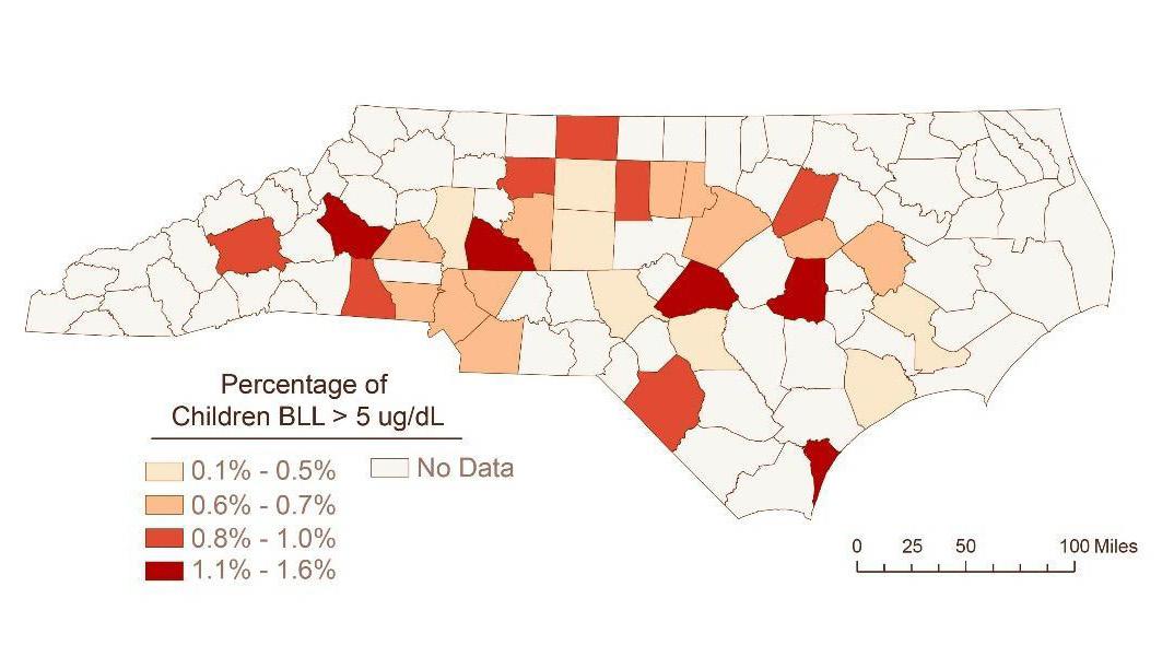
Figure 1 provides an overview of where the highest rates of lead exposure are. Wake, Guilford, Mecklenburg, Durham, and Forsyth stand out as counties with particularly high rates of childhood lead exposure.
Figure 1. Percentage of children with BLL > 5 μg/dL.
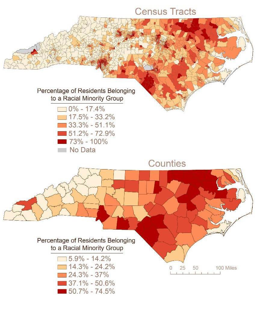
After narrowing down specific locations with relatively higher rates of elevated childhood BLLs, the map is zoomed in to better understand circumstances for specific locations based on the proportion of the minority population and the housing characteristics. This is done using the CDC’s SVI along the “Minority Percent” variable, which is the percent minority population, and
14 CAROLINA PLANNING JOURNAL
E_HH, which is the percent of the housing stock considered to be in poor quality.
RESULTS
The summary table below details the population of children under three years old, the percentage tested for blood lead levels, and the percentage who were designated as having elevated BLL, which is anything greater than 5 μg/dL for the top five worst counties in NC by percentage.
County Children <72 months of age Children tested Children with bll >5 µg/dl
Vance 3,346 312 (9.3%) 14 (4.5%)
Beaufort 2,832 348 (12.3%) 11 (3.2%)
Lee 4,600 782 (17%) 14 (1.8%)
Burke 5,268 515 (9.8%) 8 (1.6%)
Rowan 9,871 1,281 (13%) 21 (1.60%)
Table 1. County-level data on child blood lead levels greater than 5 μg/dL. Analysis conducted for all counties; however, only the top five worst were included in this table
Figures 2, 3, and 4 indicate that there is an association between demographic and housing risk factors and increased prevalence of lead in North Carolina. Firstly, there is a strong clustering between the density of poverty and increased childhood BLLs. Statistical analysis indicates that a one percent increase in the presence of poverty is associated with 3.2 percentage point increase in the percent of children with elevated BLLs. This measure is a proportion, indicating that it is not simply due to population density. Statistical analysis also indicate there to be a relationship between the percent of Black residents and the percent of children with elevated BLLs—specifically a 0.47 percentage
point increase in elevated childhood BLLs. Finally, as was expected, increased numbers of homes built pre-1980 (lead paint in homes was banned in 1978) was also associated with increased rates of elevated BLLs.
Figure 2. Population density analysis of minority percentage at state and county levels.
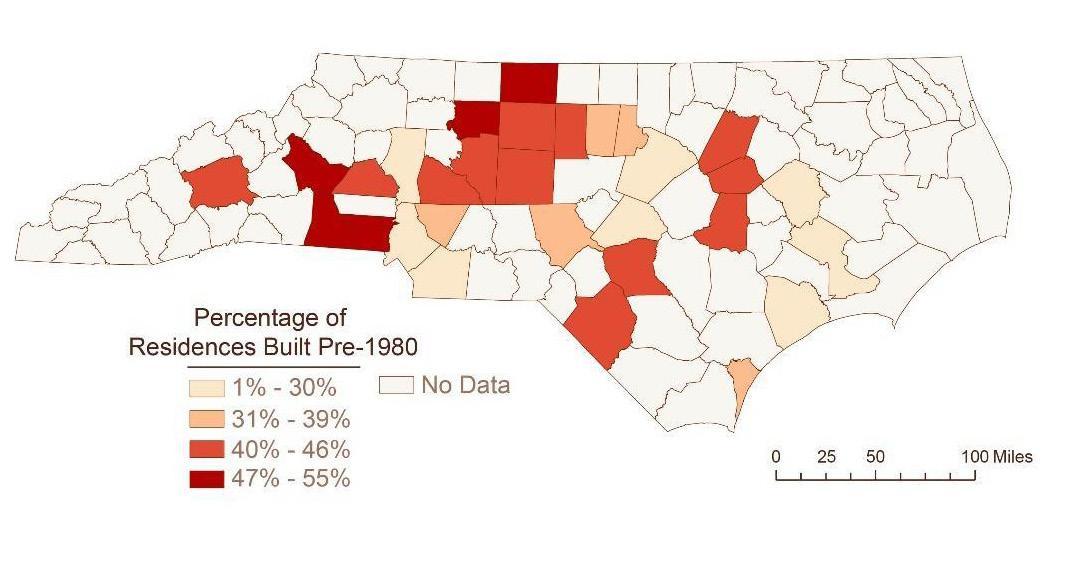
Figure 3 depicts which counties have high concentrations of older homes at higher risk of lead exposure. The statistical analysis indicates that each percentage point increase in homes built before 1980 is associated with a 2.2 percentage point increase in the percent of children with elevated BLLs.
15Planning for Healthy Cities
Figure 3. Geo-spatial analysis of homes built before 1980.
These results indicate that broadly speaking, North Carolina experiences a strong relationship between marginalized class and racial identities and living in high-risk housing environments, increasing their exposure to lead. However, the counties where these trends do not hold (specifically New Hanover and Columbus counties) indicate that there may be alternative sources of lead exposure, particularly industrial sources, that causes elevated BLLs in children.
CONCLUSION AND RECOMMENDATIONS
These results are only associations and not indicative of causality; however, consistent patterns emerge. There appears to be relatively strong relationships between demographic minorities, low-income communities, poor housing conditions, and elevated blood lead levels in children. The literature supports these findings, and the above results support that these relationships persist in North Carolina at the county and census tract levels.
Policymakers, planners, and community advocates should take these results as a call to action. Low-income, minority communities are disproportionately harmed by household lead exposure, often caused by lowquality, aging housing units. As President Biden’s implements the Build Back Better legislation, which includes provisions for lead remediation, NC and local level officials should be taking immediate action to address lead exposure in all NC communities. These interventions include targeted public relations messaging, home remediation, expanding the Section 8 Housing Choice Voucher (HCV) program, expanding BLL testing, and mandatory reporting for counties.
ACKNOWLEDGEMENTS
Cartography by Tia Francis, Digital Research Services Specialist at the University Libraries at the University of North Carolina at Chapel Hill.
16 CAROLINA PLANNING JOURNAL
REFERENCES
America’s Health Rankings, 2021. https://www. americashealthrankings.org/explore/health-ofwomen-and-children/measure/housing_leadrisk/ state/NC
Carlock, David M. 1993. Determination of the Sources of Low-Level Lead Poisoning In North Carolina Children. https://doi.org/10.17615/07b0-7e46
City of Flint, 2021. https://www.cityofflint.com/ gettheleadout/
Environmental Protection Agency, 2022. Basic Information about Lead in Drinking Water. https:// www.epa.gov/ground-water-and-drinking-water/ basic-information-about-lead-drinking-water
Kamai, Elizabeth. (2021). Lead and Children in North Carolina: Patterns of Lead Testing across the State and a Case Study of Point Sources in Forsyth County, North Carolina. Gillings School of Global Public Health, Department of Epidemiology. DOI: https://doi.org/10.17615/0sc9-v126
Kim, Dohyeong, M. Alicia Overstreet Galeano, Andrew Hull, and Marie Lynn Miranda. “A Framework for Widespread Replication of a Highly Spatially Resolved Childhood LeadExposure Risk Model.” Environmental Health Perspectives 116, no. 12 (2008): 1735–39. http://www.jstor.org/stable/25165531
Lanphear, B. P., Hornung, R., Khoury, J., Yolton, K., Baghurst, P., Bellinger, D. C., Canfield, R. L., Dietrich, K. N., Bornschein, R., Greene, T., Rothenberg, S. J., Needleman, H. L., Schnaas, L., Wasserman, G., Graziano, J., & Roberts, R. (2005). Low-level environmental lead exposure and children’s intellectual function: an international pooled analysis. Environmental health perspectives, 113(7), 894–899. https://doi.org/10.1289/ehp.7688
Leech, T. , Adams, E. , Weathers, T. , Staten, L. & Filippelli, G. (2016). Inequitable Chronic Lead Exposure. Family & Community Health, 39 (3), 151-159. doi: 10.1097/ FCH.0000000000000106.
Lewis, J. (1985). Lead Poisoning: A Historical Perspective. https://archive.epa.gov/epa/aboutepa/ lead-poisoning-historical-perspective.html
Liu J, Liu X, Wang W, McCauley L, Pinto-Martin J, Wang Y, Li L, Yan C, Rogan WJ. 2014. Blood lead levels and children’s behavioral and emotional problems: a cohort study. JAMA Pediatr; doi:10.1001/ jamapediatrics.2014.332.
Occupation & Environmental Epidemiology, N.C. Department of Health and Human Services, November 2020. https://epi.dph.ncdhhs.gov/oee/ a_z/lead.html
Sampson, R.J. & Winter, A.S. (2016). The Racial Ecology of Lead Poisoning. Du Bois Review, https://www.cambridge.org/core/journals/ du-bois-review-social-science-research-onrace/article/racial-ecology-of-lead-poisoning/ F39AF4724258606DCC1CDA369DC08707
World Health Organization. 2021. Lead Poisoning. https://www.who.int/news-room/fact-sheets/detail/ lead-poisoning-and-health
17Planning for Healthy Cities
HOW PLANNERS ADDRESS EXTREME HEAT WITH EQUITABLE RESILIENCE
Emily Gvino, MCRP, MPH / Julia Maron, MCRP
EMILY GVINO is an Associate with Clarion Associates in Chapel Hill, North Carolina. After graduating from the University of North Carolina at Chapel Hill’s Master of Public Health and Master of City and Regional Planning dual-degree program, she worked for the Belmont Forum-funded grant, Re-Energize Governance of Disaster Risk Reduction and Resilience for Sustainable Development. As an environmental planner and public health professional, her work focuses on the intersections of climate justice, disaster resilience, health equity, and environmental and land use planning.
JULIA MARON is a Climate Resilience Planner with Kleinfelder in Raleigh, North Carolina and is graduating with a master’s from the City and Regional Planning Department at the University of North Carolina at Chapel Hill in May 2022. She also worked for the Belmont Forum-funded grant, Re-Energize Governance of Disaster Risk Reduction and Resilience for Sustainable Development. As an aspiring resilience planner, she plans to work at the intersection of environmental conservation and disaster resilience, with a focus on utilizing natural and nature-based methods to address hazards.
ABSTRACT
Problem, Approach, and Findings
Extreme heat is one of the most concerning natural hazards facing cities today, forecasted to increase in frequency, duration, and intensity in the future. With close to 3.5 billion people projected to be impacted worldwide by extreme heat by 2070, it is critical that efforts focus on planning and adapting our built urban environment to reduce the risks that people will face from heat waves. A lack of data and monitoring has left uncertainty surrounding the full impact to people’s health
18 CAROLINA PLANNING JOURNAL
from extreme heat. Currently, planners are undertaking important work to understand how extreme heat disproportionately affects communities historically discriminated against in planning practices.
Implications
This article looks at how local planners and municipalities, primarily in urban communities, can best address extreme heat within the lens of equitable resilience. Planners must go beyond unenforceable comprehensive plans to zoning regulations and unified development ordinances to change and adapt to threats posed by hazards. Equitable stakeholder engagement and environmental justice must be incorporated into the process, centering those with power and those most impacted, as these people will have the most at stake.
INTRODUCTION
Climate change is a cross-cutting issue that impacts urban environments across many disciplines and sectors. Leading practitioners in public health and health research institutions have already identified climate change as the greatest threat to global public health (Choi-Schagrin 2021; Maibach et al. 2010). An unprecedented statement published by over 200 medical journals globally called for interdisciplinary action to address the social and economic determinants of health impacted by climate change (Atwoli et al. 2021)
One of the most critical and urgent threats to healthy cities is the risk of natural hazards, as climate change is altering the frequency and severity of severe weather (Masson-Delmotte et al. 2021). Climate resilience resides at the intersection between planning and health and seeks to promote healthier and more
equitable living conditions for urban residents. This intersection will become increasingly important as cities cope with acute events such as severe storms and hurricanes and longer-term impacts such as higher average temperatures, chronic flooding, and changing precipitation patterns.
Of all climate hazards, extreme heat causes the most health risks in the United States (Meerow and Keith 2021). The unusual increase in the number of deaths in a given population, termed excess mortality, is a particular concern for urban environments impacted by extreme heat (Smith 2020). Heat waves are increasing in frequency, duration, and intensity (Manaloto 2021); 2020 was the second warmest year on record globally (Bateman 2020). The Extreme Heat Resilience Alliance—a global, crosssectoral collaboration addressing urban heat challenges—estimates that extreme heat will impact more than 3.5 billion people by 2070. Of these, 1.6 billion will be residents of urban areas. Extreme heat is known as the ‘silent killer’ due to a lack of data and monitoring. There is uncertainty around how many people die from heat, which health conditions are most exacerbated by it, and whether current policies are effective in addressing heatrelated health impacts (Owen-Burge 2021) This hazard deserves particular attention given the reality that temperature warming will continue to increase for many decades, even with intensive emissions reduction (Sherman 2020).
Urban heat islands are the phenomena of higher temperatures in cities (compared to rural communities) resulting in part from the high concentrations of paved surfaces, along with limited tree canopy and green space, often seen in urban development
19Planning for Healthy Cities
(Meerow and Keith 2021; Jones, Dunn, and Balk 2021; Wilson 2020). Importantly, extreme heat is an environmental justice concern, disproportionately affecting communities that have experienced historical patterns of discrimination and disinvestment (Wilson 2020). Researchers have analyzed patterns of disinvestment and racist policies—specifically redlining—as determinants for the health impacts of extreme heat (Plumer, Popovich, and Renault 2020; Wilson 2020; Wolch, Byrne, and Newell 2014). Early practices of segregating Black and white communities, followed by redlining, caused social and environmental inequity impacting nonwhite residents in current urban forms, like less tree canopy and green space (Maller and Strengers 2011; Lawrence 2004; Grove et al. 2017). These inequities have compounded issues of access to green space, distribution of resources, urban design and investment, and other factors that comprise the built environment. Planning at the local level is integral for addressing equitable resilience and promoting adaptation. Tools like comprehensive plans as well as local zoning, codes, and ordinances can mitigate the impacts of extreme heat by planners promoting equitable resilience and locally led adaptation. Augmentation of urban vegetation and other urban design strategies can also decrease extreme heat risk at the local level. For planning strategies to remain equitable, these mechanisms must be coupled with vulnerability assessment and equity analysis, integrating public health concepts to fully understand who is being impacted and how to implement solutions.
EQUITABLE APPROACH TO RESILIENCY: INTERNATIONAL POLICY CONTEXT
Addressing the ingrained systems of injustice and inequity within social determinants of health, and the resulting vulnerability of priority populations, must underpin any resilience efforts. The concept of equitable resilience requires a transformation of current systems and mindsets about resilience, taking “into account issues of social vulnerability and differential access to power, knowledge, and resources” (Matin, Forrester, and Ensor 2018). The Resilient Nation Partnership Network, FEMA, and NOAA published the 2021 report, “Building Alliances for Equitable Resilience,” garnering key insights from diverse stakeholders on community resilience and equity (Willis et al. 2021). As the repercussions of climate change challenge our cities, establishing equitable frameworks for heat resilience will be increasingly vital.
Planners can look to several policy frameworks from the global stage for context on addressing equitable heat resilience, especially from the United Nations (UN). The 2015 Paris Agreement was a monumental step forward in this arena, mandating universal commitment to climate neutrality through multilevel, multi-stakeholder action (BerrangFord et al. 2019; Roberts 2016).
The Sendai Framework, which focuses on the health impacts of natural hazards, was adopted at the Third UN World Conference on Disaster Risk Reduction in 2015. The Sendai Framework established four priorities for action following the Paris Agreement: 1) understand disaster risk; 2) strengthen disaster risk governance to manage disaster risk; 3) invest in disaster
20 CAROLINA PLANNING JOURNAL
risk reduction for resilience; and 4) enhance disaster preparedness for effective response and to “Build Back Better” in recovery, rehabilitation, and reconstruction (United Nations Office for Disaster Risk Reduction 2021). The ambitious goals imagine a world that is safer, healthier, and more equitable by 2030: one that decreases mortality and impacts to people, reduces economic and infrastructure damages, bolsters local risk reduction strategies, improves global cooperation, and augments early warning systems (United Nations Office for Disaster Risk Reduction 2021).
In 2016, the New Urban Agenda was adopted by the UN Conference on Housing and Sustainable Urban Development (Habitat III) and endorsed by the UN General Assembly. The focus of the New Urban Agenda is “equal rights and access to the benefits and opportunities that cities can offer”, highlighting the role of subnational and local governments in accomplishing these goals. Quantitative measures are included for the transport and mobility, energy solid waste, and water/sanitation sectors. The New Urban Agenda promotes intervention mechanisms in land, housing, and revitalization policies, urban design, municipal finance, and urban governance. As such, planners have a clear, global mandate from climate experts to focus on disaster risk reduction and resilience in their work. As cities grapple with these complex challenges, health equity and stakeholder engagement must be the primary focus in implementing intersectional, inclusive, and effective solutions. Pivotal to this work is equitable stakeholder engagement, which underpins the current roles and responsibilities of planners working at the local level across
the United States. The International Institute for Environment and Development aptly describes this imperative for “local governments to shift away from ‘development as usual’—to development planning that places climate at its heart, champions bottom-up community participation and values local knowledge” (Soanes 2021a) Hundreds of governments and institutions are committed to locally-led climate adaptation, having signed on to these principles (and committed significant funding) at the UN Climate Change Conference in Glasgow (Soanes 2021b, 2021a; Owen-Burge 2021).
The Belmont Forum-funded grant project, Re-Energize Governance of Disaster Risk Reduction and Resilience for Sustainable Development , established the UNC Snow Angel Method. This novel approach to stakeholder engagement re-thinks traditional processes to invigorate locallyled resilience. The UNC Snow Angel Method combines snowball and purposive sampling methods with the idea that better-informed decisions are the result of equitable engagement that encompasses people from priority groups. This approach advocates for the greater involvement of stakeholders in decision-making, garnering more rooted community support, and improving implementation. The snowball method starts with a few defined stakeholders and asks them to identify new organizations and other contacts. While this is helpful for researchers, this method can unintentionally limit the scope of included stakeholders.
In comparison, while the UNC Snow Angel Method specifically recognizes the need to include a wide number of stakeholders, it centers those with power and those most impacted. This method is an attempt to
21Planning for Healthy Cities
prioritize the need for broad stakeholder input while simultaneously recognizing that those most impacted (or vulnerable) have the deepest stake in the issues at hand. NOAA’s National Integrated Heat Health Information System heat mapping campaign, conducted across 11 states by local organizations, is an excellent example of a community-based equitable engagement approach. During the Summer of 2021 in Durham County, North Carolina, the community-led campaign recorded and mapped heat data in Durham and Raleigh on the hottest summer days (Freid 2021; Cawley 2022). Within Durham County, the project focused on eight identified census tracts where redlining, racism, and historic inequity have resulted in marked and disproportionate health risks for people of color and lower-income community members.
The project would not be possible without an extensive network of community volunteers and local partners. To support data collection, the volunteers traversed the cities by car and bike to better understand how heat is impacting residents. The data will be integrated with community demographic information to understand social vulnerability. From a policy standpoint, this project will be integrated into the first-ever climate change chapter in the Community Health Assessment from the Partnership for a Healthy Durham. This work is also founded in Durham County’s Strategic Planning goals.
APPLICATION TO PLANNING PRACTICE
When addressing extreme heat in the context of equitable resilience, local level planners have a variety of tools at their disposal. Of course, every planner faces a complicated decision-making process prioritizing community feedback and balancing local climate change impacts, funding, resources, and capacity. Following the inspiration of the landmark Sustainable Development Code, we present a framework of “good-better-best” planning practices that can move the needle in mitigating extreme heat (Rosenbloom and Adams 2019).
COMPREHENSIVE AND CLIMATE PLANS—GOOD
In the United States, comprehensive plans are foundational for determining community goals and guiding future actions for individual jurisdictions. Generally, these planning documents look at existing conditions and issues, set goals and objectives to address the issues, determine implementation strategies, and guide future land use decision-making. Increasingly, cities and states are creating climate adaptation and resilience plans that will help stakeholders anticipate, prepare for, adapt to, and recover from the impacts of climate change (Environmental Protection Agency 2021). As with comprehensive plans, climate adaptation and resilience plans lay out strategies to address hazards and their associated risks to vulnerable groups. Many states have local or regional plans that address climate adaptation, and few have state-led adaptation plans (Georgetown Climate Center 2021). While increasingly common, climate action plans tend to focus on the reduction of greenhouse gas emissions.
22 CAROLINA PLANNING JOURNAL
Comprehensive and climate plans generally require collaborative efforts to identify current issues and offer objectives and goals. However, these planning documents often lack legally enforceable standards that ensure progress towards the desired goals. When these plans are not referenced during decision-making, they fail to reach their full potential. Therefore, we believe comprehensive and climate plans are only good when it comes to addressing extreme heat and equitable resilience.
INTEGRATED RISK ASSESSMENTS—BETTER
A better approach for municipal governments and local planners is to integrate extreme heat risk assessments with comprehensive plans or unified development ordinances. While comprehensive plans provide overall guidance through goals, policies, and programs, they lack enforceability and leave substantial discretion for how they are implemented. In contrast, unified development ordinances combine zoning regulations with other management or design regulations, providing the enforcement and implementation tools that comprehensive plans lack. By integrating extreme heat risk assessments into these documents, municipalities are armed with the “how” or “how much” behind the “why.”
The City of Baltimore’s Disaster Preparedness and Planning Project (“Disaster Plan”) was produced by the Department of Planning in 2013 and ultimately adopted in 2018. Baltimore is currently in the process of completing their Master Plan 2030, presenting a great opportunity for Baltimore to integrate the hazard risk assessment into their comprehensive plan process. The Disaster
Plan recommends increasing urban tree canopy to 40% by 2037, which would reduce the effect of extreme heat on communities. An additional recommendation is to increase green space in vacant lots, which would reduce impervious surface and provide new opportunities for shade (Center for Climate and Energy Solutions 2017)
PHYSICAL LAND USE CHANGES—BEST
The term “urban heat management” refers to proactive engagement by local governments to reduce the intensity and duration of heat exposure through tree planting, use of cooling materials, and similar activities (Stone et al. 2019). While comprehensive plans, heat action plans, and integrated risk assessments provide the foundation to mitigate extreme heat, physical land use changes through urban heat management will result in tangible health impacts for communities. As previously mentioned, lagging national and global action to reduce greenhouse gases means that extreme heat will be a regular reality, particularly for lower-income and BIPOC communities. Planners face an imperative to retrofit, redesign, and rethink the current urban environment to relieve these health impacts as quickly as possible.
To best reduce risk to extreme heat for vulnerable groups and provide equitable resilience, municipalities need to examine ordinances and zoning regulations to determine what is and is not being enforced. Related to extreme heat, these elements should be examined first: tree protection and retention, green and open space preservation, cooling pavement, and cooling roofs. For example, the City of Raleigh received a clean
23Planning for Healthy Cities
technology pavement award from NCDOT for reducing urban heat island effect and preserving pavement through titanium oxide treatments. Treated roads showed a 37% reduction in nitrous oxides—a roadway contaminant—as well as a nearly 400% improvement in the average Solar Reflective Index compared to untreated locations (Cawley 2022; Carleton 2021). This work by the City of Raleigh demonstrates how data-driven physical interventions can promote equity in green infrastructure.
The New Urban Agenda calls for two actionable changes relevant to urban heat management land use policy: 1) providing of rebates or tax credits for new development that include cool and green roofs and 2) creating an expedited permitting process for developments that meet density requirements (United Nations Conference on Housing and Sustainable Urban Development 2016). Gold-star renovations of municipally owned buildings, the Agenda suggestions, can demonstrate the feasibility of these project in local development markets. In addition, developing building retrofit incentive programs can vastly decrease heat-related illness and mortality.
Houston, Philadelphia, and Louisville have also taken action in urban heat management. Houston required cool roofing provisions in 2016 for commercial buildings, and Philadelphia passed an ordinance requiring white or reflective Energy-Star approved materials for new or renovated buildings (Center for Climate and Energy Solutions 2017). An innovative expansion of these kinds of requirements is the installation of cool pavements, which lower surface temperatures and mitigate health impacts (Center for Climate and Energy Solutions
2017). Louisville experienced a deadly heat wave in 2012 that prompted city action (Stone et al. 2019). The Center for Climate and Energy Solutions commended their multi-pronged approach, which will include a climate and health assessment, a cool roof rebate program, and cool roof installation on parking garages and park buildings. The city completed an Urban Tree Assessment and hired a forester, aiming for 45% tree canopy citywide and focusing on disinvested neighborhoods (Center for Climate and Energy Solutions 2017, Boyle 2020).
RECOMMENDATIONS FOR LOCAL PLANNERS
Local planners are key leaders in helping their communities address the challenges climate change poses to people and the environment. The planning profession works at the intersection of sectors that are critical to hazard mitigation and adaptation – land use, public health, development, and transportation. Interdisciplinary collaboration amongst these sectors is necessary for advancing equitable resilience. Based on issues identified in the comprehensive and climate plans, local planning departments can re-evaluate zoning regulations and unified development ordinances within the lens of climate change adaptation. A strategy that can be effective is overlay zoning for specific hazards or establishing a “resilience zone” overlay. This applies additional standards to the defined boundary, which can be specific to hazards like extreme heat or flooding. The hazard and resilience overlay can dictate land use regulations, permitted uses, and construction types which creates opportunities to address equitable resilience strategies. The Boston Planning &
24 CAROLINA PLANNING JOURNAL
Development Agency (BPDA) adopted the Coastal Flood Resilience Overlay District (CFROD) in October 2021 (Boston Planning & Development Agency 2021; Hughes 2021). The CFROD aims to protect portions of the City of Boston where 40 inches of sea level rise is expected in a 1% chance storm event. The CFROD implements updated Design Guidelines, new flood elevation requirements, and standards for building uses. The BPDA also added a Resilience Reviewer to advise development project alignment with climate policies, following their Climate Ready Boston plan (Boston Planning & Development Agency 2021). Similarly, the city of Norfolk, Virginia established a Coastal Resilience Overlay Zone and Upland Resilience Overlay, both of which were adopted in 2018 and requires developers to address risk reduction, stormwater management, and energy resilience through use of a flexible pointsbased system (Sharp 2021)
Local level prioritization of funding for climate action is critical. According to the International Institute of Environment and Development, less than 10% of global climate funds are committed to climate action at the local level (Soanes 2021a). This lack of funding leads to critical gaps in action for communities most impacted by extreme weather and climate events. We recommend re-tooling planning finance mechanisms to fund urban heat management strategies. For example, the New Urban Agenda highlights tax increment financing and special assessment districts as land value capture tools for climate resilience (Center for Climate and Energy Solutions 2017)
Additionally, stakeholder engagement should center those with power and those who are most impacted, as those most vulnerable will likely have the deepest stake in the issue. Community involvement around extreme heat risk reduction and comprehensive planning is critical, and efforts must ensure that the appropriate people are fully brought into the process. Stakeholder engagement activities may look like in-person workshops, virtual meetings held at varied times and utilizing the UNC Snow Angel Method to reach vulnerable groups.
CONCLUSION
Planners have the tools and ability to help communities increase their resilience to extreme heat. Zoning regulations, unified development ordinances, and financing incentives should be used—in tandem with equitable stakeholder engagement—to make changes to land use that ultimately work well in alleviating heat in urban areas.
25Planning for Healthy Cities
REFERENCES
Atwoli, Lukoye, Abdullah H. Baqui, Thomas Benfield, Raffaella Bosurgi, Fiona Godlee, Stephen Hancocks, Richard Horton, et al. 2021. “Call for Emergency Action to Limit Global Temperature Increases, Restore Biodiversity, and Protect Health.” The New England Journal of Medicine, September. https://doi. org/10.1056/NEJMe2113200.
Bateman, John. 2021. “2020 Was Earth’s 2nd-Hottest Year, Just behind 2016.” National Oceanic and Atmospheric Administration. January 14, 2021. https://www.noaa.gov/news/2020-was-earth-s-2ndhottest-year-just-behind-2016
Berrang-Ford, Lea, Robbert Biesbroek, James D. Ford, Alexandra Lesnikowski, Andrew Tanabe, Frances M. Wang, Chen Chen, et al. 2019. “Tracking Global Climate Change Adaptation among Governments.” Nature Climate Change 9 (6): 440–49. https://doi. org/10.1038/s41558-019-0490-0.
Boston Planning & Development Agency. 2021. “Flood Resiliency Building Guidelines & Zoning Overlay District.” Boston Planning & Development Agency. September 2021. https://www.bostonplans.org/ planning/planning-initiatives/flood-resiliencybuilding-guidelines-zoning-over.
Boyle, John. 2020. “Louisville Group Works To Replenish Urban Tree Canopy.” WFPL News Louisville, December 29, 2020.
Carleton, Audrey. 2021. “Cities Are Spraying Asphalt With This Chemical to Cool Urban Heat Islands.” Vice, June 30, 2021.
Cawley, Max. 2022. “Raleigh/Durham HeatWatch UHI Data Release.” presented at the Museum of Life + Science, February 3.
Center for Climate and Energy Solutions. 2017. “Resilience Strategies for Extreme Heat.” Arlington, Virginia: Center for Climate and Energy Solutions. https://www.c2es.org/wp-content/uploads/2017/11/ resilience-strategies-for-extreme-heat.pdf
Choi-Schagrin, Winston. 2021. “Medical Journals Call Climate Change the ‘Greatest Threat to Global Public Health.’” The New York Times, September 7, 2021.
Environmental Protection Agency. 2021. “Climate Adaptation.” United States Environmental Protection Agency. October 7, 2021. https://www. epa.gov/climate-adaptation.
Freid, Tobin. 2021. “Durham County Joins NOAA, City of Raleigh and Community Partners to Map Urban Heat Islands.” Durham County News, May 13, 2021. https://www.dconc.gov/Home/Components/News/ News/8291/.
Georgetown Climate Center. 2021. “State and Local Adaptation Plans.” Georgetown Climate Center. November 4, 2021. https://www.georgetownclimate. org/adaptation/plans.html.
Grove, Morgan, Laura Ogden, Steward Pickett, Chris Boone, Geoff Buckley, Dexter H. Locke, Charlie Lord, and Billy Hall. 2017. “The Legacy Effect: Understanding How Segregation and Environmental Injustice Unfold over Time in Baltimore.” Annals of the American Association of Geographers 108 (2): 1–14. https://doi.org/10.1080/2 4694452.2017.1365585.
Hughes, Liz. 2021. “BPDA Votes to Advance City’s Coastal Flood Resilience Zoning Overlay District.” Boston Agent Magazine, September 20, 2021. Jones, Bryan, Gillian Dunn, and Deborah Balk. 2021. “Extreme Heat Related Mortality: Spatial Patterns and Determinants in the United States, 1979–2011.” Spatial Demography 9 (1): 107–29. https://doi. org/10.1007/s40980-021-00079-6.
Lawrence, Roderick J. 2004. “Housing and Health: From Interdisciplinary Principles to Transdisciplinary Research and Practice.” Futures 36 (4): 487–502. https://doi.org/10.1016/j.futures.2003.10.001.
Maibach, Edward W, Matthew Nisbet, Paula Baldwin, Karen Akerlof, and Guoqing Diao. 2010. “Reframing Climate Change as a Public Health Issue: An Exploratory Study of Public Reactions.” BMC Public Health 10 (June): 299. https://doi.org/10.1186/14712458-10-299.
Maller, Cecily J, and Yolande Strengers. 2011. “Housing, Heat Stress and Health in a Changing Climate: Promoting the Adaptive Capacity of Vulnerable Households, a Suggested Way Forward.” Health Promotion International 26 (4): 492–98. https://doi. org/10.1093/heapro/dar003.
Manaloto, Jen. 2021. “Extreme Heat Resilience Alliance.” Atlantic Council; Adrienne Arsht-Rockefeller Foundation Resilience Center at the Atlantic Council. https://uploads-ssl.webflow.
Masson-Delmotte, V, P Zhai, A Pirani, S L Connors, C Péan, S Berger, N Caud, et al., eds. 2021. “Climate Change 2021: The Physical Science Basis. Contribution of Working Group I to the Sixth Assessment Report of the Intergovernmental Panel on Climate Change.” Cambridge University Press. https://www.ipcc.ch/report/ar6/wg1/#SPM.
Matin, Nilufar, John Forrester, and Jonathan Ensor. 2018. “What Is Equitable Resilience?” World Development 109 (September): 197–205. https://doi. org/10.1016/j.worlddev.2018.04.020.
Meerow, Sara, and Ladd Keith. 2021. “Planning for Extreme Heat: A National Survey of U.S. Planners.” Journal of the American Planning Association,
26 CAROLINA PLANNING JOURNAL
December, 1–16. https://doi.org/10.1080/01944363.20 21.1977682.
Owen-Burge, Charlotte. 2021. “‘It Is in Cities Where the Battle against Climate Change Will Be Defined.’” UNFCCC Race to Resilience. November 11, 2021. https://racetozero.unfccc.int/it-is-in-cities-wherethe-battle-against-climate-change-will-be-defined/.
Plumer, Brad, Nadja Popovich, and Marion Renault. 2020. “How Racist Urban Planning Left Some Neighborhoods to Swelter.” The New York Times, August 26, 2020. https://www.nytimes. com/2020/08/26/climate/racist-urban-planning. html?auth=login-email&login=email.
Roberts, Debra. 2016. “The New Climate Calculus: 1.5°C = Paris Agreement, Cities, Local Government, Science and Champions (Plsc2 ).” Urbanisation 1 (2): 71–78. https://doi.org/10.1177/2455747116672474.
Rosenbloom, Johnathan, and Bradley Adams, eds. 2019. “Sustainable Development Code.” Sustainable Development Code. https://sustainablecitycode.org/ about/
Sharp, Jeremy. 2021. “Zoning Ordinance Overhauled to Increase Community Resilience to Flooding.” NOAA Office for Coastal Management. April 21, 2021. https://coast.noaa.gov/digitalcoast/training/norfolkzoning-ordinance.html
Sherman, Amy. 2020. “The Heat Is On.” Planning Magazine, September. https://www.planning.org/ planning/2020/aug/the-heat-is-on/.
Smith, Adam B. 2020. “2010-2019: A Landmark Decade of U.S. Billion-Dollar Weather and Climate Disasters.” NOAA Climate.Gov. January 8, 2020. https://www. climate.gov/news-features/blogs/beyond-data/20102019-landmark-decade-us-billion-dollar-weatherand-climate.
Soanes, Marek. 2021a. “Principles for Locally-Led Adaptation.” International Institute for Environment and Development. November 2021. https://www. iied.org/principles-for-locally-led-adaptation.
———. 2021b. “Significant New Support for Locally-Led Adaptation Principles.” International Institute for Environment and Development. November 8, 2021. https://www.iied.org/significant-new-support-forlocally-led-adaptation-principles.
Stone, Brian, Kevin Lanza, Evan Mallen, Jason Vargo, and Armistead Russell. 2019. “Urban Heat Management in Louisville, Kentucky: A Framework for Climate Adaptation Planning.” Journal of Planning Education and Research, October, 0739456X1987921. https://doi. org/10.1177/0739456X19879214.
United Nations Conference on Housing and Sustainable Urban Development. 2016. “New Urban Agenda.” United Nations Conference on Housing and Sustainable Urban Development (Habitat III).
United Nations Office for Disaster Risk Reduction. 2021. “What Is the Sendai Framework?” United Nations Office for Disaster Risk Reduction. December 2021. https://www.undrr.org/ implementing-sendai-framework/what-sendaiframework.
Willis, Chauncia, Monica Sanders, Jo Linda Johnson, S. Atyia Martin, Valerie Novack, Anna Marandi, Jake White, and Nikki Cooley. 2021. “Building Alliances for Equitable Resilience: Advancing Equitable Resilience through Partnerships and Diverse Perspectives.” United States Federal Emergency Management Agency. https://www.fema.gov/sites/ default/files/documents/fema_rnpn_buildingalliances-for-equitable-resilience.pdf.
Wilson, Bev. 2020. “Urban Heat Management and the Legacy of Redlining.” Journal of the American Planning Association, May, 1–15. https://doi.org/10.108 0/01944363.2020.1759127.
Wolch, Jennifer R., Jason Byrne, and Joshua P. Newell. 2014. “Urban Green Space, Public Health, and Environmental Justice: The Challenge of Making Cities ‘Just Green Enough.’” Landscape and Urban Planning 125 (May): 234–44. https://doi.org/10.1016/j. landurbplan.2014.01.017.
27Planning for Healthy Cities
EXPANDING CRASH DATA ANALYSIS Defining Crash Risk for Non-Motorized Users
Daniel Capparella / Jessica Hill, AICP, PMP / Ashleigh Glasscock
DANIEL CAPPARELLA has been with GNRC since August of 2019. He currently serves as the Active Transportation Planner and coordinates the bike and pedestrian elements of transportation planning carried out by the organization. Prior to joining GNRC, he worked at the Los Angeles Community Action Network, a homelessness advocacy organization in the Skid Row Community and greater Los Angeles metropolitan area. He earned a Bachelor of Arts in urban and environmental policy from Occidental College.
JESSICA HILL serves as the community and regional planning director for the Greater Nashville Regional Council. With more than 14 years of experience in local and regional government, Jessica excels at building partnerships across government and business sectors. She holds a Master of City and Regional Planning from the University of North Carolina at Chapel Hill and Master of Business Administration from Wake Forest University.
ASHLEIGH GLASSCOCK has been with GNRC since December 2018. She serves as a senior research analyst, working to assess a variety of datasets, create maps, data visualizations, and perform data analysis in support of GNRC’s programs. She helps support programs related to demographics, development, infrastructure, natural resources, and quality of life. Prior to joining GNRC, she attended East Tennessee State University where she received her master’s degree in geoscience with a concentration in geospatial analysis.
28 CAROLINA PLANNING JOURNAL
ABSTRACT
Problem Approach and Finding
The Nashville region has a troubling trend. Since 2015, pedestrian fatalities have almost doubled. While serious motorized injuries were nearly cut in half, non-motorized serious injuries remained constant. These trends have worsened during the COVID-19 pandemic.
With the recent surge in active transportation activity in the region and limited funding available for bicycle and pedestrian improvements, a more systemic and focused approach must be utilized to identify and prioritize solutions for improving safety for bicyclists and pedestrians.
This article presents a non-motorized risk index that provides a system-level tool to proactively identify areas with unsafe nonmotorized conditions to better guide planning and prioritize solutions for bicyclists and pedestrians.
Implications
By demonstrating the ability to identify unsafe conditions for bicyclists and pedestrians across the Nashville region’s transportation network beyond a hot spot analysis, this index can help inform future investments that improve safety for all users of the transportation network and provide a framework to expand areas considered for non-motorized safety improvements.
INTRODUCTION
The built environment, which includes the transportation network that facilitates movement and mobility, is a foundation of community health. The transportation network is intended to accommodate multiple transportation modes, but traditional roadway design inequitably favors vehicle throughput over non-motorized needs.
In 2019, 6,205 pedestrians were killed in traffic crashes in the United States. (USDOT National Highway Traffic Safety Administration 2020) That is about one death every 85 minutes. In the same year, 846 bicyclists were killed in traffic crashes in the United States. (USDOT National Highway Traffic Safety Administration 2020) Similar to national trends, the Nashville region is experiencing a troubling trend for non-motorized safety. Since 2015, pedestrian fatalities have almost doubled and while serious motorized injuries were almost cut in half, non-motorized serious injuries remained constant. These trends have worsened during the COVID-19 pandemic. Data from the Tennessee Department of Safety reveals that 2020 proved to be the worst year on record as pedestrian fatalities continue to rise even with less cars on the road. (Tennessee Highway Patrol n.d.) With the recent surge in active transportation activity in the region due to COVID-19 related behavior patterns, combined with limited funding available for bicycle and pedestrian improvements, it is imperative that a more systemic and focused approach be utilized to identify and prioritize solutions to improve safety for bicyclists and pedestrians.
29Planning for Healthy Cities
BACKGROUND
Crash data has traditionally been used to identify dangerous areas for bicyclists and pedestrians and to make investments in safety improvements through location specific crash analyses or hot-spot analyses. Yet, relying solely on prior crashes is limiting because it does not capture all areas that are unsafe for non-motorized users. Given that bicyclists and pedestrians often avoid areas without facilities or suitable conditions, there are unsafe locations not represented through a traditional crash analysis. To better understand the factors that result in nonmotorized crashes in the Nashville region, the Greater Nashville Regional Council (GNRC) developed a non-motorized risk index to systematically identify unsafe locations for bicyclists and pedestrians.
GNRC is the federally designated metropolitan planning organization (MPO) for the Nashville region and is responsible for investing in transportation improvements, preparing, and maintaining a long-range transportation plan, and planning and programming federal, state, and local funds for transportation projects and operations. Every five years GNRC updates the Regional Transportation Plan (RTP) to account for shifts in national policy, local community issues and concerns, travel behaviors, advancements in technologies, and fluctuations in funding availability. (The Greater Nashville Regional Council 2021)
In 2019, GNRC began the process of updating the 2045 RTP and identified that prior RTPs had limited investment for bicycle and pedestrian infrastructure. An increase in bicycle and pedestrian fatalities and population and shifts in lifestyle preferences for more walkable communities led to a
more comprehensive way to identify and prioritize areas for non-motorized safety improvements. The purpose was to develop a tool for prioritizing areas for investment in non-motorized safety across the region.
The non-motorized risk index aims to capture unsafe areas (beyond where crashes occur) at the system level based on an analysis of crash risk factors related to the built environment, common destinations, and travel behavior. The index identifies areas where the odds of non-motorized crashes occurring are disproportionately high. The index can help proactively identify locations with unsafe non-motorized conditions to better guide safety planning and improvements in the Nashville region through a rough system-level approach.
OVERVIEW OF THE DEVELOPMENT OF NONMOTORIZED RISK INDEX
The index was developed through a set of five steps. Each step includes a corresponding question that is answered by the step below. While each step answers a prompt question, the index includes the following five steps to drill down to a system level to understand what increases crash risk across the entire region, not only in areas where crashes have occurred. Figure 1 details the index development process starting with the baseline: the regional hot-spot analysis.
HOT-SPOT ANALYSIS BASELINE
The baseline of this index stems from a traditional hot-spot analysis, shown in Figure 2 below, which identified high-crash areas based on prior bicycle and pedestrian crash history between 2015 and 2019 across the
30 CAROLINA PLANNING JOURNAL
Baseline Hot-Spot Analysis
Where have crashes occurred in the region?
The baseline of this index stems from a traditional hot-spot analysis, which identifies high-crash areas based on prior bicycle and pedestrian crash history between 2015 and 2019 across the region.
Step 1 Identify common characteristics
What do areas with the most crashes have in common?
To better understand what characteristics are present at high-crash areas, a sample of hot-spot locations were selected to observe common characteristics associated with bicycle and pedestrian crashes.
Step 2
Identify risk factors
Step 3
Analyze risk factors
Step 4
Establish factor weights
Can we quantify those characteristics with available data sets?
Next, common characteristics were identified that could be quantified through available data sets, resulting in eleven risk factors. The risk factors were sorted into groups based on their relationship to the built environment, common destinations, and travel behavior.
Step 5
Score index
How does each factor relate to bike/pedestrian crashes?
Eleven risk factors were analyzed to determine trends in non-motorized crashes. The crash risk factor analysis provided insight into the significance of bicycle and pedestrian crashes within each risk factor.
How important is each risk factor to overall bike/ped crash risk?
To capture how important each factor is to overall bicycle and pedestrian crash risk, a weighting was applied to the factors based on the proportion of roadway mileage to non-motorized crashes associated with each factor category. The factor weights captured where bicycle and pedestrian crashes are disproportionately high.
Where are the odds of bike/ped crashes occurring disproportionately high?
To display non-motorized risk at the regional level, a composite score was developed that was made up of the sum of all crash risk factor weights and scaled between low risk to high risk. The non-motorized risk index is displayed on the regional map ranging from low risk indicated in blue to high risk indicated in red.
31Planning for Healthy Cities
Figure 1: Overview of the Index Development Process
region. This step of the analysis was conducted for the update to the RTP and used to inform regional project evaluation. While the hotspot analysis indicates areas that are unsafe based on past crashes, it does not capture all unsafe areas across the region, including those that have not experienced crashes. To better understand factors that may be contributing to crashes, staff examined common characteristics of those locations.
with them are significant because they represent roadway design elements, common destinations where pedestrians and bicyclists typically frequent, and travel behavior that increase exposure of pedestrians and bicyclists to motor vehicles across the network, which creates the foundation for a more in-depth analysis to identify factors that increase the risk for a non-motorized crash to occur.
Step 2: Identifying Risk Factors
Common characteristics of crash locations were identified that could be quantified through available datasets, resulting in eleven risk factors. The risk factors were sorted into groups based on their relationship to the built environment, common destinations, and travel behavior.
Step 3: Analyzing Crash Risk Factors
Figure 2: Non-Motorized Crash Hot-spots 2015–2019 (TITAN Database)
Step 1: Identification of Common Characteristics
To better understand what characteristics are present at high-crash areas, a sample of ten hot-spot locations, five for pedestrians and five for bicyclists, were reviewed to observe common characteristics associated with bicycle and pedestrian crashes. These locations and the characteristics associated
Each of the eleven risk factors were analyzed to determine trends in non-motorized crashes. For example, vulnerable populations, which is one of the risk factors, account for a minority of the region’s population. The analysis found that six of the nine vulnerable populations, despite being a minority of the total population, account for a disproportionally high percentage of non-motorized crashes. The crash risk factor analysis established a better understanding of the significance of bicycle and pedestrian risk factors. Figure 3 identifies the crash risk factors used to develop this index, the groupings associated with those factors, as well as the significance of each risk factor in relation to bicycle and pedestrian crashes.

32 CAROLINA PLANNING JOURNAL
Crash risk factor grouping
Common characteristics Crash risk factor
Number of travel lanes
Significance of risk factor (risk)
(Bike/pedestrian crashes)
Occur disproportionately on 4-lane roadways.
Roadway speed limit
Built Environment
Design elements of the roadway
Functional classification
Occur disproportionately on roadways with speed limits between 25–45mph.
Occur disproportionately on urban arterials and collector roadways.
Proximity to traffic signals
Proximity to transit stops
Occur disproportionately within 500 feet of a signalized intersection.
Occur disproportionately within 500 feet of a transit stop.
Common Destinations
Facilities and places nonmotorized users typically frequent
Proximity to schools
Occur disproportionately between 0.25 And 0.5 miles required from a school, i.e., just outside of the school zone area (0.25 miles).
Proximity to sidewalks
Occur disproportionately within 500 feet of a sidewalk.
Proximity to bicycle facilities
Traffic volume level
Travel Behavior
Behavior of motorized users and area demographics
Congestion level
Occur disproportionately within 500 feet of a bicycle facility.
Occur disproportionately on roadways with volumes between 10,000–40,000.
Occur disproportionately on roadways with moderate congestion.
Degrees of vulnerability
Occur disproportionately in areas with above average vulnerable populations.
33Planning for Healthy Cities
Figure 3: Summary of Crash Risk Factors
Step 4: Establishing Factor Weights
To establish the impact of each crash risk factor, weighting was applied based on the proportion of roadway mileage to nonmotorized crashes associated with each crash risk factor category, or the percentage of roadway infrastructure divided by the percentage of historic crash occurrence. This was then normalized and calculated on a scale of 0 to 100. Figure 4 illustrates the crash analysis and weights for each factor, sorted by grouping.
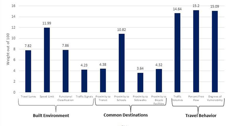
Step 5: Risk Index Scoring

To illustrate non-motorized risk at the regional level, a composite score was generated that was comprised of the sum of all crash risk factor weights and scaled between low to high risk. The scaled risk (out of 100) is made up of each risk factor’s weight added together. The risk factor weights were assigned to the region’s roadway network as illustrated in Figure 6 to identify the risk for nonmotorized crashes in the network. This is not a predictive model, but rather an illustration
of areas where there is a disproportionally high or low risk of bicycle and pedestrian crashes occurring.
CONCLUSION
Transportation planners have an essential role in building healthy communities, especially at the regional transportation level where federal and state funds are programmed. There is an increased focus on reducing bicycle and pedestrian fatalities and ensuring equitable investment in communities.
A systemic approach to analyze nonmotorized crashes can help transportation agencies and practitioners identify and prioritize high-risk areas for non-motorized safety improvements. This risk index can be useful for transportation agency staff as they update their safety improvement programs, bicycle and pedestrian planning, and prioritize current and future projects. For example, to prioritize funding for bicycle and pedestrian improvements, transportation agencies and local governments can use this
34 CAROLINA PLANNING JOURNAL
Figure 4: Risk Index Weighting Difference by Factor
index to identify areas where there is high risk for a bicycle and pedestrian crash to occur, ultimately strengthening the argument for improvements in those areas. Moreover, this index provides the ability to quantify planning interventions pre- and post-treatment. Thus, providing further evidence for the successes of proposed programs.
Though this is not a predictive model, the non-motorized risk index can provide a comprehensive look at unsafe areas and where there may be demand for walking and biking when used in-tandem with other non-motorized datasets, such as Latent Demand, which shows where future demand for walking and bicycling is low, medium, and high across the region.
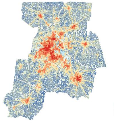
REFERENCES
Tennessee Highway Patrol. n.d. “TITAN - Tennessee’s Integrated Traffic Analysis Network.” TN Department of Safety & Homeland Security. Accessed January 2022. https://www.tn.gov/safety/ stats/titan.html

The Greater Nashville Regional Council. 2021. “Middle Tennessee Connected: Regional Transportation Plan 2021–2045.” GNRC. February 17. Accessed March 11, 2022. https://www.gnrc.org/194/RegionalTransportation-Plan
USDOT National Highway Traffic Safety Administration. 2020. “Traffic Safety Facts.” NHTSA. December. Accessed November 2021. https://crashstats.nhtsa.dot.gov/Api/Public/ ViewPublication/813060
High
Moderate
Low
35Planning for Healthy Cities
Figure 6: Non-Motorized Risk Index Map for Nashville Region MPO
risk
risk
risk
CATCHING HEALTH MESSAGING! THE TRANSLATIONAL ROLE CULTURAL INSTITUTIONS PLAY IN CITIES
Rebecca F. Kemper, Ph.D. / Frederic Bertley, Ph.D. / Joseph Wisne
DR. REBECCA F. KEMPER’S research is concerned with the intersections of urban studies, technology, and cultural sites. She is a researcher at the Center of Science and Industry (COSI) Museum and co-founder of the Latino & Latina Engineering Graduate Student Association in Columbus, Ohio. Dr. Kemper has taken courses at Columbia University and Ohio State University, holding degrees in city planning, architecture, and psychology. Her work has been featured within The Royal Society, Journal of Urban Affairs, Columbus and Dayton African American News Journal, and Technological Horizons in Education
DR. FREDERIC BERTLEY is the President and CEO of The Center of Science and Industry (COSI). Bertley graduated from McGill University, where he studied physiology, mathematics, the history of science, and earned a PhD in immunology. Bertley has worked internationally in preventative medicine and vaccines in Haiti, the Sudan, and the Canadian Arctic. Dr. Bertley’s background also includes collaboration on educational and science projects in Egypt, Paraguay, Senegal, and the Caribbean. He is the founder and led the creation of the following programs: The Color of Science, QED with Dr. B, and Dr. B in 3. He has keynoted and has been an invited speaker at several distinguished institutions including The United Nations, The White House, and the National Academy of Sciences.
JOSEPH WISNE is a 30-year veteran of the museum field, specializing in conceptual planning, interactive exhibit design, and business operations for museums, science centers, children’s museums, and branded attractions. Wisne founded Roto Group, which has since grown to one of the largest exhibition design firms in North America. Since its inception in 2004, Joseph has led Roto’s master planning, design, engineering, and production for more than fifteen new museums from the ground up. Joseph has authorship on over 200 major exhibition and attraction projects. His contributions to renowned exhibitions are on display at the Smithsonian’s National Museum of American History, the Northern Virginia Science Center, Denver Museum of Nature and Science, and many more. Wisne was recently named one of Blooloop’s 50 Museum Influencers 2021 from around the world.
36 CAROLINA PLANNING JOURNAL
ABSTRACT
During the SARS-CoV-2 pandemic, cities have struggled to manage stakeholders’ understanding of the evolving – and sometimes conflicting—public health mandates. Science communication experts have identified key issues regarding pandemics, whereby it is necessary to quickly convert successive, highly technical medical research findings into protective health advisories (Bostrom et al. 2020; Menon, 2008; Ruckelshaus 1983). The rapid conversion of emergent, advanced medical findings to patient-level effective communication for disease treatment is a translational research framework that seeks to bridge scientific understanding and needed public health communication strategies; this is commonly referred to as “bench-to-bedside” communication (Science Careers Staff, 2011; Woolf, 2008a; Woolf, 2008b).
Pandemics require a high level of buy-in from a city’s various stakeholders for advisory effectiveness (Davis et al 2020). Public health officials cannot design or implement public health advisories to novel pathogens without gathering information about a (potential) mitigation strategy’s (1) implementation cost, (2) potential public uptake, and (3) potential efficacy (i.e., advisory effectiveness). However, if the translation of emergent scientific knowledge is incorrect, individuals will stop complying with mandates out a combination of confusion, fear, and frustration (Kreps & Kriner 2020; Löfstedt et al 1999).
There is a need for trusted, urban institutions to help translate advisories to the public. Cultural institutions are a trusted resource and are connected to various city stakeholders. The following research takes a critical look at
how cities can use their cultural institutions as trusted community institutions to help effectively translate emergent scientific understanding of the pandemic and better transmit epidemic-related public health advisories to city residents (Robie & Krishnamurthi, 2020). This manuscript uses the “bench-to-bedside” scientific communication framework to provide planners with an understanding of how to use cultural institutions as a public health resource. We provide examples of this practice from Columbus, Ohio. Additionally, we briefly discuss ways to overcome some cultural institutions’ problematic legacies; this commentary is to assist planners with how to best mitigate harm during a pandemic.
KEYWORDS
pandemic, bench-to-bedside, translational research framework, cultural institutions, trust
INTRODUCTION
Pandemics require city-level disease information and public understanding to control the spread of the pathogen (Lai et al 2020). However, in the beginning of a pandemic the mode of transmission is often unknown. While scientific understanding of the pathogen’s transmission is at first nascent, there is still a need to create public health advisory content and make educated guesses as to whom vulnerable sub-populations (e.g., seniors) will be in advance of scientific discoveries (Danziger et al., 1997).
In response to the SARS-CoV-2 pandemic, the 2021 Science Public Engagement Partnership (SciPep) summit focused on the relationship between scientific discovery and effective communication to the public. The summit
37Planning for Healthy Cities
workshops focused on understanding the layers within the term science. Layers of definition as they relate to the term “science” include an idealized methodology for knowledge-generation, a collection of oftendisparate knowledges from ongoing basic and applied research, as well as the public’s characterization of scientists as experts. Each of these layers has a need to transmit and translate knowledge.
Epidemics create a timeline whereby needed public health protocols must be created alongside scientific “bench” findings, and it is here that a wicked problem arises. A misstep within communicated public health advisories will fundamentally alter public trust, create a misallocation of precious resources, and increase disease spread and mortality (Freudenberg et al 2006; Menon 2008; Moura e Sá Patrícia et al. 2020; Yichtel 1998). Ineffective public health communication is not just the dissemination of incorrect protocols; it also includes causing systemic misunderstanding of an outbreak across stakeholders or accidentally conjuring up mass distrust and fear within the public towards experts. Complicating matters, effective public health mandates (e.g., lockdowns) tend to disembody people from their everyday routines. The resulting isolation can complicate the translation of public health advisories and emergent understandings of the virus (Hampton, 2021; Raaper & Brown 2020; Saptorini 2021). The translational research framework is often referred to as a pipeline of “bench-to-bedside”, whereby technical medical scientific findings are carried over into effective treatment of a disease (Science Careers Staff, 2011; Woolf, 2008a; Woolf, 2008b). Pandemics hasten the need for such “bench-to-bedside” translations
but also wreak havoc upon traditional scientific information flows.
Cities and Trusted Information People often defer to information sources they have an affinity for when faced with elevated levels of uncertainty and stress (Davis, & Bjørkdahl, 2019; Vaughan & Tinker 2009). During a pandemic, cities need to be able to connect to evolving public health advisories as scientific understanding of the pathogen advances. Despite their importance, evolving public health advisories can become a source of further uncertainty. The communication needs in terms of required volume, relevancy, ongoing translation of risk and risk mitigation behaviors, and maintaining public trust may be greater than any one city’s administrative capacity (Kemper, 2020).
Cities regularly utilize their cultural and anchor institutions to connect with the public on complex topics that are difficult to communicate. Cultural institutions exist in the public sphere—not only as being rooted in the geography of place—but also within the social network of the city (Barrett, 2011; Erikson, 2021; Lind, 2013). Museums—particularly science museums and centers—can play an important role in the public sphere by communicating pandemic-related information to the public. Cultural institutions can mitigate translational needs under pandemic conditions, as they are often well-identified, already-trusted institutions within their cities (Institute of Museum and Library Services 2008).
Prior to the SARS-CoV-2 pandemic, museums across the United States were involved in issues relating to their communities’ education and health. The American Alliance of Museums report “Museums on Call: How Museums Are Addressing Health Issues”
38 CAROLINA PLANNING JOURNAL
(2018) gave a pre-pandemic image of how many American museums were already assisting with public health (and healthcare) literacy. Many museums had the capacity to reach people remotely; during the SARSCoV-2 outbreak, museums shifted rapidly to digital forms of engagement with their audiences by supporting public health mandates through direct messaging, translating scientific concepts to the public, or simply providing needed leisure and childhood educational activities (Kahn 2020). Additionally, museum collections can be useful in understanding pandemics, as archives can hold useful scientific communication precedents (and mistakes), societal reactions and making meaning from prior epidemics, as well as useful specimen collections for disease research (Coletta at al. 2021; Oxford 2000; Reznick & Koyle 2020; Serlin 2021; Suarez & Tsutsui 2004). Museums and other cultural institutions have also helped with public health outreach by translating medical knowledge to the public, serving as vaccination sites, and providing ongoing societal context for diseases (American Alliance of Museums 2018). Next, we move to the bench-to-bedside science translation framework that museums can be use in the face of a pandemic.
BENCH-TO-BEDSIDE KNOWLEDGE—WHO CAN TRANSLATE? WHO IS TRUSTED?
Translating ongoing scientific findings to the public for personal decision making is a particular need within the medical fields. The phrase “bench-to-bedside” refers to a form of translational scientific communication whereby basic research
findings are translated for public policy purposes, public communication, and for individual (oftentimes patient) decisionmaking (Woolf, 2008). M.D. and medical Ph.D. programs are now including benchto-bedside translational medicine in their curricula, as medical professions need to know that a difficult communications gap exists between medicine and the lay public (Kuehn, 2006). However, this gap has not been fully addressed by medicine, despite many efforts and an increasing awareness that public health messages must be both accurate and relevant to the people receiving these messages (Olsen, 2021). Cultural institutions are well-versed in translating esoteric information into culturally relevant experiences that can change the public’s perspective on a variety of topics, including public health (Fujimura, 1992; Harahap et al., 2021; Charlson et al., 2015).
CASE STUDIES FOR CHANGING MINDS: THE COSI SCIENCE MUSEUM IN COLUMBUS, OHIO AND PROJECT VACCINE, OUR BEST DEFENSE, MUSEUM OF SCIENCE IN BOSTON, MASSACHUSETTS
Science museums and centers have taken up the challenge of exposing the public to scientific breakthroughs from basic research; the current SARS-CoV-2 pandemic has seen cities partner with cultural institutions and media outlets to help the public understand the evolving understanding of this pathogen. We move now to discussing a case study example of this partnership from Columbus, Ohio and Boston, Massachusetts.
39Planning for Healthy Cities
COSI Science Museum, Columbus, Ohio
As the SARS-CoV-2 pandemic hit central Ohio in March 2020, lockdowns were ordered by Governor Mike DeWine and supported by Columbus major Andrew Ginther. Rapid changes in public health advisories emerged during this period from the federal government and had to be rapidly translated to Ohio’s urban centers, which were being hit the hardest during the early days of the pandemic. The Center of Science and Industry (COSI) is located in the capital city of Columbus, Ohio; it is a longstanding science museum in the city and a prominent member of the Association of Science and Technology Centers. COSI moved to partner with public broadcasting station WOSU media to produce and disseminate science information series that included full episodes relating to pandemic and pandemic-related topics (e.g., vaccines). The two series that emerged were Q.E.D. with Dr. B and Dr. B in 3, with episodes being dedicated to topics such as genetic codes of viruses, viral replication, variation and spread, and heard immunity. These media products were broadcasted on primetime and were also available on the WOSU website.
Project Vaccine, Our Best Defense, Museum of Science, Boston, Massachusetts
As American society settled into a protracted pandemic experience, the need for basic education about the virus transformed into a complex and ever-shifting debate across governmental, healthcare, business and media communication channels regarding the urgency and efficacy of newly available vaccines. These debates were heavily contextualized both by previous political and cultural divides concerning the severity of the
crisis and by prior deep-seated beliefs and misconceptions regarding vaccines in general. As institutions of high public trust museums became one of the few broadly accessible resources in many communities to provide a non-partisan voice (American Alliance of Museums, 2021).
Responding to the challenge, the Museum of Science (Boston) designed and deployed a small semi-permanent exhibit using advanced media and game design to connect the public directly with world-leading scientists and data about vaccines and their role in curbing the pandemic. The experience illuminated the immense scope and scale of the COVID-19 vaccine narrative, exploring not only the initial science which obtained the necessary levels of effectiveness, but also the vast network required for manufacturing, distribution, communication, financial compensation, local deployment, and data collection, all of which is central to public understanding, i.e. who gets vaccinated, when, where, and empirically how much vaccinations help reduce the severity and spread of the virus.
The Museum’s network within the Commonwealth enabled these media and content resources to disseminate efficiently to other health care advocacy organizations in Massachusetts, and the Museum’s network nationally enabled copies of the Project Vaccine exhibit to be begin traveling around the country. While not all science centers possess the resources to create and launch new messaging platforms as quickly as MOS could, their pre-existing reliance on infrastructure for hosting temporary exhibits enabled the MOS-led project to expand its impact in a matter of weeks and months, rather than the many months or years
40 CAROLINA PLANNING JOURNAL
normally required for the creation of new permanent exhibit projects (Informal Learning Experiences, 2021).
HOW CITY PLANNERS CAN IDENTIFY AND USE THEIR CULTURAL INSTITUTIONS DURING A PUBLIC HEALTH CRISIS
Urban planners need an inventory of placebased assets to effectively plan for and manage pandemics—and the communication needs—of these outbreaks (Capolongo 2020). Cultural institutions should be considered a part of place-based asset inventories for pandemic response. However, as with all asset inventories, context and legacies of place need to be fully considered. Within the U.S. context, there is a legacy of medical health discrimination towards historically under-resourced and minority populations (Bertolli et al 1974; Bristow, 2010; Green at al 2011; Till 2012). These legacies complicate translations towards populations that are more likely to suffer greater impacts due to pre-existing structural inequities (Tan et al 2021; Oliveira et al 2021; Williams 2021). How cultural institutions are brought into these urban spaces to help with pandemics needs to be carefully considered. Additionally, some cultural institutions have problematic legacies of their own; these can take the form of a colonialist perspective within historic exhibitions, exclusionary practices in terms of representation of curatorial staff, or expensive ticket prices that constrain who can even enter these spaces (Gibson 2020). With this in mind, this manuscript will provide advisory commentary for urban planners in cities where cultural institutions should not be used because of poor community or civic relationships in combating a pandemic.
CULTURAL INSTITUTIONS HAVE VIOLATED COMMUNITY TRUST IN THE PAST
Unfortunately, not all cultural institutions have viable, well-rounded relationships with city stakeholders. This can occur for a variety of reasons. Cultural institutions can accidentally strain relationships with planners; this can occur if the institution’s operations negatively impact the city’s environment (i.e., increasing area congestion without coordinating with the city or being a poor partner in site redevelopment efforts). During the pandemic, some cultural institutions proceeded to operate in violation of public health advisories, including some museums; these practices can undermine public health initiatives. Additionally, cultural institutions can create tensions with city officials and political representatives by alienating area corporate partners and legacy families, often through insensitive donation campaigns or excessive self-boosterism.
Some cultural institutions have strained relationships within their city as they are exclusionary. Exclusionary practices that undermine community trust may include excessive cost of entry, insensitive security practices, as well as micro- and macroaggressions toward historically underrepresented groups. Additionally, some cultural institutions have managed to severely damage their relationship with the community. Such strained relationships between cultural institutions and their communities often result from legacies of racist, colonial, and hurtful exhibitions that have not been addressed adequately. Severe violations of trust can also occur if these institutions have accepted money or other substantial operational support from donors or corporations that have unethical conduct.
41Planning for Healthy Cities
CONCLUSION: WHAT CITIES CAN DO
Cities can become more efficient and effective at issuing public health advisories if they can partner with responsible local cultural institutions. These institutions are often trusted and have the resources to translate information to the public in a culturally relevant way. Additionally, benchto-bedside translational science is part of a larger (and two-way) continuum of scientific communication. More ways of engaging science museums and centers and encouraging their participation in public health advisory communication campaigns over the long term is possible and should be explored (Drolet & Lorenzi, 2011).
REFERENCES
Ahmed F, Ahmed N, Pissarides C, and Stiglitz J. 2020. “Why Inequality Could Spread Covid-19.” The Lancet. Public Health 5 (5): 240. https://doi.org/10.1016/ S2468-2667(20)30085-2
American Alliance of Museums. 2021 “Museums and Trust 2021.” Retrieved September 30, 2021. Available at: https://www.aam-us.org/2021/09/30/museumsand-trust-2021/
American Alliance of Museums. 2018. “Museums on Call: How Museums Are Addressing Health Issues.” American Alliance of Museums Report. Retrieved August 1, 2021. Available at: https://www.aam-us.org/ wp-content/uploads/2018/01/museums-on-call.pdf
Barrett, Jennifer. 2011. Museums and the Public Sphere. Chichester: Wiley-Blackwell.
Bauer, Greta R, and Linda D Wayne. 2005. “Cultural Sensitivity and Research Involving Sexual Minorities.” Perspectives on Sexual and Reproductive Health 37 (1): 45–47.
Bertolli, Jeanne, Pamela Morse Garland, Eduardo E Valverde, Linda Beer, Jennifer L Fagan, and Clyde Hart. 2013. “Missed Connections: HIV-Infected People Never in Care.” Public Health Reports (1974) 128 (2): 117–26.
Bostrom, Ann, Böhm Gisela, Robert E O’Connor, Daniel Hanss, Otto Bodi-Fernandez, and Pradipta Halder. 2020. “Comparative Risk Science for the Coronavirus Pandemic.” Journal of Risk Research 23 (7-8): 902–11. https://doi.org/10.1080/13669877.2020.1756384
Bristow, Nancy K. 2010. “‘It’s As Bad As Anything Can Be’: Patients, Identity, and the Influenza Pandemic.” Public Health Reports 125.
Capolongo S, Rebecchi A, Buffoli M, Appolloni L, Signorelli C, Fara GM, and D’Alessandro D. 2020. “Covid-19 and Cities: From Urban Health Strategies to the Pandemic Challenge. a Decalogue of Public Health Opportunities.” Acta Bio-Medica: Atenei Parmensis 91 (2): 13–22. https://doi.org/10.23750/abm. v91i2.9615
Cariño, Joji, and Maurizio Farhan Ferrari. 2021. “Negotiating the Futures of Nature and Cultures: Perspectives from Indigenous Peoples and Local Communities About the Post-2020 Global Biodiversity Framework.” Journal of Ethnobiology 41 (2): 192–208. https://doi.org/10.2993/0278-077141.2.192
42 CAROLINA PLANNING JOURNAL
Colella JP, Bates J, Burneo SF, Camacho MA, Carrion Bonilla C, Constable I, D’Elía G, et al. 2021. “Leveraging Natural History Biorepositories As a Global, Decentralized, Pathogen Surveillance Network.” Plos Pathogens 17 (6): 1009583. https://doi. org/10.1371/journal.ppat.1009583
Danziger, Renee, Lauren B Leveton, Harold C Sox Jr, and Michael A Stoto. 1997. “HIV and the Blood Supply. An Analysis of Crisis Decision making.” Social Science & Medicine 45 (12): 1905.
Davis, Mark, and Bjørkdahl, Kristian, 2019. “Pandemics, Publics, and Politics: Staging Responses to Public Health Crises.” Essay. In Uncertainty and Immunity in Public Communications on Pandemics, 29–42. Singapore: Springer Singapore: Palgrave Pivot. https://doi.org/10.1007/978-981-13-2802-2_3
Davis, Tyler, Molly E Ireland, Jason Van Allen, and Darrell A Worthy. 2020. “Zoonotic Realism, Computational Cognitive Science and Pandemic Prevention.” Animal Sentience 5 (30). https://doi. org/10.51291/2377-7478.1652
Drolet, BC, and Lorenzi, NM. 2011. “Translational Research: Understanding the Continuum from Bench to Bedside.” Translational Research: The Journal of Laboratory and Clinical Medicine 157 (1): 1–5. https://doi.org/10.1016/j.trsl.2010.10.002
Erikson, Emily A. 2021. “A Networked Public: Formal and Relational Approaches to the Public Sphere.” Kybernetes 50 (4): 919–28. https://doi. org/10.1108/K-05-2020-0323
Fujimura, Joan H. “Crafting science: Standardized packages, boundary objects, and “translation.”.”
Science as practice and culture 168, no. 1992 (1992): 168-69.
Freudenberg N, Fahs M, Galea S, and Greenberg A. 2006. “The Impact of New York City’s 1975 Fiscal Crisis on the Tuberculosis, HIV, and Homicide Syndemic.” American Journal of Public Health 96 (3): 424–34.
Frieden TR, Foti KE, and Mermin J. 2015. “Applying Public Health Principles to the HIV Epidemic-How Are We Doing?” The New England Journal of Medicine 373 (23): 2281–87. https://doi.org/10.1056/ NEJMms1513641
Gibson, Laura Kate. 2020. “Pots, Belts, and Medicine Containers: Challenging Colonial-Era Categories and Classifications in the Digital Age.” Journal of Cultural Management and Cultural Policy / Zeitschrift Für Kulturmanagement Und Kulturpolitik 6 (2): 77–106. https://doi.org/10.14361/zkmm-2020-0204
Green, B, Lin Li, J Morris, Rima Gluzman, Jenna Davis, Min Wang, and Ralph Katz. 2011. “Detailed Knowledge of the Tuskegee Syphilis Study: Who Knows What? A Framework for Health Promotion Strategies.” Health Education & Behavior 38 (6): 629–36.
Hampton, Alexander J. B, ed. 2021. Pandemic, Ecology and Theology: Perspectives on Covid-19. Routledge Focus on Religion. Abingdon, Oxon: Routledge. Harahap, Nurhayati, Haris Sutan Lubis, Jamorlan Siahaan, Ahmad Laut Hasibuan, and Latifah Yusri Nasution. 2021. “Tambar Ni Hulit: An Ancient Medical Manuscript in North Sumatera: Local WisdomBased Medicines with Potential to Be Developed As Indonesian Medicine.” Linguistics and Culture Review 5 (S3): 1411–25. https://doi.org/10.21744/ lingcure.v5nS3.1833
Institute of Museum and Library Services (IMLS). 2008. InterConnections: The IMLS National Study on the Use of Libraries, Museums and the Internet – Museum Survey Results”. IMLS Report. Accessed August 5, 2021. Available at: http://www.interconnectionsreport.org/reports/ IMLSMusRpt20080312kjm.pdf
Informal Learning Experiences. 2021. “Traveling Exhibitions Database”. Retrieved September 30, 2021. Available at: https://informallearning.com/p/ traveling-exhibitions
Kahn, Rebecca (2020, June 25) “Locked down not locked out – Assessing the digital response of museums to COVID-19.” London School of Economics, Accessed August 5, 2021. Available at: http://eprints.lse.ac.uk/104856/1/ impactofsocialsciences_2020_05_08_locked_ down_not_locked_out.pdf
Kemper, R. F. (2020, May 29). A (Pandemic) Night in the Museum - How Cities Can Watch Over their Cultural Institutions in a Time of COVID-19 [Presentation]. University of Washington at Seattle Pandemic Urbanism Conference Proceedings, Seattle, WA, United States (Virtual).
Kendall, G. (2013) In Museums They Trust. Museums Journal 113 (04), p. 17.
Kuehn, Bridget M. 2006. “PhD Programs Adopt Bench-To-Bedside Model to Speed Translational Research.” Jama, the Journal of the American Medical Association 295 (13): 1506.
Kreps SE, and Kriner DL. 2020. “Model Uncertainty, Political Contestation, and Public Trust in Science: Evidence from the Covid-19 Pandemic.” Science Advances 6 (43). https://doi.org/10.1126/sciadv. abd4563
43Planning for Healthy Cities
Lai, Yuan, Wesley Yeung, and Leo Anthony Celi. 2020. “Urban Intelligence for Pandemic Response: Viewpoint.” Jmir Public Health and Surveillance 6 (2): 18873. https://doi.org/10.2196/18873
Lee S. 2020. “Subjective Well-Being and Mental Health during the Pandemic Outbreak: Exploring the Role of Institutional Trust.” Research on Aging 164027520975145: 164027520975145–45. https://doi. org/10.1177/0164027520975145
Lind, Katherine. 2013. “Museums and the Public Sphere.” Quarterly Journal of Speech 99 (1).
Löfstedt Ragnar, George Cvetkovich, and Bellingham International Social Trust Conference (1st; 1996; Western Washington University). 1999. Social Trust and the Management of Risk. Risk, Society, and Policy Series. London: Earthscan.
Olsen, Lauren D. 2021. “‘We’d Rather Be Relevant Than Theoretically Accurate’: The Translation and Commodification of Social Scientific Knowledge for Clinical Practice.” Social Problems 68 (3).
Patel A, and Shah P. 2020. “Rethinking Slums, Cities, and Urban Planning: Lessons from the Covid-19 Pandemic.” Cities and Health (2020). https://doi.org/1 0.1080/23748834.2020.1790252
Menon KU. 2008. “Risk Communications: In Search of a Pandemic.” Annals of the Academy of Medicine, Singapore 37 (6): 525–34.
Moura e Sá Patrícia, Catarina Frade, Fernanda Jesus, Lopes Mónica, Teresa Maneca Lima, and Vitor Raposo. 2020. “Collaborative Design in Public Services: A Wicked Problem-Reframing Case.” The Tqm Journal Ahead-of-print (Ahead-of-print). https:// doi.org/10.1108/TQM-12-2019-0300
Oliveira, Jose A. Puppim de, Alexey G Barabashev, Christopher Tapscott, Lisa Ingrid Thompson, and Haoqi Qian. 2021. “The Role of Intergovernmental Relations in Response to a Wicked Problem: An Analysis of the Covid-19 Crisis in the Brics Countries.” Revista De Administração Pública 55 (1): 243–60. https://doi.org/10.1590/0034-761220200501
Ortega P, Martínez G, and Diamond L. 2020. “Language and Health Equity during Covid-19: Lessons and Opportunities.” Journal of Health Care for the Poor and Underserved 31 (4): 1530–35. https:// doi.org/10.1353/hpu.2020.0114
Oxford, J. S. 2000. “Influenza a Pandemics of the 20th Century with Special Reference to 1918: Virology, Pathology and Epidemiology.” Reviews in Medical Virology 10 (2): 119–33. https://doi. org/10.1002/(SICI)1099-1654(200003/04)10:2<119::AIDRMV272>3.0.CO;2-O.
Pedretti, Erminia, and Ana Maria Navas Iannini. 2020. “Towards Fourth-Generation Science Museums: Changing Goals, Changing Roles.” Canadian Journal of Science, Mathematics & Technology Education 20 (4).
Raaper, Rille, and Chris Brown. 2020. “The Covid-19 Pandemic and the Dissolution of the University Campus: Implications for Student Support Practice.”
Journal of Professional Capital and Community 5 (3/4): 343–49. https://doi.org/10.1108/JPCC-06-20200032
Rembulan, Cicilia Larasati, and Astrid Kusumowidagdo. 2021. “When the Sense of Place Value Is Challenged by Pandemic: Value Exchange in Indigenous Community-Based Tourism in Sade-Lombok, Indonesia.” Journal of Enterprising Communities: People and Places in the Global Economy Ahead-of-print (Ahead-of-print). https:// doi.org/10.1108/JEC-02-2021-0020
Reznick, JS & Kenneth M. Koyle. 2020. “War-time and post-war medical communication: The role of the U.S. Army Medical Library.” In John Griffins (Ed) Communication and the First World War. pp. 12-38. Robie, David, and Sri Krishnamurthi. 2020. “The Sociology of a Pandemic: Countering a Covid ‘Disinfodemic’ with a Campus Media Initiative.” Pacific Journalism Review 26 (2): 179–200.
Rosa A.S.D, and Mannarini T. 2020. “The ‘Invisible Other’: Social Representations of Covid-19 Pandemic in Media and Institutional Discourse.” Papers on Social Representations 29 (2): 1–5.
Ruckelshaus, William D. 1983. “Science, Risk, and Public Policy.” Science 221 (4615): 1026–28.
Saeed F, Mihan R, Mousavi SZ, Reniers RL, Bateni FS, Alikhani R, and Mousavi SB. 2020. “A Narrative Review of Stigma Related to Infectious Disease Outbreaks: What Can Be Learned in the Face of the Covid-19 Pandemic?” Frontiers in Psychiatry 11: 565919–19. https://doi.org/10.3389/fpsyt.2020.565919
Saptorini, Endah, Xin Zhao, and Daniel Jackson. 2021. “Place, Power and the Pandemic: The Disrupted Material Settings of Television News Making during Covid-19 in an Indonesian Broadcaster.” Journalism Studies Jun2021, P1.
Science Careers Staff 2011. “Careers in Clinical and Translational Research”. Science. Retrieved March 24, 2018.
Serlin, David. 2021. “Guns, Germs, and Public History: A Conversation with Jennifer Tucker.” Journal of the History of the Behavioral Sciences 57 (1).
44 CAROLINA PLANNING JOURNAL
Sharifi, Ayyoob, and Amir Reza Khavarian-Garmsir. 2020. “The Covid-19 Pandemic: Impacts on Cities and Major Lessons for Urban Planning, Design, and Management.” Science of the Total Environment 749. https://doi.org/10.1016/j.scitotenv.2020.142391
Shohel, M. Mahruf C, Md. Mahruf C Ashrafuzzaman, Muhammad Shajjad Ahsan, Arif Shajjad Mahmud, and Atm Shafiul Alam. 2021. “Handbook of Research on Inequities in Online Education during Global Crises.” Essay. In Education in Emergencies, Inequities, and the Digital Divide, 529–53. Information Science Reference. https://doi. org/10.4018/978-1-7998-6533-9.ch027
Suarez, Andrew V, and Neil D Tsutsui. 2004. “The Value of Museum Collections for Research and Society.” Bioscience 54 (1): 66–74. https://doi.org/10.1641/00063568(2004)054[0066:TVOMCF]2.0.CO;2.
Tan, SB, DeSouza, P., Raifman, M. 2021 “Studies from Massachusetts Institute of Technology in the Area of Covid-19 Described, Structural Racism and Covid-19 in the USA: A County-Level Empirical Analysis.” 2021. Respiratory Therapeutics Week 781: 781–81.
Till, Karen E. 2012 “Wounded cities: Memory-work and a place-based ethics of care.” – In: Political Geography 31(1), 3-14. http:doi.org/10.1016/j. polgeo.2011.10.008
Williams, Lilcelia A. 2021. “A Sobering Examination of How the Covid-19 Pandemic Exacerbates the Disparities of Vulnerable Populations.” Equality, Diversity and Inclusion: An International Journal Ahead-of-print (Ahead-of-print). https://doi. org/10.1108/EDI-06-2020-0164
Wood-Charlson, Elisha M., Sara J. Bender, Barbara C. Bruno, Julia M. Diaz, Mary R. Gradoville, Erin Loury, and Donn A. Viviani. “Translating science into stories.” Limnology and Oceanography Bulletin 24, no. 3 (2015): 73-76.
Wexler, Mark N, and Judy Oberlander. 2020. “Public Leadership and the Wicked Problem Continuum.” International Journal of Public Leadership 16 (4).
Woodruff, Teresa K. 2013. “From the Bench to Bedside to Babies: Translational Medicine Made Possible by Funding Multidisciplinary Team Science.” Journal of Assisted Reproduction and Genetics: Official Publication of Alpha, Scientists in Reproductive Medicine 30 (10): 1249–53. https://doi.org/10.1007/ s10815-013-0082-2
Woolf, Steven H. January 2008a. “The meaning of translational research and why it matters”. JAMA. 299 (2): 211–3. doi:10.1001/jama.2007.26. PMID 18182604.
Woolf, Steven H. 9 January 2008b. “What is Translational Science”. JAMA. Tufts Clinical and Translational Science Institute. 299 (2): 211–213.
Vaughan E, and Tinker T. 2009. “Effective Health Risk Communication About Pandemic Influenza for Vulnerable Populations.” American Journal of Public Health 99 (S2).
Yiftchel, Oren. 1998. “Planning and Social Control: Exploring the Dark Side.” Journal of Planning Literature 12 (4): 395–406.
Zahava D. Doering. 2020. “From This Moment: Museum Futures. Conversations with Tom Freudenheim, Anika Walke, and Geoff Ward.” Journal of Cultural Management and Cultural Policy / Zeitschrift Für Kulturmanagement Und Kulturpolitik 6 (2): 9–24. https://doi.org/10.14361/ zkmm-2020-0201
Zaheer, Allam and David S Jones. 2020. “Pandemic Stricken Cities on Lockdown. Where Are Our Planning and Design Professionals [Now, Then and into the Future]?” Land Use Policy 97. https://doi. org/10.1016/j.landusepol.2020.104805
45Planning for Healthy Cities
THE BEST ROAD SAFETY PLAN IS A GOOD LAND USE PLAN: CURRENT AND PROMISING ROLES FOR LAND USE PLANNING IN REALIZING A VISION ZERO FUTURE
Seth LaJeunesse1 / Becky Naumann2
/ Elyse Keefe
/ Kelly R. Evenson
SETH LAJEUNESSE is a Senior Research Associate at the University of North Carolina Highway Safety Research Center. Mr. LaJeunesse designs mixed-methods studies that draw from social and systems sciences toward accelerating the diffusion of travel mode shift and safety innovations. Mr. LaJeunesse also provides technical assistance and training to diverse practitioners seeking to implement Safe Systems and to improve bicycle and pedestrian safety for road users of all ages and abilities.
REBECCA NAUMANN is an assistant professor in the Department of Epidemiology and core faculty at UNC’s Injury Prevention Research Center. Her main area of research is injury prevention, largely in the area of road traffic injury. Dr. Naumann regularly works with state and local partners to support innovative injury prevention collaborations and coalition building efforts. Methodologically, Dr. Naumann has experience and interest in applying systems science methods to complex injury prevention problems.
ELYSE KEEFE is a project manager at the UNC Injury Prevention Research Center and holds master’s degrees in public health and social work from UNC-Chapel Hill. Ms. Keefe works on several projects and programs focused on advancing Safe Systems approaches to road safety using a public health framework. She also provides technical assistance and leadership development efforts for road safety professionals.
KELLY EVENSON is a professor in the Department of Epidemiology at the Gillings School of Global Public Health. Dr. Evenson’s research focuses on physical activity and sedentary behavior.
1. University of North Carolina Highway Safety Research Center, Chapel Hill, NC.
2. University of North Carolina Injury Prevention Research Center, Chapel Hill, NC.
3. Department of Epidemiology, Gillings School of Global Public Health, University of North Carolina, Chapel Hill, NC.
46 CAROLINA PLANNING JOURNAL
3
2
3
ABSTRACT
Patterns of land development, including the density, diversity, design of land uses, and the accessibility of destinations in communities strongly influence travel speeds and travel mode choices, both of which influence the likelihood and severity of traffic injury. In this descriptive study, we explored the degree to which local and regional transportation safety plans intended to eliminate serious and fatal road injury (Vision Zero) integrated land use plans, planners, and ordinances. We examined 31 United States Vision Zero plans published through mid-2019. Results illustrate that about half of the Vision Zero plans involved land use planners in plan development and considered planners responsible for implementing certain actions outlined in the plans, one-fifth of plans referenced land use in the context of improving road user safety along municipalities’ transportation corridors, and one-tenth of Vision Zero plans referenced municipalities’ small area plans. Vision Zero plans more commonly referenced specific land use ordinances and Complete Streets policies. We conclude with a call to better integrate Vision Zero, land use planners, and land use planning.
INTRODUCTION
By and large, the risk of injury for road users increases in tandem with the number and speed of motor vehicles on the road network (Ewing and Dumbaugh, 2009; Marshall, 2018). Yet, despite collectively driving fewer miles throughout the COVID-19 pandemic (Heintzelman, Filippelli, and Lulla, (2021), in 2020, an estimated 38,680 people died in motor vehicle traffic crashes in the United States (US) (National Highway Traffic Safety
Administration, NHTSA 2021). This represents the largest number of deaths since 2007, and a 7.2 percent increase compared to 2019 (NHTSA, 2021). Scholars attribute the recent elevation in road injury to higher travel speeds along less congested roadways during the pandemic (Chang and Miranda-Moreno, 2020; Polzin, 2021).
With often long travel distances between origins and destinations in U.S. communities and the relative attractiveness of motor vehicle travel to cover these distances, urban sprawl is strongly predictive of higher travel speeds and rates of serious and fatal traffic injury (Ewing, Hamidi, and Grace, 2016; Yeo, Park, and Jang, 2015). Moreover, as recent case examples (e.g., Yin and Zhang, 2021; Chen and Shen, 2019) and international comparison studies suggest (Buehler & Pucher, 2021), land use ordinances, practices, and regulations play a sizable role in influencing these travel speeds and overall traffic injury risk through a number of additional mechanisms. For example, urban land use decisions determine the density of intersections via block lengths and development-level parking requirements (Guerra, Dong, and Kondo, 2019; Merlin, Guerra, and Dumbaugh, 2020; Manville, Beata, and Shoup, 2013; Yin, Shao, and Wang, 2018), the diversity of residential and commercial development (Graham and Glaister, 2003; Stoker, et al, 2015), the human-scale design of streetscapes (e.g., building setback requirements, establishing commercial areas along high-speed arterial roads) (Dumbaugh, Li, and Joh, 2013), and the accessibility of destinations for people of all incomes, ages, and abilities (Xie, An, Zheng, and Li, 2019). Each of these so-called “D-land use variables” contribute to shaping the amount of motor vehicle traffic, the degree of walkability, and
47Planning for Healthy Cities
the level of injury protection for all road users in local areas and entire regions (Park, Ewing, Sabouri, and Larsen, 2018).
Given the staggering influence of land arrangement decisions on road users’ safety, one might expect land use planners, land use plans, ordinances, and regulations prominently featured in municipalities’ roadway safety efforts, including in cities’ current Vision Zero plans. Vision Zero, an initiative adopted in multiple European cities beginning in the 1990s and more recently adopted in several US cities, is “a strategy to eliminate all traffic fatalities and severe injuries, while increasing safe, healthy, equitable mobility for all” (Vision Zero Network, 2018). Vision Zero recognizes that road traffic injuries and deaths are complex problems, and that implementation of sustainable solutions requires multidisciplinary stakeholder involvement, including a critical role for land use planners.
Given the rapid adoption of Vision Zero across the US as a best practice approach for improving the safety and livability of communities, the objective of this descriptive study was to explore the role of land use planning in this approach. Specifically, we sought to examine the extent to which current Vision Zero initiatives engage with land use planners, integrate land use plans, and consider planning-related policies in developing Vision Zero plans. Through an
examination of Vision Zero plans from across the US, we sought to answer the following research questions.
RESEARCH QUESTIONS
1. How involved were land use planners in the development of Vision Zero plans in the US between 2014 and mid-2019?
2. Among the Vision Zero plans published between 2014 and mid-2019, how often did these plans reference land use plans?
3. Which specific land use policies, if any, were discussed or proposed in Vision Zero plans?
4. To what extent did Vision Zero plans consider land use planners responsible for implementing planarticulated policies, procedures, and countermeasures?
METHODS
As part of a Collaborative Sciences Center for Road Safety (CSCRS)4 -sponsored study on Vision Zero implementation in the US, our team identified and content analyzed (i.e., abstracted) publicly available US municipalities’ Vision Zero plans (n=31) through mid-2019. We used a robust search procedure, which included routine searches for Vision Zero plans via Google’s search engine; communication with the director of the Vision Zero Network, a national non-profit
4. The Collaborative Sciences Center (CSCRS) is a National University Transportation Center supporting the Fixing America’s Surface Transportation Act (FAST Act) research priority of promoting safety. Led by the UNC Highway Safety Research Center in collaboration with the UNC Department of City and Regional Planning and the UNC Injury Prevention Research Center, CSCRS unites leading transportation research, planning, public health, data science and engineering programs at Duke University, Florida Atlantic University, the University of California, Berkeley, the University of North Carolina, Chapel Hill, and the University of Tennessee, Knoxville. https://www.roadsafety.unc.edu/
48 CAROLINA PLANNING JOURNAL
committed to sharing best practices and lessons from Vision Zero communities across the U.S. and cross-referencing with their tracking of Vision Zero communities across the country; and communication with our team and Center’s extensive network of road safety partners from across the country to ensure complete capture of plans.
We developed an extensive Vision Zero plan abstraction tool with more than 200 elements, allowing our team to manually extract key characteristics systematically and consistently from all plans. The framework used to develop the Vision Zero plan coding tool was based on general elements of high-quality element plans from the literature (Norton, 2008), prior assessments of pedestrian and bicycle plans (Evenson, 2011), and inquiring from safety experts with backgrounds in planning and pedestrian safety. From this framework, we developed an extensive coding tool that identified elements of plans to abstract. The tool went through several rounds of review by researchers on the team and external reviewers affiliated with the CSCRS to ensure clarity and completeness of elements abstracted. Data abstraction was performed for each plan by two trained abstractors with any disagreements resolved by discussion between the two abstractors or at a larger team meeting between all abstractors. Abstraction was performed between 2018 and 2020. 5
We abstracted and assigned stakeholders from their job title or organization ascribed to in the plan. In most plans, specific people
were listed but, in some plans, only supportive organizations were identified. In this study, we borrowed from LaGro (2005) to define land use plans as those documents which guide the geographic location of proposed activities, infrastructure, and other site-specific physical improvements. In the following sections, we describe stakeholder groups listed in plans, which we interpret as being involved in developing their Vision Zero plans; the municipal- and state-level planning initiatives referenced in Vision Zero plans; the specific policies, procedures, and countermeasures proposed in the plans to realize a future with zero serious and fatal traffic injuries; and those stakeholder groups considered responsible for implementing the articulated safety-oriented policies, procedures, and countermeasures. We provide counts and percentages by category within each of these elements.
RESULTS
Of the 31 Vision Zero plans reviewed between 2014 and mid-2019, one-third of these plans were published between 2014 and 2016 (n=10), and two-thirds were published between 2017 and mid-2019 (n=21), the most recent year included in this study. The 31 plans in this study included 28 developed by municipalities, two by counties, and one by a Metropolitan Planning Organization (MPO). The median population of the municipalities with Vision Zero plans was nearly 600,000 residents, with a maximum of more than 8 million and a minimum of fewer than 30,000.
Among the 28 municipalities in this study, 11 were located in the West U.S. Census region,
5. Many of the plans can be accessed at the Vision Zero library of plans: https://dataverse.unc.edu/dataverse/ VZPlans
49Planning for Healthy Cities
eight were in the South, six were in the Northeast, and two were in the Midwest. The two counties and single MPO in the study were all located in the South US Census region with populations ranging from one to three million residents.
Involvement of planners and land use plans in Vision Zero
Land use planners were involved in about half of Vision Zero plan development, as were regional transportation planners, social justice and civil rights groups, and private sector groups (Figure 1). More commonly involved groups included law enforcement, who were included in nearly all examined Vision Zero plans, followed by schools, public health agencies, representatives from the mayor’s office, city council members, or city managers, and “other” kinds of stakeholders (≥70% for each). The other

50 CAROLINA PLANNING JOURNAL
Figure 1. Stakeholders involved in the development of Vision Zero plans (n=30).6 6. This figure excludes one municipality’s Vision Zero plan, as it did not mention any stakeholder groups involved in the development of the plan.
category included a variety of groups not listed in Figure 1, such as aging, parking, and technology advocacy groups. Most of these groups were either community-based or governmental-based groups.

Only private health organizations, parks and recreation department staff, district attorney’s offices, emergency medical services staff, foundations, environmental nonprofit organizations, and local chambers of commerce were involved in fewer Vision Zero plan development efforts than land use planners, each featured in the development of one-third or less of Vision Zero plans.
Despite land use planners’ involvement in developing about half of the Vision Zero plans, land use plans were not routinely referenced in Vision Zero plans. Comprehensive land use planning documents were referenced in fewer than 10 percent of plans). In slightly more plans (12.9%), sub-municipal plans were referenced (e.g., neighborhood, subdivision,
area-level plans). Far more Vision Zero plans referenced modal transportation plans (e.g., bicycle or pedestrian plans), and 29 percent (n= 9) of Vision Zero plans mentioned their states’ Strategic Highway Safety plans. Finally, fewer than 10 percent of Vision Zero plans mentioned plans pertaining to parks and recreation, open space, and greenways (Figure 2).
Specific land use-related policies, procedures or countermeasures proposed
Whereas fewer than 10 percent of the abstracted Vision Zero plans referenced comprehensive land use plans, all abstracted Vision Zero plans included the proposed use of land use ordinances (subdivision ordinances, zoning, and/or unified development ordinances (UDOs) as promising policies to achieve Vision Zero (100%; n=31) (Figure 3). Land use policy was also indirectly featured in at least two-thirds of Vision Zero plans by reference to a Complete Streets
51Planning for Healthy Cities
Figure 2. References to planning initiatives in Vision Zero plans’ traffic safety analyses (n=31).* * Green bars represent land use-related plans.
policy (67.7%; n=21), unique types of land use ordinances (12.9%; n=4), or car parking (e.g., eliminating minimum parking requirements) and priced parking policies (12.9%; n=4).

Land use planners’ role in accountability for Vision Zero implementation
A total of 27 (87%) Vision Zero plans identified persons or agencies accountable for implementing plan-outlined actions. Similar to their frequency of involvement in developing Vision Zero plans, land use planners were considered accountable for implementing plan-outlined policies in about half of the abstracted plans (54.8%) (Figure 4). More commonly accountable agencies and organizations included law enforcement, schools, engineering/public works, transportation planning departments, and other groups (e.g., department of motor vehicles (DMV)). Additional groups referenced in about half of the abstracted plans included state and regional transportation planning agencies, local fire departments, and public health agencies.
DISCUSSION
In our analysis of 31 Vision Zero plans collected from across the US and published between 2014 and mid-2019, we found that in about half of the jurisdictions, representatives of local land use planning departments were involved in Vision Zero planning and implementation and considered accountable for implementing planned Vision Zero policies and interventions. Interestingly, municipalities’ exploration of traffic safety patterns seldom involved examining their comprehensive land use plans or open space plans. Instead, land use planning dovetailed with traffic safety analysis in the more circumscribed contexts of sub-municipal level plans (e.g., neighborhood, subdivisions, or other sub-municipal areas) and along municipalities’ transportation thoroughfares or corridors.
Where land use factors came into play with Vision Zero planning was in the sphere of safety-enhancing policies, procedures, and countermeasures. Across all abstracted
52 CAROLINA PLANNING JOURNAL
Figure 3. Specific policies, procedures, or countermeasure proposed in Vision Zero plans (n=31).* * Green bars represent land use-related policies, procedures, or countermeasures.
Figure 4. Identification of persons, organizations, or agencies accountable for implementing Vision Zero strategies (n=31).
Vision Zero plans, land use ordinances (e.g., subdivision ordinances, UDOs, and zoning codes) were proposed as means of advancing Vision Zero goals. Additional land use implementation tools included unique types of ordinances (e.g., access management, alcohol outlet density policies), car parking (e.g., eliminating minimum parking requirements, market-pricing parking), as well as Complete Streets policies, which often seek to harmonize transportation and land use to support safe, multi-modal travel (Schneider, 2018).
One conclusion that could be drawn from this analysis is that between 2014 and mid-2019, publicly available Vision Zero plans favored the employment of specific land use policies (e.g., UDOs, elimination of presumptive parking minimums, small-area plans) over the integration of Vision Zero with comprehensive land use plans. Yet considering the complex nature of traffic injury, safety planning should
transcend its reliance on circumscribed interventions and shift toward aligning systems toward providing safe mobility and access for all road users (Naumann, Sandt, Kumfer, LaJeunesse, Heiny, & Lich, 2020). A foundational part of this alignment is coupling comprehensive transportation and land use development (Xu, Wang, Ding, & Liu, 2020).
Vision Zero efforts in North Carolina and in numerous municipalities across the U.S. are beginning to embrace a more multidisciplinary, coalition-based approach to support this necessary alignment work. In North Carolina, our team has developed a statewide Vision Zero support model that involves regular coaching, intensive team-based trainings, and peer information exchange. This program (currently used with 8 North Carolina Vision Zero communities) aims to 1) strengthen and diversify Vision Zero coalitions, supporting involvement and
53Planning for Healthy Cities
alignment of multiple perspectives including land use planners; 2) support Vision Zero communities in overcoming barriers to Vision Zero planning and implementation; and 3) accelerate knowledge and skillbuilding focused on Vision Zero principles, including in equity and authentic community engagement. We documented increases in local adoption of Vision Zero resolutions and action plans, as well as robust injury risk assessments, growth in the sectoral diversity of local Vision Zero coalitions, increased implementation of Vision Zero strategies, and a steady movement of Vision Zero-adopting municipalities from Vision Zero exploration to implementation stages. Further testing of this model is needed to determine the extent to which it improves road safety outcomes and the extent to which it successfully supports necessary alignment work among land use planners and other critical coalition partners.
As with all scientific endeavors, this study has limitations. First, while we developed a robust procedure for gathering Vision Zero plans across the U.S., it is possible that we may have missed some plans published during the study time frame, particularly if they were not readily available online. Second, our analysis is limited to what is included in Vision Zero plans. Therefore, it is possible, for example, that a municipality included land use planners or land use planning documents in their Vision Zero plan development but may not have mentioned it in their plan documentation. We would expect such instances to be uncommon given the widespread practice of recording key partners and documents considered in these Vision Zero plans. Third, we did not abstract the various types or content of plans available in municipalities, counties, or the MPO in
this study (e.g., land use, bicycle, pedestrian, etc.); therefore, the failure to mention a plan may also be because the plan was not present in the community, or it existed but was not cross-referenced. Fourth, based on the plan abstraction only, we were unable to account for the level of involvement of the stakeholders in the plan, and thus expect wide variation in this regard.
Taken together, Vision Zero and land use planning tended to intersect in the realm of land use ordinances (e.g., UDOs, car parking provision) and Complete Streets policies. We consider this a solid first step. For example, ordinances which establish rules around the “D-land use variables,” such as building setbacks and heights, permissible uses of land in specified locations, block length standards, driveway densities, and the provision of dedicated facilities for pedestrians, bicyclists, and transit users can greatly inform municipalities’ experiences with traffic injury. However, specific safety-implicating ordinances and policies are simply a part of broader planning and comprehensive land use dynamics. Unlike codified ordinances and policies, the act of collaborative Vision Zero planning and integration with comprehensive land use planning has the potential to support much broader alignment in several ways. It can serve to bring the community together toward a common cause, allow for open discussion of contingencies for political priority or funding shifts, support development of evaluation and monitoring measures to promote accountability and enhance crossagency coordination, accelerate learning around best practices in intertwined land use and transportation safety, and much more (LaJeunesse, Naumann, Sandt, Spade, and
54 CAROLINA PLANNING JOURNAL
Evenson, 2020). As municipalities update their Vision Zero plans and more join the growing network of Vision Zero-adopting communities, transportation safety and land use arrangements will be included as critically linked and essential to planning for healthy communities.
ACKNOWLEDGMENTS
This project was supported by the Collaborative Sciences Center for Road Safety (roadsafety.unc.edu), a United States’ Department of Transportation National University Transportation Center (award # 69A3551747113). The UNC Injury Prevention Research Center is supported by an award (R49/CE0042479) from the Centers for Disease Control and Prevention. The content is solely the responsibility of the authors and does not necessarily represent the official views of the funding agencies.
REFERENCES
Buehler, R., & Pucher, J. (2021). The growing gap in pedestrian and cyclist fatality rates between the United States and the United Kingdom, Germany, Denmark, and the Netherlands, 1990–2018. Transport Reviews, 41(1), 48-72. https://doi.org/10.108 0/01441647.2020.1823521
Chang, A. Y. J., & Mirando-Moreno, L. (2020). Rethinking the way we move beyond COVID-19. A Report of SAE International.
Chen, P., & Shen, Q. (2019). Identifying high-risk built environments for severe bicycling injuries. Journal of Safety Research, 68, 1.
Dumbaugh, E., Li, W., & Joh, K. (2013). The built environment and the incidence of pedestrian and cyclist crashes. Urban Design International (London, England), 18(3), 217–228. https://doi.org/10.1057/ udi.2013.2
Evenson, K. R., Aytur, S. A., Satinsky, S. B., Kerr, Z. Y., & Rodriguez, D. A. (2011). Planning for pedestrians and bicyclists: Results from a statewide municipal survey. Journal of Physical Activity & Health, 8(s2), S275-S284. https://doi.org/10.1123/jpah.8.s2.s275
Ewing, R., & Dumbaugh, E. (2009). The built environment and traffic safety: A review of empirical evidence. Journal of Planning Literature, 23(4), 347367. https://doi.org/10.1177/0885412209335553
Ewing, R., Hamidi, S., & Grace, J. B. (2016). Urban sprawl as a risk factor in motor vehicle crashes. Urban Studies (Edinburgh, Scotland), 53(2), 247-266. https:// doi.org/10.1177/0042098014562331
Graham, D. J. & Glaister, S., 2003. Spatial variation in road pedestrian casualties: the role of urban scale, density and land-use mix. Urban Studies, 40(8), 1591-1607.
Guerra, E., Dong, X., & Kondo, M. (2019). Do denser neighborhoods have safer streets? population density and traffic safety in the Philadelphia region. Journal of Planning Education and Research, 739456. https://doi.org/10.1177/0739456X19845043
Heintzelman, A., Filippelli, G., & Lulla, V. (2021). Substantial decreases in U.S. cities’ ground-based NO2 concentrations during COVID-19 from reduced transportation. Sustainability (Basel, Switzerland), 13(16), 9030. https://doi.org/10.3390/su13169030
LaGro, J. A. (2005). Land-use classification. Encyclopedia of soils in the environment, fourvolume set (pp. 321-328) https://doi.org/10.1016/B012-348530-4/00530-0
55Planning for Healthy Cities
LaJeunesse, S., Naumann, R. B., Sandt, L., Spade, C., & Evenson, K. R. (2020). Guide to developing a Vision Zero plan. Retrieved from https://www.roadsafety. unc.edu/wp-content/uploads/2020/08/CSCRS_ VZGuide_FINAL.pdf
Manville, M., Beata, A., & Shoup, D. (2013). Turning housing into driving: Parking requirements and density in Los Angeles and New York. Housing Policy Debate, 23(2), 350-375. https://doi.org/10.1080/ 10511482.2013.767851
Marshall, W. E. (2018). Understanding international road safety disparities: Why is Australia so much safer than the United States? Accident Analysis and Prevention, 111, 251-265. https://doi.org/10.1016/j. aap.2017.11.031
Merlin, L. A., Guerra, E., & Dumbaugh, E. (2020). Crash risk, crash exposure, and the built environment: A conceptual review. Accident Analysis and Prevention, 134, 105244-105244. https://doi. org/10.1016/j.aap.2019.07.020
National Highway Traffic Safety Administration. (2021, August). Early Estimate of Motor Vehicle Traffic Fatalities for the First Quarter of 2021 (A Brief Statistical Summary). . Retrieved from https:// www.nhtsa.gov/sites/nhtsa.gov/files/2021-09/EarlyEstimate-Motor-Vehicle-Traffic-Fatalities-Q1-2021.pdf
Naumann, R. B., Sandt, L., Kumfer, W., LaJeunesse, S., Heiny, S., & Lich, K. H. (2020). Systems thinking in the context of road safety: Can systems tools help us realize a true “safe systems” approach? Current Epidemiology Reports, 7(4), 343-351. https://doi. org/10.1007/s40471-020-00248-z
Norton, R. K. (2008). Using content analysis to evaluate local master plans and zoning codes. Land use Policy, 25(3), 432-454. https://doi.org/10.1016/j. landusepol.2007.10.006
Park, K., Ewing, R., Sabouri, S., & Larsen, J. (2018). Street life and the built environment in an auto-oriented US region. Cities, 88, 243-251. https://doi.org/10.1016/j. cities.2018.11.005
Polzin, S. E. (2021). Post-COVID-19 transportation trends. ITE Journal, 91(4), 37-44.
Schneider, R. J. (2018). “Complete streets” policies and eliminating pedestrian fatalities. American Journal of Public Health (1971), 108(4), 431-433. https://doi. org/10.2105/AJPH.2018.304317
Stoker, P., et al. (2015). Pedestrian safety and the built environment: A review of the risk factors. Journal of Planning Literature, 30(4), 377-392. https://doi. org/10.1177/0885412215595438
Vision Zero Network. (2018). What is Vision Zero? Retrieved from https://visionzeronetwork.org/about/ what-is-vision-zero/
Xie, B., An, Z., Zheng, Y., & Li, Z. (2019). Incorporating transportation safety into land use planning: Pre-assessment of land use conversion effects on severe crashes in urban China. Applied Geography (Sevenoaks), 103, 1-11. https://doi.org/10.1016/j. apgeog.2018.12.003
Xu, C., Wang, Y., Ding, W., & Liu, P. (2020). Modeling the spatial effects of land-use patterns on traffic safety using geographically weighted poisson regression. Networks and Spatial Economics, 20(4), 1015-1028. https://doi.org/10.1007/s11067-020-09509-2
Yeo, J., Park, S., & Jang, K. (2015). Effects of urban sprawl and vehicle miles traveled on traffic fatalities. Traffic Injury Prevention, 16(4), 397-403. https://doi.org/10.10 80/15389588.2014.948616
Yin, C., Shao, C., & Wang, X. (2018). Built environment and parking availability: Impacts on car ownership and use. Sustainability (Basel, Switzerland), 10(7), 2285. https://doi.org/10.3390/su10072285
Yin, L., & Zhang, H. (2021). Building walkable and safe neighborhoods: Assessing the built environment characteristics for pedestrian safety in Buffalo, NY. Journal of Transport & Health, 22. https://doi. org/10.1016/j.jth.2021.101129
Zahabi, S. A. H., Strauss, J., Manaugh, K., & MirandaMoreno, L. F. (2011). Estimated potential effect of speed Limits, built environment, and other factors on severity of pedestrian and cyclist injuries in crashes. Transportation Research Record: Journal of the Transportation Research Board, 2247, 81–90.
CONFLICT OF INTEREST STATEMENTS
All authors have attested that they have no financial interest in the materials and subjects discussed in this article.
56 CAROLINA PLANNING JOURNAL
QUANTITY TO QUALITY: PURSUING COMMUNITY WELLBEING THROUGH ECONOMIC DEVELOPMENT
Eve Lettau / Marielle Saunders
EVE LETTAU is a second-year master’s student in city and regional planning, studying equitable economic development. She’s passionate about how good jobs create access to good housing opportunities and vice versa. Originally from the Shenandoah Valley in Virginia, she earned undergraduate degrees in economics and public and urban affairs from Virginia Tech. In her free time she spends time hiking with her two-year-old puppy or taking care of her much-too-large plant collection.
MARIELLE SAUNDERS is a second-year student at the University of North Carolina Chapel Hill. She is pursuing a Master of City and Regional Planning degree with a concentration in economic development. Marielle graduated from the University of Michigan in 2016 with a Bachelor of Arts degree in history and minors in urban studies and sustainability. She worked in Indianapolis as an AmeriCorps VISTA in workforce development and then as an economic development program assistant for LISC. Outside of work and school, Marielle loves to swim, hike, and try new food.
ABSTRACT
Economic prosperity of a community is conventionally defined by growth. However, the uneven shocks of the COVID-19 pandemic and the acceleration of climate-related hazards highlight the need for a more holistic definition of successful economic development. Alongside these external changes, the planning field is increasingly recognizing its historic role in exacerbating inequality, both in terms of economic status and health and wellbeing. Continuing with the status quo is inadequate. To truly help
57Planning for Healthy Cities
communities prosper in an evolving world, economic development programs must be structured to achieve overall community wellbeing. An essential element to consider is the link between health outcomes and economic development strategies. Using three case studies, this article explores strategies that shift the economic development paradigm from pure growth to quality development and community wellbeing. Planning professionals can play a variety of roles in these strategies, building off their core skillsets as facilitators and analysts. This article concludes with recommendations for how planning professionals can craft more meaningful economic development strategies moving forward.
INTRODUCTION
The economic success of a community has long been defined by growth. Quantitative economic measures, like the number of jobs created, average wages, and rates of firm development, are often still used as the sole benchmarks for evaluating economic policies in local governments. However, planners are recognizing that these measures cannot be the only factors in pursuing or determining economic success. Instead, a focus on holistic quality of economic development is needed, with cross-disciplinary implications for constructing strategies. Indeed, the pandemic has exposed the importance of pursuing quality development to strengthen connections within and around a community, resulting in improvements in resilience and equity. Planning professionals can play an important role in this shift, whether employed in government, nonprofits, or the private sector.
While this call to action is not new, this present time is ripe for change given the current conversations on climate change, race, and health in planning. A focus on community wellbeing can bridge these conversations, allowing for the development of intersectional strategies that focus on health and economic outcomes. This new approach should be grounded in the growing research area of social determinants of health, which connect social outcomes, such as wealth, to health conditions. By incorporating conversations of health into economic development strategy development, more holistic outcomes supporting the physical and economic health of the community can be achieved.
A NEW PARADIGM
Conventionally, economic development practice was ruled by growth-machine policies. These policies encouraged planning professionals to focus on pursuing the growth of liquid capital, especially related to increasing the value of real estate and attracting jobs with little concern for the improvement of human and social capital (Molotch 1976). While this information remains useful for crafting programs, the more qualitative outcomes, especially related to quality of life, were often left out of key discussions. Additionally, purely pursuing economic growth often meant racial and economic segregation persisted in many areas. As economic development evolves to consider the microeconomic levers that can be utilized, calls to consider the quality of economic growth are growing (Feldman and Storper, 2018).
In this new framework for holistic economic development, community health and
58 CAROLINA PLANNING JOURNAL
wellbeing are key components. Community health and wellbeing are determined by a complex interaction of biological, social, and individual factors (Dahlgren & Whitehead, 2006). Foundationally, community health is a product of both health risks that affect the individual and broader health inequities that affect different populations. Health inequities are influenced by broader nonbiological forces, including socioeconomic conditions, social cohesion, and others. These non-biological forces that affect health and quality of life, are referred to as the social determinants of health (U.S. Department of Health and Human Services, 2021).
Broadly, the social determinants of health can be broken up into five categories: economic stability; access to education; quality of healthcare; environmental conditions; and social cohesion. Unlike biological factors, outcomes of these five categories can be altered by public policy. For instance, research shows that improving economic conditions can help increase wellbeing through improving physical and mental health (Dahlgren & Whitehead, 2006; Egerter et al., 2008). This is because groups with access to positions of power and resources tend to have better health outcomes than those without. Common economic measures related to wellbeing include income, wealth, rates of poverty, employment rates, education levels, and more. Health systems themselves are increasingly creating community development initiatives to improve these measures, with some promoting the leadership of nurses in establishing and building off of these types of conversations (Weston et al, 2020).
Using three case studies, this article explores varying strategies that shift the
economic development paradigm from pure growth to quality development and community wellbeing. This includes strengthening relationships between small and large businesses, meeting needs across generations, and connecting jobseekers to case management practices for better quality employment. In short, quality economic development reinforces community wellbeing and helps create a resilient, equitable community. Creating these types of thoughtful economic development strategies takes time, effective stakeholder engagement, and continual iteration. This is where planning professionals can provide support: by utilizing their facilitation and community engagement skills to provide a forum for cross-disciplinary conversations about impact. This article concludes with recommendations for planning professionals in developing economic development strategies with community wellbeing in mind.
SUPPLIER DIVERSITY IN PROCUREMENT
As the pandemic continues to underscore the need for resilient supply chains, there is an increased push for large organizations to consider their role in providing communitywide benefits. Strategic or intentional procurement decisions can deliver those benefits. Procurement refers to the process of purchasing goods and services, often served by a contract. Planning professionals might interact with procurement from multiple lenses, whether via municipal contracting, small business development, or anchor institution collectives that can leverage city networks. Anchor institutions are placebound organizations that have deep ties to their location, whether through “mission,
59Planning for Healthy Cities
invested capital, or relationships to customers, employers, and vendors” (Democracy Collaborative, 2013). Hospitals and universities are common examples of anchor institutions. Intentional procurement practices can have environmental, social, and economic benefits that interact with social determinants of health. Environmentally, strategic local procurement can address emission concerns related to transporting goods, and can help create more varied, flexible procurement partners that strengthen a network’s resilience, protecting against supply disruption (Serang et. al, 2010). Socially, strategic procurement provides opportunities for underrepresented and underserved communities to build relationships with institutions, as well as for institutions to acknowledge and discuss historic inequities they may have perpetuated. Economically, strategic procurement can help a community grow, catalyzing job creation and additional local spending (Bartik and Erickcek, 2008).
For a business, becoming a supplier of an institution can provide stability, create jobs, and more. Thus, ensuring a proportion of spending or contracts goes to businesses from underinvested communities can support community resilience and wellbeing. A common way to more intentionally target businesses from underinvested communities is through supplier diversity programs, which are most often focused on purchasing from minority and women-owned businesses.1 These types of programs can be important for building community resilience, as Black-owned businesses tend to hire more Black employees
than white-owned businesses (Stoll, 2001). Thus, increasing procurement with Blackowned businesses could help spur job creation in Black communities, which is typically seen as one strategy to closing the persistent racial wealth gap (Perry and Romer, 2020). As seen in the case study below, by becoming more intentional about building concrete links between businesses of varying types and supportive institutions, communities can increase their resilience and improve equitable access to economic opportunity.
Greater University Circle Initiative, Cleveland, OH Cleveland’s Greater University Circle Initiative showcases the power of anchor institutions when working towards a collective goal. The initiative is made up of the Cleveland Clinic, University Hospitals, Case Western Reserve University, the City of Cleveland, business support organizations, neighborhood organizations, workforce development organizations, and more. It began in 2005 and is now considered one of the premier examples of multi-stakeholder anchor institution engagement. Collectively, this initiative spends almost $3 billion annually, but its surrounding neighborhood traditionally has seen little of that wealth, with some of the lowest median household incomes in the city. The neighborhood also strongly reflects the city’s severe racial and economic segregation (Wright et al., 2016).
In response to anchor supply chain needs and a desire for greater community wealth, this initiative started worker-owned cooperatives that created local, green jobs
1. We use the term “minority” throughout this paper as it is the typical designation for these forms of certifications.
60 CAROLINA PLANNING JOURNAL
(Wright et al., 2016). Evergreen Cooperatives was launched by the initiative in 2009 with a commercial laundry company and an energy solutions company for commercial and residential energy saving projects. Collectively, Evergreen Cooperatives now employs over 220 people, over 100 of whom are neighborhood residents earning well above minimum wage (Pierce Lee, 2020). The initiative also took on more traditional procurement goals as well, with individual anchors such as University Hospitals setting and exceeding ambitious goals on spending locally and with minority-owned enterprises (Hospitals Aligned for Healthy Communities). For University Hospitals, this involved pairing local, more diverse firms with larger firms already experienced in the types of work needed, especially related to construction. This commitment to the community is seen at multiple levels of reporting, ensuring widespread accountability (Hospitals Aligned for Healthy Communities).
In addition to its focus on local purchasing, the Greater University Circle Initiative strengthened its small business ecosystem by providing resources for neighborhood business expansion and capacity building. The initiative’s NextStep program trained over 40 entrepreneurs on how to scale since 2014 and currently tuition is waived for businesses impacted by COVID-19. Graduates of the program have gone on to secure over $18 million in public, anchor, and corporate contracts. In addition, organizations involved in the initiative leveraged the experience
of their peers in achieving supplier goals, including the creation of an ad hoc working committee of health care anchors to source more local, healthy food. Without the initiative, these conversations would not have started with the same level of trust and cooperation.
INTERGENERATIONAL HOUSING AND SHARED SPACES
Amidst the existing housing crisis in the United States, a new problem has emerged. While the number of housing units is not adequate to satisfy demand, the typology of existing units is not flexible to accommodate a rapidly aging population. By 2030, the U.S. Census Bureau projects that one in five adults will exceed retirement age. Even more extraordinarily, by the year 2034, it is expected that the number of older adults will exceed younger adults for the first time in the history of the United States (Vespa, Medina, and Armstrong 2019). While often overlooked, aging adults have specific housing needs. Some of these needs include access to services (including medical care and retail), social connectivity, and flexible and intergenerational spaces for “grandfamilies.” 2
Housing is a crucial factor in community wellbeing, as evidenced by its role in the social determinants of health. The quality and location of housing severely impact the wellbeing of older adults (Sanders 2020). To add additional strain, the pandemic exacerbated housing inequalities globally, including for older adults near retirement
2. “Grandfamilies” is the term to refer to grandparent-led households with children and youths. Unique housing challenges for grandfamilies include, cost, adequate space for children, and location to educational resources, among others.
61Planning for Healthy Cities
age or those who are head of household for young children. More housing is needed, but it is imperative that planners ensure housing serves the needs of future populations. The solution that focuses just on quantity, may propose that long-term care facilities or senior housing is built to address this problem. However, shifting to quality identifies solutions that not only solve the problem, but can improve senior’s quality of life and overall community wellbeing. The following case studies show how planning professionals can connect housing and economic development goals through promoting quality housing for aging adults.
Bridge Meadows Grandfamily Housing, Portland, OR
A similar link exists between housing and economic development by way of grandfamily housing. Grandfamily housing is an intentionally multi-generational housing community where grandparents taking care of young children can live in affordable homes with access to case management and programming specific to intergenerational families. Tailoring housing to address specific community needs, helps create resilient families and strong neighborhoods.
Bridge Meadows Grandfamily Housing in Portland is an example of a strong grandfamily housing program that addresses three interconnected threats to community wellbeing. The model connects children in the foster care system, their foster families, and older adults through intentional housing communities. The theory of change behind Bridge Meadows lies in the idea that relationships can help strengthen physical and emotional wellbeing for all three parties (Eheart et al. 2012). Program reporting shows that this type of housing has positive
impacts for communities. Family stability, academic success, increased resilience are all benefits of this form of intentional living (Bridge Meadows 2021). This program does so much more than just provide housing. It ensures that quality housing exists to fulfil a key community need, thus strengthening community health and wellbeing more than just simply building more housing could.
CASE MANAGEMENT FOR WORKFORCE DEVELOPMENT
One of the main barriers to social mobility is finding stable and accessible employment opportunities. Stable employment can lead to homeownership, educational opportunities, and increased wealth. However, employment can also act as a barrier because income is needed to pursue additional opportunities. Implementing case management in workforce development can help jobseekers connect with employers, pursue necessary certifications, and develop skills needed to retain employment long-term.
Most importantly, the advocacy component of case management can help job seekers overcome common barriers to employment, such as transportation, child and eldercare, or even housing obstacles. While case managers can simply connect job seekers with jobs, quality employment leads to long term social mobility and potentially positive health outcomes. Quality case management empowers job seekers by advocating to ensure they find a job that not only meets their skills but meets their needs and provides benefits like a living wage or health care. Stable and quality employment is linked to both individual and community health and wellbeing. Not only is just having a job
62 CAROLINA PLANNING JOURNAL
important to health, but poor-quality jobs can be detrimental to individual health (Antonisse and Garfield 2018). This highlights the importance of not just employment, but overall workforce development and personfirst case management.
Planners are commonly asked to attract jobs. While it makes sense to just assume that a simple increase in employment will increase overall community wellbeing, the quality of employment is key. The following case study shows how planners can connect and increase community wellbeing through employing case management practices in workforce development.
Mi Casa Resource Center, Denver, CO
The Mi Casa Resource Center, located in Denver, Colorado, provides case management services for adults seeking employment opportunities. They focus on providing opportunities for women, minorities, and families with limited means. They provide person-first services to job seekers including, career coaching, skills training, and connections to higher education, including the Colorado Community College system.
Case management at Mi Casa is different from others because their case managers approach workforce development with a social work lens and focus on social justice, empathy, relationships, integrity, and dignity (Noll 2013).
The impacts of personalized case management on community wellbeing are measurable. According to Mi Casa, on average their career participants earn an additional $10,000 after participating in training (Mi Casa Resource Center n.d.). Additionally, students served in the Mi Casa youth program left with increased personal skills, which are necessary
for long-term employment and mobility (Mi Casa Resource Center n.d.).
IMPLICATIONS FOR PLANNERS
As seen in the case studies above, multiple topics within economic development have implications for health outcomes. Building on their core skillsets, planning professionals across the public and private sectors can help align strategy development with community health and wellbeing by considering the following actions:
1. When possible, consult with health professionals on strategy development. Provide opportunities for policymakers to better understand the links between policy and the social determinants of health.
2. Facilitate conversations and sharing of best practices among those previously working in separate silos—such as healthcare systems and economic development professionals.
3. Clarify areas of aligned interest among institutions, businesses and communitybased organizations. Consider where there is capacity for new collectives and partnerships, especially if there are existing programs that achieve common goals. As seen with the Greater University Circle Initiative, working collectively towards shared interests can have an exponential impact.
4. Begin a community-wide conversation on how to measure community wellbeing outcomes of existing and future economic development programs and policies. Specifically consider shortand long-term health, environmental, and economic impact. The Bridge
63Planning for Healthy Cities
Meadow’s example shows how policies can be tailored to maximize future impact by considering populations of different ages.
5. Discuss strategies for ethical, practical data collection using a person-first lens. As seen in Mi Casa, employing a personfirst lens can maximize economic and non-economic factors of community wellbeing.
6. Finally, integrate community wellbeing into comprehensive and strategic planning. Municipalities should consider staffing a position to focus on social determinants of health.
In exploring whether these strategies would work for a community, planning professionals should leverage their existing knowledge of current systems and relationships in a given place. Engagement across sectors and geographies is needed to build a shared vision for community wellbeing. Equally as important is the recognition and integration of health into this vision. The pursuit of economic development has adversely impacted the economic and physical health of many neighborhoods and communities.
Planning professionals have the opportunity to address and move forward from this history by understanding and working towards holistic community benefits. The qualitative and quantitative analysis skills planning professionals possess are critical in examining areas of opportunity for this work. This is especially crucial as conversations around the role of planning in climate change and social justice continue. To truly help communities prosper in an evolving world, economic development strategies must be structured to achieve overall community wellbeing.
REFERENCES
Antonisse, Larisa, and Rachel Garfield. 2018. “The Relationship Between Work and Health: Findings from a Literature Review.” Kaiser Family Foundation. https://www.kff.org/medicaid/issue-brief/therelationship-between-work-and-health-findingsfrom-a-literature-review/
Avendano, M., & Berkman, L. F. 2014. Labor Markets, Employment Policies, and Health. In Social Epidemiology. Oxford University Press. https:// oxfordmedicine-com.libproxy.lib.unc.edu/ view/10.1093/med/9780195377903.001.0001/med9780195377903-chapter-6
Bartik, Timothy and George Erickcek. 2008. The Local Economic Impact of “Eds & Meds”: How Policies to Expand Universities and Hospitals Affect Metropolitan Economies. Brookings Metropolitan Policy Program.
Belle, D., & Doucet, J. 2003. Poverty, Inequality, and Discrimination as Sources of Depression Among U.S. Women. Psychology of Women Quarterly, 27(2), 101–113. https://doi.org/10.1111/1471-6402.00090
Braveman, P., Cubbin, C., Egerter, S., Williams, D., & Pamuk, E. 2010. Socioeconomic Disparities in Health in the United States: What the Patterns Tell Us. American Journal of Public Health, 100(S1), S186-196. Bridge Meadows. 2021. Bridge Meadows Theory of Change Animation. https://www.youtube.com/ watch?v=oQNKi8R4niY
Cohn, M. A., Fredrickson, B. L., Brown, S. L., Mikels, J. A., & Conway, A. M. 2009. Happiness unpacked: Positive emotions increase life satisfaction by building resilience. Emotion, 9(3), 361–368. https:// doi.org/10.1037/a0015952
Dahlgren, G., & Whitehead, M. 2006. European strategies for tackling social inequities in health: Levelling up Part 2 (p. 149). World Health Organization.
Danner, D. D., Snowdon, D. A., & Friesen, W. V. 2001. Positive emotions in early life and longevity: Findings from the nun study. Journal of Personality and Social Psychology, 80(5), 804–813. https://doi. org/10.1037/0022-3514.80.5.804
Eheart, Brenda Krause, David Hopping, Martha Bauman Power, Niranjan Karnik, and Elissa Thomann Mitchell. 2012. “Generations of Hope Communities: Augmenting Social Services with Neighborhood Care.” Generations of Home Development Corporation.
Egerter, S., Dekker, M., An, J., Grossman-Kahn, R., & Braveman, P. 2008. Work Matters for Health. Robert Wood Johnson Foundation. http://www. commissiononhealth.org/PDF/0e8ca13d-6fb8-451d-
64 CAROLINA PLANNING JOURNAL
bac8-7d15343aacff/Issue%20Brief%204%20Dec%20 08%20-%20Work%20and%20Health.pdf
Feldman, Maryanne and Michael Storper. 2018. Economic Growth and Economic Development: Geographical Dimensions, Definition, and Disparities. The New Oxford Handbook of Economic Geography. DOI: 10.1093/ oxfordhb/9780198755609.013.13.
Hospitals Aligned for Healthy Communities. University Hospitals. https://hospitaltoolkits.org/purchasing/ case-studies/university-hospitals/
Howard, Ted. 2013. Measuring the Impact of Anchor Institutions in Building More Sustainable Communities. Democracy Collaborative. https:// community-wealth.org/content/measuring-impactanchor-institutions-building-more-sustainablecommunities
Mi Casa Resource Center. n.d. “Creating Pathways to Opportunity.” Our Impact. Accessed February 3, 2022. https://micasaresourcecenter.org/our-impact
Molotch, Harvey. 1976. “The City as a Growth Machine: Toward a Political Economy of Place.” American Journal of Sociology 82 (2): 309–32.
NextStep Small Business Program. University Circle Inc. https://www.universitycircle.org/work/nextstep
Noll, Stephanie. 2013. “Best Practices in Workforce Development Case Management.” UnidosUS Blog. March 19, 2013. https://www.unidosus.org/ blog/2013/03/19/best-practices-in-workforcedevelopment-case-management/
Pierce Lee, India. 2020. Buy Local, Hire Local, Live Local: The Greater University Circle Model for Suitable Development. The Dorothy A. Johnson Center. https://johnsoncenter.org/blog/buy-local-hire-locallive-local-the-greater-university-circle-model-forequitable-development/
Perry, Andre M. and Carl Romer. 2020. To expand the economy, invest in Black businesses. Brookings. https://www.brookings.edu/essay/to-expand-theeconomy-invest-in-black-businesses/
Sanders, Alecia. 2020. “Housing: Often Overlooked but a Critical Pillar for Older Adults.” American Society on Aging. http://generations.asaging.org/housingolder-adults-health-inequities-policy
Sanderson, Debra. 2019. “Accessory Dwellings: Help for Aging in Place.” Certified Senior Advisors Journal 73 (1). https://cdn.ymaws.com/www.csa.us/resource/ resmgr/docs/journals/journal_73/sanderson.pdf
Serang, Farzana, J. Phillip Thompson, and Ted Howard. 2013. The Anchor Mission: Leveraging the Power of Anchor Institutions to Build Community Wealth. The Democracy Collaborative. https://communitywealth.org/sites/clone.community-wealth.org/files/
downloads/UH-composite-online.pdf
Stoll, Michael. 2001. Why are Black Employers More Likely than White Employers to Hire Blacks? Institute for Research on Poverty. https://www.irp. wisc.edu/publications/dps/pdfs/dp123601.pdf
U.S. Department of Health and Human Services, Office of Disease Prevention and Health Promotion. 2021. Healthy People 2030. https://health.gov/ healthypeople/objectives-and-data/socialdeterminants-health
Vespa, Jonathan, Lauren Medina, and David M Armstrong. n.d. “Demographic Turning Points for the United States: Population Projections for 2020 to 2060.” U.S. Census Bureau.
Wagstaff, A. 2002. Poverty and health sector inequalities. Bulletin of the World Health Organization, 80(2), 97–105. https://www.ncbi.nlm. nih.gov/pmc/articles/PMC2567730/
Weston, Marla, Bich Ha Pham, and David Zuckerman. 2020. Building Community Well-being by Leveraging the Economic Impact of Health Systems. Nurse Administration Quarterly. https://pubmed. ncbi.nlm.nih.gov/32511180/
Wright, Walter; Hexter, Kathryn and Nick Downer. 2016. Cleveland’s Greater University Circle Initiative. https://democracycollaborative.org/learn/ publication/clevelands-greater-university-circleinitiative-anchor-based-strategy-change
65Planning for Healthy Cities
AT THE CROSSROADS: THE INTERSECTION OF TRANSPORTATION AND PUBLIC HEALTH
Michelle Nance / Emily Scott-Cruz
MICHELLE NANCE is regional planning director at Centralina Regional Council, providing planning services in the Charlotte region connecting land use, transportation, public health and economic development. Michelle holds a MPA and BS in urban and regional planning from East Carolina University. Honored as one of the 50 Most Influential Women in the Charlotte region, she was named 2017 Woman of the Year by the Mecklenburg Times and received the 2022 Planning Distinguished Alumni Award from ECU.
EMILY SCOTT-CRUZ is a transportation planner II with AECOM, based in Charlotte. She obtained her Masters in public administration from UNCCharlotte in 2019 after receiving her BA in Women’s Studies from Salem College. Prior to working for AECOM in February 2022, Emily worked as a Regional Transportation Planner with the French Broad River MPO in Asheville, NC, where she oversaw Section 5310 and JARC competitive grant processes, coordinated with transit agencies, and managed special studies including the Regional Transit Feasibility Study. Ever since her internship with Centralina Council of Governments while she was in grad school, Emily has been fiercely passionate about public transit and its potential to create more equitable cities.
ABSTRACT
Inequities in public health exist throughout the world, stemming partially from disparities that arise in the social determinants of health (SDOH), or conditions where people live, learn, work, and play that affect risks and health outcomes. The five SDOH include economic stability, education access and quality, health care access and quality, neighborhood and built environment, and social and community context (U.S. Department of Health and Human
66 CAROLINA PLANNING JOURNAL
Services, 2021). One thread that connects all the SDOH is transportation. Transportation influences mobility, impacting access to jobs, education, healthcare, and recreation while also impacting one’s physical surroundings. Thus, transportation policy, planning, and projects directly affect public health outcomes. This paper identifies ways that public health intersects with transportation planning and provides recommendations to North Carolina transportation planners, policymakers, and advocates for how to improve health outcomes through changing transportation planning practices, policymaking and prioritization.
INTRODUCTION
The COVID-19 pandemic highlighted inequities already present in public health. Health disparity or inequity, used interchangeably for this paper, implies a facet of health that can be shaped by policy and affects historically disadvantaged social groups systemically (Braveman, 2006). Inequitable health outcomes predated the COVID-19 pandemic, which can be observed in multiple ways, including the high rate of childhood obesity among Hispanic children, higher rates of infant mortality among indigenous people (NCHS, 2016; HHS, 2021) and greater likelihood of premature death from heart disease among African Americans (HHS, 2021). The Centers for Disease Control and Prevention (CDC) reported on the SDOH in connection to the risk of COVID-19 exposure and disparities in hospitalizations among racial and ethnic minority groups, showing higher rates of infection in areas with more disparities. (Cordes & Castro, 2020; Karaye & Horney, 2020). Additionally, counties with a travel time of over 20 minutes to a COVID-19 testing site had higher percentages of the population that were from racial and ethnic minority groups, uninsured and more rural (Rader, Astley, Therese, et al., 2020). The disparate effects that COVID-19 has on disadvantaged populations within the United States highlights the need to plan with equity at the forefront, especially considering that impacts of the pandemic are ongoing and that these inequities will continue to exist, and potentially increase, without action.
Transportation is a critical factor in the addressing health inequities and promoting positive change. Improving mobility increases access and positively impacts economic mobility and transportation choice, or the

67Planning for Healthy Cities
Figure 1: Social Determinants of Health (Healthy People 2030)
provision of multimodal options, are central to achieving these results. This paper provides background on disparate effects that transportation has on health outcomes and offers recommendations to change traditional approaches to transportation planning practices to reduce health disparities and center equity.
HEALTH AND TRANSPORTATION
Health is a product of social, economic, and environmental conditions in which people live, work, play, and travel. As such, transportation produces direct impacts on individual health outcomes, as it affects mobility and access to services (American Public Health Association, 2010). One’s ability to access employment, food, medical services, recreation, and education affects physical, emotional, and mental health and overall quality of life. Not everyone has the same access to transportation. Where you live affects how you travel and how you travel affects other facets of your life.
According to the World Health Organization (WHO), equity is the “absence of unfair, avoidable or remediable differences among groups of people, whether those groups are defined socially, economically, demographically, or geographically or by other dimensions of inequality,” such as sex, gender, ethnicity, disability, or sexual orientation (WHO, n.d.). This differentiates it from equality, which gives equal opportunity without recognizing that everyone comes from different circumstances which alter what is needed to reach a fair outcome. Equity entails resource distribution based on demand, and transportation provides means to connect resources across communities
and improve the ability to meet demands. Historically, planning has reinforced policies and practices benefitting dominant social groups at the expense of disadvantaged groups, resulting in reduced access and increased mobility barriers for some communities (e.g. failure to invest in transit and pedestrian infrastructure in lower income neighborhoods and highway construction or locally unwanted land uses within black and brown communities). Lack of access to transportation correlates to poverty and race and the resulting impacts on health. Communities with limited transportation access experience poorer health outcomes, higher rates of pedestrian mortality, and greater unemployment (Smart Growth America, 2019). Changing transportation access and availability can change health inequities.
Multimodal transportation planning considers diverse transportation options, including walking, biking, utilizing public transit and driving automobiles and accounts for land use factors that affect accessibility. In practice, connected, multimodal transportation systems support and are supported by higher density, mixed-use development. These elements, along with policies for equity and inclusion, create communities of value, desired destinations for employers and residents, and opportunities for prosperity. Multimodal transportation contributes to positive health outcomes by encouraging activity, facilitating access to employment, healthcare, education, and recreation, and creating a safe built environment.
68 CAROLINA PLANNING JOURNAL
BUILT ENVIRONMENT AND SINGLE OCCUPANCY VEHICLES (SOV)
One of the SDOH is “neighborhood and built environment.” Systemic inequity has been reinforced through land use development and transportation planning practices over the years. Suburban zoning standards impact community growth patterns by separating land uses and increasing reliance on single occupancy vehicles (SOVs). Simultaneously, SOVs have dictated the development of transportation and infrastructure in the United States, leading to a focus on travel speed at the expense of access, connectivity, and community. Additionally, funding structures favor highway development.
Fiscal Year 2020 NCDOT funding allocations totaled almost $5 billion in resources with over 77% allocated to highway construction and maintenance and only 6.2% assigned to other modes including public transit, rail, bicycle/ pedestrian, aviation, and ferries (NCDOT, 2020). Public perception tends to be that additional streets and road widenings relieve congestion; however, the fundamental law of roadway congestion is that new roads create new drivers, resulting in increased traffic, known as induced demand (Mann, 2014).
Our land use patterns have responded to the transportation infrastructure investments, focused primarily on the SOV. This emphasis on car infrastructure means that most individuals need a vehicle for daily access. However, car ownership is neither costeffective nor feasible for many, which creates obstacles adversely affecting public health. Housing and transportation are the two highest expenses for the average household. The cost of housing in growing urbanized areas threatens the prosperity
of disenfranchised individuals by pushing residents further away from necessities and opportunities, limiting economic mobility and creating longer commutes. This tradeoff imposes steeper transportation costs in terms of car ownership and maintenance, insurance, and gas, a regressive tax that subsidizes highway improvements (Leinberger, 2009). This cycle of reliance on car ownership encourages physical inactivity, which impacts physical and mental health, sustains inequities, contributes to traffic related deaths, and increases exposure to pollution. Furthermore, transportation planning has cemented inequities within cities. Inner city highways serve as physical boundaries separating communities by socioeconomic status and race. Highways have increased urban sprawl, resulting in white flight from city centers to suburbs, spatial mismatch, and environmental injustice related to construction and emission pollution that accompanied projects in low-income, minority neighborhoods (Bullard & Johnson, 1997; Sanchez, Stolz, & Ma, 2003). While roadway development pushes marginalized groups away, multimodal transportation such as pedestrian and cycling infrastructure and public transit improves accessibility through mobility, especially as growth in North Carolina continues to displace lower income individuals.
ENVIRONMENTAL CHALLENGES
Health problems are most pronounced near heavy traffic (Iroz-Elardo, et al. 2014). According to the WHO (2018), only one in ten people were able to breathe clean air globally in 2014. Air toxins and airborne particulates impact internal organs, causing respiratory
69Planning for Healthy Cities
illness, cardiovascular problems, cancer, and premature death. Designing infrastructure that exclusively caters to SOVs increases congestion, commute times, and costs while neglecting vulnerable populations (Bartle & Devan, 2006; Roseland, 2012).
After nearly two years of a global pandemic that affects the respiratory system, the importance of clean air and environmental justice is further highlighted. As of June 2020, the CDC reported that 21.8% of COVID-19 cases in the United States were African Americans and 33.8% were LatinX, despite the fact that these groups comprise only 13 and 18% of the US population, respectively (Don Bambino et al, 2021).
Communities impacted by underlying health conditions have been adversely impacted by COVID-19 hospitalizations and deaths, exacerbating health disparities. These underlying health conditions have root

causes linked to lack of mobility and lower access to healthcare, healthy foods, and opportunities for physical activity.
SEDENTARY BEHAVIOR
In addition to the environmental challenges that affect health outcomes and relate to emissions, construction, and congestion, sedentary behavior is a persistent problem. SOV travel patterns incorporate inactivity into normal life. Before COVID-19, there was a trend toward chronic illness as the leading cause of death. The chronic illnesses that soared to the top of the charts in leading cause of death are also influenced by lifestyle (heart disease, cerebrovascular disease, and accidents). Encouraging multimodal transportation to dissuade North Carolinians from persistent sedentary behavior connected to SOV use presents an opportunity to change health outcomes statewide.
70 CAROLINA PLANNING JOURNAL
Figure 2: September 2021 average daily deaths from COVID-19 in the US. (Ortaliza et al., 2021).
MENTAL HEALTH
More time spent in a car creates stress, adverse health impacts, and generally less time for the activities that make us content. A study conducted in 2011 determined that longer commute times increased family stress, correlating a 40% greater likelihood of divorce with commute times over 45 minutes long (Sandow, 2014). Another study revealed a correlation between commute times and increased blood pressure, heart
rate, and lower frustration tolerance among students (Frumkin, Frank, & Jackson, 2004). Additionally, commuting patterns form the most predictive measure in determining civic engagement according to Robert Putnam (2000). Designing infrastructure that exclusively caters to SOVs continues to increase congestion, commute times, and costs while neglecting vulnerable populations (Bartle & Devan, 2006; Roseland, 2012).
Figure 3: Mortality rate of pedestrian injuries per 100,000 census population from WISQARS and Hospitalization rate per 100,000 census population estimated from HCUP-NIS, 2009–2016 (Hamann et al., 2020).

71Planning for Healthy Cities
SAFETY CHALLENGES
In addition to physical health, mental health, and environmental problems caused by single occupancy vehicles, physical safety for all road users, regardless of mode, is threatened by current transportation practices. More than 38,000 people die every year in crashes on US roadways and pedestrian fatalities have increased dramatically over the last 50 years, making up 17% of all traffic deaths. According to a study done by the University of Iowa, mortality rates are higher among multiracial pedestrians, and Black and Multiracial pedestrians were hospitalized at a higher rate than white pedestrians.
While transportation has been a topic of discussion in connection to the social determinants of health, traffic safety and access to transportation has been less directly highlighted and have earned a place in the discussion.
EQUITY AND THE ROLE OF PLANNING
In an equitable community, everyone has access to recreation, healthy food, services, medical care, education, and shops regardless of race, class, age, gender, and religion. However, land use development and transportation have created geographic poverty lines. Access to public transportation has been shown to positively affect a community’s public health and economic vitality. Transit users are more active because public transportation riders start as pedestrians. Public transportation connected networks encourage multimodal travel and support community development patterns and investments that influence walking and biking. Public transit also reduces the
transportation/housing cost burden, saving riders money on transportation (car payment, insurance, maintenance, fuel, parking, etc.) and simultaneously reducing commute stress, which is especially important for historically disadvantaged groups. Considering these benefits, a change in funding and investment in public transportation is an important course of action for North Carolina.
Making upstream, systemic change is challenging and requires creativity to incentivize transportation alternatives. This shift will require changing how we prioritize and fund transportation infrastructure— revising allocation of transportation resources; building strong local leadership and a movement supported by thoughtful messaging and a narrative to increase understanding of the issues surrounding transportation and public health, the impacts of our historic and future decisions, and the urgency of this worked based on population growth; following tested best practices that support a variety of implementation tools and community design principles conducive to transportation alternatives that prioritize equity; and tracking progress through data.
HOW CAN TRANSPORTATION IMPROVE INDIVIDUAL AND COMMUNITY HEALTH?
GOAL: Increase Funding for Multimodal Transportation Transportation projects in NC are funded through a data-driven process known as Strategic Prioritization Investments (STI), which allows NCDOT to develop the State Transportation Improvement Plan (STIP), a 10-year funding plan for successful projects in three tiers—Statewide Mobility, Regional
72 CAROLINA PLANNING JOURNAL
Impact, and Division Needs. This process involves rounds of scoring roadway, public transportation, bicycle, pedestrian, rail, and aviation projects on specific criteria. Funding is distributed based on a prescribed modal split—90% highway, 4% non-highway, and 6% competitive (N.C. Gen. Stat. § 136189.11). While STI creates a non-political, quantitative mechanism for funding projects in a way distributed amongst different tiers (Statewide Mobility, Regional Impact, and Division Needs), its specifications could be improved to enhance support of multimodal options. The Nashville Area Metropolitan Planning Organization (MPO) incorporated health impact assessments (HIAs) into their transportation project scoring. By utilizing HIAs, the scoring process considers potentially significant direct, indirect, and cumulative health impacts that proposed projects could have on disadvantaged populations by including an analysis of baseline health and determinants of health in affected populations (Bhatia, 2011). In 2010, the MPO adopted a 2035 Regional Transportation Plan shifting the focus towards active transportation projects. Of the 100 points that the MPO could award to roadway projects, 60 points involved considering air quality, bike/pedestrian, safety, health, and equity. Using these criteria for prioritization, 70% of projects in the updated plan included active transportation infrastructure compared to 2% of projects in the 2030 plan developed in 2005 (Raynault & Christopher, 2013).
In addition to a new scoring methodology, the MPO conducted the Middle Tennessee Transportation and Health Study, a regional study linking health and transportation followed by the implementation of the Integrated Transport and Health Impact model predicting and monetizing population-
level health impacts associated with shifting projects towards active transportation modes (Meehan & Whitfield, 2017). As a result of Nashville’s commitment to public health, there has been a 57% increase in sidewalks, an increase in Complete Street designs, and a decrease in workers driving alone to work (Meehan & Whitfield, 2017). Nashville shows the importance and impact of prioritizing health in transportation planning. By changing the scoring practice of SPOT, Nashville changed the way that funding would be allocated.
OPPORTUNITIES
• Expand criteria for prioritizing transportation projects. Currently resiliency and health impacts can’t easily be considered in scoring without changing STI law. Making STI law more flexible would allow funding to be adaptable to constantly changing needs.
• In North Carolina, there are taxation opportunities that are not utilized fully. Currently, a limited number of North Carolina counties impose a sales tax designated for transportation improvements, which could be used in the other counties to provide funding for multimodal transportation development.
• A change in the dedication of funding for road projects to projects that encourage a mixture of modes (Complete Streets) offers the chance to increase funding for more connected transportation, improving health outcomes. Complete Streets are designed and operated to enable safe access for all users of all ages and abilities, with a goal of making it easy to cross the street, walk to shops, bike to work, allow buses to run on time and safe for people to walk to and from train stations.
73Planning for Healthy Cities
Goal: Gain Widespread Support for Multimodal Transportation
North Carolina’s fast-growing urban areas have different needs than its expansive rural areas and provide an opportunity to test new areas of policy and infrastructure. The importance of efficient transportation in these urban areas cannot be overemphasized and is directly tied to the state’s overall economy and ability to move goods, products and people. Multimodal transportation choices are critical to provide alternative methods for transport. In 2017, North Carolina’s transit systems provided over 70 million trips and transit needs will only increase with population growth and generational preferences, especially in urban areas. A focus on multimodal transportation will require shifts in mindset, policy, and funding across society, from the general public, to local and state elected leadership.
As such, positive messaging around public transit should be developed to appeal to audiences with different values. If public transit is seen as a community service critical to supporting a complete system, it stands to gain value and will receive funding. Transit can serve as the backbone to both urban and rural communities and lay a foundation where employment, residential life, and retail can prosper, where economic development can occur, and where new infrastructure investments can be targeted.
OPPORTUNITIES:
• Develop core supportive messaging and an ongoing campaign to educate officials, business leaders, community leaders, and public servants about the benefits of alternative transportation options and the opportunities lost with inaction.
• Emphasize the benefits of multimodal transportation over the continued emphasis on infrastructure designed for single occupancy vehicles. Include conversations about improving safety, improving air quality, and decreasing the cost burden of transportation.
• Create a campaign including educational forums for stakeholders along with city/ county managers, planners, engineers, and transit officials to building a strong base of understanding and support.
Goal: Local and Regional Policy Implementation Supporting Multimodal Transportation
Traditional transportation planning supports car-centered design and development, undervaluing multimodal means of transportation. Certain policies already encourage a mixture of transportation modes, like the NCDOT’s Complete Streets Policy. In North Carolina, the Complete Streets Act of 2009 (S.B. 584; H.R. 1443) was adopted in recognition of the significant influence that street design has on safety, environmental integrity, public health, economic vitality, and community livability. Despite the existence of a state policy, local governments often lack the resources to plan networks of safe streets or to rebuild their streets (National Complete Streets Coalition, 2015).
74 CAROLINA PLANNING JOURNAL
OPPORTUNITIES:
• Support the development of a personcentered mobility application that connects users to multiple mobility options. This requires consistent, shared data across jurisdictions and private/public entities including public transportation, micro-mobility, and local governments.
• Develop model local ordinance language for Transit-Oriented Development (TOD) across a variety of community sizes across the urban/rural spectrum.
▷
Educate local government leaders and staff on TOD policy.
▷ Provide technical assistance teams to communities to assist with selecting a policy for their community based on long-range goals.
▷ Provide local technical assistance to incorporate planning goals into code, seek willing developers, review development proposals, understand financing mixed use, and offer development incentives.
• Provide training and assistance on incorporating Complete Streets policies locally and revising street standards.
• Support the development of safe and well-connected bicycle and pedestrian networks through local planning.
• Develop checklists for efficient siting of community facilities and destinations, e.g. social service facilities, parks and recreation, child care and others that are frequented by historically disadvantaged groups, to push these investments into areas with existing/future transit access.
• Provide training and assistance on updating parking codes to reduce subsidies for automobile use.
• Encourage policies that support commutes by transit, walking, biking, etc., such as paying for transit rides, providing showering facilities, providing flex time for exercise, or participating in regional transportation demand management programs.
Goal: Track Progress Towards Multimodal Transportation Goals
Tracking progress is critical for determining efficacy and for appropriate evaluation of change. Currently, there is no statewide indicator that can be used to track transit use over time. Considering the direct and indirect impacts that transportation has on public health, transit indicators should be added to the Healthy NC 2030 Plan and the NCDOT’s NC Moves 2050 Plan as these plans are updated.
OPPORTUNITIES:
• Convene a thought leader group to develop a framework for tracking/ measuring progress towards multimodal transportation.
• Identify how the results of improved tracking will be delivered, the frequency of reporting, and the audiences who will have access. Audiences should include state elected leaders, business leaders, local government employees, transit operators, etc.
• Support the creation of reports and publication of annual data, on various levels to identify agencies and data necessary to track progress.
75Planning for Healthy Cities
CONCLUSION
According to the AICP Code of Ethics, “We shall seek social justice by working to expand choice and opportunity for all persons, recognizing a special responsibility to plan for the needs of the disadvantaged and to promote racial and economic integration. We shall urge the alteration of policies, institutions, and decisions that oppose such needs.” By presenting research and evidence regarding the connection between public health and transportation, discussing opportunities within transportation planning to address persistently disparate health outcomes connected to transportation, and recommending actions to make meaningful change, this paper aligns with core tenants of the AICP Code of Ethics. Ultimately, this is just a beginning. For meaningful change to happen, ideas and recommendations must be accompanied by action. NC leaders, transportation, transit, and land use planners must take proactive action in order to ensure that policies and actions don’t continue to adversely impact lower income individuals and minorities. In the past, development and planning has been guided by those who can afford to participate and influence. Having reached a point of our history that recognizes the institutionalized inequities of days past, planners must promote equity in every aspect of their jobs.
REFERENCES
AICP Code of Ethics and Professional Conduct. 2005. American Institute of Certified Planners. Retrieved Nov. 7, 2021, from https://www.planning.org/ethics/ ethicscode/
American Public Health Association. 2010. The Hidden Health Costs of Transportation. https://www.apha. org/~/media/files/pdf/factsheets/hidden_health_ costs_transportation.ashx
Bartle, J., & Devan, J. 2006. Sustainable Highways. Public Works Management and Policy, 225-234.
Bhatia, R. 2011. Health Impact Assessment: A Guide for Practice. Accessed 11/16/21. Retrieved from: https:// humanimpact.org/wp-content/uploads/2011/01/HIAGuide-for-Practice.pdf
Braveman, Paula. 2006. “Health Disparities and Health Equity: Concepts and Measurement.” Annual Review of Public Health 27: 167-194. https://doi. org/10.1146/annurev.publhealth.27.021405.102103
Bullard, R.D. & Johnson, G.S. 1997. Just Transportation: Dismantling race and class barriers to mobility. Gabriola Island, BC, Canada: New Society Publishers.
Complete Streets Act of 2009, S.B. 584, 111th Congress. (2009).
Complete Streets Act of 2009, H.R. 1443, 111th Congress. (2009).
Cordes J. & Castro, M.C. 2020. Spatial Analysis of COVID-19 Clusters and Contextual Factors in New York City. Spatial and Spatiotemporal Epidemiology, 34: 100355. https://dx.doi.org/10/1016%2Fj. sste.2020.100355
Don Bambino Geno Tai, Aditya Shah, Chyke A Doubeni, Irene G Sia, Mark L Wieland, The Disproportionate Impact of COVID-19 on Racial and Ethnic Minorities in the United States, Clinical Infectious Diseases, Volume 72, Issue 4, 15 February 2021, Pages 703–706, https://doi.org/10.1093/cid/ ciaa815
Frumkin, H., Frank, L., & Jackson, R. 2004. Urban Sprawl and Public Health: Designing, planning, and building for healthy communities. Washington, D.C.: Island Press.
Hamann, C., Peek-Asa, C. & Butcher, B. 2020. Racial disparities in pedestrian-related injury hospitalizations in the United States. BMC Public Health 20, 1459. https://doi.org/10.1186/s12889-02009513-8
Healthy People 2030, U.S. Department of Health and Human Services, Office of Disease Prevention and Health Promotion. Retrieved 11/11/21, from https:// health.gov/healthypeople/objectives-and-data/ social-determinants-health HHS. 2021. Heart disease
76 CAROLINA PLANNING JOURNAL
and African Americans. https://minorityhealth. hhs.gov/omh/browse.aspx?lvl=4&lvlid=19 HHS. 2021. Infant Mortality and American Indians/Alaska Natives. http: //minorityhealth .hhs.gov/omh/content .aspx?ID=6907&lvl =3&lvlID=8.
Iroz-Elardo, N., Hamberg, A., Main, E., Haggerty, B., Early-Alberts, J., & Cude, C. 2014. Climate Smart Strategy: Health Impact Assessment. Portland Oregon: Oregon Health Authority.
Karaye, I.M. & Horney, J.A. 2020. The Impact of Social Vulnerability on COVID-19 in the U.S.: An Analysis of Spatially Varying Relationships. American Journal of Preventative Medicine, 59(3): 217-325. https://doi. org/10.1016/j.amepre.2020.06.006
Leinberger, C. 2009. The Option of Urbanism: Investing in a new American Drea. Washington, D.C.: Island Press.
Lutz, C. & Lutz Fernandez, A. 2010. Carjacked: The culture of the automobile and its effect on our lives. New York: Palgrave MacMillan.
Mann, A. 2014. “What’s up with that: Building bigger roads actually makes traffic worse.” Wired.com, June 17. https://www.wired.com/2014/06/wuwt-trafficinduced-demand/
Meehan, L., & Whitfield, G. 2017. Integrating Health and Transportation in Nashville, Tennessee, USA: From Policy to Projects. Journal of Transport and Health, 4, 325-333.
National Center for Health Statistics (NCHS). 2016. Health, United States, 2015: With Special Feature on Racial and Ethnic Health Disparities. Hyattesville, MD. https://www.cdc.gov/nchs/data/hus/hus15.pdf
National Complete Streets Coalition. 2015. Safer Streets, Stronger Economies: Complete Streets project outcomes from across the country. https:// smartgrowthamerica.org/app/uploads/2016/08/ safer-streets-stronger-economies.pdf
NCDOT. 2020. “Uses of 2020-21 NCDOT Appropriations.” https://www.ncdot.gov/ about-us/how-we-operate/finance-budget/ Documents/2020-ncdot-funding-distribution.pdf
NC Gen. Stat. Chapter 136 Article 14B § 136-189.11. 2013. https://www.ncleg.net/EnactedLegislation/Statutes/ PDF/ByArticle/Chapter_136/Article_14B pdf
Ortaliza, J., Orgera, K., Amin, K., & Cox, C. 2021. “COVID-19 continues to be a leading cause of death in the U.S. in September 2021.” https://www. healthsystemtracker.org/brief/covid19-and-otherleading-causes-of-death-in-the-us/
Pucher, J., & Dijkstra, L. 2003. Promoting Safe Walking and Cycling to Improve Public Health: Lessons from The Netherlands and Germany. American Journal of Public Health, 93(9), 1509-1516.
Putnam, R.D. 2000. Bowling Alone: The collapse and revival of American Community. New York: Simon & Schuster.
Rader B, Astley CM, Therese K, et al. Geographic Access to United States SARS-CoV-2 Testing Sites Highlights Healthcare Disparities and May Bias Transmission. Journal of Travel Medicine. 2020. https://doi.org/10.1093/jtm/taaa076external icon
Raynault, E. & Christopher, E. 2013. “Public Roads-How does transportation affect public health?”. FHWA, HRT 13 (4), May/June. Retrieved from: https://www.fhwa.dot.gov/publications/ publicroads/13mayjune/06.cfm
Roseland, Mark. 2012. Toward sustainable communities: Solutions for citizens and their governments. New Society Publishers.
Sanchez, T.W. , R. Stolz , and J.S. Ma. 2003. Moving to equity: Addressing inequitable effects of transportation policies on minorities (A joint report of the Civil Rights Project at Harvard University and the Center for Community Change). Cambridge, MA: Harvard University.
Sandow, E. 2014. Til Work Do Us Part: The Social Fallacy of Long Distance Commuting. Urban Studies, 51 (3), 526-543.
Siegel, C. 2010. Unplanning: Livable cities and political choices. Berkeley, CA: The Preservation Institute.
Smart Growth America. 2019. The State of Transportation and Health Equity. https:// smartgrowthamerica.org/wp-content/ uploads/2019/12/The-State-of-Transportation-andHealth-Equity_FINAL-PUBLIC.pdf
Speck, J. 2013. Walkable City: How downtown can save America, one step at a time. New York: North Point Press.
U.S. Department of Health and Human Services, Office of Disease Prevention and Health Promotion. 2009. Healthy People 2030. Retrieved Nov. 11, 2021. 4. https://health.gov/healthypeople/objectives-anddata/social-determinants-health
WHO. N.d. “Health Equity–Global.” Accessed November 15, 2021. https://www.who.int/healthtopics/health-equity#tab=tab_1
WHO. 2018. Constitution of WHO: Principles. Retrieved from World Health Organization: https://www.who. int/about/mission/en
77Planning for Healthy Cities
BOOK REVIEWS
REVIEW
RIGHT OF WAY: RACE, CLASS, AND THE SILENT EPIDEMIC OF PEDESTRIAN DEATHS IN AMERICA
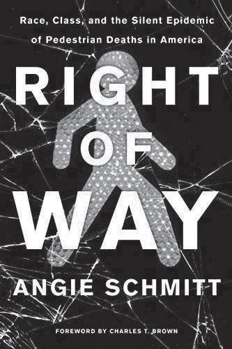 by Angie Schmitt
Review by Emma Vinella-Brusher
by Angie Schmitt
Review by Emma Vinella-Brusher
EMMA is a second-year student in the Master of City and Regional Planning and Master of Public Health dualdegree program, interested in reducing transportation barriers to food, healthcare, greenspace, and other vital goods and services. Born and raised in Oakland, CA, she received her BA in environmental studies from Carleton College before spending four years at the U.S. Department of Transportation in Cambridge, MA. In her free time, Emma enjoys running, bike rides, live music, and laughing at her own jokes.
78 CAROLINA PLANNING JOURNAL
Island Press, 2020. 227 pages
The World Health Organization reports that road traffic injuries are the leading cause of death for children and young adults ages 5–29. This “silent epidemic” is killing more than 6,000 pedestrians on US roads each year, yet planners, engineers, and policymakers continue creating built environments that are what Smart Growth America calls “dangerous by design.”
As a renowned expert in safe, sustainable transportation, it is no surprise that journalist Angie Schmitt’s book received the blessing of Charles T. Brown, founder of transportation equity research and policy firm Equitable Cities. In his foreword, Brown praises Schmitt’s “intentionality, empathy, and courage to act expeditiously” in the fight to eradicate pedestrian injuries and fatalities in low-income and minority communities across the United States.
Right of Way begins by laying out the simple reality of road safety in the US—cars are getting larger and more dangerous while pedestrians are dying at numbers not seen in decades, particularly in vulnerable, underresourced communities, yet no substantial national action has been taken to address this. The fear pedestrians face every time they step out the door and into traffic is a relatively new phenomenon. Pedestrians once ruled the road before the era of cars, with the 1920s media going so far as to call the reference to traffic fatalities as unavoidable accidents the “perjury of a murderer” (p. 69). American culture has done a full 180 since then, now blaming pedestrians for their own injuries or even death after a run-in with a car.
By regulating pedestrian behavior—for example, through 28 different identified infractions on the books in Florida—the US has framed traffic deaths as the fault
of the victim rather than the driver of the 4,000+-pound vehicle. If only the person who was hit wasn’t peeking at their cell phone, if they weren’t crossing at an intersection without a crosswalk, if they were wearing reflective clothing even in daytime…
In blaming traffic victims for their own deaths, we have helped to establish a “new normal” where pedestrian fatalities are consistently 50% higher than just a decade before (p. 12).
Schmitt quickly debunks the common argument of distracted walking contributing to increased traffic deaths over the last decade. About 75% of pedestrian fatalities occur at night when holding a glowing phone would likely improve their visibility, about 73% occur outside of intersections when a crossing would feel “relaxing” enough to be tempted to check one’s phone, and older adults are overrepresented in traffic deaths despite being far less likely to own and regularly use a smartphone. (p. 12).
Through the use of vivid storytelling—such as the hit-and-run death of 77-year-old Ignacio Duarte-Rodriguez as he crossed six lanes of fast-moving traffic to grab cigarettes at a local market, the deaths of Samara Banks and her three children under four as they attempted to cross all twelves lanes of the street in front of their home, and the killing of 49-year-old unhoused Elaine Herzberg by a computerpiloted Uber vehicle whose automatic braking feature had been intentionally disabled by the company—Right of Way shows what happens when we prioritize vehicle movement over the lives of our most vulnerable.
Schmitt identifies these and other pedestrian deaths as a systemic design problem inherent
79Planning for Healthy Cities
to our built environment. A 2014 study by the U.S. Federal Administration was able to predict, with 90-percent accuracy, where a pedestrian would be likely to cross midblock based on environmental factors such as presence of a right turn lane, distance between crosswalks, and bus stop location (p. 71). This indicates that jaywalking, though criminalized in today’s society, is often out of necessity due to a lack of adequate pedestrian infrastructure. This is oftentimes particularly stark in areas of concentrated poverty—where the poor are punished by having to live in places lacking pedestrian-safe infrastructure, often without having access to an option besides walking.
To address this, Right of Way calls for an overhaul of the policies and processes that govern our roadways. Despite pedestrian and cyclists now accounting for about one in five traffic deaths in the US, these modes receive only 1.5% of federal transportation funding—about $2.65 per American per year. Furthermore, the Manual on Uniform Traffic Control Devices (MUTCD), which regulates US road design, prioritizes efficient car movement over the safety of other road users—and even actively “discourages traffic engineers from
installing crosswalks” (p. 100). For example, the MUTCD states that a traffic light is only warranted at an intersection if five pedestrians have been injured or killed by a car there in a single year. Furthermore, where signals do exist, crossing timing is based on how long it takes for a relatively fit middle-aged adult man to cross, leaving most Americans with insufficient time to safely get across an intersection and out of the way of cars.
Though published in August of 2020, Schmitt completed the writing of Right of Way more than a year before the COVID-19 pandemic took hold of the world and further exacerbated existing health inequities. Despite far fewer drivers on the road and a more than 13% drop in total miles driven due to lockdowns and working from home, the US saw the most roadway fatalities in 2020 than it had the decade prior—nearly 40,000 deaths. Schmitt’s book is a rallying cry for residents and politicians across the nation to take bold actions to enhance road safety before even more vulnerable road users are injured, or worse, killed. It is an important read for all Americans, particularly those that rarely have to experience the fear that comes with being a pedestrian on roads in the United States.
80 CAROLINA PLANNING JOURNAL
REVIEW
UNEVEN INNOVATION: THE WORK OF SMART CITIES
 by Jennifer Clark Review by Joungwon Kwon
JOUNGWON is a third-year PhD student in the Department of City and Regional Planning. With a statistics and English literature background, she received her MA in computational media at Duke University. Her academic interests include visualizations in plans, urban technology, and sustainable cities. She has been part of Carolina Planning Journal since 2019.
81Planning for Healthy Cities
Columbia University Press, 2020. 372 pages.
In the past decade, smart cities have been a buzzword with an unclear definition. Jennifer Clark’s Uneven Innovation: The Work of Smart Cities disentangles the concepts of smart cities projects by reviewing technology problems, urban entrepreneurialism, and the new element of urban innovation networks. Clark offers a historical review of cities and the identifies of how smart cities are different, which serves as a framework to analyze smart cities. Clark also critiques the present patterns of smart cities and proposes specific recommendations and policy solutions for smart cities projects. Clark provides a foundation for people to think about smart cities project as an urban policy project instead of a technology project.
While smart cities are known as using technologies to create livable cities, Clark defines the fuzzy concept of the smart cities projects as “technology diffusion challenge operating in a dynamic and contested space between the public and the private sector” (xii). With the definition, the author introduces an alternative framework for understanding smart cities projects instead of the common misconception that smart cities projects are only about technology. In order to comprehend the framework, Clark illustrates five premises. The first premise is that cities have been and continue to be under uneven innovation. It is essential to acknowledge that, currently, cities have different geographical advantages, and technology expedites the uneven development of cities. The smart cities projects need to intentionally design cities that can mitigate inequalities instead of defaulting to the idea that smart cities will magically fix cities’ problems.
The second premise is that tech firms exploit and maintain uneven innovation. While tech firms offer services and infrastructures to cities, cities provide the abundant locational data. Tech firms carefully select the cities that will offer advantage for their businesses such as cities with less regulations. Although cities need the services and infrastructures,
I believe this premise shows that cities have the upper hand to form the future smart cities because the cities control and collect the data. The third premise is that the smart cities projects are usually created quickly with fast policies. The expedited policy process of the projects do not leave much room for evaluation or validation. The fourth premise is that “The smart cities project exacerbates and amplifies precarious work, embedding labor flexibility in the production and operations of the built environment” (p. 14). With the technology’s infrastructure and connectivity, the projects blurs the line between employer and employee, making employee rights ambiguous, which perpetuates problems. The last premise is that the revenue model for collecting and selling the data is unclear. One of the main advantages of smart cities is how data is collected, integrated, and used. However, the neighborhood scale’s long term cost benefit is difficult to assess and the model needs a clear structure. These five premises help readers understand Clark’s arguments in the book and connect with the historical facts of cities.
The smart cities projects have many problems—all of which Clark ultimately ties back to preexisting urban problems, which is uneven development. The diffusion of existing problems of uneven development and
82 CAROLINA PLANNING JOURNAL
technology are not helping but exacerbating the fact. One of the main takeaways from the book is to
“stop reproducing uneven development patterns through technology solutions” (p. 216).
Clark argues that cities incorporating smart cities projects need to stop the continuous loop of uneven innovation. Cities cannot rely on the smart cities projects to bring economic benefits without the problems of producing and increasing inequalities because the problems of privatization in cities and economic growth already exist. Cities can solve the problems with the right urban policies to solve the uneven development and create equitable cities.
Uneven Innovation’s organization allows the readers to understand Clark’s arguments effortlessly. The book provides the history of urban policies, the smart cities projects’ similarities and distinctions from technology sectors, interjurisdictional competition, history of urban entrepreneurialism, and recommendations for the smart cities book offers academics a closure of questions on the methodology. Clark’s carefully thought structure allows readers to understand the history and problems of smart cities and view smart cities as an ongoing urban problem. Moreover, the epilogue also serves a great purpose of providing the methods to her findings and arguments. Although it is not an academic article, having a part of the book dedicated to methods at the end of the book offers academics a closure of questions on the methodology.
In the book’s conclusion, Clark provides three recommendations—invest in embedding innovation capacity within city government, create urban policies to use data advantageously while citizen rights to data are considered, and redesign and expand the participatory planning practices with new technologies. The recommendations are brief but valuable and comprehensible with the previous chapters. She also acknowledges that she did not offer concrete recommendations for all smart cities’ problems. Even if the recommendations may be incomplete, readers will benefit from Clark’s other solutions to the smart cities projects.
Future editions should consider including case studies, such as specific solutions to a particular city. Another point that will be useful for future editions will be the example of the Sidewalk Toronto project, a collaborative smart cities project between Toronto and Google. In May 2020, Sidewalk Labs canceled Toronto’s smart city project. The book was published before the cancellation. Linking the argument of smart cities’ slow implementation due to the lack of money with the project’s cancellation will be interesting.
Clark’s thorough analysis and carefully crafted organization of the book enable readers to understand the problems of smart cities as urban policies instead of a new problem that cities have never faced in the past. Instead of critiquing existing smart cities projects, Clark critiques policies that create uneven development. Understanding the uneven development as a preexisting problem of cities helps identify the smart cities’
83Planning for Healthy Cities
problems to cities. Often the problems of smart cities seem unique and challenging to solve. However, Clark encourages readers to understand smart cities in a broader framework, which would allow them to address smart cities problems.
In 2021, Uneven Innovation: The Work of Smart Cities was awarded the Urban Affairs Association Best Book Award. Clark’s thorough analysis of the smart cities projects and brief recommendation will be
a great addition not only to urban analytic courses but also to urban history courses in planning departments. This book will be a fascinating and informative read to anyone who is interested in understanding the problems of past and future cities. Policy makers and tech-sector engineers involved in city-scale projects will also benefit from reading the book to the very end, where recommendations are presented.
84 CAROLINA PLANNING JOURNAL
REVIEW
THE CITY CREATIVE: THE RISE OF URBAN PLACEMAKING IN CONTEMPORARY AMERICA
 by Michael H. Carriere / David Schalliol
Review by James Hamilton
by Michael H. Carriere / David Schalliol
Review by James Hamilton
JAMES is a first-year master’s student with the Department of City and Regional Planning whose interests center on urban form as it relates to community marginalization, environmental justice, societal cohesion, and suburban retrofit. He studied public policy and economics at Duke University and has since worked in New Orleans and New York before circling back to the triangle. Never happier than when he is hiking up a mountain or traveling on a train, James fails to commit enough time to his average writing collections, ambitious reading list, and lifelong rugby enthusiasm.
The University of Chicago Press, 2021, 336 pages
85Planning for Healthy Cities
Placemaking has long held a coveted position in planning literature as a central tenant of good urban form. Jane Jacobs, Kevin Lynch, and their considerable academic company formalized thought on the interplay between social capital and design, thus laying a framework for those hoping to arrange public space to create community. But truly successful places tend not to be made consciously by planners or developers, most of whom are preoccupied with the economic benefits of increased sociability; instead, the kinds of spaces Jacobs and co. idolize are most effectively cultivated by community members who do not necessarily see their work as placemaking—so is the process replicable? If so, how?
By detailing more than two hundred initiatives, The City Creative is an attempt to answer—or, rather, reframe – these questions. The book pairs the historical fluency of Michael H. Carriere (Associate Professor of Humanities, Social Science, and Communication at Milwaukee School of Engineering) with the storytelling and sociological expertise of David Schalliol (associate professor of sociology at St. Olaf College) to trace placemaking as an understated revolutionary tool that can be harnessed to reach a more equitable future. In their words, they “strive to use the processes of embedded observation and communityrooted engagement to help illuminate the merits, demerits, and possibilities of a more inclusive, more equitable approach to placedbased action.”
Their exploration is divided into two distinct halves that together convey the evolution of creative placemaking. The first unpacks its history, paying primary attention to mainstream influences. The first chapter “The (Near) Death and Life of Postwar American Cities” documents the movement’s roots, which concluded that anonymous, unsafe spaces “needed to be reclaimed… by strengthening…urban social bonds” and that “the promise of sociability” could be “the cornerstone for urban economic redevelopment” (p. 52). However, in order to understand the role that the history of placemaking played in the creation of American cities, the authors chose to further scrutinize “The Roaring ‘90s” (chapter 2), shifting from traditional schools of thought to their more contemporary offspring, such as communitarianism and new urbanism. The authors argue that small-scale activism responding to globalization and the sanctity of private property, although only narrowly influential at the time, “crafted a template for how creative placemaking would grow” by “foreshadow[ing] the neighborhood-centric model…that would inform the practice” (p. 79). The study goes on to paint the current state of what modern creative placemaking is understood to be. It discusses how the disintegration of social ties is tied to space, how the economy is increasingly driven by individuality and self-expression, and how the resulting “creative class” have the resources to transform that space.
The City Creative’s second half documents efforts to direct sociability towards the
86 CAROLINA PLANNING JOURNAL
revitalization of communities as healthy and equitable ecosystems, beyond simply activating spaces. The pages are the product of the authors’ documentary-style research, spanning ten years of interviews, community meetings, protests, and other such means of first-hand connection to actors critical of mainstream placemakers. These voices believe that the practice is a means of
“transforming the social as well as economic, political, and cultural forces that have given us the city of the early twenty-first century” (p.21).
Chapters 4–6 are meant as a demonstration of how democratizing modern creative placemaking can promote production as a concept beyond marketplaces. This production has traditionally been viewed as vague—community connections and identity, for example—but the authors try to show how it can also be concrete—“temporarily transforming a field house into a brick-andmortar library,” for example (p. 24). Through this lens, The City Creative proposes that the placemaking movement must “embrace a vision that is holistic, redistributive, and cognizant of the connection between tangible and intangible outcomes” in order to minimize displacement and unequal economic development.
If The City Creative has a major pitfall, it is that its coffee-table-book-esque format primes the audience for a visual-forward read but is instead met with dense text and interspersed, minimally referenced photographs. It wants to be both an academic text and an art exhibition so fails to be either. It is also not the how-to guide for which pragmatic readers would hope: they would not leave with the same decisive recommendations that they might from Jacobs or Lynch.
That said, Carriere and Schalliol make it very clear that their purpose is not to prescribe action to budding creative placemakers so much as it is to document the process. Their deliberate shift in outcome prioritization, from social capital to social justice, feels a fresh and worthy advancement of placemaking literature. Anyone studying the field in the contexts of academia or revitalization would benefit from the grassroots insights that, if the reader is open-minded, have the substance to shape modern perceptions of how public space should be used. Perhaps others will codify and make practical the findings of this exploration, but for now The City Creative stands alone as a meticulous, thoughtful depiction of how community collaborations, both unpresuming and activist, mold equitable spaces in ways with which governments and developers cannot compete.
87Planning for Healthy Cities
REVIEW
LAST SUBWAY: THE LONG WAIT FOR THE NEXT TRAIN IN NEW YORK CITY
 by Philip Mark Plotch
Review by Sophia Nelson
by Philip Mark Plotch
Review by Sophia Nelson
SOPHIA is a first-year Master’s student in city and regional planning, specializing in Transportation Planning. She is particularly interested in urban public transit systems and equitable community engagement. Sophia received her undergraduate degree from the University of Washington, where she studied urban planning, landscape architecture, and Geographic Information Systems
88 CAROLINA PLANNING JOURNAL
Cornell University Press, 2020, 360 pages
Healthy Cities
Over the last century, New York City has struggled to build a new subway line along Second Avenue. Since it was first proposed in 1903, some variation of the Second Avenue subway project has been in a continuous cycle of delay, cancellation, and reintroduction until the first phase finally opened in 2017.
In Last Subway: The Long Wait for the Next Train in New York City, author Philip Mark Plotch details the long and difficult journey to build “the most expensive subway in the world.” He presents the complex political, financial, and physical barriers to building a Second Avenue Subway, and why it took over a hundred years to finally open the first phase of the project. However, Last Subway is not simply a retelling of the history of New York City’s transportation system. It also serves as a warning to cities for what happens when politics become entangled with infrastructure megaprojects.
Plotch has explored the challenges of American transportation systems and brings his expertise in New York City politics and policy analysis to Last Subway. As a U.S. Fulbright Scholar, political science professor, journalist, and urban planner, he has played a key role in New York’s infrastructure planning and development. Particularly through his experience as the Manager of Planning and Policy at the MTA between 1992 and 2005, Plotch has first-hand knowledge of transportation projects such as the 7 Subway Extension and the infamous Second Avenue subway. His understanding of the internal dynamics and history of transportation planning in New York City deeply enriches the storytelling.
Plotch begins the story by setting the stage for New York City’s transportation system.
He describes how the subway system transformed New York “From a Compact City into a Metropolis” in Chapter 1. In the 1920s, the subway system in New York was once considered one of the most modern and efficient public transit systems in the world. As decades marched on, the subway deteriorated, and the Second Avenue project seemed to be nothing more than an empty promise. Politics continued to complicate progress as the city was more concerned with keeping fares low than making long-term investments in infrastructure improvements. Although construction had finally begun on the project in the 1970s, the MTA eventually abandoned it again to focus on aging infrastructure and safety improvements in the 1980s. While Plotch’s historical storytelling is fascinating, the final chapters were the most captivating and effective for his argument. Ending with “Andrew Cuomo’s Finish Line,” we learn how the Second Avenue project was finally prioritized in New York City. What makes Last Subway such an impressive book is the storytelling through different key figures in New York City over the last century. Plotch does an excellent job of personalizing transportation history through the description of significant planners and politicians. For example, Robert Moses and his steadfast determination to build an expansion highway network is a familiar story to many, but how did he acquire those funds? Why were some transportation projects prioritized over others? On the other hand, there were important figures who championed for the public transit system. For example, Mayor Fiorello La Guardia led an effort to unify the transit system. Later, Governor Nelson Rockefeller created the MTA. Planning leaders such as Richard Ravitch and Robert Kiley
89Planning for
developed capital programs and pushed for investment. And finally, Governor Andrew Cuomo—who was primarily concerned with pet projects that would portray him as an effective leader—received credit for making it happen. The power of politicians to promote support or shut down a particular project is thoroughly explored in Last Subway, which Plotch sums up nicely:
“One of the cynical lessons learned from the past century is that New York’s politicians benefit when they tell people that they are studying, planning, designing, and preparing for the Second Avenue subway. They do not have to actually start building it to reap rewards” (p. 268).
The historic storytelling in Last Subway is rich and colorful yet is sometimes difficult to follow. The complex history of the Second Avenue line necessitates detailed writing,
but it is easy to get lost in the details. Telling a centuries’ worth of public transportation history in just one book is no easy feat, but sometimes I questioned the relevance of some minor details. Nonetheless, the different twists and turns in the history of the Second Avenue subway kept me engaged throughout the whole book.
Last Subway is an excellent read for anyone interested in the intersection of New York City transit, history, real estate, and politics. Transportation planners, engineers, or enthusiastic urbanists would benefit from learning about the Second Avenue subway. All in all, Last Subway is a thoughtful and engaging inside look at how transportation megaprojects can succeed or fail in American cities.
90 CAROLINA PLANNING JOURNAL
REVIEW
SUNBELT BLUES: THE FAILURE OF AMERICAN HOUSING
 by Andrew Ross
Review by Jordan April
by Andrew Ross
Review by Jordan April
JORDAN is a second-year student in the Master of City and Regional Planning and Master of Public Health dual-degree program. They are interested in housing affordability, healthy housing, health equity, and lead poisoning prevention. Jordan received their undergraduate degree in government and international politics from George Mason University. Originally from Upstate New York, they have had prior internships with Legal Services of Central New York, the National Center for Healthy Housing, and the National Low Income Housing Coalition.
Holt, Henry & Company, Inc., 2021, 288 pages
91Planning for Healthy Cities
Osceola County, Florida, is ruled by contrasts. On one end of the fifteen-mile stretch of Route 192, there lay thousands of luxury vacation home rentals, often owned by multinational investors and realty firms catering to out-of-state and international tourists. On the other are languishing motels that serve as a last resort of housing for the underpaid workers that the tourism industry requires, and for others priced out of the increasingly expensive housing market.
Sunbelt Blues casts its lens primarily on the latter, on those who live in the bedbug infested motels that line the 192 corridor as it approaches Kissimmee. Long-time author, professor, and activist Andrew Ross centers the lived experiences of the victims of the affordable housing crisis in Central Florida, grounded in interviews and investigative reporting. The causes of Osceola County’s acute housing affordability problem are nebulous, multi-faceted, and extend far beyond its borders. However, Ross highlights one significant cause: the commodification of housing. Statistics are paired with ordeals of those interviewed to support a significant call to action, of the need to “cast off the ruinous habit of seeing housing almost exclusively as real estate… and treat it instead as a basic need and human right” (p. 14).
The first three chapters focus exclusively on the motel residents, including the perspectives of government officials, motel owners, and the residents themselves. While a variety of causes brought these legally unprotected tenants to the motels, trauma, addiction, and poverty are some of the main perpetrators. Most are in economically and legally tenuous positions, in which motels are not formally recognized as long-term housing
and long-term residents are not recognized as tenants. County government also plays a role in this dynamic, Ross explains that the sheriff’s department often use motels as “a convenient way of warehousing the poor” (p. 51). The tourism industry does not create an incentive to resolve the affordable housing problem, but rather works to hide the problem.
Each following chapter addresses a different part of the county and its specific housing issues. Chapter four looks at the encampments of unhoused people in the woods along 192, many of whom were driven there due to drug addiction, mental illness, a felony conviction, terminal illness, or poverty. The fifth chapter delves into a source of housing instability: Disney World. The motels along 192, meant to serve Disney’s tourists, instead house many Disney employees. Here, Ross highlights the dark underbelly of Disney’s manufactured happiness, in which most of the “cast members” tasked with making it the “happiest place on Earth” are not paid enough to survive. Chapter six focused on Celebration, Florida, a New Urbanist town constructed by Disney, which once promised happiness and utopian ideals of community. Following the sale of the town center to the private equity firm Lexin Capital, these ideals were abandoned in favor of profits for investors, high housing costs, and deferred maintenance. Similar goals of profit are focused on in chapter seven, where the thousands of vacation home rentals stand vacant during the off-season in a county with desperate needs for affordable housing. Lastly, chapter eight looks toward the future of Central Florida in the face of climate change.
The region is a likey location for future climate refugees from the state’s coastal cities, which would
92 CAROLINA PLANNING JOURNAL
make affordable housing even rarer in what may become an “ecoapartheid” (p. 192).
A significant strength of Sunbelt Blues is the respectful treatment and humanizing reporting of those on the margins of society in Osceola County. Where it may be easy to cast judgment on those living in the encampments in the woods, or the drug dealers operating up and down the 192 strip, Ross avoids falling into this trap. The blend of qualitative and quantitative information, derived from sources such as interviews, government documents, and housing reports, casts a harrowing and compelling picture of the realities of the housing crisis. Abstract statistics, such as housing cost burdens, are grounded in the lived experiences of interviewees, to provide a more comprehensive view of what the affordable housing crisis means for us and our communities. Ross’s research was made even more prudent and relevant through its consideration of how the COVID-19 pandemic deepens inequality, makes even more people in Central Florida vulnerable to eviction and instability, and how private equity firms have taken further advantage of this new housing crisis.
Surprisingly, covering nearly every facet of housing in Osceola County in depth is an impossible task for one book to do. The sheer breadth of housing conditions discussed in the chapters ultimately resulted in attention being taken away from Ross’s initial population of focus: those residing in the motels. Including more elements of everyday life for week-to-week motel residents would have further supported Ross’s thesis.
Another significant argument that could have been further explored is housing as a human right, and how housing also impacts one’s health. Both of these arguments could have been bolstered by a greater focus on the impacts motel life have on resident’s physical and mental well-being, as well as particular hazards imposed by the environment, whether it be bed bugs, mold, or water quality. The poor condition of the motels was heavily emphasized, but not necessarily the health consequences experienced by its residents as a result. This link is an important one to make, and to continue making, as we advance the fight for housing justice.
Sunbelt Blues was an ambitious undertaking with an expansive research population and geography. Ross concludes by re-emphasizing the need to remove the question of profit from housing, to finally “achieve the goal of homes for all”, and “de-financialize housing and pivot away from the failed market model” (p. 212). The language and depth of its research allows for this book to serve as a strong introduction to the housing crisis for those unfamiliar, a qualitative resource for practitioners and policymakers, and as a call to action for everyone. This book is a powerful step in helping reframe the rhetoric around housing in the United States, and achieve a paradigm shift where housing is a human right.
93Planning for Healthy Cities
REVIEW
THE AFFORDABLE CITY: STRATEGIES FOR PUTTING HOUSING WITHIN REACH (AND KEEPING IT THERE)
 by Shane Phillips
Review by Isabella Niemeyer
by Shane Phillips
Review by Isabella Niemeyer
ISABELLA is a first-year master’s candidate in the Department of City and Regional Planning with a specialization in housing and community development. She is particularly interested in the intersection between participatory planning, community engagement, and equitable housing reconstruction. She received her undergraduate degree in geography and French from The Ohio State University, and enjoys talking about the Midwest and her dog Percy.Review
Island Press, 2020, 280 pages.
94 CAROLINA PLANNING JOURNAL
It is difficult to think that solutions to the housing crisis can be surmised in the clever alliterative, “Supply, Stability, and Subsidy”, but Shane Phillips manages to do just that. Bridging traditionally opposing views, Phillips argues that those fighting for housing affordability can come together under future planning policy goals that tackle each of the “Three Ss”. The book is organized into three parts: Principles and General Recommendations, Policies, and Bringing it All Together
Shane Phillips is an urban planner and currently manages the UCLA Lewis Center Housing Initiative. After working on housing affordability initiatives with a variety of stakeholders, he writes a book to unite “prosupply” and “pro-tenant” parties. The former are those who believe the solution to housing affordability is an increase in housing units, and the latter are those who believe the solution is preservation and protection to fight displacement. Traditionally juxtaposed in housing affordability debates, Phillips uses this book as an opportunity to discuss policy solutions in tandem with one another.
In Part I: Principles and General Recommendations, Phillips lays the foundation for the rest of the book by providing general guidelines for housing policy. Where many books leave this to reader interpretation, Phillips is very clear in the ways in which he outlines principles that can be shared with all those involved in the housing affordability movement. These principles are all broad in scope with examples ranging from focusing on institutional reform to adapting solutions to local problems. Phillips designs Part I to be aspirational, perhaps to the point of delusion. He argues that solving the housing crisis is about “making the moral and economic case
for action,” (p. 29) as if community members have not been making moral and economic cases for generations. While it may be difficult to visualize the reality of some of his aspirations, they are central to the mission of the book—to realign positions from both sides. By setting a clear framework from the beginning, Phillips allows the reader to turn their attention to important policy initiatives rather than arguing for one side or another.
Phillips offers concrete policy examples of each of “the Three Ss” in Part II: Policies
Each policy is grounded contextually in a real-world example, and Phillips does an excellent job at discussing the many sides to the policy. Beginning with “supply,” policy examples include ones that many of us hear in the planning field like eliminating parking minimums and density limits. Phillips brings in the more technical side of planning by discussing administrative procedures to speed up the supply market, i.e., “by-right” approvals versus “special use” permits. In terms of Stability, Phillips explicitly discusses tenant rights and how developers and the government can work to create affordable environments without compromising safety. Fundamentally, this section is about transparency and accountability; if the housing system still allows for tenant buyouts, rent hikes, and evictions—all these should be done transparently and with clear guidelines for tenant protection. Finally, Subsidy policies integrate local and federal government involvement into the housing sphere. These offer tax policy initiatives like establishing a real estate transfer tax or taxing flipped homes at a higher rate. Building off other sections, Phillips calls to prioritize housing stability over housing as a wealth creation tool by eliminating homeowner subsidies and increasing the
95Planning for Healthy Cities
potential for rental assistance. While these are not at all a comprehensive list of housing policies that may be a solution to each issue, it is a selection of those which may unify. Phillips offers sound advice and policy guidelines for large metropolitan areas but prefaces any guidance by saying that there is not a one size fits all approach to planning policy. This does mean, however, that he does not account much for areas outside of large metros including rural or suburban communities. While policy measures do have to account for geography, it is important for broad policy guidelines to start to incorporate these geographies into the discussion. By excluding non-metropolitan geographies, Phillips may not be able to discuss the ways in which issues like urban sprawl affect housing affordability.
These policies are further grounded using a timeline in Part III: Bringing It All Together Phillips categorizes policies in order of immediate, medium-term, and long-term priorities. Unlike many housing scholars who may speak to one group or another, he clearly lists out ways that each person can get involved in the fight for housing affordability. While the designations of priority are crucial, Phillips may be too simplistic in the viability of
this timeline. Where Phillips bridges the gap between pro-tenant and pro-supply discourse in this part, he does not explicitly discuss how to implement these policies. It is clear that he understands the nuance of these issues, but he does not go into detail about how this nuance may affect the way that these plans are implemented.
It is easy to remove human life from the discussion around housing policy—to reduce it as a conversation for policymakers and developers. Housing policy needs to be accessible to communities it desires to protect so that they have a stake in the conversation. The Affordable City is an incredibly thorough review of modern affordable housing initiatives written in a way that can be understood by many. Phillips writes effectively, cohesively, and offers an insightful curation of policies and guidelines. Unlike other works, it is readable to those without broad policy knowledge, and it does not offer platitudes or easy excuses which may bring those with differing opinions to the discussion. Housing is a robust and complex topic that must be discussed with curiosity, compassion, and cohesion—Phillips offers all this and more in this book.
96 CAROLINA PLANNING JOURNAL
REVIEW
FEMINIST CITY: CLAIMING SPACE IN A MAN-MADE WORLD
 by Leslie Kern
Review by Sarah Kear
by Leslie Kern
Review by Sarah Kear
SARAH is a dual master’s student in the Department of City and Regional Planning at the University of North Carolina at Chapel Hill and in the Nicholas School of the Environment at Duke University. She received her undergraduate degree from the University of Wisconsin-Madison in political science, gender and women’s studies, and Chicanx and Latinx studies. In her free time, Sarah enjoys running and trying out different recipes.
Verso Books, 2021, 224 pages.
97Planning for Healthy Cities
Like being a woman, living in a city as a woman is a double-edged sword. Feminist geographer Leslie Kern delves into the systems of oppression women face in urban areas while acknowledging particular freedoms in Feminist City. Cities may provide better opportunities for women to create community than the suburbs, yet political, cultural, and structural proponents of urban built environments continue to limit and suppress women’s experiences and livelihood. Kern provides a comprehensive look into the multi-dimensional oppression women experience throughout five chapters. Kern does not provide an explicit list of women’s needs for a feminist city but highlights the oppression that limits a feminist city. Similar to previous feminist literature, Kern focuses her main points on her personal experiences while drawing on pop culture and relevant scholarship to bolster her claims.
Kern argues that historically, women are repeatedly seen as a problem in the modern city. From prostitution to the racist stereotype of the “welfare queen,” the modern city’s institutions, which are primarily run by white, cisgender men, stridently impose normative patriarchal family values as a means of regulating the autonomy of women in cities. Victorian era fears of purity and cleanliness are still present and continue to police women through physical, social, economic, and symbolic barriers. Kern further argues that cities are designed to support and promote western, traditional gender roles, where men’s experiences are the “norm” and the barriers that directly affect women are rarely encountered.
Throughout Feminist City, Kern also looks towards the prior research of women in cities when centering her claims of cities possessing
the capabilities of suppression and freedom. Kern’s PhD supervisor Gerda Wekerle claims that “a women’s place is in the city.” While Betty Friedan spoke about the value of increased opportunity and community in cities compared to suburbs. In suburbs, women are more harshly subjected to patriarchal family values and are deliberately isolated to keep them attached to the home. Kern uses these claims as a foundation as to why women need cities but also why the systems of oppression need to be abolished.
In each chapter, Kern centers the main points on her own experiences. Kern acknowledges her privilege. She is an educated, cisgender, white woman who does not have similar experiences as other marginalized individuals that also live and navigate in modern cities. Along with her personal experiences, Kern attempts to center the experiences of BIPOC and transgender women yet, at times, these sections read like added commentary rather than a full centering of their experiences. Since the book is largely based on her own experiences, the other voices do not receive equitable space and because of her privileged perspective, it seems that Kern expects readers to be similarly privileged. Through this lens, Kern does take the opportunity to highlight her evolving perspective considering intersectionality while raising the voices of those historically marginalized in feminist and academic spaces.
In one moment, Kern describes her research regarding gender and condominium developments, acknowledging the efforts of organizers and activists. Condominium developers in Toronto market condos as the safest option for women because of security features. Yet, Kern argues that when condos are marketed as “safe” for women, developers
98 CAROLINA PLANNING JOURNAL
are able to continue gentrification. Not only are women positioned as a catalyst for gentrification, but it continuously perpetuates security privatization, where individuals are responsible for their safety. Kern also claims that making safety a private commodity in cities restricts access to those with the economic means to buy safety. Kern supports neither security privatization nor the need to expand the criminal punishment system in the name of gendered violence. As part of her argument against incarceration, Kern credits the work of Mariame Kaba and Lola Olufemi, activists who advocate for radically reshaping safety as a means of care. Here, Kern strives to use her platform to highlight activists’ efforts to create a more equitable modern city. Acknowledging these roles as imperative parts of a modern city lends credibility that
has historically been absent in both feminist and academic spaces.
Feminist City provides personal accounts of how modern cities continue to perpetuate women into traditional western gender roles through physical, social, and political barriers. Feminist City may provide a starting point for readers to identify how they live within the barriers or contribute to the barriers. While Kern offers how cities might change, she also posits that women unconsciously embody habits in response to the barriers of modern cities, suggesting that active introspection will facilitate better alternatives. Kern’s intertwining of personal experience with feminist urban discourse acknowledges the individual and collective experiences that are needed to build a more equitable urban city.
YEAR IN REVIEW
Each year we like to shine a spotlight on the many accomplishments which the Students, Faculty, and Staff of the department have had over the past year. This past year has been another period of changes, returning fully remote classrooms and research projects to once again walking UNC-Chapel Hill’s campus. This transition has not been easy. However, in light of these hurdles, there have been wonderful moments of friendship, reunions, research successes, and further pursuit of academic excellence. Students from our department have taken adversity in stride, winning awards, creating new organizations, and traveling to conferences. Our faculty have also grown, welcoming new lectures and postdocs. We also celebrated the department’s 75th anniversary in a celebration attended by alumni near and far. Looking forward to the 2022–2023 academic year our department is expecting to welcome 49 Master’s students and three PhD students. This spring, a tentative 28 Masters and two PhD students will graduate and step forward into their life path.
99Planning for Healthy Cities
STUDENTS
Lauren Prunkl was awarded the Dwight D. Eisenhower Transportation Fellowship to support research for her Master’s project. William Anderson and Hannah Etter were the first students enrolled in the newly created dual Bachelor’s/MCRP degree at UNC. Emma Vinella-Brusher was the recipient of the 2021 U.S. Department of Transportation University Transportation Centers Outstanding Student of the Year award. Eve Lettau worked alongside NCGrowth providing assistance to distressed communities across the state. The 2021 Best Master’s Paper winner was Emma Stockton. Her MP is titled “Active Transportation Policy Decisions in Response to COVID-19: Case Studies from Four North American Cities” and her advisor was Dr. Tab Combs. The 2021 People’s Choice winner is Emily Gvino. Her MP is titled: “Addressing the Health Impacts of Extreme Heat: Interdisciplinary and Equitable Framework for Urban Heat Management in the Southeastern United States” and her advisor was Dr. Danielle Spurlock.
With the possibility of travel returning, multiple students began to travel to conferences once again. Lauren Jensen, Amanda Ullman, and Pierce Holloway traveled to Glasgow, Scotland to attend the 26th UN Conference of Parties as observers. Melissa Ashbaugh, Julia Maron, Katie Burket, Marielle Saunders, Eve Lettau, Amy Patronella, and James Hamilton attended the national APA conference in San Diego, California. UNC Transportation Planning students Emma Vinella-Brusher, Lauren Prunkl, Marc Moore, Jordan Powell, Sarah Kear, and Zoe Huebner trekked to Blacksburg, Virginia for the 2022 Southern District Institute of Transportation Engineers (SDITE) Student Leadership Summit.
Student organizations continued to grow over the past year. Map Club was created between the efforts of Duncan Jones and Christy Fierros, seeking to expand GIS skills and spatial data visualization. Wren Hess, in conjunction with Associate Professor Andrew Whittemore, hosted a panel of LGBTQ planners discussing placemaking, safe spaces, and community building in the planning field. Michael English has conducted interviews with professionals in multiple fields laying the groundwork for a DCRP podcast.
STAFF AND FACULTY
Department staff also had an impressive year. Danielle Spurlock has been selected by the Robert Wood Johnson Foundation (RWJF) for its prestigious Interdisciplinary Research Leaders (IRL) program. She is also honored with winning the 2022 Engaged Scholarship Award. Bill Rohe, former Cary C. Boshamer Distinguished Professor of City and Regional Planning and former Director of the Center for Urban and Regional Studies, received the Urban Affairs Association’s 2021 Contribution to the Field of Urban Affairs award. Allie Thomas investigated how e-bikes address family travel needs in the San Francisco Bay area. Tab Combs built the leading database cataloging how cities have responded to COVID-19 globally. Nikhil Kaza, Nichola Lowe, and Noreen McDonald developed a database to track 30 economic, social, and transportation indicators for all 100 counties in North Carolina. Evan Iacobucci, Jihoon Jung, and Sophie Kelmenson joined the department as post-Docs. Richard Hails was apportioned as lecturer, providing years of professional experience as a planner. 2021
100 CAROLINA PLANNING JOURNAL
MASTER’S PROJECTS
BEST MASTER’S PROJECT
EMMA STOCKTON
ACTIVE TRANSPORTATION POLICY DECISIONS IN RESPONSE TO COVID-19: CASE STUDIES FROM FOUR NORTH AMERICAN CITIES
This Master’s Project explores the planning processes, implementation, and public reactions to new active transportation infrastructure built in response to the COVID-19 pandemic in four North American cities (Washington, DC; Chapel Hill, NC; Oakland, CA; and Halifax, Nova Scotia). The implementation of active transportation infrastructure moved abnormally quickly to respond to an increased demand for walking and biking in local areas due to COVID-19 lockdowns, restrictions on travel, and closures of many businesses. Interviews were conducted with transportation planners working for each of the four cities to gain insight into each city’s experience, lessons learned, and predictions for the future of active transportation infrastructure. The case studies particularly focus on two topics: the community engagement process with residents while physical distancing measures were in place and equity considerations and perceptions of new active transportation programs. It is crucial to understand how these decisions were made as well as the implications of these decisions to guide future active transportation planning, implementation, and evaluation.
101Planning for Healthy Cities
AMY SECHRIST
HUD’s Consolidated Plan: An Effective Avenue for Domestic Violence Housing Advocacy?
ANNA GUSTINES
Adaptive Reuse Models: Dorothea Dix Park Phase II Buildings
ANNA WHITUS
Utilizing Public Land for Infill Development of Affordable Housing: Applications for Carrboro, NC
AUSTIN AMANDOLIA
Exploration of Algorithmic Bias in Machine Learning Methods Used to Predict Vacancy Rates
CARLY WANG
Land-use and Land-cover Change Detection and Analysis in Areas Close to Pudong International Airport, Shanghai, China
CATHERINE MCMANUS
Determinants of Rural Water Point Functionality: But What is Functionality?
CHENG MA
Untangling the Bus Ridership Changes
During the Pandemic—Who Are the Riders and What Should Transit Agencies Do?
CHRISTIAN SNELGROVE
How Has COVID-19 Affected Telework Attitudes and Behaviors?
DAVID DIXON
The Impact of Preemption on Public Health Outcomes
DERRICE HAYNES
Where to Eat: Measuring Food Asset Availability and Diversity via Transit Connectivity in Durham and Wake County, North Carolina
DOUG BRIGHT
Whose 15-Minute Windy City?: Evaluating Access to Walkable Places in Chicago
ELI POWELL
Bicycle Parking in Chapel Hill, North Carolina: Where It’s At and Where It’s Going
ELLERY WALKE
A Planner’s Guide to the United Nations’ Sustainable Development Goals
EMILY GVINO
Addressing the Health Impacts of Extreme Heat: Interdisciplinary and Equitable Framework for Urban Heat Management in the Southeastern United States
EMMA STOCKTON Active Transportation Policy Decisions in Response to COVID-19: Case Studies From Four North American Cities
ETHAN SLEEMAN
The 4% LIHTC in North Carolina— Competitive Areas, Project Characteristics, and Opportunities for Future Implementation
EVAN KING
Now Or Never? Outlining a Case for Swift Pursuit of Commuter Rail in the Triangle
HALLEE HAYGOOD
Making the Case for Planning Analysts: A Study for North Carolina Localities
JACOB BECKER
2019 Carrboro Greenhouse Gas Inventory and Policy Analysis
JOSH MAYO
Lane Reallocations During COVID: A Comparison of Interventions and Decision-Making Process
102 CAROLINA PLANNING JOURNAL
KATIE EVANS
Green Infrastructure Site Suitability Analysis for Wyandotte County and Kansas City, Kansas
KATIE KOFFMAN
An Application of the Plan Integration for Resilience Scorecard: Nags Head, North Carolina
LAUREN TURNER
Housing Policy for Eviction Prevention During COVID-19
LUCY LAIRD
Dorothea Dix Park Access Study
MAGGIE BAILEY
Sowing the Seeds for Urban Agriculture in Rocky Mount, NC: An Analysis of Municipal Urban Agriculture Ordinances
MARIAH WOZNIAK
Assessing the Utility of a Payment in Lieu of Open Space Dedication Program to Help Address Inequitable Parkland Distribution in Charlotte, NC: A Case Study Approach
MATTHEW TINDAL
A Sociophysonomic Model of Gentrification: Predicting Neighborhood Level Demographic Change in Birmingham, AL Using Social, Physical, and Economic Indicators
OLIVIA RAINES
Impact Fees and School Overcrowding: Toward a More Sustainable Solution
QING CHENG
Evolution of Residential Land: Patterns and Influencing Factors of Residential Rezoning in Raleigh, NC
RACHAEL WOLFF
Historic Preservation and the Plan Integration for Resilience Scorecard: Case Study in New Bern, NC
RANGER RUFFINS
The Answer Really Lies in The Community: Exploring Inequity in Resilience Planning Through Community Voices—A Study of Post-Florence New Bern, North Carolina
SAM BOSWELL
Whose Streets Matter? Evaluating Equity in Charlotte’s Neighborhood Traffic Calming Policy
SARAH BROWN
Evaluating the Framing of Safety, Equity and Policing: Responses to the Murder of George Floyd, Black Lives Matter, and Calls to Defund the Police
SHANE SWEENEY
Post-Pandemic Utilization of Office to Residential Adaptive Reuse Strategies in Cities
SIOBHAN NELSON
Where Does the Road Lead? Dismantling America’s Urban Highways for a More Equitable Future
VERONICA BROWN
Creating Affordable Space for Arts and Culture
WEIWEN WANG
Creative-industry-oriented Brownfield Regeneration: Lessons Learned from Renovation of Underutilized Factories in Chengdu
WILL CURRAN-GROOME
Rezoning Old Carrboro
YIXIN ZHANG
The Implementation of Neighborhood Loading Zones and Its Impact on Double Parking in New York City Winter
103Planning for Healthy Cities
PHOTO CONTEST
1ST PLACE WINNER
WINTER PARADISE: PENNSYLVANIA WINTERS IN AN OLD HOUSE WITH A WOOD STOVE
Ruby Brinkerhoff
As we stand with this woman in front of a large pile of firewood in need of hauling, a winter landscape in rural Pennsylvania comes into focus. Planners often portray the aerial view, yet the view from above can obscure the realities that people experience on the ground. Both perspectives, aerial and eye-level, are valuable. Understanding the immediate experience of people’s daily lives is a useful and necessary balance to the professional aesthetics and values we impose from a conceptual distance.

Medium: 35mm black and white film
RUBY BRINKERHOFF is a second-year master’s student in the Department of City and Regional Planning. Ruby specializes in land use and environmental planning, with a sustained interest in food systems, climate change, and equitable access to resources. Ruby earned a dual-Bachelor’s degree from Guilford College in biology and religious studies. She loves playing music, exploring North Carolina, and all things botanical.
104 CAROLINA PLANNING JOURNAL
VOLUME 48 CALL FOR PAPERS
URBAN ANALYTICS: CAPABILITIES AND CRITIQUES
“In a world where we all will be living in some form of city by the end of this century, a new city science and a new urban analytics is of increasing relevance.”
—Michael Batty
“Will we be able to invent different modes of measuring that might open up the possibility of a different aesthetics, a different politics of inhabiting the Earth, of repairing and sharing the planet?”
—Achille Mbembe
Our cities are now wired together by technologies that produce vast troves of data. The reach of the internet and the ubiquity of digital devices have been matched by the growth of a computational toolset for analyzing these newly-available data.
This presents a compelling opportunity for planners, who have always applied data to decision-making. Planners now apply robust analytical methods to address community problems with greater precision and reach. These new tools permit a clearer picture of the urban world. They may enable new efficiencies in the delivery of urban services. Like all technologies, however, these tools present
risks. Bias enters analytics in ways that are difficult to trace. Concerns arise over privacy and surveillance. Widespread reliance on these technologies has already demonstrated threats to democratic processes.
In Volume 48 of the Carolina Planning Journal, we pause to assess the moment. What should we make of this wealth of data? Perhaps it will lead us into a new era of technocratic decisionmaking and revive conflicts over the right to the city. Or perhaps democratized access to these tools will help communities resolve longstanding conflicts over urban governance.
What longed-for outcomes will be made possible? How will the perils be managed?
105Planning for Healthy Cities CAROLINA PLANNING JOURNAL
Students, professionals, and researchers from a range of disciplines are invited to submit abstracts that explore the application of data analytics to urban governance and the design of cities. Suggested topics include (but are not restricted to):
ENERGY, such as the real-time monitoring of energy grids and power consumption.
PUBLIC ENGAGEMENT, such as the use of data visualization in community processes.
TRANSPORTATION, such as the live tracking of public transit use.
ECONOMIC DEVELOPMENT, such as the expansion of decentralized digital currencies.
HOUSING, such as the automated review of public housing applications.
ENVIRONMENT, such as the pursuit of sustainable value chains.
SUBMISSION GUIDELINES
By August 12, 2022, interested authors should submit a two-page proposal. Proposals should include a title, description of the proposed topic and its significance, a brief summary of the literature or landscape, and a preliminary list of references (not counted toward the two-page limit). Final papers typically do not exceed 3,000 words. Submit proposals and questions to CarolinaPlanningJournal@gmail.com.
By September 16, 2022 , Carolina Planning Journal will notify authors regarding their proposals. Drafts of full papers will be due by December and editors will work with authors on drafts of their papers over the course of the winter. The print version of the Journal will be published in the Spring of 2023. Carolina Planning Journal reserves the right to edit articles accepted for publication, subject to the author’s approval, for length, style, and content considerations.
106 CAROLINA PLANNING JOURNAL
CAROLINA PLANNING JOURNAL


