4 minute read
FOCUS AREA 1: Increase connectivity and the amount of publicly accessible foreshore
The foreshore is one of our greatest natural assets.
Creating new connections and spaces, provides increased
Advertisement
and equitable access for everyone, encourages healthy, active lifestyles and increases the enjoyment for both residents and visitors.
GOALS
1.1.1 Work with land owners/developers to require new, Identified sites include, but not limited to: Strategic Planning publicly accessible foreshore connections as part of any future development and/or urban renewal projects. ––4-18 Deakin Street, Mortlake 33W, 33R Hilly Street, Mortlake Statutory Planning 1.4.1 1.4.2 Rhodes East Planned Precinct provide improved access with new foreshore paths and create new foreshore spaces. for 30-34 Hilly Street, Mortlake, with a view to obtaining public access over the foreshore walkway (this property is the only hindrance to access between Wangal Reserve and Northcote Street Mortlake) – Long Term: If discussions are unsuccessful, investigate feasibility of creating a boardwalk to circumnavigate this property and complete the Mortlake Peninsula walk. Luke’s Canal when access is available through Barnwell Park Golf Course along the Barnwell Park Golf Course, re-orient the fairways or consider redeveloping the site as a 9-hole course to also create a new public foreshore park to connect to McIlwaine Park identified for Rhodes East Planned Precinct Plan by DPIE accessible elevated shared path/boardwalk extending the Bay Run beneath the Iron Cove Bridge – 24-28 Hilly Street, Mortlake – 2-4 Bennett Street, Mortlake 1.1.2 Ensure a connection between the future Leeds Street Leeds Street, Rhodes East NSW Government Park and the pedestrian underpass under Ryde Bridge. (delivery) Council (stakeholder) Roads and Traffic Parks and Recreation Parks and Recreation DPIE Transport for NSW Parks and Recreation Road and Traffic
TIMING
Short
1.1.3 Ensure that the planned park upgrades, as part of the Rhodes East NSW Government Ongoing
1.2.1 – Short Term: Engage in “without prejudice” – 30-34 Hilly Street, Mortlake Council Short / discussions with the Chair of the Body Corporate Long term
1.3.1 Create a new council owned pedestrian bridge over St St Luke’s Canal 1.3.2 Create a shared, publicly accessible foreshore path Barnwell Park Golf Course
Ongoing Medium term
Medium
Support a future pedestrian bridge over Concord Road McIlwaine Park to Rhodes Station Investigate, design and create a shared, publicly Bay Run to Birkenhead Point (Iron Cove Bridge)
term Ongoing Medium
GOALS AND ACTIONS
Where access along the foreshore is not possible, upgrade amenity, through streetscape improvements on nearby streets to provide links between existing foreshore pathways.
Improve connectivity and access to the foreshore from urban destinations or public transport
Opportunities identified, but not limited to the Parks and Recreation following locations: Roads and Traffic – Llewellyn Street (under the bridge at Uhrs
Point to McIlwaine Park) – Dorking Road (France Bay, Cabarita ) – Abbotsford Parade (Henry Lawson Park to
Quarantine Reserve) Checkley & Hunter
Street (Quarantine Reserve to Battersea Park) – Hill Street, Palace Lane/Hilly Street, Mortlake (short term solution while across the slipway is not possible) – Walton Crescent (Werrell Reserve to
Abbotsford Cove Foreshore Park) – St Georges Crescent, Wolseley Street and
Drummoyne Ave (Birkenhead Shopping
Centre to Cambridge Road Reserve) – Victoria Place (Raymond Avenue Reserve to
Howley Park) – Hezlet Street, Burns Crescent, Swannell Ave (Chiswick Steps to Lysaght Park) – The Terrace or Battersea Street, Abbotsford – Join Ramsay Street to Timbrell Drive and the Bay Run (as identified in the Timbrell Park
Masterplan) Opportunities identified, but not limited to the Parks and Recreation following locations: Roads and Traffic – South Street, Tranmere Street or College
Street (Lyons Road to Bay Run) – Fortescue Street, Blackwell Point Road, Bibby
Street (Abbotsford Cove Foreshore Park to
Lysaght Park) – Fortescue Street, Chiswick Street, Blackwell Point Road, Bortfield Drive (Abbotsford Cove
Foreshore Park to Armitage Reserve) – Rhodes Waterside to the foreshore
TIMING
Medium
Medium term
PRIORITY
Low
Medium
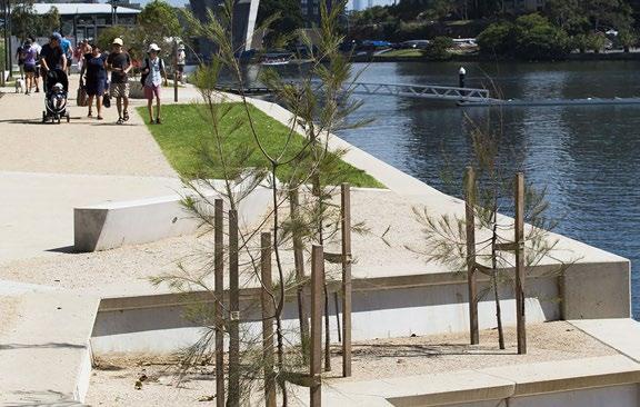
PRECEDENT STUDY GLEBE FORESHORE, CITY OF SYDNEY
In 2006, The City of Sydney redeveloped the foreshore along Rozelle Bay and Blackwattle Bay by connecting a sequence of existing and new open spaces. The foreshore, now known as ‘The Glebe Foreshore Walk’, was linked by pedestrian and cycle path along Blackwattle Bay and Rozelle Bay. Features such as paths, seating, walls, new water stairs, the construction of new habitats, including mangroves, terrestrial habits, and intertidal habitats, beach access, decks, pontoons, ramps, bioswales and items of heritage and archaeological significance were incorporated along the foreshore, all contributing to the increased usability of the area.


