
Broad River | Courts of Woodhurst | Creighton Home | Fairfield | Fairfield Terrace Belmont Fairmont | Foster Park | Harrison Hill | Hoagland Masterson | Illsley Place | Oakdale Poplar | Sherwood to Pettit | South Wayne | Southwood Park | West Rudisill Williams Woodland Park | Woodhurst City of Fort Wayne | Packard Area Planning Alliance PACKARD AREA NEIGHBORHOODS PACKARD 2030

PACKARD2030 City of Fort Wayne, Indiana May 2023


Clear Sidewalks for a neighborhood stroll Josh Campbell, City of Fort Wayne Packard 2030 1 TABLE OF CONTENTS The Planning Process 05 Plan Recommendations 37 History of the Packard Area 07 Neighborhood Revitalization 39 Existing Conditions 17 Neighborhood Character 51 Neighborhood Public Realm 57 Packard 2030 is a production of the City of Fort Wayne Community Development Division in partnership with the packard Area Planning Alliance Resolution for Adoption 64
With 18 unique and distinct neighborhoods located just a few minutes from the heart of downtown Fort Wayne, the Packard Area Planning Alliance has long served as a model for independent neighborhoods working together to achieve common goals. Since their founding almost two decades ago, volunteer neighborhood leaders have collaborated with the City of Fort Wayne on several projects that continue to improve the overall quality of life in our community. These neighborhoods have passion, drive, and ingenuity that help make Fort Wayne a four-time award-winning All American City.
This project, Packard 2030, is a testament to the work of these neighborhoods and their leaders. Goals, strategies, and action steps, inspired by over 1,500 residents, can be found throughout the Plan. Even though COVID-19 disrupted in-person meetings and engagement opportunities, the residents and businesses of the Packard Area stepped up to the plate, looking out for one another and working together to craft a vision for the next 10 years for their neighborhoods. Packard 2030 is truly one of the most engaging plans the community has ever adopted.
I am honored to serve the Packard area as Mayor and applaud each person who had a role in this project. Engaged neighbors, supportive businesses and organizations, and fearless leaders working to make Packard 2030 successful will be a blueprint for our hundreds of neighborhoods across Fort Wayne.

The 5th District is the historic heart of Fort Wayne, with an eye to the future. I am proud to have served the central part of Fort Wayne since 2012. In that time, I have been blessed to work with dedicated and engaged neighbors and neighborhood leaders, all working together to maximize all aspects of the important part of the city that we all love. The Packard 2030 plan encompasses all the best of what these neighborhoods and these neighbors have to offer.


The Packard Area is made up of 18 engaged neighborhoods, with this project initially led by Kody Tinnel and Holly Munoz and adopted through the leadership of Sierah Barnhart and Ben Ruhl. Occurring throughout COVID-19, there was concern that community participation would suffer, but there were over 800 responses to the community survey, 40 neighborhood walks and meetings, and 50 oneon-one stakeholder interviews. More than 1,500 people were involved in ensuring that the Packard 2030 plan is one of the most engaged plans the community has ever adopted, focusing on sustainability and equity, with a framework of revitalization, culture, and public realms.
I applaud everyone involved with the creation, adoption, and implementation of this plan and I look forward to continuing to see the Packard area thrive as part of the core of the Fort Wayne.
Packard 2030 2
GEOFF PADDOCK DISTRICT 5 COUNCILMAN TOM HENRY MAYOR OF FORT WAYNE
PACKARD 2030 ACKNOWLEDGEMENTS
Many people, organizations and businesses throughout the Packard Area Planning Alliance and the City of Fort Wayne gave time and expertise to create this multi-phase neighborhood plan.
City of Fort Wayne Elected Officials
Tom Henry Mayor
Geoff Paddock
5th District Councilman
Michelle Chambers
At Large Councilwoman
Tom Freistroffer
At Large Councilman
Glynn Hines
At Large Councilman
City of Fort Wayne Staff
Karl Bandemer Deputy Mayor
Nancy Townsend
Community Development Director
Dan Baisden
Neighborhood Planning & Activation
Réna Bradley
Neighborhood Planning & Activation
Josh Campbell
Neighborhood Planning & Activation
Bernadette Fellows
Neighborhood Planning & Activation
Sherese Fortriede
Planning & Policy
Megan Grable
Neighborhood Planning & Activation
Creager Smith
Historic Preservation
Packard 2030 Additional Resources
Anna Baer Public Works
Chris Carmichael
Property Management
Nathan Hubartt
Fmr. South Wayne Neighborhood President
Nick Jarrell
Public Works
Alec Johnson
Parks & Recreation
Nathan Law
Community Development
Kelly Lundberg
Community Development
Stacey Matthews
Fmr. Illsley Place Neighborhood President
April Rivas
Office of the Mayor
Chad Shaw
Parks & Recreation
Tom Tiernon
Fmr. Oakdale Neighborhood President
Kyle Winling
Public Works
Patrick Zaharako
Public Works
Packard 2030 Committee
Sherry Early-Aden
Sarah Aubrey
Sierah Barnhart
Carlos Brooks
Clydia Early
Sandy Garcia
Rebecca Gremaux
Holly Munoz
Arline Nation
Lyndsay Sheets-Perez
Dan Swartz
Kody Tinnel
Packard Area Leadership
Sierah Barnhart
Packard Area Planning Alliance
Ben Ruhl
Packard Area Planning Alliance
Rebecca Gremaux Packard Area Planning Alliance
Lyndsay Sheets-Perez
Packard Area Planning Alliance
Zac Brough Woodhurst
Nicholas Bucher Courts of Woodhurst
Joleen Holly Fairmont
Alex Kraus
Harrison Hill
Melissa Kurten Oakdale
Andy Kurzen
South Wayne
Jody Lent
Foster Park
Steve McCord
Southwood Park
Shaleen Moriarity
Fairfield Terrace Belmont
Holly Munoz Fairfield
Arline Nation
Hoagland Masterson
Dawn Parnin
Creighton Home
James Sack West Rudisill
Terri Stumpf
Williams Woodland
Olivia White
Illsley Place
Packard 2030 3
WHAT IS PACKARD 2030
Packard 2030 is a planning document which provides a shared vision and direction of 18 neighborhoods located in the southwest urban core of the City of Fort Wayne. Made up of homes averaging over 100 years old, the Packard area is rich with history, and a vibrant culture that the community looks to preserve and enhance while welcoming the future. In the following pages, you will find that this plan was created to:
• Engage the residents and stakeholders of the Packard area to identify and prioritize needs and aspirations
• Establish a shared vision that can guide the 18 neighborhoods of the Packard area
• Celebrate the Packard area’s history and culture and discover its unique personality
• Develop a set of goals and implementation strategies that will guide planning and development activities, neighborhood design, public improvements and future investments
• Provide guidance to neighborhood associations in the Packard Area, the City of Fort Wayne, decision-makers, public agencies, developers, investors, for-profit corporations and non-profit organizations
WHO DOES IT INCLUDE
• Neighborhood Associations
• City Leaders and Staff
• Investors, Developers and Business Owners
• For-Profit Corporations & Non-Profit Organizations
WHAT DOES IT INCLUDE
• Neighborhood History and Existing Conditions
• Neighborhood Revitalization
• Neighborhood Character
• Neighborhood Public Realm
HOW
TO USE PACKARD
2030: The plan uses a broad framework for future initiatives, and serves as a starting point for more detailed planning and public engagement as each project is implemented. The action steps in this plan will continually evolve to meet the changing needs of the Packard area. The maps, diagrams, graphics, photographs, and charts presented with Packard 2030 are illustrations of its key features. These items are not intended to represent the exact results from the implementation of the plan, but merely provide a representation of the community desires heard and collected through the engagement process. The scope, final form, and timing of Packard 2030 will depend on many factors including but not limited to organization priorities, available resources and market demand.
Packard 2030 4
THE PLANNING PROCESS
The Packard 2030 planning process began in the winter of 2020 at the Packard Area Planning Alliance’s request to update the previous 2005 Packard Area Plan. Neighborhood leadership was concerned that many elements of the previous plan were outdated and no longer reflected the current demographic, socioeconomic or geographic footprint of the expanded Packard Area.
With a steering committee made up of Packard Area Planning Alliance leadership and a few additional neighborhood leaders in place, the Packard 2030 plan kicked off just one month before the onset of the COVID-19 Pandemic. The interruption required the Packard Area Planning Alliance and the steering committee to take a different and elongated approach to the planning process.
At the heart of Packard 2030 are robust stakeholder and resident engagement processes. Over the past two years, thousands of community members, from youth to seniors, renters to property owners, workers, business owners, and elected officials, participated in over 200 meetings and workshops. Engagement strategies included online and print surveys in multiple languages, COVIDsafe public events, working group meetings, neighborhood walks, and meetings in various locations, including Williams Woodland, Woodhurst, Fairmont, and Hoagland Masterson.
Description of Planning Tools provided below:
Resident Survey: In order to gather perceptions and concerns about the Packard Area, digital and paper surveys were widely distributed to residents and business owners. The surveys garnered eight hundred (800) responses. Surveys were provided in English and Spanish and were distributed through various media to ensure ample coverage of the Packard Area.
Stakeholder Interviews: Over sixty (60) one-on-one stakeholder meetings were conducted to gain additional insight into challenges and priorities for neighborhoods in the Packard Area. The stakeholder meetings were primarily conducted in May and June 2020. Interviews used a ‘snowball sample,’ meaning that the first residents contacted were asked to provide an additional stakeholder to interview until sixty (60) total interviews
were completed. Long-time and short-term residents, business owners, non-profit executives, and leaders of institutional facilities participated, representing all neighborhoods in the Packard Area.
Neighborhood Walks and Meetings: The City’s Neighborhood Planning and Activation staff attended nearly forty (40) neighborhood walks and neighborhood association meetings throughout the two-year planning time frame. At each event, staff spoke with residents and business owners to better understand their concerns and vision for the neighborhood. Staff used these opportunities to complete field assessments of neighborhood conditions.
Public Open House: Four public open house events were then held at Wunderkammer Company in January 2022 to present the initial findings and recommendations to the community. Nearly one hundred (100) residents provided feedback, and the recommendations outlined in this plan are what emerged from the Open House responses.
Engagement Outcomes: Over one thousand five hundred (1,500) residents were involved in the Packard 2030 Plan making it one of the most robust engagement projects the city’s Community Development Division has undertaken. A broad cross-section of the community articulated challenges and needs that Packard Area residents currently face and foresee. Together they set goals and objectives, generated ideas and policies, and crafted ideas for longterm investments to help the Packard Area thrive for generations.
Planning Lens
Sustainability: Planning for sustainability means that the activities we undertake today will not compromise our resources (both human and natural) in the future. With sustainable planning, people, buildings, neighborhoods, the economy, and public services will be ready to withstand and adapt to changes in the years to come.
Packard 2030 5
Equity: Planning for equity and inclusion means that the steps we take must account for the “larger community,” rather than the few that are often the most vocal. Ensuring justice and fairness allows for ethical and fair access to a high quality of life regardless of race, gender, income, ability, orientation, etc. To do so we must recognize planning practices that have had a disparate impact on specific communities while actively working with residents to create communities where all can thrive.
Planning Framework
Neighborhood Revitalization: The ultimate goal of neighborhood revitalization is to improve the quality of life for residents. In Packard 2030, Neighborhood Revitalization focuses on housing, economic opportunities, and beautification.

Neighborhood Culture: Throughout the planning process, residents emphasized that the area’s historical feel and diversity are part of the Packard Area’s success. Neighborhood Culture focuses on preserving historic assets, celebrating cultural diversity, and promoting inclusivity in each Packard Area neighborhood.
Neighborhood Public Realm: The streets, alleys, sidewalks, trails, bike lanes, and parks work together seamlessly to ensure residents have access to Fort Wayne destinations while providing a sense of place. Neighborhood Public Realm focuses on these critical infrastructure investments and creating ample open space.
Packard Annual Retreat
Packard 2030 6
Rachel Von, Input Fort Wayne
THE HISTORY OF THE PACKARD AREA
Our architecture reflects truly as a mirror.
Packard 2030 7
” Louis Sullivan
Packard Area begins
Development of what is now known as the ‘Packard Area’ began c. 1855, beginning with the area south of downtown and the Pennsylvania Railroad tracks. Shortly after the railroad was built, the area along the corridor north and south of the tracks was filled with industries that could supply the railroads and that took advantage of the shipping available by rail. Examples of these early industries include the Bass Foundry and the Olds Wagon Works. Simultaneously dense, walkable neighborhoods of small plats and narrow streets along the tracks and between the factories began to develop. The area immediately South of the tracks between Calhoun and Broadway was known as ‘Irishtown’ due to its high concentration of Irish settlers. To support this growing community, St. Patrick’s Catholic Parish was founded on South Harrison Street in 1889.
Outside of the Irishtown area, prominent Fort Wayne civic, business, and industry leaders and their families owned numerous country estates, especially between the St. Mary’s River and Hoagland Avenue. The area was considered the earliest form of suburban
Broadway Avenue, the first major roadway development, remains the most traveled street in the Packard Area today. Broadway Avenue traversed south of Fort Wayne and crossed the St. Mary’s River, connecting Fort Wayne to Bluffton. The area immediately south of the bridge, across from the entrance to Foster Park, was the site of the earliest industrial development and the first waterpowered mill in Allen County. Constructed in 1827 by James Barnett and Samuel Hanna, the mill went through a succession of owners and after a devastating fire destroyed the original structure, a brick building was built. In 1888 the brick structure was also destroyed by fire, and the site was abandoned for industrial use. Decades later, perhaps the most crucial 19th-century business development in the Packard area was the Packard Organ and Piano Factory. Isaac Packard’s Chicago factory was destroyed in the infamous 1871 Chicago fire, which led Packard to move his manufacturing operation to Fort Wayne. He constructed a new factory on Fairfield Avenue, which at the time of construction was isolated from the fire dangers of railroad lines and other factories. The plant operated
development. Those who could afford to do so moved to the country for fresh air and lush gardens. They took a buggy or carriage into the city for work or to care for their professional or business interests. South of what is now Creighton Avenue were several small farms and woodlands. The Allen County Farm was located in the central part of what is now the Packard area between 1848 and 1853. After the farm was relocated, the acreage was divided into 16 Wayne Township out-lots and sold. By the early 1870s, residents of the area had formed a loose-knit suburban community called ‘South Wayne.’ As more of the area was platted, cleared of most of its trees, and drained of swamplands, it became more attractive for residential and industrial development.
Packard Piano Company, 1906

Allen County Public Library Digital Collections
into the early 1930s; it was later demolished to develop the park at the center of the Packard Area, which opened in 1937. In 1886 the Jenney Electric Company moved to a location just north of the South Wayne and Irishtown areas at the intersection of Broadway and the Pennsylvania railroad tracks. This company, which later became General Electric, was one of the largest employers in the city. The development of industries in this area encouraged further residential development to the south, especially the area referred to as South Wayne.
Packard 2030 8
South Wayne and Suburban Development
As the number of industries increased, the population followed. In South Wayne, there was strong interest in the annexation of this suburban area by the City of Fort Wayne. Years before, in 1872, a group of approximately twenty-five prominent residents of the area and the Fort Wayne Organ Company petitioned the Allen County Commissioners for incorporation. The petition read,”[that] a settlement south of the City of Fort Wayne containing 350 voters be incorporated as the town of South Wayne.” The Fort Wayne city attorney also appeared before the Commissioners to object and persuaded the Commissioners to defer action. The Fort Wayne City Council attempted to prevent the incorporation of South Wayne by voting to annex the area. The Allen County Commissioners subsequently dismissed the petition to incorporate South Wayne. A lengthy court battle ensued, but ultimately, the Indiana Supreme Court ruled in favor of the incorporation of South Wayne. After a delay of sixteen years, the town was incorporated in 1888. In 1894, after negotiations between the Town of South Wayne and the City of Fort Wayne, South Wayne was annexed into Fort Wayne. Fort Wayne streetcar lines and utilities were then extended south into South Wayne, and a new South Wayne School was built at the present-day location of South Wayne Elementary School.
After annexation the availability of city services made the former South Wayne area even more attractive for continued residential development. With the Fort Wayne streetcar system extended west on Creighton Avenue., south on South Wayne Avenue, and south on Broadway Avenue, new homeowners had greatly improved transportation access to the city. This sparked a boom in land development and home construction after 1894, which continued until 1954.
Much of the development pattern along Broadway Avenue between Scott Avenue and Oakdale Drive is “Streetcar Suburban.” Very long blocks with narrow lots platted allow several houses to be built while also allowing most people to have the shortest possible walk to the streetcar line, resulting in faster commutes to and from work. The suburban streetcar pattern is also evident on both sides of South Wayne Avenue from Home Avenue south to Pasadena Drive. The Sherwood to Pettit neighborhood exhibits this form; however, the streetcar was never extended south on Calhoun Street to reach the platted area in 1911. Although the Williams Woodland Park and Fairfield neighborhoods also reflect the development patterns of Streetcar Suburbs, most of these areas were never within the Town of South Wayne. Instead, these neighborhoods developed with influence from the earlier Fort Wayne streetcar lines located on Calhoun Street and Creighton Avenue.
Industrial and Business Development
Many neighborhood service businesses were established in the Packard area, primarily in the period from 1894 to about 1955. The community’s daily needs were met by mom and pop stores and
later by chain stores. Commercial buildings were often built in clusters along the primary north-south transportation routes served by streetcar lines. Broadway Avenue and Calhoun Street were the primary commercial corridors; however, clusters of commercial buildings were also found on Fairfield and South Wayne Avenue. Isolated neighborhood grocery stores could be found embedded in the neighborhood streets. As the automobile became the most common mode of transportation, development on the corridors shifted to auto-oriented businesses.
The establishment of two vital institutions and a major city park provided some of the amenities needed to support a thriving residential area. Lutheran Hospital was established in the former home of Judge Lindley M. Ninde (a country estate named “Wildwood”) at Fairfield and Wildwood Avenues in 1904. Lutheran Hospital experienced a progressive expansion from 1904 to about 1981. This created a campus of buildings, parking lots, and garages that filled a 12-acre site located between Fairfield and South Wayne Avenues. The facility was significant in developing the practice of medicine in Fort Wayne, providing leadership in nursing training, pediatrics, and coronary care. In 1992 Lutheran Hospital moved its operations to a new suburban campus located near Interstate 69, and in 1995, the hospital was sold to private investors, while the old facility remained under the ownership of the Lutheran Foundation. After a planning process that included the area neighborhood associations, the old hospital was demolished, and the private “Lutheran Park” was developed on the site. In January 1905, the Fort Wayne Bible Training School (later Fort Wayne Bible College) was dedicated at the Northwest corner of South Wayne Avenue and Rudisill Boulevard. The school was the national center of training and education for the Missionary Church Association. In 1992, Summit asked Taylor University of Upland, Indiana, to take over the campus operations allowing Taylor University to return to the city. However, Taylor’s leadership decided to close the campus at the end of the 2009 academic year and sell the Fort Wayne campus. Ambassador Enterprises purchased the campus and it is now called “The Summit.”
Parks and Boulevards
A report published in 1909 profoundly affected the Packard Area’s development, especially south of Rudisill Boulevard. Fort Wayne civic leaders first embraced the City Beautiful movement with the adoption of the “Report of Charles Mulford Robinson for (the) Fort Wayne Civic Improvement Association.” The Robinson Plan was a vision for the future development of Fort Wayne. The vision was fulfilled in 1911 when nationally significant Landscape Architect George Kessler designed the Fort Wayne Park and Boulevard System. The Kessler Plan created the boulevards as a circulation system around the city that would easily accommodate the speeds of the automobiles in the first decade of auto production. The boulevards were wide, straight, and lined with London Plane Trees, providing a scenic drive or walk to the parks proposed to anchor each end of the boulevards at the city’s four corners.
Packard 2030 9
Foster Park, built on land donated in 1912 by brothers David and Samuel Foster, was the first park developed to fulfill the vision. Portions of the Oakdale Neighborhood were platted in ways influenced by the Kessler Plan. Still, the much more significant developments of Harrison Hill and Southwood Park took full advantage of new, creative development styles that were designed for ease of automotive access, but incorporated street curvature to accommodate the terrain and existing trees.
The Great Depression led to the demise of the only large-scale industrial plant within the Packard area, the Packard Piano and Organ Company. In 1937 The City of Fort Wayne Parks Department obtained funding from the federal Works Progress Administration to demolish the Packard factory and develop the site as Packard Park. Packard was one of three major parks found within the Packard area, along with Foster Park and Kettler Park.
Neighborhood Change
The Packard area experienced steady growth, with residential development moving south until the Great Depression began in 1929. As a result single-family housing was converted to apartment units in the Irishtown, Creighton-Home, and Broad River neighborhoods. During World War Two, the need for housing sustained the trend of apartment conversions well into the 1950s. In other neighborhoods, Fairmont in particular, the Great Depression caused a change in housing types. In the 1930s a group of scattered houses between Rudisill and Pettit was built at the rear of the lots rather than at the front, inconsistent with the setbacks of the adjoining houses. Instead these houses aligned with the adjacent detached garages, so that better, permanent houses could be built at the front of the lot when economic conditions improved. However, the good intentions were never fulfilled, and simple houses remain at the rear of lots where detached garages were typically located.
By the early 1970s, the Packard area was a mature residential area with housing of a variety of ages and types. Housing in some areas of the northern neighborhoods, such as Irishtown, CreightonHome, Williams Woodland Park, Fairfield, and South Wayne, was increasingly converted to multi-family units and rentals. Some southern Packard neighborhoods such as Southwood Park and Woodhurst saw the last houses built in the early 1970s. Commercial areas along the transportation corridors continued to be important in providing the service needs of neighborhood residents. As suburban residential and commercial growth in the Fort Wayne area accelerated in the 1970s and 1980s, the Packard area was impacted by the loss of neighborhood businesses. Continued suburban growth of the city and the aging of the housing stock and population, led to increased residential vacancy and demolitions from the 1980s to today.
The efforts of organized neighborhood associations in the Packard area began to gain momentum in the 1980s. The eighteen neighborhood associations have slowed or halted the deterioration of the neighborhoods, organized neighborhood development projects, and promoted community pride in the area. The formation of the Packard Area Planning Alliance in 2003 was a historic step which unified the efforts of neighborhood associations in the Packard area as a whole. Yet, the individual associations also remained dedicated to improving their respective neighborhoods. The Packard Plan was adopted in 2005. The Packard 2030 Plan and the continued efforts of the Packard Area Planning Alliance build upon the last two decades of momentum.
ARCHITECTURAL SIGNIFICANCE
The neighborhoods of the Packard Area contain a wide variety of folk, vernacular, and architect-designed homes built from the mid-nineteenth century to the current day. The structures are generally older north of Creighton Avenue near the railroad lines in Irishtown,, and newer to the south beyond Pettit Avenue in the Woodhurst neighborhood. While the age, form, and style of structures in the Packard Area varies, there is continuity among the setback, style, scale, size, detailing, and other character-defining features. Transitions of housing typologies are gradual, with few jarring contrasts. Houses in the area are generally two stories in height, although there are one-story and one-and-a-half-story houses.
Harrison Hill Neighborhood
Josh Campbell, City of Fort Wayne
Most architectural styles built in Fort Wayne from the 1860s to the 1960s are found within the Packard Area. Gothic Revival is the oldest architectural style present in the area. In the older neighborhoods
Packard 2030 10
there are numerous examples of the Queen Anne style. Other common styles are Colonial Revival, Craftsman, Tudor Revival, and American Foursquare. The area also contains rare examples of Richardsonian Romanesque, Neoclassical, Mission, Prairie, Spanish Eclectic, French Eclectic, and Art Moderne architecture. Mid-century modern ranch and contemporary homes are plentiful in southern parts of Southwood Park and the Woodhurst neighborhood. A few ready-cut houses manufactured by Sears-Roebuck and other companies have been identified.
Folk style, also called vernacular architecture, is prevalent in the Packard Area. The style is built by carpenters and builders who lack specific architectural training and instead design and construct based on ethnic heritage, local standards, or tradition. In folk and vernacular structures, the intended function often dictates the design, size, shape, building methods, and construction materials. Nineteenth-century vernacular housing can be found in the Irishtown, Broad River, Williams Woodland Park, Creighton-Home, Historic South Wayne, and Oakdale neighborhoods. Much of the vernacular homes were developed while the area was incorporated as South Wayne. The most common vernacular housing types in the Packard Area are gable front and gabled houses and cottages. Some commercial structures along Broadway Avenue and Calhoun Street may also date to the same period. Some vernacular houses and commercial structures in the Packard Area could also be classified as popular architecture. Popular architecture appealed to the masses with traditional, familiar forms dressed in fashionable architectural styles; builders often mixed architectural forms in eclectic ways never intended by the originators of the styles.
Many structures in the Packard Area follow trends of academic architecture. Buildings in this category were designed by trained professionals who followed or even set architectural trends. Some of these structures may have been one-of-a-kind designs by local architects. Others were built by commercial or residential developers and were based on common plans that were used multiple times. Still other houses in the area were architect-designed from housing catalogs or even ready-cut kits. In academic architecture, considerations of style and aesthetics are as important as function, with the goal of balancing all elements. Because the emphasis on style and fashion is so great, architectural styles grew in popularity, evolved, and eventually fell out of fashion. Often early examples of the style are quite different from late examples.
Many of Fort Wayne’s significant architects and architectural firms designed structures in the Packard Area in the nineteenth and twentieth centuries. Architects whose work is found in the area include: Wing & Mahurin, Grindle & Weatherhogg, and J.M.E. Riedel. Guy Mahurin, Joel Roberts Ninde & Grace Crosby, Alvin M. Strauss, Leighton Bowers, and Pohlmeyer & Pohlmeyer. Unique community landmarks such as the Fairfield Manor and the Rialto Theater are among the more unusual buildings in the Packard Area. The Jacob Foellinger House, built c.1872 of brick construction at
447 West Wildwood Avenue, is Fort Wayne’s best example of an Italian Villa. The Grace Crosby House, c.1867, at 413 W. Dewald is an outstanding example of the Gothic Revival style. The Komito House on West Rudisill is one of few Art Moderne houses in Fort Wayne.
REDLINING AND INEQUALITY
In the 1930s, the federal Home Owners’ Loan Corporation created Residential Security Maps of most American cities, including Fort Wayne. These maps classified neighborhoods at various levels of investment risk. Neighborhoods that were ‘redlined,’ or given a grade of ‘D’, were not able to obtain home mortgages or small business loans from banks or the federal government. Grades were based on the age and condition of housing; transportation access; closeness to amenities; economic class; employment status of residents; and notably, ethnic and racial composition. Redlining is largely responsible for racial housing segregation nationally and locally.
One portion of the Packard Area was redlined in 1937, according to the University of Richmond’s Mapping Inequality Project. North of Masterson Avenue, section D3, was described as having “detrimental influences” of being “old, obsolete, near industry, warehouses and the RR’s [railroads]” and primarily made up of a “laboring class” and “40% foreign-born.” While there is no single solution to reverse the outcomes of redlining, its continual impact on the composition of Fort Wayne’s neighborhoods can be significant.
 Hoagland Masterson Neighborhood
Packard 2030 11
John Felts, City of Fort Wayne
NEIGHBORHOODS FILLED WITH HISTORY
The eighteen neighborhoods of the Packard area each have unique development patterns and identities. However, as a group, they demonstrate a transition from mid-19th century development methods of the railroad era in the north to organized city planning efforts of the jet age in the south. In between are neighborhoods designed to accommodate transportation modes ranging from pedestrians to streetcars, from the freedom of bicycles to the costs and responsibility of the automobile. The neighborhoods display remarkable diversity in residential architecture and range from the modest to the grand, often within the same neighborhood.
Irishtown - ALSO - Hoagland-Masterson and Poplar
Irishtown, also known as Hoagland-Masterson and Poplar, is the oldest area of Packard, stretching east-to-west along what were initially the Pennsylvania and Wabash railroad corridors. Individual developers created many small residential plats without cooperating with one another and led to irregular street patterns of short, narrow streets that did not align. This was not a significant concern for pedestrians but later created difficulty for automotive traffic. Because most early travels were by foot, the lots were small, and the houses were closely spaced. The area was primarily filled with simple cottages for working-class families. Due to a large concentration of working-class Irish families, the area was known as Irishtown. Store owners and professionals living near their workplaces led to commercial buildings and larger, more elaborate homes.. An example is August Becker, who lived in a grand house at 425 W. Williams Street [Hoagland-Masterson]. He walked one block to his store at Fairfield Avenue and Walnut Street. Becker’s home and store were located in the Fairfield Hill Commercial Historic District, an area eligible for the National Register of Historic Places. At least one country estate in Irishtown was later platted, much like the South Wayne area. The George and Mary Fox House at 803 Walnut Street was built c.1855 in the Greek Revival style [Poplar]. Located on the crown of a small hill, the house is oriented toward Taylor Street. When the acreage around the house was platted as the Fox Addition, Walnut Street was created between the Fox House and Taylor Street. As is typically the case with country estate homes, the lot is much larger than others in the Fox Addition.
Broad River
The Broad River Neighborhood retains the closest connections to the old town of South Wayne. In Broad River several country estates exhibited the truly rural character of South Wayne; parts of Thompson Ave. have the same feel near the St. Marys River. A Gothic Revival country estate house was moved to a lot at 1227-1229 Scott Avenue when the Thompson family platted the area in the 1890s.
An infill bungalow court in Broad River, Maple Place (1912), is the finest bungalow court in the Fort Wayne region. Due to these fine examples of historic architecture, the Maple-Park Historic District within the bounds of the Broad River neighborhood is eligible for entry with the National Register of Historic Places.
Creighton-Home
Creighton-Home Neighborhood is much like Irishtown in its development, with narrow streets and irregular grid patterns. However, it was the earliest portion of the Town of South Wayne developed in a high-density urban form. Much of the CreightonHome neighborhood was part of the Fairfield Farm, which Cyrus Fairfield platted and sold over a period of years. The area was developed due to its access to and influence by streetcars. The area between Fairfield and South Wayne Avenue developed later than the surrounding neighborhood due to a creek called Shawnee Run that dominated the lowland. After storm sewers drained the creek, Beechwood Circle and Beechwood Drive were developed. The Beechwood Historic District spans from the lowland north to Pierce Avenue and is listed in the National Register of Historic Places.
Williams Woodland Park
Williams Woodland Park was once part of the more extensive landholdings of Jesse Williams, a nationally significant engineer of canals, roads, and railroads. In the late nineteenth century, Williams Park was a private park open to the public. When the streetcar line was extended on Calhoun and Creighton Ave. the 1890s developed the residential area around the park. In 1903 the heavily-wooded Williams Park was platted into residential lots, and all the lots sold in one evening. With its park-like atmosphere and easy streetcar connections, this upper-middle-class area was developed quickly, finishing almost completely by 1915. Most of the neighborhood is a Fort Wayne Local Historic District and is listed in the National Register of Historic Places.
Historic South Wayne
The Historic South Wayne Neighborhood was first developed as the Allen County Farm between 1848 and 1853. After 1853 small farms likely inhabited it. Near Fairfield Avenue and Wildwood Avenue, in the eastern portion of the neighborhood was Judge Lindley M. Ninde’s country estate called Wildwood. It later became the site of Lutheran Hospital—now Lutheran Park. After Fort Wayne annexed South Wayne in 1894, the new South Wayne Elementary School was built in the neighborhood. At the same time, the extension of streetcar lines on South Wayne Avenue and Broadway Avenue led to dense residential development. The Historic South Wayne Neighborhood is a perfect example of the Streetcar Suburb. Very long blocks with narrow lots maximized the number of houses built while allowing the most people to have the shortest possible walk to the streetcar line. A small area in the center of the neighborhood is listed in the National Register of Historic Places, and a much
Packard 2030 12
larger area that stretches south into the Oakdale area is eligible to be listed.
The Wildwood Builders Company was formed in the South Wayne Neighborhood and built its first homes in the area. Wildwood Builders was the husband and wife team of Lee and Joel Ninde; Lee was the attorney and developer, while Joel designed functional yet beautiful homes for the twentieth century. Fort Wayne’s Grace Crosby, perhaps the earliest practicing female architect in Indiana, partnered with Joel Ninde to design modest, high-quality homes across the city.
Fairfield
The area of Fairfield Neighborhood west of Hoagland Avenue, was originally within the bounds of the incorporated South Wayne. The earliest evidence of development in the neighborhood occurred along Fairfield Avenue. One South Wayne country estate, the Jacob Foellinger House (c.1872) was developed along Fairfield Avenue; its current address is 447 W. Wildwood was a South Wayne country estate. Contemporary with the Jacob Foellinger House, the Packard Organ and Piano factory was built nearby on the land that is now Packard Park. The Packard factory led to limited working-class housing construction near the plant from the 1870s through the 1890s. As the city grew to the south, the remainder of the Fairfield area developed. The exception was the relatively small area of Shawnee Place. Wildwood Builders developed Shawnee Place in 1910 as a unique, small, one-block boulevard with pedestrian walks to connect adjacent streets to a fountain in the center. Shawnee Place is a Fort Wayne Local Historic District landmark. A larger area of the Fairfield Neighborhood is eligible for the National Register of Historic Places.
Historic Oakdale
The Oakdale Neighborhood is a mix of development types and time periods. French Street and a section of Kinsmoor Avenue have perhaps the oldest housing, with workers’ cottages built to support the Packard factory. Areas near Broadway Avenue have the Streetcar Suburb pattern. In the southern area of the neighborhood, near Rudisill Boulevard, Arcadia Court, Englewood, and sections of Oakdale Drive show the early influences of the City Beautiful movement. The stone piers that mark Arcadia and sections of Oakdale are characteristic of the City Beautiful era. Southern Oakdale was developing just as the Robinson and Kessler planning projects were shaping the development of residential areas in the early twentieth century, and these areas are transitional to neighborhoods south of Rudisill Boulevard. Much of the southern area of the Oakdale neighborhood is listed on the National Register of Historic Places.
Illsley Place
Illsley Place is an outstanding example of the infill development of a country estate property owner unwilling to sell the property for residential development. Illsley Place was platted in 1923 stretches from Broadway Avenue to Beaver Avenue. The plat is a relatively long and narrow area with lots on each side and a small center island. Brick piers welcome visitors at each end of the street. The street is lined with architecturally significant homes built from 1923 to c. 1960. The homeowners association, which is still active, was created in 1923. Illsley Place is part of the Illsley Place—West Rudisill Historic District, listed in the National Register of Historic Places.
West Rudisill
The West Rudisill Neighborhood was shaped by George Kessler’s Fort Wayne Park and Boulevard Plan. The plan outlined Rudisill Blvd. as the significant east-west connection across the city’s south side, linking Foster Park to what eventually became McMillen Park. Kessler designed Rudisill as a grand, wide boulevard lined with trees to enhance ones trip between the two, whether by automobile, bicycle, or foot. Residential developers embraced the opportunity to use Rudisill as a platform for upscale homes, particularly at the west end near Foster Park. Rudisill also became the home of major institutions, such as churches and the Fort Wayne Bible College. The western end of the West Rudisill neighborhood is within the Illsley Place-West Rudisill Historic District, listed in the National Register of Historic Places.
Historic Foster Park
The Foster Park Neighborhood was also shaped by the Kessler Park and Boulevard Plan. Platted in 1924 by the developers Hilgeman & Schaaf, the neighborhood is located adjacent to the intersection of Rudisill Avenue and Broadway Avenue and directly across from the primary entrance to Foster Park. The houses within the neighborhood exhibit architectural styles popular from 1924 and c.1958.
Historic Fairmont
Much of the Fairmont Neighborhood was platted in 1906 (just after the Bible College was founded directly to the north) and 1913. The neighborhood expansion allowed the South Wayne Avenue streetcar line to extend south of Rudisill Blvd. Fairmont is a continuation of the city grid pattern, with houses set back from the front of the lot and from each other. Fairmont is the home of a distinctive streetcar commercial district located on South Wayne at West Foster Parkway. Fairmont is listed in the National Register of Historic Places—within the Southwood Park Historic District.
Packard 2030 13
Historic Southwood Park NA
Southwood Park (originally South Wood Park) was largely developed by Hilgeman & Schaaf, starting with plats in 1917 and several more additions into the mid-twentieth century. Southwood Park was carefully designed to make use of the natural terrain and the existing trees to enhance the design and the configuration of the residential lots. The neighborhood also includes the large homes along Old Mill Road, developed as country estates starting c.1910. The Southwood Park Historic District, listed in the National Register of Historic Places, is one of the largest historic districts in Indiana. Many of the neighborhood’s houses were architectdesigned between 1905 to 1965 and are among the best examples of their respective styles within the city.

Historic Harrison Hill NA
The Harrison Hill Neighborhood was platted in 1915 by developers Hilgeman & Schaaf. The site was chosen as a strategic point in the city’s transportation system, at the intersection of George Kessler’s new Rudisill Blvd and the existing South Calhoun streetcar line. The neighborhood design was molded by the intersection of the new automobile-oriented street and the public transit streetcar system. Harrison Boulevard has a grand entrance with monuments at Rudisill Blvd. The larger, more expensive upper-middle class houses had large lots and long driveways to accommodate the automobile. The “radial” southern portion of the neighborhood has smaller lots with smaller middle-class homes to facilitate streetcar access. When the neighborhood was built, the developers provided an elaborate streetcar waiting station which allowed southern residents convenient access to the streetcars. Harrison Hill boasts a collection of residential architecture from 1915 to c.1958. The Harrison Hill Historic District is listed in the National Register of Historic Places.
Sherwood to Pettit NA
The Sherwood to Pettit Neighborhood was platted in 1911, as the McKinnieville Addition. It was platted with the expectation that the Calhoun Street streetcar line would be extended further south. Although the plat is a streetcar suburb in its form, the streetcar line was never extended south of Congress Ave. Despite a slow start in its development, the neighborhood is one of a handful of areas in Fort Wayne that enjoyed the ongoing construction of new homes in the 1930s. Many of the Tudor Revival and Colonial Revival houses in the area were built between 1935 and 1941. After World War Two, many remaining lots in Sherwood to Pettit were available. Hence, construction continued into the 1950s with ranch houses and a variety of mid-century modern homes built as infill. Two of Fort Wayne’s all-metal Lustron Homes are in the neighborhood. The Sherwood-Pettit Historic District is eligible for the National Register of Historic Places.
Fairfield Terrace/Belmont NA
Much like the McKinnieville plat immediately to the north, the Fairfield Terrace/Belmont area was also platted very early in the history of the city. The Belmont plat is a very large grid platted in 1909 that stretches from Pettit Avenue south to Paulding Road. The Fairfield Terrace plat of 1925 extended the neighborhood west to Fairfield Avenue. The Fairfield Terrace/Belmont area is a rare neighborhood that saw investment in simple new homes during the Great Depression. The neighborhood contains a variety of architectural styles, from simple folk types such as gable-front cottages of the 1910s to ranch-style houses of the 1960s and contemporary homes.
Woodhurst Community
The latest large, comprehensive residential development in the Packard Area was the Woodhurst addition, south of Pettit Avenue between Fairfield Avenue and the St. Marys River. Woodhurst was developed by the prominent developer John R. Worthman, starting in 1952 and additions created from 1954 to 1965. Woodhurst contains one of Allen county’s most significant mid-century modern residential architecture collections, with numerous examples of ranch, contemporary, and late Colonial Revival styles. Woodhurst also contains three outstanding contemporary churches, including the Neo-Expressionist style Unitarian Universalist Meeting House; the contemporary style Congregation Achduth Vesholom Temple (designed by A.M. Strauss); and the Peace Lutheran Church and School, designed with a mix of a Gothic Revival style school (Hugo Haeuser of Milwaukee) and an added Neo-Expressionist sanctuary (Charles Stade and Associates of Park Ridge, Illinois). The Woodhurst Historic District is eligible for the National Register of Historic Places.
Courts of Woodhurst
The Courts of Woodhurst is a condominium complex developed at the southeast corner of the Woodhurst neighborhood in 1973. The complex was designed by the architectural and engineering firm of Goebel-Miller Associates of Rocky River, Ohio. It has a central clubhouse and pool surrounded by comfortable townhouse units.
Woodhurst Community
Packard 2030 14
Josh Campbell, City of Fort Wayne
PRESERVATION AND PROTECTION
The Packard Area is a dense and diverse historic residential area with a variety of significant individual houses and buildings and numerous historic residential districts. The area has one of the richest collections of historic neighborhoods in the City of Fort Wayne, both in terms of neighborhoods with historic designations and those that are eligible for historic designation. The Packard Area has individual houses and commercial buildings registered with both the Fort Wayne Local Historic Designation and the National Register of Historic Places.
The Fort Wayne Historic Preservation and Protection Ordinance creates Local Historic Designations. Local Historic Designation may be applied to a single property or a group of properties, called a district. Upon designation, a design review process regulates proposed exterior changes by requiring property owners to obtain a Certificate of Appropriateness before a building permit can be issued or exterior work can begin. Local Historic Designation helps to monitor and control changes that occur to a district over time and ensures that the historic character of a property or district is preserved.
The National Register of Historic Places is the nation’s official list of cultural resources worthy of preservation. Authorized under the National Historic Preservation Act of 1966, the National Register is part of a national program to coordinate and support public and private identification, evaluation, and protection of historic and archeological resources. The register catalogs significant districts, sites, buildings, structures, and objects of American history, architecture, archaeology, engineering, and culture. The National Park Service administers the National Register with the assistance of the Indiana DNR-Division of Historic Preservation and Archaeology and the City of Fort Wayne as a Certified Local Government (CLG). Being included in the registry protects properties from the adverse effects of federally-funded projects; however, it does little to ensure the long-term preservation of the listing.
The Packard Area has two locally designated residential historic districts, The Williams Woodland Park and Shawnee Place Local Historic Districts. The area also has one small commercial historic district registered locally, The Fairfield Hill Local Historic District.
The Packard Area has eight residential districts listed in the National Register of Historic Places: Williams Woodland Park, South Wayne, Beechwood, Foster Park Neighborhood, Harrison Hill, Illsley PlaceWest Rudisill, Southwood Park, and the Oakdale Historic Districts. A ninth residential National Register district project will begin later in 2023.

The Local and National Register historic districts contain hundreds of architecturally and historically significant homes. The largest registered area is Southwood Park, while the smallest is Fairfield Hill. Much of the Fort Wayne Park and Boulevard System Historic District is also within the Packard Area.
Eighteen individual houses and buildings in the Packard Area have been designated local historic properties. Local Historic commercial designations include: the Broadway Theater, the Rialto Theater, Gerding’s Drug Store, and Hoosier Store #28. Some examples of residential Local Historic Designations are: the William & Edith Mossman House, three houses at the intersection of Creighton Avenue and Harrison Street, Fairfield Manor, and the Harry A. Keplinger House.
In addition to the districts and individual properties already designated, there are still more districts and individual buildings eligible for historic designation throughout Packard Area neighborhoods. Although home demolitions and alterations have occurred in most neighborhoods, most retain at least one area with historical significance and integrity. Areas eligible for entry in the local and national registries include: the Maple Place area, an enlarged Shawnee Place Historic District, an enlarged South Wayne Historic District, much of the Sherwood to Pettit Neighborhood, and much of the Woodhurst Neighborhood. Large areas of Packard previously listed in the National Register of Historic Places are eligible for Local Historic Designation.
Williams Woodland Neighborhood
Packard 2030 15
John Felts, City of Fort Wayne

Packard 2030 16
William
EXISTING CONDITIONS
Packard 2030 17
”
Holly Whyte
What attracts people most, it would appear, is other people.
IDENTIFYING STRENGTHS & OPPORTUNITIES
We have identified several strengths and opportunities that characterize the neighborhoods through research of both existing conditions and community engagement. In the first section, we recognize Packard’s strengths as assets which are seen as benefits to the neighborhoods. The second section, focuses on opportunities and stressors, which should be seen as areas where improvement could be made to enhance the quality of life in the Packard Area.
in Southwood Park. Meanwhile, Peace Lutheran Church in the Woodhurst neighborhood provides preschool education.
• Fort Wayne Public Library: The Shawnee Branch Public Library has served the needs of students and families seeking to expand their education for several decades. Current plans call for the relocation of the Shawnee Branch. The new location which will likely still service the needs of residents across the Packard Area.
Proximity to Downtown Fort Wayne: Proximity is often considered one of the essential ingredients in building great places, and the Packard Area’s distance from Downtown Fort Wayne is a strength of all its neighborhoods. Downtown Fort Wayne serves as the economic and cultural heart of Northeast Indiana, filled with vibrant small businesses, corporate headquarters, community organizations, and government entities. Each day, thousands of visitors and employees travel to and from the city’s center using corridors such as Broadway Avenue, Calhoun Street, and Fairfield Avenue. These corridors are important tools for economic development. Also due to its proximity to downtown, many Packard Area residents enjoy a short commute to and from work and other daily necessities.
Proximity to Cultural and Educational Institutions: The Packard Area has a rich history of cultural and educational institutions that support the needs of the greater Fort Wayne community.
• Fort Wayne Community Schools: Three primary schools are located throughout the Packard Area and serve the needs of students from Kindergarten through the 5th Grade: South Wayne Elementary, Fairfield Elementary, and Harrison Hill Elementary. In addition, South Side High School lies on the border of the Packard Area on South Calhoun Street.
• Private Educational Institutions: Several private educational institutions also support the population. Bishop Luers High School, one of the city’s two private Catholic high schools, is located directly across Calhoun Street from the FairfieldTerrace-Belmont Neighborhood. St. John’s Catholic School serves the needs of younger populations, strategically located
Historical Character of the Packard Area neighborhoods: The Packard Area is rich in developmental history, featuring neighborhood development patterns of all eras. From the late nineteenth century patterns in Hoagland Masterson, Poplar, Broad River, and Creighton Home to the mid-century modern additions of Woodhurst and Foster Park, these neighborhoods are a physical marker of time. The historic character of the Packard Area is a significant asset. As Fort Wayne continues to grow, residents who seek alternatives to the mainstream development options will seek historic neighborhoods such as those in the Packard Area, adding to its value.
Kessler Park and Boulevard: Rudisill Boulevard is a three-mile road connecting Foster Park in the Packard Area to McMillan Park in Southeast Fort Wayne. Developed by the Board of Park Commissioners in Fort Wayne, Rudisill was designed by famed landscape architect George Kessler. This landmark of the Packard Area features a wide road with two travel lanes, bi-directional bike lanes, a deep right of way, and a growing tree canopy.
Local Historic Districts: Sections of the Packard Area have received both local district and local property designations. Both designations provide security to property owners that their property will not be harmed by inappropriate alterations or construction on adjacent properties.
• Shawnee Place Historic District is listed for its unique planned design, cohesive architecture, and its association with the Wildwood Builders Company under the direction of the innovative husband-and-wife team of Lee J. and Joel Ninde.
Packard 2030 18
• Williams Woodland Park Historic District was established in 1985 and features a park-like atmosphere that encourages the retention of existing trees. The homes represent multiple architectural styles, with each house featuring distinctive design and attention to detail.
Individually Listed Local Historic Designation Properties include the following:
• Broadway Theater
• The Grace E. Crosby House
• Diffenderfer House
• Arthur Morgan Dodd & Anna Tiffany Dodd House
• Dyer, Flick & Tieman House
• Fairfield Hill Commercial District
• Fairfield Manor
• Harry & Jennie Fishack House
• George & Mary Fox House
• Gerdings Drug Store
• Hoosier Store 28
• Clyde A. Jackson House
• Harry A. Keplinger House
• Jack & Shirley Komito House
• Maple Avenue
• Dr. Robert & Susie McKeeman House
• William & Edith Mossman House
• Rialto Theater
• Rahe, Foster & Sack House
• Hiram B. Woolsey House
National Register Historic Districts:
• Beechwood Historic District is primarily located in the Creighton-Home neighborhood and includes small portions of both Williams Woodland and Fairfield. The district contains churches and large residences along Fairfield and a triangular park.
• Foster Park Historic District is a significant example of suburban subdivision design during the early decades of the 20th century. The district demonstrates key principles promoted by the City Beautiful Movement of an ideal place to live away from the downtown streets’ dirt, noise, and frenzy.
• Harrison Hill Historic District stretches from Rudisill Boulevard on the north to Pasadena Drive on the south. It features a wide boulevard and curvilinear streets that define the neighborhood’s character.
• Illsley Place-West Rudisill Historic District honors the former suburban estate of Frank Illsley Brown and Anna Bond Brown. The district is a linear layout with a tree-lined drive from Broadway Avenue to Beaver Street and a small roundabout at its center. The West Rudisill portion features large lots with unique architecture along the Kesslerdesigned boulevard.
• Oakdale Historic District began as a suburban enclave of country estates and was later platted and developed near the turn of the century. The neighborhood features stone and brick entrance markers. The homes are designed
with respect to height/setback ratio, lot size, landscaping, neighborhood delineation, and protecting open views.
• South Wayne Historic District features primarily homes constructed between 1910 and 1920 built in the Craftsman, Colonial Revival, and American Foursquare architectural styles.
• Southwood Park Historic District is shaped by Kessler’s historic Park and Boulevard plan. The neighborhood features distinct development patterns. The streetcar suburb in the northeast extends the city grid and lots with narrow setback lines to the naturalistic boulevards that hug the topography. Southwood Park is also unique in that it includes several Sears catalog homes.

Historic District
Josh Campbell, City of Fort Wayne
Ample Park and Recreation Space: The Packard Area contains many neighborhood parks, including a prime destination park on its western border. Parks are vitally important to establishing and maintaining a high quality of life, promoting health, and contributing to neighborhood residents’ environmental and economic well-being. Studies have found that living near a neighborhood park increases one’s likelihood of aerobic exercise, promotes mental healing, and benefits the environment and economy by removing 80 pounds of pollution from the air. Parks have been shown to improve property values, raise children’s test scores, reduce behavioral problems, and provide a critical ‘third space’ that promotes social capital and engagement.
• Packard Park: The 4.5-acre neighborhood park, situated in the heart of the Packard Area on Fairfield Avenue, is located on the former Packard Piano Company site. The park features futsal courts, a pavilion, and a playground.
• Foster Park: The oldest park in the Packard Area, Foster Park is located on land donated by Samuel and Colonel David N. Foster and their families. Today, at 255 acres, Foster is a regional park, meaning that while it serves the nearby neighborhoods, the park draws visitors from across Allen County. The park features three distinct pavilions, the Pawster Park Pooch Playground, a well-kept floral display, and the highly-regarded Foster Park 18 hole golf course.
Oakdale
Packard 2030 19
• Kettler Park: The 6.3-acre neighborhood park sits at the southern border of the Packard Area and serves residents in several nearby neighborhoods, including Fairfield-TerraceBelmont and Woodhurst. Kettler Park features a pavilion, basketball courts, tennis courts, and a playground.
• Bass Playground: The half-acre neighborhood playground has served the Hoagland-Masterson Neighborhood for over a century, with small expansions in the mid-1960s. Bass is located on Bass Street and features a playground, basketball court, and other neighborhood amenities.
• Miner Playground: The 1.8-acre neighborhood playground is located in the center of the Poplar Neighborhood on Dewald Street on the site of the former Miner School. Miner continues to serve nearby neighborhoods, including Creighton-Home and Broad River and features a well-attended neighborhood playground and ample open space.

• River Greenway: Considered a linear park, the River Greenway is a long, narrow park with limited access that connects several neighborhoods to the St. Mary’s River. The linear park winds along Packard’s west side.
Supporting the community’s strengths are a series of opportunities in which the neighborhoods can build on:
Urban Corridors: Restaurants, ice cream parlors, laundromats, service stations, and unique locally-owned businesses have called the urban corridors of the Packard Area home for over a century. Connecting residents both from within the neighborhoods and the edges of the city, the Broadway, Fairfield, and Calhoun corridors serve as a gateway to downtown Fort Wayne. In many cases, they also serve as commercial nodes for the nearby neighborhoods. Enhancing the corridors through facade improvements, public art, beautification efforts, and increased accessibility is important to ensure neighborhood vibrancy.
Cultural History (Irishtown): Fort Wayne’s historic Irish settlement is located in the northeastern Packard Area, overlapping primarily with the Hoagland Masterson neighborhood and portions of the Poplar Neighborhood. Packard 2030 will refer to this area as Irishtown. The area spans from St. Patrick’s Church on Harrison Street, dedicated in 1891, to the soon-to-be-installed Irishtown Plaza at the intersection of Taylor and Fairfield. When the area’s cultural history is celebrated, it can provide a significant economic impact and investment boost for members of the neighborhood(s).
Proximity to Electric Works: Since 1893, General Electric’s industrial campus was the site of several ground-breaking innovations in electrical apparatus, fractional electrical motors, and electrical transformers. For a period of time the company employed nearly 40% of the city’s workforce. For the past few decades, the site sat vacantly, deteriorating and serving as a reminder of Fort Wayne’s industrial past. Today, the campus is in a flurry of new construction spanning 39 acres, featuring 18 buildings and over one million square feet of space. The new Electric Works hosts a Science, Technology, Engineering, Arts, and Mathematics (STEAM) High School for Fort Wayne Community Schools, the new headquarters for Do It Best Hardware, and dozens of new offices, storefronts, and community amenities. Although located in nearby West Central, the proximity to Electric Works is a strategic opportunity for the Packard Area.
Miner Playground, Poplar Neighborhood
Josh Campbell, City of Fort Wayne
Arts Community: A study completed by Wunderkammer Co. in the past decade found that a large portion of Fort Wayne’s Creative Class resides within the boundaries of the 46807 zip code, which makes up most of the Packard Area. According to the Creative Census, respondents tend to be highly educated and have a significant background working in design. Supporting the growing arts community in the area can have several positive impacts, including developing a creative economy and establishing leaders
Packard 2030 20
eager to shape the community’s future. The neighborhood(s) near Wunderkammer Co. and along the Fairfield Avenue Corridor provide significant promise for the future of the Packard Area.
Housing Burden: The Office of Housing and Urban Development (HUD) defines ‘Housing Burden’ as when residents spend more than 30 percent of their income on monthly housing payments. The cost of shelter is deemed to be severe when one spends more than 50 percent of their income on rental or mortgage payments. Households that spend a disproportionate share of their income on housing often have difficulty affording necessities to live a healthy life, such as food, clothing, transportation, and medical care. Strained household budgets can impact the greater neighborhood by
• Limiting Resources for Housing Maintenance and Upkeep
• Reducing Resident Capacity for Volunteering and Fundraising
• Decreasing Capacity to Support Local Businesses
The Packard Area experienced a dramatic increase in housing burden during the 2008 recession. Homeowners with a mortgage in Census Tract(s) 20, 21, 25, and 26, and renters in Census Tract(s) 26 and 32 saw the most significant increase in housing burden. With an overall increase in median household income, the housing burden started to soften between 2010 and 2020. Still notably homeowners with mortgages in all but one census tract became more housing burdened than they were in 2000, and Census Tract(s) 21 and 32 remain significantly higher than in 2000. For renters, those classified as burdened have remained relatively stable, but alarmingly in Census Tract 25 the rate is severe. As housing costs rise nationally, Packard Area neighborhoods should work to reduce the housing burden among their residents by encouraging partners to provide financial literacy programs and build additional housing through infill development.
Vacant Housing Units: Of the over 8,000 housing units in the Packard Area, nearly 14% remain vacant. This percentage does not include the number of vacant parcels scattered throughout the area. Vacant and neglected structures, along with lots that are overgrown, abandoned, and filled with rubbish, are often hard on neighborhoods. Vacant properties can attract criminal activity, create a sense of insecurity and instability, and further a negative perception of the neighborhood. While vacant lots exist in virtually every city, neighborhoods can create adaptive reuse projects to repurpose these spaces for the benefit of the neighborhood or seek housing infill.
Poorly Maintained Housing Stock: Since the 1970s, the population of the Packard Area has decreased due to a decrease in family size and suburbanization attracting wealthy individuals away from the center of the city. In virtually every community in this scenario, portions of the existing housing stock and commercial properties fall into functional and aesthetic disrepair. This cycle exacerbates vacancy problems by reducing property values and decreasing neighborhood stability. Programs that aim to support housing rehabilitation, especially for owner-occupied properties that are either financially or mobility burdened, have positively impacted other communities. While not a fix-all solution, home repair programs could positively impact the Packard Area. Additional solutions include neighborhoods building strong relationships with property owners, including landlords, increasing confidence through small beautification efforts, and working with City and County officials to ensure properties meet existing zoning and neighborhood code requirements.
Rising Home Prices: The neighborhoods of Packard are builtout, meaning that much of the construction is complete, and the likelihood of building a new neighborhood is rare. Due to the Packard Area’s proximity to downtown and emerging amenities, and the overall shortage of housing in the market, the cost of housing and rent continues to rise. Ensuring opportunities for residents to remain in the neighborhood, no matter their age or financial ability, assists in building neighborhood stability. Welcoming additional infill and working toward solutions that combat displacement should be a priority for Packard Area neighborhoods in the decade to come.
Absentee Landlords/Property Owners: With over one-quarter of the Packard Area’s housing units classified as rentals, ensuring that landlords maintain their properties to a high standard is an important factor in improving the physical and social wellbeing of neighborhood residents. Bridging relationships between the neighborhood associations, property owners, and residents is necessary to ensure the Packard Area is a vibrant and welcoming place to work, live and play.
Neighborhood Capacity: Nearly three-quarters of Packard Area neighborhood associations are voluntary, meaning there are no dues or property requirements codified to promote participation or support association efforts. With financial and volunteer capacity constraints placed on a majority of the associations and their leadership, the ability to move ideas into project success stories can be limited. These limitations can lead to neighborhood apathy, burn-out, and associated social capital and property maintenance decline. Ensuring a strong, diverse, and inclusive Packard Area Planning Alliance where more residents have time and capacity to contribute is an important first step in growing and supporting neighborhood capacity.
Packard 2030 21
NEIGHBORHOOD DEMOGRAPHICS
The following demographic information, extracted from the US Census Bureau, uses Census Tract level data and has been compiled and analyzed to provide characteristics of the Packard Area. This information provides valuable insight to aid in formulating some of the recommendations in this plan and future planning efforts.
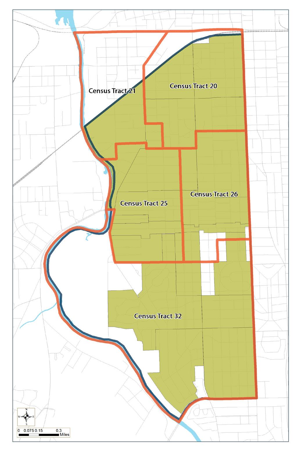
CENSUS TRACT 20
• Creighton Home
• Hoagland Masterson
• Broad River
• Broad River
• Creighton Home
• Fairmont
• Foster Park
• Illsley Place
• Fairfield
• Harrison Hill
• Oakdale
• Courts of Woodhurst
• Fairfield Terrace Belmont
• Fairmont
• Poplar
• Williams Woodland
CENSUS TRACT 21
• Creighton Home
CENSUS TRACT 25
• Oakdale
• South Wayne
• Southwood Park
• West Rudisill
CENSUS TRACT 26
• West Rudisill
• Williams Woodland
CENSUS TRACT 32
• Sherwood to Pettit
• Southwood Park
• Woodhurst
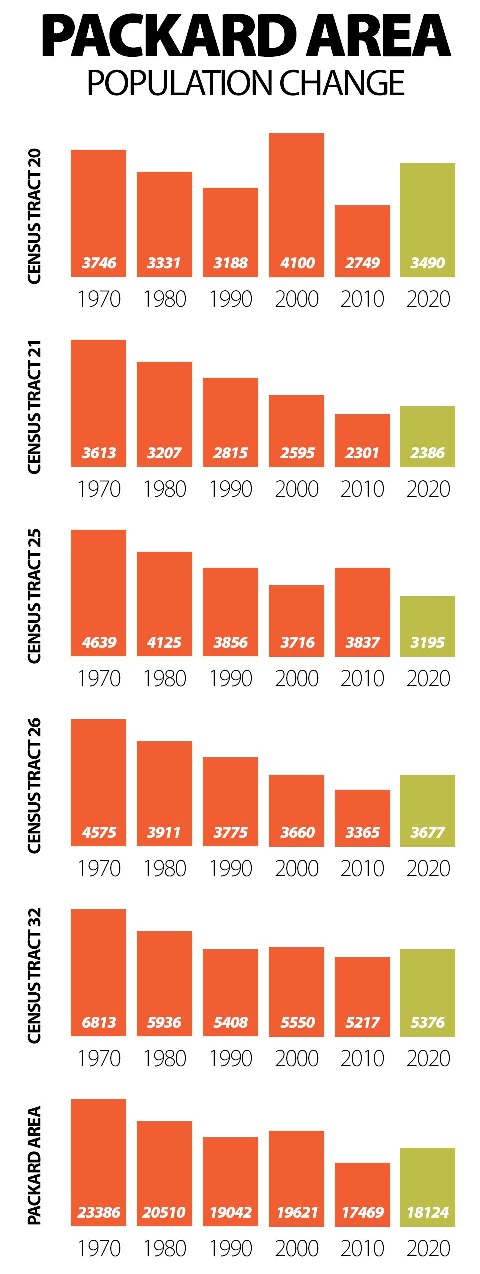
Population Change: The Packard Area has experienced slow, but regular growth over the past decade. The total population grew by +3.7%, or an increase of 644 new residents. The largest growth occurred in Census Tract 20, which experienced a nearly +25% increase, or 687 new residents. Overall, the Packard Area has seen a decline from its peak in 1970, but this is likely due to larger demographic shifts, including smaller families and outward migration. The 2020 Census shows that for the first time, the Packard Area has reversed the negative trend, and individuals are actively seeking to live in the nieghborhood.
Demographic Change: In 2020, the portion of the population selfidentified as “black only” was 14.6% of the total population of the area or 2,036 individuals.
In the past decade, the “black only” population declined by 22.0% The greatest growth occurred in the Hispanic/Latino population, with an increase of 826 from the total population of 2,324 in 2010.
In 2020 the Hispanic/Latino population was 19.6% of the area’s population or 3,150 individuals. The portion of the Packard Area population self-defined as “white only” declined by 13.8% over the last decade; this brought the total to 58.8% of the Packard area or 11,942 individuals. However, the actual number of “white only” people increased from 11,784 to 11,942, which was a slight increase of 158 individuals.
Packard 2030 22
Education Attainment: Education plays a crucial role in a neighborhood’s economic opportunity, and the Packard Area is seeing an overall increase in the number of adults with credentialed degrees. Overall, the Packard Area rose from 15.8% or 1,642 to 22.4% or 2,302 individuals with a bachelor’s degree. Notably however, the number of Adults aged 25+ without a high school degree or equivalent rose slightly from 13.2% or 1,372 to 13.6% or 1,397.

Workforce and Income: Overall, the Packard Area experienced slight household income growth over the past decade. When adjusted for inflation, the wages increased by +4.87% or $2,232. In Census Tract 21, the median household income increased +13.5% or $5,069. In Census Tract 20, however, the median household
Packard 2030 23
income decreased by -11.4% or $4,073. The Packard Area performs better than the city overall at Labor Force Participation, which is the proportion of the working-age population that is either actively working or looking for work.

Housing: The Packard Area, rich with historic homes and its proximity to downtown has been and remains a highly desirable area for renters. As elsewhere in the city, the Packard Area’s owneroccupied units has declined from 67.5% in 2010 to 59.8% in 2020, which is a 12.1% change. The most notable change is the number of units, which declined from 8,331 to 7,714, or a loss of 7.7%. This does not mean that 617 houses were removed, but approximately that number of units (individual residential units) were likely converted. With the Packard Area’s expected population growth of 4.6% by the year 2030, additional housing should be considered.

Poverty: The poverty rate in the Packard Area has increased in each decennial census, which is on-par with the Citywide average. In 2020, the poverty rate for the Packard Area was 16.1%, an increase of 10.3% since the year 2000, which is slightly less than the Citywide increase of 17.2%. The anomoly of the 2008 Economic Recession caused an sharp increase in Census Tract 21, and nearly doubled the poverty rate in Census Tract 25 from 2000 to 2010. While the two tracts closest to downtown have seen declines, the remainder have had an increase in poverty rates.

Packard 2030 24
NEIGHBORHOOD TRAFFIC
While several Packard Area streets see higher-than-average traffic volumes, the existing street grid provides ample circulation for neighborhood residents to ensure traffic is distributed throughout the area without significant congestion points. The primary corridors of Broadway, Paulding, Rudisill, and Fairfield continue to carry most vehicles. Broadway between Park and Wildwood in the Broad River and South Wayne neighborhoods is the busiest roadway segment with an AADT (Average Annual Daily Traffic) of 14,294. Broadway, connects Waynedale and several southwest neighborhoods to downtown, and overall is the busiest corridor. The eastern portion of Rudisill in the Packard Area is the second busiest segment of roadway, specifically between Fairfield and Calhoun, which connects many of the Packard Area residents to both the commercial areas of Rudisill and points south and east. Finally, Fairfield, a major north-south thoroughfare connecting residents and visitors between downtown and Fort Wayne International Airport, sees a steady traffic volume throughout much of the day. Most notable is the segment between Taylor and Poplar, Creighton to Downing, which borders the Hogland Masterson, Poplar, Williams-Woodland, and Creighton Home neighborhoods.
In the past few years, residents have increasingly requested to calm traffic in the Packard Area. Working with the city and the Active Transportation Coalition, residents have temporarily changed the intersection at Fairfield and Taylor, narrowing lanes on Fairfield at Kinsmoor. Participants of the traffic calming team also suggested changes to South Wayne, Broadway, Rudisill, and Harrison. The most successful intervention is the temporary closure of two one-way streets at Fairfield and Taylor, which has led to the elimination of the one-way pair entirely to reduce speeding on neighborhood streets and enforce limited access. This change made both Masterson and Williams safer for the residents of Hoagland Masterson (Irishtown).
Another growing area of concern is an increasing number of bicycle and pedestrian-related accidents and fatalities. This trend in the Packard Area is also seen nationwide. After reaching a low point in 2009, the nation has seen a 51 percent increase in pedestrian-related incidents. Pedestrian-related accidents account for approximately 17 percent of crash fatalities. Nearly two percent of people killed in motor vehicle crashes are bicyclists. Locally, in the Packard Area, there have been a number of pedestrian and cycle-related crashes. None of the crashes have been fatal, but road safety is still a concern for neighborhood residents. The most concerning high-traffic intersections are: Broadway and Creighton, Broadway and Bluffton, Creighton and Fox, Creighton and Fairfield, Fairfield and Taylor, Fairfield and Pontiac, Fairfield and Kinnaird, and Fairfield and Maxine. Packard Area residents should take measures to increase pedestrian safety to ensure residents can access daily needs within a 15-minute walk of their home without concern for dangerous traffic.
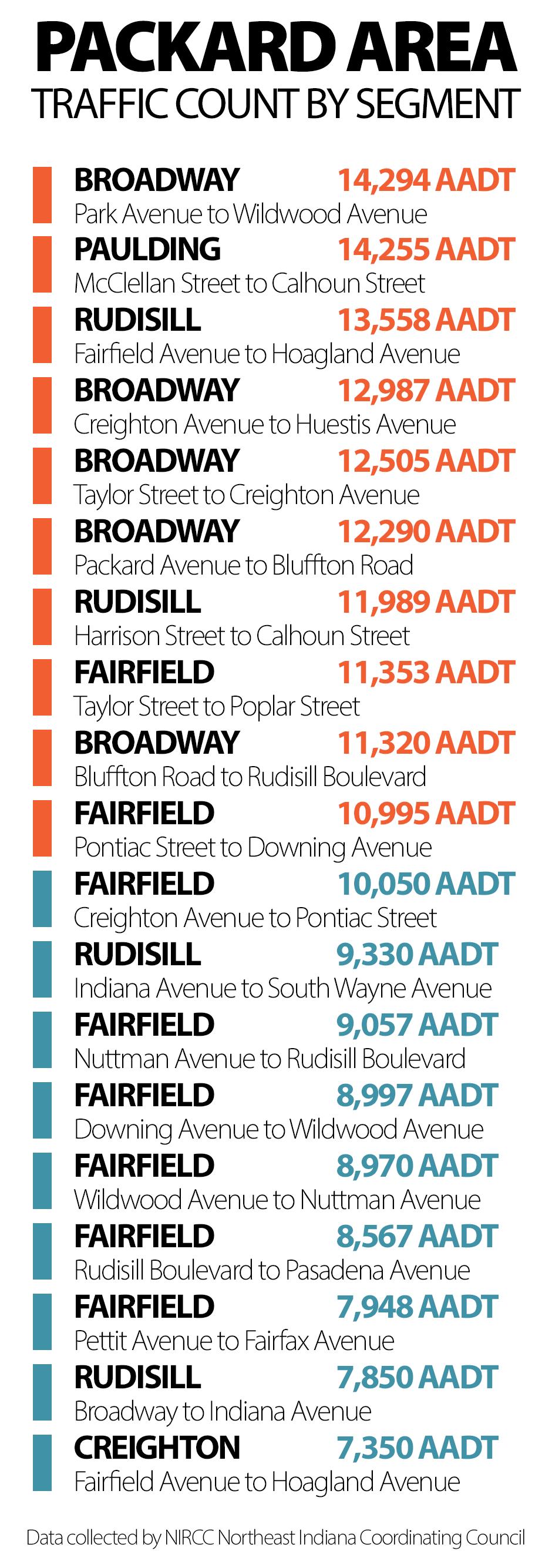
Packard 2030 25
Average Annual Daily Traffic
Map shows the highest traveled streets in the Packard Area


Packard 2030 26
NEIGHBORHOOD CRIME & SAFETY
Throughout the planning process, Packard Area residents expressed concern about increasing neighborhood crime. When asked which crimes were of most significant concern, residents overwhelmingly reported vandalism and burglary. While both of these crimes can significantly impact the perception of safety in the neighborhood, a third index, vice and narcotics can endanger the long-term psychology of the neighborhood. Vice and narcotics is defined as activities related to guns, illegal drugs, and gang activity.
Using police data from 2000, 2010, and 2019, we discovered that the perceived increase in crime was not reflected in the data. This finding does not discount the fear or financial/psychological impact that residents face as targets of crime. Instead, this data should be used as a tool to make incremental changes at the neighborhood level to increase a sense of safety and well-being. Most importantly, crime does not exist in a vacuum: neighborhoods with higher levels of criminal activity, specifically violent crimes, tend to suffer other problems associated with health, education, employment, housing, and the built environment. When considering this, the principles of CPTED (Crime Prevention Through Environmental Design) should be prioritized to improve the neighborhood’s built environment while addressing other issues much larger than the neighborhood itself.

VANDALISM
Criminal acts of vandalism can occur in many forms such as defacing private or public property, breaking doors and windows, keying cars, and spray painting property. In 2000, criminal acts of vandalism accounted for 15.35% of all criminal activity in the Packard Area and have dropped to just 7.35% of all criminal acts today. This is a positive trend for the Packard Area thanks to greater resident and business investment and improved association organization, and should be celebrated.
A notable decline in vandalism occurred in Broad River, which saw the criminal acts decrease by nearly two-thirds from 27 in 2000 to just 9 in 2022. Other neighborhoods that saw significant decreases include Poplar which decreased from 43 in 2000 to 12 in 2022 and Hoagland Masterson which fell from 38 in 2000 to 16 in 2022 Fairfield fell from 33 in 2000 to 18 in 2022, and Oakdale also saw a significant decrease from 25 in 2000 to just 4 in 2022
Fort Wayne Police Department
Packard 2030 27
John Felts, City of Fort Wayne
BURGLARY
When a criminal act of burglary is committed, it can make a resident or business owner feel less safe. As the Packard Area seeks to maintain and enhance the quality of life for each member of the neighborhoods, steps to improve home and property safety are extremely valuable. Improvements often proposed by safety organizations include target-hardening and access-control strategies such as locks, gates, fencing and lighting. The most critical interventions are block parties and neighborhood gatherings, which bring neighbors together and encourage them to look out for one another. 14.2% of all criminal activity in the neighborhoods was a burglary or related activity in 2010, but even this type of crime has seen a sharp decrease to just 5.7% in 2022. This, too, is another positive trend for the Packard Area as neighborhoods are making important strides in improving safety and security for residents and businesses.
Significant decreases in the criminal act of burglary were found in Broad River, which dropped from 48 in 2000 to 12 in 2022, and the Creighton Home neighborhood, which decreased from 51 in 2000 to just 8 in 2022. Fairfield decreased from 26 incidents in 2000 to just 9 in 2022, and Fairmont saw a decrease from 14 acts in 2000 to just 3 in 2022. Two stand-out neighborhoods, including Southwood Park and Williams Woodland, have seen a substantial decrease, which should be considered for further study on best practices.

VICE & NARCOTICS
When neighborhoods experience criminal activity related to vice and narcotics, defined as illegal guns, drugs, and gang activity, it can have a psychological impact on nearby neighbors. In stakeholder interviews and other engagement activity, the fear of drugs and gangs was closely associated with the perception of rising criminal activity. However, police department data shows this type of crime has decreased. The Packard Area saw a decrease of over 80% from 71 incidents total in 2000 to just 14 in 2022. While vice and narcotics tend to be larger than the neighborhood itself, neighborhood/area programs have been shown to help. These programs aim to provide access and control, improve responses to residents’ service and maintenance needs, enhance neighborhood stability, and educate about drug prevention and intervention
Hoagland Masterson should be seen as a huge success for the Packard Area, with a significant decrease from 31 incidents in 2000 to just 1 in 2022. A similar story can be shared about Poplar, which has dropped from 17 incidents in 2000 to just 2 incidents in 2022
CONCLUSION
Overall, crime in the Packard Area has been steadily declining, with the total number of incidents in 2000 being 2,129 dropping 19.5% to 1,751 in 2022. Even when overall crime reached a peak in 2013, crime has continued to decline year over year, decreasing nearly 25% from the its most recent high.
While serious crime continues to decline, personal crimes related to domestic disturbance, battery and assault, and are starting to rise. Another area of concern is the increase in suicidal threats and attempts, which has increased nearly 400%. These crimes should continue to be monitored for future intervention where possible.
Packard 2030 28
* Graph above shows TOTAL MAJOR INCIDENTS rather than total incidents
Packard Area Crime Heat Map

Map represents total calls for major incidents (2000, 2010, 2022)
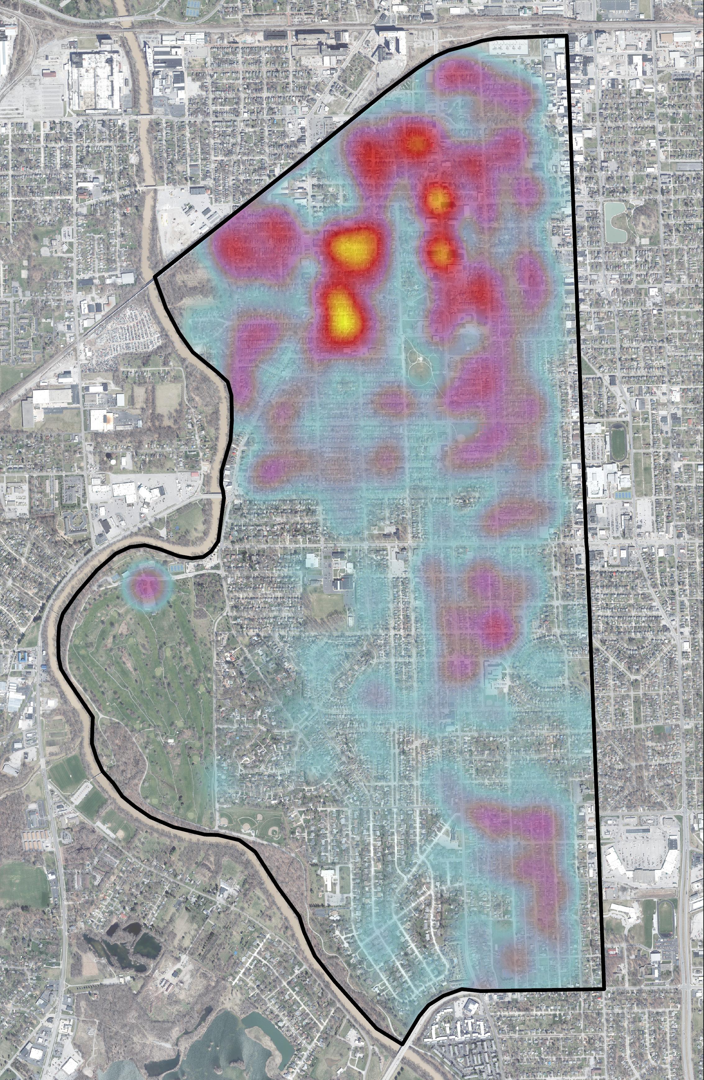
Packard 2030 29
LAND USE & ZONING
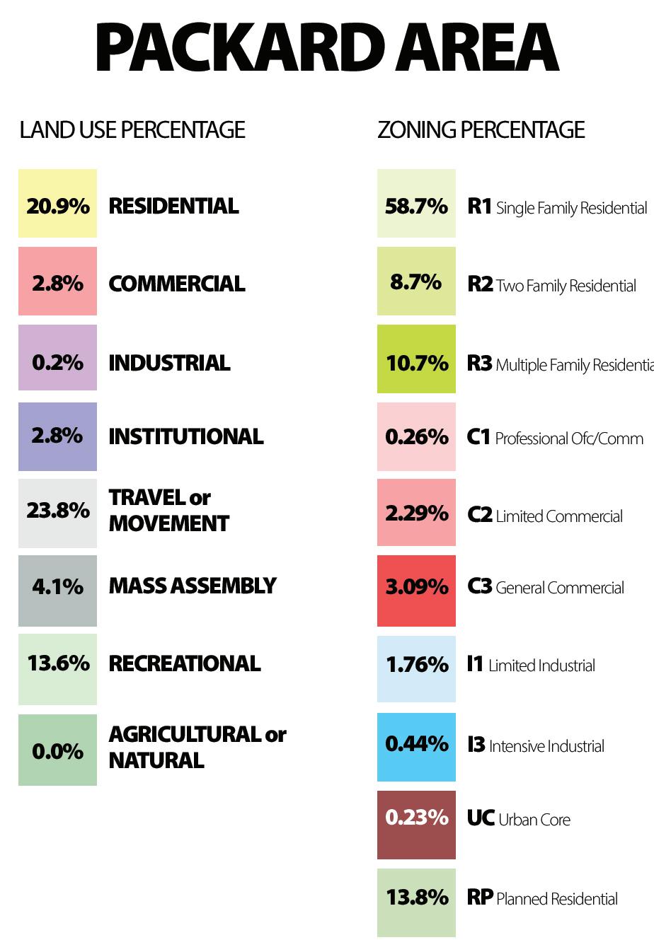
The Packard Area features a variety of land uses but is and has predominantly been a cluster of residential neighborhoods. The majority of homes are R1 (Single Family), especially those on the southern half of the defined area. As with much of Fort Wayne, commercial use remains closely tied to the north-south corridors leading into and out of downtown, while primary east-west corridors such as Creighton, Rudisill, Pettit, and Paulding remain residential with few exceptions. In the past few years, a new zoning classification was applied on a small segment of Fairfield Avenue near Lutheran and Packard Parks called Urban Corridors (UC). Urban Corridors encourage traditional urban form with mixed-use buildings close to the street which promotes walkability. Finally, approximately two percent of the Packard Area is zoned Industrial Limited (I1) and Industrial Intensive (I3) I1 and I3. The industrial zones are primarily close to downtown in the Poplar and Hoagland Masterson neighborhoods, where industry has existed for over a century.
 Commercial Shops at Irishtown
Packard 2030 30
Josh Campbell, City of Fort Wayne
Map shows the different land uses

Area Land Use
Packard
Packard 2030 31
Map shows the various zoning classes used

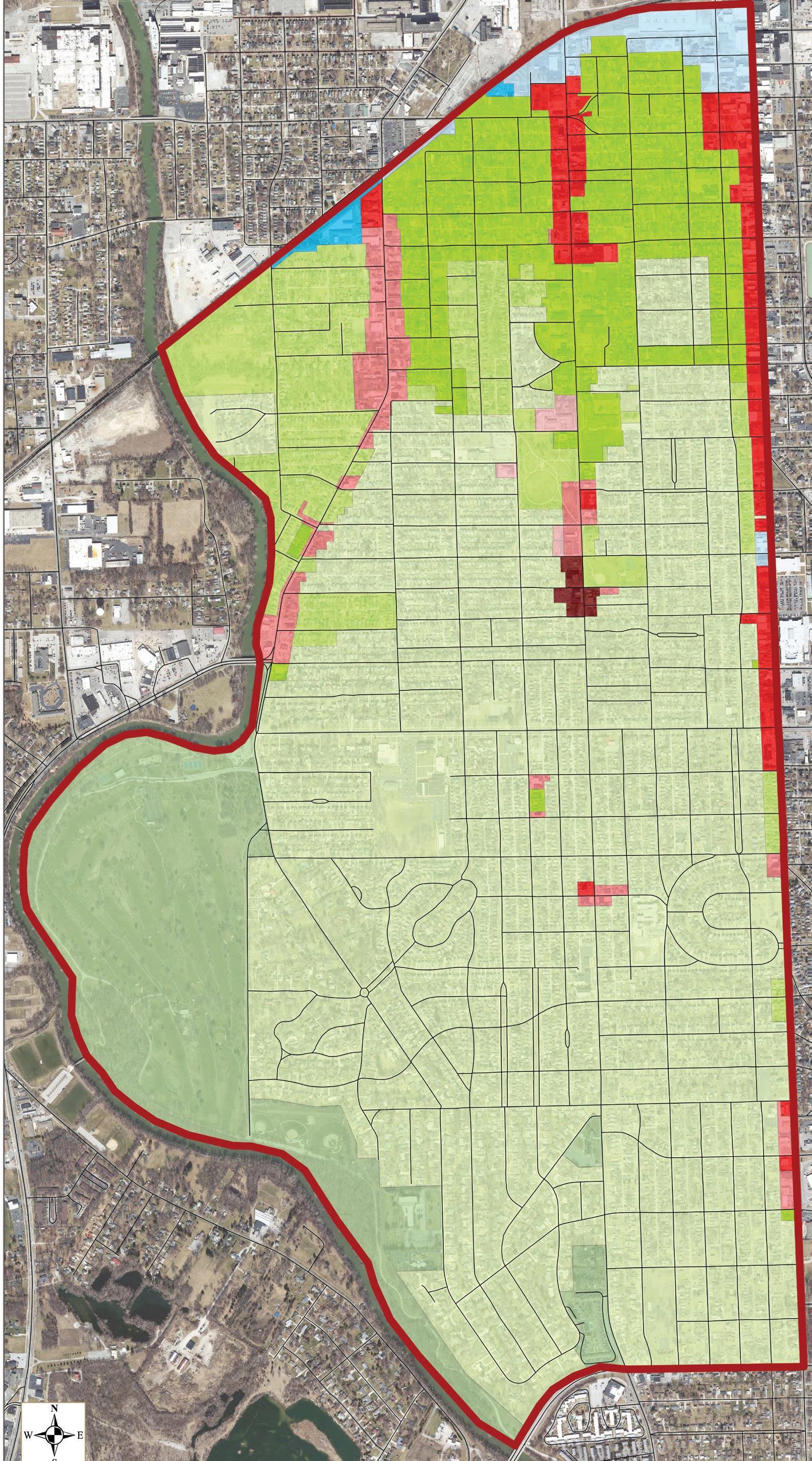
Area Zoning
Packard
Packard 2030 32
ECONOMIC OUTLOOK
STI (Synergos Technologies Inc.) Spending Patterns:
Understanding how the average Packard Area resident spends their weekly income and how much they are willing to pay for a specific product or service helps organizations better understand the neighborhood economic profile. This data is sourced from STI (Synergos Technologies Inc.) and measures spending pattern data, provided through the BLS (Bureau of Labor Statistics).

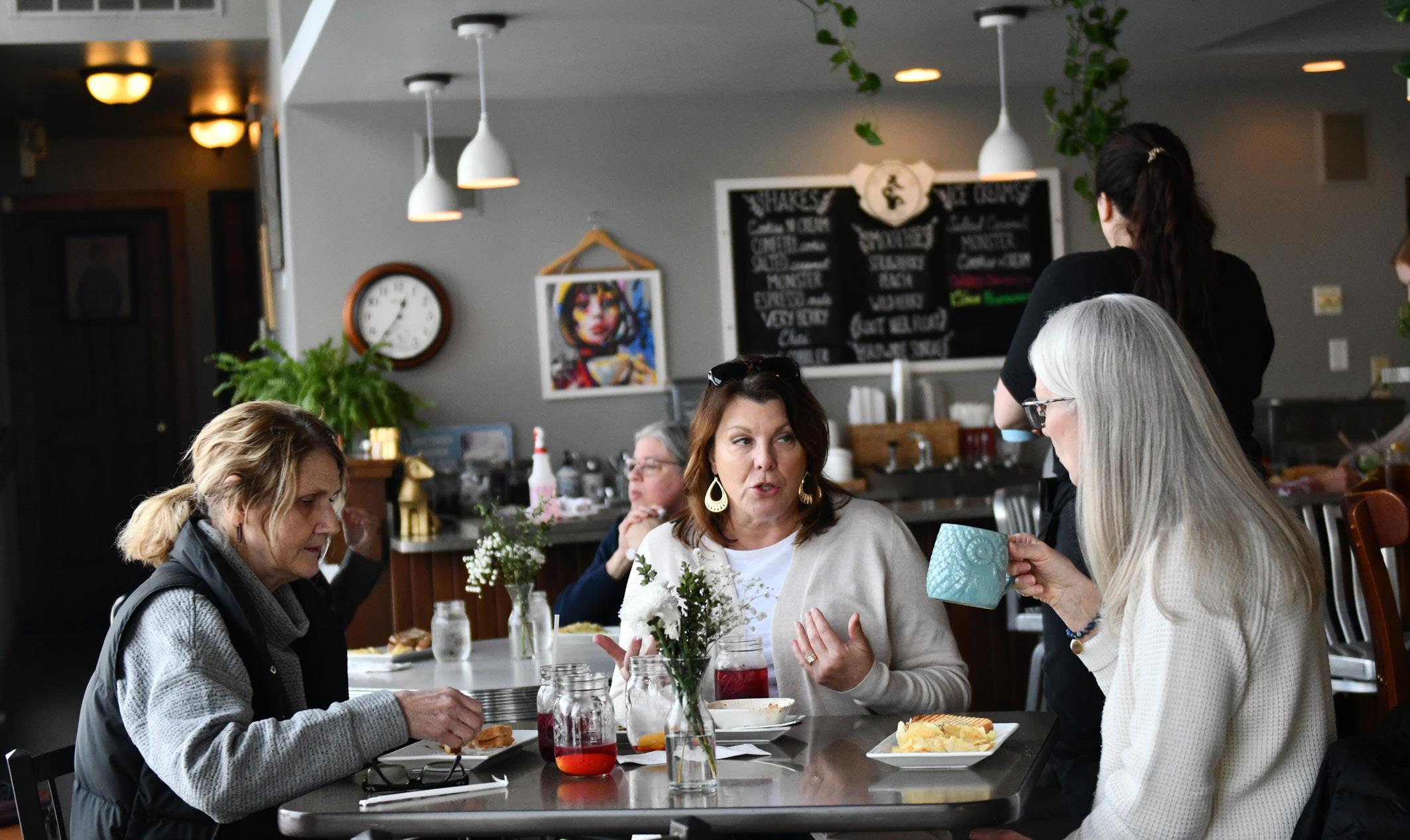
In the Packard Area, the average weekly spending per person is $339, of which 25% immediately supports housing costs and an almost equal amount to transportation costs. Understanding this weekly expense is crucial because nearly 50% of a resident’s weekly expenses go to hard costs that are inflexible. After all, reliable shelter and transportation are critical expenses. This leaves fewer dollars for other necessities like food, healthcare, and personal care.
STI (Synergos Technologies Inc.) Market Outlook:
Estimated figures for the Packard Area help us understand the supply and demand insight needed to meet the real consumer demands of residents. This data shows us that while the average annual demand for goods and services of residents in the Packard Area is $278.4 Million, there is not enough supply of goods and services at $183.6 Million to make the Packard Area a self supportive neighborhood ecosystem. This means approximately $94.8 Million leaves the Packard Area for goods that cannot be found in the geographic area, such as groceries, clothing, and health/ personal care goods. This data uses STI (Synergos Technologies Inc.) Market Outlook data to directly compare the annual retail sales and consumer spending in each retail segment identified by the NAICS (North American Industry Classification System) and provide supply/demand insight for the neighborhood(s).
Lunch with friends at Friendly Fox
Packard 2030 33
John Felts, City of Fort Wayne
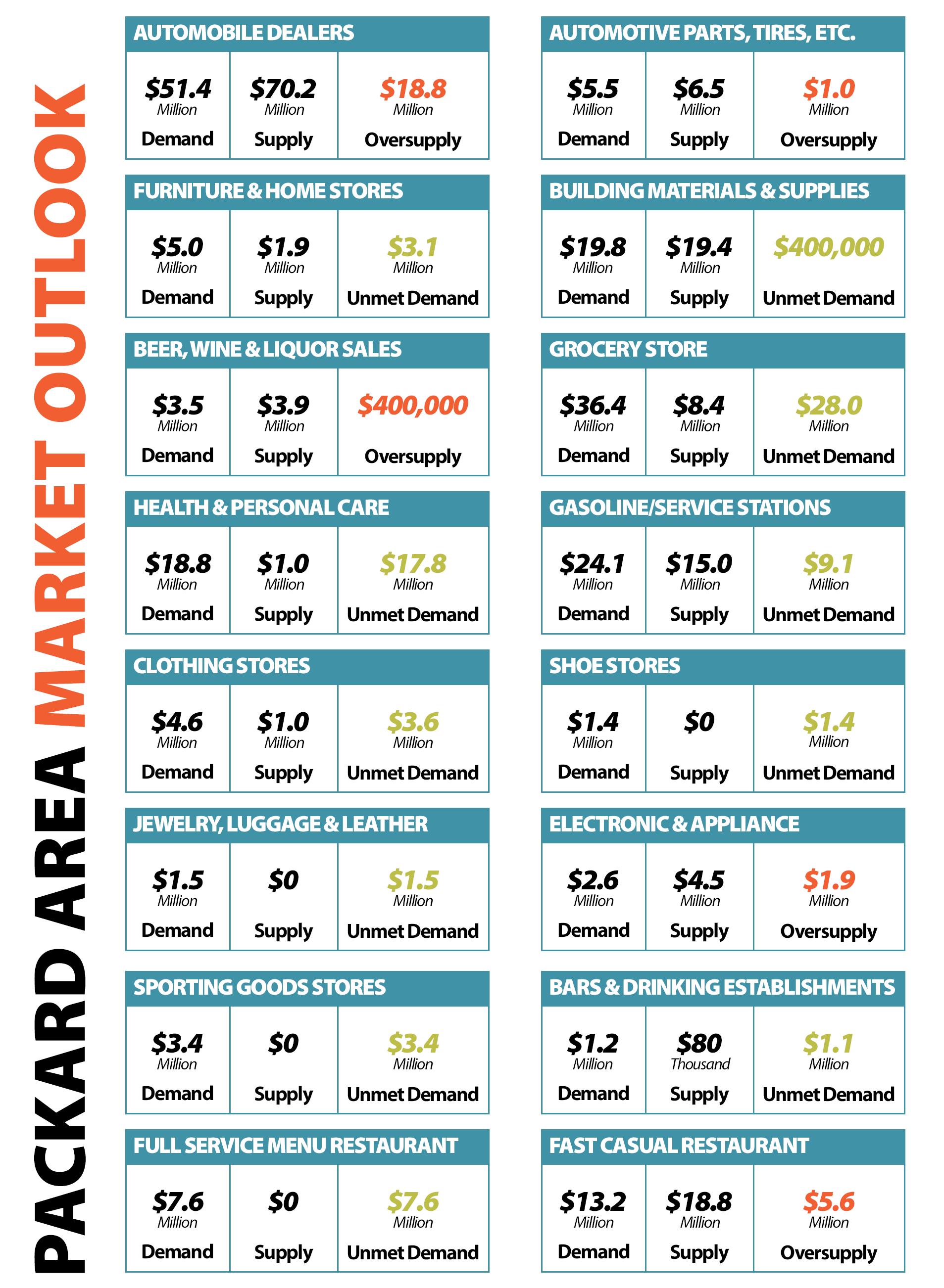
Packard 2030 34
Antonuccio’s Italian Market Fresh Food
John Felts, City of Fort Wayne
Resident Journey
Using new sophisticated technology, we can capture the flow of activity to and from properties for both residents and visitors of the Packard Area. The data provided is an estimate based on the data available. The trip data is measured between April 1, 2017, and March 31, 2022.
Several residents in the Packard Area responded to the survey that they would like to see additional food resources provided in the neighborhood via a new grocery store. As evidenced by neighborhood residents’ flow of activity, the top destinations continue to be Walmart Supercenter, Kroger, and Meijer, confirming that most residents travel by personal vehicle for grocery or general merchandise shopping more so than any other destination. Additionally, residents regularly traveled to local educational facilities such as Southside High School, Wayne High School, and Bishop Luers High School, and public space amenities such as Foster Park, Packard Park, and Parkview Field, which shows the importance of ensuring our access to both educational and recreational facilities. It is important that we continue investing in transportation access to residents in the Packard Area to the areas they travel to the most.

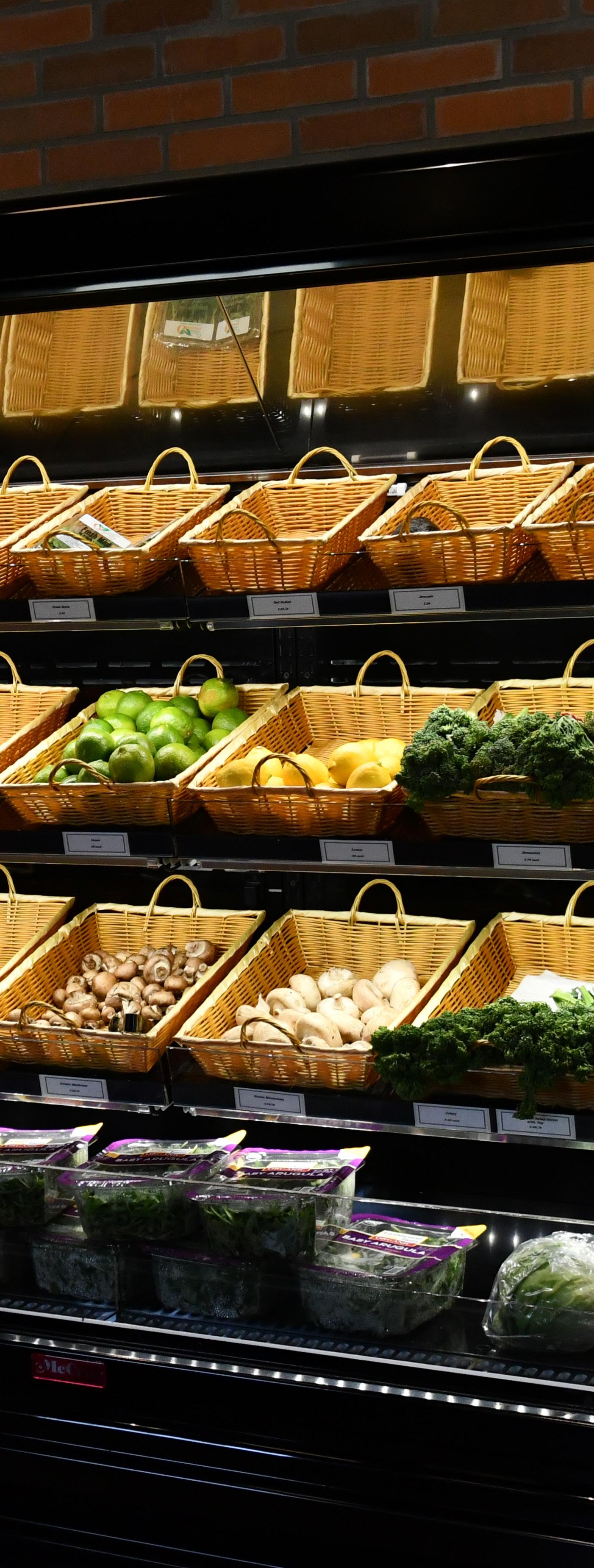
Packard 2030 35
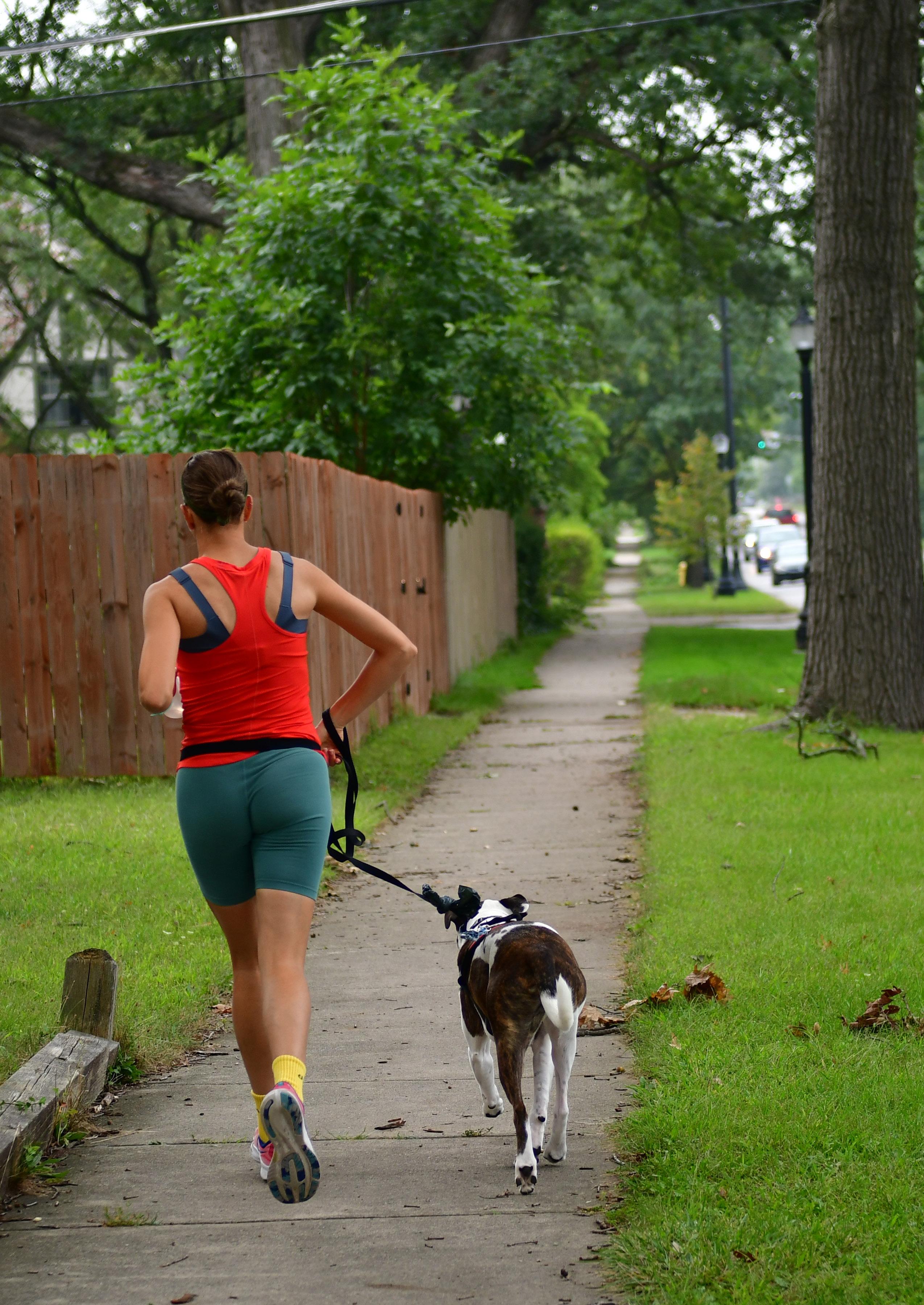
Packard 2030 36
PACKARD 2030 RECOMMENDATIONS
”
Designing a dream city is easy; rebuilding a living one takes imagination.
Jane Jacobs
Packard 2030 37
The Packard 2030 Steering Committee considered an exhaustive list of Guiding Principles, Neighborhood Priorities, and Potential Implementation Strategies to inform future policies that will impact the Packard Area for the next generation. These recommendations are intended to establish broad goals and parameters to guide future efforts to advance the Packard Area. Specific regulations and policies that will be used to address future issues may differ from those listed in the following section. For that reason, it should be noted that the following goals, strategies, and actions are not definitive but rather provide guidance to the Packard Area and its 18 neighborhood(s).
With the complexity of issues and diverse views presented throughout the engagement process, it is important to note that not all of the listed recommendations represent the position of every steering committee member. However, the Packard 2030 Steering Committee members have concluded that based on the input provided by nearly 1,500 residents, businesses, and stakeholders, the following recommendations are well balanced and will advance the overall goals of the Packard Area. In the coming decade, if a new project or program commences and is not consistent with the priorities listed, it should only be done with consultation and feedback from the public.
Spring on South Wayne
Josh Campbell, City of Fort Wayne
While some of the recommendations call out specific neighborhood area priorities, the implementation strategies listed on the following pages should be considered by the Packard Area as each neighborhood has multiple tangible interconnections that support a healthy, vibrant and prosperous community for all.
Finally, it should be noted that the recommendations are presented in the context of the greater planning effort for the Packard Area. Packard 2030 summarizes the recommendations that emerged from the engagement process and reflects the highest priorities that should guide future implementation. The document is designed to be ‘living,’ which means that the broad recommendations can be adjusted to meet future needs without dismissing thousands of voices and hours of work.
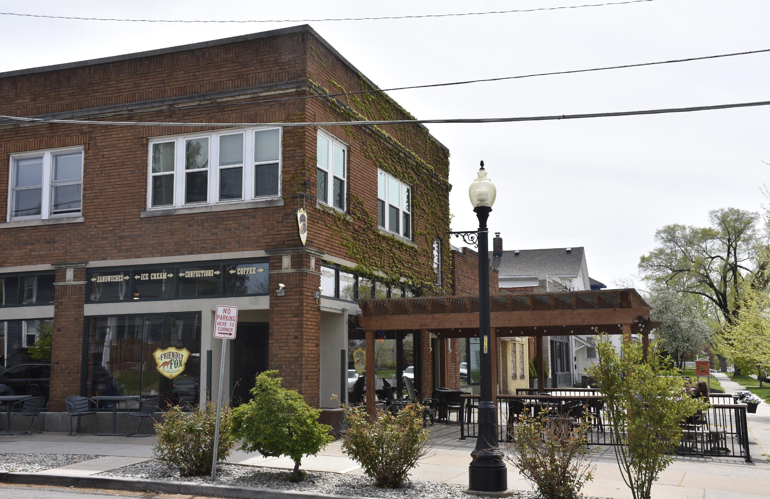
Packard 2030 38
NEIGHBORHOOD REVITALIZATION
At the heart of the mission for the Packard Area Planning Alliance is the notion that every resident should have the ability to thrive in their neighborhood. Engagement responses throughout the planning process emphasized that while the Packard Area has seen significant positive growth over the past decade, a renewed focus on neighborhood revitalization was paramount. To achieve these results, there are five primary goals:
• (1) Providing Safe, Diverse, and Quality Housing Choices that ensure one’s residence is a place where one can live their best life,
• (2) Supporting Neighborhood Businesses which serve the population by providing goods and services,
• (3) Enhancing Neighborhood Corridors as they are the seams that bind the primarily residential neighborhoods together,
• (4) Applying Appropriate Zoning so that property can reach its best and highest use, and
• (5) Neighborhood Health and Safety which considers how the built environment can impact one’s sense of security and wellbeing.
Sustainability: Using the lens of sustainability, we encourage all revitalization efforts to be done with both interior and exterior environmental concerns in mind, in order to ensure the well-being of residents both at home and in their community. Therefore, this plan encourages ecologically sound improvements to housing stock (i.e. using renewable energy sources, non-toxic materials, and high energy-efficiency appliances, systems, and fixtures), commercial building stock (that can be repurposed or adaptively reused), and public infrastructure.
Equity: Using the lens of equity, this focus area details how we seek to retain residents and supportive businesses of diverse races, ethnicities, and income levels. We recognize that the way to achieve this goal is to encourage a variety of mixed-income housing, along with commercial and retail opportunities so residents who want to remain in the Packard Area have the ability to do so. Additionally, the Neighborhood Revitalization goals promote neighborhood accessibility and welcomeness by stipulating the resources and marketing should be provided for and made with the intention of engaging neighbors of various languages and abilities.
Packard 2030 39
housing
At the core of neighborhood revitalization is the concept of safe, diverse, and quality housing that all can access. The Packard Area provides a dense tapestry of nearly 8,000 units across various housing types. The Median Value of owner-occupied units in the Packard Area is $79,120 (2020), which is 65% of the average for the entire Fort Wayne community. This remains consistent with values of property in the year 2000 as the Median Value of owneroccupied units was roughly $80,022 after being adjusted for inflation to reflect the value of the dollar in 2020.

Housing Potential
The 2021 Residential Market Potential Study completed by Zimmerman & Volk found that each year, over the next five years (2022-2027), an annual average of 3,315 households of all incomes have the potential to move within or to the study area. The housing preferences were (1) Rentals at 46.8%, (2) Detached Houses at 39.7%. The household types which are most likely to move within the study area are (1) Young Singles & Childless Couples at 42.7%, (2) Traditional and Non-Traditional Families at 36.5%, and (3) Empty Nesters and Retirees at 20.8%.

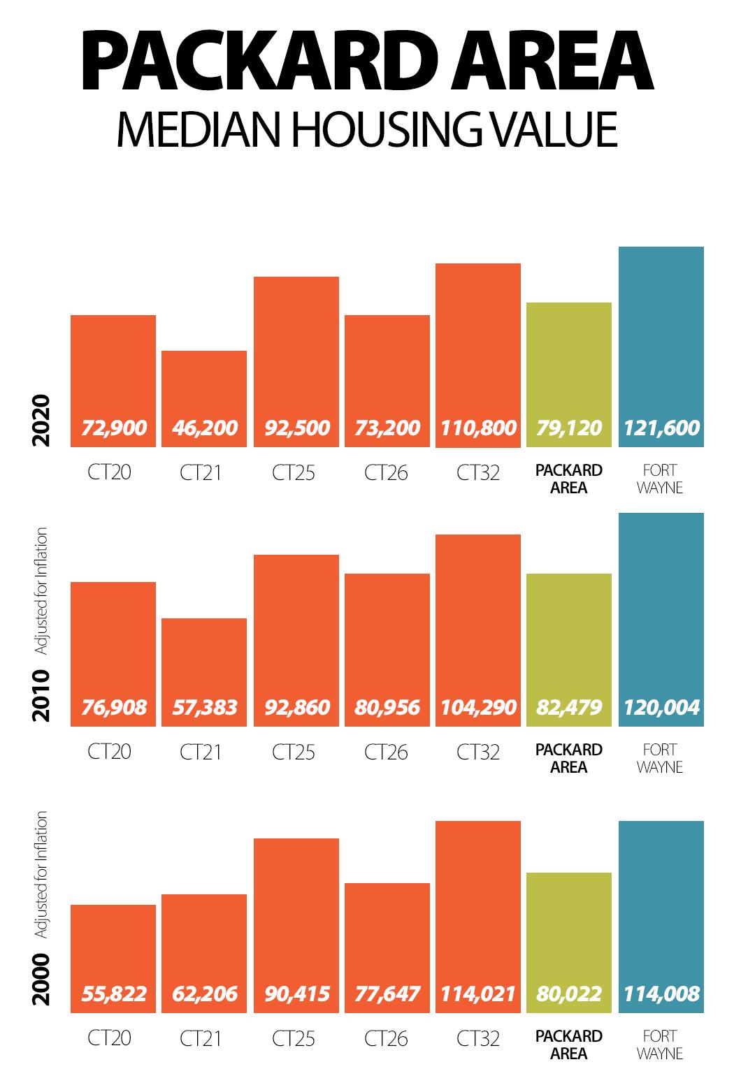
Housing choice is greatly influenced by income as is housing affordability which is determined by how much a household pays in monthly or annual housing costs. As the city’s population grows and demand for new housing follows, housing costs will continue to increase in many neighborhoods, including Packard, unless the number and types of housing units increase. With its proximity to Downtown Fort Wayne, the new Electric Works campus, and the availability of vacant lots, the Packard Area is uniquely poised to add new infill housing stock in the next decade, making it an even more attractive neighborhood for all.
The Average Annual Market Potential for New and Existing Housing Units is used to understand the potential for the 3,315 households that would consider relocating in the study area.
Packard 2030 40
Each of the household types, or target groups, are further considered to understand better the types of housing and lifestyle needs that should be met.
Blue Collar Retirees
• Primarily singles, some married couples
• Average Household Size - 1 Person
• Predominant Age Range - 55 to 74
• Preferred Housing Characteristic - Detached Houses and Townhomes
Hometown Seniors
• Primarily singles, widows and widowers, and couples
• Average Household Size - 1 to 2 Persons
• Predominant Age Range - 65 and Older
• Preferred Housing Characteristic - Small Detached Houses and Townhomes
In-Town Families
• Primarily couples with infants and school-age children (growing multi-generational families)
• Average Household Size - 2 to 4 Persons
• Predominant Age Range - 35 to 54
• Preferred Housing Characteristic - Affordable Detached Houses

New American Strivers
• Primarily Older Married Couples with Children
• Average Household Size - 2 to 4 Persons
• Predominant Age Range - 35 to 54
• Preferred Housing Characteristic - Affordable Detached Houses in Ethnic/Cultural Areas
Small City Singles
• Primarily Singles, but some newly married couples
• Average Household Size - 1 to 2 Persons
• Predominant Age Range - 25 to 54
• Preferred Housing Characteristic - Detached and Attached Houses in Ethnic/Cultural Areas
Suburban Achievers
• One-Third are Married Couples, One-Third are Single Person Households
• Average Household Size - 1 to 3 Persons
• Predominant Age Range - 30 to 44
• Preferred Housing Characteristic - Apartments and Townhomes
Of those 3,315 households, 1,998 would have incomes at or above 60 percent AMI (Area Median Income), which would cover the required income to rent or purchase workforce/affordable homes and market-rate housing units. The housing preferences of these 1,998 households are (1) Rentals at 848 units per year, or 42.4%, and (2) Detached Houses at 845 units per year or 42.2%. If new development could achieve the rates as outlined, the study area could absorb between 122 and 166 new units per year or a total
of 610 to 830 new rental and for-sale workforce/affordable and market-rate units over the next five years.
As outlined above, any new development in the Packard Area could absorb 86 to 118 new Market Rate Units per year, with a majority (nearly 60% to 70%) being Rental Units. The median household income of the Packard Area is $53,745, which is 96% of the median for the entire Fort Wayne community. This means that to ensure housing remains affordable and residents are not ‘burdened,’ the annual cost of housing should remain below $16,000 or approximately 30% of the median household income.
GOAL ONE:
All Neighborhoods Within the Packard Area Should Provide Safe, Stable, Fair, Diverse, and Quality Housing
Choices
1.1 Encourage regular maintenance and upkeep of residential properties in a way that supports the existing character of the neighborhood(s)
• 1.1.1 Work with non-profit housing organizations to create a centralized hub of educational materials that provide information for homeowners on a variety of housing maintenance and upkeep topics
• 1.1.2 Work with neighborhood leaders to develop homeowner and landlord maintenance and rehabilitation education programs
Packard 2030 41
1.2 Support income-eligible residents with assistance that provides regular maintenance and upkeep of residential properties
• 1.2.1 Promote government-funded home repair programs that assist income-eligible residents
• 1.2.2 Develop a Volunteer Packard Day event and harness neighborhood capacity and local labor to help seniors and residents with disabilities complete minor home repairs
• 1.2.3 Create a database of neighborhood residents with the skills and abilities to assist residents in need
1.3 Support the development and rehabilitation of housing that can be acquired by both renters and homeowners at affordable rates
• 1.3.1 Establish a new Packard Area Planning Alliance subcommittee focused on building relationships with realtors, homeowners and landlords to implement goals related to housing
• 1.3.2 Prioritize the disposal of City-owned Blight Elimination Properties for the development of missing-middle housing that can assist in making homeownership affordable
• 1.3.3 As existing housing becomes available, work with housing-based non-profit organizations to rehabilitate units
that can be acquired at affordable rates
• 1.3.4 Educate residents of the Packard Area on the importance of providing affordable housing for both tenants and homeowners in neighborhoods

• 1.3.5 Encourage and support the development of new attached single-family, duplex, and multi-family properties that match the density and/or improve the existing design character of the neighborhood(s) properties
1.4 Encourage developers to build a variety of housing options through infill development projects
• 1.4.1 Work with the City’s Community Development Division to identify available properties that can be prioritized for infill housing development
• 1.4.2 Share relevant housing and demographic data to support housing development efforts
• 1.4.3 Work with realtors to create marketing materials that promote available properties in the Packard Area available for infill to developers
• 1.4.4 Encourage developers and homeowners to use environmentally responsible construction techniques and renewable energy in new and rehabilitated housing development.
Residential on Williams Street
Packard 2030 42
John Felts, City of Fort Wayne
1.5 Support the expansion of homeownership programs
• 1.5.1 Encourage Fort Wayne companies to purchase homes in the Packard Area that can be used to relocate new residents to the city
• 1.5.2 Work with realtors to create marketing materials that promote homeownership and attract new residents to the Packard Area
• 1.5.3 Identify current homeowners in the neighborhoods to champion the benefits of the Packard Area that can be used in marketing and outreach campaigns
• 1.5.4 Educate homeowners about predatory investors to encourage long-term investments that support the continuous improvement of the neighborhood
1.6 Support the development of tenant-based programs
• 1.6.1 Establish a new Packard Area Planning Alliance subcommittee that works to encourage relationship building between tenants and neighborhood associations.
• 1.6.2 Encourage neighborhood associations to invite tenants to meetings and become active participants in organizations, programs and projects
• 1.6.3 Work with organizations to provide educational materials for both tenants and landlords about rights, responsibilities, and opportunities in the Packard Area
business
Packard 2030 supports neighborhood businesses and aspiring entrepreneurs to launch and grow their businesses in the Packard Area. In addition to providing jobs and services, small neighborhood businesses can help foster an active and vibrant street life and create a reason for people to visit the neighborhood(s). The Packard Area has a few unique business areas, especially along Broadway and Fairfield Avenue. Still, many of these businesses have had their earnings potential stunted by unattractive facades, poor neighborhood connectivity, lack of proper nearby density, and the growing affordability gap.
While newer businesses have quickly set the tone for the economic development trajectory of the neighborhood, according to the STI: Market Outlook, the Packard Area still has nearly $95 Million in unmet demand, meaning that Packard Area residents are spending significant amounts of their income outside of the neighborhood(s). This means that the Packard Area still has significant room for additional neighborhood businesses that can meet residents’ demands, support the local community, and fill vacant storefronts on key corridors.
GOAL TWO: Support Neighborhood-Oriented Businesses And Entrepreneurship Programs
2.1 Support existing neighborhood businesses and expand access to quality retail
• 2.1.1 Establish a new Packard Area Planning Alliance subcommittee focused on supporting neighborhood-based businesses
• 2.1.2 Produce a working list of existing Packard Area commercial establishments that is updated on an annual basis
• 2.1.3 Utilize the Packard Area website, as well as neighborhood newsletters and social media pages to promote and spotlight Packard Area commercial establishments
• 2.1.4 Encourage Packard Area commercial establishments to offer promotional incentives to attract neighborhood residents to support local business
2.2 Make the Packard Area a destination for entrepreneurs and start-up businesses
• 2.2.1 Promote existing initiatives that support neighborhoodbased entrepreneurship
• 2.2.2 Explore the development of a neighborhood-level incubator space that offers below-market-rate or incomebased rents for new entrepreneurs who are based in the Packard Area
• 2.2.3 Create a market study that highlights the economic sectors that would be supported by neighborhood residents in order to assist neighborhood-based entrepreneurs and small businesses
• 2.2.4 Partner with a financial institution that provides guidance for entrepreneurs who are seeking assistance on financing property and associated improvements in the Packard Area
2.3 Support business development opportunities for marginalized populations
• 2.3.1 Encourage neighborhood businesses to employ neighborhood residents
• 2.3.2 Develop a multilingual marketing strategy that promotes neighborhood businesses to residents of the Packard Area
• 2.3.3 Develop marketing tools that assist minority business owners with business resources and facade improvements
• 2.3.4 Coordinate minority owned businesses and entrepreneurs with existing organizations to promote business development and access to support and capital
Packard 2030 43
corridors
Streets and sidewalks connecting residents and visitors in the Packard Area to destinations such as downtown, Foster Park, Electric Works, Fort Wayne International Airport, and Southside High School are connections and transportation routes that people frequent the most. The main corridors in the neighborhood, such as Broadway, Fairfield, Creighton, Rudisill, and Calhoun, often feel disconnected or too busy to add value to the neighborhood. Broadway, the busiest stretch of roadway in the Packard Area, connects thousands of residents to downtown Fort Wayne but can feel overwhelming to pedestrians walking to their destinations. During the planning process, residents and businesses alike noted that corridor improvement strategies, such as beautification, safe and even sidewalks, facade improvements, public space amenities, and the new infill to add to the density, are essential.
The City has invested in completing beautification and safety upgrades with pedestrian-level decorative lights along Fairfield Avenue and Broadway in recent years. Future investments along the Fairfield Avenue corridor include new streetscape improvements at Taylor and Fairfield and additional pedestrian level lighting investments on Fairfield south of Rudisill. These initiatives will continue to invigorate the corridors by creating a sense of place and safety that promote community connection and interaction.
• 3.1.5 Enhance the existing sidewalks and streetscape on Broadway Avenue between the Norfolk and Southern Railroad Line and Park Avenue to promote pedestrian activity and improve the aesthetics of the nearby commercial area
3.2 Improve corridor aesthetics through Facade Improvements
• 3.2.1 Encourage facade improvements in the ‘Irishtown’ commercial area between Locust Street and Creighton Avenue
• 3.2.2 Encourage facade improvements in the Packard Park commercial and recreational areas between Kinnaird Avenue and Nuttman Avenue
• 3.2.3 Encourage facade improvements on Broadway Avenue between the Norfolk and Southern Railroad Line and Park Avenue
• 3.2.4 Translate marketing and outreach materials promoting facade improvement programs in both Spanish and Burmese, and promote in multiple area publications
3.3 Prioritize beautification efforts on corridors
• 3.3.1 Prioritize a beautification strategy that enhances the visual appearance of the Broadway Corridor between Park Avenue and Rudisill with additional street trees, banners, signage and floral/plant displays encouraging pedestrian connectivity to Foster Park
THREE: Enhance Neighborhood Commercial Corridors To Improve Neighborhood Identity And Support Neighborhood Businesses
GOAL
3.1 Improve commercial corridors through streetscape enhancements
• 3.1.1 Develop a corridor enhancement plan for the Broadway and Fairfield corridors in the Packard Area
• 3.1.2 Enhance the existing sidewalks and streetscape on Fairfield Avenue between Locust Street and Creighton Avenue to promote pedestrian activity and improve the aesthetics of the nearby ‘Irishtown’ and commercial area
• 3.1.3 Enhance the existing sidewalks and streetscape on Fairfield Avenue between Creighton Avenue and Pontiac Street to promote pedestrian activity and improve the aesthetics of the nearby Beechwood Historic District, commercial and institutional areas
• 3.1.4 Enhance the existing sidewalks and streetscape on Fairfield Avenue between Kinnaird Avenue and Nuttman Avenue to promote pedestrian activity and improve the aesthetics of the nearby Packard Park, commercial and recreational areas
• 3.3.2 Prioritize a beautification strategy that enhances the visual appearance of the Fairfield Corridor between Home and Rudisill with additional street trees, banners, signage, and floral/plant displays encouraging pedestrian connectivity to Packard Park
• 3.3.3 Prioritize a beautification strategy that enhances the visual appearance of the Fairfield Corridor between Pettit and Paulding/Airport Expressway with additional street trees, banners, signage, and floral/plant displays encouraging pedestrian connectivity to Kettler Park
• 3.3.4 Prioritize a beautification strategy that enhances the visual appearance of the Rudisill Boulevard gateway between Calhoun and Fairfield with additional street trees, banners, signage, and floral/plant displays that follow recommendations in the mixed-use cultural Landscape report.
• 3.3.5 Support additional beautification efforts in neighborhoods, especially near playgrounds, open spaces, and boulevards.
A new brand identity was designed for Irishtown, reflecting stories and feedback from nearly onehundred residents, businesses and organizations in the Hoagland Masterson and Poplar Neighborhoods. The brand will be incorporated incrementally through investments, marketing and outreach.

Packard 2030 44
irishtown
Reinforce the vibrant mixed commercial character of Irishtown through contextually sensitive redevelopment with public realm improvements and neighborhood services while promoting additional housing opportunities and protecting existing neighborhood residents.
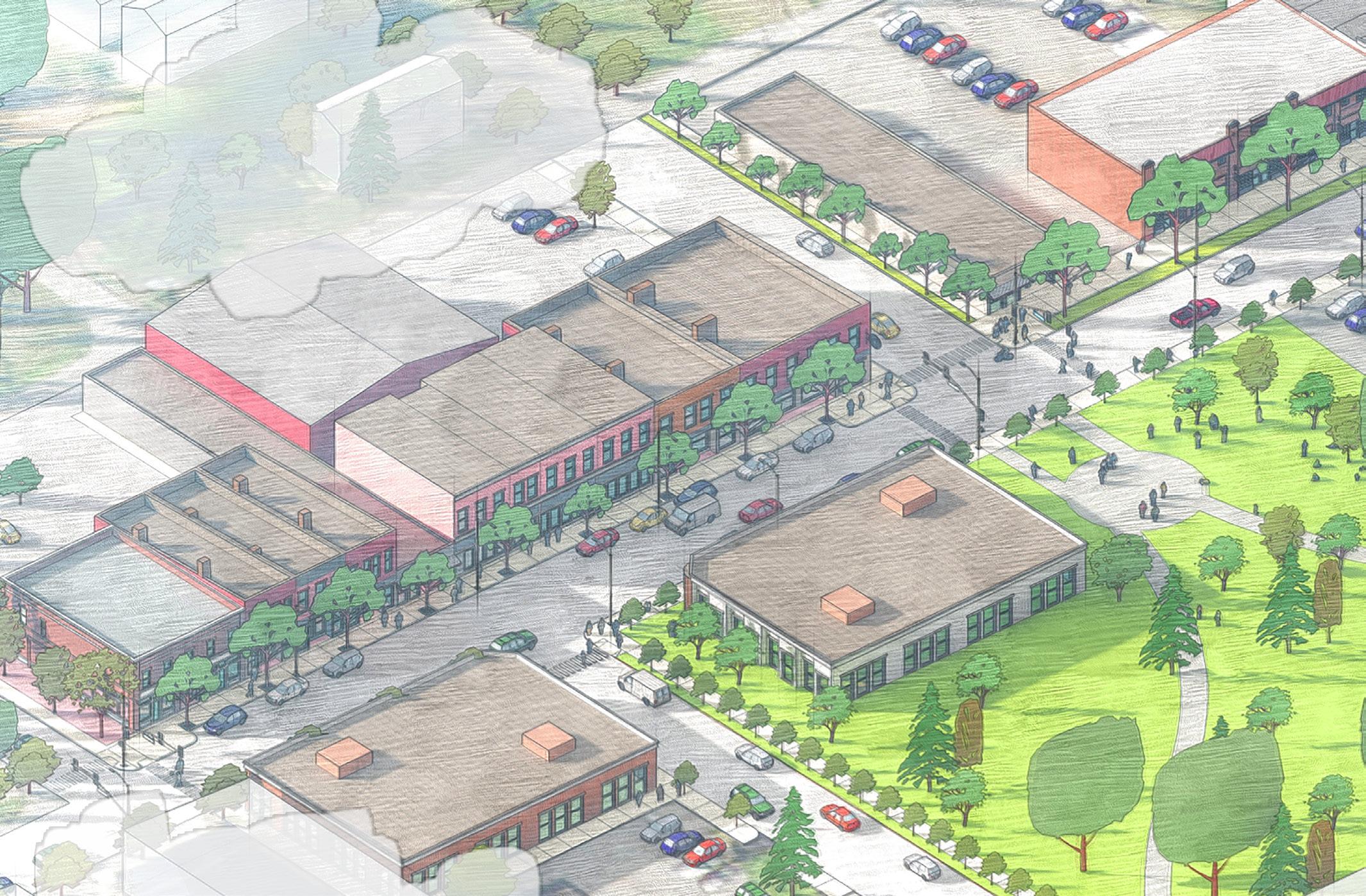
Key Goals
• Promote mixed-use property development
• Support affordable housing development
• Enhance sidewalks and streets to promote pedestrian safety
Key Strategies
• Reinforce the mixed-use commercial and residential context of the Fairfield and Taylor Street corridors
• Allow for new structures to be constructed with minimal setbacks that support the form of the neighborhood
• Encourage new structures to be constructed in a way that enhances the existing built form (no more than three stories)
• Promote rezoning Fairfield Avenue from, Industrial and Commercial to Urban Corridor
• Alleviate unnecessarily high parking requirements for new construction to support the dense urban fabric of the Fairfield Corridor
• Support new residential development as neighborhood infill on Malita, Bass, Brandriff, Masterson, Williams, Butler, Poplar, Dewald, Webster, Hoagland and Prince
packard arts
Re-envision a new urban fabric around the improved Packard Park, while supporting it as a public space for a diverse and inclusive population. Encourage the development of mixed-use projects that include new, permanently affordable housing and a commercial, artist, and maker space along the vibrant Fairfield Corridor.
Vacant or underutilized land is interspersed with commercial structures that are not beneficial to the neighborhood. While the area has seen little in new construction, two existing park spaces, a regional art gallery, and new small commercial spaces provide the vibrancy that residents seek. Packard Park (City) and Lutheran Park (Private) are at the center of this area. Both provide space to nearby residents and businesses and a central place for several neighborhoods to gather and collaborate.
Key Goals
• Promote mixed-use property development

• Support affordable housing development
• Enhance sidewalks and streets to promote pedestrian safety
• Leverage redevelopment of vacant spaces to provide community-oriented uses that enhance the nearby arts and creative spaces
Key Strategies
• Reinforce the mixed-use commercial and residential context of the Fairfield corridor
• Allow higher-density mixed-use along Fairfield Avenue
Irishtown Cultural District
Packard 2030 45
Rendering by Jeffery Tompkins
Packard Arts District
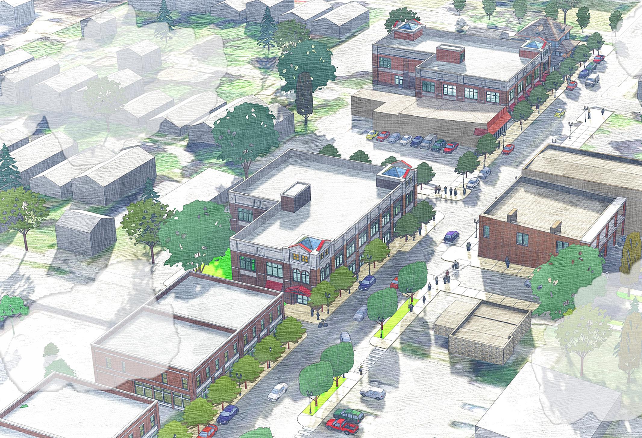
Rendering by Jeffery Tompkins
Broad River Corridor District

Rendering by Jeffery Tompkins

Packard 2030 46
Packard Strategic Development Areas
Map shows priority areas for redevelopment

Packard 2030 47
• Promote and incentivize non-residential uses identified by the community as priorities on Fairfield Avenue
• Maintain existing Urban Corridor Zoning
• Allow for new structures to be constructed with minimal setbacks that support the form of the neighborhood
• Enhance both pedestrian and driver safety along both the Fairfield Avenue corridor and neighborhood streets
• Explore reductions in residential parking requirements, as appropriate
broad river
With its proximity to the newly repurposed Electric Works campus, and the high volume of people who travel the corridor each day, it is important to continue the urban corridor fabric south along Broadway to Park Avenue where the commercial district abuts the residential neighborhoods. This corridor serves not only those traveling to destinations, but also the residents of Creighton Home, Poplar, Broad River, and South Wayne with laundry facilities, restaurants, professional offices, and convenience stores. South of its intersection with Creighton, Broadway should evolve into a vibrant mixed-use area featuring first-floor commercial and institutional spaces with upper-level residential supporting gentle density for nearby neighborhoods.
Several vacant and underutilized properties line the corridor, creating a sense of ‘missing teeth’ on what could be a vibrant, walkable, neighborhood node. As the population continues to increase at Electric Works, the properties along Broadway will continue to increase in value. Ensuring that this segment of Broadway is used for appropriate mixed-use will be critical to the well-being of the nearby neighborhoods. Notably, the corridor lacks public space amenities, and it should be considered a prime location for development as space becomes available; otherwise, beautification and pedestrian enhancements should be prioritized.
Key Goals
• Promote mixed-use property development, especially north of Park Avenue
• Support affordable and workforce housing development and maintenance programs for existing housing stock
• Enhance sidewalks and streets to promote pedestrian safety
Key Strategies
• Reinforce the mixed-use commercial, and residential context of the Broadway corridor
• Promote and incentivize non-residential uses identified by the community as priorities on Broadway
• Promote and incentivize multi-family structures that encourage gentle density along with Broadway
• Encourage rezoning a portion of the corridor to Urban Corridor
• Allow for new structures to be constructed that support the form of the existing setbacks
• Enhance both pedestrian and driver safety along both the
• Broadway corridor and neighborhood streets
• Explore reductions in residential parking requirements, as appropriate
zoning
Zoning is a powerful tool used to direct the future form of a community that serves to improve and protect current and future development within the Packard Area. Throughout the planning process, residents expressed concerns that zoning standards were not meeting the needs of neighborhoods, which caused some concern about future growth strategies. By examining and implementing zoning modifications to support the neighborhoods productively, the urban and pedestrian-oriented built form should be preserved and accessible.
GOAL FOUR:
Enhance, Improve And Protect Neighborhood Character And Property Values Through The Application Of Appropriate Zoning Tools And Improved Enforcement Of Zoning Ordinance Provisions
4.1 Encourage the application of Urban Corridor (UC) designation to specific locations along commercial corridors to enhance and preserve existing urban scaled, pedestrianoriented, mixed-use corridors
• 4.1.1 Irishtown Cultural District
• 4.1.2 Broad River Corridor District
4.2 Ensure screening and buffering standards are consistently enforced on commercial properties adjacent to residential zoned neighborhoods
4.3 Encourage the adaptive reuse of vacant and underutilized commercial, institutional, and industrial buildings for residential, commercial, or mixed-use purposes
• 4.3.1 Develop a map of existing vacant and/or underutilized structures within the Packard Area
• 4.3.2 Work with organizations and realtors to market available property in the Packard Area for redevelopment
4.4 Evaluate zoning and land-use conflicts in the Packard Area and prioritize areas for zoning district modifications
• 4.4.1 Develop a map of existing non-conforming uses
• 4.4.2 Work with neighborhood association(s) to inform property owners and residents on the importance of matching zoning with the current use
Packard 2030 48


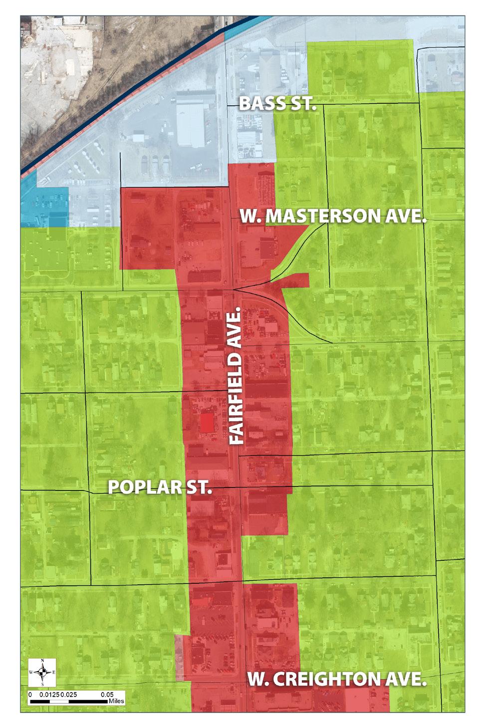


Packard 2030 49
health & safety GOAL FIVE:
The physical design of neighborhoods can have a significant effect on crime rates and health outcomes, and in turn, both can influence the neighborhood’s physical design. Through a series of physical and programmatic interventions, the Packard Area can break down neighborhood isolation, improving the overall quality of life. The underlying approaches of the following recommendations use a series of design principles throughout CPTED (Crime Prevention Through Environmental Design) and SDOH (Social Determinants of Health). Both of these emphasize a variety of people-centric techniques to design and activate the built environment to improve the health and safety of neighborhood residents.
Provide A Sense Of Improved Health, Safety, And Security For Both Residents And Businesses
5.1 Encourage improvements to the physical and built environment to promote a sense of safety
• 5.1.1 Educate residents on how to incorporate Crime Prevention Through Environmental Design (CPTED) principles to promote a safe environment for both residents and businesses
• 5.1.2 Encourage the repair, replacement, and general upkeep of buildings and common spaces to reduce the opportunity for crime
• 5.1.3 Encourage residents to report building code issues to the City when appropriate.
• 5.1.4 Street lighting should be improved in areas that have inadequate lighting
• 5.1.5 Encourage property owners to install exterior lighting and home monitoring/security devices to deter/prevent criminal activity
• 5.1.6 Seek grants for CPTED improvements in all Packard Area neighborhoods
5.2 Partner with the City’s Public Safety Divisions to monitor and communicate safety issues in the Packard Area
• 5.2.1 Ensure regular appearances of public safety officials at neighborhood meetings and coordinate neighborhood walks
• 5.2.2 Provide updated crime data and maps to target crime prevention programs
• 5.2.3 Promote fire safety and prevention programs, especially promotion of smoke alarms and carbon monoxide alarms
• 5.2.4 Seek grant funding to improve home and business fire prevention
5.3 Provide resources to promote healthy lifestyles
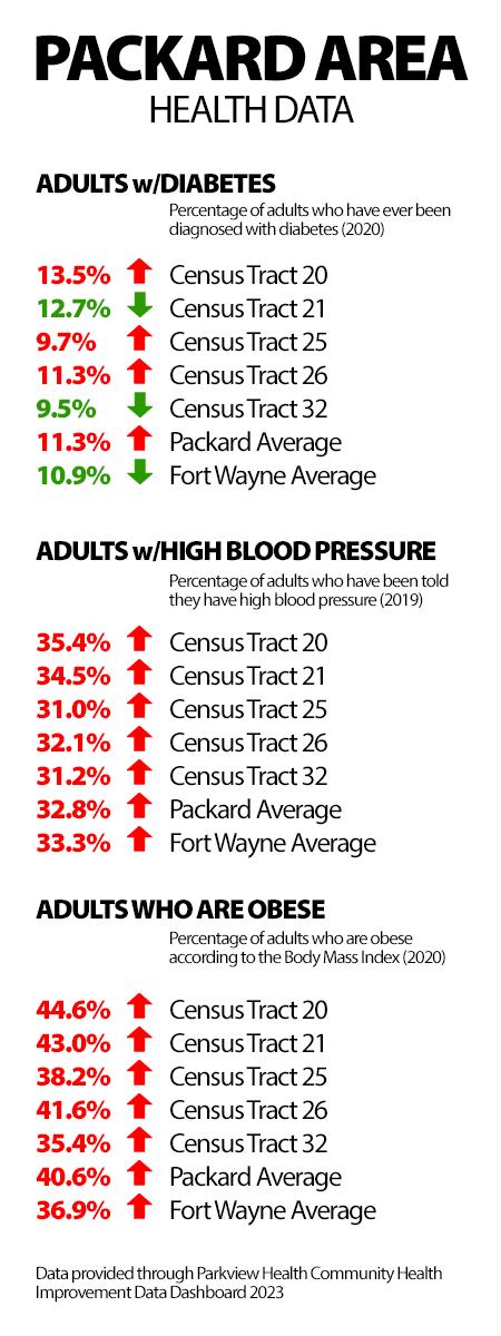
• 5.3.1 Support opportunities for residents to garden and grow fresh produce, either in community gardens or on personal property
• 5.3.2 Support composting initiatives for neighborhood associations
• 5.3.3 Encourage health-related organizations to develop education and outreach programs that promote healthy lifestyles at Bass Playground, Miner Playground, Packard Park and Kettler Park
Packard 2030 50
NEIGHBORHOOD CHARACTER
Ensuring diversity and celebrating neighborhood character is a focus for the Packard Area based on the shared responses through the community engagement process. Discussed in the following pages are three primary goals:
• (1) Preserve and Promote the Historical Character of the Packard Area, which promotes the idea that historic preservation should be a tool that engages and supports the development of neighborhoods where residents of the community can enjoy no matter their background,
• (2) Celebrate Arts and Culture by showcasing the Packard Area’s vibrancy as both one of Fort Wayne’s leading artist communities as well as its cultural heritage, and
• (3) Cultivate inclusive neighborhoods as the population diversity continues to grow. Neighborhood Character is one of the most equity-focused sections of the plan and ensures that recommendations can be implemented and celebrated by residents of all neighborhoods.
Sustainability: Using the lens of sustainability, we must recognize that historic preservation and culture both have a direct impact on promoting economic growth and environmental sustainability. For this reason, it is essential to support continued efforts that preserve cultural identities, historic assets, and neighborhood stories so they can continue to deliver benefits to residents and businesses for years to come.
Equity: Using the lens of equity, the diversity of the Packard Area’s neighborhood(s) and residents is a tremendous asset to the community. Ensuring that the neighborhood(s) are welcoming, inclusive, and celebratory of a wide variety of people will help foster and create a community that thrives both economically and socially.
Packard 2030 51
More than fifty percent of the responses in the community engagement process recognized the role and importance of historic preservation in the Packard Area. The average age of homes ranges from 100 to 150 years, making the historic character of Packard Area neighborhoods critical to the identity of the area. When a neighborhood retains significant historic structures, they create a local character that is often defined on a human scale, encouraging walking, biking, and other forms of interaction that build trust, relationships, and ultimately social capital. The physical sense of neighborhood cohesion can enhance community stability while reinforcing desirable social networks that strengthen community bonds.
GOAL ONE:
Preserve And Promote The Historical Character Of The Packard Area
1.1 Encourage maintenance and rehabilitation efforts that maintain the historic character of neighborhood areas
• 1.1.1 Create a centralized hub of educational materials to maintain and rehabilitate historic structures
• 1.1.2 Host annual workshops for property owners that showcase tips and methods on how to maintain historic properties
• 1.1.3 Encourage property owners to consider energy-efficient improvements that support the historic character of their neighborhood and improve the value of historic properties
1.2 Promote programs that educate residents about historic preservation and rehabilitation and/or adaptive reuse of historic structures
• 1.2.1 Seek funding through grants to promote programs that assist with historic preservation efforts
• 1.2.2 Promote educational resources and materials for historically designated property owners
1.3 Ensure the practice of historic preservation and protection of community assets is for everyone
• 1.3.1 Support efforts by the City’s Historic Preservation Commission to improve inclusivity and equity for historic preservation in the Packard Area
• 1.3.2 Be intentional and proactive in forming partnerships with groups that have either been marginalized or are not actively sought out to discuss historic preservation
• 1.3.3 Identify and document assets and locations that may not traditionally be recognized with historic significance
1.4 Educate both residents and building owners about the Packard Areas’ historic assets
• 1.4.1 Encourage the City’s Historic Preservation Commission to complete a social and economic benefit analysis of historic preservation in the Packard Area
• 1.4.2 Work with the City’s Historic Preservation staff to ensure materials promoting the process and value of historic preservation is available in both English and Spanish
• 1.4.3 Share educational material on the social and economic value that historic preservation provides
• 1.4.4 Actively support and promote events that promote historic properties and neighborhoods
1.5 Support the designation of National Register Districts, Local Historic Districts, Conservation Districts, Heritage Districts, and Commercial/Institutional Landmark properties
• 1.5.1 Provide ongoing education to neighborhoods and property owners on the process and benefits of being listed as a historic neighborhood asset
• 1.5.2 Encourage and support eligible neighborhoods and property owners to work with the City’s Historic Preservation staff and seek listed status
• 1.5.3 Utilize the Packard Area website, neighborhood newsletters and social media to promote the historic designation of the neighborhoods and properties
• 1.5.4 Work with the City’s Community Development staff, cultural organizations, and neighborhood residents to explore the benefits of listing Broad River, Creighton Home, Hoagland Masterson, Poplar and West Rudisill neighborhoods as a Conservation District to support neighborhood stabilization
• 1.5.5 Work with the City’s Historic Preservation staff, Community Development staff, Cultural organizations, and neighborhood residents to support a pilot Heritage Cultural District called ‘Irishtown’ that overlaps the Hoagland Masterson and Poplar neighborhoods
1.6 Ensure that neighborhood associations in the Packard Area are particularly aware and sensitive to historic preservation issues and the appropriate rehabilitation of historic properties
• 1.6.1 Facilitate discussions between neighborhood groups and development entities to ensure the neighborhood retains its historic character
• 1.6.2 Routinely monitor projects in the Packard Area to ensure they meet the Historic Preservation Commission guidelines and/or the Secretary of Interior’s Standards where applicable
Packard 2030 52
preservation
Historic Preservation
Map shows current and eligible Historic Districts


Packard 2030 53
arts & culture
At the heart of the Packard Area is a growing, vibrant arts community that can be experienced through murals along the Fairfield Avenue corridor and several diverse cultures that have found the neighborhoods to be a welcoming home. Survey respondents expressed growing support for the arts and culture and saw both as valuable assets for the neighborhood(s). Celebrating the arts adds meaning to the Packard Area by reflecting on its rich cultural identity and narrating the built environment in an approachable way. A strong cultural identity can foster and empower a neighborhood, influence one’s perception of opportunities, and, most importantly, build strong and resilient social capital.
GOAL TWO: Celebrate The Rich Arts Community And Cultural Identity Of The Packard Area
2.1 Promote the Packard Area’s role as a cultural and artistic hub of the City
• 2.1.1 Support the implementation of the Fort Wayne Public ‘Art for All’ Master Plan’s projects and programs that specifically apply to the Packard Area
• 2.1.2 Utilize existing neighborhood infrastructure to support public art projects that orient visitors and residents to the history and story of the neighborhood(s)

• 2.1.3 Identify locations of cultural significance in order to protect and enhance these spaces for the benefit of neighborhood residents and businesses
• 2.1.4 Consider the establishment of the Packard Area Cultural District in partnership with Arts United of Greater Fort Wayne and the Indiana Arts Commission
• 2.1.5 Connect artists to affordable housing opportunities, and explore affordable live-work housing supportive of artmaking and creating
• 2.1.6 Identify resources to support and promote the artist community
2.2 Encourage the development of community events to build intergenerational and multicultural relationships that celebrate the diversity of the Packard Area
• 2.2.1 Establish a Packard Area Planning Alliance Programming Committee that develops, facilitates and maintains community events
• 2.2.2 Ensure marketing materials for community events are provided both in print and on the Packard Area website and are offered in both English and Spanish to ensure community events are available to neighborhood residents
2.3 Establish a cultural heritage district in the Packard Area
• 2.3.1 Develop a brand/identity for Fort Wayne’s historic Irish settlement located in the Hoagland Masterson and Poplar neighborhoods
• 2.3.2 Incorporate appropriate wayfinding, historical and destination signage establishing Irishtown
• 2.3.3 Actively promote the Irishtown area as a key cultural destination
• 2.3.4 Seek grant funding to develop and promote historic and cultural programs for Irishtown
Murals on Storefront
Packard 2030 54
Josh Campbell, City of Fort Wayne
Organizational inclusivity requires both a look from inside and outside each neighborhood. The Packard Area features multiple international communities, languages, and social identities, each of which should be recognized and celebrated. At the larger organizational level, these attributes strengthen the organization when strategies are implemented, and at the neighborhood level, ensuring active neighborhoods is key to being an inclusive community. Providing neighborhoods with a collective voice and the tools necessary to improve their efforts is central to the inception of the Packard Area Planning Alliance. The Packard Area has a strong network of local organizations that promote local arts and culture and improve health, safety, and economic outcomes. The success of Packard 2030 lies not only in the willingness of the City agencies to carry forward their commitments but also in the ability of residents and organizations to oversee its implementation.
GOAL THREE: Cultivate Strong And Inclusive Neighborhoods
3.1 Strengthen the Packard Area Planning Alliance organization so that it fosters diversity and inclusivity among its member neighborhoods
• 3.1.1 Establish a new Packard Area Planning Alliance subcommittee focused on developing and maintaining marketing and outreach material
• 3.1.2 Welcome and engage diverse perspectives in public meetings, committees and the board to include those of different cultures, nationalities, race, languages, disabilities and LGBTQIA+
• 3.1.3 Increase outreach to diverse communities to stimulate volunteer recruitment and neighborhood participation
• 3.1.4 Utilize the Packard Area website, as well as neighborhood newsletters and social media to promote projects and programs that support and recognize culture and diversity in the community
• 3.1.5 Encourage communication and outreach efforts within the Packard Area are equitable and accessible to neighborhood residents, businesses and organizations
• 3.1.6 Develop a framework for marketing and outreach to ensure that the organization and member associations prioritize equity and inclusivity in print, social media and online materials
 Illsley Place Neighborhood Banner
Packard 2030 55
John Felts, City of Fort Wayne
neighborhoods
3.2 Strengthen and activate neighborhoods within the Packard Area
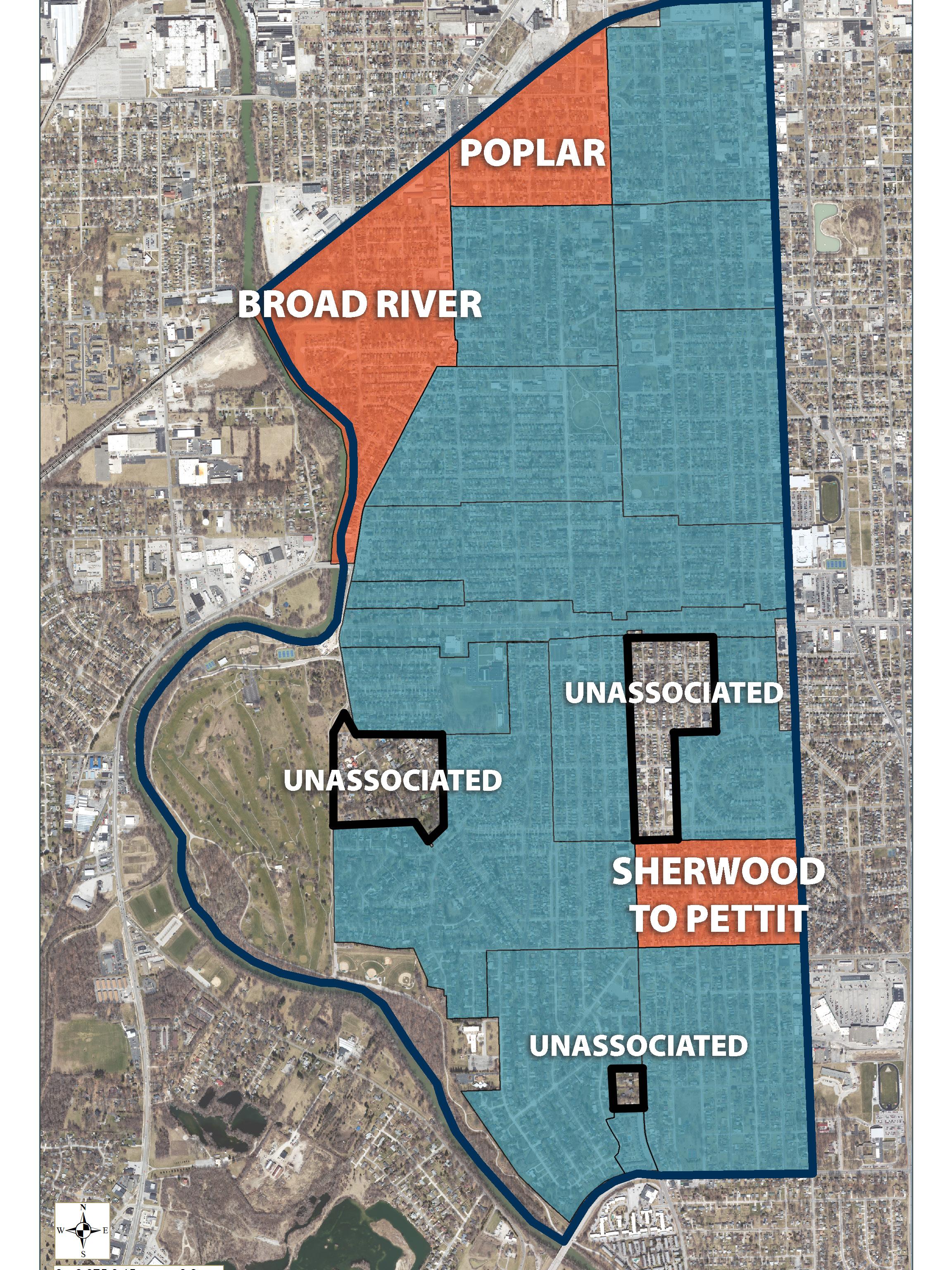
• 3.2.1 Administer a leadership development program to support neighborhood associations in the ability to build capacity
• 3.2.2 Assist in the development and/or re-activation of neighborhood associations in the Broad River, Poplar, and Sherwood to Pettit neighborhoods
• 3.2.3 Consider working with existing neighborhoods to incorporate nearby areas that are not currently represented by any neighborhood association
Neighborhood Activation
Map shows non-active and unassociated areas of Packard
Packard 2030 56
NEIGHBORHOOD PUBLIC REALM
Promoting an enhanced and robust quality of life in the Packard Area requires that residents and visitors can access and enjoy the amenities that neighborhoods and public spaces have to offer. There are two primary goals:
• (1) Neighborhood Mobility, which focuses on transportation infrastructure and connectivity, and
• (2) Neighborhood Parks and Open Space, which promotes some of the Packard Area’s most prized assets, its park system. Each goal considers the lenses of sustainability and equity, equally important concepts that should be applied to all projects and programs implemented in the Packard Area.
Sustainability: Using the lens of sustainability, in order to promote safety and well-being, this plan recommends implementing environmental and infrastructure improvements, as well as programs that promote activity in the public realm which have been demonstrated to (1) improve health, and (2) reduce the proliferation of crime. The increased use of public transportation along with the installation of green and blue infrastructure, will ready Packard Area neighborhood(s) to better absorb population growth. Improved transportation and infrastructure can also help to offset changes (i.e. increased stormwater runoff, traffic congestion, sedentary behavior, and smog) that can impact health outcomes for area residents.
Equity: Using the lens of equity, we believe that safety, wellness, and mobility are essential components of creating equitable communities where all residents can participate, prosper, and reach their full potential. This is why the Neighborhood Public Realm section recommends implementing place-based measures that will improve access to public and multimodal transportation options, as well as public spaces and amenities that promote health and social interaction.
Packard 2030 57
mobility
Walkability, accessibility, traffic issues, and public transportation were discussed throughout the engagement process, all associated with neighborhood mobility. Ensuring neighborhood residents can access their daily needs within 15-minutes requires safe, navigable, and reliable transportation and mobility options, using a series of roadways, sidewalks, trails, and public transportation alternatives. Residents can enjoy safer and more convenient access to their destinations by improving and enhancing neighborhood mobility, connectivity, and infrastructure.
GOAL ONE: Improve Neighborhood Mobility, Connectivity, And Transportation Infrastructure
1.1 Establish safe, clearly marked pedestrian and bikeway routes to better connect neighborhoods and destinations
• 1.1.1 Improve pedestrian safety and visibility with improved crosswalk locations at:
• Broadway and Cottage (South Wayne Elementary)
• Fairfield and Packard (Packard Park)
• Fairfield and Sherwood (Harrison Hill Elementary)
• Rudisill and Hoagland (Harrison Hill Elementary)
• Creighton and Miner (Miner Playlot)
• Creighton and Hoagland
• 1.1.2 Improve walking conditions in the Packard Area by closing existing sidewalk gaps on:

• Buell
• Fairfield
• Lexington
• Pettit
• Wildwood
• 1.1.3 Improve bicyclist safety and visibility by ensuring bike lanes and bike routes are marked along Rudisill Boulevard between the River Greenway and Calhoun Street
• 1.1.4 Support the addition of a new north-south bike lane that connects bicyclists from Rudisill Boulevard to downtown using Harrison Street

• 1.1.5 Support the addition of a shared bicycle path on Sherwood Terrace
• 1.1.6 Encourage neighborhood associations to work with supporting organizations to complete an annual sidewalk audit and report findings to the City to prioritize sidewalk improvements
Existing Sidewalk Gaps
Maps show where new sidewalk should be considered
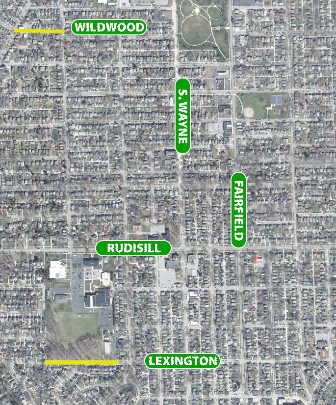
Proposed Harrison Street Bike Lane
Rendering by Jeffery Tompkins
Packard 2030 58
School Walkshed
Boundaries show a 10-minute walk from educational facilities

Packard 2030 59
1.2 Increase access to and encourage the use of public transportation
• 1.2.1 Provide safe pedestrian access and, where relevant, comfortable walking areas, ADA ramps, appropriate lighting, and bus stop signage at Citilink bus shelter and bus stop locations
• 1.2.2 Partner with Citilink to provide information to Packard Area residents on the economic, health and environmental benefits of using public transportation
• 1.2.3 Establish a program in partnership with Citilink that provides periodic incentives for neighborhood residents to consider public transportation
• 1.2.4 Encourage and advocate for increases in funding to expand fixed-route public transportation routes and service.
1.3 Promote and support road improvements that enhance the safety of neighborhood streets for all residents
• 1.3.1 Develop an annual list of temporary pilot projects that calm and/or reduce traffic on neighborhood streets that can later be explored for permanent installation
• 1.3.2 Evaluate the potential for converting existing one-way streets in specified areas to improve neighborhood safety and access
• 1.3.3 Add and/or replace concrete curbs and medians on Fairfield Avenue between Bass Street and Paulding Road
• 1.3.4 Encourage the rehabilitation of streets, curbs, alleys and sidewalks and retaining walls in the Broad River and Poplar neighborhood(s) to enhance connectivity from the Packard Area to Electric Works

• 1.3.5 Develop a curb painting program to maintain and enhance the visibility of alleys and intersections
• 1.3.6 Encourage the continued maintenance of neighborhood alleys and sidewalks
1.4 Support the development of long-term improvement strategies to existing transportation, water and sewer infrastructure and utilities
• 1.4.1 Create a long-term neighborhood improvement strategy for stormwater, utility and transportation in FairfieldTerrace-Belmont
• 1.4.2 Encourage the development of rain gardens and appropriately design ponds to support stormwater runoff and management
1.5 Continue working to enhance the aesthetic appearance of gateways to the Packard Area
• 1.5.1 Encourage the establishment of landscaped and signed gateways near Fairfield at Taylor, Fairfield at Airport Expressway, Broadway at Creighton, and Broadway at Bluffton
road priorities
The Packard Area serves as a gateway to Downtown Fort Wayne connecting the core of the city to key assets such as Fort Wayne International Airport, Interstate 69 and Interstate 469. While each connecting thoroughfare carries thousands of vehicles each day, they still serve a critical role for the neighborhoods in which they touch. The following three roads should be studied for further improvements:
IRISHTOWN
Continue intersection and pedestrian safety improvements on Fairfield at Locust, Masterson, Taylor, Williams, Walnut, Butler and Dewald
BLUFFTON BRIDGE
With bridge and roadway enhancements coming to the Bluffton Road Bridge, intersection and pedestrian safety improvements on Broadway at Rudisill, Illsley, Bluffton, Oakdale, Nuttman and Kinsmoor should be prioritized
WEST PAULDING
Along the southern border of the Packard Area, West Paulding connects visitors from the Fort Wayne International Airport to Downtown passing by several community institutions and neighborhoods. Intersection and pedestrian safety improvements should be considered at Fairfield, Buell, Hoagland, Webster, Harrison and Calhoun
Irishtown Pedestrian Improvements
John Felts, City of Fort Wayne
Packard 2030 60
Access to recreation and exposure to green spaces are crucial to strong, healthy, vibrant, and livable neighborhoods. Great public spaces and community parks are places where residents can gather, participate and contribute to the identity of a neighborhood. The Packard Area features several great open spaces, including the namesake Packard Park located at the heart of the neighborhood, Foster Park, which shares a western border with the St. Mary’s River, Kettler Park on the southern end, and both the Bass and Miner Playlots which serve the nearby neighborhoods with ample open space for outdoor recreation. Throughout the engagement process, neighborhood parks and open spaces were considered crucial ingredients to quality of life.
public space GOAL TWO: Support The Growth And Maintenance Of Parks, And Open Spaces
2.1 Ensure that existing parks, playgrounds, and open spaces are upgraded and maintained to a high standard
• 2.1.1 Advocate for improvements at Kettler Park, West Rudisill Park, Bass and Miner Playgrounds
• 2.1.2 Advocate for the continuous upgrades of existing facilities at Foster Park
• 2.1.3 Incorporate principles of universal design (accessibility) in equipment and landscape upgrades at all neighborhood parks, playgrounds, and open spaces
Safety Signage for Neighborhood Park
John Felts, City of Fort Wayne

Packard 2030 61
Park Walkshed
Boundaries show a 10-minute walk from neighborhood parks

Packard 2030 62
• 2.1.4 Provide support and advocacy for new/additional funding to implement recommendations in the City’s Parks & Recreation Department master plans
• 2.1.5 Educate and encourage residents to report maintenance and safety issues to the City’s Parks & Recreation Department
2.2 Implement the recommendations from the Packard Park Master Plan

• 2.2.1 Provide appropriate connections into the park from the neighborhood by establishing connection points and ensuring there is a circulation system within the park
• 2.2.2 Engage the community with an event space that will accommodate a diverse range of activities
• 2.2.3 Foster a sense of place, through improving the aesthetics within and around the park, by paying special attention to beauty and the history of the site
2.3 Ensure that existing parks, playgrounds, and open spaces are physically accessible to all modes of travel from adjoining neighborhoods, schools, and corridors
• 2.3.1 Prioritize and develop multimodal routes to and from existing parks and recreational facilities
• 2.3.2 Create signage that promotes and informs of multimodal options to parks and recreational facilities (i.e., distance on foot, distance on the bike, etc.)
2.4 Ensure that all Packard Area residents have access to quality programming and recreational opportunities in existing parks, playgrounds, and open spaces
• 2.4.1 Incorporate the data from the Parks & Recreation Needs Assessment survey as part of the development of recreational and educational programming
• 2.4.2 Partner with local agencies and organizations to provide additional programming in parks, playgrounds, and open spaces
• 2.4.3 Promote recreational activities through the new Packard Area Planning Alliance website
• 2.4.4 Regularly complete use needs surveys to intentionally provide inclusive programs for a diverse population
2.5 Increase and Enhance the tree canopy throughout the entire Packard Area
• 2.5.1 Conduct a tree cover/pit survey
• 2.5.2 Increase the tree canopy cover by twenty (20) trees per year for the next ten years
Packard Park
Packard 2030 63
John Felts, City of Fort Wayne

Packard 2030 64
Packard 2030 65

Packard 2030 66

Packard 2030 67
PACKARD 2030


 Hoagland Masterson Neighborhood


 Commercial Shops at Irishtown


 Illsley Place Neighborhood Banner


