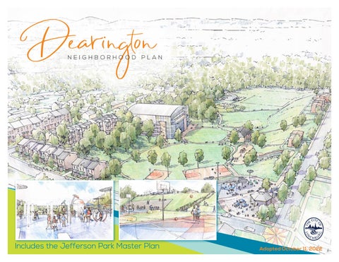
16 minute read
STREETS & ACCESS


Transforming Dearington into a neighborhood that is not burdened by its history of landfi lls but is able to celebrate and enjoy valuable public spaces and an improved quality of life requires strong connections. Improving neighborhood streets and access creates a holistic system that considers how neighbors reach these facilities as much as what they do once they get there. While the recommendations included in this section are included in this plan as they increase recreational access and opportunities, there is a second benefi t. Th ese improvements also provide safer, more inclusive transportation options for reaching jobs, commercial areas, and services.
OVERALL NETWORK
Th e network map highlights key streets and new trail connections to create a well-connected transportation system that helps neighborhood residents reach area destinations and park facilities as well as improves safety on known cutthrough streets: Caroline, Page and Chambers.
Loops
Loop trails of all sizes, as short as 1/10 of a mile or as long as several miles, are valuable recreational amenities for accommodating all ages and abilities. Th e proposals for Jeff erson Park include short loops for walking. Longer loops can be developed by including on-street facilities that tie to other off -street trails and new access points.
New and Improved Off-Street Trails and Access Points
JEFFERSON PARK. Paved trails in a variety of short sizes. Outdoor fi tness equipment stations will be available along them.
MATERIALS STORAGE SITE TRAIL
(new access point). Restore an earthen trail that once tied the Dearington and Tinbridge Hill neighborhoods together. Th is trail should connect to the paved Kemper Street Trail.
KEMPER STREET TRAIL SPUR (new access point). Pave an existing access road and provide access through the Public Works Site to Chambers Street. Include parking at the trailhead. (more details in Chambers Street Gateway section)
CENTRA HEALTH TRAILS (new access points). Work with Centra Health to provide earthen trails across City and Centra Health property that connects Dearington to the hospital area. Off er a new access point on Caroline Street through the unopened Blue Street right-of-way.
CREEKSIDE TRAIL. At the bottom of Th ompson Drive, a relatively fl at gravel trail ties into the Point of Honor Trail. Paving this segment provides a smooth loop for bikers and walkers.
Existing Trail Network and Neighborhood Park Amenities. Despite proximity to the Kemper Street Trail, there is no readily available access point. Proposed Trail Network

On-Street Trails
Improved on-street pedestrian and bicycle accommodations can help connect desired trail loops, and improve safety. Depending on the available space, amount of traffi c, and neighboring land use, a variety of accommodations can be considered.
Types MULTI-USE TRAILS. In areas with lower volume pedestrian and bicycle traffi c and narrow space to work within, combining both pedestrian and bicycle infrastructure into one facility may be a viable option. An on-street, multi-use trail provides a safe space for active transportation, separate from vehicular traffi c. People may walk and bicycles may pass them by entering the opposing lane when it is safe to do so. Varying speeds and sight distance for downhill and uphill travel should be considered with the construction of these facilities.
CYCLE TRACKS. Th ese facilities are exclusive bicycle facilities that provide the experience of traveling on a separated path or trail but are provided along streets. Unlike a multi-use trail, space is not shared with pedestrians. Th ey can take a variety of forms by being one or two-way and be at street, sidewalk or an intermediate level. Th e key is that they provide a higher level of security than bike lanes by being physically separated from vehicular traffi c and parking with vertical barriers like bollards or curbing raising them up.
BIKE LANES. Where existing sidewalks can accommodate pedestrians and pavement width can either be easily expanded or reassigned, bike lanes may be the best trail accommodation, providing separate spaces for bicyclists in each direction, traveling with traffi c. Adding buff ers provides greater distance between moving traffi c or parked cars and should be included wherever possible.

Multi-use trail on Odd Fellows Road in Lynchburg

Sharrows on neighborhood streets with speed humps Source: bikeportland.org
SIDEWALKS AND SHARROWS. On neighborhood streets, where narrow pavement width, combined with on-street parking helps keep vehicle speeds low, sidewalks for pedestrians and sharrow markings for bicycles may be all that is possible or necessary. While it is typically better to provide separated spaces for pedestrians, bicycles and vehicles, especially when kids may use the routes, calling attention to the trail with sharrow or trail markings, may be all that is realistic.


Various forms of cycle tracks and multi-use trail facilities
Corridors
PAGE STREET AND CAROLINE STREET.
A multi-use trail could be accommodated within existing pavement on Caroline to Patrick Street and by expanding Page Street.
YORK, CAROLINE, AND STONERIDGE
STREETS. In the residential areas, these neighborhood streets should include contiguous sidewalks and sharrow markings on the street pavement.
CHAMBERS STREET. Right-of-way will be needed but either cycle tracks with sidewalks or a multi-use trail should be incorporated to separate users from traffi c.
MEMORIAL AVENUE. Traffi c volumes should be studied here to determine if the number of vehicular lanes is truly necessary. Either buff ered bike lanes or a two-way cycle track could be accommodated by removing a travel lane.

Caroline Street looking towards Page Street
LANGHORNE ROAD AND PARK AVENUE
Langhorne Road has signifi cant traffi c volumes that requires it to maintain its current lane confi guration. Sidewalks are inconsistent and the street is diffi cult to travel along or cross when not in a vehicle. Cycle Tracks and sidewalks on both sides of the street should be considered to improve access here. Better, more frequent crossings, are needed to make the area more hospitable. Due to topography and rightof-way limitations, converting these streets to better accommodate all modes of travel will need to be a long-term project and require more study. In the near term, improvements to Page Street may be a better alternative to support multi-modal travel.

Langhorne Road in front of E.C. Glass High School
WHAT MAKES IT A TRAIL?
Facilities should be considered “trails” when they are either a primary route to a park facility, increasing park access, or are a segment of a recreational “loop.” Th ese facilities should receive special markings to designate them as trails and serve as a wayfi nding system that brings awareness to the nearby park property or the loop route. Th is can be done with a thermoplastic marker on the surface of the trail or sidewalk that uses the Department of Parks & Recreation branding scheme.


Potential surface graphics that use the Parks & Recreation Department logo to mark on and off -street trails and diff erentiate from other sidewalks and routes.
CAROLINE STREET GATEWAY
Th e intersection of Page Street with Hillcrest and Caroline Streets is a signifi cant gateway for the neighborhood. It sits just inside the neighborhood boundary and is the juncture of streets that connect the heart of the neighborhood to Memorial Avenue, E.C. Glass High School, and Lynchburg General Hospital. Page Street is used as a cut-through to quickly reach the hospital. Th is key intersection should be improved to provide better transportation infrastructure for non-car users and create a better sense of arrival for the Dearington neighborhood.
TRAIL. Due to limited right-of-way and constraining topography, the concept plan shows a multi-use trail on one side of Caroline Street and Page Streets to provide a safe connection to the hospital area. Th is uses the minimal amount of space to provide separated facilities as only one buff er (the space between the trail and the vehicular travel lanes) is needed. Once past Patrick Street and in the heart of Dearington, facilities will likely need to transition to sidewalks and sharrows due to the need for on-street parking and the presence of narrow streets. Traveling south of Caroline on Page Street, sharrows/bike lanes and sidewalks may be more feasible in the short term, working within the existing pavement width. A larger study will likely be needed to show how these accommodations carry users to destinations outside the neighborhood.
SIDEWALKS. Hillcrest Avenue is a primary entrance into the neighborhood and is narrow with inconsistent sidewalks. At a minimum, sidewalks need to be connected to provide a contiguous route to Langhorne Road. Street trees should be included as a buff er between pedestrians and traffi c.
North Page Street with multi-use trail EPR / Caroline Gaenzle
CarolineSt. 5’
Sidewalk 6”
HeaderCurb 10’
TravelLane 10’
TravelLane 6”2’
HeaderCurb RaisedBuffer 10’
Multi-UsePath
BUS STOPS. Route 1 bus stops here are used regularly by Page Street residents and should be improved to include shelters to facilitate use in all weather.
SIGNAGE AND AESTHETICS. As functional improvements are made to this intersection, landscaping, signage and opportunities to incorporate neighborhood character in street murals or crosswalks should be included.
Page Street north


Sidew
Sidewalk k


Caroline Street gateway improvements EPR / Caroline Gaenzle Concept showing gateway enhancements, improved bus stops, and on-street, multi-use trail, looking down Caroline Street into the Dearington Neighborhood. Hill Studio / Peter Giraudeau


Caroline Street gateway intersection
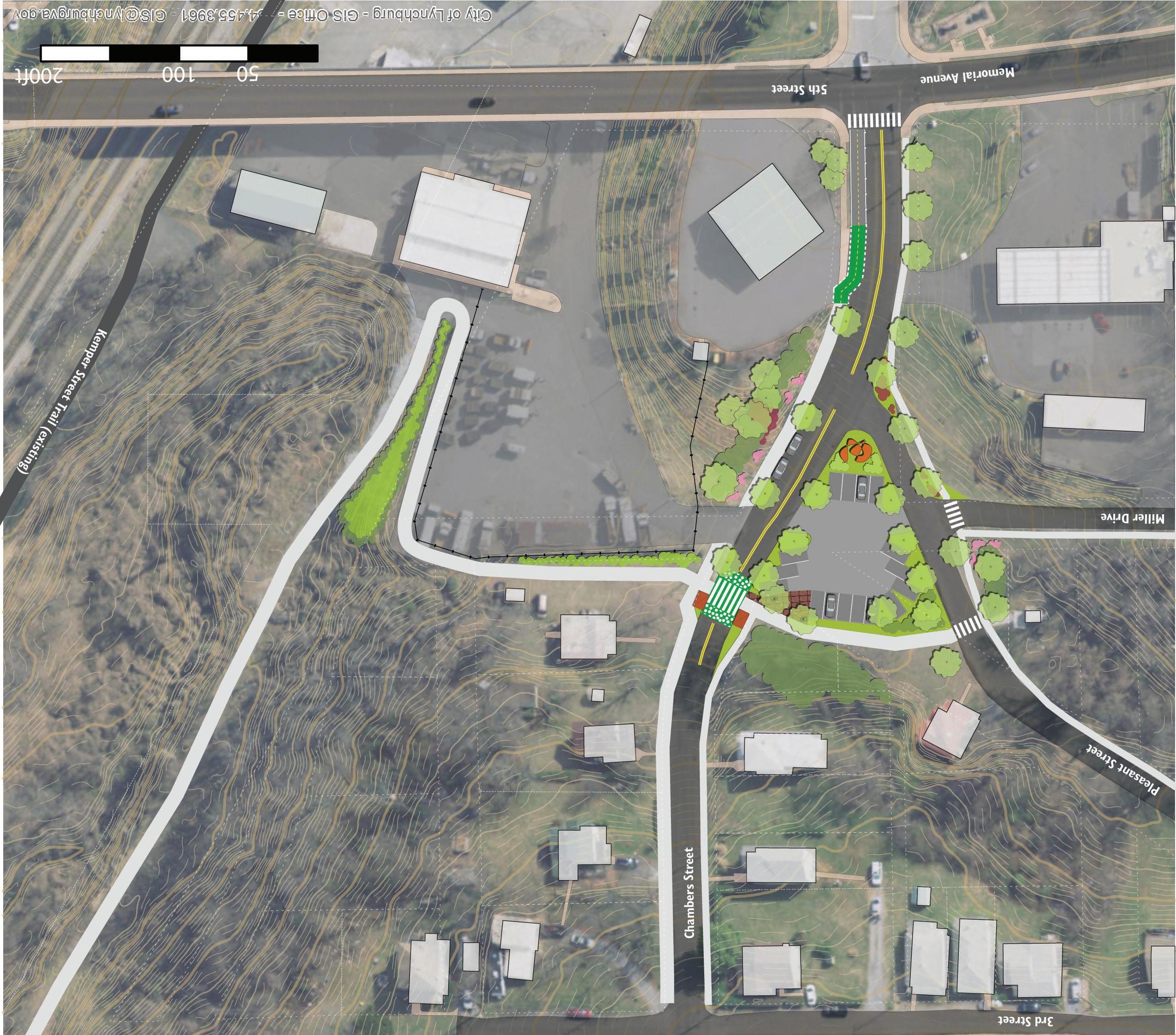
CHAMBERS STREET GATEWAY
Chambers Street appears to be the primary way most vehicles enter the Dearington Neighborhood and is the most direct way to reach the Dearington Apartments. It is also a bus route through the neighborhood. As the main gateway into Dearington, it is not particularly welcoming. It feels rather vacant and forgotten with empty land, a few of the nearby houses boarded up as part of the City’s Vacant Property Registration Program and chain link fence with barbed wire lining the right hand side, where the only sidewalk is. Overgrowth from the hillside is beginning to cover sidewalk, making walking particularly unpleasant.
Improving the gateway of the neighborhood will provide valuable transportation connections, generate a positive overall impression of Dearington and create a sense of arrival for all that Dearington has to off er.
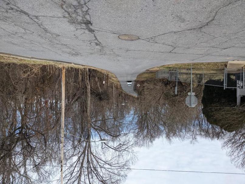
Kemper Street Trail Spur A moderately sloped gravel access road currently ties the City’s Public Works facilities at 1621 Memorial Avenue to the Kemper Street Trail in less than two tenths of a mile. Extending this trail up the access road and through the Public Works site would provide Dearington (and 5th Street/ Memorial Avenue) with a paved trail connection, a valuable asset to a neighborhood. Currently those wishing to use the trail would need to travel an extra mile to do so, to the Park Avenue access point, even though the trail passes under the 5th Street Bridge. A new trail access point here would provide an enormous recreational benefi t and also an active transportation connection to Downtown. Trail standards that would make this work eligible for grant funding and provide the needed maintenance space require approximately 20’ of width, with 5’ on either side of a 10’ wide trail. Routing this trail spur through the Public Works site would remove a signifi cant portion of the already limited space the department uses throughout the year for storage of vehicles, leaf boxes, dumpsters, etc. In order for this trail connection to be constructed, Public Works will need alternate accommodations for these operations. Th is will mean procuring another piece of property, repurposing property the City already owns, or possibly expanding this site to the north along Chambers Street, though the layout and topography there may not allow adequate space to be recovered.

Chambers Street Pedestrian Experience

Stormwater and CSO Disconnection Existing topography causes the Public Works Site to receive a signifi cant amount of stormwater runoff from the surrounding streets and neighborhood. Th e gravel access road pictured below, the proposed trail route, experiences regular erosion issues due to the stormwater fl ow through this site. During heavy rains it appears that a large volume of stormwater is not captured in the combined sewer system on the west side of Chambers Street and instead fl ows through the Public Works site towards this access road. Th is area therefore seems like an ideal candidate for a select CSO separation and stormwater management project to help meet the City’s MS4 requirements. Th e Public Works site appears to be well suited for underground storage of stormwater as that would allow operations on the surface to continue.


Stormwater from the Dearington neighborhood runs across Chambers Street and erodes the existing access road
new sidewalk
new sidewalk multi-use path to Jefferson Park and Dearington Apartments
trail parking
narrower intersections bus shelters and highly visible trail crossing
underground stormwater storage and treatment
new sidewalk
gateway sign public art chain link fence pulled away from road
low maintenance landscaping
street trees & parking
Chambers Street Gateway Concept Plan
transition to on-road bike facilities paved trail connection to Kemper Street Trail

Current Chambers Street neighborhood entrance


Chambers Street Gateway concept illustrating new public art, trail connectiosns, trail parking, sidewalks, and aesthetic improvements. Hill Studio / Peter Giraudeau Parking Area and Alternatives Th e concept plan shows a parking area for trail users; however, if parking could be located elsewhere, potentially at 91 Chambers Street, to avoid needing to cross Chambers Street to reach the trail, the “triangle” could be repurposed as either:
A SMALL PARK FACILITY. Jeff erson Park, DESI, and the Materials Storage site may provide Dearington ample park space. However, this location is more accessible to the commercial area and the front portion of the neighborhood. It would also provide an attractive entrance feature for the neighborhood. Specifi c programming and park needs are yet to be identifi ed for this site.
REDEVELOPMENT. Th e City may want to consider using its brownfi elds grant funds to explore this site and its redevelopment potential. It never appears to have been previously developed and only used for various storage activities over the years. Housing could be valuable located adjacent to the trail connection, a bus route, and Memorial Avenue.
Chambers Street parcel lines will need adjustment prior to redevelopment.
Street Improvements Th e roadway is wide near the City gas pumps at 1601 Memorial Avenue, at 35’ of pavement and 60’ of right-of-way, but narrows to 23’ of pavement and 40’ of right-of-way as drivers move in towards the neighborhood. Lane widths only need to be about 11’ here so there is an opportunity to narrow the space dedicated to vehicles and add bike facilities and/or parking to tie the trail spur to 5th Street.
SIDEWALKS. With the addition of the trail connection, neighborhood streets should be improved to include sidewalks and safely connect the neighborhood to the trail. As minimal parking is being provided here, residents should be encouraged to walk or bike to the trail connection, bus shelters, etc.
STREET TREES. Trees along Chambers Street where the width can accommodate them would help mark on-street parking space, provide shade and buff er the sidewalk to create a more welcoming gateway.
TRAIL CROSSING. Th e concept plan illustrates that should the Kemper Street Trail Spur need to cross Chambers Street to reach the parking area, a highly visible trail crossing should be installed. Mid-block crossings are not in line with past VDOT guidance for crosswalks, strongly encouraging crosswalks only be placed at “controlled” intersections (those with stop signs or lights). New guidance is expected from VDOT in 2021 regarding mid-block crossings and encouraging them to be placed where needed, provided sight distance allows pedestrians to safely cross in the location. Th is crossing will need to be studied further as plans and guidance evolve.

Chambers Street adjacent to the DESI playground where no pedestrian facilities exist.
CHAMBERS STREET MULTI-USE
TRAIL. Th is on-street trail connection should be made to tie the Kemper Street spur trail to Jeff erson Park. It also helps safely connect the neighborhood to both destinations. Chambers Street’s right-of-way width is variable and it will require working with property owners to gain the space needed to make this improvement.
INTERSECTION IMPROVEMENTS.
Both Miller Drive and Pleasant Street seem to have large curb radii that allow cars to speed through the area. Th ose could be narrowed and stops required as necessary. Aesthetic Improvements Th e existing chain link fence should be pulled away from the existing sidewalk to be minimally visible from the street. Landscaping on the hillside below the City gas pumps should include low maintenance shrubs and groundcovers. Following work to the fence and landscaping, a gateway sign could be added to the Memorial Avenue intersection to identify and announce arrival at the neighborhood. Finally, the plan shows the addition of public art at the corner of Pleasant Street and Chambers Street. Th is location would be a prominent location to feature public art that ties to neighborhood history and culture and create a landmark for the neighborhood. Survey Work. Parcel lines in this area and as Chambers Street passes the Dearington Elementary playground are not aligned to the City’s right-of-way and the overlap creates confusing addressing. Th e area should be surveyed and subdivision lines corrected to create clear parcel lines. Th is is required if the triangle or other City spaces are to be sold for redevelopment. Partner Projects Nearby waterlines are over 100 years old and some in the vicinity do not meet current standards for size. When the City’s Water Resources Department’s schedule allows an update to these, work should be coordinated to include the proposed trail work and stormwater management.


Photos taken in March 1949 of the Dearington Sanitary Landfi ll Photo: Lynchburg Museums Systems Birdseye View of Materials Storage Site