4 minute read
3.1 Section 1: Elm Avenue Kinney Avenue
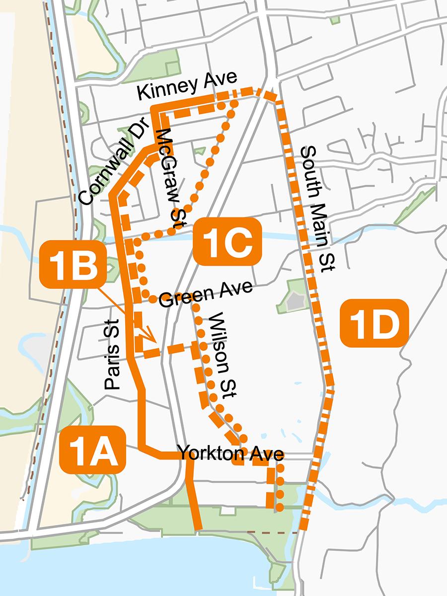
Section 1 of the Lake-to-Lake bicycle route extends from Elm Avenue at Skaha Lake to Kinney Avenue, and is 2.4–2.9 km long. The four route options are illustrated in Figure 4.
Figure 4: Section 1 route options
The preferred route is Option 1D, withprotected bicycle lanes on South Main Street where there are currently conventional bicycle lanes. As illustrated in Figure 5, parking would be maintained on the west side of the road, and the protected bicycle lanes would not impact access to adjacent properties and off-street parking. Option 1D assumes the proposed closure of Kinney Avenue to traffic between Skaha Lake Road and South Main Street, with a crossing treatment to accommodate northbound cyclists turning left.
Table 2 compares the features, advantages and disadvantages of each route option in Section 1. Option 1D is highlighted to indicate that it is the preferred option. It is a direct route that provides access to key destinations, and would have minimal impacts to parking. Option 1D has the highest level of community support, and respondents indicated a key attraction is that it is an existing bicycle route that can be improved with protected lanes. Option 1D would be the preferred option for the City to pursue in the short-term, as implementation would be relatively straightforward. The City might also want to eventually develop Option 1A as a bicycle route as well. It also has a high level of community support, and is a direct route with minimal impacts to parking. Option 1A is far enough from South Main Street and serves different destinations than Option 1D, and as a result would be a complementary option in the Lake-to-Lake route. Although it is a predominantly bicycle boulevard route on low-traffic neighbourhood streets, it incorporates a section of private road on a City easement might require discussions and arrangements with property owners before it can be designated as a bicycle route. Option 1A also incorporates a soft surface trail adjacent a future development site that would ultimately be converted to a multiuse pathway, and a new multiuse pathway on the east side of Skaha Lake Road south of Yorkton Avenue that will necessitate discussion with the owner of the adjacent property where a rock wall appears to encroach on the road right-of-way. These issues mean that implementation of Option 1A could not likely occur for a few years.
Figure 5: Protected bicycle lanes, South Main Street (Option 1D)

Table 2: Section 1 route option comparison
1A 1B 1C 1D
Route length 2.6 km 2.9 km 2.8 km 2.4 km Protected facilities 20% 35% 55% 100% Bicycle boulevard 70% 65% 45% 0% Multiuse pathway 10% 0% 0% 0% Safety • Cyclists • Pedestrians, transit users • Motorists, other road users Appeal to AAA cyclists Dimensions Directness of route Access to key destinations Parking impacts 25–45 vehs 75–160 vehs 95–160 vehs < 20 vehs Other impacts ! – – ! Cost implications – – – –Participant preference • Affected residents/businesses 9 2 4 9 • All respondents 65 13 19 76 = positive = neutral = negative vehs = vehicles ! = impacts, higher costs
Notes regarding the comparison of route options for Section 1 include: •
Safety. All route options would provide safe facilities for cyclists, including protected facilities on major roads, and crossing treatments and traffic calming measures on bicycle boulevards.
There would be no significant safety benefits or impacts for pedestrians, motorists and others.
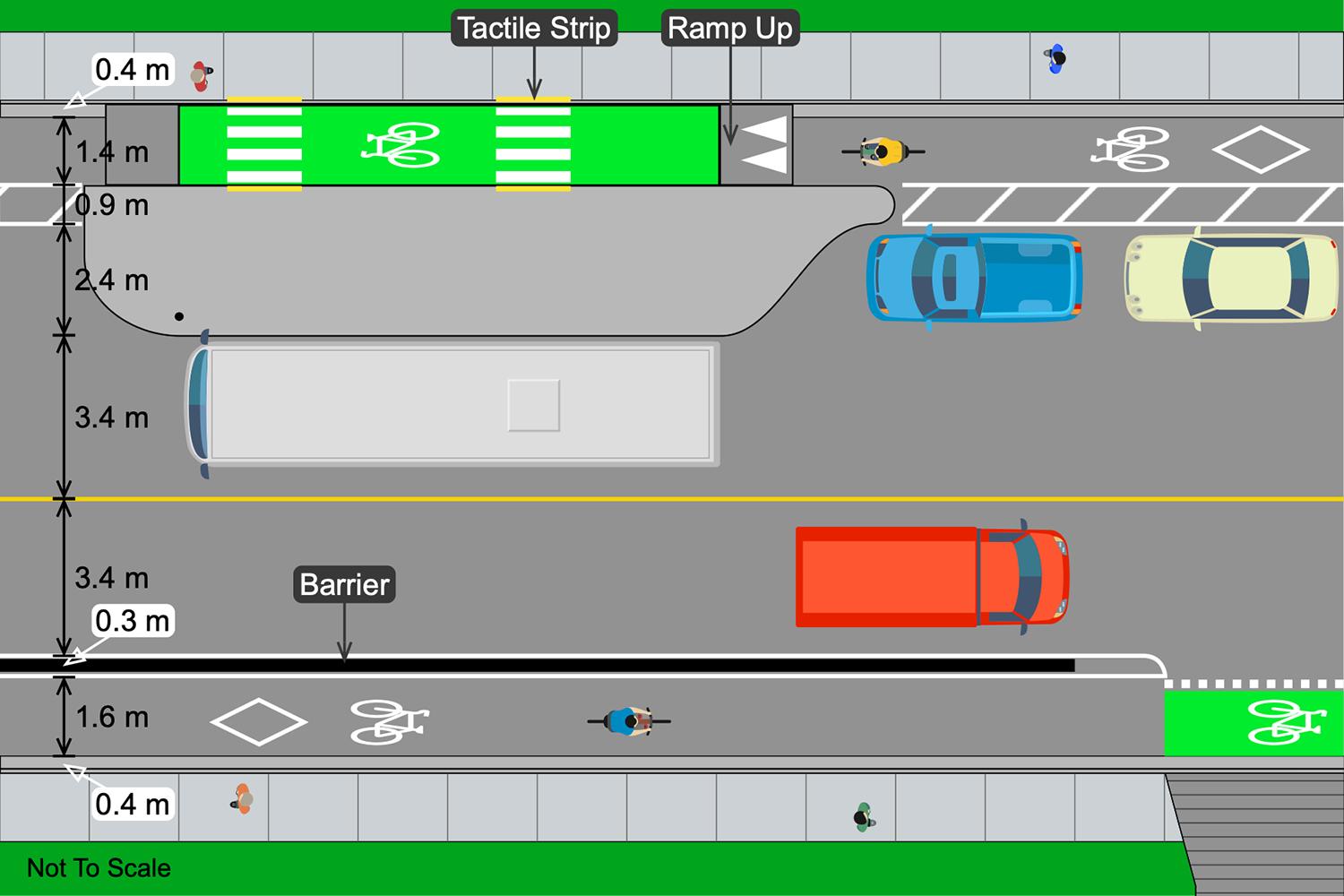
Bus stops on protected facilities would be reconfigured to prioritize pedestrians and maximize safety for transit passengers crossing the protected facility to and from the bus, as illustrated in Figure 6.
Dimensions. On Options 1B and 1C, the protected bicycle lanes or cycle tracks on Wilson Street and Yorkton Avenue would be less than minimum dimensions, as would be the traffic lanes and parking. Destinations. All route optionsprovide direct access to Cherry Lane shopping centre and Skaha Lake Park. All optionsconnect to Parkway Elementary School on Kinney Avenue, and Options 1B, 1C and 1D pass near Princess Margaret Secondary School on Green Avenue. Parking. Option 1A would eliminate parking for up to 30 vehicles on Kinney Avenue, plus eliminate parking for up to 15 vehicles on Yorkton Avenue west of Skaha Lake Road. Options 1B and 1C would eliminate significant amounts of parking on Wilson Street and Yorkton Avenue. Option 1D would eliminate a single parking space in advance of many intersections and driveways. Other impacts. Option 1A includes a section of private road on Paris Street south of Waterford Avenue, for which there is a public easement but which might require additional negotiations. On Option 1D, buses would stop in the traffic lane, which would result in delays to traffic. Cost implications. Options 1B, 1C and 1D would involve similar costs to remove parking and create protected bicycle facilities with barriers, and bus stops with floating islands. Although Option 1A would avoid most of these costs, it would include the cost of a new section of pathway on the east side of Skaha Lake Road south of Yorkton Avenue. The cost of paving the soft surface trail connecting Paris Street and Hemlock Street is assumed to be incurred by adjacent development.
Figure 6: Protected bicycle lanes and bus stops, South Main Street (Option 1D)


