6 minute read
3.4 Section 4: Fairview Road Lakeshore Drive
Section 4 extends from Scott Avenue to Lake Okanagan, through downtown Penticton, a distance of 1.6–1.8 km. The five route options are illustrated in Figure 10.
Figure 10: Route options in Section 4
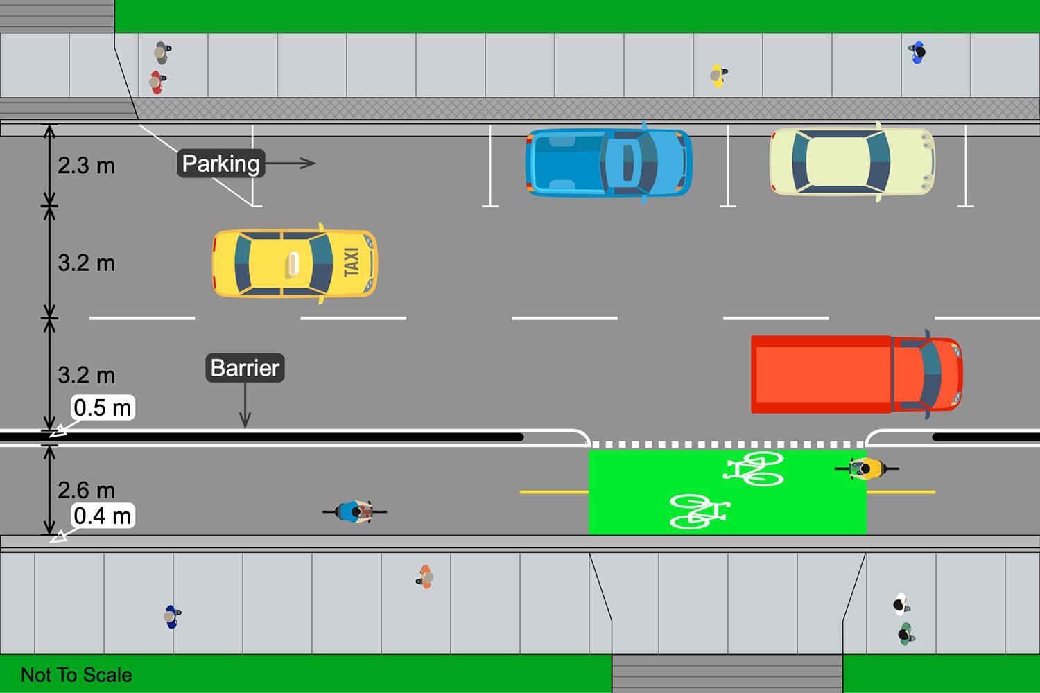
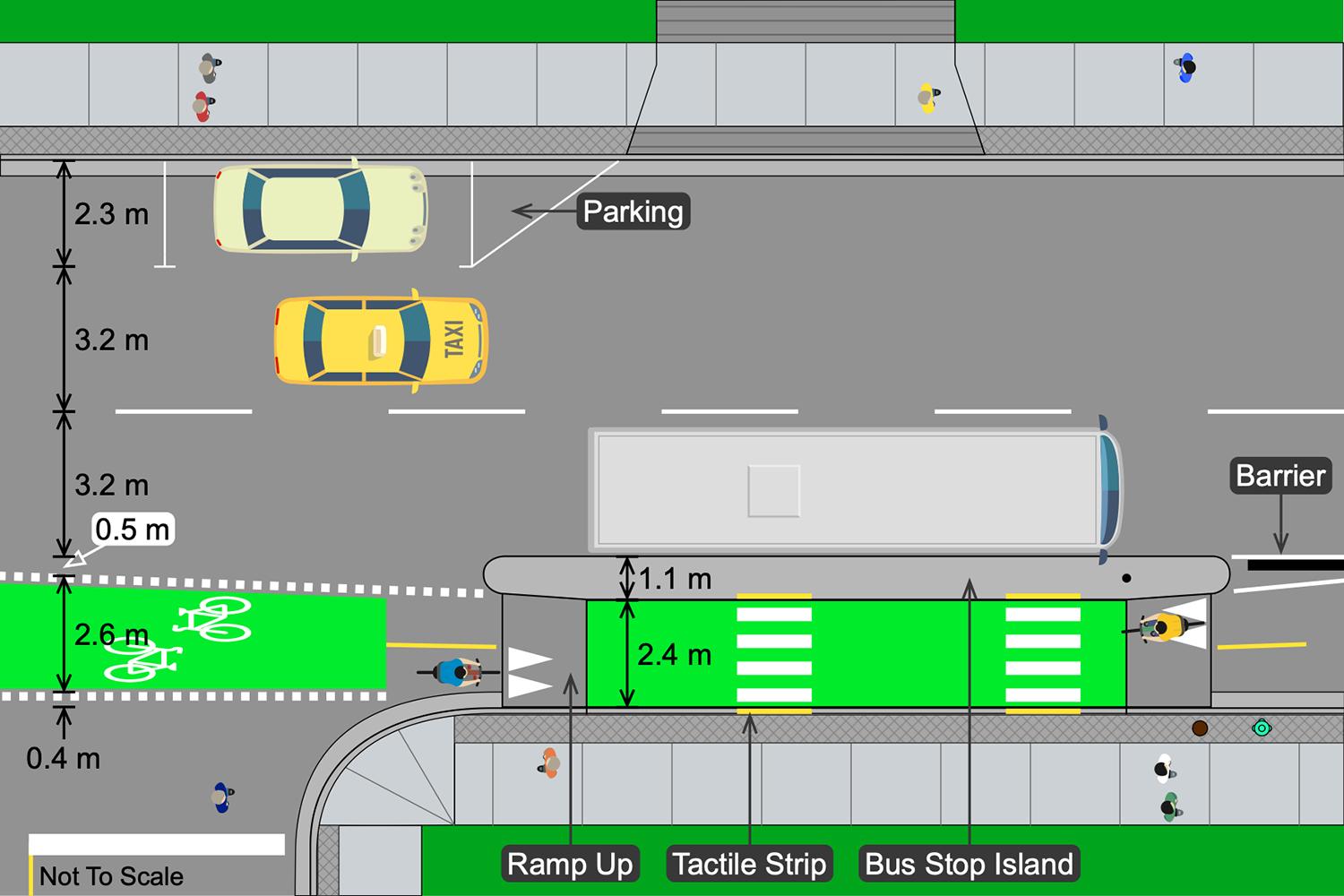
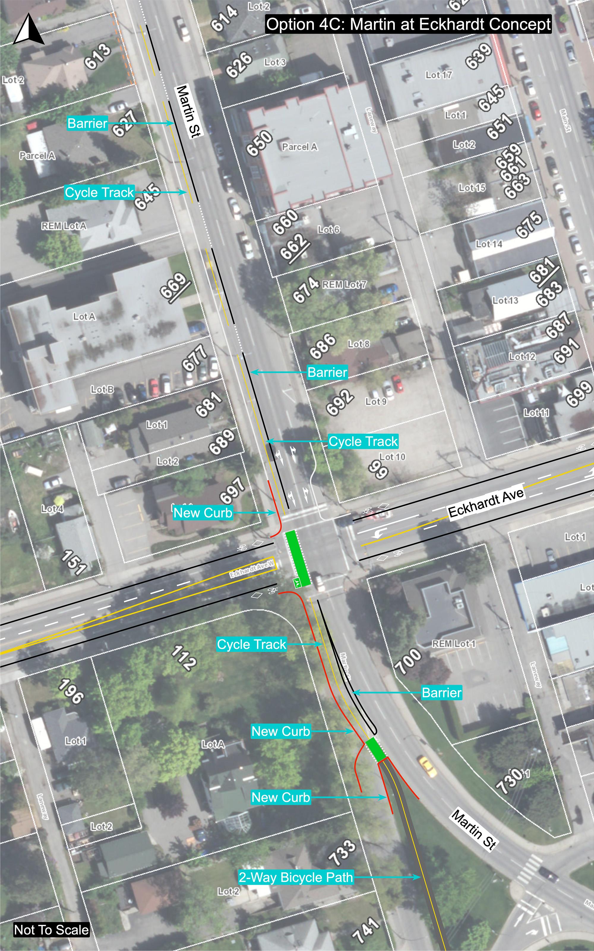
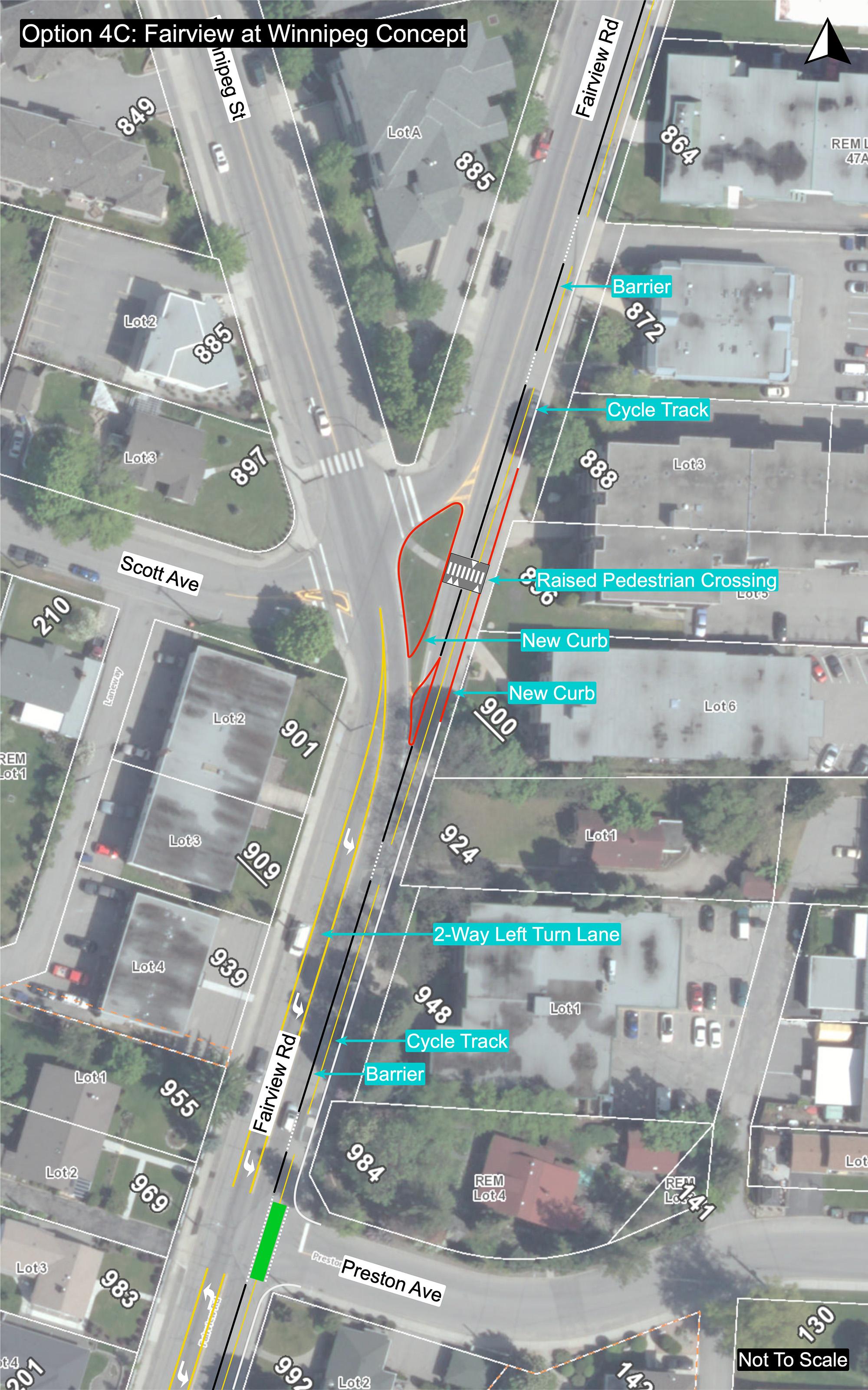
The preferred route is Option 4C, which incorporates a 2-way cycle track on the west side of Martin Street. Two traffic lanes would be maintained on Martin Street – two lanes one-way southbound south of Westminster Avenue, and one lane in each direction north of Westminster Avenue, as illustrated in Figure 11. Parking would be eliminated on the west side of the street, but would be retained on the east side of the street. The configuration of bus stops on Martin Street is illustrated in Figure 12, and conceptual illustrations of the cycle track and other improvements on Martin Street are included in the Appendix.
Table 4 compares the features, advantages and disadvantages of each route option in Section 4. Option 4C on Martin Street is highlighted as the preferred option. It is a direct route, it minimizes parking and traffic impacts, and it has the highest level of support among affected businesses and residents. Although Option 4B on Winnipeg Street had a high level of support among all respondents during engagement activities in December, subsequent engagement activities in July confirmed the preference for Option 4C on Martin Street. Option 4A was not considered an alternative as it has the same impacts on Martin Street as Option 4C, and also impacts parking and traffic operations on northbound Winnipeg Street. Key impacts on Martin Street associated with Option 4C include: •
Option 4C would impact the revitalized 200-block of Martin Street between Westminster and
Nanaimo Avenues. Implementing a cycle track would necessitate removing the parking bays and curb extensions on the west side of the road, and likely would require relocating street trees and bollards, and reconstructing the road and curbs. Removing parking would also prevent adjacent restaurants and cafes from using the sidewalk for additional seating. Options to minimize costs and impacts of the cycle track will be investigated during the detailed design phase of the project.
Implementing a cycle track would mean removing the patio in front of the Time Winery at 361 Martin Street. The patio currently extends onto the sidewalk, and a pedestrian walkway around the patio occupies three parking stalls on the west side of the road. The cycle track would displace the walkway, which would in turn require the removal of the patio from the sidewalk. Options to mitigate the impact of the cycle track on the patio will be investigated during the detailed design phase of the project.
Figure 11: Two-way cycle track, 1-way and 2-way sections of Martin Street (Option 4C)


Figure 12: Bus stop and cycle track, Martin Street (Option 4C)

Table 5: Section 4 route comparison
4A 4B 4C 4D 4E
Route length 1.6 km 1.6 km 1.6 km 1.7 km 1.8 km Protected facilities 100% 100% 100% 100% 100% Bicycle boulevard 0% 0% 0% 0% 0% Multiuse pathway 0% 0% 0% 0% 0% Safety • Cyclists • Pedestrians, transit users • Motorists, other road users Appeal to AAA cyclists Dimensions Directness of route Access to key destinations Parking impacts 195 vehs 210 vehs 90 vehs 65 vehs 130 vehs Other impacts ! ! ! ! –Cost implications ! – ! – –Participant preference Dec • Affected resident/business 4 3 4 2 0 • All respondents 38 52 26 18 26 Participant preference July • Affected resident/business 16 36 • All respondents 79 131 = positive = neutral = negative vehs = vehicles ! = impacts, higher costs
Notes regarding the comparison of route options for Section 2 include: •
Safety. All route options would provide safe facilities for cyclists. There would be no significant safety benefits or impacts for pedestrians, motorists and others. Bus stops on protected bicycle lanes or cycle tracks would be reconfigured to prioritize pedestrians and maximize safety for transit passengers crossing the protected facility to and from the bus.
Dimensions. In Option 4C, the cycle track would be less than the desired dimension (2.6 m plus a 0.4 m gutter for a total width of 3.0 m, rather than the desired width of 3.0 m excluding the gutter). In Option 4D, the combined width of the cycle track and buffer adjacent parked vehicles on Main Street would be 0.7 m less than the desired width.
Directness. Option 4D incorporates a jog at Wade Avenue which would require complex signing and routing at the Main/Wade and Ellis/Wade intersections to accommodate cyclists, pedestrians and turning vehicles. Option4E incorporates a jog at Eckhardt Avenue with similar issues, or would require a new multiuse pathway through the northwest corner of the school site.
Destinations. Option 4E runs along the edge of the downtown, rather than through the downtown as the other four routes do. Options 4D and 4E do not provide direct access to the waterfront, instead ending at the roundabout at the north end of Ellis Street.
Parking. All options would eliminate parking in order to add protected bicycle facilities. Only on the Main Street portion of Option 4D would it be possible to retain parking on both sides of the street (with the loss of one traffic lane and with significantly substandard dimensions). Other impacts. Options 4A and 4C would eliminate the parking bays, curb extensions and street trees on the west side of the revitalized 200-block section of Martin Street between Westminster and Nanaimo Avenues, and would require removing the patio in front of the Time Winery. Right turn lanes would be eliminated in Options 4A and 4B, which would result in delays to through traffic when right-turning motorists stop to wait for pedestrians. The cycle track on Main Street and Wade Avenue in Option 4D could prevent right turns by trucks and other large vehicles. On all route options, buses would stop in the traffic lane, which would result in delays to traffic, except on Martin Street and Main Street in Options 4A, 4C and 4D, where motorists would be able to pass stopped buses in the second traffic lane. Cost implications. Options 4A and 4C would require potentially costly reconstruction of the west side of the revitalized section in the 200-block of Martin Street between Westminster and Nanaimo Avenues. Otherwise, all options would involve similar costs to remove parking and create protected bicycle facilities with barriers, add bicycle signal heads and construct bus stops with floating islands.
Appendix
Option 2D: Atkinson St./Duncan Ave. Intersection Concept Option 4C: Martin St., Lakeshore Dr.–Fairview Rd. Concept


