12 minute read
Issue 1: Loss of farmland


The Clarence Valley is a relatively unique coastal LGA in that 70%, or more than 720,000 hectares of all land has a rural zone. For context, the extent of the rural landscape in the Clarence Valley is much larger than the entirety of many other LGAs on the east coast of NSW.
Correspondingly, agriculture has become a core pillar to the Clarence Valley economy and the largest of its kind across the region. In 2019/2020, $216 million was exported in agriculture, forestry and fishing in the Clarence Valley alone – including close to a four-fold increase in agricultural exports between 2001/2000 and 2019/202020 .
The Clarence Valley Regional Economic Development Strategy 2018 – 2022 further highlights this economic importance, pointing out that arable land in the Clarence Valley realises substantial yields for its communities. Ensuring the strength of the agriculture industry is continued over the next 20 years is imperative, and key to this is addressing the loss of farmland.
The loss of farmland typically occurs incrementally. This loss is difficult to quantify and the need to track this is a key recommendation of the recent Right to Farm Policy Review and DPI’s Agricultural Land Use Planning Strategy: Options Paper and a recommendation of the NSW Agricultural Commissioner’s Improving the Prospects for Agriculture and Regional Australia in the NSW Planning System21 report.
20 Sourced from https://economy.id.com.au/clarence-valley/exports-by-industry?sEndYear=2001 accessed 17 November 2021 Key aspects of this issue include:
o Defining important agricultural land o Avoiding urban encroachment o Rural lifestylers not utilising land for agricultural purposes o Farms / industries no longer being viable o Changing climatic conditions
While some of these issues are more prevalent in the Clarence Valley than others, the following sections provided an overview of each.
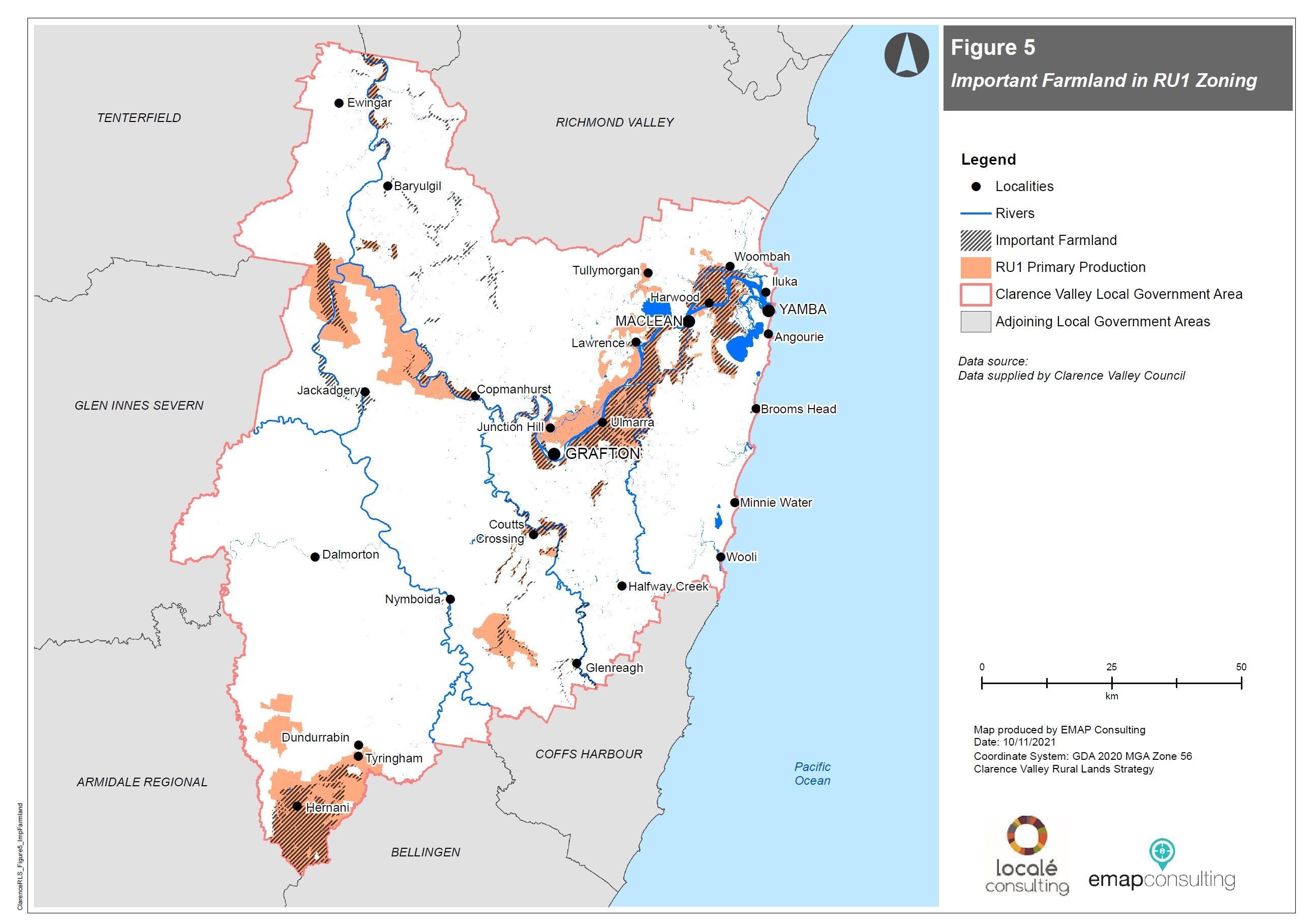
1.1 Important agricultural land mapping
DPI has previously undertaken Far North Coast Farmland Mapping across the Northern Rivers in 2005, and this mapping was more recently confirmed in 2020 without change in the Clarence Valley area after being recognised as ‘best in State’ example of regional agricultural mapping22. This mapping has been integrated into the NCRP 2036 and part of the strategic planning process for many years, providing both State and local government with a recognised basis to identify and value important agricultural land and integrate it into land use planning.
The value of the mapping is further identified within the 2021 NSW Agricultural Commissioner’s report, stating “The Far North Coast and Mid-North Coast Important Farmland Map is a good example of how a
21 Sourced from: https://www.dpi.nsw.gov.au/__data/assets/pdf_file/0019/1361611/Improving-the-
Prospects-for-Agriculture-and-Regional-Australia-in-NSW_NSW-Ag-Commissioner.pdf 10 November 2021 22 Pers Comm – Selina Stillman 10 June 2021
regional scale map can reduce the rate of rezoning of agricultural land” and as a consequence of the mapping “The North Coast converted less agricultural land despite having a dwelling target 25 per cent higher than the Illawarra Shoalhaven region.”
The extent of the existing mapping, as based on the NCRP 2036, is presented in Figure 12 (see page 38) alongside the existing extent of the RU1 Primary Production zone.
Importantly, land identified as within the Far North Coast Farmland Mapping represents those lands that are of the greatest agricultural value for soil-based agriculture, and typically cannot be replaced elsewhere. A key mechanism for the protection of Far North Coast Farmland Mapping is through the application of zones that stipulate prohibited and permitted uses.
A comparative analysis between the location of Councils rural zones and the location of the Far North Coast Farmland Mapping was conducted. This found that 82% of all Far North Coast Farmland Mapped areas is located within Council’s RU1 Primary Production zone, with a further 10% located within the RU2 Rural Landscape zone. This indicates a positive correlation between the RU1 zone and Far North Coast Farmland Mapping.
Conversely, only 48% of RU1 land contains Far North Coast Farmland Mapping, suggesting that there may be areas of RU1 zoned land that could be moved into the RU2 or another zones. Review and adjustment of the RU1 and RU2 zones in areas where viable land size within the Far North Coast Farmland Mapping can be achieved is recommended. Examples of potential changes include (see corresponding plans in Figure 11 overleaf):
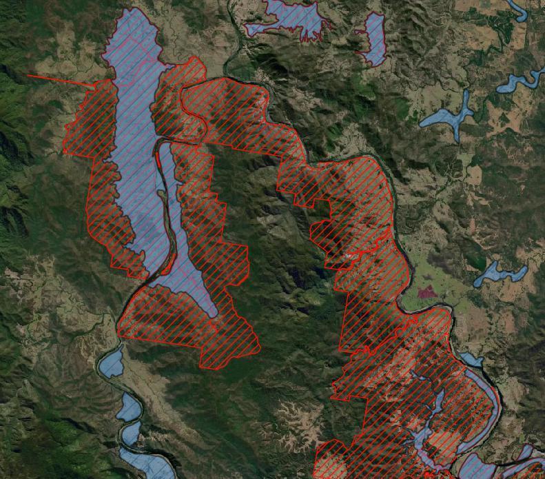
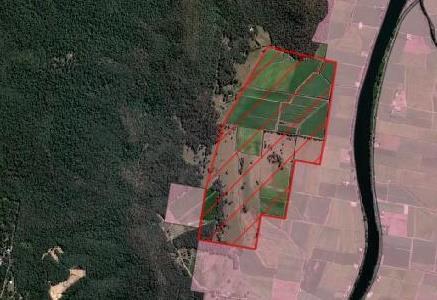
o inclusion of sugarcane (or other cropped land with applicable attributes) within the RU1 zone (e.g. around Woodford Island –
Image 1) o correlation of farmland mapping to the RU1 zone where viable to farm sizes / existing uses (e.g. around Jackadgery – Image 2 - noting that land immediately adjoining waterways would not be recommended for change to RU1) o RU1 land outside the existing farmland mapping (as per the
NCRP 2036) that is only used for grazing, could be rezoned to
RU2 (and potentially C3 in steep sloping country) (e.g. around the junction of the Mann and Clarence Rivers – Image 3)
It is noted that in conjunction with the release of the NSW Agricultural Commissioner’s report (July 2021), a draft State Significant Agricultural Land Map has been developed and exhibited in late 2021. The exhibited mapping is far more expansive that the existing regional Plan important farmland mapping. The total area of land is almost 200,000 hectares, or more than a 300% increase over the existing mapping. The exhibited draft mapping also covers large expanses of native vegetation which appear to be counter-intuitive to being significant farmland and is not consistent with the recommendations of this Report. Review of the mapping indicates:
o 61,600 hectares of land is covered by both the draft State
Significant Agricultural Land Map and the previously identified
Far North Coast Farmland Mapping
o Almost 5,000 hectares of land mapped as Far North Coast
Farmland is not included within the draft State Significant
Agricultural Land Map o More than 137,000 hectares of land is included in the draft
State Significant Agricultural Land Map but not in the Far
North Coast Farmland Mapping.
In addition, 62% of the draft State Significant Agricultural Land Map is included in the RU2 zoned land, 36% is within the RU1 zone and 2% or just over 4,000ha is within the C3 Environmental Management zone.
Given this mapping is in draft form, and its extents are of debate, this Background Paper assumes the use of the existing adopted mapping only.
1 3
RU2 zoned sugarcane / other cropped land contiguous with RU1 land adjoining. Consider for inclusion in RU1. Example located at Woodford Island / South Arm.
2
Area of mapped farmland utilised for agriculture currently zoned C3. Consider for inclusion in RU1 or RU2 zone. Example located at Jackadgery. RU1 zoned land surrounding mapped farmland (in blue). Broad grazing land may be considered for inclusion in RU2. Example located near the junction of the Clarence and Mann Rivers.
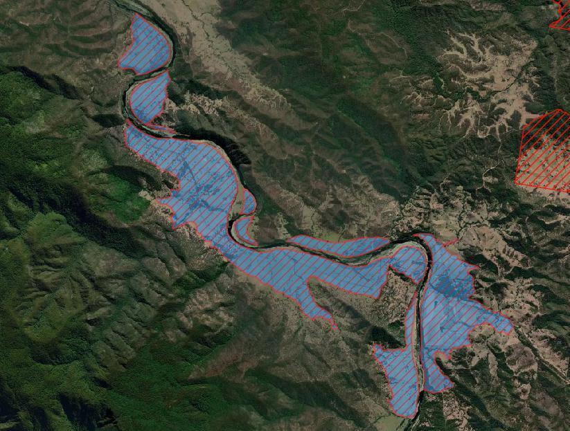
LEGEND
Far North Coast Farmland Mapping area
RU1 Primary Production area
Indicative area of potential rezoning
Figure 11: Examples areas to consider rezoning
NOTE: ALL EXAMPLES ARE INDICATIVE ONLY AND SUBJECT TO DETAILED INVESTIGATIONS
Figure 12: INSERT IMPORTANT AGRICULTURAL FARMLAND MAP
Figure 5 12: Farmland mapping
extents
1.2 Rural lifestylers
‘Rural Lifestylers’ is a term referring to those individuals or families who buy rural land with little to no intent to use the land for commercial agricultural purposes (also referred to as people seeking a ‘tree change’). Many rural lifestylers buy rural land for the visual amenity values, peace and quiet, and/or a sense of space. This ‘rural lifestyle’ move has been occurring for some time, whilst being spurred on by the Covid-19 pandemic23 , and partly due to the ability of many individuals to work from home allowing them to live in rural or remote locations.
A potential unintended consequence is the loss of farmland no longer being used for these purposes. Whilst the land may still be used for some household farming, the loss of agricultural productivity (and land use conflict – see Issue 2) can gradually impact on overall productivity over the longer-term.
This situation also has ‘side effects’ of lifestylers not having the knowledge and tools to maintain or improve the land. This can result in increases in weeds and other poor land management practices, risking bio-security and other impacts that further degrade agricultural production or environmental outcomes24 .
Whilst the extent of treechange pressures may reduce postpandemic25, there remains a continued need for education, co-
23 See for example https://www.abc.net.au/news/2021-06-25/covid-regional-australia-populationhousing-services/100235562 and http://www.regionalaustralia.org.au/home/regional-moversindex/ - accessed 17 November 2021 24 See for example Biosecurity and Small Landholders in Peri-Urban Australia – Bureau of Rural
Sciences 2007 ordination and engagement with these types of (typically) small landholders to increase the overall productivity of agricultural lands.
1.3 Farm / industry viability
Small but consistent loss of agricultural land impacts not only individual and neighbouring farmers but also broader industries. Some industries in the Clarence Valley rely on having a critical mass of producers who collaborate together through key infrastructure to ensure ongoing viability.
This is especially evident in the sugarcane industry where the main concern relating to the loss of farmland relates to the critical mass needed to sustain the existing mill (servicing the local area) and refinery (servicing the broader region) that are located at Harwood (i.e. within the Clarence Valley). The industry reports that much larger farms are now required to sustain returns from smaller farms of 10 years ago, exacerbating the potential impacts from even small losses26 . If the operation of key infrastructure is no longer viable, the entire industry in NSW is likely to struggle.
That said, Sunshine Sugar have indicated that the sugarcane industry is now the biggest contributor to the Clarence Valley agri-food economy, with an estimated value of around $90 million. The Harwood Sugar Mill services around 10,500 hectares of production and more than 1,000 people are employed through the NSW production area (all
25 See for example - https://www.abc.net.au/news/2021-06-25/covid-regional-australia-populationhousing-services/100235562 - accessed 17 November 2021 26 Pers Comm – Clarence Canegrowers Association, 17 June 2021
utilising the Harwood refinery). Ensuring that this long-term viability therefore remains important.
Acknowledging the NSW Agricultural Commissioners comments that “The State and councils have no oversight of how much agricultural land is available and at what rate it is being converted to other land uses”27 , consultation with agencies and industries in development of this Paper observed that the incremental loss of farmland has not been as strongly felt in the Clarence Valley as in surrounding LGAs. While this presents the opportunity to address this issue in the Strategy before it comes acute, lifestyle trends only likely to increase in the longer-term and careful planning is needed now to avoid loss of farmland over this period.
1.4 Climate change
Council declared a ‘Climate Emergency’ in 2019. This followed previous recognition of the issue through the development of the Clarence Valley Climate Change Policy and associated sea level rise benchmarks. These recognise that climate change will impact both the current and future generations of the Clarence Valley28 .
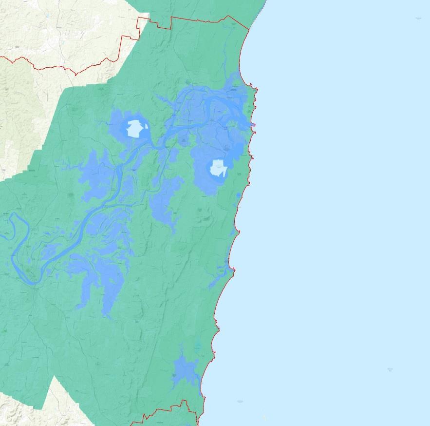
Climate change is a foundational concern that underpins many of the issues on rural lands, and in particular the impacts of sea level rise (and associated salinity) across large portions of identified important farmland (refer Figure 13 which represents the low impact scenario only29). This has the potential to lead to a loss of productive
27 Improving the Prospects for Agriculture and Regional Australia in the NSW Planning System (2021) –
NSW Agricultural Commissioner 28 See https://www.clarence.nsw.gov.au/Council/Governance-and-transparency/Policies/Climatechange - accessed 2 November 2021 agricultural land or need to modify the types of commodities that are being produced, as well as potential disruption to transportation.
MACLEAN YAMBA
GRAFTON
LOW SCENARIO
Figure 13: Predicted inundation from sea level rise - 2100
29 Sourced from https://coastadapt.com.au/sea-level-rise-information-all-australian-coastalcouncils#NSW_CLARENCE_VALLEY – accessed 17 November 2021
While sea level rise will occur incrementally, and the impact may not be realised over the life of this Strategy, recognising farmland will ultimately be impacted and/or lost as a result is important to more short-term actions.
Within this context, there are also a number of related activities and actions that are associated with climate action, government policies associated with Net Zero by 2050, and potential for rural land holders. For example, the 2021 Federal Government Long-Term Emissions Reduction Plan - A whole-of-economy Plan to achieve net zero emissions by 2050, recognises the high potential for improved management of Australia’s crop and grazing lands, potentially securing 10’s of millions of tonnes of carbon per annum. This provides secondary income sources whilst developing more sustainable agricultural practices –which is further discussed under Issue 5: Sustainable land management.
RELATED RURAL LANDS STRATEGY RECOMMENDATIONS
Note: the recommendation numbers relate to those presented in the Rural Land Strategy document for ease of reference.
Facilitate effective land use planning for rural areas
Recommendation 1: Review the applicability of RU1 and RU2 zones In context of the Far North Coast Farmland Mapping, and other land with verified high quality agricultural attributes, Council will review how the RU1 and RU2 is applied. This would delineate that the RU1 –Primary Production zone will primarily protect and reserve land for agricultural productivity, while the RU2 – Rural Landscape zone will enable a more diverse range of uses and activities suitable to rural areas. Recommendation 5: Review subdivision controls to facilitate agricultural production whilst minimising the establishment of new dwelling entitlements in the RU1 zone To ensure farm and industry viability, some agricultural industries require large areas of agricultural land that does not necessitate the need for an additional dwelling entitlement. This would also reduce the issue of 'rural lifestylers’ buying productive agricultural land as the intent of this control is to allow rural subdivision that would not be accompanied by a dwelling entitlement.
Elevate the importance of rural lands within Council and the community
Recommendation 11: Undertake forward planning for impacts of climate change on rural lands With projected sea level rise and other expected climate change related impacts, currently productive agricultural land will undoubtedly be lost. Understanding the extent of this impact and preparing accordingly is critical for rural land holders and broader industry viability.
Engage with government and industry to leverage support
Recommendation 15: Continue to review, collaborate and, where require, maintain consistency with evolving State polices
State agencies are currently giving considerable attention to establishing policies and directions around reducing the loss of agricultural land. Ensuring Council is continually aware of, responding to and engaging with State policies and directions may assist in the retention of key farmland across the longer-term.


