


Mapdata:Google©2022,MaxarTechnologies
Overview
ODU5islocatedbetweenMillRytheJuniorSchoolandSalternsLane.This frontagehasbeensplitintothreesubunits(ODU5A,5Band5C)toreflectthe changesinlanduseandriskwithinthisunit.ODU5AincorporatestheMill RytheHolidayVillageborderedbyagriculturalland.ODU5Bispredominately agriculturalfarmlandalongsideTournerburyGolfCourse.TothesouthODU5C stretchesfromTournerburyWoodsEstatetoSalternsLaneandincludes TournerburyWoodsEstate,andadhocresidentialandcommercialproperties. Defences Defencesconsistofavarietyofembankmentandrevetmentstructures.InODU 5A,aroundtheMillRytheHolidayVillage,defencesareprivatelyownedbut maintainedbytheEnvironmentAgencyandhaveresiduallivesofbetween10 and15years.Elsewheretheresiduallivesoftheseprivatelyownedand maintaineddefencesarelessthan10yearsandinlocalisedareasarealready failing.TheexceptionbeingtherockrevetmentsouthofTounerburyGolf Coursewhichhasaresiduallifeofbetween15and20years.


Environment
Thefrontageiscoveredbysignificantenvironmentaldesignations,bothon landandintheHarbourandfallswithintheChichesterHarbourNational Landscape.AgriculturallandinODU5BandTournerburyWoodsEstatein ODU5CaredesignatedasSSSI,RamsarandSPA,whilethefrontingintertidal areasareSSSI,Ramsar,SPAandSAC.Anareaofformercoastallandfillisalso locatedinthefarsouthoftheunit,andTournerBuryScheduledMonument, theremainsofanIronAgeplateauhillfort,alsotothesouth,isatincreasing tidalfloodriskovertime.
ShorelineManagementPlanPolicy
HoldtheLine,butnopublicfundingavailableforprivatedefencesforthe next100years.
Risk
Riskhereisfromtidalflooding,wherethefloodextentreachesasfarasMillRythevillage.Here,over200 propertiesaswellasMillRytheJuniorSchoolareattidalfloodriskoverthenext100years,withoutdefencesin place.AlthoughtheGolfCourseandassociatedassetsareonhigherland,sonotatrisk,tidalfloodriskissignificant inthelowerlyingareas.IncontrastODU5Cisonhigherland,sofloodanderosionrisktoadhocpropertiesand TournerburyWoodsEstateislow.
Themapsbelowshowthemodelledextentanddepthsofanextremetidalfloodevent(1in200year,0.5%annual probability),withoutanydefences,todayandin100years,allowingforsealevelrise.


OverallStrategicOption Sustain1.33%AEPwith managedrealignment


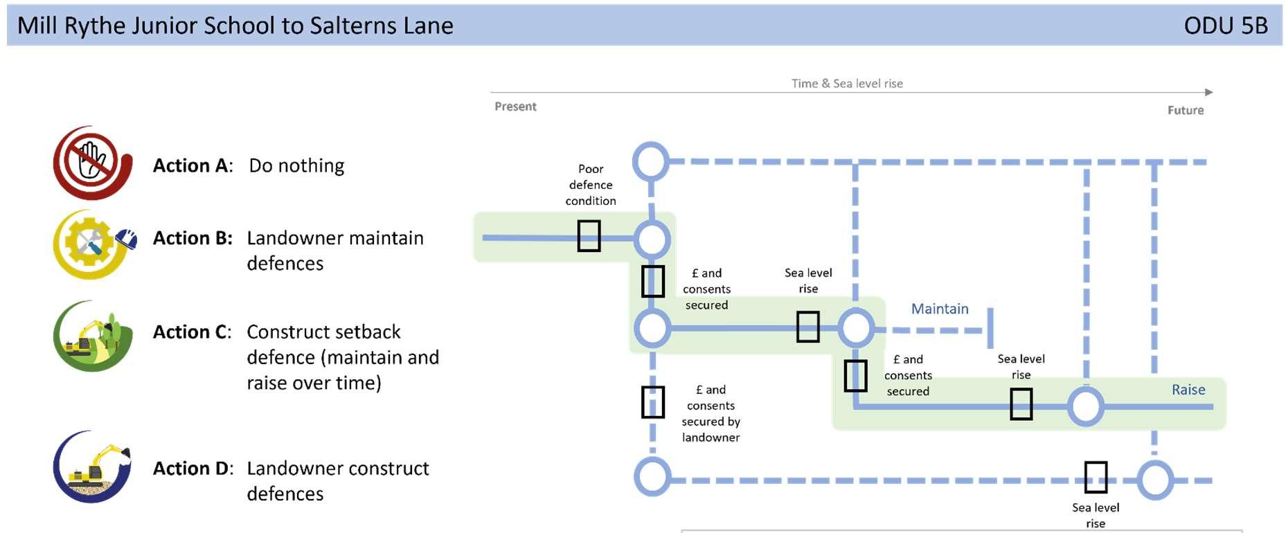


defencesalongthecentralsectiontoallowforhabitatcreationand naturalevolutionoftheshoreline(ODU5B),andinthesouth,prevent formerlandfillfromeroding/leachingintotheHarbour(ODU5C).
Notonlydoesthisprovidefloodriskprotectiontopropertiesandthe schoolinthenorth,butitalsoprotectsformercoastallandfillwhilst makingspacefornaturewhereviabletodoso,tomeettheneedsof ChichesterHarbourtocreateamosaicofnewhabitats.Thiswillrequire constructionofnewmoresustainabledefencesinphasesandablended managementapproachinclosecollaborationwithallpartners.Ifthe landfillisfoundnottobeharmfultotheenvironment,then opportunitiestosetbackdefencesshouldbeinvestigatedhere.
NextSteps
Anadditionalstudyisalreadyunderwaytounderstandthecomplexitiesof theTournerburyFarm(ODU5B)siteinmoredetailtolookatpotential optionsandtofindasolutionthatwillbalancetheneedsofallparties.A habitatrestorationschemeforTournerburyhasbeenproposedinthe Strategy’sshorttermactionplantofollowthestudy.Subjecttosecuring funding,thiswillstartwithafeasibilitystudytoappraiseappropriatecoastal managementoptionsandalignmentswhichprovidetheleastdamaging impactonthenaturalenvironment.