
Danube´s Archaeological Routes

Danube´s Archaeological routes - Cultural route proposals for Stone Age, Neolithic, Copper Age, Bronze Age and Barbarian (Late Antiquity and Early Middle Age) Periods
Deliverable D.T3.2.2
Published by: University of Vienna for the Danube´s Archaeological eLandscapes partners
Editor: Martin Fera
Contributions: Aenna Linzbauer, Marko Mele, Porin Šćukanec Rezniček, Marta Rakvin, Jacqueline Balen, and all project partners in the data collection

Online: Vienna, 2022
ISBN-number: -
The Danube´s Archaeological eLandscapes project is implemented under the Danube Transnational Programme (DTP), funded by the European Regional Development Fund (ERDF) and co-funded by Hungary, Romania and Bulgaria. ERDF Contribution: 2118635.56, EUR, IPA Contribution: 21335 EUR, DTP 641.
Table of contents
1 Executive Summary (Martin Fera) ................................................................................................... 4
2 What are Cultural Routes and how to create them (Porin Šćukanec Rezniček, Marta Rakvin, Jacqueline Balen) 6
2.1 How to create a cultural route? 6 3 Danube´s Archaeological eLandscapes (Martin Fera) 9 3.1 Project facts 9 3.2 Activity A.T3.2 – Archaeological routes of the Danube region ..............................11
3.2.1 Data model and data collection ......................................................................................... 12 3.2.2 Physical implementation and web-frontend ....................................................... 14 3.2.3 Data analysis 16 4 Results – Online presentation https://dael-routes.eu (Martin Fera) 19
4.1 Stone Age Route: Hunters and Gatherers 20 4.2 Neolithic Route: First Farmers and Early Herders 21 4.3 Copper Age Route: The Dawn of Metallurgy 22 4.4 Bronze Age Route: Miners and Traders............................................................................. 23 4.5 Barbarians Route: The Fall of Rome and the Rise of Realms ............................. 24 5 Recommendations (Martin Fera) ................................................................................................... 25
1 Executive Summary (Martin Fera)
The Interreg project Danube´s Archaeological eLandscapes (07-2020 to 12-2022) aimed to support one of the largest networks of major institutions with archaeological collections and knowledge in the Danube Region. The project´s major goal was to make archaeological landscapes of the Danube region more visible and thereby more attractive for its integration into sustainable cultural tourism, regionally, nationally and internationally.
Following the Iron Age Danube Route - which became a certified Cultural Route of the Council of Europe in May 2021 - the international partners in the project Danube s Archaeological eLandscapes identified archaeological heritage elements illustrative of common European memory, history and heritage and presented them as proposals for 5 thematic cultural routes in a web database. The proposals cover:
• Palaeolithic (Stone Age route)
• Neolithic (Neolithic route)
• Copper Age (Copper Age Route)
• Bronze Age (Bronze Age route)
• Late Antiquity and Early Medieval Period (Barbarians route)
The results are presented on the webpage https://www.dael-routes.eu/ where more information can be accessed. The database allows to browse through the sites and landscapes representing a thematic selection of archaeological highlights, telling stories of important periods of the European past.
Within this project the first two steps of a five-step process of the creation of new cultural routes have been carried out: the creation of a theme and the identification of heritage elements by the experts of the partner countries involved. Following steps were started by organising workshops and presenting the proposals to stakeholders, however, clearly further measures are recommended to continue the development process and bring the proposals to strong networks who can carry out the next steps towards attractive new archaeological COE Cultural Routes.
2 What are Cultural Routes and how to create them (Porin
Šćukanec Rezniček, Marta Rakvin, Jacqueline Balen)A cultural route is a cultural, educational and tourism project of cooperation between several different partners with the aim of developing and promoting itineraries or a network of itineraries based on historical routes, a cultural concept or phenomenon that transcends local borders and contributes to the understanding and respect of common values.
Cultural Routes present a form of time travel, whereby the passenger transcends both time and space of the various countries and cultures of present-day Europe. In such instances, cultural heritage is not only kept alive but is shared across borders for all interested stakeholders. Curious passengers are brought together and invited to explore inter-connected networks of heritage, places and history, thereby bringing to life the core values of the Council of Europe: human rights, intercultural dialogue, mutual exchanges across borders and cultural diversity. How was/is this envisaged? Each cultural route provides a number of activities open to all ages and social groups; be it educational, for recreation and relaxation, or somewhere in between. In order to achieve such conditions, routes must be developed and attuned in a sustainable and responsible manner, offering local products and everything else to suit the traveler’s tastes. A cultural route must be viewed through the lenses of both culture and tourism, with all the required traits, information, content, accommodation or catering services. If a question arises of how is this possible, it is sufficient to take a look at the broad range of topics and themes that made it into cultural routes: from Vikings to Phoenicians, Mozart or Saint Martin, olive trees, cemeteries, prehistoric rock art, the Habsburgs, fairy tales, the Iron Age in the Danube region, and many more.
2.1
How to create a cultural route?
Fortunately, developing a cultural route and interpreting cultural heritage has nowadays become a relatively straightforward process. Experts have often come together, offering advice, guidelines or frameworks for potential future cultural route enthusiasts and professionals. In order to create a new route, one has only to look beyond new topics, landscapes, religious themes, gastronomical, musical or literary features which have already been covered. The requisite high standards for cultural route certification provides not only various topics, but also guarantees excellence of the highest order for the five main priority fields of action: cooperation in research and development; enhancement of memory, history and European heritage; cultural and educational exchanges for young Europeans; contemporary cultural and artistic practice; cultural tourism and sustainable cultural development. The result is a phenomenal mixture of European cultures, stretching across borders, encouraging the development of lesser-known destinations, facilitating synergies between local, regional and/or national stakeholders for all social and economic beneficiaries in a sustainable and progressive form of tourism management.
But how does one create a cultural route? Nowadays there are several key features to the whole process. Firstly, the creator(s) must think of the purpose of the route, answering the question “why?” and focusing first on the stages of the development, rather than the end products. The priority thematic base should be established within the context of European countries, history and common values,
defined by heritage that binds and balances other similar topics. Additionally, it needs to be grounded within and conducted according to theoretical and practical interdisciplinary research. Furthermore, the theme needs to be unique and specific enough, with several key cultural, national focal points, interconnected with offers from the catering industry. Reasons might also include a new meaning for local communities, potential stakeholders and partners, fostering local regional identity, knowledge dissemination and consolidation, developing a new tourist offer in line with the topic, ensuring sustainability or creating value.
Secondly, creators of a route need to consider the scope of the entire project. Will the route pertain to a local or broader level (regional, national, supranational)? Will it satisfy conditions for each level, bearing in mind various concepts and their differences such as routes, tours, itineraries, cultural routes etc.? Furthermore, a clear management structure needs to be established from the very beginning (legal ownership framework, technology needs, administration, etc.). For all of these, creators need to consider which experts to include from the very beginning; institutions (such as galleries, museums, cultural centres, etc.), organizations, companies, or other persons of interest, in order to benefit the process as a whole.
After laying the groundwork, a bestselling story can be developed, all the while bearing in mind the need to connect specific target groups/audiences, offer unique and interesting experiences and have a meaningful local influence. These foundations will take several years to establish, and can involve numerous trials and errors in order to explore the best possible solutions for particular interests or groups. It should encompass a multitude of things: different languages, signs, interpretations, info points, local or educational guides, hospitality services, etc., within a common, encompassing visual identity. One example could be the establishment of a heritage link with a community who may have shown little interest (or even hostile views) towards cultural heritage, such as is sometimes the case with farming communities who must contend with upstanding monuments when ploughing their fields. It is up to the creators and route management to turn this view around and demonstrate the benefits of the routes and its content to the local community. The creators must facilitate a form of motivation for the stakeholder. A proper research campaign undertaken beforehand, studying and processing the market, will prove invaluable in such environments. One example is a large museum and a local artisan, who, at first glance, might not see eye to eye. However, by developing a plan whereby the museum presents the cultural heritage from the area, and in doing so sells the artisan’s products in its shop, an understanding between the two stakeholders can be established. This way, the artisan not only benefits from the sale of their work, but can also offer unique tours from his or her own point of view on what inspired him/her from the museum’s collections or local cultural heritage. Thus, a sustainable, revolving cycle of cooperation is established between the stakeholders.
In theory, this process seems fairly straightforward, but how does it translate into practice? There are a number of examples of good practice currently being employed by one of the existing 48 Cultural Routes, as well as other similar projects. In the last couple of years, for pandemic related reasons and the
advancement of technology, the focus has turned to digital practice. 3D models, visualizations for VR glasses or touchscreen applications, have proven to be especially efficient and attractive to audiences, and these approaches enrich cultural heritage in novel and popular ways. As people spend increasing amounts of their time on electronic devices, this shift towards digital technology has been a logical one in order to offer content and increased value from some of the leading heritage institutions. It also exemplifies how modern technology can be used in such an environment. Others might also opt for a digital solution to enrich other, extant, experiences. For example, a digital bicycle map or treasure hunt might be created for a particular region, which connects and guides visitors through various heritage points. In this sense, however, the actual site and leisure activity are the main foci. Additionally, such examples could involve the setting up of info panels providing not only necessary information, but also offering additional information via QR codes or AR technology. Moreover, the usage of such digital tools enables professionals to gather data and feedback based directly on user experiences. These inputs can provide a creative insight and change the direction of how certain parts of the route are presented.
In order to provide further assistance to future route developers, we offer some short guidelines, experience and suggestion to start off. For more comprehensive and detailed guidelines throughout the process the Action Plan of the Danube’s Archaeological eLandscapes project (https://www.interreg-danube.eu/approvedprojects/danube-s-archaeological-elandscapes)
Walkthrough activities expected in creating a cultural route:
1. Define a theme 2. Identify heritage 3. Create a network 4. Coordinate common activities 5. Ensure a common visibility Theme is everything! How to enhance it for a Cultural Route?
• Build a personal story around the theme – with detailed scientific data
• Interpretation – use research and translation of scientific data into storytelling for written, oral, interactive, virtual … interpretation
• Identify USP (Unique Selling Proposition) features, compatibility models, key historic links – with other locations for packaging
• Presentation – define presentation standards & identity standards
Finally, always bear in mind, cultural routes should be sustainable! Here are only a few suggestions:
• link between inhabitants and tourists
• link between tourism and values
• link - connecting the partners and destinations
• local and European promotion
• new benefit for local communities
3 Danube´s Archaeological eLandscapes (Martin Fera)
The rich and culturally diverse archaeological record of the Danube region is an integral part of our shared cultural heritage. It offers great touristic potential, but constantly faces the challenge of being largely unrecognized. Innovative digital technologies can help visualize archaeological heritage in completely new ways, and make it accessible for the public in attractive mediums. By incorporating Virtual Reality (VR) and Augmented Reality (AR) technologies, museum visitors are encouraged to get to know the rich archaeological heritage not only in the museum exhibitions, but also in the context of the landscapes from which they originate.
The primary objective of the project is to make the archaeological landscapes of the Danube region more visible and attractive regionally, nationally, and internationally, via new thematic routes, thus promoting sustainable cultural tourism.
3.1 Project facts
PROJECT ACRONYM: Danube´s Archaeological eLandscapes
PROJECT NAME: Virtual archaeological landscapes of the Danube region
DURATION: 01. 07. 2020 - 31. 12. 2022
BUDGET IN EUROS –
OVERALL: 2517612.44, ERDF CONTRIBUTION: 2118635.56, IPA CONTRIBUTION: 21335, ENI CONTRIBUTION: 0
CALL NUMBER: Call 3
PRIORITY: Environment and culture responsible Danube region
SPECIFIC OBJECTIVE: Foster sustainable use of natural and cultural heritage and resources
WEBSITE: www.interreg-danube.eu/approved-projects/danube-s-archaeologicalelandscapes
LEAD PARTNER
• ERDF LP Universalmuseum Joanneum (AT)
PROJECT PARTNERS
• ERDF PP1 University of Vienna (AT)
• ERDF PP2 National Museum of Slovenia (SI)
• ERDF PP3 Institute for the Protection of Cultural Heritage of Slovenia (SI)
• ERDF PP4 Hungarian National Museum (HU)
• ERDF PP5 National History Museum of Romania (RO)
• ERDF PP7 Archaeological museum in Zagreb (HR)
• ERDF PP8 State Office for Cultural Heritage Baden-Württemberg (DE)
• ERDF PP9 Rousse Regional Museum of History (BU)
• ERDF PP10 Technical University of Kosice (SK)
ASSOCIATED PROJECT PARTNERS
• AP Federal Monuments Agency of Austria (AT)
• AP Institute for Antropological Research, Zagreb (HR)
• AP Donja Voća Municipality (HR)
• AP Center for Prehistoric Research (HR)
• AP Public Institute for the Management of Heritage and Tourism Pivka, Park of Military History (SI)
• AP Council of village Nemesvámos (HU)
• AP Local government of Vértesszőlős (HU)
• AP Veszprem-Balaton 2023 Plc. (HU)
• AP Center for Studies in Cultural Development (RS)
• AP University of Graz - Centre for Information Modelling - Austrian Centre for Digital Humanities (AT)
• AP Košice Self-governing Region (SK)
• AP National Museum (CZ)
• AP City Museum Vršac (RS)
3.2 Activity A.T3.2 – Archaeological routes of the Danube region
One of the results of the Iron-Age-Danube project (predecessor project from 20172019) was a proposal by Routes4u in April 2019 to establish a transnational IronAge-Danube route, which by the start of this project needed to be certified by the European Council. The success of certification and functioning of the route strongly depended on strengthening the partnership and the expansion of the route to other countries as suggested in a recent Routes4U feasibility study. Partners from countries, which were not yet involved, joined as members to the Iron Age Danube route and supported the enlargement of the route to other countries by contacting stakeholders and preparing workshops and lectures. The efforts were successful and the Iron Age Danube Route got certified in 2021, with an official certification ceremony held in November 2022 in Zagreb, Croatia.
Since the IAD Route is also a good example for the implementation of such projects, it is also a learning possibility for new partners. Since the establishment of touristic routes is also fostered by the EUSDR, the project partnership decided to explore and present proposals for new transnational routes based on archaeological heritage. Since the partnership covers almost the whole Danube region, proposals will be relevant for future engagements in this field. The activity required the involvement of all partners and was led by ERDF PP 1 (University of Vienna). For these goals a simple database with a public front end was developed, where all partners could add archaeological regions, sites and museums, relevant for new archaeological routes covering other time periods besides the Iron Age and Roman Period (Palaeolithic, Neolithic, Copper Age, Bronze Age and Late Antiquity and Early Medieval Period). The suggestions for new routes are presented online on the front page and in this study done by PP 1.
3.2.1 Data model and data collection
For the data collection the partners decided in workshops and meetings to use a spreadsheet, that was hosted at a cloud service with access to all project partners. The data model consisted of a flat table with fields, defined to collect the most important information to the sites and allow some qualitative and quantitative assessment of the data (Table 1). The vocabulary was controlled and the data values were restricted to predefined domains (Table 2) The thesaurus used is linked to established standards in the field of archaeological data collection.
Field Field description Entry
Stage name
The name of the stage (the "key points" as stated in D.T3.2.2). Working term, in presentation "hotspot" might be used. 1
Country Country the stage is in. 1
Stage type The type of present types at the stage (check if present). Research institutions (universities, academies etc.) check association. Multiple Stage character The nature of the stage. Multiple selections are possible. Multiple Stage description Additional information and description of the stage. E.g. what archaeological remains are present, what kind of a museum is it…? 1 Stage period Period for which this stage is nominated. 1
Stage additional periods Additional periods at the stage. Multiple Accessibility How accessible is the stage for private persons and groups? Scale 1 to 3 Visibility Mostly applies to archaeological remains - how well are they visible on site.
Scale 1 to 3 Infrastructure How well is the area developed? Are there restaurants, tourist info, good transport connections? Scale 1 to 3
Touristic potential Are there info boards, is it a part of an existing trail, etc.? Scale 1 to 3
Touristic offers Description of main touristic offers at the destination. 1
Long term management Is protection/care foreseen for this site? Scale 1 to 3
Comments Comments to Accessibility, Visibility, Infrastructure, Touristic potential and Long term management. 1
Management type The type of the managing entity of the stage. 1
Management contact Contact data of the management. 1
Ranking A ranking of the stage if it should be included in a route proposal or is just a backup entry. Scale 1 to 3
Other associated institution Contact information on other relevant institutions in connection with the stage. 1
Lat (WGS84) Latitude in WGS84, in decimal degrees with "." as decimal seperator. 1
Lon (WGS84) Longitude in WGS84, in decimal degrees with "." as decimal seperator. 1
URL A link to a webressource describing the management entity or stage. Multiple
Key words public Key words selected for the stage, visible to the public Multiple
Key words internal Key words selected for the stage, internal Multiple
Table
1:
Fields and field descriptions of the database
Data entry was organised by regional partners per country. They consulted local experts to select suitable destinations and gather all the information necessary. Some partners, like PP8 State Office for Cultural Heritage Baden-Württemberg (DE) organised a workshop with experts and stakeholders to select potential sites within their working area. In other countries experts were consulted on demand. The data collection was started in April and finished by the beginning of November 2022. During this phase the partners met at a dedicated workshop in Košice (SK) in September, where the data structure was discussed and the final changes/decisions on the themes of the proposed routes were fixed. The original 7 periods (Lower and Middle Palaeolithic, Upper Palaeolithic, Neolithic, Bronze Age, Late Antiquity, Early Middle Age) were reduced to a simpler more comprehensive model with 5 periods (Stone Age, Neolithic Age, Copper Age, Bronze Age, Age of Barbarians). The collected data was homogenized and adapted to the new scheme by PP1.
Data field Data values
Data source Data type Field lenght Reference
ID Unique ID Running NR Integer 8
Stage ID "Country code+NR" [AT001...] Combination String 16
Stage name
Name of the heritage entity Free text String 128 Austria List String 64 Bulgaria List String 64
Croatia List String 64
Country
Czech Republic List String 64 Germany List String 64 Hungary List String 64 Serbia List String 64
Slovak Republic List String 64
Slovenia List String 64 Romania List String 64
Stage type
https://www.iso.org/iso-3166-country-codes.html, https://en.wikipedia.org/wiki/ISO_3166-1
archaeological remains Checkbox Boolean museum Checkbox Boolean village/town Checkbox Boolean association Checkbox Boolean settlement Checkbox Boolean funerary Checkbox Boolean ritual Checkbox Boolean industrial Checkbox Boolean agricultural Checkbox Boolean transport Checkbox Boolean
Stage character https://vocabs.acdh.oeaw.ac.at/iadthesaurus/scheme/collection12
Stage description Individual description Free text String 65k
Stone Age List String 64 Neolithic List String 64
Copper Age List String 64 Bronze Age List String 64
Stage period https://vocabs.acdh.oeaw.ac.at/iadthesaurus/scheme/collection12
Late Antiquity List String 64
Early Middle Age List String 64
Prehistory Checkbox Boolean
https://vocabs.acdh.oeaw.ac.at/iadthesaurus/scheme/collection12 Accessibility
Touristic offers
Roman Empire Checkbox Boolean Medieval Age Checkbox Boolean Modern Era Checkbox Boolean
1 - accessible by public transport List String 64 2 - accessible for individual tourist groups List String 64 3 - inaccessible List String 64 4 - information not available List String 64 1 - reconstructed and interpreted onsite List String 64 2 - visible, but not interpreted List String 64 3 - invisible archaeological heritage List String 64 4 - information not available List String 64 1 - complete infrastructure List String 64 2 - basic infrastructure List String 64 3 - no infrastructure List String 64 4 - information not available List String 64 1 - high, top destination List String 64 2 - fair, potential for development List String 64 3 - low, high investment necessary List String 64 4 - information not available List String 64
Short description of touristic offers Free text String 512 1 - long-term care ensured List String 64 2 - short-term care ensured List String 64 3 - no care foreseen or possible List String 64 4 - information not available List String 64 association List String 64 city/municipality List String 64 cultural organisation List String 64 institution List String 64 region List String 64 scientific organization List String 64 site List String 64 tourism stakeholder List String 64 natural park List String 64 NGO List String 64 person List String 64
Table 2: Data types and domains of database fields
3.2.2 Physical implementation and web-frontend
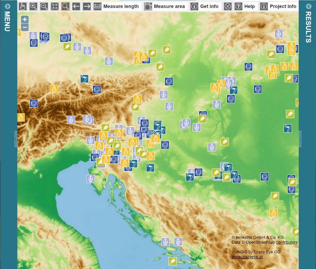
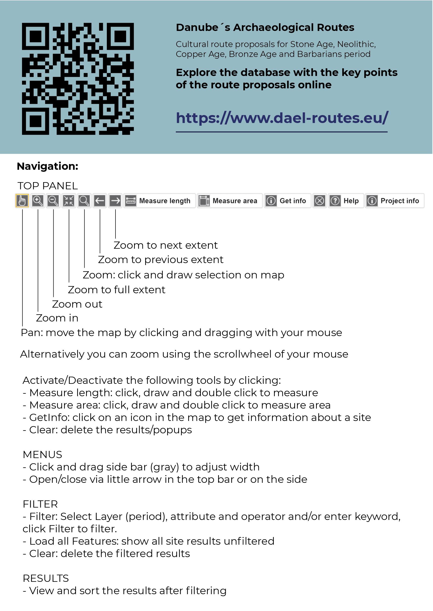
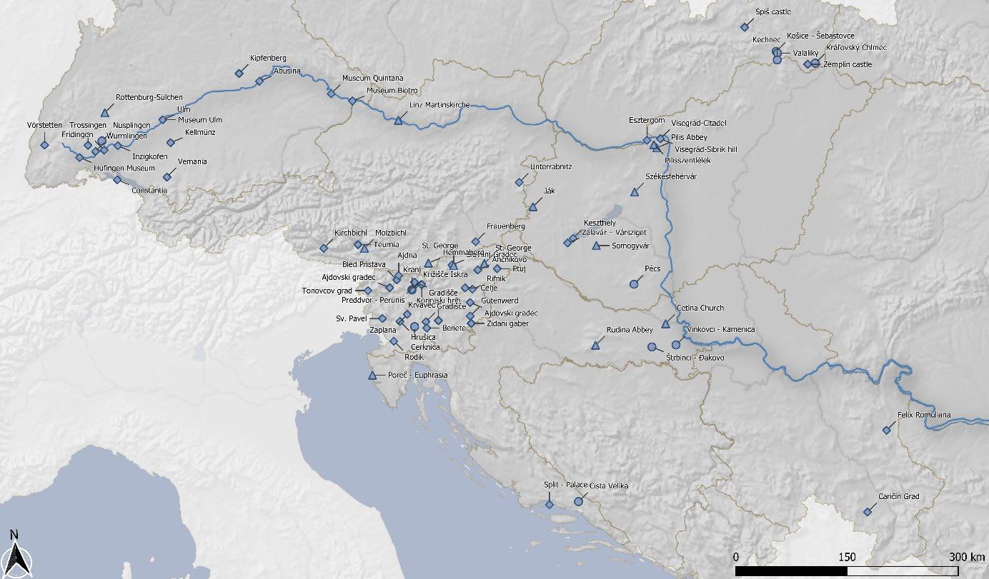
The physical implementation of the database was carried out by external experts in close collaboration with PP1. For the backend it was decided to use a geoserver hosted within the IT-infrastructure of the lead partner Universalmuseum Joanneum in Graz. To provide an attractive frontend the graphical design language was developed according to the Danube Transnational Program prerequisites. The main program colours were chosen to support the five different periods with a dedicated colour and individual icons were developed (Figure 1)
Figure 1: Map view of the web-frontend
The web-frontend consists of a landing page, with basic information to the project (Figure 2), to cultural routes and the 5 unique archaeological stories/themes. By clicking one of the icons a filtered periodic web-map can be accessed, where the collected destinations can be browsed and information on them can be obtained by every visitor (Figure 3).
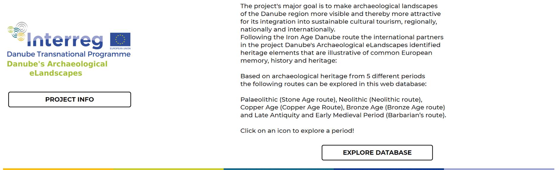
Figure 2: Project information on landing page

Figure 3: Navigation on the map on the web-frontend
3.2.3 Data analysis
From the collected data some information on the character of the selected candidates for each thematic period can be derived. The information on the visibility provided by the partners reveals, that there is big difference in the quality of archaeological heritage from different periods (Figure 4). Naturally prehistoric sites offer less visible remnant traces than sites from Late Antiquity and Early Medieval Times (often stone buildings and remaining ruins). Another differentiation can be seen between sites from early periods of humankind versus later periods. While at Neolithic, Copper and Bronze Age sites approx. a quarter has visible, but not interpreted archaeological heritage, this share is at 41% for Stone Age sites. All in all, the selection shows that a third of the most important archaeological sites still needs some support in the development of reconstructions and interpretations onsite.
Figure 4: Visibility of heritage
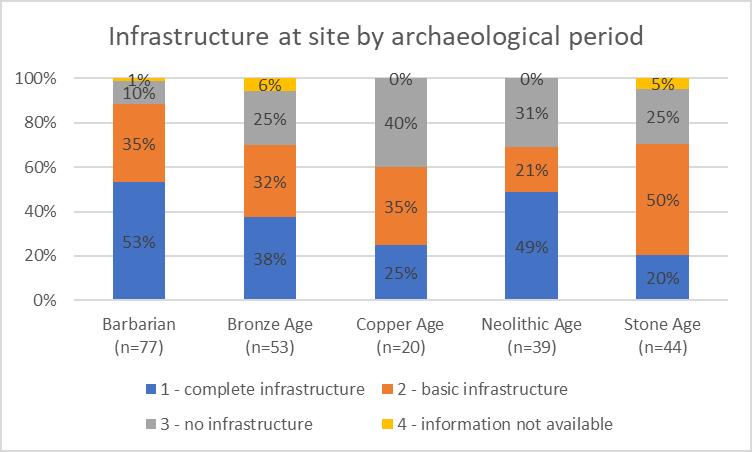
The evaluation of available infrastructure (restaurants, tourist info, public transport) at the sites and in their surroundings showed again differences for single periods (Figure 5). While 40% of sites suggested for the copper age route have no significant infrastructure developed, while this applies only to 10% of sites for a Barbarian route. Additionally, the Neolithic sites selected have the secondbest infrastructure with 49% of them fully developed. Half of the Stone age sites do have basic infrastructure, which can be considered a good number, due to their nature of often being off the beaten tracks.

Figure 5: Infrastructure at the sites and of their surroundings
The assessment of the touristic potential highlights again differences between prehistoric (Stone, Neolithic, Copper, Bronze Age) and early historic (Barbarians) periods (Figure 6. While the latter are by 57% already developed top tourist destinations and have by 31% good potential for development only 25% of Stone Age sites are already top destinations. With 55% the potential for development is considered as high. For almost 25% of sites from Neolithic, Copper and Bronze age the potential must be characterized as low and high investments would be necessary. Still, at almost 70% of them the potential is high or at least fair and they would profit from future initiatives.
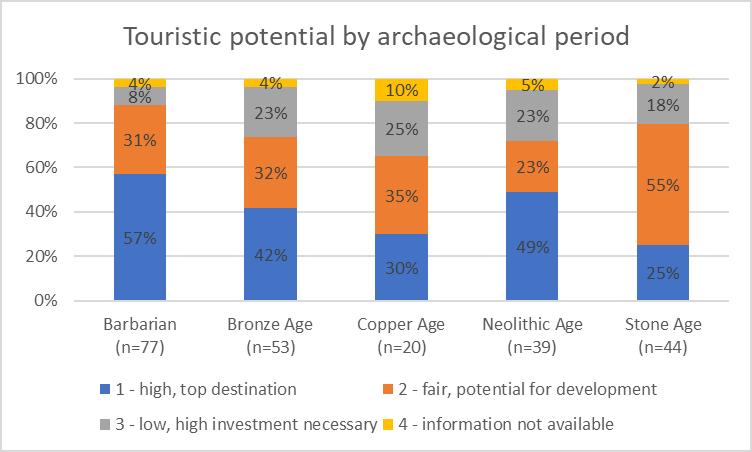
Figure 6: Touristic potential of archaeological sites and destinations and their surrounding
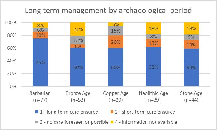
Another important factor for sustainable networks is the quality of the management of destinations and candidates (Figure 7). The assessment of the partners showed that at least for 75% long-term or at least short-term care can be assured. Again, destinations for a Barbarian route have the highest value with 85% and Bronze Age candidates need most attention in this regard (66% care assured). Future support should be given to stakeholders to rise the number of sites with ensured long term management even further for all selected sites.
4 Results – Online-presentation (Martin Fera)
The results of the data collection are presented with unique thematic stories at the webpage https://dael-routes.eu
The data can be accessed via the landing page and gives an overview of proposed destinations for the five thematic routes and gives options to get information on the collected sites. With the “Get Info”-button symbols on the map can be clicked for pop-up information (Figure 8).
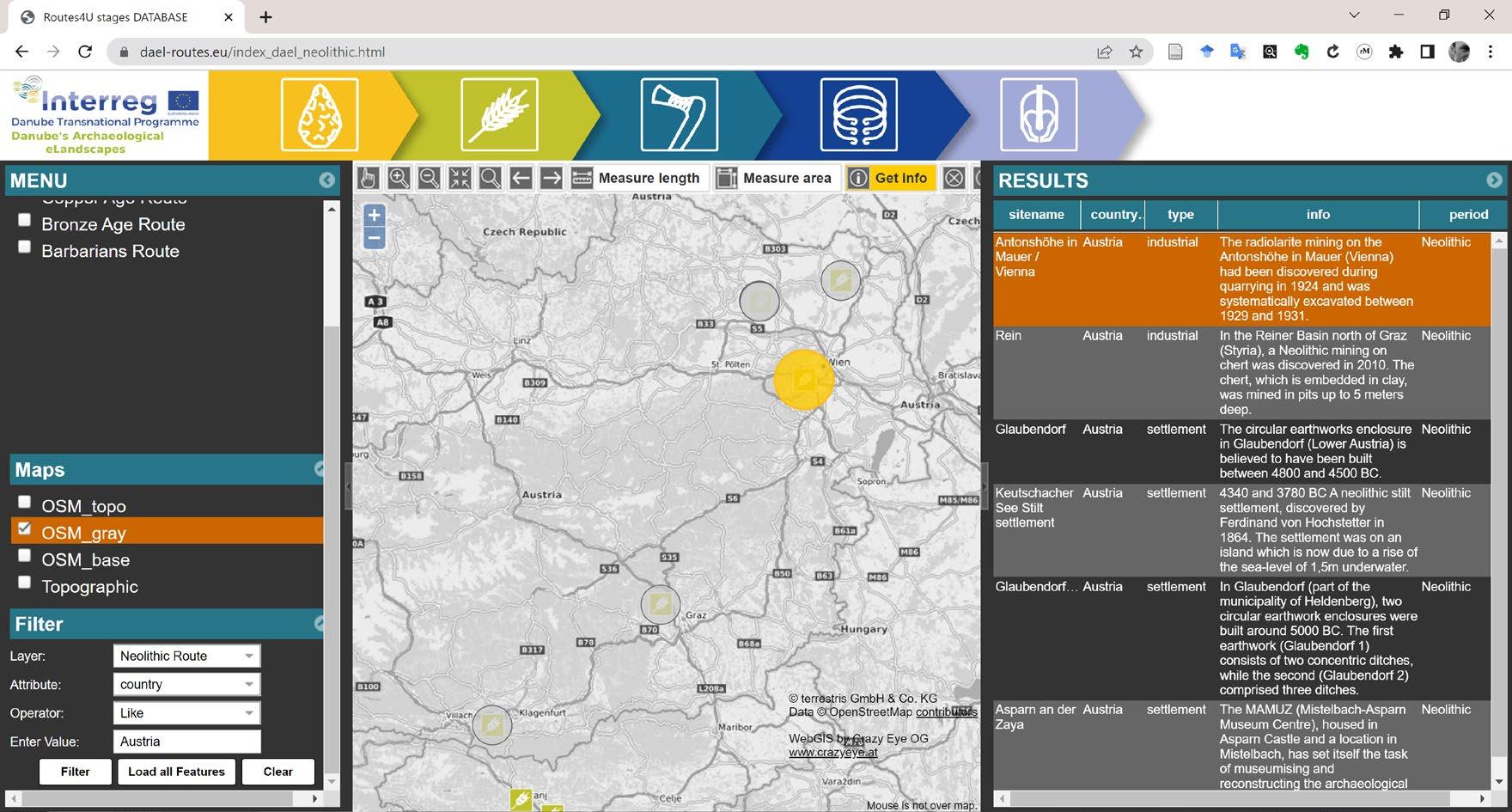
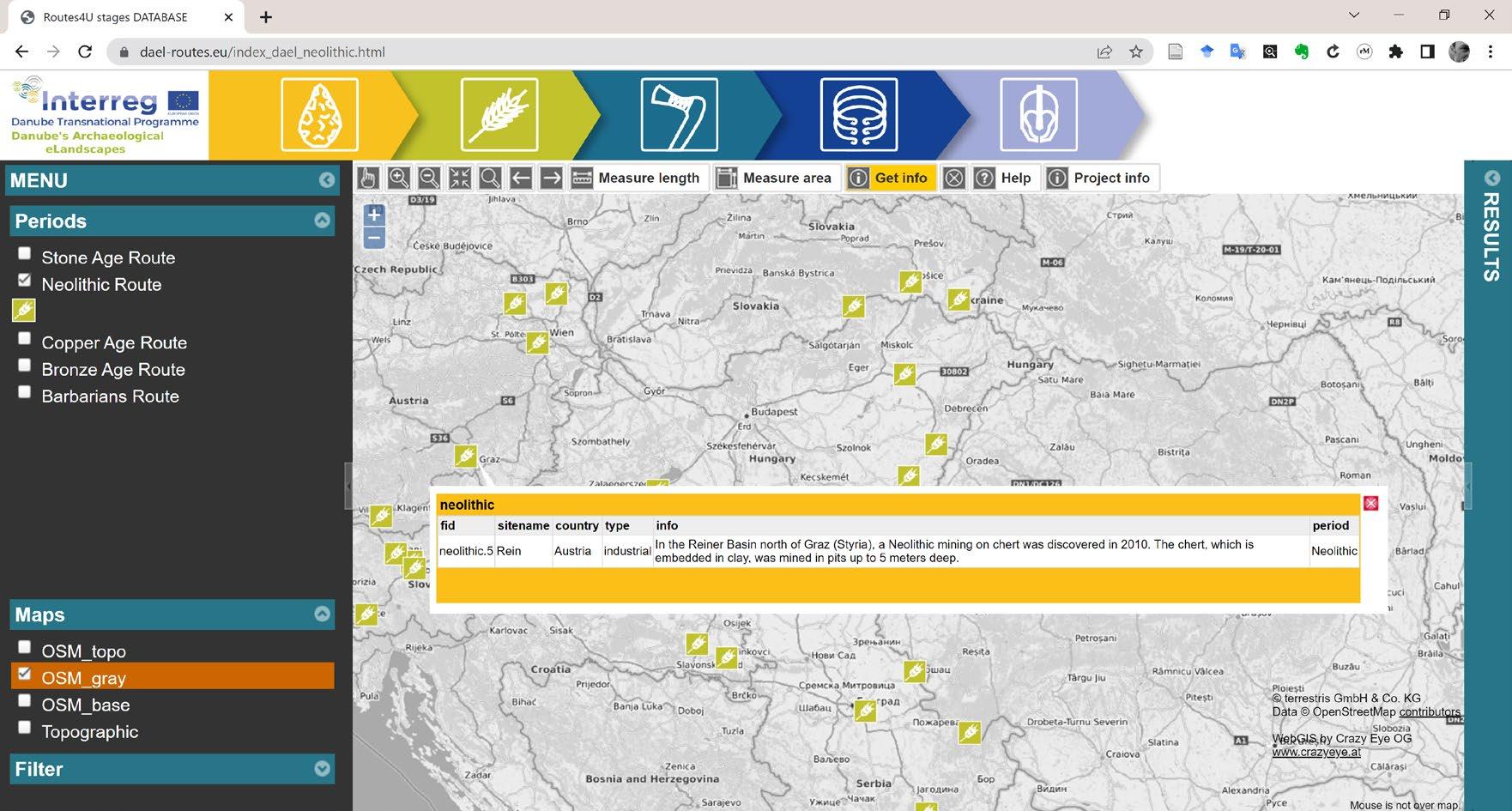
Figure 8: Pop-up information for selected symbols
The filtering option allows to filter by country, type of site or period. The results are shown as a table and highlighted in the map window (Figure 9).
Figure 9: Filtering the database by attributes
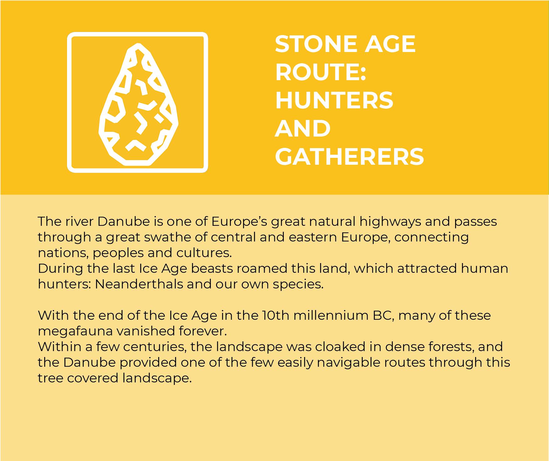
4.1 Stone Age Route: Hunters and Gatherers

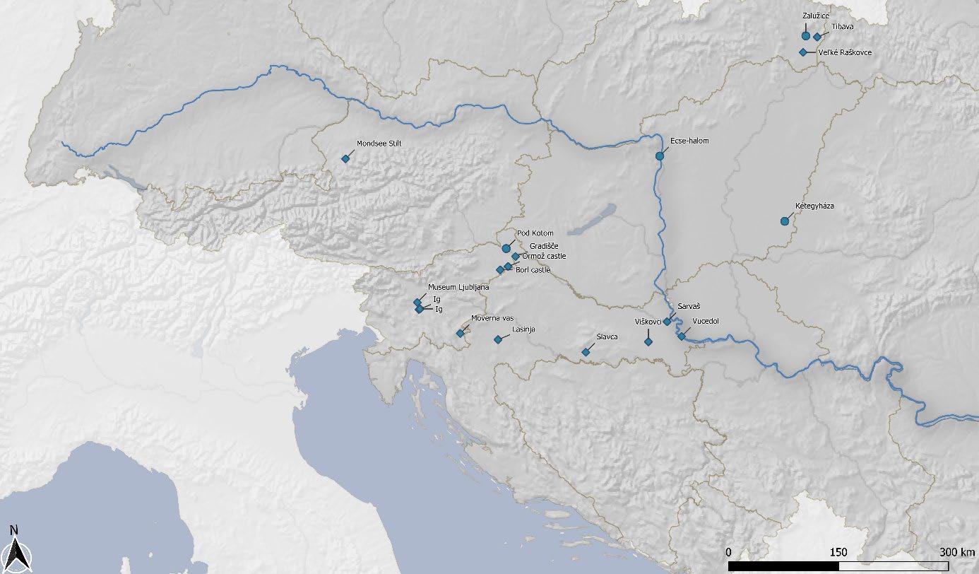
4.2 Neolithic Route: First Farmers and Early Herders
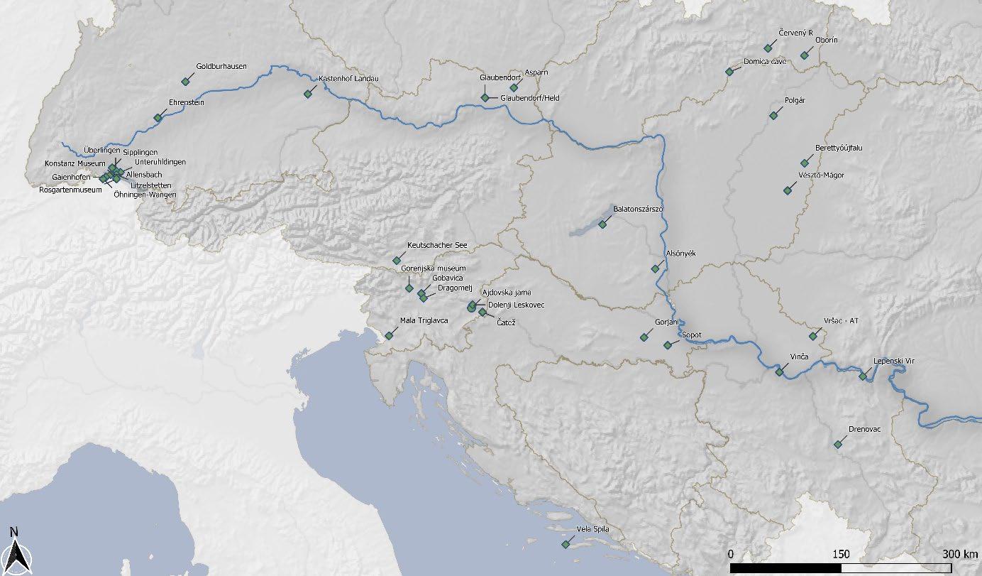

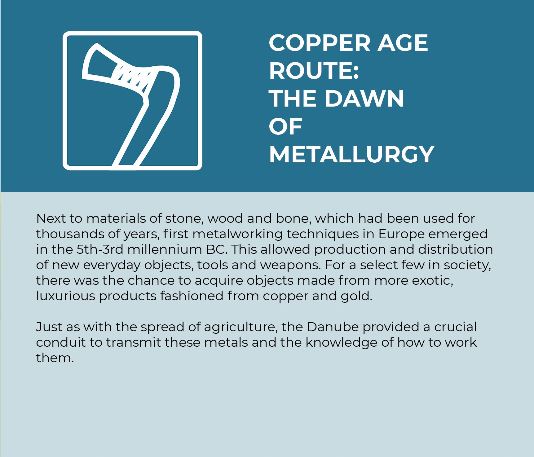
4.3 Copper Age Route: The Dawn of Metallurgy
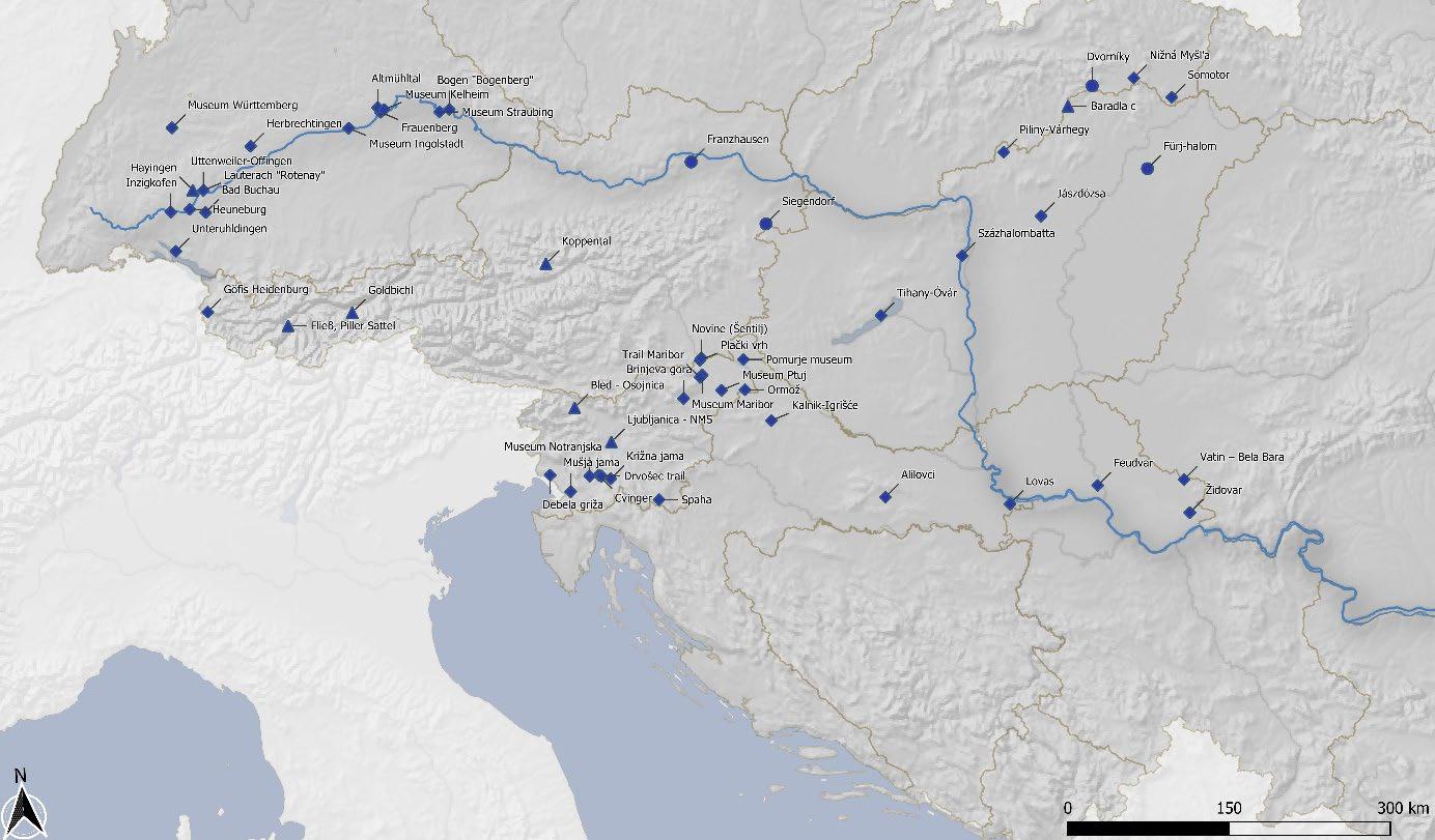
4.4 Bronze Age Route: Miners and Traders

4.5 Barbarians Route: The Fall of Rome and the Rise of Realms

5 Recommendations (Martin Fera)
For any cultural route there are many general elements that need to be considered; based on Pattanaro and Pistocchi (Pattanaro et al. 2016, Table 1) five general points should be addressed in the development of a Cultural Route:
1. Justification:
A justification for the proposed Routes can both be seen in attempts for the protection of cultural heritage as the economic development of regions in a sustainable way.
2. Goals:
Development goals and objectives need to be made clearly visible to decisionmakers and stakeholders and the benefit must be achievable to make it attractive to potential partners. Here a well working cooperation among actors is necessary and one of the tasks for an executive part of a dedicated network. First steps have been set by the workshops organised by the partners of the project in all countries during the year 2022. Further activities are necessary to identify and establish sustainable organisations who can take over the task of developing the goals of the individual routes further.
3. Inventory:
The inventory should include a list of assets and include as much information as available. The data collection has tried to consider the accessibility, the infrastructure and responsible management organisations in this first step, but clearly further measures are necessary.
4. Market potential:
To show potential partners and decision-makers the benefits of being included in such a network in-depth market research on the attractiveness of the theme, the touristic target groups and potential economic impact is needed. For this further funding should be sought.
5. Commercialisation of the itinerary:
Many individual steps are necessary to bring the Cultural Route from a valuable data collection of potential partners to an itinerary, where major points as accessibility and assets have been checked with partners and suggested stops and tourist facilities are chosen based on that. Here funding mechanisms are necessary and appropriate monitoring tools to assure the attractiveness for partners in a long-term.
