
Page left intentionally blank

Heritage Revival
Preserving Bengaluru’s Heritage Core & Enriching Spaces
By Darshan Thimmasandra Kenchappa
[ Student id : 22583388 ]
Report Submitted to Manchester School of Architecture
In Partial Fulfilment of the Requirements for the MA Architecture & Urbanism Degree


Copyright © 2023
All Rights Reserved
Manchester School of Architecture
Manchester Metropolitan University [Student ID : 22583388]
University of Manchester [Student ID : 11454292]
Supervisors:
Prof. Eamonn Canniffe , Prof. Sandeep Balagangadharan Menon, Prof. Purva Dewoolkar & Prof. Eddy Taylor
Author:
Darshan Thimmasandra Kenchappa
No part of this publication may be reproduced. Stored in a retrieval system, or transmitted in any form or by any means, electronics, mechanical, photocopying, recording, or otherwise, without prior permission of the copyright owner.
Acknowledgement
I would like to thank my supervisor Prof. Eamonn Canniffe for his invaluable guidance, unwavering support, and insightful feedback throughout the design studio. His expertise and encouragement have been instrumental in shaping my thesis project. I extend my appreciation to Prof. Sandeep Balagangadharan Menon, Prof. Purva Dewoolkar and Prof. Eddy Taylor for their thoughtful critique and valuable suggestions that have enriched the quality of this work.
I am grateful to my family and friends for their understanding, encouragement, and unwavering belief in my abilities. Their support has been a constant source of strength throughout this academic journey.


About
This report presents an examination and proposal for an inviting and pedestrian-oriented district located in the historical central nucleus of the city. The intention is to surmount the obstacles of rapid urbanization and place a stronger emphasis on the city’s historical landmarks. The study will investigate the response of the vicinity surrounding the heritage structures, the community’s attitude towards the heritage history, a detailed analysis of the infrastructure encircling these structures, and the interconnection among these comparable significant buildings.
Through this thorough analysis, a collection of strategies are formulated to enrich the communal spaces within this area, with the ultimate goal of fostering a positive forward-looking approach and an urban arena proposal that aims at enhancing the value of our heritage buildings.


Ink wash plan of Bangalore in 1791
The First map of Bangalore ever drawn and shows then fort and the petta area
The Bangalore Fort and Petta area hold pivotal historical significance in the city’s evolution. The Bangalore Fort, initially constructed by Kempe Gowda in the 16th century, served as a nucleus around which the city developed. Over the years, it became a strategic point for rulers and traders, contributing to the city’s growth. The fort’s influence extended to the Petta area, which developed as a bustling commercial center around the fort, catering to the needs of residents, traders, and visitors.
As Bangalore transformed into a prominent tech hub, the Fort and Petta areas retained their historical charm amidst modernization. At its rate of rapid urbanization, the city is constantly making efforts to preserve and revitalize these areas, recognizing their cultural and economic significance. These areas act as living reminders of Bangalore’s historical roots, embodying a blend of tradition and progress in the midst of rapid urbanization.

1935 Map of Bangalore.
Map after the establishment of British Cantonment in Bangalore.


Bangalore has been experiencing significant population growth in recent years, driven largely by its status as a technology and business hub. This rapid influx of people has led to accelerated urbanization, resulting in increased demand for housing, infrastructure, and services. The effects of this population growth and urbanization include congestion, strain on resources, and challenges in maintaining a balance between development and environmental sustainability. The city is grappling with the need to manage this growth while ensuring quality of life and preserving its unique cultural and historical heritage. Present


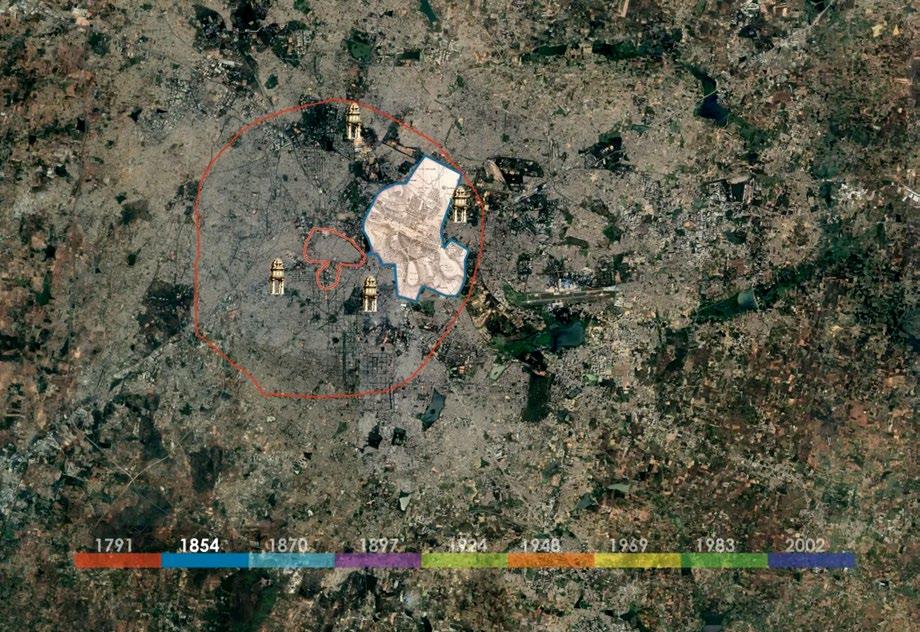
The contemporary Bangalore region encompasses an ancient inner-city sector of significant historical and cultural importance. This nucleus not only holds invaluable historical assets but also presents prospects for re energizing local economic advancement and strengthening the nation’s cultural identity. These urban heritage zones have the potential to serve as pivotal opportunities for both public and private investments, offering promising avenues for feasible and financially rewarding public-private partnership endeavors.
Viewing the historic heart of the city as the central point for its development, it becomes evident that expansion has occurred radially over the years, with recent times reflecting a remarkable growth percentage of nearly 500%. It is imperative to acknowledge the heritage values embedded within this central core and establish a framework that communicates the city’s history to all its visitors. Among these, the fort and the Tippu Palace area hold paramount significance.

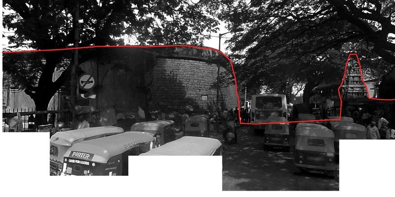
Holding fort is in a swamp of callousness. Presently fort has totally lost its identity. The fort stands out as a decrepit symbol of ignorance and neglect.
Most people, who stand opposite the fort waiting for buses, do not even know that there is a heritage site right behind them. Some thinks it may be some BBMP structure, most of the vendors who sale their goods along the fort wall don’t know historic importance of the fort. They have made holes with nails to hang their goods. Hospital entry near to fort, bus stand & vending activities makes area overcrowded. These activities are the reason for vanishing fort’s existence. Roads beside fort are not maintained, All garbage is spread over street only. Surrounding area is dominated by unhygienic conditions, Large hoardings near hospital & traffic congestion. Inside fort it is clean & maintained by archaeological department of India.


Small Community of Bamboo weavers. Active through the day and closed in the night

Different
Playground & school active through the day and shut in the night.
Events space is active through the night
Heritage buildings. Active through the day and shut after evening
Transit zone with metro stations. Active throughout day & night
The majority of activity in the region occurs during daylight hours, with minimal significant events happening at night, except for the metro stations. The primary spine of the selected study area exhibits a diverse utilization of spaces, encompassing heritage buildings.
Market & Fort area . Active through the day & shut in the night.
Vehicular movement in the street
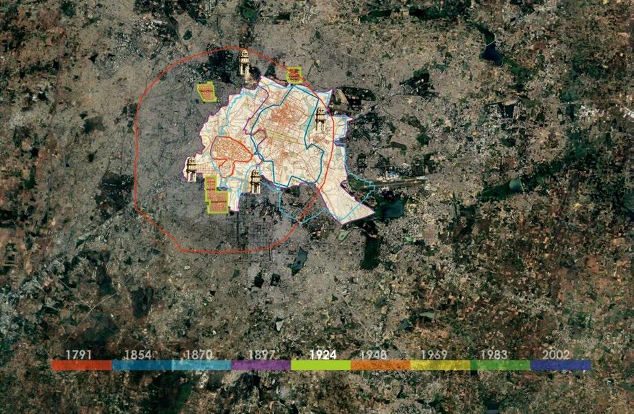
By examining the land use map, it becomes apparent that the majority of the zones consist of public spaces, while the remaining areas are dedicated to commercial use. The old colonialstyle heritage buildings have undergone privatization, transforming into public hospitality zones that dominate a significant portion of our designated study area. Within these zones, numerous unregulated new constructions are emerging without adherence to guidelines for facades and construction types, necessitating immediate regulation.
The continuity of commercial land use typology since historic times is the driving force behind the Pete area.
We can also conclude from the observation that there are very minimal public spaces available for the pedestrian usage.


Upon analyzing the road network, it is evident that buses traverse most roads, excluding narrower ones. The bus route passes in proximity to heritage buildings, yet none of the roads feature dedicated bus lanes, resulting in congestion, particularly during peak hours near bus stops.
The marked nodes are spacious, but inadequate planning has resulted in unused areas within these nodes. There is a pressing need for infrastructure upgrades on the streets connecting these nodes. Additionally, these streets lack cycle tracks and green buffer zones between the roadway and the footpath. The footpath width is often limited, and the presence of trees growing in the middle of these pathways contributes to congestion.

Legend :
Study Area
Student Movement
Public Transit
Movement
Potential Heritage
Walk Map
Heritage Buildings


Minimal Human Activity
Medium Human Activity
High Human Activity
After examining the activity map, it is evident that the predominant activity between the palace and fort is attributed to individuals using the metro station. The level of human activity is notably elevated in the market area, namely the Pete area.
Due to the privatization of the area containing colonial buildings, there is limited potential for the redevelopment of these structures or the surrounding space. However, there exists an opportunity to implement a heritage walk that encompasses both historic and colonial buildings. This initiative aims to educate people about the city’s historical core.


Human Activity Map


Legend :
Connection between
heritage buildings
Minor Streets
Major Streets
Colonial Buildings
Heritage Buildings
The objective for the specified area is to bring about a fresh perspective to the city’s urban core. It is advisable to create more pedestrian-friendly zones and revamp the connecting streets. Unused spaces within open sites present an opportunity for re purposing, whether for functional urban furniture or landscaping.
Upon reviewing the layout, it is evident that there is a visual connection between two heritage structures. This connection could be strengthened by eliminating some of the unused buildings and other urban infrastructure.


The historical heart of Bengaluru city is being overshadowed by the growing demands of urbanization, and neglect toward heritage is a clear consequence of this trend. Despite government efforts to preserve these structures against the encroachment of surrounding developments, street hawkers persist in trying to encroach upon the boundaries of these heritage sites. While the Tippu Palace and palace temple are wellmaintained, the other two structures, the Fort and Armory, are neglected by the development authority.
Several architectural practices have attempted to formulate a master plan for heritage revival to restore the charm of these structures. However, practical execution has proven challenging. Despite these challenges, ongoing efforts include initiatives such as organizing heritage walks around these structures to educate people about their significance.
In this proposal, I aim to deviate slightly from the traditional restoration approach by introducing a pedestrian precinct and creating a landmark around these heritage structures to attract and educate people about their existence. This can be achieved in various ways. The approach I am taking involves pedestrianizing a street between two major heritage structures and redesigning the road leading to it.
The design is centered around providing maximum comfort for pedestrians and shifting the focus to be more peoplecentric rather than car-centric.
Heritage Structures

Initial Master Plan Idea
The Master plan can be categorized into two developmental zones for easier elaboration. The primary zone, known as the Fort Arena, is situated between the Tippu Palace and Bengaluru Fort area. The vision for this area involves a complete transformation into a distinctive landmark featuring vibrant colors. Two prominent roof structures are proposed to facilitate various seasonal activities. The objective is to depart from conventional approaches to heritage building revitalization by establishing a new pedestrian-oriented zone between heritage buildings spaced 350 meters apart.
The secondary zone involves the redesign of Krishna Rajendra road leading to the Fort Arena, currently congested with vehicles during peak times. The goal is to expand pedestrian footpaths, introduce cycle tracks on both sides, and create a landscape buffer between motorways and pedestrian zones. Proposed

The Buses overpower the pedestrians
The streets are narrow and can be converted into complete pedestrian zone

Government Initiations to develop the area to improve urban infrastructure
Huge opportunity to improve the area in front of the heritage building Presence of natural several natural trees next to the fort
Very minimal space available for the pedestrians and no clear footpath area
Opportunities on Top
Issues On Bottom
Issues & Opportunities Around the Fort Area
Too many Autorickshaw vehicles around the area Street Vendors have occupied the space in front of the heritage buildings
1. Existing building arrangement

2. View Angles from Fort to Palace

3. Envisioned Proposal Area retaining Metro Blocks

Development of the Area

4. Building Facade Exposed to Arena

5. Orientation for the Layout

6. Introduction of Roof Structure

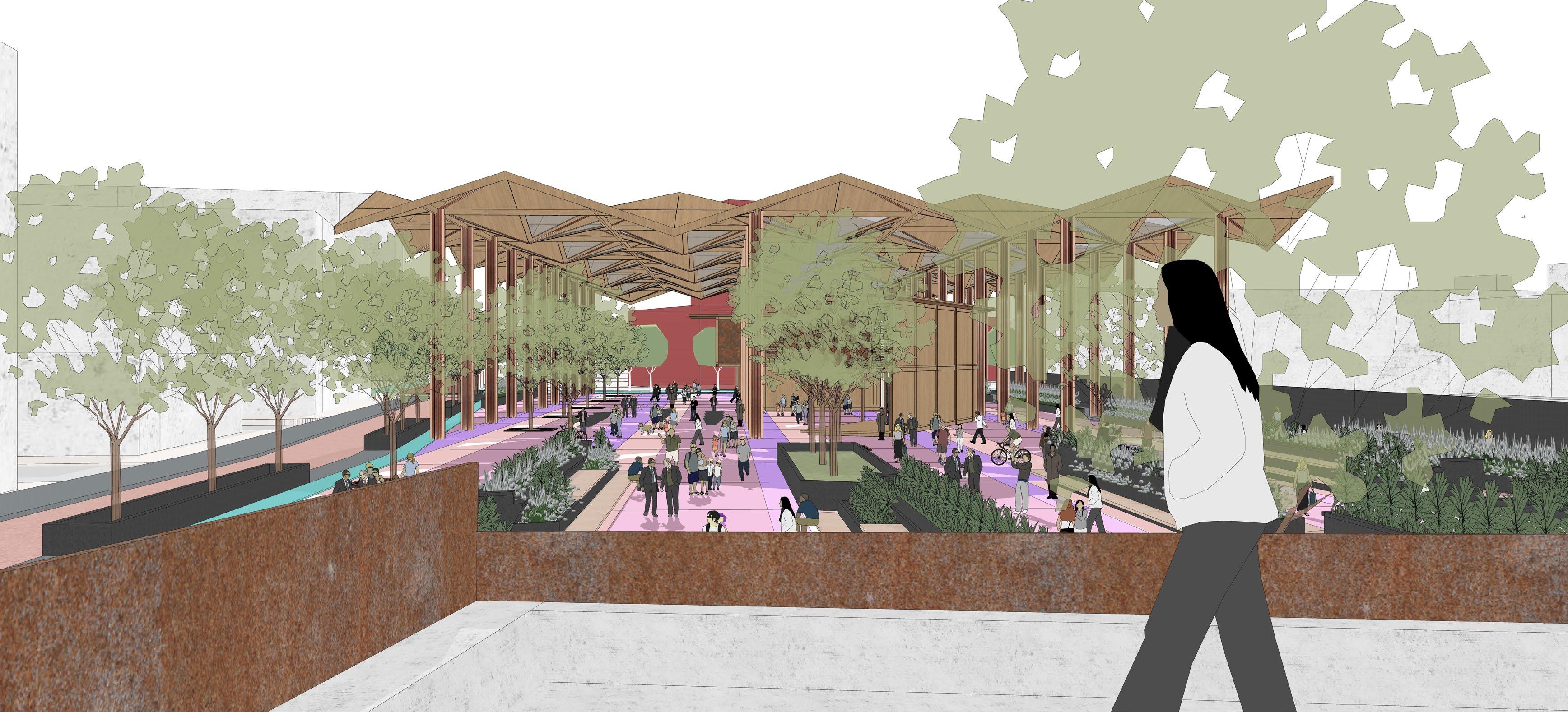
The inception of this concept was driven by the aspiration to transform the entire area into an expansive pedestrian zone, serving as a distinctive landmark within the historical heart of Bengaluru’s urban landscape. The current operational motorway is slated to undergo a transformation into a fully pedestrianized space, achieved by rerouting traffic around the buildings along the perimeter. The primary goal is to establish a spacious, linear arena characterized by vibrant elements that can host a diverse range of events, evolving with the changing seasons.
Initial Idea for the Fort Arena

The Fort Arena derives its name from the Bengaluru Fort, serving as the backdrop for this envisioned space. The layout is elongated, measuring approximately 340 m x 52 m. Consistent with this linear theme, most elements, including benches, planters, and other street furniture, follow a cohesive design language. A dedicated zone within the area features a cycle track, pedestrian pathway, and building frontage for structures along the perimeter. Trees are strategically arranged in a grid pattern to ensure an unobstructed view of the fort and Tippu Palace from various angles. In essence, the overall design imparts a dynamic and lively ambiance to the entire zone.


1. The I-shaped sections measuring 300x125x15mm are positioned at right angles to one another, creating a cross-like configuration around a central square steel member that serves as the cohesive element. The diagonal components extend outward to serve as the cross bracing for the roof structure.

2. The square grid can be divided into triangles, incorporating diagonal members that extend from the diagonal arrangement of the columns. Additionally, it can be further subdivided into smaller triangular units to create modular roof panels for straightforward assembly.
3. The square grids can be arranged in proximity to form a pattern, establishing a network of diagonal triangular members interconnecting to secure the roof panels in place.
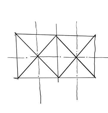
4. The diagonal members originating from the column arrangement can be raised in the center of the grid, forming a pitched roof-like structure, while the adjacent grid simultaneously descends for an equal length. This results in a controlled alternation between peaks and troughs throughout the entire structure.

5. The total height of the structure is maintained at 13 meters above ground level, incorporating a peak and trough elevation of 1.5 meters. This design imparts both austerity and grandeur to the structure, providing an elegant space for diverse activities beneath it.

Development of the Roof Structure

300 x 125 x 125 mm I steel member
125 x 125mm steel member
100 x 100 x 15 mm
L angle as diagonal member
Timber covering around the steel members


The depicted illustration reveals the arrangement in which the entire roof structure is constructed. Clearly, the originally square grid design is subdivided into smaller triangular sections, constituting roof panels securely fastened together. At first glance, the overall layout appears to be a series of adjacent square grids. However, it is actually a composition of triangular elements that are elevated at specific points, forming a distinctive and sturdy wavelike pattern. The area beneath the structure is open and versatile, accommodating a range of activities that vary with different seasons.
Development of the Roof Structure


Another view showing the newly proposed modular exhibit area along with organic seating in front of it under the massive roof structure. The columns are plated with copper to achieve a rich feel.

The steel and timber modular framed structure is assembled using bolts, allowing for easy disassembly and relocation as needed. This versatile structure serves as a seasonal shelter beneath an impressive roof. It consists of I channels enveloped in timber, providing a uniform appearance.
With a two-floor design, the ground floor is designated for art exhibitions, while the upper floor accommodates workshops and a small museum. The predominantly flat roof emphasizes the overall horizontal nature of the unit


Krishna Rajendra Road, situated in the study area, encounters significant traffic congestion, especially during the evenings. There is a clear imperative to overhaul its layout, shifting the focus from being car-centric to more pedestrian-oriented. The plan builds upon the current street blueprint established by local authorities, introducing modifications to both the motorway and footpath widths. A key aspect of the proposal involves the implementation of a cycle track and an expanded footpath, achieved by judiciously reducing the motorway width to accommodate single-lane traffic.
Initial Street Design Idea


Internal Pedestrian Only Path
The bustling thoroughfare in the central region of the selected study zone undergoes a transformation to enhance its pedestrian-friendliness. The current multi-lane motorway is streamlined to a single lane, while the width of the pedestrian walkway is expanded. Adjacent to the motorway, new cycle tracks are introduced, one of which features a green buffer. Furthermore, a separate pedestrian-only pathway is created within the designated development site, accommodating a pavilion with a roof. The proportion of greenery is augmented to not only improve air quality but also serve as a natural filter amid the continuous traffic growth. Footpath
Proposed Street Design
