Cascade Mountain Views Tumalo Home on Acreage
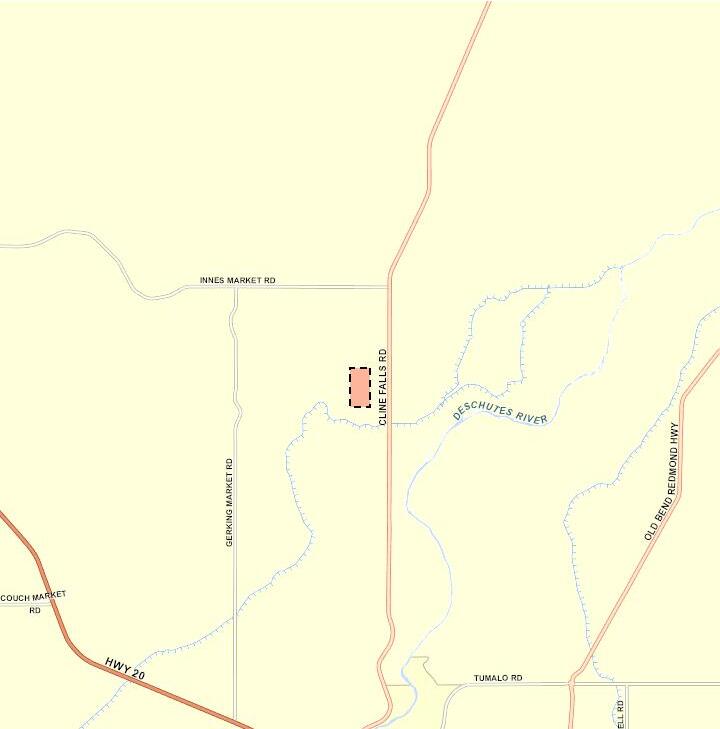
Address: 19925 J W Brown Rd Bend, OR 97703
Tax Map: 161218 00600 Parcel #132458
Property:
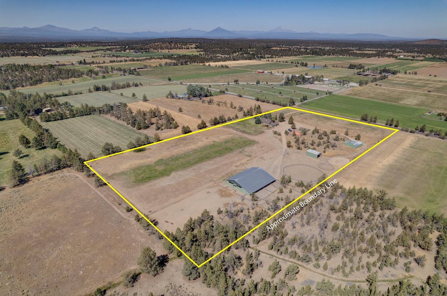
• 19.84 acres with 12 acres TID water rights, pond on a float. Irrigated with wheel lines and hand lines.
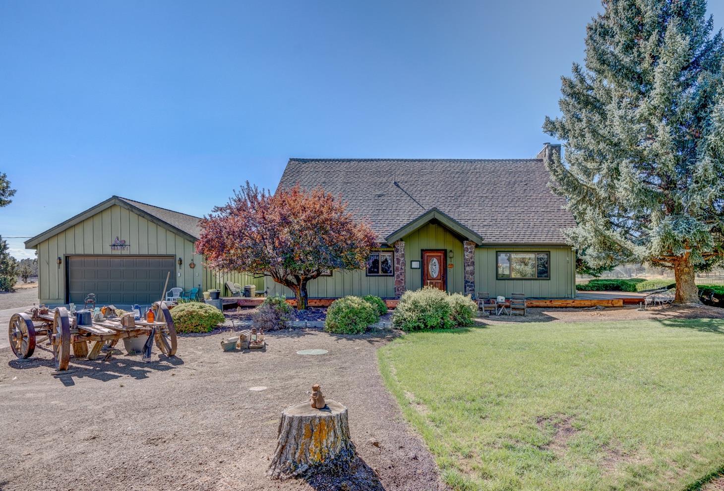
• House is 3035 sq ft 3 bedrooms, 2.5 bathrooms built in 1979. Living room with vaulted ceilings, wood stove and views, dining area, office, utility room with sink.
• Primary is on main, 2 bedrooms and a bathroom upstairs with a loft.
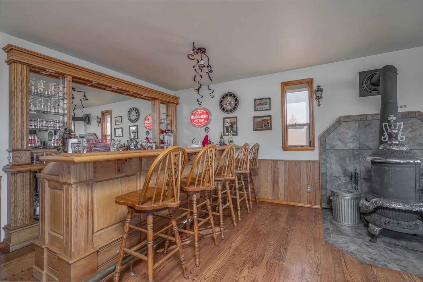
• Bonus/Game room is approx. 700 sq ft with Bar and antique wood stove. Not included in the home sq ft on assessor records – permits were pulled, but not final.
• 2 car attached garage
• Home is heated with electric forced air furnace, heat pump and wood stove. Water Heater in closet works, but is not connected. Tankless water heater is currently servicing the house.
• Decks, Fire pit and Wonderful Yard. Lawn is irrigated with TID water rights (not the well).
• Indoor Arena 11,280 sq ft, 6 stalls with runs, tack room, wash rack
• 2 Outdoor Round Pens: 120 ft and 60 ft
• Hay Barn
• Detached shop/garage/office
• Equipment shed/storage building
• Cascade Mountain Views
Irrigation: 12 acres water rights delivered by Tumalo Irrigation District to the Pond. Pond is on a float. Assessment for 2024 $2006.
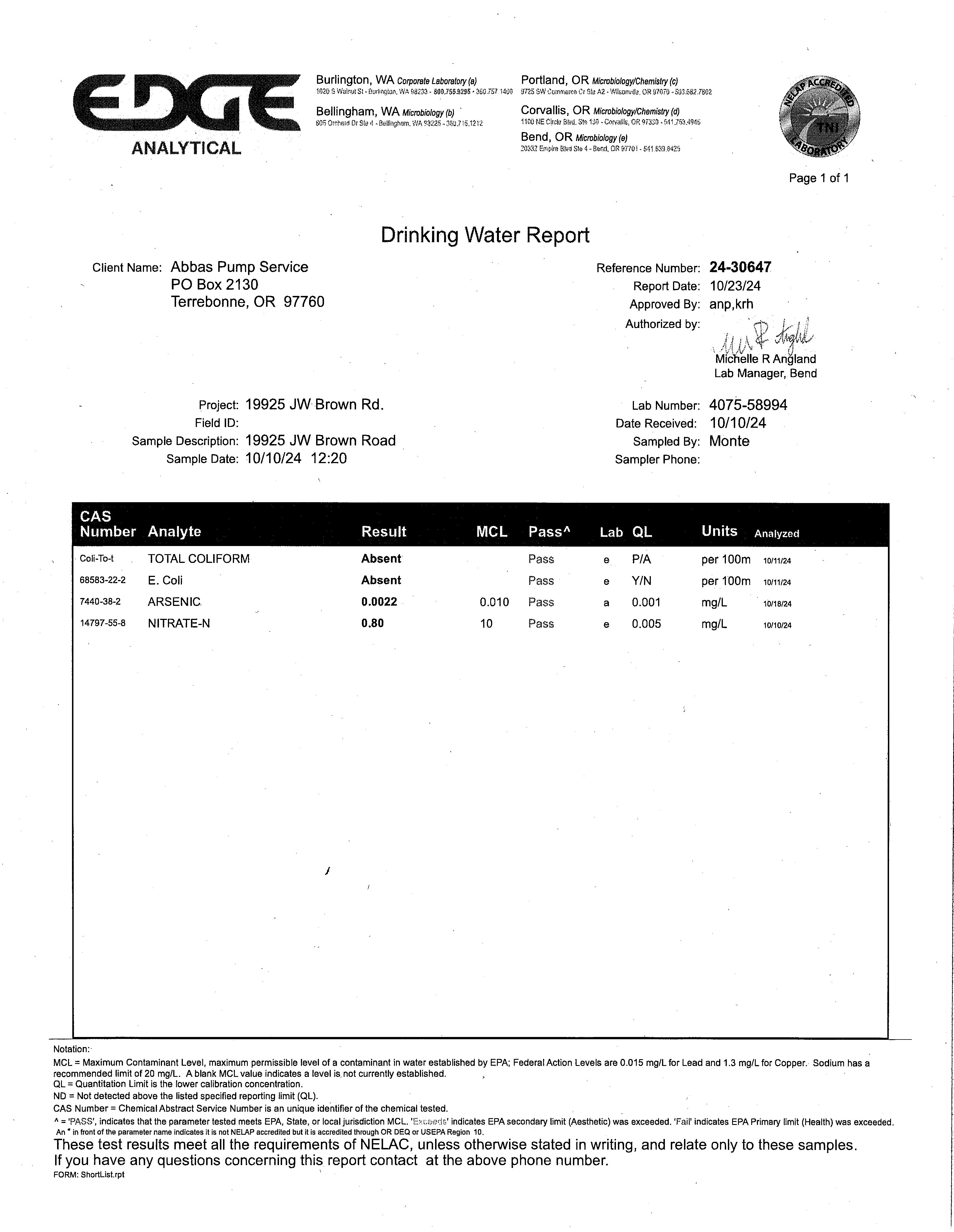
Domestic Water: Private Well
Utilities: Pacific Power-3 meters. Residential: 12 month average: $254./month High:$563.
General Service/Shop: 12 month Average: $47./month
Irrigation Pump: Season/month Average $103./month High: $123./month
Taxes: 2024 $7,762.00 Property is in Farm Tax Deferral. Buyer is responsible for due diligence and maintaining after the Close of Escrow.
Zoning: EFU – Exclusive Farm Use
Price: $1,525,000. MLS 220193710
Shown By Appointment Only
All information Provided by Cascade Sotheby’s International Realty and Agents is deemed reliable but not guaranteed, Buyer is responsible for any/all due diligence. | 541-923-1376 | www.desertvalleygroup.com
CLINE BUTTES RECREATION AREA
The Cline Buttes Recreation Area is managed by the Prineville District BLM. The area is undergoing trail and trailhead development, route decomissioning and fuels reduction projects. Please keep in mind the following when visiting the area:
AREAS:
TRAIL USE
• The Recreation Area has been divided into different trail use areas.
• This map shows the allowable trail uses for each area, such as: and
• As trail systems are developed in each area, motorized, mechanized and equestrian use will be restricted to designated trails.
ACCESS:
• Many access points will change as shown on the map due to private property boundaries and sensitive resources.
• Vehicle access is no longer allowed to the top of the buttes. The majority of land on the buttes is private property.
FIREARM USE: Care should be taken when using firearms in the recreation area. BLM lands east of Barr Road are closed to firearm discharge unless legally hunting. The Tumalo Canal Historic Area and smaller parcels along the Deschutes River are closed to all firearm discharge. Closed to firearm discharge except when legally hunting Closed to all firearm discharge Closed to all firearm discharge seasonally (Feb. 1 to Aug. 31) Recreation Area lands with no firearm restriction TRAIL USE: MASTON Separate trails will be developed for equestrian and mountain bike use. HIkers can use all trails. Trails into the Deschutes River Canyon and along the river are for pedestrian use only. Trails will be developed to minimize habitat fragmentation and disturbance to birds of prey, with some of the area under a seasonal closure. The Maston Area is closed to motorized use.
BUTTES : Separate trails will be developed for equestrian and mountain bike use. Hikers can use all trails. The Buttes Area is closed to motorized use.
TUMALO HISTORIC AREA : Interpretive trails along relic canals are for pedestrian use only. Trails in the south portion of the Historic Area (including South Boundary Road) are for equestrian, mountain bike and pedestrian use. The Historic Area is closed to motorized use.
SOUTHWEST AREA : Trails are being developed for shared use by all non-motorizeduses (including equestrian, pedestrian and mountain bike). Some trails have seasonal closures to minimize disturbance to nesting birds of prey. The Southwest Area is closed to motorized use.
CENTRAL OHV AREA : Trails are being developed for OHV use, including motorcycle only trails, motorcycle/quad trails, jeep trails and rock crawl/play areas. Some trails have seasonal closures to minimize disturbance to nesting birds of prey. OHV trails are also open to non-motorized uses. DEEP CANYON AREA Trails are being developed for pedestrian and equestrian use only. Trails will be designed to minimize disturbance to birds of prey, with some of the area under a seasonal closure. The Deep Canyon Area is closed to motorized use.
or by
Please contact
STA TE OF OREGON
WATER SUPPLY WELL REPORT
START CARD# 1028949
(as required by ORS 537.765 & OAR 690-205-0210) 12/17/2015 ORIGINAL LOG# DES C HUTES ls24s
(1) LAND OWNER
Fir Co Ad
Owner Well I.D
st Name SUSAN La st Name MANIS
mpan y dress 19925 JW BROWN RD
Ci n:: BEND State OR Zip 97701
(2) TYPE OF WORK DNew Well [8J Deepening D Conversion
)(t"Alteration (complete 2a & 10) Sa) ) PRE-AL TERA TION
Dia + From To Gauge St! Piste Wld Thrd Casing: C=:J I I I I llU OD D
Material From To Amt sacks / lbs Seal: I I I I I
DRILL METHOD
[8}Rotary Air 0Rotary Mud Ocable 0Auger Ocable Mud D Reverse Rotary D Other (3)
(4) PROPOSED USE [8J Domestic Otrrigation Ocommunity D Industrial / Commericial D Livestock D Dewatering
0Thermal 0Injection D Other
(5) BORE HOLE CONSTRUCTION Special Standard 0 (Attach copy)
Depth of Completed Well 670 00 ft
BOREHOLE SEAL sacks/ Dia From To Material From To Amt lbs
8 0 550 I I I 6 550 670 Calculated I I I l Calculated
How was seal placed Method [8)0ther NOT DISTURBED DA Os De Do DE
Backfill placed from ft to ft Material
Filter pack from ft to ft Material Size
Explosives used : Oves Type Amount
(Sa ) ABANDONMENT USING UNHYDRA TED BENTONITE
Propo s ed Amount Actual Amount (6) CASING/LINER
Casing Liner Dia + From To Gauge Stl Piste Wld Thrd
670 188 (] [8] D Shoe D Inside ooutside D Other Location of shoe(s) Temp casing Oves Dia From To PERFORATIONS/SCREENS
Perforations Method TOURCH CUT (7) Screens Type Material
Perf/ Casing/ Screen Scrn/slot Slot #of Tele/ Screen Liner Dia From To width lenoth slots nine size
Perf Liner 5 650 670 125 3 86
(9) LOCATION OF WELL (legal description)
County DES C H UTES N/ S Range 12 00 E E/ WWM Sec 18 NE
Flowing Artesian ? D Dry Hole ? D WATER BEARING ZONES Depth water was
(11) WELL LOG Ground
Date Started 1211012015 Completed 1211112015
(unbonded) Water Well Constructor Certification
I certify that the work I performed on the construction , deepening , alteration , or abandonment of this well is in compliance with Oregon water supply well construction standards Materials used and information reported above are true to the best of my knowledge and belief
License Number 1276 Date 12/16/ 2015
Signed VINCENT MACKEY {E-filed}
(bonded) Water Well Constructor Certification
I accept responsibility for the construction , deepening , alteration , or abandonment work performed on this well during the construction dates reported above All work performed during this time is in compliance with Oregon water supply well construction standards This report is true to the best of my knowledge and be! ie f.
License Number 1720 Date 12/17/ 2015
Signed JACK ABBAS {E-filed} Contact Info (optional) JACK ABBAS
Deschutes County Property Information
Report Date: 1/8/2025 12:50:30 PM
The information and maps presented in this report are provided for your convenience. Every reasonable effort has been made to assure the accuracy of the data and associated maps. Deschutes County makes no warranty, representation or guarantee as to the content, sequence, accuracy, timeliness or completeness of any of the data provided herein. Deschutes County explicitly disclaims any representations and warranties, including, without limitation, the implied warranties of merchantability and fitness for a particular purpose. Deschutes County shall assume no liability for any errors, omissions, or inaccuracies in the information provided regardless of how caused. Deschutes County assumes no liability for any decisions made or actions taken or not taken by the user of this information or data furnished hereunder.
Account Summary
Subdivision:
Property Class: 551 -- FARM
Warnings, Notations, and Special Assessments
Assessor's Office Notations
Review of digital records maintained by the Deschutes County Assessor’s Office, Tax Office, Finance Office, and the Community Development Department indicates that there are County tax, assessment, or property development related notations associated with this account and that have been identified above. Independent verification of the presence of additional Deschutes County tax, assessment, development, and other property related considerations is recommended. Confirmation is commonly provided by title companies, real estate agents, developers, engineering and surveying firms, and other parties who are involved in property transactions or property development. In addition, County departments may be contacted directly to discuss the information.
Valuation History All values are as of January 1 of each year. Tax year is July 1st through June 30th of each year.
Veterans Exemption
Tax Payment History
Sales History
Structures
Land Characteristics
Ownership
Related Accounts
Related accounts apply to a property that may be on one map and tax lot but due to billing have more than one account. This occurs when a property is in multiple tax code areas. In other cases there may be business personal property or a manufactured home on this property that is not in the same ownership as the land.
No Related Accounts found.
Development Summary
Deschutes County Permits


