Shop and Custom Home in the Pines
Address: 16685 Buckhorn Lane Sisters, OR 97759
Tax Map: 151002D 00500
Parcel #142961
Property: 4.6 acres in the pine trees, minutes from Sisters, OR
Improvements:
• Traditional Style Home is 3057 sq ft, 3 bedrooms, 2.5 bathrooms with vaulted ceilings and great room ready for entertaining. Built in 1975, updated/remodeled in the last 5 years.
• Chef's kitchen is big with quality appliances: Viking double oven, Thermador 6 burner propane stove top with pot filler, Miele Dishwasher , Subzero refrigerator. Farm Sink, solid countertops (granite/quartz), breakfast bar, farm sink, insta-hot, custom cabinets and pantry.
• Open floorplan with large living room that is light and bright. TV, Couch and glass table are included.
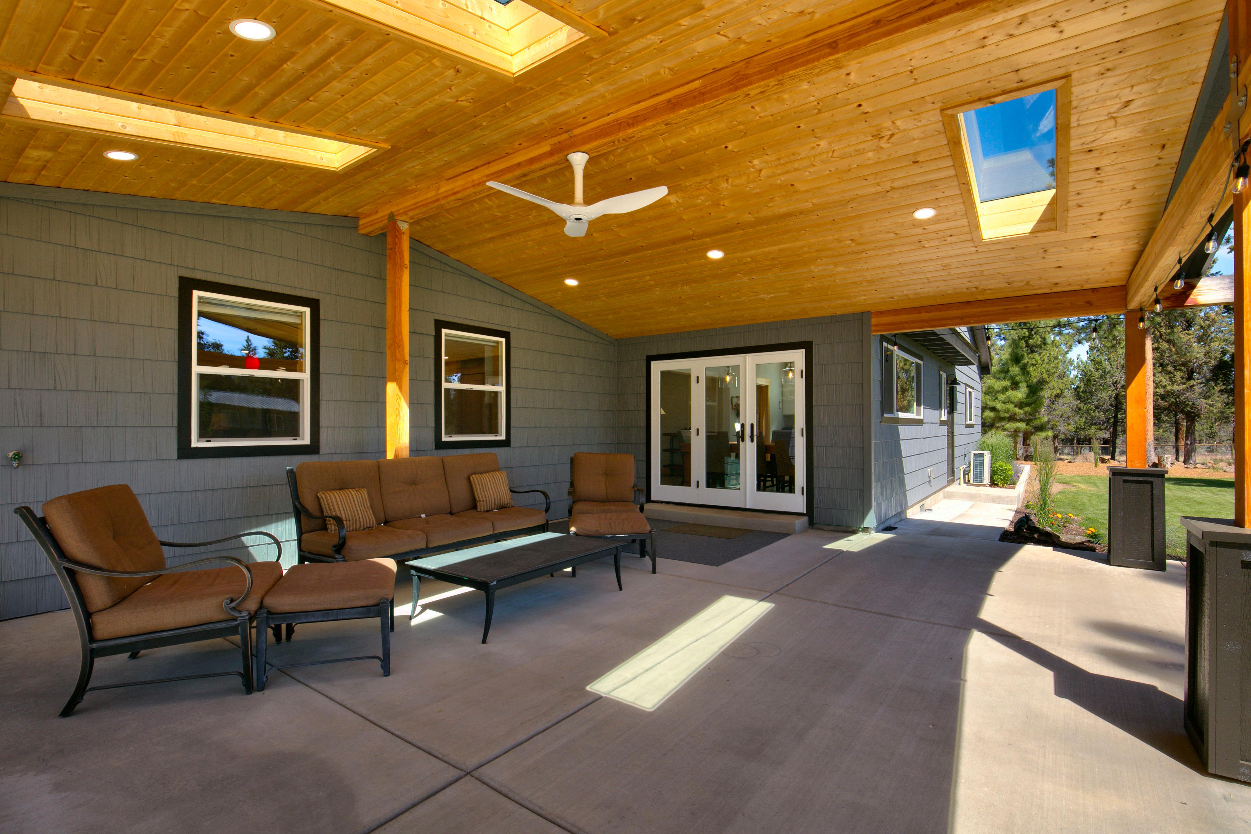
• Dining room with custom cherry dining room table included, skylight and access to the paver patio
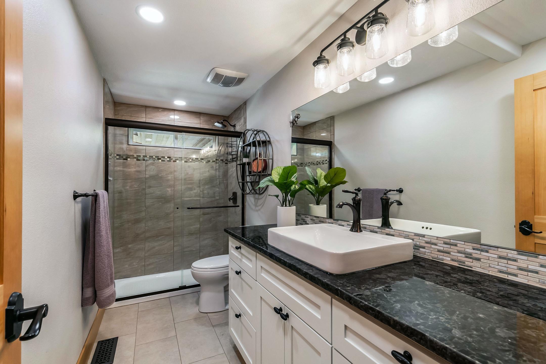
• Private upstairs master suite with tile shower, walk in closet, peekaboo Cascade Mountain Views
• Office/utility room
• Attached 2 car garage with sauna and epoxy floors.
• Central Vac
• Heating/Cooling: Forced Air Electric Furnace, Heat Pump, Ductless heat pump and Yotel woodstove
• Wonderful outdoor living with covered patio and hot tub in the private back yard with automatic sprinklers/dripline – 16 zones
• The 2880 sq ft shop includes: 2 studios with bathrooms, RV storage 50 amp power and full hookups, attached garage, work area and storage.
• Barn/Equipment storage – 24x24
• 2 storage containers (240 ft long) and woodshed
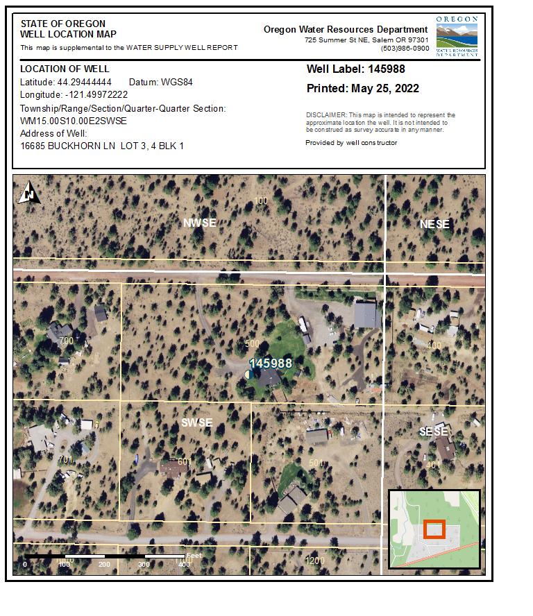
Domestic Water: Private Well – new in 2022
Utilities: Central Electric Coop (CEC) 12 month average $288./month, High $431./month Low $160./month Propane tanks for stovetop and BBQ – 2 100 gallon tanks included.
Taxes: $6805.27 Tax Year 2022
Zoning: RR10 Rural Residential
Price: $1,395,000. MLS 220166335
Shown By Appointment Only www.16685buckhorn-sistersoregon.com
All information Provided by Cascade Sotheby’s International Realty and Agents is deemed reliable but not guaranteed, Buyer is responsible for any/all due diligence. | 541-923-1376 | www.desertvalleygroup.com


(9)
(10)
(unbonded) Water Well Constructor Certification
I certify that the work I performed on the construction, deepening, alteration, or abandonment of this well is in compliance with Oregon water supply well construction standards. Materials used and information reported above are true to the best of my knowledge and belief.
(bonded) Water Well Constructor Certification
I accept responsibility for the construction, deepening, alteration, or abandonment work performed on this well during the construction dates reported above. All work performed during this time is in compliance with Oregon water supply well construction standards. This report is true to the best of my knowledge and belief.
WELL I.D. LABEL# L START CARD # Owner Well I.D. First Name Address Zip (1) LAND OWNER New Well Deepening Abandonment(complete 5a) Conversion (3) DRILL METHOD Rotary Air Rotary Mud Cable Auger Cable Mud Other Reverse Rotary (4) PROPOSED USE Domestic Community Industrial/ Commericial Irrigation Livestock Dewatering State City STATE OF OREGON WATER SUPPLY WELL REPORT (as required by ORS 537.545 & 537.765 and OAR 690-205-0210) Thermal Injection Other (5) BORE HOLE CONSTRUCTION Depth of Completed Well ft. Explosives used: Yes Type Amount SEAL Material From To Amt Other Backfill placed from ft. to ft. Material Filter pack from ft. to ft. Material BORE HOLE (Attach copy) Dia From To Special Standard (6) CASING/LINER Dia Shoe Inside Outside Location of shoe(s) From To Gauge Stl Plstc Wld Thrd Casing Liner (7) PERFORATIONS/SCREENS Method Type Material Scrn/slot width To From # of slots Tele/ pipe size Casing/ Liner Dia (8) WELL TESTS: Minimum testing time is 1 hour Yield gal/min Drawdown Drill stem/Pump depth Duration (hr) Temperature °F Lab analysis Water quality concerns? Yes From Yes (describe below) To Description
LOCATION OF WELL (legal description) Tax Lot Lot Twp Range E/W WM Sec 1/4 1/4 Lat ° ' " or DMS or DD Long ° ' " or DMS or DD County N/S of the
STATIC WATER LEVEL WATER BEARING ZONES From To Est Flow SWL(psi) SWL Date
WELL LOG Ground Elevation Material To Completed
(11)
Date Started
License Number Date Signed
ORIGINAL - WATER RESOURCES DEPARTMENT THIS REPORT MUST BE SUBMITTED TO THE WATER RESOURCES DEPARTMENT WITHIN 30 DAYS OF COMPLETION OF WORK New exempt use wells must be submitted with a map and recording fee. Depth water
Temp casing From To Screen Dia Other Tax Map Number
was first found
License Number Date Signed Existing Well / Pre-Alteration Completed Well From Company Last Name E D C B A Method How was seal placed: Perf/ Screen + Date SWL(psi) By Amount Units sacks/ lbs Slot length Perforations Screens SWL(ft) + SWL(ft) + Size Contact Info (optional) Flowing Artesian? (2a) PRE-ALTERATION Alteration (complete 2a & 10) (2) TYPE OF WORK To sacks/lbs Amt From Material (5a) ABANDONMENT USING UNHYDRATED BENTONITE Proposed Amount From + Dia TDS amount Casing: Seal: ORIGINAL LOG # Actual Amount + Yes Street address of well Nearest address Pump Bailer Air Flowing Artesian Dry Hole? Form Version: Thrd Wld Plstc Stl Gauge To Calculated Calculated Page 1 of 2 145988 1054992 RICK TRAMMEL PO BOX 116 SISTERS OR 97756 330.00 58 196.00 196 5/6/2022 5/5/2022 5/6/2022 1987 5/25/2022 1720 5/25/2022
5/25/2022 JACK ABBAS (E-filed) MATHEW ROGERS (E-filed) JACK ABBAS 120 ppm 8 1.5 58.5 .250 6 10 330 .188 Perf Liner 6 310 330 .125 3 228 FACTORY 14 24 36 48 125 208 225 278 330 24 36 48 125 208 225 278 0 14 TOP SOIL AND SAND BROKEN GRAVELS MILD BROWN LAVA BROKEN LAVA MILD BROWN LAVA W/B BROWN CLAYSTONE CONGLOMERATE W/B BROWN SANDSTONE CONGLOMERATE W/B LAVA CONGLOMERATE W/B CLAYSTONE CONGLOMERATE POURED DRY DESCHUTES 15.00 S 10.00 E 2 SW SE 500 44.29444444 -121.49972222 16685 BUCKHORN LN LOT 3, 4 BLK 1 20 330 1 5/6/2022 196 330 20 196 12 0 58.5 8 58.5 330 Bentonite Chips 0 58.5 43 S 37.77
63376 DESC
WATER SUPPLY WELL REPORT - Map with location identified must be attached and shall include an approximate scale and north arrow
Map of Hole
63376
DESC 5/25/2022
Page 2 of 2


CDD COVER SHEET FOR MAS

11
06/ 30/ 2004 16: 43: 04 11 11 EH 1 PAGES 1 11 11 11 1 11 11 1 11 FILE ID 151002D000500EH20040630164304 TAXMAP 151002D000500 SERIAL 142961 DIVISION EH SITUS 16685 BUCK HORN LN HOUSE# 16685 STREET BUCK HORN CONTENT S52625 PP 11

Z>. Q G Z Q rn r O m• szO 95' P Sery Under gra w N CJi CDrive r 0 S W moi¢ . Way m a House O C O O c' N O Lot# 4 c CD ( 33 1CA 31 c c co co mcD W W Cflto 0 0 ffiU CD L.Z

i i II i i i CDD COVER SHEET
MHL 10/ 28/ 2004 07: 53: 02 0 11 i i i i II II EH 1 PAGES II i i 11 11 i i i i i i 11 II i 11 i 11 i 11 i II 111 FILE ID 151002D000500EH20041028075302 TAXMAP 151002D000500 SERIAL 142961 DIVISION EH SITUS 16685 BUCK HORN LN HOUSE# 16685 STREET BUCK HORN CONTENT C/ SAT/ S52625 RECORD ID S52625 i 11 11 i i 11
FOR
In accordance with Oregon Revised issued as evidence of satisfact components as described in th
Authorized Signature X JEFF FREUND
Special Notes on Constructio' ii:
TALK OK' D BY DEQ
Statute 454. 66, this Certificate is comp ion and installation of it - t" the location identified above.
Date: 10/ 26/ 2004

Final Inspection Date 10/ 26/ 2004 DESCHUTES COUNTY Community Development Department Environmental Health Division PERMIT NO. 52625 CERTIFICATE OF SATISFACTORY COMPLETION TYPE: RP Job Location -Address: TaxLot: Name of Owner: Installer: 16685 BUCK HORN LN 151002D000500 JENKINS FAMILY TRUST OWNER City: SISTERS Serial: 142961 License#: 8888888 SEPTIC SYSTEM TYPE: REPAIR PERMIT MAJOR
frIFT