Cascade Mountain Views
Address: 5624 SW Reif Road Powell Butte, OR 97753
Tax Map: 151422 00900 Parcel #933 Property:
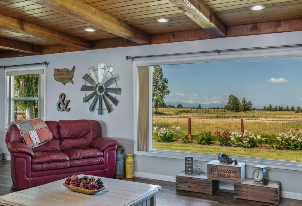
• Cascade Mountain Views from country home in the heart of Central Oregon.
• Property is 35 acres with 32.79 acres of COID water rights, pond, fenced, cross fenced and corrals.
• Ranch style home is updated throughout, 2166 sq ft, 3 bedrooms, 2 bathrooms, single level, dining area, large kitchen, office and open floorplan. Built in 1968, but updated throughout in the last 5 years
• Living room has beautiful views and wood burning fireplace.
• Family room includes a juniper bar and wood burning fireplace.
• Forced air electric heat with heat pump and A/C
• Landscaped yard, garden, greenhouse and chicken coop.
• Two car garage with storage and room
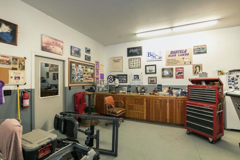
• Shop with workbench, storage area and/office.
• Red Barn with loft area and power.
• Equipment shed and full RV hookup.
• Located approximately 10 minutes to Redmond or Prineville. This property is well maintained and ready for livestock
Irrigation: Central Oregon Irrigation District 32.79 acres $1,699.40
Flood Irrigation with Pond. Delivered 24/7
Domestic Water: Private Well
Utilities: Pacific Power Company 12 month High: $325./month Low $165./month
Average $245./month
Taxes: 2022 Tax Year $3,788.16 Property is Farm Tax Deferral
Zoning: EFU3 Exclusive Farm Use
Price: $$1,295,000
Shown By Appointment Only
MLS 220167101
www.5624reif-powellbutteoregon.com
All information Provided by Cascade Sotheby’s International Realty and Agents is deemed reliable but not guaranteed, Buyer is responsible for any/all due diligence. | 541-923-1376 | www.desertvalleygroup.com
WELL I.D. LABEL# L START CARD # Owner Well I.D. First Name Address Zip (1) LAND OWNER New Well Deepening Abandonment(complete 5a) Conversion (3) DRILL METHOD Rotary Air Rotary Mud Cable Auger Cable Mud Other Reverse Rotary (4) PROPOSED USE Domestic Community Industrial/ Commericial Irrigation Livestock Dewatering State City STATE OF OREGON WATER SUPPLY WELL REPORT (as required by ORS 537.765 & OAR 690-205-0210) Thermal Injection Other (5) BORE HOLE CONSTRUCTION Depth of Completed Well ft. Explosives used: Yes Type Amount SEAL Material From To Amt Other Backfill placed from ft. to ft. Material Filter pack from ft. to ft. Material BORE HOLE (Attach copy) Dia From To Special Standard (6) CASING/LINER Dia Shoe Inside Outside Location of shoe(s) From To Gauge Stl Plstc Wld Thrd Casing Liner (7) PERFORATIONS/SCREENS Method Type Material Scrn/slot width To From # of slots Tele/ pipe size Casing/ Liner Dia (8) WELL TESTS: Minimum testing time is 1 hour Yield gal/min Drawdown Drill stem/Pump depth Duration (hr) Temperature °F Lab analysis Water quality concerns? Yes From Yes (describe below) To Description
LOCATION OF WELL (legal description) Tax Lot Lot Twp Range E/W WM Sec 1/4 1/4 Lat ° ' " or DMS or DD Long ° ' " or DMS or DD County N/S of the (10) STATIC WATER LEVEL WATER BEARING ZONES From To Est Flow SWL(psi) SWL Date (11) WELL LOG Ground Elevation Material To Completed Date Started (unbonded) Water Well Constructor Certification I certify that the work I performed on the construction, deepening, alteration, or abandonment of this well is in compliance with Oregon water supply well construction standards. Materials used and information reported above are true to the best of my knowledge and belief. License Number Date Signed (bonded) Water Well Constructor Certification ORIGINAL - WATER RESOURCES DEPARTMENT THIS REPORT MUST BE SUBMITTED TO THE WATER RESOURCES DEPARTMENT WITHIN 30 DAYS OF COMPLETION OF WORK Depth water was first found Temp casing From To Screen Dia Other Tax Map Number I accept responsibility for the construction, deepening, alteration, or abandonment work performed on this well during the construction dates reported above. All work performed during this time is in compliance with Oregon water supply well construction standards. This report is true to the best of my knowledge and belief. License Number Date Signed Existing Well / Pre-Alteration Completed Well From Company Last Name E D C B A Method How was seal placed: Perf/ Screen + Date SWL(psi) By Amount Units sacks/ lbs Slot length Perforations Screens SWL(ft) + SWL(ft) + Size Contact Info (optional) Flowing Artesian? (2a) PRE-ALTERATION Alteration (complete 2a & 10) (2) TYPE OF WORK To sacks/lbs Amt From Material (5a) ABANDONMENT USING UNHYDRATED BENTONITE Proposed Amount From + Dia TDS amount Casing: Seal: ORIGINAL LOG # Actual Amount + Yes Street address of well Nearest address Pump Bailer Air Flowing Artesian Dry Hole? Form Version: Thrd Wld Plstc Stl Gauge To Calculated Calculated Page 1 of 2 138712 1048101 RICHARD BARTELS 5624 SW REIF RD POWELL BUTTE OR 97753 470.00 68 400.00 400 7/14/2020 7/13/2020 7/14/2020 1255 7/26/2020 1970 7/26/2020 54908 CROO 7/26/2020 NEIL FAGEN (E-filed) WILLIAM AIKEN (E-filed) 541-548-1245 118 ppm 8 1.5 19.5 .250 6 8 470 .188 Perf Liner 6 430 470 .125 3 400 FACTORY CUT 1 8 10 107 111 118 120 134 140 158 269 311 360 430 440 452 455 470 480 470 8 10 107 111 118 120 134 140 158 269 311 360 430 440 455 0 1 452 Top soil Lava rock Broken Lava lava rock Broken lava Lava rock Crevices Lava rock Creves lost retrun Lava rock Brown SS - Tuff Brown SS - Tuff Lava rock lava rock Crevices soft lost returns lava rock soft lava midd lava rock BENTONITE DRY CROOK 15.00 S 14.00 E 22 NE SE 900 44.25191564 -121.02919989 5624 SW REIF RD 25 475 1 7/14/2020 400 480 25 400 12 0 19.5 8 19.5 480 Bentonite 0 19.5 13 S 11.06
(9)
of Hole 54908 CROO 7/26/2020 WATER SUPPLY WELL REPORT - Map with location identified must be attached and shall include an approximate scale and north arrow Page 2 of 2
Map
Bartels, Richard/Catherine 4599 $1,699.40 Last Assessment Amount: Last Assessment Date: 01/17/2023 Current Balance: $0.00
Taxlot Inquiry Central Oregon Irrigation District 5/23/2023 12:38 pm Beat Acreage Division DistrictText Division 5 32.790 CO4 County Tax Map Nbr Acreage County Name Address1 POWELL BUTTE, OR 97753 1514220000900 Crook 32.790 5624 SW REIF RD 32.790 Acreage Transfer TRSQ Lot Usage Headgate Quit Rot# Petition Claim Lease Instream 151422NESE 00900 Irrigation L-10 Acreage: Off Lands: On Lands: Available: 32.790 32.790 Beneficial Use: 2022 Partial - - 2021 Partial 2020 - Partial 2019 Partial - 2018 - Partial 2017 PartialPage 1 of 1
Patron
LLAT L1 1 L-10 L-12 L-11 0 9 a c 31 89 ac R E I F BOZARTH Date: 5/23/2023 User Name: GISTECH PROJECTION COORDINATE SYSTEM: NAD 1983 StatePlane Oregon South FIPS 3602 INTL Feet 1 inch = 197 feet LEGEND STREETS ACRES IRRIGATED LANDS OPEN CANAL PIPED TAXLOTS ³ Document Path: C:\Users\GIStech\Desktop\BASEMAP 2023v2 mxd DISCLAIM ER: THIS M AP IS FOR REFERENCE PURP OSES ONLY COID M AKES NO GUARANTEE S TO T HE ACCURACY OF THIS M AP OR ITS AS SOCAITED GIS DATA SHOWN HEREIN COID IS IN NO WAY RESPONSIBLE FOR THE USAGE OF ANY DATA OR INORMATION AS SOCIATED WITH OR SHOWN ON THIS M AP PATRON INFORMATION NAME: Taxlot(s): 1514220000900 COID WATER RIGHTS MAP 2022 A ERIAL IM AGE
Crook County Property Summary Report
The information and maps presented in this report are provided for your convenience. Every reasonable effort has been made to assure the accuracy of the data and associated maps. Crook County makes no warranty, representation or guarantee as to the content, sequence, accuracy, timeliness or completeness of any of the data provided herein. Crook County explicitly disclaims any representations and warranties, including, without limitation, the implied warranties of merchantability and fitness for a particular purpose. Crook County shall assume no liability for any errors, omissions, or inaccuracies in the information provided regardless of how caused. Crook County assumes no liability for any decisions made or actions taken or not taken by the user of this information or data furnished hereunder.
Report Date: 5/23/2023 11:18:07 AM BARTELS RICHARD & CATHERINE 5624 SW REIF RD POWELL BUTTE, OR 97753-1832 Account Information Ownership Mailing Address: Map and Taxlot: Account: Situs Address: Mailing Name: Tax Status: 15142200-00900-933 933 5624 SW REIF RD, POWELL BUTTE OR 97753 BARTELS RICHARD & CATHERINE Taxable Assessor Acres: Property Taxes Assessment Tax Code Area: Current Tax Year: 0021 2022 35.32 Valuation $44,050 $516,370 Land Structures Total $560,420 Real Market Values as of Jan. 1, 2023 $289,970 $312,550 Maximum Assessed Assessed Value Veterans Exemption $0.00 Current Assessed Values: Account Summary Property Class: 551 Warnings, Notations, and Special Assessments Subdivision: Block: Lot: Assessor's Office Notations Code Description Remarks 501 Potential Additional Tax Liability
Disclaimer 2012 - 2013 2013 - 2014 2014 - 2015 2015 - 2016 2016 - 2017 Real Market Value - Land $34,710 $33,860 $38,040 $39,510 $41,000 Real Market Value - Structures $191,940 $228,450 $247,450 $262,340 $266,140 Total Real Market Value $226,650 $262,310 $285,490 $301,850 $307,140 Maximum Assessed Value $236,683 $236,683 $227,578 $235,780 $242,853 Total Assessed Value $222,050 $255,033 $262,563 $255,000 $262,503 Exemption Value $0 $0 $0 $0 $0 Valuation History All values are as of January 1 of each year. Tax year is July 1st through June 30th of each year. Property Information Report, page 1
2017 - 2018 2018 - 2019 2019 - 2020 2020 - 2021 2021 - 2022 2022 - 2023 $42,470 $43,540 $44,050 $44,050 $44,050 $44,050 $272,520 $304,860 $314,580 $328,470 $394,170 $516,370 $314,990 $348,400 $358,630 $372,520 $438,220 $560,420 $250,139 $257,643 $265,372 $273,333 $281,530 $289,970 $270,259 $278,223 $286,442 $294,873 $303,580 $312,550 $0 $0 $0 $0 $0 $0 Property Information Report, page 2 (For Report Disclaimer see page 1)
Tax Payment History
Year Date Due Transaction Type Transaction Date As Of Date Amount Received Tax Due Discount Amount Interest Charged Refund Interest 2022 11/15/2022 PAYMENT 11/10/2022 11/10/2022 $3,674.52 ($3,788.16) $113.64 $0.00 $0.00 2022 11/15/2022 IMPOSED 10/12/2022 11/15/2022 $0.00 $3,788.16 $0.00 $0.00 $0.00 Total: $0.00 2021 11/15/2021 PAYMENT 11/08/2021 11/08/2021 $3,675.93 ($3,789.62) $113.69 $0.00 $0.00 2021 11/15/2021 IMPOSED 10/12/2021 11/15/2021 $0.00 $3,789.62 $0.00 $0.00 $0.00 Total: $0.00 2020 11/15/2020 PAYMENT 11/13/2020 11/15/2020 $3,575.88 ($3,686.47) $110.59 $0.00 $0.00 2020 11/15/2020 IMPOSED 10/16/2020 11/15/2020 $0.00 $3,686.47 $0.00 $0.00 $0.00 Total: $0.00 2019 11/15/2019 IMPOSED 11/15/2019 11/15/2019 $0.00 $3,557.95 $0.00 $0.00 $0.00 2019 11/15/2019 PAYMENT 11/14/2019 11/15/2019 $3,451.21 ($3,557.95) $106.74 $0.00 $0.00 Total: $0.00 2018 11/15/2018 IMPOSED 11/15/2018 11/15/2018 $0.00 $3,469.75 $0.00 $0.00 $0.00 2018 11/15/2018 PAYMENT 11/14/2018 11/15/2018 $3,365.66 ($3,469.75) $104.09 $0.00 $0.00 Total: $0.00 2017 11/15/2017 IMPOSED 11/15/2017 11/15/2017 $0.00 $3,418.99 $0.00 $0.00 $0.00 2017 11/15/2017 PAYMENT 11/14/2017 11/15/2017 $3,316.42 ($3,418.99) $102.57 $0.00 $0.00 Total: $0.00 2016 11/15/2016 PAYMENT 11/15/2016 11/15/2016 $3,165.54 ($3,263.44) $97.90 $0.00 $0.00 2016 11/15/2016 IMPOSED 11/15/2016 11/15/2016 $0.00 $3,263.44 $0.00 $0.00 $0.00 Total: $0.00 2015 11/15/2015 IMPOSED 11/15/2015 11/15/2015 $0.00 $3,122.99 $0.00 $0.00 $0.00 2015 11/15/2015 PAYMENT 11/05/2015 11/15/2015 $3,029.30 ($3,122.99) $93.69 $0.00 $0.00 Total: $0.00 2014 11/15/2014 IMPOSED 11/15/2014 11/15/2014 $0.00 $3,154.51 $0.00 $0.00 $0.00 2014 11/15/2014 PAYMENT 11/06/2014 11/15/2014 $3,059.87 ($3,154.51) $94.64 $0.00 $0.00 Total: $0.00
Property Information Report, page 3 (For Report Disclaimer see page 1)
Sales History
Year Date Due Transaction Type Transaction Date As Of Date Amount Received Tax Due Discount Amount Interest Charged Refund Interest 2013 11/15/2013 IMPOSED 11/15/2013 11/15/2013 $0.00 $3,077.05 $0.00 $0.00 $0.00 2013 11/15/2013 PAYMENT 11/05/2013 11/15/2013 $2,984.74 ($3,077.05) $92.31 $0.00 $0.00 Total: $0.00 2012 11/15/2012 IMPOSED 11/15/2012 11/15/2012 $0.00 $2,672.94 $0.00 $0.00 $0.00 2012 11/15/2012 PAYMENT 11/13/2012 11/15/2012 $2,592.75 ($2,672.94) $80.19 $0.00 $0.00 Total: $0.00 2011 11/15/2011 IMPOSED 11/15/2011 11/15/2011 $0.00 $2,576.93 $0.00 $0.00 $0.00 2011 11/15/2011 PAYMENT 11/07/2011 11/15/2011 $2,499.62 ($2,576.93) $77.31 $0.00 $0.00 Total: $0.00 2010 11/15/2010 IMPOSED 11/15/2010 11/15/2010 $0.00 $2,910.00 $0.00 $0.00 $0.00 2010 11/15/2010 PAYMENT 11/03/2010 11/15/2010 $2,822.70 ($2,910.00) $87.30 $0.00 $0.00 Total: $0.00 2009 11/15/2009 IMPOSED 11/15/2009 11/15/2009 $0.00 $2,724.52 $0.00 $0.00 $0.00 2009 11/15/2009 PAYMENT 11/12/2009 11/15/2009 $2,642.78 ($2,724.52) $81.74 $0.00 $0.00 Total: $0.00 2008 11/15/2008 IMPOSED 11/15/2008 11/15/2008 $0.00 $2,962.93 $0.00 $0.00 $0.00 2008 11/15/2008 PAYMENT 11/05/2008 11/15/2008 $2,874.04 ($2,962.93) $88.89 $0.00 $0.00 Total: $0.00 2007 11/15/2007 IMPOSED 11/15/2007 11/15/2007 $0.00 $2,870.51 $0.00 $0.00 $0.00 2007 11/15/2007 PAYMENT 11/02/2007 11/15/2007 $2,784.39 ($2,870.51) $86.12 $0.00 $0.00 Total: $0.00 2006 11/15/2006 IMPOSED 11/15/2006 11/15/2006 $0.00 $2,783.78 $0.00 $0.00 $0.00 2006 11/15/2006 PAYMENT 11/03/2006 11/15/2006 $2,700.27 ($2,783.78) $83.51 $0.00 $0.00 Total: $0.00 2005 11/15/2005 IMPOSED 11/15/2005 11/15/2005 $0.00 $2,352.77 $0.00 $0.00 $0.00 2005 11/15/2005 PAYMENT 10/28/2005 11/15/2005 $2,282.19 ($2,352.77) $70.58 $0.00 $0.00 Total: $0.00 2004 11/15/2004 PAYMENT 11/18/2004 11/15/2004 $2,218.05 ($2,286.65) $68.60 $0.00 $0.00 2004 11/15/2004 IMPOSED 11/15/2004 11/15/2004 $0.00 $2,286.65 $0.00 $0.00 $0.00 Total: $0.00 2003 11/15/2003 IMPOSED 11/15/2003 11/15/2003 $0.00 $2,368.61 $0.00 $0.00 $0.00 2003 11/15/2003 PAYMENT 11/07/2003 11/15/2003 $2,297.55 ($2,368.61) $71.06 $0.00 $0.00 Total: $0.00 2002 11/15/2002 IMPOSED 11/15/2002 11/15/2002 $0.00 $2,324.58 $0.00 $0.00 $0.00 2002 11/15/2002 PAYMENT 11/06/2002 11/15/2002 $2,254.84 ($2,324.58) $69.74 $0.00 $0.00 Total: $0.00 2001 11/15/2001 PAYMENT 11/19/2001 11/15/2001 $2,216.26 ($2,284.80) $68.54 $0.00 $0.00 2001 11/15/2001 IMPOSED 11/15/2001 11/15/2001 $0.00 $2,284.80 $0.00 $0.00 $0.00 Total: $0.00 2000 11/15/2000 IMPOSED 11/15/2000 11/15/2000 $0.00 $1,799.30 $0.00 $0.00 $0.00 2000 11/15/2000 PAYMENT 11/06/2000 11/15/2000 $1,745.32 ($1,799.30) $53.98 $0.00 $0.00 Total: $0.00
Property Information Report, page 4 (For Report Disclaimer see page 1)
Sale Date Seller Buyer Sale Amount Sale Type Recording 07/01/2011 LEWIS DARRYL C KASTOR FAMILY JOLON LTD PARTNERSHIP $475,000 2011-247392 03/20/1991 UNDETERMINED GRANTOR NAME $150,000 WARRANTY DEED 1994-098761 12/15/2015 KASTOR FAMILY JOLON LTD PARTNERSHIP BARTELS RICHARD & CATHERINE $548,000 2015-271757 Stat Class/Description Improvement Description Code Area Year Built Eff Year Built Total Sq Ft FARM BLDG - : LOFT BARN LOFT BARN 0021 0 1970 1596 Stat Class/Description Improvement Description Code Area Year Built Eff Year Built Total Sq Ft FARM BLDG - : MACHINE SHED MACHINE SHED 0021 1994 1994 1440 Stat Class/Description Improvement Description Code Area Year Built Eff Year Built Total Sq Ft FARM BLDG - : GP BUILDING GP BUILDING 0021 1999 1999 1296 Stat Class/Description Improvement Description Code Area Year Built Eff Year Built Total Sq Ft RESIDENCE - : Residential Other Improvements Residential Other Improvements 0021 0 1982 0 Stat Class/Description Improvement Description Code Area Year Built Eff Year Built Total Sq Ft RESIDENCE - : Residential Other Improvements Residential Other Improvements 0021 0 1999 0 Stat Class/Description Improvement Description Code Area Year Built Eff Year Built Total Sq Ft RESIDENCE - : Residential Other Improvements Residential Other Improvements 0021 0 2000 0 Stat Class/Description Improvement Description Code Area Year Built Eff Year Built Total Sq Ft RESIDENCE - : Residential Other Improvements Residential Other Improvements 0021 0 1990 0 Stat Class/Description Improvement Description Code Area Year Built Eff Year Built Total Sq Ft RESIDENCE - : RES One story RES One story 0021 1968 1990 2166
Land Description Acres Land Classification OSD 0.00 SA OSD Farm Use Zoned 9.22 022 OSD 0.00 YARD - AVERAGE Farm Use Zoned 3.32 026 Farm Use Zoned 16.21 023 Farm Use Zoned 5.57 024 Property Information Report, page 5 (For Report Disclaimer see page 1)
Structures Land Characteristics
Related Accounts
Related accounts apply to a property that may be on one map and tax lot but due to billing have more than one account. This occurs when a property is in multiple tax code areas. In other cases there may be business personal property or a manufactured home on this property that is not in the same ownership as the land.
No Related Accounts found.
Ownership
Market 1.00 02SHS
Name Type Name Ownership Type Percentage OWNER BARTELS CATHERINE A , 100.00% OWNER BARTELS RICHARD W , 100.00% Taxpayer BARTELS RICHARD & CATHERINE, 100.00% 300.00% Property Information Report, page 6 (For Report Disclaimer see page 1)
MAP: JULY 1, 2022 TO JUNE 30, 2023 CROOK COUNTY TAX COLLECTOR 200 NE 2nd St Prineville, OR 97754 933 ACCOUNT NO: BARTELS RICHARD & CATHERINE 5624 SW REIF RD POWELL BUTTE OR 97753-1832 5624 SW REIF RD POWELL BUTTE SITUS: 151422-00-00900 CODE: 0021 VALUES: REAL MARKET (RMV) LAND STRUCTURES TOTAL RMV TOTAL ASSESSED VALUE NET TAXABLE: TOTAL PROPERTY TAX: LAST YEAR THIS YEAR 44,050 394,170 438,220 44,050 516,370 560,420 303,580 303,580 3,789.62 312,550 312,550 3,788.16 THIS IS NOT A TAX BILL IF... Your mortgage company is reponsible for 3,674.52 TOTAL DUE (After Discount ) 3,788.16 - 2022 2023 TAX ( Before Discount ) PROPERTY DESCRIPTION 2023 - 2022 CURRENT TAX BY DISTRICT paying for taxes. Keep this statement for your records. STERLING SAVINGS ASSN Crook County Website - www.co.crook.or.us 1/3 PAYMENT 50.51 Nov 15, 2022 Date Due Amount Discount Allowed (See back of statement for instructions) 2,474.93 PAYMENT OPTIONS 1,262.72 113.64 Nov 15, 2022 Nov 15, 2022 2/3 PAYMENT 3,674.52 FULL PAYMENT No Discount .... 3% Discount .... 2% Discount .... TAX PAYMENT OPTIONS Tax Collector (541) 447-6554 or Assessor (541) 447-4133 **POTENTIAL ADDITIONAL TAX LIABILITY** ACRES: 35.32 TOTAL SAV 438,220 560,420 REAL PROPERTY TAX STATEMENT Tear Here Tear Here *COURTESY STATEMENT IF LENDER IS SCHEDULED TO PAY. CALL LENDER TO VERIFY IF NECESSARY* ACCOUNT NO. 933 PAYMENT OPTIONS Discount Date Due Amount Full Payment Enclosed or 2/3 Payment Enclosed or 1/3 Payment Enclosed 3% 2% 0% 11/15/22 11/15/22 11/15/22 1,262.72 2,474.93 3,674.52 MAILING ADDRESS CHANGES ON BACK Enter Payment Amount $ BARTELS RICHARD & CATHERINE 5624 SW REIF RD POWELL BUTTE OR 97753-1832 MAKE PAYMENT TO: CROOK COUNTY 200 NE 2nd St Prineville, OR 97754 07100000009330000126272000024749300003674527 CROOK COUNTY TAX COLLECTOR 2022 - 2023 PROPERTY TAXES DISCOUNT IS LOST & INTEREST APPLIES AFTER DUE DATE TAX COLLECTOR HIGH DESERT ESD 30.13 CROOK COUNTY SCHOOL DIST 1,495.74 CENTRAL OR COMM COLLEGE 193.91 EDUCATION TOTAL: 1,719.78 CROOK COUNTY GENERAL FUND 1,209.63 AG EXTENSION SERVICE 37.72 CROOK CO HISTORICAL FUND 18.75 CROOK CO FIRE & RESCUE 496.95 CEMETERY DISTRICT 31.07 GENERAL GOVT TOTAL: 1,794.12 CC JAIL BOND 62.26 CC SCHOOL BOND 188.03 COCC BOND & INTEREST 23.97 BONDS - OTHER TOTAL: 274.26 Property Information Report, page 7 (For Report Disclaimer see page 1)
Bartels, Richard/Catherine 4599 $1,699.40 Last Assessment Amount: Last Assessment Date: 01/17/2023 Current Balance: $0.00
Taxlot Inquiry Central Oregon Irrigation District 5/23/2023 12:38 pm Beat Acreage Division DistrictText Division 5 32.790 CO4 County Tax Map Nbr Acreage County Name Address1 POWELL BUTTE, OR 97753 1514220000900 Crook 32.790 5624 SW REIF RD 32.790 Acreage Transfer TRSQ Lot Usage Headgate Quit Rot# Petition Claim Lease Instream 151422NESE 00900 Irrigation L-10 Acreage: Off Lands: On Lands: Available: 32.790 32.790 Beneficial Use: 2022 Partial - - 2021 Partial 2020 - Partial 2019 Partial - 2018 - Partial 2017 PartialPage 1 of 1
Patron
Sales History
Year Date Due Transaction Type Transaction Date As Of Date Amount Received Tax Due Discount Amount Interest Charged Refund Interest 2013 11/15/2013 IMPOSED 11/15/2013 11/15/2013 $0.00 $3,077.05 $0.00 $0.00 $0.00 2013 11/15/2013 PAYMENT 11/05/2013 11/15/2013 $2,984.74 ($3,077.05) $92.31 $0.00 $0.00 Total: $0.00 2012 11/15/2012 IMPOSED 11/15/2012 11/15/2012 $0.00 $2,672.94 $0.00 $0.00 $0.00 2012 11/15/2012 PAYMENT 11/13/2012 11/15/2012 $2,592.75 ($2,672.94) $80.19 $0.00 $0.00 Total: $0.00 2011 11/15/2011 IMPOSED 11/15/2011 11/15/2011 $0.00 $2,576.93 $0.00 $0.00 $0.00 2011 11/15/2011 PAYMENT 11/07/2011 11/15/2011 $2,499.62 ($2,576.93) $77.31 $0.00 $0.00 Total: $0.00 2010 11/15/2010 IMPOSED 11/15/2010 11/15/2010 $0.00 $2,910.00 $0.00 $0.00 $0.00 2010 11/15/2010 PAYMENT 11/03/2010 11/15/2010 $2,822.70 ($2,910.00) $87.30 $0.00 $0.00 Total: $0.00 2009 11/15/2009 IMPOSED 11/15/2009 11/15/2009 $0.00 $2,724.52 $0.00 $0.00 $0.00 2009 11/15/2009 PAYMENT 11/12/2009 11/15/2009 $2,642.78 ($2,724.52) $81.74 $0.00 $0.00 Total: $0.00 2008 11/15/2008 IMPOSED 11/15/2008 11/15/2008 $0.00 $2,962.93 $0.00 $0.00 $0.00 2008 11/15/2008 PAYMENT 11/05/2008 11/15/2008 $2,874.04 ($2,962.93) $88.89 $0.00 $0.00 Total: $0.00 2007 11/15/2007 IMPOSED 11/15/2007 11/15/2007 $0.00 $2,870.51 $0.00 $0.00 $0.00 2007 11/15/2007 PAYMENT 11/02/2007 11/15/2007 $2,784.39 ($2,870.51) $86.12 $0.00 $0.00 Total: $0.00 2006 11/15/2006 IMPOSED 11/15/2006 11/15/2006 $0.00 $2,783.78 $0.00 $0.00 $0.00 2006 11/15/2006 PAYMENT 11/03/2006 11/15/2006 $2,700.27 ($2,783.78) $83.51 $0.00 $0.00 Total: $0.00 2005 11/15/2005 IMPOSED 11/15/2005 11/15/2005 $0.00 $2,352.77 $0.00 $0.00 $0.00 2005 11/15/2005 PAYMENT 10/28/2005 11/15/2005 $2,282.19 ($2,352.77) $70.58 $0.00 $0.00 Total: $0.00 2004 11/15/2004 PAYMENT 11/18/2004 11/15/2004 $2,218.05 ($2,286.65) $68.60 $0.00 $0.00 2004 11/15/2004 IMPOSED 11/15/2004 11/15/2004 $0.00 $2,286.65 $0.00 $0.00 $0.00 Total: $0.00 2003 11/15/2003 IMPOSED 11/15/2003 11/15/2003 $0.00 $2,368.61 $0.00 $0.00 $0.00 2003 11/15/2003 PAYMENT 11/07/2003 11/15/2003 $2,297.55 ($2,368.61) $71.06 $0.00 $0.00 Total: $0.00 2002 11/15/2002 IMPOSED 11/15/2002 11/15/2002 $0.00 $2,324.58 $0.00 $0.00 $0.00 2002 11/15/2002 PAYMENT 11/06/2002 11/15/2002 $2,254.84 ($2,324.58) $69.74 $0.00 $0.00 Total: $0.00 2001 11/15/2001 PAYMENT 11/19/2001 11/15/2001 $2,216.26 ($2,284.80) $68.54 $0.00 $0.00 2001 11/15/2001 IMPOSED 11/15/2001 11/15/2001 $0.00 $2,284.80 $0.00 $0.00 $0.00 Total: $0.00 2000 11/15/2000 IMPOSED 11/15/2000 11/15/2000 $0.00 $1,799.30 $0.00 $0.00 $0.00 2000 11/15/2000 PAYMENT 11/06/2000 11/15/2000 $1,745.32 ($1,799.30) $53.98 $0.00 $0.00 Total: $0.00
Property Information Report, page 4 (For Report Disclaimer see page 1)