
Grand County Economic Development discovermoab.com An Introduction to Outdoor Adventures and Activities Available in the Moab Area Hiking • Dinosaur Tracksites • Pet Activities 4-Wheel Drive Trails • Motorcycle Trails Scenic Auto Drives • River Activities Mountain Biking • E-Biking UTV/ATV Trails & Info Movie Sites • Camping Dark Sky Observing Much more! MOAB ADVENTUREOUTDOORGUIDE PROTECT & PRESERVE MOAB


BLM Bureau of Land Management - Moab Field Office
Public Land Agencies
NPS National Park Service
SITLA State School & Institutional Trust Lands Administration
FOREST SRV U. S. Forest Service - Moab Ranger District STATE PK Utah State Parks and Recreation Moab Outdoor Adventure Guide | discovermoab.com
Grand County Economic Development would like to thank all of the agencies and organizations that manage and maintain the spectacular lands surrounding Moab including the Bureau of Land Management, Grand County Trail Mix Committee, Manti-La Sal National Forest Service, National Park Service, Sand Flats Recreation Area, State School & Institutional Trust Lands Administration, State Sovereign Lands, Utah State Parks and Recreation and other agencies and organizations. By following the rules and regulations set forth by these agencies we can all do our best to ensure that these lands will be preserved and protected for future generations to Throughoutenjoy. this guide the following symbols are used to denote the primary land agency that manages the corresponding land/trail:
SAND FLATS Sand Flats Recreation Area

Table of Contents Hiking Trails............................................ 3 Dinosaur Trails & Tracksites ....................... 13 Mountain Bike Trail Systems ...................... 19 E-Bike Information ................................... 23 Scenic Byways ........................................ 27 Dinosaur Diamond Prehistoric Highway ..... 31 Rock Art Auto Tours ................................. 35 Moab Area Movie Locations ..................... 40 Colorado River Activities .......................... 43 Colorado River Sections ........................... 44 Tamarisk Control & Restoration ................. 48 Moab 4-Wheel Drive Trails ........................ 50 Traveling with Pets................................... 54 UTV/ATV Recreation ................................ 57 White Wash Sand Dunes .......................... 60 Moab Area OHV Trail Access ..................... 61 Motorcycle Trail Riding ............................ 67 Moab Area Camping ............................... 73 Southeast Utah’s Dark Skies ...................... 76 Equestrian Trails ...................................... 78 Search and Rescue Advice ........................ 80 Minimum Impact Practices ....................... 82 © 2022 Grand County Economic Development This booklet is presented as a courtesy to locals and area visitors. No warranty, expressed or implied, is made as to the safety or ongoing validity of information listed herein. Grand County, Utah and their agents are not responsible for any liability arising from the use of the information herein. PROTECT & PRESERVE MOAB discovermoab.com The official information source for everything to see and do in the Moab area. discovermoab.com | Moab Outdoor Adventure Guide - 1
Hiking Trails 2 - Moab Outdoor Adventure Guide | discovermoab.com

Pets are allowed on all of the hikes listed below. Please note that Grand County “Animal Care and Control” code does apply: “(1) All dogs must be kept under restraint, and (2) No owner shall fail to exercise proper care and control of his or her animals to prevent them from becoming a public nuisance. In the backcountry a leash is recommended and dogs do need to be under verbal restraint and not chase or harass wildlife.” Please be aware that desert terrain is very hard on dogs’ paws and owners should carry plenty of water for their dog as well as themselves. Pack out all waste and do not leave bags of waste on trails or at trailheads.
The Moab area contains a large number of pet-friendly hiking trails on the public lands surrounding our national parks. (Pets are not allowed on trails within our national parks.) From cool stream-side hikes to spectacular sandstone arches, the Moab area outside of the parks is full of exciting day hikes suitable for the entire family.
Highlights Broad sweeping views and solitude
Trailhead Access is across SR 128 from Hittle Bottom Boat launch. Park at Hittle Bottom. Hittle Bottom is approximately 22 miles from the intersection of US Highway 191 and SR 128.
Moab Outdoor Adventure Guide - 3
2.8 miles round trip; allow 2.5 hours round trip.
Hiking Trails
Description Walk wash bottoms, around boulders and over benches meandering in the Moenkopi and Cutler sandstones. Follow cairns and signs to stay on the trail. The trail ascends 250 feet for that sweeping view of the Colorado River discovermoab.comcorridor.|
Amphitheater Loop BLM Map ID: 1 (Page 2)
Length


On SR 279, 10 miles west of the SR 279/US Highway 191 junction. Description From the Corona Arch Trailhead, follow the trail as it climbs east to a BLM register and across the railroad tracks. After carefully crossing the railroad tracks follow an old eroded road bed through a gap in the slickrock bench above. After reaching the top of the bench, the route follows a trail of cairns (little piles of rock) northeast towards the base of a large sandstone cliff. Follow the base of the cliff east to a safety cable that protects a slightly exposed section of trail. Corona Arch is visible from this point. After the first safety cable, continue to follow the base of the cliff to a second safety cable with steps carved into the sandstone. From the top of the steps continue east, climb a short ladder up over a ledge and follow the cairns up to the top of a large bench. From this point, it is easy to walk along the wide slickrock bench, beneath Bowtie Arch, and on to the base of Corona Arch. Along the way you’ll pass two other arches, Pinto and Bowtie, before reaching unmistakable Corona Arch. The length of this trail and the need to climb ladders and use safety cables are things you need to consider when determining if your child is old enough and fit enough to accomplish. Children as young as five have done this trail without difficulty, while grown adults have chosen to not go up the second safety cable section. Dogs are allowed on BLM trails; however, due to obstacles, this trail may be better suited to more agile ani mals or smaller dogs which can be lifted. Visitors are asked to respect other users, the natural beauty of the area, and this iconic landmark, and not engage in roped activities near Corona Arch. In July 2017, following several years of public outreach and environmental reviews, a rule was published in the Federal Register restricting Corona Arch from roped activities. Due to lack of shade, consider hiking this trail early morning or early evening. Restrooms are available at the Gold Bar Campground across the road from the trailhead.
Length 1.5 miles to Corona Arch; allow 2 hours round trip.
4 - Moab Outdoor Adventure Guide | discovermoab.com
Trailhead
Highlights
Corona Arch (140 by 105 foot opening) and adjacent Bow Tie Arch; also views of the Colorado River and a large slickrock canyon. The Corona Arch Trail was designated as a National Recreation Trail on May 30, 2018.
Corona Arch Trail BLM Map ID: 2 (Page 2)

The hiking trail leads to an elongated arch, locally called a “tunnel”.
Trailhead
Description This hike visits Dellenbaugh Tunnel, an elongated arch on the rim above Spring Canyon.
Description From the parking lot (please sign in at register box), the trail goes down a short set of steps and then runs to the left out onto a small slickrock ridge. Follow the ridge away from the main cliffs until just after it narrows and then go left down into the ravine through a small cut on the left side of the ridge. From the bottom of the ravine, the trail heads steeply up and then begins to wind directly beneath the Fisher Towers. After swinging around the largest tower, The Titan, the trail ascends and ends on a ridge with a panoramic view. The Fisher Towers are composed of Moenkopi and Cutler sandstones and have eroded into many fantastical shapes. Climbers occasionally scale these mudstone towers. (Be cautious of hiking directly below a climber!) Note: This trail has a western exposure and can be exceptionally hot on summer afternoons. Mountain bikes are not allowed on this trail.
discovermoab.com | Moab Outdoor Adventure Guide - 5
Fisher Towers Trail BLM Map ID: 4 (Page 2)
Close up views of the Fisher Towers and Onion Creek area. Distant views include the Colorado River, Castle Valley, Fisher Mesa, and the Book Cliffs. Length 2.2 miles one-way to ridge at trail’s end; allow 4 hours round trip. Trailhead Off SR 128. At 21 miles east of the SR 128/US Highway 191 junction, turn right and go 2.2 miles on an improved dirt road to a parking lot.
Highlights
First you follow a rolling ridge of beige slickrock across open desert, then you contour along a rim with interesting down-canyon views. Eventually you meet up with a jeep road at the entrance to the tunnel.
Highlights
Dellenbaugh Tunnel BLM Map ID: 3 (Page 2)
Length 3 miles round trip; allow 3 hours round trip.
Travel north from Moab on US Highway 191. Proceed west on SR 313 for 8 miles. Turn right on the Dubinky Well Road and go north for approximately five miles. Turn left at the Spring Canyon Point Road (just before the Dubinky windmill). Go west on this road for about one mile to the base of the large Tombstone (Needle) Rock monolith. Turn left on a dirt road at this monolith and it is less than a mile to a parking area.

Highlights
Highlights Good views of the Moab Valley and Behind the Rocks Wilderness Study Area. Trail connects with the southern end of the Moab Rim 4-wheel drive trail. Length 2 miles to pass at north end of Hidden Valley; allow 3 hours round trip.
Length 2 miles to Morning Glory Bridge; allow 4 hours round trip.
Description From the parking area, follow the trail up to the base of the Moab Rim and then ascend a series of steep switchbacks. At the top of the switchbacks, the trial heads north and enters Hidden Valley - a broad shelf between the top of the Moab Rim and Spanish Valley. Follow the trail to a low rise that separates the two halves of Hidden Valley and continue along through the northern section to a point where the trail swings to the left and goes over a low pass. At the pass, you will be rewarded with a view of the large sandstone fins of the Behind the Rocks area. The trail continues down the west side of the pass for about 1/3 mile where it meets the Moab Rim 4-wheel-drive trail. The hike may be extended to the Colorado River by following the Moab Rim four-wheel-drive trail to its starting point.
Trailhead Drive 3 miles south from Moab on US Highway 191 and turn right onto Angel Rock Road. After two blocks, turn right onto Rimrock Road and drive to parking area.
Perennial clear stream in scenic canyon and Morning Glory Natural Bridge, which is 243 feet long and the sixth-longest natural rock span in the United States.
Hidden Valley Trail BLM Map ID: 6 (Page 2)
(Note: During late summer afternoons this trail is largely in the shade of higher cliffs.)
Highlights Free-flowing stream with cottonwood trees and pools. A large arch is located high on the right-hand side of the canyon about 1/2 mile from the trailhead. 6 - Moab Outdoor Adventure Guide | discovermoab.com
Grandstaff Canyon Trail BLM Map ID: 5 (Page 2)
Hunter Canyon BLM Map ID: 7 (Page 2)
Trailhead On SR 128, three miles east of junction with US Highway 191. Description From the parking area next to SR 128, follow the trail that starts on the left side of the stream. Keep going upstream for about 1.5 miles. Morning Glory Natural Bridge is located at the end of the second side canyon on the right. Follow the trail to where it crosses the stream at the mouth of the side canyon. Cross the stream, then follow the trail up a steep slope into the side canyon. Morning Glory Bridge is located at the end of the trail about 1/2 mile up the canyon from the stream. Do not touch the poison ivy that grows below the pool under the bridge! Poison ivy has shiny leaves with serrated edges in clusters of 3.
The trail climbs a small mesa and circles the mesa top, offering scenic views of the Grandstaff and Mill Creek Canyons, the Moab and Porcupine Rims, the La Sal Mountain range and the Colorado River channel. The trail is “lollipop” in shape. The “stem” section 1/2 mile in length, begins at the trailhead, travels to the first overlook, backtracks slightly, then climbs westerly to the top of a small mesa where the loop section begins. The loop is about a mile in length and contours with the edge of the mesa over level dirt and slickrock. Sections of the trail follow along steep cliff edges. Use caution! Follow trail markers to avoid getting lost and damaging resources. Several openings on the rim provide panoramic views of the features listed above. After circling the mesa top, the trail rejoins the “stem” route back to the parking area. Lake
Juniper Trail SAND FLATS BLM Map ID: 8 (Page 2)
The trailhead is located in the Sand Flats Recreation Area. It is 6.3 miles passed the entrance station on the north side of the Sand Flats road. A parking area is provided. The trail is also accessible to campers in the Juniper campground. This is a fee area.
Highlights Sweeping views of the Sand Flats Recreation Area and more.
Ken’s
Circumnavigate the reservoir, walk to Faux Falls, and enjoy the Ken’s Lake Rock Loop nature trail. Faux Falls is created by a diversion, piping water from Mill Creek to fill up the reservoir.
Description
Highlights
Trailhead
Trailhead
Description From the parking area at the mouth of the canyon, follow the trail about two miles up the canyon until the route gets blocked by brush.
Trails BLM Map ID: 9 (Page 2)
On Kane Creek Boulevard 7.5 miles west of its intersection with US Highway 191. Canyon is on the left, one mile beyond the switchbacks.
Family friendly short jaunts near water sources for more nature.
Length Total of 3 miles; allow 2 hours round trip.
Trailhead
Length 2 miles one-way; allow 4 hours round trip.
Length 2 miles round trip; allow 3 hours round trip.
There are various locations around the Ken’s Lake Campground. Ken’s Lake is ten miles south of downtown Moab. Turn off of US Highway 191 seven miles south of Moab onto discovermoab.com
| Moab Outdoor Adventure Guide - 7

Highlights Great views of Behind the Rocks, La Sal Mountains, rock art near the beginning of the trail, and 60 foot Longbow Arch. Do not touch rock art as oil on your skin causes damage.
Length 1.2 miles one-way from the parking lot to base of arch; allow 3 hours round trip.
Length 3 miles to connection with Hidden Valley Trail; allow 2 hours round trip. Trailhead
The trail climbs moderately after leaving the parking lot, passing several spurs to rock art panels, then climbs steeply for a short distance on slickrock. It levels out 200 feet above the parking lot. The trail then skirts the 4-wheel drive route and enters a broad canyon. Near the end of the canyon the trail passes through a narrow side canyon where the arch is high on the left wall. A primitive trail continues up below the arch. Return via same route.
8 - Moab Outdoor Adventure Guide | discovermoab.com
Longbow Arch Trail BLM Map ID: 10 (Page 2)
Highlights Good views of the Colorado River, Moab Valley, and the Behind the Rocks area.
On Kane Creek Boulevard, 2.6 miles northwest of its intersection with US Highway 191 in Moab.
Old Airport Road. Turn south onto La Sal Mountain Loop Road. Follow the signs to Ken’s Lake on San Juan County Road 175.
The trail begins at the Poison Spider parking area, 5.9 miles from US Highway 191 on SR 279. Trailhead is near restroom.
Trailhead
Description
Route Description
Moab Rim Trail BLM Map ID: 11 (Page 2)
From the parking area, follow the 4-wheel-drive vehicle route up the slickrock ramps of Kayenta sandstone. After about 1.4 miles, the route reaches a viewpoint of the Moab Valley. Follow the vehicle route south and then down through a slickrock area located between two large domes of Navajo sandstone. At the base of the slickrock area, the route continues along a wash bottom and then up a large sand hill. From the top of the sand hill, the route branches twice to the left. The first spur on the left leads to a view point high above Spanish Valley. The second spur route ends after 200 yards at another view point. Ahead to the south, the view is dominated by a long ridge of massive sandstone fins. From the intersection, the main route drops down into a wash and then climbs in an easterly direction to its terminus just below the pass to Hidden Valley. (Note: The Moab Rim Trail is a shared use trail. You may encounter jeeps, mountain bikes, dirt bikes or ATVs on the route.)
The parking lot for the trailhead is 5.9 miles from US Highway 191 on SR 279. The trailhead begins on the Poison Spider Jeep Trail, about 1/4 miles from the parking lot.
Trailhead
Pinto Arch Trail BLM Map ID: 2 (Page
Highlights Views of the Colorado River.
discovermoab.com | Moab Outdoor Adventure Guide - 9
2)
Highlights Although a short trail, hikers are treated with several large alcoves containing hanging gardens, as well as scenic views of the Colorado River coursing its way through the canyon 500 feet below. At the trail’s end you can stand under the attractive Pinto Arch with its 30foot span. The trail can also be combined with the popular Corona Arch Trail.
1.25 miles one-way to overlook of river; allow 2 hours round trip Trailhead
Access to the first trail spur going to Pinto Arch occurs a half mile along the Corona Arch Trail. As it starts, most of the trail is on slickrock rather than sand, before transitioning entirely to slickrock for the last half mile of the hike to the arch. The trail works its way across slickrock toward several large Navajo Sandstone alcoves. As it nears the alcoves the trail makes a short climb to get up to the bench below the alcoves. Then it easily climbs up other stone benches for a couple hundred yards before Pinto Arch comes into view. The rest of the route to the arch is plainly evident. Hikers only interested in going to Pinto Arch will take the same route back to the Corona Arch Trail and parking lot. Alternatively, hikers continuing on to Corona Arch can take a second 0.12 mile spur that rejoins the Corona Arch Trail a tenth of a mile above the first spur. Hikers returning from Corona Arch that wish to continue on to Pinto Arch would also be able to use this spur to connect to the main Pinto Arch Trail. Creating the Pinto Arch Trail as a designated trail creates its own scenic destination, but also offers stronger hikers going to Bow-Tie and Corona Arches an extension to their hike length, and the benefit of seeing a third great arch up close.
Poison Spider Bench BLM Map ID: 12 (Page 2)
Length
The trail is on an old road that has been closed to motorized and mechanized use. The trail is mostly level with one short climb. The trail has great views, especially towards Moab and the La Sal Mountains. Look for an arch on the rim to your right (northeast) near the end of the trail. The trail ends at a viewpoint with good views of the Colorado River.
Description
On SR 279, 10 miles west of the SR 279/US Highway 191 junction. This is the same starting point for the Corona Arch Trail.
Description
Length 2.1 miles roundtrip; 3.3 miles if combined with the Corona Arch Trail.
10 - Moab Outdoor Adventure Guide | discovermoab.com
Trailhead
Highlights
The Red Onion Trail is a primitive hiking loop that connects to the Fisher Towers Trail. The trail is a challenging 2.4 mile loop that winds through narrow washes and canyons with striking views of Fisher Towers, Onion Creek and the Professor Valley. Length 2.4 miles as a loop. 0.2 mile of this loop is on the Fisher Towers Trail.
Red Onion Trail BLM Map ID: 17 (Page 2)
Highlights
Description
Trailhead At Jaycee Park Campground on SR 279, 4.2 miles west of the SR 279/US Highway 191 junction. Description From Jaycee Park Campground, follow the hiking trail up the Colorado River towards the river “portal. “ From the trailside visitor register box, the trail begins its climb to the viewpoint. After several switchbacks, the trail follows a cairned route up “ramps” of Kayenta sandstone to the overlook. Be cautious around the exposed overlook as there are no safety fences. This trail is frequently used by mountain bikers riding down from the mesa top. Note: During late afternoons in the summer, this trail is largely in the shade of higher cliffs.
Portal Overlook Trail BLM Map ID: 13 (Page 2)
From Moab, take Utah Scenic Byway Hwy 128. 20.2 miles east of the Hwy 128/US 191 junction, turn right onto Onion Creek Road (dirt road) and continue 1.5 miles. After the third creek crossing, turn left onto the entrance road to the trailhead, which is recommended only with a high clearance vehicle. Continue 0.7 mile up the road to its end and the Red Onion Trailhead. Trailhead location: 38.718697, -109.320818 The Red Onion Trailhead is recommended for high clearance vehicles only. If you do not have a four wheel drive vehicle, it is recommended to start from the Fisher Towers Trailhead.
Begin hike from the trailhead kiosk. The trail climbs a short hill and continues for 300 feet to a trail junction. From this junction the trail is a loop, and you can choose to hike in either a clockwise or counterclockwise direction. To make a full loop of the Red Onion Trail, you will hike on the Fisher Towers Trail for 0.2 miles. You can add some extra mileage to your hike by hiking out and back on the Fisher Towers Trail, just don’t miss the turn off to Red Onion Trail on your way back. This hiking trail is rated as difficult. The route requires occasional scrambling that requires the use of hands to go around obstacles. The route weaves in and out of drainages, and hikers should be attentive to the arrow signs that mark the route.
Panoramic views of the Moab Valley, the La Sal Mountains, the Colorado River, and the south portal. Length 2.0 miles to Portal Overlook; allow 3 hours round trip.
From the Moab Rim 4-wheel drive trail, on Kane Creek Boulevard, 1.9 miles west of 500 West.
Description
Length 8/10 mile one-way, out-and-back; allow 2 hours round trip.
The trail is shared with equestrian users. It is made of sandstone and shale ledges in a broad tributary valley of Professor Creek. As the trail progresses, it climbs 810 feet to a rise looking into Castle Valley.
Trailhead
Views of the La Sal Mountains from the plateau, the trail continues through riparian terrain that has water year round.
Guide - 11
Highlights
This trail is all about the aerobic exercise. Great views of the Colorado River.
Sylvester Trail BLM Map ID: 15 (Page 2)
Stairmaster Trail BLM Map ID: 14 (Page 2)
The trail starts just past the trail register on the Moab Rim 4-wheel-drive trail. The trail is marked by rock cairns, staying above the 4-wheel-drive trail, and climbs steeply 900 feet. It intersects the 4-wheel-drive trail near the top of the Moab Rim. A short stroll up the road leads to an overlook of the Moab Valley, 1000 feet below. Hikers can continue on the 4-wheel-drive trail to its intersection with the Hidden Valley hiking trail 2.5 miles further, or return via the same route.
This trail descends 1100 feet in elevation from the plateau into Kane Creek Canyon. Cairns mark the trail, a former cattle route. The water cannot be ingested without purification. Adventure
discovermoab.com | Moab Outdoor
Highlights
Description
Length 2.5 miles one-way; allow 4-5 hours round trip. Trailhead Access is out US Highway 191 south of Moab 32 miles to the Canyon Rims Recreation Area turnoff. Follow this road 28 miles to Hatch Point. Beyond the Hatch Point Campground, look for signs to Trough Springs.
Highlights View of rock pinnacles. It is a traverse beneath Castle Rock and the Priest and Nuns formations. Length 3.27 miles one way; allow 4 hours round trip. Trailhead Take SR 128 to Professor Valley Ranch Road, then 2.2 miles south to the trailhead.
Trough Springs Trail BLM Map ID: 16 (Page 2)
Description
Dinosaur Trails & Tracksites 12 - Moab Outdoor Adventure Guide | discovermoab.com

discovermoab.com | Moab Outdoor
Dinosaur Trails & Tracksites
Guide - 13
Trailhead From Moab, go north on US Highway 191 for 2.5 miles to the intersection of SR 128. Turn right and head east along the river for 15.5 miles. Turn right at the La Sal Loop Road intersection (also the turn for Castle Valley) and continue 10.7 miles. Do not follow the La Sal Loop Road signs when they turn right (southwest) but instead continue on this road (FR207) for 5.4 miles. You will pass the signs for Fisher Mesa. Approximately ½ mile beyond the Fisher Mesa signs, park in the lot on the left (northeast) just before the road turns to dirt. GPS Coordinates for Trailhead 38.615833 -109.223333
Paleontologists have found a treasure trove of dinosaur remains in the rock formations of the Moab area. The record of dinosaurs and other ancient animals in the Moab area is one of the best in the country. Tracks of dinosaurs of Triassic, Jurassic, and Cretaceous age occur all around the area, in addition to many tracks of many non-dinosaurs.
Bull Canyon Overlook Dinosaur Tracksite FOREST SRV Map ID: 1 (Page 12)
Description Bull Canyon is a dinosaur tracksite and scenic overlook of beautiful Bull Canyon and Fisher Mesa. There is a short gravel trail to therapod dinosaur tracks that are dated to the Jurassic period about 200 million years ago, when the area was a shallow sea. Adventure

The Copper Ridge site, north of Moab, features the tracks of a sauropod (long-necked dinosaur) and the theropod (meat-eating dinosaur). The many different kinds and sizes of dinosaur tracks make Copper Ridge unique. The preservation of the tracks is fantastic, and this site is well worth a visit. There are tracks made by a sauropod (probably a Camarasaurus, Apatosaurus, or Diplodicus), as well as Allosaurus and small mammal tracks, all dating back to the Jurassic period. The BLM has placed interpretive signs in the area, and parking is less than 100 yards from the site. Note: The dirt road is suitable for passenger cars driven carefully. Avoid this road when wet!
Copper Ridge Dinosaur Tracksite BLM Map ID: 2 (Page 12)
Trailhead
Trailhead GPS Coordinates 38.830078
Trailhead From Moab, go north on US Highway 191 for 23 miles. Turn right 3/4 mile past milepost 148, at the Klondike Bluffs sign. Cross the railroad tracks and follow the main road for 1 mile. Take the right fork (left fork goes to the Copper Ridge Dinosaur Tracksite) and continue for just over 1/2 mile to the North Klondike Mountain Biking Trailhead parking area. Trail departs from here. A high clearance vehicle is recommended. Avoid this road when wet! Trailhead GPS Coordinates 38.819711 -109.756814
Description
A gradual uphill 1.7 mile hike is required (3.4 miles round trip). The Dinosaur Stomping Ground hiking trail parallels a mountain bike trail then branches off; follow rock cairns to the Jurassic age tracksite. There is a net elevation gain of 459 feet. 14 - Moab Outdoor
From downtown Moab, go north on US Highway 191 for 23 miles. Turn right ¾ mile past milepost 148, just north of the microwave tower. Cross the railroad tracks and follow signs south on the dirt road. It is 2 miles to the tracks from the highway. If coming from the north, (I-70), turn left 1/4 mile past milepost 149 and continue south on the dirt road.
Adventure Guide | discovermoab.com
Dinosaur Stomping Grounds BLM Map ID: 3 (Page 12)
-109.76335
Description

Mill Canyon Dinosaur Tracksite BLM Map ID: 4 (Page 12)
Mill Canyon Dinosaur Bone Trail BLM Map ID: 5 (Page 12)
Description
Trailhead
Trailhead Drive 15 miles north of downtown Moab on US Highway 191, turn left onto a dirt road marked “Mill Canyon”. This road is just north of milepost 141. Cross railroad tracks. Proceed 0.6 miles on this dirt road to a “Y” intersection. Keep left for 1/2 miles to reach the intersection to the Mill Canyon Dinosaur Bone Trail. The trailhead will be 6/10 mile farther. The dirt road crosses a short sandy wash, which can be impassable.
Trailhead GPS Coordinates 38.712275
-109.739742discovermoab.com | Moab Outdoor Adventure Guide - 15
The Mill Canyon site is a short walk with interpretive panels along the trail and boardwalk.
Trailhead 15 miles north of downtown Moab on US Highway 191. Turn left on the dirt road marked “Mill Canyon”, just past milepost 141. Cross the railroad tracks and follow signs for the next 8/10 mile to the parking lot for the trail, located to the right in the rock-lined parking area. (This area is co-located with the Courthouse Rock Campground.)
GPS Coordinates 38.720714 -109.733994
Each panel describes unique dinosaur tracks that can be seen at this site, including 8 different types of dinosaurs, along with a crocodile resting trace. (A boardwalk reconstruction project in 2022/23 may impact availablity of this site.)

16 - Moab Outdoor Adventure Guide | discovermoab.com
Poison Spider Dinosaur Tracksite BLM Map ID: 6 (Page 12)
Description
Description
•
Willow Springs Dinosaur Tracksite BLM Map ID: 7 (Page 12)
•
Description
Trailhead From downtown Moab, travel north on US Highway 191 for 5.9 miles and turn left on SR 279. Continue 6 miles to the Poison Spider trailhead. Parking lot is up on the top of the hill. Trailhead GPS Coordinates
The Willow Springs site features the tracks of theropods and ornithopods (three-toed dinosaur) and those from sauropods (long-necked dinosaur). The numerous tracks at this site were made about 165 million years ago by dinosaurs walking in the tide-lands of an inland sea that lay to the east of this area. The tracks are preserved in the hard sandstone of the Entrada Formation. These tracks have been exposed for numerous years, and the tracks are beginning to erode. The sauropod tracks may appear as only potholes to the general viewer, with the three-toed tracks being easier to see. The BLM has placed interpretive signs in the area. NOTE: The dirt road is suitable for passenger cars driven carefully. this road when wet!
Two rock slabs with footprints of meat-eating dinosaurs are visible from the pull-out on SR 279 or the parking lot of the Poison Spider trailhead. One slab is at the base of the cliffs, a second slab is halfway down the slope, just above the cliff that drops down to the road. The lower slab contains the tracks of at least 10 different meat-eating dinosaurs, ranging in size from 17 inches to 5 feet at the hips. All of the animals appear to have been walking at speeds of 3 miles per hour.
38.532712 -109.608879
Trailhead From downtown Moab, go north on US Highway 191 for 12 miles. If coming from I-70, go south on US Highway 191 for 18.7 miles. The tracksite is 3.4 miles off of US Highway 191, on the Willow Springs Road. A wide loose sand wash will have to be crossed. Turn right onto the Willow Springs Road, off US Highway 191. 1.4 miles - take the left fork to Willow Springs. 1.7 miles - stay right on the main road and continue towards the Klonzo mountain biking trails area. 2.9 miles - stay right. 3.4 miles - arrive at tracksite Trailhead GPS Coordinates 38.700925 -109.640959
•
AVOID
Get a glimpse of an era when huge creatures roamed the earth. Dinosaur bone still encased in rock may be viewed in Mill Canyon by following a short nature trail near the Monitor and Merrimac trails. This is a short self-guided interpretive trail. There are signs along the way. A free pamphlet for this trail is available at the Moab BLM Field Office and the Moab Information Center.
•
•
Purchasing a Utah Search and Rescue Assistance (USARA) card provides you and your family peace of mind and helps to support the vital Search and Rescue services we depend on in the backcountry.
Take extra water. Electrolyte replacement is also essential, so take powdered or liquid electrolytes or something salty.
discovermoab.com | Moab Outdoor Adventure Guide - 17
In most cases, rescues are relatively straightforward affairs, but some incidents quickly become complicated and technically challenging, entailing expensive ground and air searches or helicopter evacuations. In Grand County, for example, the average cost of a rescue is about $2,000, but the most expensive rescue missions can exceed tens of thousands of dollars.
The program has been priced for value with a one-year individual subscription at $25 and just $35 for a family. A five-year subscription gives the purchaser a 20 percent discount ($100 for individual plan and $140 for a family plan). Prices are subject to change.
The lack of funding to pay for search and rescue has unfortunately forced some hardhit counties to charge rescue victims for the costs of their rescue. The Utah Search and Rescue Assistance (USARA) card allows backcountry recreationists to contribute to search and rescue efforts. (Fewer sheriffs will be back-billing victims if they have this card.)
If you think you have enough water, you probably don’t. Take more. A basic rule of thumb is a gallon per day per person. You may need even more, depending on the time of year. You may only plan to be out for a few hours, but plan on the unplanned.
To purchase a USARA card scan this QR code or visit: https://secure.utah.gov/rescue


This section is meant to serve as an introduction to Moab’s extensive network of trails. For specific details on all of Moab’s mountain bike trails scan the QR code below with your mobile device or visit: discovermoab.com/mountainbiking/ 18 - Moab Outdoor Adventure Guide | discovermoab.com


| Moab Outdoor Adventure Guide - 19
BLM
Klondike Bluff Trail System
Within the 57 miles of mountain bike trails, riding opportunities run the gamut from fun beginner (Jurassic), to flowy intermediate (Dino-Flow), to upper intermediate, and there is even some expert level challenge (EKG, Alaska, Nome). Ride to the top of the Morrison uplift for amazing views of Salt Valley, Arches National Park and Klondike Bluff. Dinosaur track sets are visible along the Klondike Bluff Trail and via the Dinosaur Stomping Ground Hiking Trail. There is a good mix of dirt singletrack and slickrock. Trailheads are at the north and south end of the system. Travel to the trailheads normally can be accomplished with a passenger car but when wet, the clay roads are difficult/impassable. KlonZo Trail System BLM This mountain bike trail system includes 24 miles of trails. The riding is mostly smooth dirt single track that is intermediate, but also offers some slickrock. Notable at this system is the Carousel Loop area designed specifically for active kids. The climbing at Klonzo is quite moderate. For more advanced riders the north end of the system offers great fun and challenge on Wahoo and Gravitron. This area has enough variety to be fun for the whole family. There are several trailheads located along the Willow Springs Road. Driving to the area involves crossing a large sandy wash where high clearance vehicles may be needed, with 4-wheel drive being the discovermoab.combest.
Mountain Bike Trail Systems
Grand County Trail Mix & Moab Trails Alliance
The Grand County Trail Mix crew, in cooperation with land management agencies, builds and maintains the non-motorized trails in the Moab area. All of the mountain bike trails are signed at most intersections with color-coded maps indicating trail difficulty. Individual trail area maps may be purchased at the local bike shops, with funding going to trail maintenance. Be aware that the trail difficulty for a given rating may be higher in Moab than in places where the topography is more flat and less rocky. Moab Trails Alliance works with Trail Mix in fundraising efforts and promotes responsible ridership to protect and enjoy our public lands.

Slickrock Trail SAND FLATS BLM
BLM SITLA
Moab Brands Trail System
Magnificent 7 Trail System
Dead Horse Point State Park Trail System
BLM
STATE PK
This area provides 32 miles of mountain bike riding only 7 miles from Moab. Challenge levels vary from very easy beginner single track (Rusty Spur) up to expert (Deadman’s Ridge, Long Branch, and Killer Bee) with everything in between. Most of the trails are dirt singletrack and two-track with intermittent rock, but the east side of the system has 5 miles of intermediate slickrock (Circle O and Rockin’ A). Access is easy with a passenger car or by biking up the paved path trail from the Transite Hub at the intersection of US Highway 191 and SR 128. There is ample parking at the trailhead. On rainy days the red dirt trails do become quite muddy. Riding when wet damages trails.
The Intrepid mountain bike system, named for the Intrepid Potash company that provided the funding to build the trails, is very popular. Intermediates enjoy Big Chief & Whiptail while beginners are comfortable on Raven Roll. The 17 miles of trails are primarily on dirt but also incorporate some slickrock. The terrain is fairly flat and involves very moderate climbing. The views are spectacular and the visitor center boasts modern restrooms and a snack shop. Access is by paved roads and the somewhat sandy soils can be ridden even during light rains.
20 - Moab Outdoor Adventure Guide | discovermoab.com
Mountain biking the visually magnificent Gemini Bridges area involves fun intermediate (Getaway) or upper intermediate singletrack (Bull Run) with a little bit of expert thrown in. Create your own “figure 8” ride by combining Great Escape, Arth’s Corner and Little Canyon Cutoff. For the very fit and expert riders only, make it a day by climbing to the top of Gold Bar Rim which connects to trails that lead to the Poison Spider Mesa or the Portal (allow 8 hours). The riding surface in the Mag 7 system is primarily rock with some dirt. One trailhead is just off of SR 313 and others along the dirt Gemini Bridges Road. Riders may encounter construction or industry vehicles on the road.
People come from all over the world for the challenge of this famous Navajo Sandstone trail. The trail is expert both in technical difficulty and in the fitness required, making it one of the most physically demanding trails in Moab. The riding involves going steeply up solid rock and steeply down for the entire 12.7 miles. However, for those who are up to the challenge, it is an amazing adventure with incredible fun! The views all along the route are outstanding. Be aware of narrow ledges, abrupt drop-offs and cliffs. Motorcycles are allowed on this trail. Tough spots may require walking bikes. Due to the numerous steep ascents, many riders need 4 hours to complete the trail. The 1.7 mile Practice Loop is no less difficult but offers riders an opportunity to test equipment and skills without venturing too far from the trailhead. Although Slickrock might look like Mars, it can feel as hot as Venus. Avoid the afternoon heat, and carry extra water. Access is by paved road, 1/2 mile passed the Sand Flats Entrance Station. This is a fee area.

Monitor and Merrimac Trail BLM
discovermoab.com | Moab Outdoor Adventure Guide - 21
The Whole Enchilada (WE) Trail System FOREST SRV SAND FLATS
This is an epic 29 mile mountain bike ride and is some of the most technically difficult riding in Moab. Allow a full day for this trail. The WE is actually six trails, beginning in the La Sal Mountains and ending at the Colorado River (Burro Pass, Hazzard County, Kokopelli, UPS, LPS and Porcupine Rim). There is a seriously steep 800’ climb up to Burro Pass at 11,200’. From there you ride mainly downhill (there are still some substantial climbs), losing 7000’ in elevation. The riding involves cliff edges, climbs up boulders, tons of ledge drops, and then there is some really hard stuff. Most people catch one of the many shuttles available in Moab which will take them to Geyser Pass.
Navajo Rocks Trail System BLM This 16 mile system of intermediate to upper intermediate trails is named for the Navajo sandstone mounds along the trails. Climbing and descending those mounds on the Rocky Top Trail offers great challenge. On the west end of Ramblin’, there is a smooth, rolling slickrock section that is a hoot. Additionally, you can access the 7 Up Trail, providing a connection to the Mag 7 system. The trailheads are along SR 313, and the dirt trails themselves have enough sand content to allow for decent riding in wet conditions.
This mountain bike area has the smoothest slickrock in Moab. The trails are short (4 miles) and the riding is open. The Bartlett Wash main trail is predominantly intermediate. For those who are seeking challenge, there are plenty of optional steep ups and downs, as well as tons of small ledges. The Super Bowl, Toilet Bowl and Mushroom Rock are especially challenging. This is a free rider’s paradise, but the less skilled should use caution. The Jedi Trail is similar to Bartlett but the main trail is a lot more challenging. Access is via Blue Hills Road which should be avoided when wet.
The Monitor and Merrimac Trail is one of the easiest slickrock trails in Moab with very nice views of the buttes. It is a beginner trail, but the climbing and sand involved is quite substantial. Additionally, there is deep sand at the entry and exit. Riding can also be done on the jeep/ATV trails (upper intermediate) to get to Uranium Arch. Listen for UTVs and ATVs and move to the side of the road to let them pass. The dirt roads are difficult in the rain (clay), and sandy washes require high clearance and/or 4-wheel drive.
BLM
Bartlett Wash Trail System BLM
Amasa Back Trail System BLM
These are some of the most difficult mountain bike trails in Moab. There are no easy trails in this system. Those who are highly skilled will love the myriad challenges and killer views. Climbing Hymasa opens up all the black and double black diamond routes. The very popular Captain Ahab is a thrilling one-way ride for experts. Pothole Arch Trail requires high level intermediate skills and a good deal of fitness. Rock Stacker is extremely technical, and Jackson involves cliffs and exposure – the consequences for mistakes can be deadly. The trailhead is accessed via Kane Creek Boulevard which starts as pavement, then turns to gravel.
For details on all of Moab’s mountain bike trails scan the QR code below with your mobile device or discovermoab.com/mountainbiking/visit
This challenging 4.7 mile ride is handy for locals and visitors looking for a ride they can do from town. Some folks do a shuttle and ride from the south end, while others start at the north end and do an out-and-back (9.4 miles). If you start from the south end, you drop about 500’ in elevation to the north end, but there is plenty of tough climbing inbetween. The dirt trail winds through boulders, over smaller rocks and along very steep hillsides. There’s no day dreaming – if you like constant focus on tight, technical trails, you’ll love this one.
La Sal Mountains Trail System FOREST SRV
22 - Moab Outdoor Adventure Guide | discovermoab.com
Gold Bar/Poison Spider Trail System
BLM
There are trails in the mountains that range from beginner (Warner Family Loop 1 mile), to intermediate (Jimmy Keen 7 miles, Burl Friends 3.5 miles), to expert (Moonlight Meadows 11 mile loop, and portions of the Whole Enchilada). Some of the trails open in late spring/ early summer due to snow and close in the fall. Temperatures here are about 20 degrees cooler than in Moab.
Pipe Dream Trail BLM SITLA
Road Biking Moab Canyon (Along US Highway 191) Beautiful 8 mile pump up the canyon past Arches National Park. SR 128 (River Road) Nearly 3 miles of bike path along the scenic and historic Colorado River. SR 279 (Potash Road) 36 mile out and back of spectacular rock formations. SR 313 Access to Dead Horse Point and the Island in the Sky District of Canyonlands National Park.
This trail area provides epic rides for highly skilled and exceptionally fit people, and can take an entire day to complete, requiring lots of food and water. People have died here, and intermediate riders should reconsider. Route finding can be difficult, so bikers should obtain maps and trail information/suggestions at the local bike shops. Access from the north is from the Mag 7 or Moab Brands trailheads, and from the south is from the Poison Spider Bench trailhead. At times motorized traffic will be very heavy on the jeep trails.


E-Bike Information E-Bike, Pedal Assist Electric Powered Cycles E-Mountain Bike, Pedelec discovermoab.com | Moab Outdoor Adventure Guide - 23
On the public lands surrounding Moab, the BLM and US Forest Service regulate e-bikes as motorized vehicles. This does not exclude e-cyclists from enjoying the area surrounding Moab. In fact when compared to a mountain bike they can be more capable of getting to extraordinary places on thousands of miles of motorized trails and roads. E-bikes are allowed in our national parks with the exception of on trails.
E-bikes and other motorized users: Yield to one another and stop as appropriate. Pull over only in wider areas like washes or on rock and do not create a situation where a vehicle needs to cut into the desert to pass. You’re on an easily maneuverable machine so be courteous and yield right of way to larger vehicles. When encountering a vehicle in a precarious 4x4 move, be extra careful and get the driver’s attention before going near the vehicle to pass. If multiple people are in your group it is common practice to signal with your fingers to an oncoming vehicle indicating how many more are coming.
Many e-cyclists ask why pedal assisted bikes are not allowed on some of the multi-use paths around town or non-motorized trails on public lands? While it is a fair question, current federal agency policy classifies all e-bikes as motorized vehicles, regardless of the amount of power. Most of the singletrack trails and bike paths in the area were constructed using federal Non-Motorized Alternative Transportation Funds and grants that specify non-motorized use of the trail. We invite you to enjoy the many miles of trail that are available for motorized use in the area. Please respect the rules that govern e-bikes and enjoy the area surrounding Moab in a responsible manner as a motorized trail user and an ambassador for your sport.
E-bikes and other users E-bikes on shared use trail: E-bikes on shared-use single track trails should STOP for hikers, mountain bikers, and equestrians. Please stop, and lean off the trail to allow passing. Do not ride off trail to get out of the way as this damages sensitive biological crusts, and tracks will be visible for years. When approaching other users from behind, announce your presence, and wait for the user to pull off trail and give enough room for passing. When riding on a road, yield and announce your presence to other users before passing. When riding around blind corners always slow down and anticipate other users.
E-bikes and equestrians: Equestrians are concerned about e-bikes due to their speed, capabilities in sand, and most of all their silence. Gas-powered motorized users are less of a concern to equestrians because the horse can hear them coming and is less likely to be startled by their passing.
DO NOT RIDE UP TO OR PASS AN EQUESTRIAN UNANNOUNCED. This can startle the horse and put you and the equestrian in danger. Please announce yourself from a long distance. Once the rider acknowledges you, he or she will give instructions on how to proceed.

Water: Take more water than you think you need. You may have a mechanical breakdown or your battery may run out, making your ride longer than planned.
Know Before You Go - E-Bike Information
Preparedness: When going into the backcountry, know the route you are riding, make sure your battery is fully charged, and carry tools necessary to fix mechanical breakdowns. Take plenty of water and food. Let someone know where you are riding.
•
• E-Bikes are welcome on all surface streets, and within on-street bike lanes.
• E-Bikes are welcome on all open motorized trails. E-Bikes may not be used on trails designated for non-motorized use, and may not be used other than on legally designated trails. (17.07.040) Class 1 E-bikes are allowed on the non-motorized Moab Canyon pathway paralleling Highway 191 North, and the non-motorized pathway along the Colorado River beside Highway 128.
Grand County
24 - Moab
Equipment recommendations: The routes in this section have been tested on a Specialized Levo with 27.5 x 3.0 tires and a 504 WH battery. Due to the terrain around Moab the routes in this section feature long stretches of sand that are best enjoyed on an e-bike with plus size tires 2.8” or wider. All the routes in this guide are easily achievable given these guidelines.
•
| discovermoab.com
• Class 1 E-bikes are allowed on the City’s path systems, with a 15 mile-per-hour speed limit on Mill Creek Parkway. A Class 1 E-bike is an electric bicycle equipped with a motor that provides assistance only when the rider is pedaling, and that ceases to provide assistance when the bicycle reaches the speed of 20 miles per hour.
Cell Phones and Maps: Outside of the Moab Valley cell phone coverage is very spotty. Do not rely solely on you cell phone for navigation or for rescue. The best paper maps for E-biking in the area are the “Latitude 40 Moab East”, “Moab West” and “Trails Illustrated” maps. They have all designated off-highway vehicle (OHV) routes and open roads not found in most phone apps. They highlight popular OHV routes that are great for e-bikes, showing trailheads, segment mileage, and trail descriptions.
• E-Bikes are considered motorized vehicles. (12.20.005)
Desert Trail Conditions and E-bikes: Moab trails feature steep sandstone and stretches of deep sand that can drain your battery faster than riding on normal hard packed trail surface. Plan your mileage with this in mind. Keep a close eye on your battery consumption and adjust your ride and power setting accordingly.
•
BLM • E-Bikes are allowed on all open motorized roads and motorized trails. E-Bike use is prohibited on all non-motorized trails unless specifically authorized in writing by the local BLM District Manager. (43 CFR 8340) Outdoor Adventure Guide
Current E-Bike rules within Moab and Grand County Moab City
• E-Bikes (Class 1 only) are allowed on trails open to regular bicycles.
Great Trail Options for E-bikes
Single Track Options for E-bikes:
• However, there are no singletrack trails open to bicycles in either park.
•
discovermoab.com | Moab Outdoor Adventure Guide - 25
Arches and Canyonlands National Parks E-Bikes are allowed anywhere a regular bicycle is.
• Seven Mile Rim, Uranium Arch, Monitor and Merrimack Jeep Route (15.1 miles): Trailhead is 16 miles north of Moab on US Highway 191 at the Mill Canyon trailhead.
Respect trail signage, info kiosks, and other amenities found at trailheads. Vault toilets are a necessity for protecting the environment in the Moab area due to high volume of visitors. Please use these facilities respectfully. Do not vandalize them and do not throw any trash into the toilet other than the toilet paper provided. If the land managers see increasing damage on public land they may be forced to close trails. Please ride responsibly.
• Sovereign Trail System (20+ miles): Intermediate to advanced skill levels. Many shorter loop options. Good for mixed e-bike and mountain bike groups with advanced riding skills.
•
The Moab area has over 3900 miles of motorized dirt roads and trails that are open to E-bikes. Here are just a few great options for E-biking.
4x4 Routes for E-bikes:
US Forest Service E-Bikes are allowed on all open motorized roads and motorized trails. E-Bikes are considered motorized vehicles. (36 CFR 212.1) E-Bike use is prohibited on all non-motorized trails.
•
• Flat Iron Mesa Jeep Route (15.2 miles): Trailhead is 18 miles south of Moab on US Highway 191, just after Muleshoe Canyon.
• Tusher Tunnel, 3D Jeep Route (18-25 miles): Trailhead is 16 miles north of Moab on US Highway 191 at the Mill Canyon trailhead.
•
•
Operation of an e-bike off designated roads and trails is a class A misdemeanor punishable by fine and/or imprisonment and/or forfeiture of vehicle.
Practice Minimum Impact E-bikes have more power than mountain bikes, are lighter than motorcycles and seem capable of going just about anywhere. It is the rider’s responsibility to respect the desert and the laws of our public lands to preserve our right to enjoy them into the future.
Limiting your impacts reduces the amount of maintenance required to keep trails open. Stay precisely on the designated routes and don’t widen or ride off the trail for any reason.
Dead Horse State Park
•
Dead Horse Point State Park (16.6 miles total): Great beginner intermediate skill level trails with many loop options. Good for mixed e-bike and mountain bike groups with beginner to intermediate riding skills.
• Slickrock Trail (12.2 miles total): World famous and very fun on an e-bike. Expect intermediate to advanced skill levels. Good for mixed e-bike and mountain bike groups with intermediate to advanced riding skills.
26 - Moab Outdoor Adventure Guide | discovermoab.com Scenic Byways

Scenic Byways
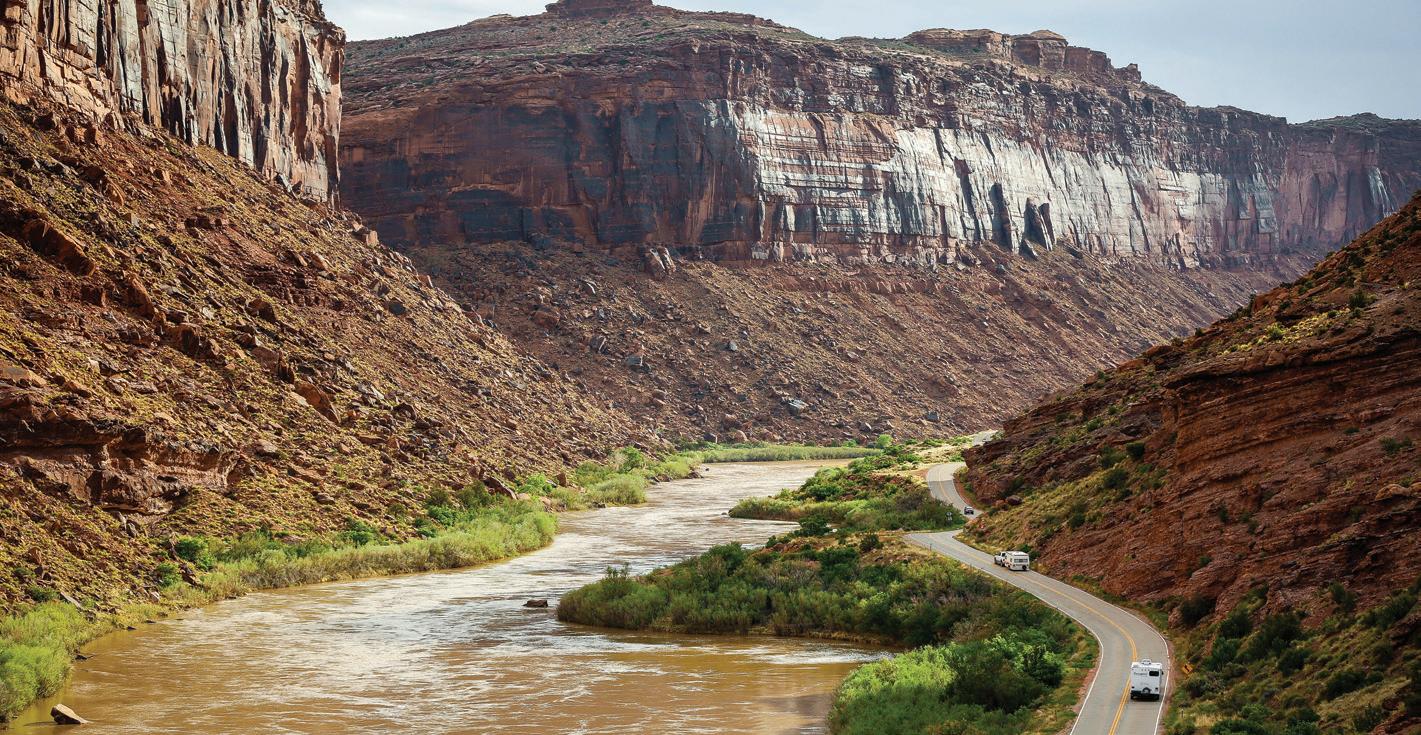
Thishoursspectacular route along the Colorado River gorge begins at the Colorado River Bridge on the north end of Moab. For the first 13 miles (20.9 km) it parallels the Colorado River within a narrow section of the gorge, providing breathtaking views of the surrounding red sandstone cliffs. Popular attractions along this portion of the route include viewpoints of the river, BLM campgrounds, and Grandstaff Canyon, which contains a delightful hiking trail to Morning Glory Natural Bridge. At 13 miles (20.9 km) the gorge widens as the highway proceeds past Castle and Professor Valleys, which have been the shooting locations for many western films including Wagon Master and Rio Grande, along with numerous television commercials. The Moab to Monument Valley Film Commission has a museum at the lodge located at Mile Marker 14 that houses memorabilia from early films to present. Admission is free. After 24.7 miles (39.8 km) the highway passes a viewpoint for one of the grandest views in the west, the red rock spires of the Fisher Towers set against the often snow covered peaks of the La Sal AfterMountains.leaving the valley, the road winds farther up the river gorge until arriving at the site of historic Dewey Bridge at 29.8 miles (48 km). Unfortunately Dewey Bridge was destroyed
The Moab area has three State Scenic Byways which are designed to recognize, preserve and enhance selected roads throughout the United States based on their archaeological, cultural, historic, natural, recreational and scenic qualities. Every trip to Moab should include a drive along at least one byway, although driving all three is a great way to spend a relaxing day.
Upper Colorado River Scenic Byway (SR 128)
Time to Allow: 2
discovermoab.com | Moab Outdoor Adventure Guide - 27
Length: 44.0 mi / 70.8 km
Length: 17.0 mi / 27.4 km Time to Allow: 1 ThishourScenic
Byway provides great views of the Colorado River, ancient rock art and dinosaur tracks. A late afternoon start is rewarding as the sunset on the reddish-orange sandstone cliffs along the route is especially beautiful on the return drive to Moab. This byway begins 4.1 miles (6.6 km) north of Moab, where the Potash Road (SR 279) turns off of US Highway 191. After 2.7 miles (4.3 km) Potash Road enters the deep gorge of the Colorado River. At the 4 mile (6.4 km) point, look for rock climbers on the cliffs along the road. This area is called Wall Street.
28 - Moab Outdoor Adventure Guide | discovermoab.com
Potash-Lower Colorado River Scenic Byway (SR 279)
Trailhead parking for the Corona and Bowtie Arch Trail is available at 9.9 miles (15.9 km).
in April 2008 by a brush fire. The road then follows the northern bank of the river for a few more miles before exiting the Colorado River gorge. At this point the highway proceeds across open desert toward the ghost town of Cisco at 44 miles (70.8 km). Cisco was founded as a water refilling station for steam locomotives along the main line of the Denver and Rio Grande Western Railroad. After another 5 miles (8 km) the route intersects Interstate 70.
At 5.1 miles (8.2 km) several petroglyph panels are visible on cliffs on the right side of the highway. Marked pull-offs on the left side of the road provide parking to view these panels. An interpretive sign provides additional information. At 5.9 miles (9.5 km) the Poison Spider Trail parking will be on the right. A kiosk on the end of the parking lot, near the vault toilet, has a map for a short trail to dinosaur tracks and rock art. (Never touch rock art or dinosaur tracks. They can be easily damaged.)
Corona Arch, with an opening of 140 by 105 feet, is also known as Little Rainbow because of its resemblance to Rainbow Bridge at Lake Powell. This trail is designated as a National Recreation Trail. Look for Jug Handle Arch, adjacent to the highway, at 13.5 miles (21.7 km). Shortly beyond Jug Handle Arch, the canyon widens and the sheer cliffs below Dead Horse Point State Park become visible in the distance. The paved highway ends at the Intrepid

Dead Horse Point State Park, back track to SR 313, turn left, and head toward the Island in the Sky District of Canyonlands National Park, ultimately ending at Grandview Point. This section of the park sits atop a massive 1500 foot mesa – quite literally an Island in the Sky. Twenty miles (32.2 km) of paved roads lead to many of the most spectacular views in canyon country. Dead Horse Point is one of Utah’s most spectacular state parks. Towering 2,000 feet above the Colorado River, the park provides a breathtaking panorama of Canyonlands’ sculpted pinnacles anddiscovermoab.combuttes.
Potash Mine where potash, a mineral often used as a fertilizer, is extracted by flushing large volumes of water through an extensive system of underground tunnels and then evaporating the water in ponds. From the end of this byway, drivers with high clearance vehicles can continue on a dirt road to the Island in the Sky District of Canyonlands National Park. A free day-use permit is required for travel on the White Rim Road in Canyonlands National Park. Permits are available online at canypermits.nps.gov.
Length: 35.0 mi / 56.3 km Time to Allow: 2 hours minimum, but several additional hours are recommended to enjoy the state and national parks. Dead Horse Mesa Scenic Byway, on SR 313, takes you through miles of incredible red rock canyon country. To reach the byway, head north from Moab on US Highway 191. After about 9 miles (14.5 km), look for the “Dead Horse Point State Park” sign and turn left (west) onto SR 313. This is the start of the byway. After a series of hairpin curves as you begin to ascend the plateau, the road mellows out allowing you to appreciate the scenery. The BLM has two scenic pullouts along this section of road; Monitor & Merrimac Viewpoint and La Sal Mountain Viewpoint. At about 14.6 miles (23.5km) from the beginning of SR 313 a fork to the left leads to Dead Horse Point State Park. Note that a fee is required to proceed to the viewpoints. The view from Dead Horse Point is one of the most photographed scenic vistas in the world. Towering 2,000 feet above the Colorado River, the overlook provides a breathtaking panorama of Canyonlands’ sculpted pinnacles and Afterbuttes.leaving
Dead Horse Mesa Scenic Byway (SR 313)
| Moab Outdoor Adventure Guide - 29

30 - Moab Outdoor Adventure Guide | discovermoab.com

| Moab Outdoor Adventure Guide - 31
Length: 480 Miles Time to Allow: 3 – 4 days - Loop through western Colorado and eastern Utah on I-70, US Highway 40, US Highway 191, SR 128, Colorado 139 and Colorado 64 Season: Spring through fall. Some side trips are on unpaved roads that can be impassable after rain or snow; check locally before proceeding.
If you happen to be passing by Jensen, Utah, Dinosaur National Monument has a visitor center with thousands of fossils of many species of dinosaurs to witness, along with a Dinosaur Quarry to explore.discovermoab.com
Dinosaur PrehistoricDiamondHighway
Traces of prehistoric “thunder lizards” highlight the route through an expanse of Utah and Colorado. Dinosaur fossils and footprints date from 150 million years ago, when conditions were right for preserving the bones of huge plant-eaters and those of the fierce carnivores that preyed on them. As you drive this loop, you will pass rugged red-rock canyons, spectacular geological formations, and cottonwood-lined rivers flowing through rolling, arid, high-plains terrain.
The Dinosaur Diamond is a total of 480 miles, and can take 3 to 4 days to experience the entire loop. Depending on where your journey begins, and where you are headed, the main points of the historical byway are briefly described to assist you in an exciting dinosaur exploring adventure.

Be Safe: Many unpaved roads in this area are suitable for ordinary cars, but they often become impassable when wet, so be sure to check the weather forecast before setting out. When riding through this arid landscape, drink water early and often to avoid the dangers of dehydration.
Fruita is the western gateway to Colorado National Monument, with its gorges and monoliths. Get an overview of the park along 23-mile Rim Rock Drive, a paved road with overlooks and interpretive areas offering far-reaching panoramas. The loop returns to its start along Colorado 139, which climbs to excellent views at 8,240-foot Douglas Pass. The highway passes through Canyon Pintado National Historic District, a “painted canyon” with more than 200 Native American pictograph and petroglyph sites. Roadside signs identify several of these sites as you drive north to Rangely.
32 - Moab Outdoor Adventure Guide | discovermoab.com
Vernal, Utah, is reached by heading down US Highway 40. The Dinosaur Garden is outside of the Utah Field House of Natural History State Park Museum located in Vernal. Here there are 18 life-sized models that were discovered in 1991. If you stay on this route it will take you to Price, Utah. A recommended stop for dinosaur buffs is the Utah State University Eastern Prehistoric Museum, which has a spectacular display of fossil dinosaurs and a cast of a mammoth skeleton. For more dinosaur interests, take a short side trip off the main loop. From Price drive south on Utah 10 for 12 miles to Utah 155 and turn east to Elmo and Cleveland. Follow signs to Cleveland-Lloyd Dinosaur Quarry, which has the most concentrated collection of Jurassicera dinosaur bones known anywhere. Back in Price, the loop heads southeast for 60 miles through rolling terrain and washes to meet I-70. Go east 25 miles and continue south on US Highway 191 toward Moab. The Moab area contains an abundance of dinosaur tracksites. Refer to the Dinosaur Trails & Tracksites section of this guide for full details. There are also many spectacular examples of rock art in the Moab area. The Rock Art Auto Tours section of this guide contains full Yourdetails.next stop off US Highway 191 (at the intersection of SR 313) is the Moab Giants Dinosaur Museum. State-of-the-art dinosaur exhibits feature dinosaurs that roamed the area and their tracks, which are found in abundance around Moab. The site also contains a 3D Theater, 5D Prehistoric Aquarium and an outdoor Dinosaur Trail that contains over 100 life-sized dinosaurs.
Heading toward Moab, you will pass the spectacular Arches National Park, which boasts a premier showcase of rock formations and more than 2,000 natural arches. Many formations can be seen from park roads, especially in the Windows area. After Arches, continue into Moab, which offers a plethora of activity options such as biking, hiking, rafting and exploring all of the striking beauty that Moab has to offer. The Upper Colorado River Scenic Byway (SR 128) starts at the Colorado River Bridge on the north end of Moab. Over the state line, stop in Fruita, Colorado to visit the Dinosaur Journey Museum, full of robotic dinosaur models, fossils, interactive displays, and dino-themed exhibits. After your museum visit, drive to Dinosaur Hill (one mile south on Colorado 340) and view past excavations of several important dinosaur finds.

Biocrust
that immature biocrust looks similar to light-colored bare soil but develops into the mature black pinnacles shown on the right. Have fun. Be Safe. Leave No Before You Go
discovermoab.com | Moab Outdoor Adventure Guide - 33
• Check the weather forecast before you travel. If the weather forecast predicts thunderstorms in the area, have a backup plan ready.
LightningTrace.-Know
• Plan your activities around the weather. In summer months, thunderstorms usually develop in the early afternoon, although they can occur at any time. Leave for your trip in the early morning to avoid running into storms.
Biocrust, also known as cryptobiotic soil, is the foundation of desert plant life. This black, knobby crust is made up of many different living organisms and plays a vital role in maintaining the desert ecosystem. Biocrust holds together sand grains, which helps prevent erosion and dust. It also holds moisture and fixes nitrogen in the soil, which helps plants to survive. However, this sensitive soil is extremely fragile and can take decades to grow. Even a footstep can damage the crust for decades, having lasting impacts on the desert environment. Please stay on the trails. Help protect this fragile, but crucial, life by remaining on designated roads, routes, and trails at all times. Where hiking trails are not established, hike in sandy washes (dry stream beds) or on bare Noterock.
• Know how long it will take for you to get to safe shelter. Plan ahead and be aware of how far you are away from safety if you are outside and encounter lightning or thunder.
• Listen to the NOAA Weather Radio. NOAA provides the latest weather conditions and forecasts even for remote areas that may not have cellular coverage. You can also sign up for text and email weather reports and updates, such as NWS Wireless Emergency Alerts. Just remember, many areas do not have cell service.


34 - Moab Outdoor Adventure Guide | discovermoab.com Rock Art Auto Tours

Guide - 35
| Moab
The Moab area has some spectacular Indian rock art to explore and enjoy. With rock art scattered throughout Moab’s unforgettable scenery, the journey to rock art sites is sure to make for memorable adventures. All sites described in this guide are accessible with a passenger car and a short walk! There are two types of rock art: petroglyphs (motifs that are ground, pecked, incised or scratched into the rock surface) and pictographs (which are painted or drawn in one or more colors using mineral pigments and plat dyes on the rock surface). Although many images were created using both techniques, most now appear only as a petroglyph because the paint material has faded or washed away over many years. Fortunately, there are both types of rock art to be found in the sites described in this guide. Each site is unique. The patterns and motifs may be similar, but never quite the same. Styles will vary from place to place and from people to people. Remember to never touch rock art or surfaces around it. The oils in your skin may cause permanent damage.
Rock Art Auto Tours
The People Rock art was produced by a number of prehistoric and historic peoples over thousands of years. Their histories in the area are very complex. A big game hunting people, known as Paleo-Indians, are considered to be the first human users in the area. Their game included now extinct Pleistocene fauna such as mammoths and mastodons. A later culture called Archaic, probably used central base camps during their seasonal round of activities based on harvesting wild plants and animals. They did not build permanent habitation structures, but lived in caves and in small brush shelters built in the open. The Ancestral Puebloan whose culture centered south of Moab in the Four Corners area, concentrated much of their subsistence efforts on the cultivation of corn, beans and squash. These sedentary people also harvested a wide variety of wild resources, such as discovermoab.com Outdoor Adventure

• Don’t collect or disturb artifacts or features at a rock art site. It is acceptable to pick up surface artifacts, examine and enjoy them, or make sketches or take photos of them, as long as they’re returned to the place where found, and no damage is done to the artifact.
• Minimize the number of vehicles going to a site. Stay on existing roads and trails. Do not “pioneer” vehicle trails or parking areas. By disturbing rocks, vegetation, or biological soil crusts you may cause unknowing damage to fragile archaeological sites.” Don’t camp or build fires within 1/4 mile of a rock art site, even if the landowner or public land manager permits camping.
• Please remember that many living people consider these sites sacred.
36 - Moab Outdoor Adventure Guide | discovermoab.com
• Don’t remove soil to expose subsurface rock art or archeology.
• Don’t touch, in any way, the rock art or surfaces around it. The oils in your skin may cause damage to rock art. Don’t apply any substance to the rock art surface, including water or any other fluids. Don’t trace images with sticks, stones, chalk, or other substances.
• Don’t allow children, pets, or inattentive people to behave carelessly around rock art sites. Kicking up dust or dislodging rocks can cause damage to the site.
Site Visiting Etiquette
• Don’t attempt to remove graffiti, chalking, lichen, bird droppings, or anything else from rock art.
pinion nuts and grasses, and hunted bighorn sheep and deer. The Fremont, who were contemporary with the Ancestral Puebloan people, also grew corn, and were apparently more dependent on hunting and gathering wild resources than were the Ancestral Puebloan. Their territory was mainly north of the Colorado River, but overlapped with the Ancestral Puebloan at Moab. Both cultures had a complex social structure, and were highly adaptive to the extremes of the environment. The Ancestral Puebloan and Fremont are classified by scientists as “Formative” cultures.
Dating the Rock Art
• Speak out when needed to prevent damage to rock art. Report new rock art destruction, charcoal near the site, or site vandalism to the Archaeological Resources Protection Act hot-line @ 1-800-227-7286.
Although it is difficult to establish an exact age of rock art, some dating clues are easily identified. For example, whenever a horse and rider is depicted, we know the date to be after A.D. 1540 when the Spaniards reintroduced the horse to the New World. The presence of bows and arrows is presumed to indicate a date after A.D. 500, the generally accepted time period for their appearance in this region. For purposes of this guide, time periods are broken into generalized categories relating to the people believed to have made them.
The most recent inhabitants, the Utes, have been in southeast Utah since the 1200’s. They were a very mobile hunting and gathering people who moved in from the Great Basin. They used the bow and arrow, made baskets and brownware pottery, and lived in brush wickiups and tipis. The Notah (Ute people) lived freely throughout western Colorado and eastern Utah until about 1880, when they were forced onto reservations.
• Graffiti, which has become a serious problem across public lands, is not only socially unacceptable, but is illegal.
Navigation for this route is easy and all sites can be accessed by car in good weather conditions. There is nothing difficult about the route. The USGS 7.5-minute map titled “Sego Canyon” shows the area.
The company store and a boarding house still partially stand in the center of town. There are ruins to many houses scattered throughout the canyon along with remnants of the coal mine. This wonderful rock art and historic ghost town can be viewed as a short side trip from I-70 near Green River Utah. Plan to spend about 2 hours to visit both the rock art and ghost town combined with a little exploring on your own. Remember to respect any private property in the area.
From downtown Moab travel 31 miles north to I-70. Drive 5.4 miles east on I-70 and take exit 187. Drive north on the main road through the community of Thompson Springs. The three rock art panels are located 3 1/2 miles north of Thompson Springs. The road is paved to the pictographs and petroglyphs. The site is protected by a wooden fence and has a small parking lot complete with information plaques, picnic tables and a vault toilet.
Birthing Scene Rock Art BLM Map ID: 2 (Page 34)
discovermoab.com | Moab Outdoor Adventure Guide - 37
Sego Canyon is a great adventure the entire family will enjoy. The canyon contains rock art from three different Native American cultures and a very well preserved ghost town.
Sego Canyon Rock Art BLM Map ID: 1 (Page 34)
Courthouse Wash Rock Art NPS Map ID: 3 (Page 34) Drive north from Moab on US Highway 191 and cross the Colorado River Bridge. Proceed 1/2 mile to a parking area on the right side of the road. Walk back across the small bridge that crosses Courthouse Wash on the graveled foot path. At the east end of the bridge, face the 11:00 position and look up at the cliffs. Walk uphill to the base of those cliffs and look for an extremely faint rock art panel. The rock art consists of a large pictograph and petroglyph along with associated petroglyphs on the rock slabs at its base. The panel is approximately 19 feet high by 52 feet long. The site, located in Arches National Park, was badly vandalized in 1980. Conservation work has helped stabilize the site. No conservation treatment can ever recover what is lost, or fix a vandalized archaeological site.
From downtown Moab travel south on US Highway 191 to Kane Creek Boulevard. Turn right and travel on Kane Creek Boulevard past the private property, where the road turns from pavement to a graded gravel road. After traveling a total of 5.3 miles from the intersection of Kane Creek Boulevard and 500 West, you will see two small pullouts suitable for single vehicles. Approximately 75 feet west and down the slope from the road, is a large boulder with rock art on all four sides. Figures and designs range from the Formative to the historic Ute period. The well-known “birthing scene” is found on the left hand corner of the east side of the boulder (facing the road). Notice the feet-first presentation of the baby. Look for various animal forms, such as a centipede and a horse, bear paws and a snake, as well as triangular anthropomorphic (human) figures and a sandal trackway.
Wolfe Ranch Rock Art NPS Map ID: 6 (Page 34)
Golf Course Rock Art BLM Map ID: 4 (Page 34) Take US Highway 191 south to Spanish Trail Road (approximately 4 miles from the comer of Main and Center in downtown Moab). Turn left and proceed on Spanish Trail Road to approximately 1 mile just past the fire station located on the left-hand side of the road; turn right onto Westwater Drive. Proceed 1/2 mile to a small pullout on the left-hand side of the road (please do not block or go up the private driveway). The panel runs from ground level up to approximately 30 feet on the high rock wall. Designs cover an area about 90 feet wide. The panel is from the Formative Period and you will be able to see human figures, such as the “Moab Man”, elk, canines, and big and small bighorn sheep. Look to the far right of the panel and find what is popularly referred to as the reindeer and sled.
Located in Arches National Park, the Wolfe Ranch panel is a fine example of historic Ute rock art. Follow the signs to Wolfe Ranch and Delicate Arch, 14 miles from the park 38 - Moab Outdoor Adventure Guide | discovermoab.com
You will see large painted ghost-like illustrations typical of the Barrier Canyon Style of rock art, which is the same style as the famous Great Gallery panel in Canyonlands National Park. Archaic figures on the red-orange surface. The numerous figures include human forms, bighorn sheep, shields, scorpion-like illustrations, possible dogs, a long beaked bird and abstract elements. You can see evidence of painted multi-colored figures superimposed on other pictographs. On the desert varnish surface you will see human and animal like figures as well as abstract forms. This site is on the National Register of Historic Places because of its representation of a Barrier Canyon Style rock art panel.
Kane Creek Boulevard Rock Art Sites BLM Map ID: 5 (Page 34) At the comer of Main and Kane Creek Boulevard (McDonald’s is on the southwest corner) turn west and proceed 8/10 mile to the intersection of Kane Creek Boulevard and 500 West. Stay left and continue along Kane Creek Boulevard approximately 2.3 miles to the mouth of Moonflower Canyon. Along the rock cliff just beyond the canyon, you will see a rock art panel dating from the Archaic to Formative Periods. The site is behind a protective fence. There is a Barrier Canyon Style figure (a large triangular shape with headdress), desert, bighorn sheep and a number of abstract elements. The panel is from ground level to a height of about twelve feet and extending approximately 100 feet. You will see a blue residue left from an illegal latex mold on one of the bighorn sheep motifs. This entire panel is one of the most vandalized rock art sites in the Moab area. Continue another 1.2 miles to another rock art panel. A huge rock surface covered with desert varnish faces the river from the cliff side of the road. Here, you can see bighorn sheep, snakes, human forms, and a trail, possibly indicating a route from the river up Kane Springs Canyon. Again, you will notice some vandalism. (If you miss this site, it may be seen more easily on the return trip.)
discovermoab.com | Moab Outdoor Adventure Guide - 39
Potash Road Rock Art Sites BLM Map ID: 7 (Page 34)
From US Highway 191 take SR 279 (Potash Road) south for 5 miles where you will find an “Indian Writing” interpretive road sign, and pull out adjacent to the river. Caution: Watch for highway traffic. Looking 25 to 30 feet up the rock wall on the cliff side of the road you will see petroglyphs from the Formative Period. Look for the line of “paper doll cutouts” and horned anthropomorphs holding shields and abstract images, as well as a wide variety of other animal and abstract images. The panel extends along the road 125 feet. The round holes carved into the sandstone underneath the left side of the petroglyph panel once held the roof poles of a structure which was excavated by archaeologists prior to road construction. The structure and the rock art panel were easily accessible before the talus slope was cleared away to make room for the road. Continue south 200 yards to the “Indian Writing” sign. You will find the large bear with a hunter at the bear’s nose and another over its back. At an interpretive pullout approximately 3/4 miles further along SR 279, you can see Indian rock art and dinosaur tracks. On the north side of the road, two spotting tubes indicate the location of three-toed allosaurus tracks in the Navajo/Kayenta sandstone interface. Binoculars are needed to view the petroglyphs located to the left of the tracks at the base of the cliff, or you can hike the trail from the Poison Spider Trailhead.
Approximately 7.5 miles farther along SR 279 is Jug Handle Arch (near the mouth of Long Canyon). Proceed to Jug Handle parking area via a dirt road that travels east from the highway. The rock art is located above the parking area to the north. If you have trouble locating the rock art once you are near a given site, don’t be discouraged. Remember: Check your mileages. You will develop a sense of which types of rocks and surfaces are appropriate areas to look for petroglyphs and pictographs. Petroglyphs are commonly found on the black or brown surface (called desert varnish) of rock cliffs. The straight, smooth, red sandstone found in the Navajo and Wingate formations is a good area to look for pictographs. As you spot one image, look carefully around the adjoining surface areas. Often there are numerous images at any given site. Some of the images may be very faint, having faded or eroded through the years. You will sometimes see one layer of images on top of another. Remember, these are irreplaceable sites. Take many pictures, leave only footprints, and enjoy traveling back in time!
entrance. At the Wolfe Ranch parking lot, walk east 600 feet along the established trail past the cabin and across the wash. The Ute hunting panel site is on a trail that branches left off the Delicate Arch trail just past the bridged wash.

2010 – 127 Hours Blue John Canyon, Horseshoe Canyon, Sand Flats Recreation Area, Green River, Moab the Days Tomorrow National Moab 128 Hittle SR 279 SR 279, National Park
SR 128, Arches
40 - Moab Outdoor Adventure Guide | discovermoab.com
2002 – Austin Powers 3 SR
2014 – Transformers: Age of Extinction Hole in the Rock 2013 – The Lone Ranger Fossil Point and surrounding area, SR 279, Goldbar Campground, Professor Valley 2013 – After Earth Fossil Point and surrounding area 2010 – John Carter Lake Powell, Hanksville, Fossil Point, SR 279, Dead Horse Point, Fisher Towers
For information on filming in the area, get in touch with the Moab to Monument Valley Film Commission 435-259-4341. Here are some of the films made in the Moab area:
Wall Street, SR 313 2000 – Nurse Betty SR 128 and
1999 – Vertical Limit Monument Valley 1999 – Mission Impossible II Dead Horse Point State Park 1997 – Lost Treasure of Dos Santos Onion Creek, Flat Pass, Bates Ranch 1996 – Con-Air Dead Horse Point State Park, Canyonlands National Park, Monument Valley and Lake Powell 1996 – Breakdown Professor Valley, SR 313, Gas station near Highway 191/SR 313 intersection 1995 – Riders of the Purple Sage Dugout Ranch, Flat Pass, Mill Creek Canyon, Kane Springs Road and Pucker Pass 1993 – Geronimo: An American Legend Professor Valley, Potash Trail, Potash Plant, Needles Overlook area, Sand Dunes off Ruby Ranch Road, Bates Ranch, Lawson Ranch, Onion Creek
Bottom,
Seeing that the production employed almost all of Moab’s 1,500 residents, local rancher George White founded the film commission to promote movie making in the area and establish a local crew base and production services.
near
Moab Area Movie Locations
Park,
Regional Hospital 2007 – All
Arches
Director Ridley Scott reported that he had “seen more wonderful and varied scenery in a single day in Moab than any other day [he had] scouted.” Such variance has made Moab a hot spot for movies of all genres. From the ranches of the old west, to the interplanetary fields of Mars, to mile after mile of classic road-trip roads, the scenery is as endless as the possibilities. Visitors to Moab may find the area familiar as they tip-toe up to Thelma and Louise Point, set off on horseback to follow John Wayne’s hoof prints, or take in the view from Westworld’s Hub Mesa. Filmmakers will find thousands of square miles of sand deserts, snowy mountains, desolate canyons, verdant farmland, empty roads, and rushing rivers – not to mention the iconic red rocks.
The Moab to Monument Valley Film Commission holds the title of the longest running film commission in the world. Harkening back to the days of John Wayne and the classic western, the Moab area has been a popular destination for feature length films, commercials, and television shows for almost 70 years. In 1949, John Ford first ventured out from the iconic Monument Valley to film along the majestic Colorado River Corridor.
Before

Guide
White’s Ranch, Castle Valley, Professor Valley, Arches National Park, Dead Horse Point State Park
North US Highway 191 - Arches National Park, Seven Mile Canyon, Bull Canyon, Ten Mile Road
•
1993 – City Slickers II: The Search for Curly’s Gold Dugout Ranch, Fisher Towers, Onion Creek 1990 – Thelma and Louise Shafer Overlook, Arches National Park, La Sal, Cisco, Thompson Springs, Fossil Point 1988 – Indiana Jones and the Last Crusade Arches National Park, Sevenmile Canyon 1987 – Nightmare at Noon Moab City, Ken’s Lake, Arches National Park, Colorado River 1985 – MacGyver Dead Horse Point State Park, Shafer Overlook 1984 – Choke Canyon Moab, Onion Creek, Professor Valley, Sand Flats, Dead Horse Point State Park, Byrd’s Ranch, Squaw Park 1975 – Against a Crooked Sky
Professor Valley, Colorado River, Castle Valley, Arches National Park, Dead Horse Point State Park 1964 – Rio Conchos
1963 – The Greatest Story Ever Told Island in the Sky, Green River Overlook 1963 – Cheyenne Autumn White’s Ranch, Castle Valley, Professor Valley, Colorado River, Fisher Canyon, Arches National Park, Monument Valley, Mexican Hat 1961 – Comancheros Professor Valley, Dead Horse Point State Park, Kings Bottom, La Sal Mountains, Fisher Valley, Onion Creek 1959 – Ten Who Dared Big Bend of the Colorado River, White’s Ranch, Arches National Park, Dead Horse Point State Park 1950 – Rio Grande White’s Ranch, Ida Gulch, Professor Valley, Colorado River, Onion Creek Narrows 1949 – Wagon Master Professor Valley, Colorado River, Spanish Valley
•
SR 211 - Dugout Ranch, Marie Ogden Settlement 1-70 - Cisco, Thompson Springs, Ruby Ranch (exit 175), Green River City, Floy Wash (exit 175), San Rafael Swell (Goblin Valley State Park, Little Wild Horse Canyon)
For more information on movies filmed in the Moab area vist: filmmoab.com.
•
•
Take a drive down any of the following highways to catch a glimpse of the places where many of these movies were filmed. Although the sets for these movies no longer exist, the scenery is timeless.
•
Other Locations - Kane Creek, Sand Flats, Byrd’s Ranch, Moab City, Pack Creek Ranch, Ken’s Lake, Mill Creek Canyon, Flat Pass Outdoor Adventure - 41
•
South US Highway 191 - Monument Valley, La Sal, San Juan County, Lake Powell
discovermoab.com | Moab
SR 279 - Shafer Trail, Shafer Trail Overlook, Potash, Fossil Point, Pucker Pass, Long Canyon, Wall Street
Moab Area Set Locations
SR 128 - Onion Creek, Fisher Towers, Ida Gulch, White’s Ranch (Red Cliffs Adventure Lodge), Castle Valley, Professor Valley, Big Bend, Hittle Bottom, Castle Rock (Castle Valley turnoff), Harley Bates Ranch, Lawson Ranch (Professor Valley turnoff), Hauer Ranch, Hook `n’ Ladder Area
SR 313 - Dead Horse Point State Park, Green River Overlook (Canyonlands National Park), Island in the Sky (Canyonlands National Park)
•
•
42 - Moab Outdoor Adventure Guide | discovermoab.com

While our area is known for its family-oriented raft trip on the Fisher Towers section of the Colorado River (The Moab Daily), people also enjoy canoes, kayaks and paddle boards to explore the calm water segments of the Colorado. Enjoy a guided trip with one of Moab’s many professional river outfitters or try it on your own with rental equipment from a local company. Please help preserve these beautiful river spots so that everyone will be able to enjoy the primitive character for years to come.
discovermoab.com | Moab Outdoor Adventure Guide - 43
ActivitiesColoradoRiver


Highlights
Description Camping is not allowed at the Cisco boat ramp. There are vault toilets here.
Fish Ford to Dewey Bridge
Determine a river stretch suitable for your equipment, skill and time commitment.
Length 5 miles
Description Camping is allowed at Fish Ford. There is a short distance between the end of the road and the river’s edge, so you will have to carry your boat. There is a small dirt boat ramp.
44
Flat water flowing under high cliff walls. Bull Canyon is river right in 2.5 miles downstream. Good hike. - Moab Outdoor Adventure Guide
Flat water winding around islands. Some homesteads/private land on the riverside.
Dewey Bridge to Hittle Bottom Highlights
Highlights
Getting there
| discovermoab.com
Colorado River Sections
Flat water among low hills. SR 128 begins to parallel the river 7 miles downstream. At 9.5 miles downstream, the Dolores River enters on river left.
Length 11 miles Getting there From I-70, take exit 214. This road leads to the ghost town of Cisco. Turn left at a decrepit building with a faded mural. This road intersects with another. Turn left. In 2.5 miles, go right at a Y to get to Fish Ford river access.
From I-70, take exit 214. Turn south at the stop sign. This road leads to the ghost town of Cisco. Turn left at a decrepit building with a faded mural. This road intersects with another. Turn left. In 2.5 miles, stay left at a Y to go to the Cisco boat ramp.
Cisco to Fish Ford


Camping is allowed at both Dewey Bridge and Hittle Bottom campgrounds based on first come first served. Often occupied by car camping folks. There is a vault toilet here.
Highlights
Rocky Rapid/Ida Gulch to Big Sandy Beach
Highlights Class II-III rapids are in this section. Not suitable for flat-water craft. All boaters are encouraged to stay left at White’s Rapid just downriver from the lodge, to avoid rough water and recirculating hydraulics.
Rocky Rapid is 16 miles from the Junction of SR 128 with US Highway 191.
Hittle Bottom is 23 miles from the junction of SR 128 with US Highway 191.
Flat water flows to this access on river left. There are two sloped boat ramps into the river at Onion Creek. Rapids begin immediately downstream of this point.
Length 2 miles Getting there
Four class II-III rapids are located in this section. Not suitable for flat-water craft. Boaters taking out at Rocky Rapid must stay center or left in the rapid and cut left immediately afterward to access the boat ramp.
Onion Creek is 19.5 miles from the junction of SR 128 with US Highway 191. Turn left onto a dirt road that leads to the campground and river access.
Description Camping is allowed only in designated sites on river right. There is a fee. Based on first come first served. Often occupied by car camping folks. There are vault toilets here. No camping is allowed at Rocky Rapid.
Length 4 miles Getting there
Description Camping is not allowed at the Rocky Rapid river access. There are vault toilets here.
Description Camping is allowed in designated sites on river right. There is a fee. Based on first come first served. Often occupied by car camping folks. There are vault toilets here.
Length 5 miles Getting there
Description
Highlights
Length 6 miles Getting there
Onion Creek to Rocky Rapid/Ida Gulch
Dewey Bridge is 28.7 miles from the junction of SR 128 with US Highway 191.
Hittle Bottom to Onion Creek
discovermoab.com | Moab Outdoor Adventure Guide - 45
Big Bend is 7.5 miles from the junction of SR 128 with US Highway 191.
Highlights Flat-water from the wide Moab Valley into a narrower corridor after entering the West Portal. SR 279 parallels the Colorado River to Gold Bar and Potash. Navigate around islands.
Take Out is 9.9 miles from the Junction of SR 128 with US Highway 191.
Length 4 miles Getting there
Big Sandy is 11.8 miles from the junction of SR 128 with US Highway 191.
Big Sandy to Take Out
Moab Bridge to Gold Bar
Big Bend to Moab Bridge
Description Camping is not allowed at the Moab Bridge area. Across the pedestrian bridge in Lion’s Park there are toilets and water.
Length 3 miles Getting there
46 - Moab Outdoor Adventure Guide | discovermoab.com
Take Out to Big Bend Campground
Highlights Rapids are in this section.
Description Camping is not allowed at the Rocky Rapids, Big Sandy or Take Out river access. There are vault toilets here.
Length 10 miles Getting there
Highlights Watch for an additional rapid below Big Bend before regaining flat-water. Afternoons can have significant upstream wind.
There is a steep dirt boat ramp on the north side of the Colorado River. From SR 128 travel north, make a right turn after crossing the river bridge. Be advised, in exiting this access, make only a right-hand turn. Go over Courthouse Wash bridge to turn around in a trailhead parking lot on the right.
Description Camping is allowed at Big Bend Campground. There is a fee. Based on first come first served. Often occupied by car camping folks. Vault toilets here.
Length 8 miles Getting there
Highlights At Big Bend there is a rapid. This access is NOT a boat ramp. There is a distance between the end of the road and the river’s edge.
River Use Regulations
• Dispose of human waste in approved facilities.
River Use Ethics
Personal Flotation Devices are made for humans and dogs. It is required by law that humans wear these at all times on board the watercraft and during transitions at the water’s edge.
Getting there Goldbar is 10.2 miles from the junction of SR 279 with US Highway 191. Potash Boat Ramp is located at the end of the pavement of SR 279.
Length 7 miles
• Respect wildlife encountered along the river.
Description Camping is not allowed at the Potash Boat ramp/picnic area. There are vault toilets here.
• All garbage, ash, charcoal, and trash must be carried out on all portions of the rivers. Even small scraps of food left behind will attract ants, flies and mice.
Personal Flotation Devices (PFDs)
• Gather only driftwood for campfires. Be aware of fire restrictions. All fires must be contained in a fire pan. Ash and charcoal packed out.
• Urinate directly into the river.
Description Camping is allowed at Gold Bar Campground. There is a fee. Based on first come first served. Often occupied by car camping folks. Vault toilets here. There are marked trails nearby for hiking.
Highlights Flat-water. This is the last vehicular river access; do not miss the take out!
• Carry a first aid kit, a repair kit and an air pump. Rafts, dories and canoes must carry an extra oar, paddle or motor capable of maneuvering the vessel, a bail bucket or bilge pump (does not apply to self-bailing boat, kayak or paddle boards). Kayaks, inflatable kayaks, and stand up paddle boards (SUPs) must carry one spare paddle for every 3 low capacity vessels. Each boat 16’ or longer must carry a type IV throwable device AND a commercially made throw bag with a minimum of 40’ of line. Each boat must have a whistle or discovermoab.comhorn. -
| Moab Outdoor Adventure Guide
47
Gold Bar to Potash Boat Ramp
• Carry and use a leak-proof portable toilet for solid human waste. Recommended for day use; mandatory of overnight trips.

Tamarisk Control & Restoration
• Tamarisk is a concern to communities and recreationists because it forms dense stands that block access to river and stream banks – areas which support a range of native plant materials and other important cultural resources.
Tamarisk, also known as saltcedar, was introduced into the United States in the 1820s as an ornamental and was later used for windbreaks and stream bank stabilization. In some locations tamarisk has since taken the place of native trees and shrubs, like cottonwood, willow, and even some upland species, and it now infests rivers, streams, wetlands, reservoirs, and springs across the West. Tamarisk has been declared a noxious weed in all western states, except Idaho.
48 - Moab Outdoor Adventure Guide | discovermoab.com
Biological control (biocontrol) is the introduction of an insect or other “natural enemy” of the plant of concern. The tamarisk beetle (Diorhabda spp.) was tested by the US Department of Agriculture for decades to ensure that it would be effective and would not feed on native plants or crops in the western US. It was first released along the Colorado River in 2004. The tamarisk beetle and its larvae feed on the leaves of tamarisk,
• Tamarisk infestations along waterways can change hydrological patterns and there can be a high rate of water loss associated with tamarisk evapotranspiration.
Why are the trees along the Colorado River turning brown and what are those tiny beetles near the river?
• The replacement of native vegetation with tamarisk affects plant and animal diversity, especially in riparian areas. Tamarisk can be poor habitat for many types of wildlife, poor forage for livestock, and can increase soil salinity and wildfire severity.


For more information visit discovermoab.com/tamarisk-tree/, or scan the QR code on the right with your mobile device.
For more information visit revegetation.org, or scan the QR code on the right with your mobile device.
For more information visit riversedgewest.org, or scan the QR code on the right with your mobile device.
Working Together Beetle activity in the area prompted the Southeast Utah Riparian Partnership to form in March of 2006. It is comprised of local, state, and federal agencies; businesses; non-profit organizations; and individuals who work in riparian areas. The Partnership shares information and provides networking opportunities to foster collaborative and interdisciplinary action to find creative, lasting methods to improve vegetation and habitat along the Colorado River and its tributaries in Utah.
Rim to Rim Restoration, along with RiversEdge West, helps coordinate and lead the Partnership. Rim to Rim Restoration is a Moab based non-profit dedicated to the reestablishment of native vegetation to support maintaining sustainable watersheds in the Upper Colorado Plateau. Rim to Rim helps build community and facilitate regeneration of native plants through collaboration on projects focused on improving conditions in high use areas in SE Utah and learning from the plants grown for these projects.
RiversEdge West (formerly Tamarisk Coalition) is a regional non-profit that focuses on riparian forest and floodplain health in the American West to address impacts from invasive riparian plants and associated challenges and stressors that may result in diminished biodiversity and ecosystem services. In addition to providing information on the best practices and technical aspects of restoration, RiversEdge West specializes in fostering grassroots leadership by coalescing diverse stakeholders across boundaries to coordinate the riparian restoration, such as evidenced with its work with the Partnership.
discovermoab.com | Moab Outdoor Adventure Guide - 49
leaving them dry and brown with many straw-like leaves still attached to the plant. This “defoliation” or “browning” may happen several times during a growing season and does not necessarily indicate death. While many trees may die after 5-7 years of beetle defoliation, others may continue to live. However seed viability and general vigor are reduced, allowing native plants take advantage of available resources such as water, sunlight, and nutrients.


The Moab area’s beauty, history, and, hundreds of miles of old mining roads and 4-wheel drive trails make it a place that will never be forgotten. Visitors can bring their own vehicle, rent a jeep, or take a tour with one of Moab’s experienced & permitted guides. Moab has a full range of backcountry trails, from easy 2-wheel drive backcountry scenic drives to the ultimate in challenging 4-wheel drive trails, providing an opportunity for all to experience the beauty and solitude of an off road adventure. Always obtain the most up-to-date information prior to departing for a trip, and be prepared. Remember, turning back is usually an option as well. Please choose your trail wisely, with honest appraisal of your equipment and experience in this terrain. Once you arrive in Moab, detailed 4-wheel drive maps and trail guides are available at the Moab Information Center (MIC), on the corner of Main & Center Streets. The MIC staff is always happy to assist you with your plans and provide information about current trail conditions. The following trails were selected because they are close to Moab and short enough for a partial-day trip. Among the trails is a variety of scenery and a range of challenge to the off-highway abilities of vehicle and driver. Difficulty 4-wheel driving difficulty is hard to describe objectively. Opinions vary, and an individual’s judgment may change considerably as they gain experience. The easiest of these trails is suitable for stock high-clearance four-wheel drive vehicles. The most difficult trails are barely passable to first-rate off-road equipment. The other trails are well within the capabilities of stock four-wheel-drive trucks and utility vehicles.
50 - Moab Outdoor Adventure Guide | discovermoab.com 4-Wheel Drive Trails
4-Wheel Drive Trails

For descriptions of most of Moab’s 4-wheel drive trails visit the Red Rock 4-Wheelers website at rr4w.com or scan the following QR code: Adventure
Guide - 51
Difficulty: Moderate
The primitive nature of 4-wheel drive trails makes them hard to mark and keep marked. On some, routes are obscure, while on others, the roads are clear enough but the many unnamed junctions are confusing. Storms can alter roads and remove tracks, while vandals can spoil the markings. Nevertheless, a sign has been placed to identify each trail a short way into the trail. After that, routes and junctions are marked in ways appropriate for the terrain, wooden posts may have a “trail” sign, slickrock may have painted symbols, and most areas will have cairns -small rock piles-to show the route. Topographic maps provide additional help and add to the enjoyment of off-road travel.
4-Wheel Drive Road: 43 miles Minimum Time: 3-1/2 hours
Round Trip from Moab: 54 miles
Trail Marking
Further along, the canyon broadens, and you can see Hurrah Pass on the right. The gravel road changes to dirt at the ford of Kane Creek [6.4]. Do not attempt to ford in high water; the water can be window-deep following storms or heavy spring melts. Beyond the ford, stay with the best-looking road as other trails leave to the left in the next half mile, and the road will bend toward the north and begin to ascend the cliffs below Anticline Overlook (note the safety fence on the cliff edge above). The summit of this climb is Hurrah Pass [10.0]. As the trail winds down the other side of the anticline, it shows more four-wheeldrive character. The trail leaves the cliffs on a gentler slope and drops into a wash bottom. Continue straight (out of the wash) where a spur trail leaves to the right and follows the rough wash bottom [12.5]. Shortly after that, an optional route enters a small canyon to the left; the preferred route up the rocky slope to the right swings close to the river on a bench above it. Farther on, two trail junctions [14.4 and 14.6] leave to the left in view of a large side canyon and a mound of red rocks not far to the left of the trail. These trails go to the
discovermoab.com | Moab Outdoor
Chicken Corners BLM Map ID: 1 (Page 50)
The route travels the Colorado River Canyon just below Moab, follows a spectacular part of Kane Springs Canyon, climbs the Kane Creek anticline to Hurrah Pass, and descends to benches above the Colorado River. The trail dead-ends at Chicken Corners about 400 feet above the river across from Dead Horse Point. Trail Directions From Main Street at Center Street in Moab, travel south on Main 6/10 mile, turn right on Kane Creek Boulevard, follow it through two sweeping curves past its junction with 500 West and continue into the river canyon. When the pavement ends near Kane Creek [0.0], continue on the good gravel road as it enters Kane Springs Canyon and follows the canyon meanders at various levels above the creek. Continue with the gravel road as it crosses the mouth of Hunter Canyon at a hiking trailhead [3.2].
rock mound and its interesting catacomb caves. The main trail continues along the river benches, which are capped with fossil-bearing limestone, until it crosses a major wash [17.1]. (On the return trip, you will probably spot an unusual arch near the trail east of the wash crossing.) The trail you may see starting up this wash is the Lockhart Basin trail. You follow the main trail straight across the wash and follow along the benches as they wind higher above the water. The point where the trail is pinched between rocks on the left and the abyss on the right [20.3] is “Chicken Corners” where Moab area guides were reputed to allow “chicken” passengers to walk, rather than ride, past the narrow, sloping section of trail. The trail continues along the broad bench until it narrows to an old horse trail [21.5]. You can’t go much farther, even on foot, because this is the start of a peninsula of land bounded by the gooseneck of the Colorado, the trademark of the spectacular view from Dead Horse Point. Return to Moab by the same route.
Difficulty: Easy The trail covers a region between US Highway 191 and SR 313, reaches some grand vistas, and accesses numerous other trails. The highlight is the spectacular twin arch, called Gemini Bridges, on the rim of an arm of Bull Canyon. Trail Directions From the center of Moab, travel north on US Highway 191 for 9.8 miles (you are still south of the SR 313 junction). Turn left to cross a cattle guard near an old ore car by the railroad tracks [0.0], cross the tracks, and turn left to follow the southerly dirt road paralleling the tracks. The main trail soon veers right toward the cliffs, and steadily climbs the cliff slope to Little Canyon, the gap in the cliff rim. Stay with the best maintained trail through upper Little Canyon (old mine trails leave left and right, and a strong spur trail leaves left into a side canyon). Turn right from the wash bottom area [4.8] to climb the steep dugway. The trail passes a gate and winds to higher levels, giving vistas in all directions. Stay with the main trail as spurs leave to the left, and fork right where the good left-hand trail leads to the lower levels of Bull Canyon [6.2] as it begins a sweeping bend to the right. This lessmaintained trail is the older route; the graded road is not shown on many trail maps. As the trail winds still higher, ignore two spur trails to the left and watch for the “Y”, junction that indicates that you are near Gemini Bridges. Keep left at the “Y” [7.4] and follow the markings; past visitors have left numerous unnecessary trails. As you approach the canyon, you will see the deep hole [7.8] that opens into the canyon wall leaving the twin spans. Return part way toward the “Y” junction, but take- the short-cut [8.0] to the left to join the main trail that was the right-hand fork of the “Y”. Turn left on this main trail [8.1], and turn right where a spur trail heads down to Crips Hole [9.0]. The trail joins the graded road that you were on earlier near a drill pad [9.7], and you travel the graded road westerly to paved SR 313 [13.8]. There, a right turn returns you to US Highway 191, while a left heads for Dead Horse Point State Park and the Island in the Sky District of Canyonlands National Park.
52 - Moab Outdoor Adventure Guide | discovermoab.com
Gemini Bridges BLM Map ID: 2 (Page 50) Round Trip from Moab: 48 miles 4-Wheel Drive Road: 14 miles Minimum Time: 2-1/2 hours
Difficult
•
•
• Mile 0.0-0.3: Trail starts out as a gravel road before climbing up rock fin with white painted markers, trail signs and rock lining, then eventually up a slickrock dome to the base of a steep sand hill. Go straight here or follow the easier alternate route to your left, marked with white dots. Stay on marked trail.
• Mile 1.8 Intersection at Fox Campground. Go right to base of steep rocky hill, or take easier alternate route to your left. Please be considerate when driving through campgrounds. Follow signs to Hawk Campground.
•
•
• Mile 2.4: Hawk Campground. Toilet on your left, trail goes right.
•
•
•
The first section between the start and Fox Campgrounds is not recommended for ATVs. ATV users should pick up the trail on the Sand Flats Road at the Diving Board Rock formation which is 3.7 miles from the Entrance Station. A fee is required to enter the Sand Flats Recreation Area.
Fins and Things SAND FLATS BLM Map ID: 3 (Page 50) Round Trip from Moab: 20 miles 4-Wheel Drive Road: 9.4 miles Minimum Time: 3 hours
• Mile 3.5: North entrance on left immediately after Diving Board Rock. Two-way travel for .6 miles
•
• Mile 4.1 Intersection with Porcupine Jeep Trail; go left. One-way travel only.
Fins and Things is a one-way trail. It starts 1.9 miles from the Sand Flats Entrance Station (5 miles from downtown Moab), beside campsite ‘E-6’ in Echo Campground. For trailer parking, please park prior to this on the south side of Sand Flats Road 1.4 miles from Entrance Station. OHVs are permitted on the Sand Flats Road. The trail is marked with metal signs and white symbols painted on the slickrock surface. Due to hazardous terrain, it is recommended only for experienced drivers.
• Mile 5.4: Stay straight; spur to overlook on right.
Difficulty:
• Mile 1.4: Series of steep drops through a slickrock ravine. No alternate routes here. Stay on the trail.
•
• Mile 0.8: Trail drops off fin to right, climbs up again, then drops to the right. Go left here.
• Mile 5.6: Bear right; left goes to Radio Tower and Sand Flats Road. Mile 6.1: Stay left at Wilderness Study Area boundary which is closed to all motorized travel. Mile 6.7: Large canyon to right. Nice lunch stop with views of Arches National Park. Mile 7.0: Cross ravine, climb slickrock to your right. Watch for symbols. Mile 7.3-7.4: Climb fin, then hard right at Mile 7.4. Stay on marked route which is almost all slickrock. Mile 7.7: Left is exit to main road (1/2 mile); right continues out on a fin. Mile 8.1: Intersection; stay right. In 1/2 mile, you will cross here again. Mile 8.6: Hard right, then left. Follow symbols on an up-and-down ride to mile 9.0. Mile 9.0: Continue on trail 4/10 mile to main road. Mile 9.4: Sand Flats Road. Right will take you to the Entrance Station and back to Moab.
discovermoab.com | Moab Outdoor Adventure Guide - 53
• Mile 2.5: Sand Flats Road. Turn right.
• Mile 0.0: Trailhead, 1.9 miles from Entrance Station on right.
Traveling with Pets
54
Safety Information in the Heat
• Back country hiking - In the backcountry a leash is recommended, not required, but dogs do need to be under verbal restraint and not chase or harass wildlife. Be sure to keep your pets away from dangerous cliff areas; dogs can fall or get stuck on ledges when allowed to run off leash. - Moab Outdoor Adventure
• Watch for Heatstroke - Even if you don’t keep your pets in a hot car, hot summer weather can still be bad for your pet’s health. Find out about the symptoms of heatstroke in dogs, and how you can prevent it.
• Identification - Make sure the identification tags on your pet’s collar are up to date and fastened securely to the collar. An updated rabies vaccine is required for all dogs and cats in the state of Utah.
Pet Etiquette and Local Laws
• Trails - Find out where the pet friendly trails and other pet friendly places, such as the Moab Bark Park (100 East 300 South), can be found. Read the hiking section of this guide to see where you can go without leaving your furry friends behind.
• Never Leave Your Pet in the Car - On sunny and warm days, the air in the car doesn’t circulate and the temperature can rise within minutes to a point where it can become life threatening. Even if the windows are cracked, cars heat up quickly and your pet can be in danger. For example, a 70 degree day will quickly heat up to 104 degrees inside the car.
• Rest Stop Areas Mean Everyone Gets a Break - Take your dog out for a walk; offer some water and a snack. Be sure you’ve got plenty of water around for both you and your pets, especially on hot days.
• Sunblock Is for Pets Too - Did you know that animals can get sunburned, too? This is especially true for animals with light-colored skin. If that describes your pet, talk to your vet about getting some pet-safe sunscreen and then be sure to use it (particularly on areas like the nose and ears). Protect their feet as well; the pavement and backcountry trail rocks and sand can be scorching on your pet’s paws.
• Clean Up After Your Pet - Bring plastic bags, litter, or bedding. Wherever you stay, don’t forget to clean up after your pet. It’s both common sense, and courteous to the places you’re visiting.
Guide | discovermoab.com
• Research and Obey Local Laws - In Moab City all dogs must be kept on a leash, in Grand County all dogs must be kept under restraint, no owner shall fail to exercise proper care and control of his or her animals to prevent them from becoming a public nuisance.

• Find the Local Emergency Vet - Know before you go where the emergency vet is in the area you are staying in case your pet becomes injured. It saves a lot of stress and time in the event that your pet needs immediate medical attention. Veterinarian offices located in Grand County are Mill Creek Animal Hospital 435-259-2733 and Moab Veterinary Clinic 435-259-8710. For more information call 435-259-4862, visit the Humane Society of Moab Valley’s website, moabpets.org, or scan the QR code on the right with your mobile device: discovermoab.com Outdoor Adventure Guide - 55
Pet Health • Vet Records - Bring a copy of your pet’s vaccines. Hotels and vacation rentals often ask for proof of your pet’s vaccines.
• Pack with a Purpose - Keep pet travel essentials in your vehicle. This list includes a water bowl, bottled water, extra leash and collar with identification tags, poop bags, an old towel, pre-moistened wipes, a basic first-aid kit, necessary medications, a copy of health records, bedding, treats, one or two favorite toys and at least a threeday supply of food.
• Keep Bugs Away - Spring, summer and fall is high travel season, and it’s also a high bug season. Things like sticktight fleas, ticks, lice and even heartworm can be an issue for your pets during the warm months so take precautions against them before you leave home.
Travel and Lodging
• Find Pet-Friendly Accommodations and Activities - Before you leave home, you can find out about a variety of pet-friendly events going on in and around the places you’ll be visiting on your trip, and you can also make sure you’re booking stays at hotels, campgrounds, and vacation rentals that allow pets – check out the Discovermoab.com lodging listings for pet-friendly accommodations.
• Hotel rooms - Don’t leave your pet alone in the hotel room, even if the hotel is dog friendly; a barking dog can be considered a nuisance. If local animal control is called your pet may be impounded at the shelter.
| Moab
• Kennels and Carriers - Some places require that your pet be in a carrier or crate when left alone. A kennel is also a safe way for your pet to travel.
• Practice Water Safety - Just because your dog loves the water doesn’t mean he or she always knows its dangers! Keep an eye on your pet around water, especially when it’s an unfamiliar place. Animals won’t know about fast-moving currents, how tired they can get if they swim out too far (or for too long), and potentially-poisonous water sources, among other things. If your pet will be in and out of water often on your trip, bring along a life-jacket for him or her, too.
• Medication - Make sure you have enough of it for the duration of your time away from home. Pick up refills for your pet before you head out.
• Desert Plants - You might be familiar with the plants that grow where you live, but desert plants such as cactus, cheat grass, foxtail or other plants can be a problem for pets. The danger for pets lies in sharp spines or the “invasiveness” of dry seed pods that can work their way into fur, paws, skin and mucous membranes, and removal may require a visit to the vet.
56 - Moab Outdoor Adventure Guide | discovermoab.com OHV Recreation Areas

discovermoab.com | Moab
• Not exclusively reserved for OHV use.
Adventure Guide - 57
• Does not possess a valid driver’s license; and (Note: Learners permit requires licensed parent/guardian seated next to driver (adult supervision))
Age Requirements
Anyone under 18 can operate an OHV on public land (there is no longer an 8-year-old minimum age requirement) if they are:
For a video overview of what you need to know before hitting the trail, visit discovermoab.com/atvriding or scan this QR code with your mobile device: Outdoor
UTV/ATV Recreation
Helmet Requirements Properly fastened helmet, having at least a “DOT Approved” safety rating for motorized use is required for all OHV operators and passengers under the age of 18 years. A properly fitting, safety-rated helmet is the most important piece of safety gear available to an OHV rider.
• Have in their possession an OHV education certificate or a valid Driver’s License and;
• Under direct adult supervision Adult supervision is required if:
• Open to motor vehicles; and
UTV/ATV Video
Moab has numerous trails suitable for off-highway vehicle (OHV) use, such as utility terrain vehicles (UTVs) and all terrain vehicle (ATVs). Much of the public land surrounding the National Parks is available for travel on designated routes. Please note that UTV/ATV riding is not allowed within either Arches or Canyonlands National Parks. This means that UTVs/ATVs are prohibited on the White Rim Road, Salt Valley Road, and Willow Springs Road.
• Able to reach and operate each control necessary to safely operate the off-highway vehicle and;
• Operating an OHV on a public highway that is:
• Under 18;

A muffler and spark arrestor (snowmobiles are exempt from the spark arrestor requirement). Quiet mufflers (under 96 dB by the J1287 test) help to protect trail access.
All OHVs are required to have certain equipment in working order while being operated in Utah, including: Brakes sufficient to stop and hold the machine
• If your UTV/ATV does not meet these requirements it must be transported to and from the trailhead. 58 - Moab Outdoor Adventure Guide | discovermoab.com
Is your UTV/ATV Street-Legal in Utah?
Equipment Requirements
•
• Properly registered as street-legal in your home state.
•
UTVs and ATVs are allowed to be operated on paved roads, streets, and highways (not interstate highways) in the Moab area when the vehicles are:
• Comply with all of the Utah street-legal equipment requirements shown above.
A headlight and taillight while being operated between sunset and sunrise
•
• Properly insured for highway use.
•
A brightly colored whip flag attached to the OHV and at least eight feet off the ground while being operated on designated sand dune areas
Your vehicle must have (1) a license plate from your home state and (2) meet all of the Utah requirements shown above. If your home state does not issue license plates to ATV/UTVs, your vehicle cannot be street legal in Utah. If your vehicle is not street legal it must be trailered or towed to the trailheads. Street legal UTVs and ATVs are not allowed on interstate highways. Carefully examine the requirements below:

Permits
Non-Residents
Any OHV being operated or transported on public lands, roads, or trails, of the State of Utah must display a current OHV registration sticker. All OHV registrations are handled by the Utah Division of Motor Vehicles (DMV).
If a street-legal OHV is registered and has a license plate from your home state, and it meets all of Utah’s street-legal requirements, then you do not need to purchase a Utah Non-Resident OHV Permit. If your vehicle is not street legal you need to purchase a Non-Resident OHV Permit to operate your vehicle on Utah’s trails. Non-Resident OHV are valid for one year from the date of purchase and can be purchased on-line or in Online Non-Resident OHV Permit purchases can be made stateparks.utah.gov/activities/off-highway-vehiclesat: available in person at authorized vendor locations throughout the state of Utah. The following authorized vendors are located in Moab: Moab Information Center, Center and Main, 435-259-8825 Bro, 1805 S US Highway 191, 435-259-6232 Maverik, 435 N Main, 435-259-8718 Maverik, 985 S US Highway 191, 435-259-0775 Spanish Trail Shell, 2420 Spanish Trail Rd, 435-259-3939 applying in person, you will need the
Utah Residents
OHV Permits & Registration
person.
following: • Proof of residency: driver’s license or other state-issued identification. • Proof of ownership: title or recent registration or bill of sale. UTV/ATV regulations change frequently. Although the information in this guide is correct at the time of printing, for the latest information always check with the Utah State Parks and Recreation Department at 801-538-7433 or visit their stateparks.utah.gov/activities/off-highway-vehicles/website:( or scan the QR code on the right) Drive Slowly Through Residential Neighborhoods To help reduce noise, Moab’s in-town speed limit for ATV/UTVs is 15 mph. Grand County also has a speed limit on County B Roads which is 10 mph less than the posted speed limit. Please observe all speed limits and avoid driving through neighborhoods at night to provide solitude for residents and preserve your right to ride. We encourage street legal ATV/UTV riders to limit in-town driving by trailering their vehicles to the trailheads whenever discovermoab.compossible.|Moab Outdoor Adventure Guide - 59
•
When
•
• Mad
•
Permits are
•
60
BLM
White Wash Sand Dunes
To reach the White Wash Sand Dunes from Moab drive 7 miles west of US Highway 191 on I-70. Take Exit 175 (Floy) to the south. Continue southwest on the Floy Wash Road for 12 miles. Be sure to bear right 4.5 miles from I-70, and then continue straight at 7.8 miles from I-70. Go east (left) at 12.3 miles southwest of I-70. The trailhead latitude/longitude is 38.80348623, -110.0444765. There are no facilities of any type at White Wash Sand Dunes. Visitors must pack out all trash. There is no drinking water in the area. If you camp, please use a previously used camping spot. You must have and use a portable toilet. Be advised that the closest dump stations are in the town of Green River. Specific campsites are not marked. Help to keep all of our trails open. Protect this fragile, but crucial, soil by remaining on designated roads, routes, and trails at all times. - Moab
Outdoor Adventure Guide | discovermoab.com
If you prefer riding in a designated open area then try the White Wash Sand Dunes.
The White Wash Sand Dunes are located 48 miles northwest of Moab, and 25 miles southeast of Green River. The sand dunes themselves are delineated and fenced for open off-highway vehicle (OHV) play; cross country travel is allowed only in the open area. Outside of this area, there are thousands of miles of designated routes, many of which are singletrack limited to motorcycles or ATV trails limited to vehicles under 50” wide. Staying on the designated routes helps keep these routes open for your enjoyment. Damage to adjoining private property has occurred and is a threat to your continued enjoyment of this area. Staying on designated routes assures that you will not trespass on private property. Please avoid the oil production facilities and the adjoining ranch, and never chase or harass livestock. When going through gates, leave them open or closed as you found them. You must stay on designated roads and trails when riding outside the dune area. These routes are marked with signs. Bighorn sheep inhabit this area; riders should avoid stressing these animals by giving them the space they need. The cottonwood trees growing in the White Wash area are quite unique. Please avoid damaging these trees and give them a wide berth to reduce potential for soil compaction.


Pritchett Canyon (Extremely Difficult) 18.5 miles
•
Kane Springs Road (Easy) 5.6 miles Kane Creek Trail (Difficult) 38 miles Chicken Corners (Moderate) 21 miles Hurrah Pass (Moderate) 14.4 miles
•
•
discovermoab.com | Moab Outdoor Adventure Guide - 61
Kane Creek is a 38 mile trip following Kane Creek along the canyon bottom with around 50 creek crossings. The trail tends to have brush, meaning that vehicle paint damage is likely. Eroded narrow shelves in sections that climb out of the bottom create difficulty. The route ends at US Highway 191 near Hole in the Rock, 22 miles south of Moab. A shuttle will be necessary for OHV; otherwise plan an out-and-back itinerary.
•
Pritchett Canyon requires a fee to cross private property. It starts in a narrower canyon and spills into the Behind the Rocks area. This is an extremely difficult trail. No bypasses are possible. Alternatively, you can enjoy this region via an access 28 miles south of Moab in the Behind the Rocks area.
Cliffhanger Trail (Difficult) 20 miles
Moab Area OHV Trail Access
•
Chicken Corners is beyond Hurrah Pass on a loose sand road paralleling the Colorado River downstream and finishes at a bench 400 feet above the river. The actual Chicken Corners is now a hiking trail. Many years ago, when it was a pack trail, only the least “chicken” passed this spot. Lockhart Basin extends from the Chicken Corners area and is in very poor condition due to erosion. More difficult trails are Cliffhanger and Kane Creek. Cliffhanger is the only vehicle route on the Amasa Back. If Kane Creek is running, quicksand and high water makes Cliffhanger dangerous as you must cross the creek to access the route. A gate crosses the trail so please leave it as you found it, open or closed. Amasa Back is about 12 miles roundtrip, but may take all day. This challenging trail has epic stair step ledges. On top, from a cliff edge, peer into the Jackson Hole area.
Description Beyond this trailhead are Kane Springs Road, Hurrah Pass, Chicken Corners, Lockhart Basin Cliffhanger, and the Kane Creek Trail. Pritchett Canyon is near the end of the pavement of Kane Creek Boulevard. Kane Springs Road is a relaxing trip with awesome views. As the climb to Hurrah Pass ensues, the trail is moderate up to the top of the pass.
Trailhead
•
This parking area is at the end of Kane Creek Boulevard, 4.3 miles from the junction of US Highway 191. Continue after the end of the pavement, and the parking area will be bordered by low posts and yellow cable.
Lockhart Basin (Difficult) 44.2 miles
•
The following information indicates parking areas to assist non-street legal machines with trail access. It is an overview which should be supplemented with maps or guide books which can be purchased at the Moab Information Center and many shops in Kanetown. Springs Access BLM Map ID: 1 (Page 56)
Mill Canyon Access BLM Map ID: 2 (Page 56)
Dubinky Well Road intersects with SR 313, but off of it is the Rainbow Terrace with a mix of curves, sandy wash bottoms and moderate rock challenges. Hidden Canyon is picturesque although past misuse of this area have led to a great deal of fencing.
•
•
•
•
Trailhead On North US Highway 191, 13.9 miles from Center Street in Moab. Turn west. This is also Cotter Mine Road.
Description Seven Mile Rim has Uranium Arch along the route and it passes Determination Towers before dipping into Tusher Wash and circling back via Cotter Mine Road. Also out there 62 - Moab Outdoor Adventure Guide | discovermoab.com
It is easy to get to Tusher Tunnel, an interesting slot passage that is fun to experience. Bartlett Wash is another easy route in the vicinity with a few wet crossings. Caution: Flash flooding is possible.
•
•
A large parking area with an earthen loading ramp will be on the right in 6/10 mile.
Description From the parking lot head out toward Blue Hills Road to connect with a myriad of trails.
Trailhead Go 15 miles north on US Highway 191 and turn left onto a dirt road marked “Mill Canyon.”
Seven Mile Rim Access BLM Map ID: 3 (Page 56)
•
•
•
Spring Canyon Point is off the Dubinky Well Road. Spring Canyon Point Road is wide most of the way and is easy out to the point. A branch off of Spring Canyon is Secret Spire, a noticeable pinnacle seen from many spots in the area. Returning from the end of Spring Canyon Point, at 1.8 miles, catch a spur that is a frolicsome 1.7 miles to Cliff Hanger Arch and views into Hey Joe Mine. The Cotter Mine Road parallels US Highway 191 and connects Mill Canyon Road to the trailhead for Seven Mile Rim trail area.
Further south along Dubinky Well Road, Spring Canyon Bottom Road reaches the steep canyon, where switchbacks drop down to the Green River. From there, a narrow and brushy 4-wheel drive trail leads to Hey Joe Canyon alongside the river, so please minimize your engine sound. South of Dubinky Well Road, Mineral Point Road can be looped with Hell Roaring Rim Trail for views into yet another tributary of the Green River. Tusher Tunnel (Easy) 13.8 miles Bartlett Wash (Moderate) 13.3 miles Rainbow Terrace (Moderate) 18.8 miles Secret Spire (Moderate) 9.6 miles Blue Hills Road (Easy) 13.8 miles Dubinky Well Road (Easy) 12.4 miles Spring Canyon Point (Easy) 13.6 miles Spring Canyon Bottom Road (Easy) 12.1 miles Hell Roaring Rim Trail (Easy) 37 miles Cotter Mine Road (Easy) 3 miles
•
•
•
Bull Canyon is a wash bottom that eventually gets quite rocky, leading up to parking and a short walk to arrive beneath the Gemini Bridges. Metal Masher requires winching for Widow Maker Wall. The trail is very difficult overall. Four Arch Canyon and The Boulevard are off-shoots to further explore this trail area. Goldbar and Golden Spike are trails heading southward into the Poison Spider Mesa. Gemini Bridges (Moderate) 12.9 miles Metal Masher (Very Difficult) 22 miles
• The Boulevard (Easy) 3 miles
Gemini Bridges
Access via US Highway 191 BLM Map ID: 4 (Page 56)
• Little Canyon Rim (Difficult) 6.5 miles
• Golden Spike (Very Difficult) 21
Sandflats Recreation Area Access SAND FLATS BLM Map ID: 5 (Page 56)
Go east on East Center Street and turn right onto 400 East. Travel 4/10 mile and turn left onto South Mill Creek Drive. In 1/2 mile there is a 3-way stop. Continue straight as the road becomes Sand Flats Road. There is an entrance booth in 2 miles. Some parking is available at Hell’s Revenge 4x4 Trailhead near the entrance booth. Another gravel staging area is located 1.4 miles from the entrance booth for Fins and Things 4x4 Trail.
Trailhead
Description This is a fee area. Pay for the day or for a week of access to Fins and Things, Hell’s Revenge, and Porcupine Rim 4x4 Trails. There are first come, first served campgrounds here (for an additional fee). There is riding right out of the Sand Flats campgrounds. The Sand Flats Road ends at the pavement of the La Sal Mountain Loop Road.
•
are 3-D Trail, Hidden Canyon and Hidden Canyon Overlook. Hidden Canyon has soft sand and is easy, but can be slippery and impassible when wet. Hidden Canyon Overlook is a short climb to outstanding views. Further on are cairns, white dashes on slickrock sandstone and signs for 3-D. 3-D has what looks to be a wall to the uninitiated, but looks worse than it is. Seven Mile Rim Trail (Difficult) 20.4 miles 3-D Trail (Moderate) 28 miles Hidden Canyon (Easy) 2 miles
•
Hidden Canyon Overlook (Moderate) 10.3 miles
Trailhead
discovermoab.com | Moab Outdoor Adventure Guide - 63
•
Gemini Bridges is an easy out-and-back trip from SR 313. From the parking lot on US Highway 191 the climb up into the trail area requires skill. There is terrific scenery of the La Sal Mountains and the Book Cliffs. This area requires excellent skills.
Description
• Bull Canyon (Easy) 8.7 miles
• Goldbar Rim (Difficult) 15.9 miles
•
On North US Highway 191, 9.9 miles from Center Street in Moab, turn west. Fee area.
• Four Arch Canyon Road (Moderate) 3.25 miles
•
On US Highway 191, 17.9 miles south of Center Street in Moab, turn west into the Behind the Rocks area.
Behind the Rocks Trail (Easy and Moderate) 29.7 miles Kane Creek Canyon Rim Road (Easy) 3 miles
Description A portion of the Behind the Rocks Road is easy. That easy stretch offers camping on Utah School and Institutional Trust Lands Administration (SITLA). Gathering firewood is prohibited. Camping is limited to designated sites. Users must bring and use a portable toilet. The stretch beyond the camping area is moderate with some easy sections on the Kane Creek Canyon Rim Road. Picture Frame Arch is accessible via a network of trails. Tip Toe, Hunter Canyon Rim Trail and Pritchett are difficult routes. Strike Ravine is across US Highway 191 from the Behind the Rocks. The trail traverses a rugged canyon area dappled with remnants of mines.
• Fins and Things (Moderate) 9.4 miles • Hells Revenge (Moderate) 6.5 miles • Porcupine Rim (Moderate) 14.7 miles • Sand Flats Road (Easy) 19.3 miles
On SR 313, 16 miles from the junction of US Highway 191 with SR 313.
Dewey Bridge Access BLM Map ID: 8 (Page 56)
Description North of the Colorado River, Dome Plateau covers a huge part of the desert. Be certain 64 - Moab Outdoor Adventure | discovermoab.com
Access BLM Map ID: 6 (Page 56)
•
Strike Ravine (Difficult) 11 miles
•
•
Trailhead
Trailhead
Guide
Hunter Canyon Rim Trail (Difficult) 4.8 miles
On SR 128, 28.7 miles from the junction of US Highway 191 and SR 128.
•
Behind the Rocks
Trailhead
•
Tip Toe (Difficult) 33 miles Pritchett (Very Difficult) 16 miles
Mineral Bottom Access BLM Map ID: 7 (Page 56)
Description Mineral Bottom Road goes straight out to the rim of the mesa. At the cattle guard stop to peer over the edge to access traffic since a series of switchbacks going down into Mineral Bottom is too narrow for two vehicles to pass. This road ought to be traveled upstream by OHVs as downstream leads to Canyonlands National Park, and OHVs are prohibited from the trail in the National Park. Take a break at the river and return to SR 313, or from the parking lot there is a tangent that courses to become Hell Roaring Rim Trail.
to have sufficient fuel for riding the trails there. Please note that Kokopelli’s Trail is shared with mountain bikes. To the south of the Colorado River, are Top of the World, Rose Garden Hill and the Dolores River Overlook trails, plus more of the Kokopelli’s Trail. Onion Creek can be accessed from this vantage too, which is a kind of back way into Onion Creek.
Trailhead On Kane Creek Boulevard, 1.9 miles west of 500 West in Moab.
•
• Dome Plateau (Moderate) 6.2
Poison Spider Access BLM Map ID: 9 (Page 56)
Top of the World (Difficult) 4.2 miles
Help to keep all of our trails open. Protect this fragile, but crucial, soil by remaining on designated roads, routes, and trails at all times.
Description
• Moab Rim Trail (Difficult) 6.3 miles
• Rose Garden Hill Trail (Difficult) 37 miles
• Kokopelli Trail (Moderate) 150 miles (Fruita, CO to Moab, UT)
• Dolores River Overlook (Easy) 17.9 miles
There are drop-offs, steep ascents and descents and numerous slickrock domes. Get a glimpse of the railroad tracks to the Potash Mine and gaze down at Corona Arch. Golden Spike has many obstacles to navigate.
Moab Rim Trail Access BLM Map ID: 10 (Page 56)
Description
Trailhead On SR 279, six miles from the junction of US Highway 191 and SR 279.
• Poison Spider Mesa Trail (Difficult) 21 miles
• Onion Creek (Moderate) 11.4 miles
• Golden Spike (Difficult) 23 miles
For descriptions of most of Moab’s 4-wheel drive trails visit the Red Rock 4-Wheelers website at rr4w.com or scan the following QR code: | Moab Outdoor Adventure Guide - 65
discovermoab.com
A succession of ledges and tight turns over tilted bedrock leads to the top, which has stunning views into Moab and Spanish Valley. The La Sal Mountains to the south and Bookcliffs to the North are visible in the distance. This is an out-and-back trail.
66 - Moab Outdoor Adventure Guide | discovermoab.com Motorcycle Trail Riding

Along with the proper gear, groups should bring maps and possibly guide books. Although most of the graded roads and featured trails have directional signs, conditions are subject to change. In the event of an emergency, maps can show your options to evacuate. The government-agency maps and most commercial maps indicate which types of travel are allowed for each route. (Be sure to ride on the world class motorized singletrack and avoid the mountain bike only trails.)
The Moab area offers tremendous diversity for motorcycle trail riding. From graded roads to singletrack trails, you can choose a new adventure for each day of your visit… and your next visit. With that sense of freedom comes a responsibility to respect yourself, others, and the land itself. So please remember to ride within your ability, stay precisely on the trail, and yield to people or animals. This will help to keep Moab accessible and enjoyable for generations.
On public lands, motorized and even bicycle travel is limited to designated routes. The Bureau of Land Management (BLM) provides up-to-date designated route maps. Likewise, the U.S. Forest Service (USFS) provides up-to-date motor vehicle use maps. Commercial maps include Moab Classic and Moab East/West by Latitude 40, which are available for sale at the Moab Information Center (Main & Center Streets in Moab) and shops in town. Guide books include “ATV Trails Guide” and “Backroads & 4-Wheel Drive Trails”. These books are available at the Moab Information Center, and can also be purchased in
discovermoab.com | Moab Outdoor Adventure Guide - 67
Motorcycle Trail Riding
In Moab, a handful of guiding and rental services can assist you to make the most of your visit. If choosing to go out with your own group, be prepared. Most trails are very remote, and cellular coverage is spotty at best. Even in spring and fall, temperatures can reach above 100 °F and below 32 °F. Low humidity calls for bringing extra water, such as one gallon per person. Storms cause drainages that are normally dry to become impassable, and they cause clay-based dirt that is normally dusty to become extremely slick & muddy.

Riders seeking a longer-distance, or less-rugged, experience can utilize the network of graded, dirt roads. They are generally maintained, but of course wash outs and other hazards can occur. If your motorcycle is street-legal, you can follow graded roads all the way to towns like Green River, Monticello, and even Fruita, CO. Kokopelli’s Trail is dual-sport friendly, except for the rocky hill above Onion Creek and the non-motorized section below Cisco. The Rimrocker Trail (rimrockertrail.org) allows you to enjoy 160 miles of off-pavement travel while experiencing the many different stunning landscapes that connect Montrose, Colorado to Moab, Utah. Even ‘in the middle of nowhere,’ you could encounter oncoming traffic, so be careful around blind corners.
4-wheel drive trails are the perfect way for most motorcyclists to explore the canyon country. These primitive roads offer spectacular scenery, with difficulty that ranges from moderate to extreme. Their width provides room to pass, and provides an alternate line for riders to choose. The routes used during the Jeep Safari event are marked, and extend from Moab in every direction. Originally blazed for uranium exploration mining, these iconic trails made Moab a top 4-wheel drive destination.
At the most primitive end of the spectrum, motorized singletrack is available for riders seeking the confines of a narrow trail. These routes typically require a high degree of skill. Also they lend themselves to lighter-weight motorcycles with a smoother power band and low gearing. Unless you particularly value singletrack, then stick to the 4-wheel drive trails for a greater sense of freedom. For example, motorized singletracks are shared with non-motorized users, and motorcyclists should yield to them. However pulling off the singletrack could easily damage plants and biological soil crust (the black and craggy dirt that’s actually alive). So you’ll need to pass by either leaning over the trail’s edge, or finding a barren surface such as slickrock to pull over. In the desert, singletrack is a scarce commodity, so please help to keep the “single” in singletrack.
68 - Moab Outdoor Adventure Guide | discovermoab.com advance online from Canyonlands Natural History Association.
Note that, to ride the roads in national parks, your motorcycle must be street-legal and a permit is required. While Canyonlands and Arches National Parks are known for routes like White Rim, Elephant Hill, and Eye Of The Whale, the national parks have a mission of preservation. All kinds of uses in these parks are regulated, so please be on your best behavior. For more information, visit Canyonlands or Arches.

discovermoab.com | Moab Outdoor Adventure Guide - 69
Trail, which is very popular for mountain biking, uses many 4-wheel drive trails to reach Colorado. Photo courtesy of Ride withTheRespect.firstpart of Hey Joe, a Jeep Safari route, utilizes this graded road down Spring Canyon. Photo courtesy of Ride with Respect.
Lockhart Basin, a remote 4WD trail, offers views up to Canyon Rims Recreation Area. Photo courtesy of Dave Kokopelli’sWalker.


Sovereign Trail SITLA
Slickrock Bike Trail SAND FLATS BLM
Also with cooperation from the BLM, motorcyclists marked Slickrock Bike Trail in 1969. The loop scales many hills of barren rock, with views down to the Colorado River and up to the La Sal Mountains. Since then, Slickrock has become world renowned for mountain biking. Remember motorized users must yield to non-motorized users. The trail is only open to two-wheeled vehicles. To avoid crowds, it’s much better to ride Slickrock early in the week, and early in the morning. Despite heavy visitation, the area is in good shape thanks to the staff of Sand Flats Recreation Area. The small entry fee will get you a detailed map of Slickrock and the surrounding 4-wheel drive trails and helps pay for management needs. Avoid the afternoon heat, and carry extra water.
If narrow trails sound like your idea of fun, there are a half-dozen small networks of motorized singletrack to choose from. Each requires a map, but here’s an overview:
While this trail system lacks singletrack, it has a fifty-inch ATV trail, and many 4-wheel drive trails that weave between the pinion and juniper trees. It lies in an area called the Cameo Cliffs which is a couple thousand feet higher than Moab, and usually about five degrees cooler. Nearby is the Mi Vida mine that made Charlie Steen famous. Even the inactive mines are often private and unstable, so view them from a distance. With cooperation from BLM, an ATV club named SPEAR developed Hook & Ladder for a great day of riding in late spring or early fall.
Similar to Slickrock, Sovereign is very popular among mountain bikers, so be prepared to share the trail. Sovereign Singletrack connects Archview Resort with lower Klondike Bluffs Road. The middle of it runs parallel to Saltwash Singletrack, which is recommended for northerly travel. Both singletracks wiggle through boulder fields and scale ledges. When approaching a switchback, stay on the outside of the turn so you can cut to the inside at the apex. If it’s too tight, ride the nearby Sovereign ATV Loop or Fallen Peace Officer Trail. All these routes were developed by a local nonprofit, Ride with Respect, which partners with the Utah Division of Forestry, Fire, & State Lands. For further info, Ride with Respect updates an extensive map of Sovereign Trail System, which is available at the Moab Information Center and local shops. Beyond Sovereign, the immediate BLM and national park trails are reserved for non-motorized use.
70 - Moab Outdoor Adventure Guide | discovermoab.com
White Wash (North of Dubinky) BLM The White Wash Sand Dunes, as well as a peninsula of slickrock east of the dunes, is the only area around Moab that’s open to cross-country travel. There are a few special requirements, such as portable toilets when camping. For details, see our section on UTV/ ATV riding. While ‘play’ riders might be content at White Wash, trail riders could explore north toward Crystal Geyser, and south toward Tenmile Canyon. This wet canyon was an oasis for early Native Americans, and it’s a modern oasis for wildlife. If you ride Tenmile, please keep its significance in mind. Also, desert bighorn sheep roam this area. The sheep feel safer when they are uphill of people, so it’s our responsibility to give them plenty of room. With sign supplies from Utah State Parks & Recreation, staff of the BLM have spent many days marking this trail system. Nevertheless, it’s in the remote backcountry, so selfsufficiency is vital.
Hook & Ladder BLM
Although it’s a small mountain range, the La Sals provide a summertime escape for people and animals, alike. Above Moab, the national forest includes a small network of rugged roads across Brumley and Dorry creeks. For motorized singletrack, one must travel to the backside of the La Sals, onto land owned by Utah’s School & Institutional Trust Lands Administration (SITLA). Although the agency’s primary mandate is to raise funds for education, fortunately SITLA allows public access. The Trust Lands Singletrack and an ATV loop called Trail 16 are short, but sweet. For the sake of wildlife, hunting, and safety, please do not ride the singletrack within three hours of sunrise or sunset. Like Sovereign Trail, Ride with Respect has invested thousands of hours of work toward these trails. Please tread lightly, and avoid muddy conditions.
Note: Utah State Parks & Recreation enforces several important rules regarding vehicle registration, equipment, youth certification, and safety gear. For an overview see our UTV/ ATV section. For the latest up-to-date regulations, it is critical to visit ohv.utah.gov.
Since most lands are managed for multiple uses, WSAs are some of the only areas that continuously provide a sense of solitude. The nearby BLM ranger station serves as an access point for permitted rafting trips.
Moab’s roads and trails are famous because they offer a combination of challenge and scenery that cannot be found elsewhere. Please remember that riding on public lands is a privilege, not a right. Protect this privilege by staying on designated roads and trails. Cross-country travel damages plant and soil resources, and leaves ugly long-lasting scars. Enjoy your recreational activity in the Moab area while staying on roads and trails.
A handful of motorized-singletrack areas complement the many 4-wheel drive trails that put Moab on the map, so to speak. Plan ahead, or utilize one of the town’s many outfitters.
BLM
Help to keep all of our trails open. Protect this fragile, but crucial, soil by remaining on designated roads, routes, and trails at all times.
Westward, riders can reach a sandy singletrack called Mel’s Loop. Note that the nearby Westwater Wilderness Study Area (WSA) is closed to motorized and mechanized travel.
The mesas above Bitter Creek make up this other BLM area that focuses on motorized singletrack. The routes may have many rocks and few directional signs, but they provide great views northward to the Bookcliffs and southward to the Colorado River. Eastward, Utah Rims connects with more trails in the McInnis Canyons National Conservation Area.
Utah Rims (West of Rabbit Valley in Western Colorado)
As the budgets of land managers have dwindled, it’s now key for motorcyclists to become trail stewards. You can even pitch in through a club like Ride with Respect, or volunteer directly through a land manager like BLM. Above all, practice an outdoor ethic. Have a blast, but keep an eye out for your safety, for other visitors, and for the surrounding landscape. This combination of fun, challenge, camaraderie, and sheer beauty draws many people back to Moab time and time again.
La Sal Mountains SITLA FOREST SRV
discovermoab.com | Moab Outdoor Adventure Guide - 71


72 - Moab Outdoor Adventure Guide | discovermoab.com Moab Area Camping

The Moab area has over a thousand established campsites available, from in-town recreational vehicle (RV) sites with full hookups and showers to more primitive sites in extremely scenic locations. Please note that during the busy season (March-May & September-October), first come, first-served campgrounds can fill very early in the day and reservations are recommended for those campgrounds that accept them.
Dead Horse Point State Park Campgrounds STATE PK Map ID: 4 (Page 72)
Travelers with RVs that need hookups, or tent campers needing shower facilities, will find a good selection of privately owned campgrounds in the town of Moab, and 35 miles northeast of town in Thompson Springs. These campgrounds are reservable.
Located on a mesa-top two thousand feet above the Colorado River, these campgrounds and Yurts provide convenient access to the park’s hiking and biking trails. Nestled within a grove of juniper trees, the Kayenta Campground offers a peaceful, shaded respite from the surrounding desert. The Wingate Campground has far-reaching views to the area’s mountain ranges and deep canyons. Some sites will accommodate RVs, and electrical hookups are available. Additionally, nine yurts (with heating and cooling) provide the most luxurious accommodations that can be found atop the mesa. Modern restroom facilities are located within easy walking distance. No showers are available. To make a camping reservation contact Reserve America at 1-800-322-3770 or visit reserveamerica. com.
discovermoab.com | Moab Outdoor Adventure Guide - 73 Moab Area Camping
A detailed list of all campgrounds in the Moab area can be found at discovermoab.com/ campgrounds.
Nestled among soaring red sandstone fins at the end of the 18 mile scenic drive in Arches National Park, the Devils Garden Campground is one of the most beautiful in southern Utah. Facilities include potable water, picnic tables, grills, as well as both pit-style and flush toilets. There are no showers. Because of its popularity, during the busy season this campground is usually reserved 4-5 months in advance. Some sites will accommodate RVs. No hookups are available. Telephone and on-line reservations for both group and individual sites may be made through recreation.gov or by calling 877-444-6777.
Arches National Park Campground NPS Map ID: 2 (Page 72)
Commercial Campgrounds with RV Hookups & Showers Map ID: 1 (Page 72)
The small Willow Flat campground is located near the spectacular Green River Overlook in the Island in the Sky District of Canyonlands National Park. There are vault toilets, picnic tables and fire rings in the campground. There is no water or showers at the campground. These campsites are first-come, first-served. RVs up to 28 feet can be accommodated but no hookups are available.
Canyonlands National Park’s Island in the Sky Campground NPS Map ID: 3 (Page 72)
This mesa-top scenic byway, located northwest of Moab along the route to Dead Horse Point and the Island in the Sky District of Canyonlands National Park, contains campsites located within a pinion/juniper forest. Easy access to both Dead Horse Point State Park and Canyonlands make these sites a popular alternative to the in-park campgrounds which often fill in advance. These BLM campgrounds are first come, first served with picnic tables, fire rings and vault toilets. There is no water, showers or hookups. Some sites are large enough for RVs. A fee is charged (cash or check only).
74 - Moab Outdoor Adventure Guide | discovermoab.com La Sal Mountains Campgrounds FOREST SRV Map ID: 5 (Page 72)
SR 313 Campgrounds BLM Map ID: 8 (Page 72)
SR 128 Campgrounds BLM Map ID: 6 (Page 72)
SR 279 Campgrounds BLM Map ID: 7 (Page 72)
A variety of campsites along this road include some with paved access along the scenic banks of the Colorado River and dirt road access to more remote sites with incredible views requiring navigating down steep switchbacks and over several creek crossings. These BLM campgrounds are first come, first served with picnic tables, fire rings and vault toilets. There is no water, showers or hookups. Some sites are large enough for RVs. A fee is charged (cash or check only).
Ken’s Lake Campground BLM Map ID: 10 (Page 72)
SR 128 meanders through a spectacular portion of the Colorado River gorge east of Moab. Towering red rock mesas and buttes, along with easy access to popular hiking trails, make these campgrounds quite popular. These BLM campgrounds are first come, first served with picnic tables, fire rings and vault toilets. There is no water, showers or hookups. Two sites are large enough to support RVs. A fee is charged (cash or check only).
Located on the banks of the Colorado River west of Moab, these scenic sites provide great views of the river, access to a boat ramp and close camping to the popular Wall Street climbing area. These BLM campgrounds are first come, first served with picnic tables, fire rings and vault toilets. There is no water, showers or hookups. Some sites are large enough for RVs. A fee is charged (cash or check only).
The La Sal Mountains are one of the most photographed mountain ranges in Utah because they form a spectacular backdrop for most of the red rock scenery surrounding Moab. Due to their elevation, they also provide a comfortable respite from the summer heat down below. Some sites are first come, first served and others are reservable by either calling 877-444-6777 or visiting recreation.gov. Some sites will accommodate RVs. No showers or hookups are available.
Kane Creek Boulevard Campgrounds BLM Map ID: 9 (Page 72)
Located just south of Moab, adjacent to Ken’s Lake, these sites provide convenient access to swimming, hiking and fishing. Ken’s Lake Campground is now reservable via
discovermoab.com | Moab Outdoor Adventure Guide - 75 Recreation.gov and features picnic tables, fire rings and vault toilets. There is no water, showers or hookups. Some sites are large enough for RVs.
SAND FLATS BLM Map ID: 12 (Page 72) These campgrounds are located just a few miles east of Moab on a high plain of beautiful slickrock domes, bowls and fins. Over 140 campsites provide convenient access to the famous Slickrock and Porcupine Rim mountain bike trails, and almost 30 miles of 4x4 trails. Beautiful views of colorful mesas and the nearly 13,000 foot peaks of the La Sal Mountains make camping here a memorable experience. These campsites cannot be reserved, but are offered on a first-come, first-served basis. Campsites have picnic tables, fire rings, vault toilets but no drinking water or showers. Some sites offer ample parking for large RVs but there are no electric or sanitary hookups. For details on all of campgroundsMoab’s scan the QR code below with your mobile device or campgrounds/discovermoab.com/visit:
Sand Flats Recreation Area Campgrounds
Located adjacent to the popular Mill Canyon Dinosaur Tracksite 15 miles north of Moab, this wide open camping area is well suited to large self-contained RVs. These BLM campgrounds are first-come, first-served with picnic tables, fire rings and vault toilets. There is no water, showers or hookups. A fee is charged (cash or check only).
Courthouse Rock Campground BLM Map ID: 11 (Page 72)

Guide |
Awaken your nocturnal senses and do some nighttime wildlife watching and listening.
76 - Moab Outdoor
Southeast Utah’s Dark Skies
Visit our International Dark Sky Parks.
Canyonlands National Park, Hovenweep and Natural Bridges National Monuments, and Dead Horse Point State Park are all designated International Dark Sky Parks. Adventure discovermoab.com
Reconnect with the constellations you learned as a child, discover new ones, learn new mythologies about the night sky, and learn night time photography or painting skills.
Southeast Utah’s dark night skies are a national treasure. This rural pocket of the American Southwest boasts some of the best stargazing in the United States. Not only are our night skies awe-inspiring, they also come with inherent benefits to human health and the health of the natural world. While visiting Moab and the surrounding area, take the opportunity to enjoy the dark night sky. Here are a few suggestions: Conquer your fears of the dark and go for a moonlit walk. The full moon provides ample light to see. Let your eyes fully adjust to the dark. Be safe; warm days can be followed by cold nights. Always carry water. A full moon hike will be a memorable experience.
Allow your eyes to adjust for 20 minutes. You’ll be surprised by what you might see and hear. Nocturnal animals in the area include owls, bats, and howling coyotes. Be inspired!


Dead Horse Point State Park, recognized as an International Dark Sky Park in 2016, is one of the most active and accessible areas to stargaze in the Moab area. Its high plateau location, mountains far in the distance and cities out of sight yields a nearly full view of celestial sphere. Park staff routinely provide programs celebrating the night sky, from walks under the full moon to gazing through telescopes at objects millions of light years away. Whether you want to enjoy by yourself or join a ranger, Dead Horse Point State Park is a premier spot to see the skies our ancestors wondered over and survived with.
discovermoab.com | Moab Outdoor Adventure Guide - 77
You can help us preserve the precious dark skies of southeast Utah by engaging in some of these practices: • Put lights only where you need them. • Use lights only when you need to. • Select light bulbs with warmer colors, shield lighting fixtures to direct them downwards, use or make a night-vision friendly red-colored flashlight. • Use less light. • Enjoy the night sky and be considerate of others’ night time enjoyment. For more information about dark sky friendly practices and suggestions, please visit: • Moab Dark Skies- facebook.com/moabdarkskies • Friends of Arches and Canyonlands Parks- foacp.org • International Dark Sky Association- darksky.org • National Park Service National Sounds and Night Sky Division (NPS NSNSD): nps.gov/orgs/1050/index.htm
Arches’ relative isolation from the artificial light of urban areas makes it an ideal place for viewing the night sky. Areas off the main park road with few obstructions of the sky are best. The further north you drive, away from the lights of Moab, the darker the sky will be. Try stargazing at Balanced Rock Picnic Area, The Windows and the Garden of Eden Viewpoint. Panorama Point has a stargazing platform; perfect for enjoying the night sky with telescopes.
Arches National Park
Canyonlands National Park Night skies at Canyonlands are so pristine that the International Dark-Sky Association designated Canyonlands as a Gold-Tier International Dark Sky Park in 2015. Canyonlands joins three other national parks in southern Utah with the International Dark Sky Park designation. Visitors come from all over the world to attend night sky ranger programs and to experience the dark skies they never see at home. In many national parks these night sky programs are the most popular ranger-led activities.
• Colorado Plateau Dark Skies Cooperative- cpdarkskies.org
Dead Horse Point State Park

Terrain Dirt and gravel with loose rock Trailhead
Ken’s Lake Trail BLM Length 2 hour ride
Pack Creek Trail FOREST SRV Length 4.5 hour ride
Terrain Sand and Sandstone Trailhead
Guide | discovermoab.com
Description Just before the cattleguard at the picnic area entrance ride up USFS 719, a gravel road going to the south just before the USFS Pack Creek Campground. Stay on the gravel road as it climbs through an easement of private property. Go past a minor road to the left, and an old cattle loading ramp on the right. Continue gaining elevation until you reach a fork in the road. Take the left fork for another mile. The road ends and the trial begins with a creek crossing. Continue riding up the trail, which will eventually climb to 10,000 feet at La Sal Pass. This part of the trail is best for experienced riders and stock. There are incredible views of the mountains along this trail. - Moab Outdoor Adventure
Description From the parking area ride towards the lake and cross the creek. Follow the road between the lake and the red cliffs to the east. The sandy parts of the road are a good place for a loop. As you pass the lake there is a road turning left to loop around the lake, or you can continue north and explore the ridges below the cliffs.
78
Equestrian Trails
Go South from Moab on US Highway 191 and turn left at milepost 118 onto Old Airport Road. Turn right onto Spanish Valley Drive and continue for 1/2 miles. Turn left to Ken’s Lake, continue past the campground entrance 2/10 miles to the horse trailhead to park.
Go south from Moab on US Highway 191 and turn left at mile post 118 onto Old Airport Road. Turn right onto Spanish Valley Drive and continue 1/2 mile. Go past the Ken’s Lake turn off and continue on the La Sal Mountain Loop Road. Turn right towards Pack Creek Picnic Area onto Pack Creek Road. Park just past the Pack Creek Picnic Area. The trailhead is back before the cattleguard you just crossed, west of the picnic entrance. (There is a gate to bypass the cattleguard).

Equestrians are required to feed weed-free hay to pack and saddle stock while using BLM land. Although horses are not restricted to designated roads and trails, resource damage is lessened when all riders stay on the same route. The Ken’s Lake, Upper Onion Creek, and Lone Mesa Campgrounds have group campsites that can specifically accommodate pack and saddle stock. However, pack and saddle stock are allowed at any BLM campground. Other campgrounds that are suitable for pack and saddle stock trailers are Courthouse Rock and Hittle Bottom Campgrounds. Please clean-up waste as a courtesy to other campers.
9. Break up and scatter horse manure and fill in pawed holes.
Onion Creek Trail BLM Length 4 hour ride
Description Follow the jeep route up the wash. Stay in the main canyon. Side canyons are impassable, and impossible to ride. At the end of the canyon is a grotto, which usually has a pond. The water is not for human consumption.
2. Take supplemental and weed-seed-free feed.
Description Park at the parking area before the first creek crossing within the first mile. You can continue on over the bridge and meet up with Stinking Spring.
12. Camping with pack and saddle stock is not permitted in developed campgrounds.
11. Do not camp at trail heads.
Bureau of Land Management Land Regulations (Info: 435-259-2100)
Terrain Dirt and gravel road Trailhead
Go north from Moab on US Highway 191 and turn right onto SR 128. Turn right on a road marked Taylor Ranch at milemarker 20. After you turn you’ll see a sign for Onion Creek.
Go north from Moab on US Highway 191, nine miles out of Moab. Turn west onto SR 313, and park at the fourth possible left turn. You will park on a flat area next to the road. There is plenty of room to turn around. If you start to climb a hill on SR 313 you have gone to far. Ride down the dirt road and follow the canyon to the south.
1. Know your stock.
Forest Service Lands (Info: 435-259-7155)
4. Stay on the trails and avoid shortcuts.
5. Be courteous and yield to others when you can.
6. Travel in small groups.
Seven Mile Trail BLM Length 4.5 hour ride
7. Use highlines and tree saver straps. Do not tie directly to tree.
8. Keep stock at least 200 feet from shorelines and streams.
Terrain Sandy Wash Trailhead
10. All trails open to horse use.
3. Use nosebags and mangers when feeding your horse stock hay, pellets or grain.
discovermoab.com | Moab Outdoor Adventure Guide - 79
Tell someone where you are going and when you expect to be back Do not change your itinerary without updating this person. The first place we will look if you are reported overdue is on the trail that you are supposed to be on. Know your location Research and study your planned route. Know how to navigate with a good map and compass and/or a GPS. Practice with each. Do not rely on cell phone or tablet navigation apps that require cell service to function. Cell service is notoriously bad in many areas of Grand County. If you do become lost or disoriented, don’t compound the problem by trying to get un-lost. Stay where you are. Know your skill and fitness level
Check guidebooks for typical riding and hiking times. Then to be safe, double those times. While some experts may be able to do a certain trail in 3 hours, most people might require 6 or 7 hours to do the same trail. Be honest in assessing your skill and fitness levels. Some of Grand County’s trails can be extremely difficult, even for experts. Take a light Even if you plan to be back well before dark, take a headlamp or flashlight and extra batteries. Once it gets dark, do not attempt to travel without illumination. The consequences could be deadly.
Take LOTS of water
80 - Moab Outdoor Adventure Guide | discovermoab.com Search and Rescue Advice
Take clothing layers for extreme temperature changes Be prepared for temperature extremes. At certain times of the year, it can get cold almost instantly at sunset. Even if you do not plan to be out after dark, take insulating clothing and gear that will help you survive in case you happen to get off the trail or are delayed for any reason. In colder months, take a jacket and/or windbreaker, a hat, gloves, proper footwear, a reflective emergency blanket, etc. Clothing is just as important during the hotter months. A lightweight, long-sleeve shirt and a hat can help you stay cool. Carry sunglasses and sunscreen too.
If you think you have enough water, you probably don’t. Take more. A basic rule of thumb is a gallon per person per day. You may need even more, depending on the time of year. You may only plan to be out for a few hours, but plan on the unplanned. Take extra water. Electrolyte replacement is also essential, so take powdered or liquid electrolytes or something salty. Take food Adventure requires energy. Maintain your energy levels with adequate food. Salty foods such as trail mix or energy bars are good choices.
Preparation Is The Key! If you would like to minimize your chances of requiring emergency assistance, here are a few things you can do.

If you are swimming or boating, wear a Personal Flotation Device (PFD). The Colorado and Green Rivers can appear deceptively calm. Visitors have been caught in strong and invisible undercurrents near shorelines and pulled farther out into the river than they originally planned to swim. NEVER try to swim across the river without a PFD. It’s wider than it looks. Grand County’s geography and variety of visitors and activities makes our job unique and challenging. We average 30 members, and are always looking for people willing to dedicate the time to go through our year-long training program and commit to becoming contributing members.
Take a fire starter
Accidents happen. Be prepared with at least a basic first aid kit that contains different types of bandages and gauze, adhesive tape, and a method to cleanse a wound.
Grand County Search and Rescue relies, in large part, on donations to provide specialized training for its members and to purchase supplies and new equipment. Your donations are greatly appreciated by each and every member of our organization!
Visit grandcountyutah.net/734/Donate-to-GCSAR or scan the QR code on the right with your mobile device.
Avoid slot canyons and drainages when thunderstorms are in the area or even miles up the drainage. If you hear thunder, lightning is close enough to strike you. During the winter, avalanche danger in the La Sal Mountains can be extreme. Check the forecast before venturing out: utahavalanchecenter.org/advisory/moab
Take a cell phone
Wear a Life Jacket
Carry the means to start and sustain an emergency fire. There are many ways to start a fire. Carry a lighter, waterproof matches, or some type of fire starting kit. A knife can aid in carving kindling.
discovermoab.com | Moab Outdoor Adventure Guide - 81
Carry first aid supplies
Check the forecast before you go out. Pay attention to the weather during the day. In summer months, recreate during the cooler hours earlier or later in the day. Watch for lightning and listen for thunder, especially during Monsoon Season (July through September.)
For further information visit our website grandcountyutah.net/241/ Make a Donation
Know the Weather
Even though cell service is a hit-and-miss proposition in this area, cell phones have helped Grand County Search and Rescue (GCSAR) save numerous lives. Make sure your battery is fully charged and leave the phone off unless absolutely necessary. If you call 911, we should automatically get coordinates for your location if you stay on the phone for about a minute. Sometimes, texting can work in areas where voice service does not. If you are unable to connect via 911, try texting a friend to call 911. Cell phones usually work if you are up on a mesa, but do not work well down in the canyons.

•
our
•
•
•
•
Help to keep all of trails open. Protect this fragile, but crucial, soil by remaining on designated roads, routes, and trails at all times.
Minimum Impact Practices
Leave Historic Sites, Native American Rock Art, Ruins and Artifacts Untouched - Admire rock art from a distance and never touch it. Stay out of ruins, leave artifacts in place, and report violations.
Help Keep Canyon Country Clean - Pack out your trash and recycle it, clean up after less thoughtful visitors, and dispose of human waste properly.
PROTECT & PRESERVE MOAB Be Prepared • Take clothing layers for extreme temperature changes • Take LOTS of water - at least 1 gallon per person per day • Take food • Tell someone where you are going and when you expect to be back • Know your location • Know your skill and fitness level • Take a light • Take a fire starter • Take a cell phone (and dial 911 in an emergency if cell service is available) • Carry first aid supplies • Know the weather • Wear a Personal Flotation Device on the river • Thoroughly read pages 80 and 81 of this guide before heading out!
Tread Lightly when Traveling and Leave No Trace of Your Camping - Drive and ride only on roads and trails where such travel is allowed; hike only on established trails, on rock, or in washes (dry stream beds). Camp at designated sites or, where allowed, at previously used sites. Avoid placing tents on top of vegetation and use a camp stove instead of making a campfire. Use a portable toilet. Unless signs indicate otherwise, leave gates open or closed as you find them.
This booklet is presented as a courtesy to area visitors. No warranty, expressed or implied, is made as to the safety or ongoing validity of information listed herein. Grand County, Utah and its agents are not responsible for any liability arising from the use of the information herein. discovermoab.com The official information source for everything to see and do in the Moab area.
Protect And Conserve Scarce Desert Water Sources - Camp at least 300 feet from isolated water sources to allow for wildlife access. Carry your own drinking water. Leave potholes undisturbed and wash well away from pools and springs.
Allow Space For Wildlife - When encountering wildlife, maintain your distance and remain quiet. Teach children not to chase or pick up animals. Keep pets under control.


