
25 minute read
9 Walking Paths


9 WALKING PATHS
Advertisement
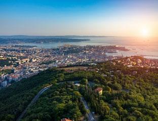
Miramare
Contovello
2
1
Per tutti
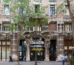
I triestini chiamano questo viale, autentica arteria pedonale, con il nome di acquedoto in virtù della presenza sotterranea della rete di approvvigionamento idrico voluta dall’imperatrice Maria Teresa nella seconda metà del ‘700. Partendo da largo don Bonifacio nei pressi dei portici di Chiozza, si muovono i passi attraversando una zona che negli anni Sessanta veniva percorsa avanti e indietro dai triestini, in quelle che, mutuando l’affermazione dal nuoto, vengono definite “vasche”. Inoltre, lungo il viale ci si può imbattere in alcune osterie che mantengono ancora oggi il loro carattere autentico. Nei pressi dell’estremità nord, si trova il palazzo dove nacque una delle birre più famose al mondo, la Dreher. L’antico stabilimento oggi è sede dell’Agenzia delle Entrate.
Barcola
For all
Locals call this pedestrian lane acquedoto [aqueduct, N/T], because it runs right above the water-main network that Empress Maria Theresa had built underneath the city ground in the second half of the 18th century. Starting from Largo Don Bonifacio, right next to the arcade called “Volti di Chiozza”, one enters an area that used to be Trieste’s pedestrian city centre in the Sixties, when Triestini would take many a leisure stroll walking up and down this series of parallel streets, called “vasche” [i.e. swimming pool lengths, N/T]. Here and there along the main boulevard you can still find a number of osterie, traditional taverns that still preserve their authentic character. Heading North, you will eventually reach the building where world-renowned Dreher beer was born, and hosting today one of the offices of Agenzia delle Entrate [Italian Revenue Agency, N/T].
IN THE CITY
Gretta
Conconello
3
Via di Cologna
Viale XX Settembre
1
Una passeggiata vicino al mare, lungo la riviera di Barcola dove far scomparire i pensieri legati al quotidiano. Partendo da piazzale 11 settembre e seguendo la linea di costa in circa un’oretta si giunge al castello di Miramare, passando il Cedas, lo stabilimento gratuito chiamato “Topolini” e la Marinella. Ma al di là della splendida conclusione con il bianco maniero, un’attenzione particolare merita la pineta di Barcola, piantata dopo la Seconda Guerra Mondiale e che i triestini deridevano con l’inconfondibile autoironia locale. Oggi questo bosco sul mare offre alcuni locali tipici, un po’ d’ombra durante la canicola estiva per picnic di gruppi di giovani e famigliole e un’area da percorrere in lungo e in largo, lasciandosi alle spalle le fatiche del giorno.
A walk along the waterfront, on Barcola’s riviera, is all you need to forget all about the trials and tribulations of everyday life. Starting from the square Piazzale 11 Settembre a one-hour walk along the coast line leads you through Cedas marina, Topolini free bathing establishment and La Marinella seafood restaurant, all the way to Miramare Castle. The manor’s pure white walls are the perfect grand finale of this itinerary, but on your way there you may want to linger in the cool shade of La Pineta, Barcola’s pine grove planted after World War II much to the amusement of Triestini, who used to smirk at the sight of those tiny trees, true to the jabbering nature of local peoples. Today this pine grove on the sea line is populated with traditional taverns, many shaded spots perfect for a family picnic or a cold drink with friends on a hot summer day, and a network of walk paths where you can shake off the stress at the end of a working day.

3
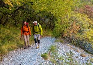
Per chi ha fiato e gambe
Partite dal piazzale poco prima dell’abitato di Ferlugi/ Conconello e seguite il sentiero che conduce allo stagno. Dopo poco, sulla destra troverete un’antica traccia in discesa da percorrere interamente fino all’intersezione con strada nuova per Opicina. Prendete via dei Baiardi, che si trova dall’altro lato della strada, e girate immediatamente a sinistra lungo via Clivo Artemisio. Dopo circa 300 metri, dopo aver oltrepassato un ponte della vecchia linea ferroviaria che portava a Vienna, girate a destra lungo via Fleming e spingetevi fino in fondo alla strada. Alla fine, girate ancora a destra lungo una vecchia mulattiera abbandonata ma percorribile. Sbucherete in salita monte Valerio e, in conclusione in via Cologna. L’itinerario fa parte degli antichi sentieri che le donne slovene del Carso percorrevano a piedi per portare il latte (mleko in sloveno) alle famiglie borghesi della Trieste che fu. Insomma, la via delle mlekarice, le donne del latte.
For expert walkers
Starting from the little square in front of the residential area of Ferlugi/Conconello, follow the path leading to the pond. Ahead, on your right, you will see an old track running downhill all the way to the crossroad intersecting Strada Nuova per Opicina. Here cross the road and take Via dei Baiardi, immediately turning left into Via Clivo Artemisio. Proceed for approximately 300 metres, crossing the bridge over the old railroad that used to connect Trieste to Vienna, and then turn right into Via Fleming. At the end of the road, on your right, an old mule track, now abandoned but still in good condition, leads to Salita Monte Valerio, eventually reaching Via Cologna. This itinerary was once trodden by Slovene women, who used to come down the Karst to bring milk (Slovenian: mleko) to the gentry families of Trieste hence its colloquial name Via delle Mlekarice, the road of the milk women.
IN THE OUTSKIRTS 5
4 Dalla birra Dreher all’antico borgo di Cattinara. Esiste un bosco immerso nella città di Trieste che si chiama Cacciatore, ma che per tutti i triestini sarà solo ed esclusivamente “el boschetto”. Proprio dietro la vecchia fabbrica della Dreher inizia un dedalo di sentieri che conduce in direzione dell’abitato di Cattinara, che prima dell’edificazione del principale ospedale triestino, manteneva le caratteristiche rurali di un piccolo borgo. La bellezza di questo itinerario sta un po’ nel perdersi lungo i sentieri, senza mai perdere di vista Cattinara. A pochi passi dall’ospedale si trova infatti uno dei cimiteri più antichi di Trieste, dove hanno diritto a essere seppelliti solamente i residenti dei rioni di Cattinara e Longera. Gironzolare tra le lapidi può restituire l’immagine di una Trieste diversa, vista l’alta concentrazione di cognomi sloveni presenti all’interno di questo piccolo camposanto. Boschetto Barcola Borgo Grotta Gigante
Obelisco Monte Grisa Borgo San Nazario
Opicina Prosecco
From Dreher beer to the old village of Cattinara. In the heart of Trieste grows a forest called Cacciatore [Hunter, N/T], but known among the Triestini simply as “el boschetto” [the little wood, N/T]. Behind Dreher’s old factory a maze of pathways unfolds in the direction of Cattinara’s residential area, which used to resemble all the other little villages, or borghi, surrounding the city, until Trieste’s main hospital was built here. The beauty of following this itinerary is letting oneself get lost in the maze, keeping Cattinara hospital as your only reference point. Next to the hospital one of Trieste’s oldest cemeteries hosts only the remains of those who have lived in the districts of Cattinara and Longera. The many Slovenian family names that populate the gravestones of this little graveyard tell the story of a different Trieste.
Padriciano
San Giacomo
Servola
Longera
6
Cimitero di Cattinara
Servola

Dal piazzale dell’obelisco a Opicina muovetevi in direzione del santuario di monte Grisa e dell’abitato di San Nazario. Il sentiero è di una facilità estrema ed è luogo particolarmente amato dai triestini, anche per la leggenda ispirata a un improbabile passaggio napoleonico, quando le truppe del Corso occuparono Trieste alla fine del Settecento. Al di là della narrazione, alcuni scorci regalano panorami mozzafiato, come d’altronde la presenza di un bosco fitto che protegge dall’inquietudine quotidiana. Una volta giunti sotto le falesie carsiche potrete incrociare giovani che arrampicano e, una volta in paese, fermatevi nella prima osteria che trovate sulla destra, gestita da una famiglia di profughi istriani dove si conserva ancora il ricordo di un Carso particolare. Borgo San Nazario è infatti uno dei tanti borghi costruiti appositamente per dare ospitalità agli istriani, giunti a Trieste nel Secondo Dopoguerra.
From Opicina obelisk square head towards the Sanctuary of Monte Grisa and the residential area of San Nazario. It is an easy-level walk and one of Triestini’s favourite places, perhaps also because of a legend claiming that Napoleon passed through here, when his troops occupied Trieste at the end of the 18 th century. Facts and fantasies aside, this itinerary surely offers some breathtaking glimpses of the surrounding landscapes where the vegetation thins out everywhere else the trees grow high and thick, forming an impenetrable wall that guards this place from the humdrum routine of city life. Once you reach the cliffs of the Karst Plateau, habitual destination of rock climbers, continue to the village of Borgo San Nazario, and enjoy a restorative stop at the first osteria you see on your right: the tavern is run by a family of Istrian refugees, whose recipes still preserve the charm of the Karst as it used to be. Indeed, Borgo San Nazario is one of the many Karst towns built to provide shelter to Istrian refugees, who fled to Trieste in the aftermath of World War II.
6

Per chi ha buone gambe
Campo San Giacomo, la piazza principale di uno dei rioni più popolosi di tutta la città. È da qui che si possono infilare gli scarponi e dirigersi verso la pista ciclopedonale che conduce fino alla zona della val Rosandra. È a tutti gli effetti una passeggiata semplice, non tremendamente impegnativa, che si può interrompere in qualsiasi momento ma che è in grado di regalare una bretella tra l’area urbana e quella della periferia naturale. Si passa dal colorato caos di San Giacomo, rione preferito dalla storica comunità serba della città, al silenzio del bosco, interrotto solamente dal rumore di qualche bicicletta o di invisibili passeriformi. Un itinerario per chi ama sovrapporre le storie, e legare le diverse identità di Trieste, o di Trst, che dir si voglia.
For skilled walkers
Campo San Giacomo is the name of the main square of one of Trieste’s most densely populated rioni [districts N/T]. Lace your walking shoes and head to the pedestrian and bike path that runs into Val Rosandra. This fairly easy walk connects the city to its natural backyard, offering numerous resting areas along the way. Leaving behind the colourful chaos of San Giacomo, you will soon be entering the soothing silence of the woods, interrupted here and there by the sound of a bicycle’s wheels or the call of a sparrow. An itinerary to discover the many layers of this land’s history and draw a line connecting the many identities of Trieste, or Trst, depending on the name you prefer.
Monte Hermada
8
Ceroglie
Sistiana
Aurisina
7
Santa Croce
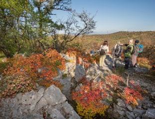
Le piante aromatiche del Carso a volte danno il nome ad antiche tracce utilizzate per secoli. È questo il caso della salvia che diventa protagonista di uno dei sentieri più suggestivi di tutta la provincia di Trieste. Dall’abitato sloveno di Santa Croce si snoda un itinerario poco faticoso ma di una bellezza disarmante, a picco sul mare dove i pescatori, fino a qualche decennio fa, erano soliti riunirsi per la pesca del tonno. La traccia, dalla quale un tempo avremmo potuto ammirare l’ebollizione del golfo al passaggio dei grandi banchi pelagici –”el mar che boi” direbbero i tržačani, i triestini di lingua slovena– conduce all’abitato di Aurisina, dopo circa un’ora di passi circondati dalla salvia, dall’elicriso, dal timo e da quel particolare profumo simile al caffè che l’euforbia produce.
There are old trails on the Karst Plateau named after the herbs that grow on their sides. Sage, for instance, is the name of one of the most beautiful trails of Trieste and its surroundings. From the Slovene enclave of Santa Croce an easy walk leads you to a cliff side that dives into the sea, in a landscape of disarming beauty, where a few decades ago fishermen used to gather for tuna fishing. Once you could see the Gulf waters churning from here, as schools of large pelagic fish made their way to the coast “el mar che boi” [the sea that boils, N/T] as Tržačani [Slovenian-speaking Triestini] would say. The trail leads to the town of Aurisina, a one-hour walk surrounded by sage, red everlasting, thyme, and that coffee-like distinct scent of spurge.
IN THE LANDSCAPE
Molo Audace
Trieste
Padriciano
San Giacomo
9
Muggia
Foiba di Basovizza
Val Rosandra
Škofije
8
Per chi ha buone gambe
Sulla cima del monte Hermada, ai confini settentrionali della provincia di Trieste, non c’è traccia di memoria. Questa altura di 323 metri sul livello del mare rappresentò infatti la roccaforte difensiva per le truppe austroungariche durante il primo conflitto mondiale e, ad oggi, poche sono le persone che si interessano di questo pezzo dimenticato dalla storia ufficiale, quella scritta come sempre dai vincitori. La cima di questa collina si può raggiungere da diverse località. Da Malchina si può prendere il sentiero che si trova nella parte nord dell’abitato e da qui seguire una lunga traccia che conduce fino all’intersezione con la strada bianca proveniente da Ceroglie. Da questo bivio si inizia a salire fino a toccare con mano la prima linea del fronte del Carso. Fritz Weber, ufficiale austroungarico che pubblicò le sue memorie in Tappe della disfatta, dedicò all’Ermada –si può scrivere anche così, oppure Grmada, non fa differenza– alcune pagine del racconto degli anni passati in guerra. Una narrazione che riporta ad un periodo, per tutta questa zona, terrificante.
For skilled walkers
On the top of Monte Hermada –also known as Ermada and Grmada– one of the hills in the northern part of Trieste’s province, there is no memory. Here, at 323 metres above sea levels, Austro-Hungarian troops built their defensive stronghold during World War I. Today, few care about this fragment of history, a feeble voice, drowned by the fanfare of the winners. The hilltop can be reached through various routes: from the little farmers’ village of Malchina, for instance, a path running northward leads to a crossroad with a dirt track coming down from the village of Ceroglie. Heading uphill from here, the trail leads to the first line of the Karst front. AustroHungarian army official Fritz Weber, whose memoires were published in the book Das Ende der alten Armee [The end of the old army, N/T], writes about Mount Hermada in his account of the war a chilling testimony of the tragic years that these lands went through.

Nel riassunto dei cammini orientali, emerge con forza la cinque giorni organizzata dalla Compagnia dei Cammini che, grazie alle parole e ai passi di Luigi Nacci, organizza il periplo del Carso. Si parte da molo Audace –già molo San Carlo– e si penetra all’interno del ventre di Trieste, mescolandosi tra i serbi del rione di San Giacomo, puntando dritti verso la val Rosandra –o Glinščica– e poi via verso i drammi del Novecento. La foiba di Basovizza, il campo profughi di Padriciano, la Prima e la Seconda Guerra Mondiale, le occupazioni e i tormenti di una città strana, difficile e per certi versi indomabile. Si cammina sottoterra, tra grotte, cavità e cunicoli, si ascoltano ospiti che parlano il dialetto, si immaginano silenzi e si rispettano le espressioni sonore a noi poco familiari. Sono cinque giorni in grado in regalare agli occhi una scintillante curiosità nei confronti di una terra divisa, dove le ferite del tempo si stanno lentamente rimarginando; un centinaio di chilometri per avvicinarsi alla comprensione di qualche centinaio di anni. Dovrebbero essere sufficienti, soprattutto per chi qui arriva con lo sguardo del viaggiatore.
One of the most impressive Eastern Trails in this area is the five-day trail circumnavigating the Karst Plateau, organised by the association Compagnia dei Cammini, especially thanks to one of its members, wayfarer and writer Luigi Nacci. Starting from Molo Audace (formerly known as Molo San Carlo) the trail enters the very heart of the city centre, through the Serbian neighbourhood of rione San Giacomo, leading towards the mouth of Val Rosandra (or Glinščica) and the memories of the 20 th century horrors. Basovizza Foiba, Padriciano’s refugee camp, World Wars I and II, and the occupation and torments of a strange, difficult, somehow indomitable city. The trail here dives underground, through caves, sinkholes, and tunnels, and along the way visitors are told the stories of these places by their dialect-speaking hosts, while imagining their silence, and respectfully listening to unfamiliar sounds and expressions. Five days that kindle a genuine interest in these divided lands, where past wounds are slowly healing. One hundred kilometres that shed some light on a turbulent century. It should be enough, at least for those who come here with a traveller’s spirit.
1
Per tutti
I triestini chiamano questo viale, autentica arteria pedonale, con il nome di acquedoto in virtù della presenza sotterranea della rete di approvvigionamento idrico voluta dall’imperatrice Maria Teresa nella seconda metà del ‘700. Partendo da largo don Bonifacio nei pressi dei portici di Chiozza, si muovono i passi attraversando una zona che negli anni Sessanta veniva percorsa avanti e indietro dai triestini, in quelle che, mutuando l’affermazione dal nuoto, vengono definite “vasche”. Inoltre, lungo il viale ci si può imbattere in alcune osterie che mantengono ancora oggi il loro carattere autentico. Nei pressi dell’estremità nord, si trova il palazzo dove nacque una delle birre più famose al mondo, la Dreher. L’antico stabilimento oggi è sede dell’Agenzia delle Entrate.
For all
Locals call this pedestrian lane acquedoto [aqueduct, N/T], because it runs right above the water-main network that Empress Maria Theresa had built underneath the city ground in the second half of the 18th century. Starting from Largo Don Bonifacio, right next to the arcade called “Volti di Chiozza”, one enters an area that used to be Trieste’s pedestrian city centre in the Sixties, when Triestini would take many a leisure stroll walking up and down this series of parallel streets, called “vasche” [i.e. swimming pool lengths, N/T]. Here and there along the main boulevard you can still find a number of osterie, traditional taverns that still preserve their authentic character. Heading North, you will eventually reach the building where world-renowned Dreher beer was born, and hosting today one of the offices of Agenzia delle Entrate [Italian Revenue Agency, N/T].

2
Per chi ha buone gambe
Una passeggiata vicino al mare, lungo la riviera di Barcola dove far scomparire i pensieri legati al quotidiano. Partendo da piazzale 11 settembre e seguendo la linea di costa in circa un’oretta si giunge al castello di Miramare, passando il Cedas, lo stabilimento gratuito chiamato “Topolini” e la Marinella. Ma al di là della splendida conclusione con il bianco maniero, un’attenzione particolare merita la pineta di Barcola, piantata dopo la Seconda Guerra Mondiale e che i triestini deridevano con l’inconfondibile autoironia locale. Oggi questo bosco sul mare offre alcuni locali tipici, un po’ d’ombra durante la canicola estiva per picnic di gruppi di giovani e famigliole e un’area da percorrere in lungo e in largo, lasciandosi alle spalle le fatiche del giorno.
For skilled walkers
A walk along the waterfront, on Barcola’s riviera, is all you need to forget all about the trials and tribulations of everyday life. Starting from the square Piazzale 11 Settembre a one-hour walk along the coast line leads you through Cedas marina, Topolini free bathing establishment and La Marinella seafood restaurant, all the way to Miramare Castle. The manor’s pure white walls are the perfect grand finale of this itinerary, but on your way there you may want to linger in the cool shade of La Pineta, Barcola’s pine grove planted after World War II much to the amusement of Triestini, who used to smirk at the sight of those tiny trees, true to the jabbering nature of local peoples. Today this pine grove on the sea line is populated with traditional taverns, many shaded spots perfect for a family picnic or a cold drink with friends on a hot summer day, and a network of walk paths where you can shake off the stress at the end of a working day.

3
Per chi ha fiato e gambe
Partite dal piazzale poco prima dell’abitato di Ferlugi/ Conconello e seguite il sentiero che conduce allo stagno. Dopo poco, sulla destra troverete un’antica traccia in discesa da percorrere interamente fino all’intersezione con strada nuova per Opicina. Prendete via dei Baiardi, che si trova dall’altro lato della strada, e girate immediatamente a sinistra lungo via Clivo Artemisio. Dopo circa 300 metri, dopo aver oltrepassato un ponte della vecchia linea ferroviaria che portava a Vienna, girate a destra lungo via Fleming e spingetevi fino in fondo alla strada. Alla fine, girate ancora a destra lungo una vecchia mulattiera abbandonata ma percorribile. Sbucherete in salita monte Valerio e, in conclusione in via Cologna. L’itinerario fa parte degli antichi sentieri che le donne slovene del Carso percorrevano a piedi per portare il latte (mleko in sloveno) alle famiglie borghesi della Trieste che fu. Insomma, la via delle mlekarice, le donne del latte.
For expert walkers
Starting from the little square in front of the residential area of Ferlugi/Conconello, follow the path leading to the pond. Ahead, on your right, you will see an old track running downhill all the way to the crossroad intersecting Strada Nuova per Opicina. Here cross the road and take Via dei Baiardi, immediately turning left into Via Clivo Artemisio. Proceed for approximately 300 metres, crossing the bridge over the old railroad that used to connect Trieste to Vienna, and then turn right into Via Fleming. At the end of the road, on your right, an old mule track, now abandoned but still in good condition, leads to Salita Monte Valerio, eventually reaching Via Cologna. This itinerary was once trodden by Slovene women, who used to come down the Karst to bring milk (Slovenian: mleko) to the gentry families of Trieste hence its colloquial name Via delle Mlekarice, the road of the milk women.

4
Per chi ha fiato e gambe
Dalla birra Dreher all’antico borgo di Cattinara. Esiste un bosco immerso nella città di Trieste che si chiama Cacciatore, ma che per tutti i triestini sarà solo ed esclusivamente “el boschetto”. Proprio dietro la vecchia fabbrica della Dreher inizia un dedalo di sentieri che conduce in direzione dell’abitato di Cattinara, che prima dell’edificazione del principale ospedale triestino, manteneva le caratteristiche rurali di un piccolo borgo. La bellezza di questo itinerario sta un po’ nel perdersi lungo i sentieri, senza mai perdere di vista Cattinara. A pochi passi dall’ospedale si trova infatti uno dei cimiteri più antichi di Trieste, dove hanno diritto a essere seppelliti solamente i residenti dei rioni di Cattinara e Longera. Gironzolare tra le lapidi può restituire l’immagine di una Trieste diversa, vista l’alta concentrazione di cognomi sloveni presenti all’interno di questo piccolo camposanto.
For expert walkers
From Dreher beer to the old village of Cattinara. In the heart of Trieste grows a forest called Cacciatore [Hunter, N/T], but known among the Triestini simply as “el boschetto” [the little wood, N/T]. Behind Dreher’s old factory a maze of pathways unfolds in the direction of Cattinara’s residential area, which used to resemble all the other little villages, or borghi, surrounding the city, until Trieste’s main hospital was built here. The beauty of following this itinerary is letting oneself get lost in the maze, keeping Cattinara hospital as your only reference point. Next to the hospital one of Trieste’s oldest cemeteries hosts only the remains of those who have lived in the districts of Cattinara and Longera. The many Slovenian family names that populate the gravestones of this little graveyard tell the story of a different Trieste.

5
Per tutti
Dal piazzale dell’obelisco a Opicina muovetevi in direzione del santuario di monte Grisa e dell’abitato di San Nazario. Il sentiero è di una facilità estrema ed è luogo particolarmente amato dai triestini, anche per la leggenda ispirata a un improbabile passaggio napoleonico, quando le truppe del Corso occuparono Trieste alla fine del Settecento. Al di là della narrazione, alcuni scorci regalano panorami mozzafiato, come d’altronde la presenza di un bosco fitto che protegge dall’inquietudine quotidiana. Una volta giunti sotto le falesie carsiche potrete incrociare giovani che arrampicano e, una volta in paese, fermatevi nella prima osteria che trovate sulla destra, gestita da una famiglia di profughi istriani dove si conserva ancora il ricordo di un Carso particolare. Borgo San Nazario è infatti uno dei tanti borghi costruiti appositamente per dare ospitalità agli istriani, giunti a Trieste nel Secondo Dopoguerra.
For all
From Opicina obelisk square head towards the Sanctuary of Monte Grisa and the residential area of San Nazario. It is an easy-level walk and one of Triestini’s favourite places, perhaps also because of a legend claiming that Napoleon passed through here, when his troops occupied Trieste at the end of the 18 th century. Facts and fantasies aside, this itinerary surely offers some breathtaking glimpses of the surrounding landscapes where the vegetation thins out everywhere else the trees grow high and thick, forming an impenetrable wall that guards this place from the humdrum routine of city life. Once you reach the cliffs of the Karst Plateau, habitual destination of rock climbers, continue to the village of Borgo San Nazario, and enjoy a restorative stop at the first osteria you see on your right: the tavern is run by a family of Istrian refugees, whose recipes still preserve the charm of the Karst as it used to be. Indeed, Borgo San Nazario is one of the many Karst towns built to provide shelter to Istrian refugees, who fled to Trieste in the aftermath of World War II.

6
Per chi ha buone gambe
Campo San Giacomo, la piazza principale di uno dei rioni più popolosi di tutta la città. È da qui che si possono infilare gli scarponi e dirigersi verso la pista ciclopedonale che conduce fino alla zona della val Rosandra. È a tutti gli effetti una passeggiata semplice, non tremendamente impegnativa, che si può interrompere in qualsiasi momento ma che è in grado di regalare una bretella tra l’area urbana e quella della periferia naturale. Si passa dal colorato caos di San Giacomo, rione preferito dalla storica comunità serba della città, al silenzio del bosco, interrotto solamente dal rumore di qualche bicicletta o di invisibili passeriformi. Un itinerario per chi ama sovrapporre le storie, e legare le diverse identità di Trieste, o di Trst, che dir si voglia.
For skilled walkers
Campo San Giacomo is the name of the main square of one of Trieste’s most densely populated rioni [districts N/T]. Lace your walking shoes and head to the pedestrian and bike path that runs into Val Rosandra. This fairly easy walk connects the city to its natural backyard, offering numerous resting areas along the way. Leaving behind the colourful chaos of San Giacomo, you will soon be entering the soothing silence of the woods, interrupted here and there by the sound of a bicycle’s wheels or the call of a sparrow. An itinerary to discover the many layers of this land’s history and draw a line connecting the many identities of Trieste, or Trst, depending on the name you prefer.

IN THE LANDSCAPE
7
Per tutti
Le piante aromatiche del Carso a volte danno il nome ad antiche tracce utilizzate per secoli. È questo il caso della salvia che diventa protagonista di uno dei sentieri più suggestivi di tutta la provincia di Trieste. Dall’abitato sloveno di Santa Croce si snoda un itinerario poco faticoso ma di una bellezza disarmante, a picco sul mare dove i pescatori, fino a qualche decennio fa, erano soliti riunirsi per la pesca del tonno. La traccia, dalla quale un tempo avremmo potuto ammirare l’ebollizione del golfo al passaggio dei grandi banchi pelagici – ”el mar che boi” direbbero i tržačani, i triestini di lingua slovena– conduce all’abitato di Aurisina, dopo circa un’ora di passi circondati dalla salvia, dall’elicriso, dal timo e da quel particolare profumo simile al caffè che l’euforbia produce.
For all
There are old trails on the Karst Plateau named after the herbs that grow on their sides. Sage, for instance, is the name of one of the most beautiful trails of Trieste and its surroundings. From the Slovene enclave of Santa Croce an easy walk leads you to a cliff side that dives into the sea, in a landscape of disarming beauty, where a few decades ago fishermen used to gather for tuna fishing. Once you could see the Gulf waters churning from here, as schools of large pelagic fish made their way to the coast “el mar che boi” [the sea that boils, N/T] as Tržačani [Slovenian-speaking Triestini] would say. The trail leads to the town of Aurisina, a one-hour walk surrounded by sage, red everlasting, thyme, and that coffee-like distinct scent of spurge.


8
Per chi ha buone gambe
Sulla cima del monte Hermada, ai confini settentrionali della provincia di Trieste, non c’è traccia di memoria. Questa altura di 323 metri sul livello del mare rappresentò infatti la roccaforte difensiva per le truppe austroungariche durante il primo conflitto mondiale e, ad oggi, poche sono le persone che si interessano di questo pezzo dimenticato dalla storia ufficiale, quella scritta come sempre dai vincitori. La cima di questa collina si può raggiungere da diverse località. Da Malchina si può prendere il sentiero che si trova nella parte nord dell’abitato e da qui seguire una lunga traccia che conduce fino all’intersezione con la strada bianca proveniente da Ceroglie. Da questo bivio si inizia a salire fino a toccare con mano la prima linea del fronte del Carso. Fritz Weber, ufficiale austroungarico che pubblicò le sue memorie in Tappe della disfatta, dedicò all’Ermada – si può scrivere anche così, oppure Grmada, non fa differenza– alcune pagine del racconto degli anni passati in guerra. Una narrazione che riporta ad un periodo, per tutta questa zona, terrificante.
For skilled walkers
On the top of Monte Hermada –also known as Ermada and Grmada– one of the hills in the northern part of Trieste’s province, there is no memory. Here, at 323 metres above sea levels, Austro-Hungarian troops built their defensive stronghold during World War I. Today, few care about this fragment of history, a feeble voice, drowned by the fanfare of the winners. The hilltop can be reached through various routes: from the little farmers’ village of Malchina, for instance, a path running northward leads to a crossroad with a dirt track coming down from the village of Ceroglie. Heading uphill from here, the trail leads to the first line of the Karst front. Austro- Hungarian army official Fritz Weber, whose memoires were published in the book Das Ende der alten Armee [The end of the old army, N/T], writes about Mount Hermada in his account of the war a chilling testimony of the tragic years that these lands went through.

9
Per chi ha fiato e gambe
Nel riassunto dei cammini orientali, emerge con forza la cinque giorni organizzata dalla Compagnia dei Cammini che, grazie alle parole e ai passi di Luigi Nacci, organizza il periplo del Carso. Si parte da molo Audace –già molo San Carlo– e si penetra all’interno del ventre di Trieste, mescolandosi tra i serbi del rione di San Giacomo, puntando dritti verso la val Rosandra –o Glinščica– e poi via verso i drammi del Novecento. La foiba di Basovizza, il campo profughi di Padriciano, la Prima e la Seconda Guerra Mondiale, le occupazioni e i tormenti di una città strana, difficile e per certi versi indomabile. Si cammina sottoterra, tra grotte, cavità e cunicoli, si ascoltano ospiti che parlano il dialetto, si immaginano silenzi e si rispettano le espressioni sonore a noi poco familiari. Sono cinque giorni in grado in regalare agli occhi una scintillante curiosità nei confronti di una terra divisa, dove le ferite del tempo si stanno lentamente rimarginando; un centinaio di chilometri per avvicinarsi alla comprensione di qualche centinaio di anni. Dovrebbero essere sufficienti, soprattutto per chi qui arriva con lo sguardo del viaggiatore.
For expert walkers
One of the most impressive Eastern Trails in this area is the five-day trail circumnavigating the Karst Plateau, organised by the association Compagnia dei Cammini, especially thanks to one of its members, wayfarer and writer Luigi Nacci. Starting from Molo Audace (formerly known as Molo San Carlo) the trail enters the very heart of the city centre, through the Serbian neighbourhood of rione San Giacomo, leading towards the mouth of Val Rosandra (or Glinščica) and the memories of the 20 th century horrors. Basovizza Foiba, Padriciano’s refugee camp, World Wars I and II, and the occupation and torments of a strange, difficult, somehow indomitable city. The trail here dives underground, through caves, sinkholes, and tunnels, and along the way visitors are told the stories of these places by their dialect-speaking hosts, while imagining their silence, and respectfully listening to unfamiliar sounds and expressions. Five days that kindle a genuine interest in these divided lands, where past wounds are slowly healing. One hundred kilometres that shed some light on a turbulent century. It should be enough, at least for those who come here with a traveller’s spirit.


