
22 minute read
2.1 Definitions of the main terms
2EXPERT BASIS
For a broader and harmonised understanding of the GI concept, some clarifications and definitions of the main terms need to be provided, such as, for example, what GI is, what its main spatial elements are, as well as its functions.
Advertisement
The implementation of the GI, which includes recognition and planning, is a process in which the analyses from spatial data may be helpful. This is why this chapter deals with the technical and methodological starting points for the preparation and analysis of the spatial data for recognising the GI, as well as the proposal of the process for planning the GI. The handbook’s appendix provides expert clarification of the specific recognition method, and the process for planning the GI in an environment.
The GI implementation must, of course, be in line with the legal order and procedure, especially in the areas of strategic and spatial planning. The various administrative and spatial levels of legal arrangements must also be considered, from the local level all the way to the level of the European community and beyond. This is why this chapter is concluded with the provision of the legal starting points. Because these are broad, the legal bases and recommendations for supporting the implementation of the GI are presented in detail in the handbook’s appendix.
In this chapter, we list the definitions of the main terms: GI, ecosystem services (hereinafter: ES), spatial recognition and planning levels for GI and the green and blue corridors.
Because there are many planners and beneficiaries of the GI, and because their viewpoints regarding the theoretical and practical aspects of the GI may vary, the GI may be identified in many ways. Since the GI concept and its broad understanding are still being developed, we tend to avoid using the term “definition”, which the user could understand as a final, widely accepted understanding. Even the European Commission used the term “working definition” when it explained the GI. This working definition of the European Commission, which is provided below, is most often used in the Slovenian and international space.
2.1 Definitions of the main terms
2.1.1 The definition of green infrastructure
The identification or working definition of the European Commission (2013).
The message of the Committee from 2013 states: Many definitions of GI have been developed. It is therefore difficult to cover all aspects in one short paragraph. The following working definition will however be used for the purposes of this Communication: “Green Infrastructure is a strategically
planned network of natural and semi-natural areas with other environmental features designed and managed to deliver a wide range of ecosystem services. It incorporates green spaces (or blue if aquatic ecosystems are concerned) and other physical features in terrestrial (including coastal) and marine areas. On land, GI is present in rural and urban settings.”
The report from the Commission to the European Parliament, the European Council, the European Social and Economic Committee and the Committee of the Regions: Review of progress on implementation of the EU green infrastructure strategy [14.] states: “Unlike single-purpose grey infrastructure,
biodiversity-rich green spaces can perform a variety of extremely useful functions, often simultaneously and at very low cost, for the benefit of people, nature and the economy. In the EU, green infrastructure (GI) includes the Natura 2000 network as its backbone, as well as natural and semi-natural spaces outside Natura 2000, such as parks, private gardens, hedges, vegetated buffer strips along rivers, or structure-rich agricultural landscapes with certain features and practices, and artificial features such as green roofs, green walls, or ecobridges and fish ladders.”
In essence, the definition from the report is appropriate, because it is not limited only to areas, but also speaks of forming elements in spaces that are managed in order to ensure a wide spectre of ES. These are therefore also planned or formed and managed in parts of the environment which may also include facilities.
The table below provides and describes the various elements of the GI which may overlap, supplement each other, or form the GI together as a network of natural and semi-natural areas that ensure biodiversity and/or ecosystem services required by man.
Table 1: Green infrastructure elements with examples, made under Mazza et al. [15.]
GI ELEMENTS
Core natural areas
ES areas
Renewed or artificial natural areas or the ES areas
Green urban and suburban areas
Natural corridors/ links
Artificial corridors/ links
Areas with a high value of preserving biodiversity, which are usually protected, such as, for example, Natura 2000 and broader habitats, like the coastal area or vast grasslands.
Economically significant areas supplying ES (wood, food, drinking water), which are managed in a sustainable manner so that several other balancing and cultural ES are preserved. They may overlap with the core areas.
New habitat areas or renewed ecosystems for specific target types and/or increase of inventories of the target ES. They are actually an integral part of the previous two elements.
Parks, gardens, smaller forests, green walls and roofs, tree rows, sustainable rainwater collectors, ponds, even green schoolyards, cemeteries, small gardens.
Natural links, like rivers/creeks, natural linking tree zones, hedgerows, even stone walkways, all of which makes movement possible and improves the situation of species and even the inventory of ES. They are also called green or blue corridors.
Artificially generated links with the function of connecting the previous GI elements to allow the movement and migrations of species and to increase the ES inventories. For example, passages for fish, ecoducts across traffic roads, tunnels below traffic roads, etc. Artificial corridors establish the functionality of the green and blue corridors, and as such, are their integral part.
The issue in recognising the GI mainly concerns the question whether a certain area is a GI or not, or that areas may also be recognised as GI with various recognisability or value levels. In recent practices, the areas are recognised with a higher or lesser recognisability than GI, which was demonstrated, for example, by the Regional Workshop on Green Infrastructure and Ecological Connectivity [16.]. This handbook even recognises the GI in space with the help of a scale. The main goal when planning the GI is not just to preserve and increases biodiversity and the ES inventories in the existing GI areas, which are recognised as such with a higher added value, but also in areas which have been recognised as GI with a lower value level.
Photo 1: Sava river near Ljubljana creates a new, extensive water space with dynamic lateral erosion. It represents a connection between Danube salmon (Hucho hucho) and sand martin (Riparia riparia) habitats as well as human habitats.
An example of an artificial GI area is the reservoir near Kočevska Reka, which has been recognised as the feeding habitat of the white-tailed eagle, and the nearby forest is the forest reserve. The reservoir is an attractive fishing spot, and everything together is an attractive recreational tourist location. On the other hand, the area is also part of Natura 2000 due to several habitats and species. If the accumulation is removed, then we could lose a certain part of the biodiversity and some ES, but we would increase the habitats for target fish types due to the renewed natural hydro-morphology of the waters, such as, for example, the Mediterranean barbel (Barbus meridionalis) and the Balkan loach (Cobitis elongata). This could be comprehensively and successfully resolved by establishing the management of the GI and the natural resources.
2�1�2 Ecosystem services
Based on the current practice, there are many definitions and various international ES classifications, such as, for example, The Common International Classification of Ecosystem Services – CICES, The Millennium Ecosystem Assessment – MEA, etc. The latter, the Millennium Ecosystem Assessment Board (MEA), from 2005, is the one that is the most established internationally, and divides the ES into four categories [17.]: ΐ
ΐ PROVISIONING SERVICES: they provide food, water, wood and fibres as material or fuel, etc. REGULATING SERVICES: they affect the climate (e.g. carbon sinkhole), floods, diseases, the amount of waste and the quality of water (e.g. filtration of pollutants in surface waters), etc.
ΐ
CULTURAL SERVICES: they provide recreation, aesthetic and spiritual benefits, research and education, tourism potential, etc. ΐ SUPPORTING SERVICES: the generation of the soil, photosynthesis and the circulation of nutrients, etc.
There are no preservations of populations and habitats in the listed services which do, in fact, occur in some other classifications, like the RESI project classification [18.]. In general, we are proceeding from the viewpoint that a high biodiversity means higher inventories and ES diversity in a certain area, and vice versa. Because the GI includes areas in which we can recognise the function of preserving the endangered populations and habitats (nature conservation areas, etc.), and because biodiversity serves as the guarantee for certain, not yet recognised ES (medicines, research, balancing the number of certain species, etc.), we also included the preservation of populations and habitats into ES due to the recognition and planning of GI.
The division into four main ES categories in MEA has been checked in several studies. We often come across a critical assessment regarding the inclusion of the supporting services as a special category, mainly because supporting ES are more like consequential ES than directly used ES. This is why the standardised CICES classification omits this category, but the corresponding ES are adequately discussed in regulating services, which have been named “Regulation and maintenance services” in this case. Table 2 shows the aforementioned division of ES into three main categories.
Table 2: Categorisation of the ecosystem services
ES CATEGORIES ECOSYSTEM SERVICE
Provisioning services
Regulation and maintenance services Cultivating cultivated plants, pasture farming/grass as fodder, fishing and aquaculture, raw biotic materials (wood, fibres, etc.), water supply (drinking water/irrigation, process water, etc.), biomass for obtaining energy (from cultivated plants, forests), etc.
Retention of nutrients/substances, water purification, reduction in greenhouse gasses, alleviating drains and flood hazards, alleviating drought conditions, soil generation, regulating the local climate, improving air quality, preserving populations and habitats, etc.
Cultural services Landscape value, natural and cultural heritage, education and science, recreation and tourism (fishing, sailing, bathing, cycling, hiking), etc.
The inventory of each ES is interdependent. Inventories of some are being raised and supplemented (synergy), while the inventories of others clash. Example: if a certain area holds more wood (forest), then the same area will also serve as a bigger CO2 sinkhole, and will be able to retain more precipitation. And vice versa - areas with intensive farming or extensive cultivation of cultivated plants will hold less wood, tourism and the mitigation of high water drainages.
Inventories and demand for individual ES depend on the geographical peculiarities and the needs of the inhabitants, and are different from case to case. An example of the needs under certain ES, and for preserving their inventories, is provided in the table in Annex no. 1 - marked are the target ES, due to which a certain legal regime has been initially established, and the readers may think about the links between them (synergies and clashes) in specific cases. The table may also serve as a worksheet at harmonisation events, or when informing the public (local communities, schools, workshops) about ES and GI.
Figure 3 shows how the total ES inventory and the number of a certain target species changes with the change in the intensity of land use and the intensity of using certain ES. Let’s take this example: An area is being used extensively for the production of food (agriculture), which means that the usage of fertilisers and plant protection products is limited, the agricultural surfaces are covered with hedgerows, and the natural vegetation state is preserved on watercourses. The crop is not at its maximum, of course, and even the agricultural management is more expensive than in the case of intensive use. However, the inventory and the diversity of other ES, and the presence of the target types, remain high in such land use. It is different in intensive farming, where there are more crops, i.e. a high inventory of ES cultivating cultivated plants, but due to the over-exploitation of the area, this leads to a dwindling inventory of all the other ES, as well as lower biodiversity.
High Regulating ES (sum of components) Cultural ES (recreation & tourism) Cultural ES - spiritual, education (sum) Provisioning ES (max function) Illustrative Sum of ES values
MSA ... Mean Species Abundance Index
Low
MSA
Land use intensity gradient
Figure 3: Hypothetical interdependence between the intensity of land use, the index of the average number of species and the ES inventory in a certain area. Modified after [21.]
For the avoidance of doubt, the term “landscape services” (hereinafter: LS) needs to be mentioned, which is also used in specialised literature. LS is an even broader term than ES, because in addition to the services of “nature” and “ecosystems”, they also include services provided by the anthropogenic transformed area. Thus, LS also include accommodation, industrial production, extraction of minerals, production of food in greenhouses, etc. [19.] This handbook names these other landscape services as other landscape services. ES is a much more established term globally, and has also been clarified in
the MEA report - Ecosystems and human well-being [17.]. The terminology and typification of ES into four or three groups is widely recognised, which is why this handbook only uses the term ecosystem services, while other services, accommodation, traffic, etc., are named as other landscape services.

Photo 2: Wooden retaining wall or weir (“Kranjska stena”) is a traditional technique for erosion mitigation caused by water. Our ancestors used this technique in the construction of dams and mills to drive mills and sawmills. These arrangements do not endanger the local habitat but rather enrich it. For this reason, “Kranjska stena” is deservedly entered in the Register of Living Cultural Heritage of the Republic of Slovenia.
The supply of quality drinking water is one of the key human needs which landscape that is not intensively used may efficiently provide. Over-usage of ES and inadequate planning of other landscape usages (traffic, accommodation, industry, etc.) at a catchment area for drinking water, reduces the supply and increases the risk of water pollution. This is why the protection of the environment and the prevention of the possible risks of polluting or reducing water quantities need to be considered in the planning phase of the new rail connection between the coast and the hinterland (second railway track), and when seeking technically optimal and cost-efficient solutions The technical solution, which is more favourable investment-wise, may include a higher risk level for supplying water at the coast (the danger of spillages of hazardous substances, interruption of the underground water flows, etc.). This is why there may be higher costs to ensure an alternative supply of drinking water to the entire coastal region in the future, due to the pollution or a reduction in the water source flow. Such an alternative supply could require the construction of new pipelines from remote areas (even across the border) or desalinisation systems, which would additionally burden the landscape with objects and infrastructure, and would have a direct impact on the reduction in the value of the landscape and a negative indirect impact on the attractiveness for tourists. This is why the analyses of benefits and costs need to include the benefits provided by the natural area.
2�1�3 Levels: macro, mezzo, micro
We recognise and plan GI at various landscape levels, e.g. the cross-border, national and local levels. We have two methods for recognising and planning GI: ΐ
TOP-DOWN: recognising and harmonising planning that begins at a smaller scale, such as, for example, on the regional macro level, which is then “dropped” through the national mezzo level to the specific, municipal/local recognition and planning,
ΐ BOTTOM-UP: recognising and planning that begins on a large, detailed scale, for example on the level of the local community and its inhabitants, which is then “integrated” into smaller scales through the national into the regional scale.
Both methods are interrelated in practice and complement each other. If we wish to achieve solutions that will be efficient on various levels, then the GI planning process needs to include the decision-makers on the intergovernmental and macroregional level, on the strategic and on the local level, and good communication needs to be established between them.
EU and GLOBAL LEVEL MACRO LEVEL (strategic planning - macro regions) MEZZO LEVEL (strategic planning - river basin and cross border)
Strategic planning of GI Policies for conservation and planning of GI
MICRO LEVEL (the level of spatial planning)
Support in recognizing GI at higher spatial levels Recognizing GI
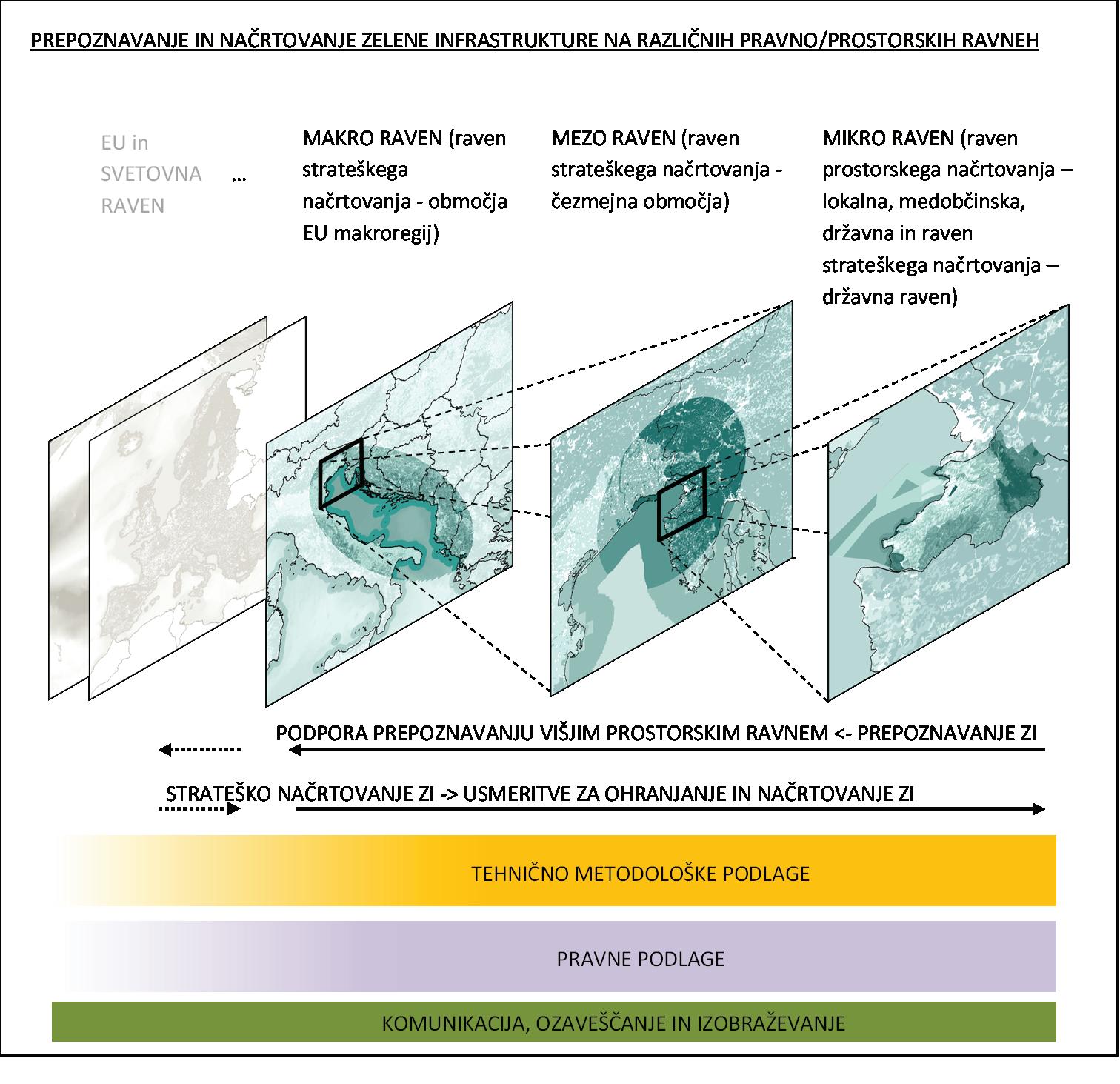
Communication, awarness and education
Tehnical and methodological basis
Legal basis
Figure 4: Recognising and planning GI at the various legal and landscape areas.
Macro level
The GI on the macro level is recognised and planned on the level of the EU macro regions. The GI implementation is an important goal of macroregional strategies and strategic programmes of the EU for the Adriatic-Ionian, Alpine and Danube regions. Without a harmonised plan to ensure ES on the macro/mezzo level, even the best situation at a certain micro area cannot ensure high and diverse inventories of ES. A good example is the Slovenian sea: because one part of the northern Adriatic, which falls under Slovenia, is
very small, and we are directly dependent on the strategies of the neighbouring countries, Italy and Croatia, in ensuring the quality of the sea environment. The precondition for a healthy natural environment in this case is to ensure sensible decisions of all the three countries and their good cooperation on the macroregional level.
Mezzo level
The GI on the mezzo level is recognised and planned in cross-border areas of the EU countries and in areas of individual river basins within the national state borders. Generally speaking, the national spatial strategy is also discussed at this level. The latter should also take into consideration the natural and geographical factors of a certain landscape, or even region [23.], when directing the spatial development, which generally dictate the adjustments of the inhabitants and the activity.
Micro level
Individual elements of the GI are recognised, preserved and renewed (as necessary) on the micro level, which ensure biodiversity, the main ES and the development of additional ES inventories. The latter may be recognised in a certain environment as a positive indicator for the development of a healthy environment for a better quality of life of people, and a good ecological situation of the habitats in each area.
When determining whether a certain situation is a macro, mezzo or micro level of decision-making and functioning, the terms “spatial and legal dimensions” need to be considered. The term “spatial dimension” relates directly to the size of the discussed area, while “legal dimensions” represent strategies, laws, etc., which need to be taken into account in a certain area. In practice, we often see cases in which the functioning needs to be on the macro level as well as on the micro level. Example: the Vipava river basin is not particularly vast, but it extends across two countries, Slovenia and Italy. The legal dimension in this case is the one due to which the interventions in this area must be planned on the cross-border mezzo level: the legal systems of both countries need to be observed.
Slovenia is relatively rich with waters and water sources - it is at the very top of the European countries in water richness. Even though a water protection area is secured by the state, the provision of drinking water is performed on the level of the municipalities (micro level). Most of the water supply in Slovenia is provided within the same river basin, where the municipality which depends on this water source is also situated. This does not apply for the Slovenian coast: in order to provide the coastal municipalities with sufficient drinking water, water will probably have to be brought from another river basin, which extends the issue to: (1) the state’s mezzo level, should we decide to preserve independence in the sense of water security and provide water ourselves from other available water sources, or (2) the cross-border mezzo level, should we obtain water from sources in the neighbouring countries (Croatia, Italy), whereby at least one part of the Slovenian territory becomes dependent on the decisions of the neighbouring countries. To achieve long-term stability regarding drinking water sources, global thinking is required (macro level), especially in recent times. The precipitation samples, their quantities and evaporation, all depend on the events on a (much) larger area; climate changes are global. Planning and harmonising strategies in such cases must therefore be performed on a regional macro level or even on a global level.
2�1�4 Green and blue corridors
The GI elements are also spatial or functional links - the so-called green and blue corridors (hereinafter: GBC) - between individual other GI elements, especially core areas. The main function of GBC is the migration of organisms in the various development stages. Green corridors are functional links on land, while blue corridors are present on waters, i.e. seas and inland waters; in some cases, the so-called stone walkways (Figure 5) serve as corridors. Organisms also move with material and energy flows between individual important natural areas that provide them with food and other conditions for their existence, such as reproduction, development and shelter. Even man seeks such corridors, because food supply in this area is higher; at sea, for example, such areas are those that have a richer fish presence. The additional support in recognising and managing GBC are the flows of materials and energies, human practices and other landscape facts.
The undisturbed ecological functions of GBC, the migration of organisms in all the development stages, and the transfer of materials and energies, all support the ecological functions and supply of ES in the core areas of GI. The opposite is also true - a good ecological situation in the core areas and their high biodiversity means that more organisms will migrate. The improvement of the functionality and moderate usage in GBC areas, together with core areas and other GI elements (Table 1), increase the inventory and diversity of ES (fishery, marine fish farming), which as such form a well preserved GI.
Palmanova
IT



gozd Panovec
Riserva Naturale Laghi di Doberdo i Pietrarossa SI
Riserva Naturale Regionale della Foce dell'Isonzo

Laguna di Marano e Grado
POTENCIALI ZA RAZVOJ ZELENE INFRASTRUKTURE V TRŽAŠKEM ZALIVU
Miramare
LEGENDA
reke in morje kot koridorji z regionalnim vplivom na razvoj zelene infrastrukutre in povezovanje zavarovanih območij ter kot prostor za povrnitev okrnjenih živalskih vrst kopenski migracijski koridorji, ki zagotavljajo potencial za razvoj intermodalnih rešitev zelene infrastrukture


zavarovana območja z regionalnim vplivom

območja Natura 2000 morski tokovi v Severnem Jadranu BIOGEOGRAFKSE REGIJE
kontinentalna biogeografska regija mediteranska biogeografska regija alpska biogeografska regija Debeli rtič soteska Glinščice
Krajinski park Strunjan Škocjanski zatok
Sečoveljske soline
idejna zasnova | dr. Mitja Bricelj kartografija | Andrej Bašelj, IzVRS
viri| ESRI, HERE, DeLormne, MapmyIndia © OpenStreetMap contributors and the GIS user community, wikipedia.org HR

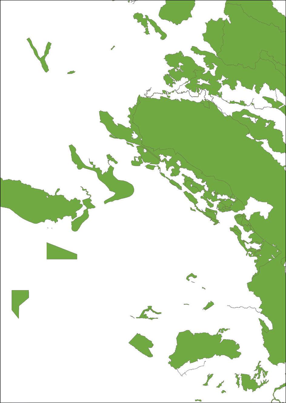
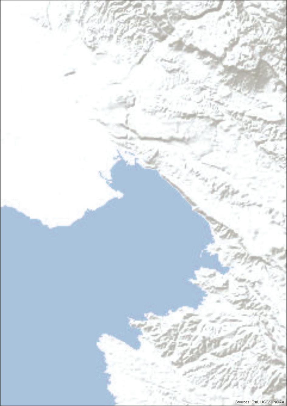
Figure 5: The display of the blue and green corridors (left image: The green potential and corridors at the Gulf of Trieste) and stonewalkways(imageright: the red colourrepresents a habitat of twoendangeredspecies of butterflies near theVipava river: the scarce large blue and the large copper; the Grevislin project). The corridors are an unbroken link between the GI areas, whilestonewalkwaysbreakoffinplaces.
In 2020, the Ministry of the Environment and Spatial Planning (MESP) organised several meetings in order to harmonise the sectoral views on GI and its implementation at sea and on the coast. These meetings were attended by experts in nature, spatial planning and water. Among other things, we agreed on the definition of green and blue corridors: “Green and blue corridors are the spatial link between green infrastructure areas that preserve or improve biodiversity and/or the inventory of ecosystem services”.
GBC can be discussed on all three levels: macro, mezzo and micro level. Corridors on the macro and mezzo level are recognised as the main general links where migrations of species, materials and energy take place. For example, the Danube river, as the regional stream, may be recognised as an inland blue corridor on the macro level. Concrete corridors are recognised and planned on the micro level, for example a natural mountain pass or ecoduct across a motorway in spatial planning processes.
In nature, the blue and green corridors often intertwine and pass from one to another. Let’s think about brackish waters, river deltas, wetland areas, etc. Even land organisms need water to survive. The transfer of materials and energy in nature is performed continuously. The motto in planning the green-blue corri-
dors, especially blue corridors, is to preserve the water continuum, i.e. the flow continuity of organisms, materials and energy from rivers and lakes inland, through the coastal areas and brackish waters to the sea and back.
Regarding the recognition and displays of the blue and green corridors in an area, it needs to be said that this is a generalisation. Namely, the line or zone of a certain width that represents a corridor in an area marks the highest probability of the occurrence of a certain indicative species or its migration path. There is, of course, a deviation from this line, because some members of a certain species may also appear at completely unexpected places.
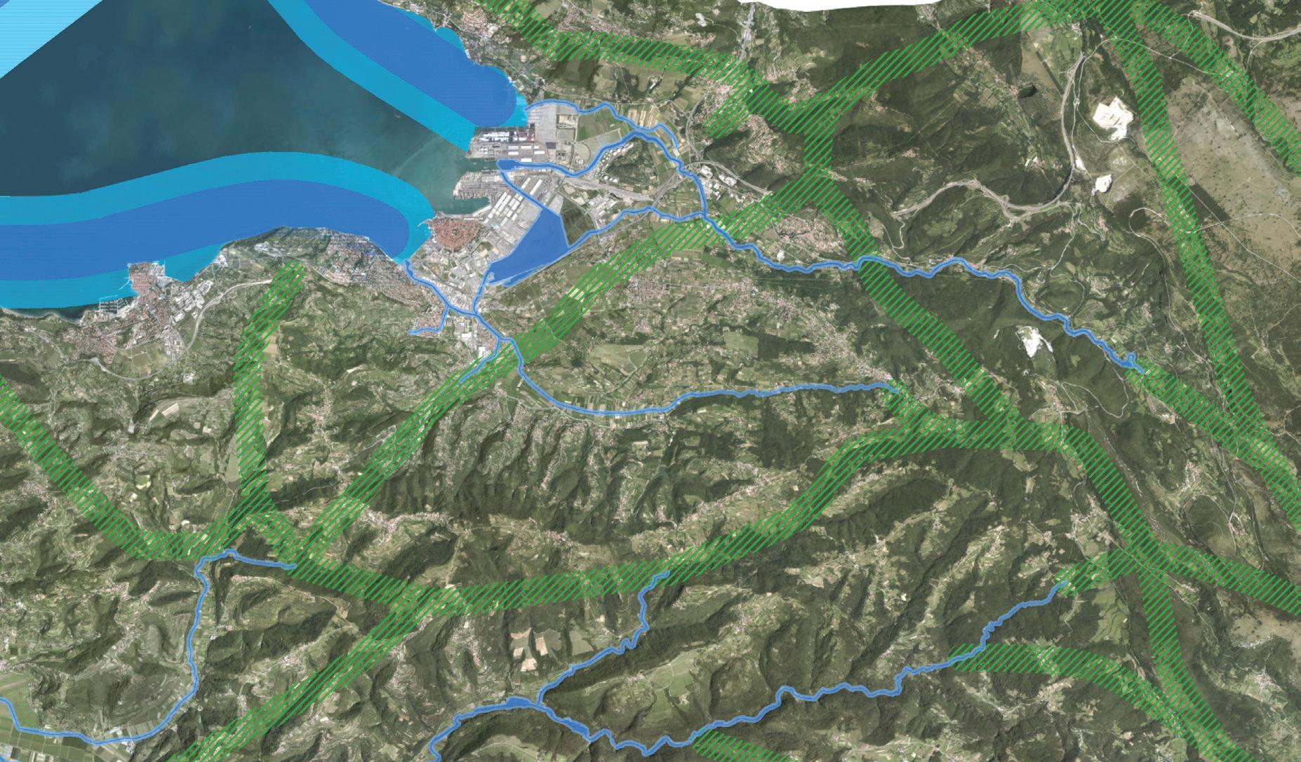
Figure 6: The link between sea and land via the blue corridors (in the sea and in water areas on land) and green corridors (on land). We use the recognised corridors on this mezzo level to show the main links for the migration of organisms, and even the transfer of energy and materials; with spatial planning on the micro level, we can adjust these to the landscape resources and other usages thereof with diversions and artificial links.


