6 minute read
3.5 Mezzo and micro level - planning green corridors at the Vipava river
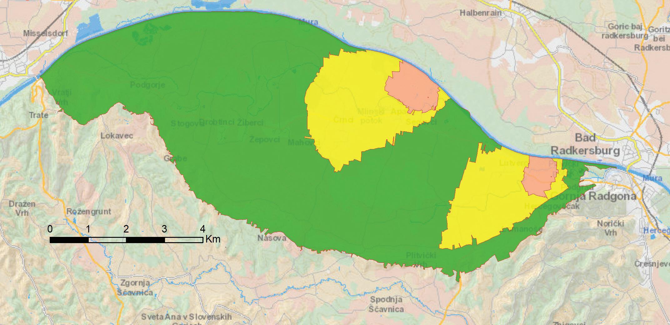
The Mura aquifer Due to the immense pressure and impact of agriculture in Austria and Slovenia on the underground water bodies in lowlands that serve as the main source for the local and regional supply of drinking water (Apače field), we have developed a modern cross-border project in the framework of the EU’s “SI-MURAT” project in order to improve the quality of the drinking water, which is based on joint measurements, modern modelling of the underground aquifer, and on the strategy for preventing excessive nutrient inputs. An important achievement is the development of the common strategy for the co-existence of agriculture and the protection of underground water, that takes into account the experiences on the Slovenian and Austrian sides. These findings and modern tools are beneficial for all the inhabitants in the region, because they can improve the situation of the environment. The SI-MUR-AT project was concluded in 2019 with the public signing of the Memorandum by the representatives of the official representative of Slovenia and Austria. The Memorandum defines the implementation of measures for achieving the goals of the strategy on both sides of the Mura river in agriculture by expanding the pilot phase of handling with nutrients and promoting bilateral projects for the sustainable usage of sources for drinking water and agriculture.
Figure 16: ThewaterprotectionareaoftheApačefieldaquiferontheSloveniansideoftheMurariver.
Advertisement
3�5 Mezzo and micro level - planning green corridors at the Vipava river
In the cross-border project GREVISLIN (“Green infrastructure - conservation and improvement of the status of endangered species and habitat types along rivers”), which is co-financed in the scope of the Interreg project of Italy-Slovenia, we used the development method for recognising GI on the mezzo level (the river basin level) and as the basis for planning the GI on the micro level.
On the mezzo level, the GI at the Vipava river basin in the lowland area, where there are intensive areas of cultivation, is recognised with a lower value. In the scope of the project, we analysed the overlaps of two target species in the area: the scarce large blue (Maculinea teleius) and the large copper (Lycaena dispar). Both butterflies are on the red list of endangered animal species and are protected in Slovenia.
Habitat type: lowland, extensively propagated meadows (Alopecurus pratensis, Sanguisorba officinalis).
The analysis results have shown a tight overlapping of areas. Further analyses then confirmed the tight overlapping of the habitat type of extensive meadows with flood areas. Based on the analyses, we have found that the flood areas near the Vipava river enable the development of the habitat type of lowland extensively propagated meadows, which are a suitable living environment for the target types of butterflies. By appropriately preserving these meadows, both endangered butterfly species may thus be preserved.
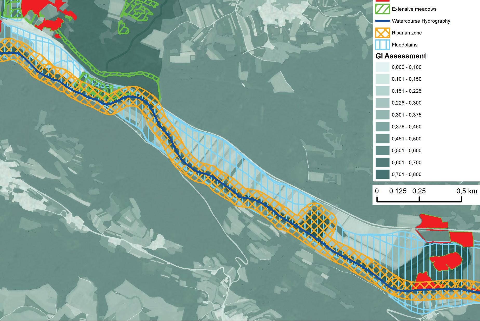
Planning measures for the development of GI on the micro level at the Vipava river basin is shown for the area of Selo, in the municipality of Ajdovščina (Figure 18). Based on the recognition on the mezzo level, there is a tendency/possibility of linking areas of extensively propagated lowland meadows at Selo, where there are intensive areas of cultivation.
During the determination of the measures that address the establishment of a habitat type of ex-

Figure 17: Planning GI in order to preserve the habitats of the scarce large blue and the large copper: the establishment of the requiredcorridors(yellowline)betweenareas on themezzo levelofadequatefloodsafety(theInterreg - Grevislinproject).
tensively propagated lowland meadows, we have found that occasional floods are present at the area in question, which indirectly enables the development of extensive meadows. The GI planning is based on the joint overview of the environmental legal regimes and their synergistic potentials. This is why we reviewed the measures or restrictions on the mezzo level of the recognised green corridor in this area, which, together with the regulations or legislations, govern the said area, as well as the measures that have been included in the Natura 2000 Management Programme (hereinafter: PUN) and relate to the target habitat type and target species.
In line with the regulations concerning waters, it is forbidden to use fertilisers or means for the protection of plants on coastal land. For the target species and target habitat type, the PUN assumes measures without fertilisers, extensive damp meadows that are occasionally flooded, mowing after a certain
date, etc. In this specific case, we recognised the possibility to develop the GI in the area of coastal land. By changing the usage of the coastal land, the stock of the target ES would increase, i.e. the increase of biodiversity. To assess the efficiency of such a measure, the benefits and costs must first be assessed in terms of the benefits due to the increase of the stock of other spatial services or costs due to the reduction in the stock of certain spatial services. We have therefore found: • an increase of the stock of other spatial services: self-cleaning ability of the stream and thus an improvement of the ecological situation of the Vipava river, the enablement/preservation of high water floods or the retention ability, the establishment of habitats and corridors for other animals, recreation, an increased production of fodder, anti-erosion protection or the retention of the soil, etc.; • a reduction in the stock of other spatial services: reduced production of the extensively produced food.
Based on the recognised benefits and costs of planning the green corridor and adjustment of the uses of coastal land, which is 40 metres wide in the case of the Vipava river (the first order stream), a wider agreement must be made between the stakeholders in order to arrange the green corridor, especially with the agricultural sector on one hand and the environmental and water protection sector on the other hand.
The success of the GREVISLIN project is mainly the discovery that environmental sectors may achieve their goals more efficiently if they connect with each other. In this case, the coastal land, as
a legal regime in water management, is successfully supporting the achievement of the goals of improving biodiversity.

Figure 18: PlanningGI in ordertopreserve extensivedampmeadowsandensure floodsafetyandestablisha green corridor along the coastal zone of the Vipava river (the Interreg - Grevislin project).
4THE GREEN INFRASTRUCTURE OF THE FUTURE
The area of recognising and planning the GI in Slovenia is not specifically terminologically defined. The discussion of GI and green systems is fragmented: we have no formal definition of the terms, nor do we have any statutory procedures for planning the GI or clearly defined principles for managing GI. The consequence of this fragmentation and obscurity in practice is, among other things, a less efficient management of space and natural resources. For a better overview, Figure 19 shows a cross-section of the Slovenian coastal outskirts, across the sea to Gradež on the Italian side, and “almost all” management arrangements that are present at the coast and in the sea.
However, if the guided spatial planning that considers the sectoral goals mentioned several times above, which address the ES and the GI and combines their sectoral management, then the establishment of GI management is actually just a thing of coordination.
This chapter is therefore intended to show the existing management arrangements that require the GI and that could make a step forward by connecting with other similar management arrangements. The chapter is concluded with proposals for a more comprehensive management of GI and ideas on how to implement the GI concept in Slovenia as efficiently as possible.
Linking sectoral activities/objectivities

Figure 19: The legislative framework for management at the coastal area and at sea [36.].


